Embed Size (px)
Citation preview

1
1-community.orgCOMMUNITYmany plans
one Code and Ordinance Toolkit
Code and Ordinance Toolkit
Livable Communities Planning ProjectThomas Jefferson Planning District CommissionOctober 2013
401 East Water Street, Charlottesville, VA 22902 . (434) 979-7310 . www.1-community.org


Code and Ordinance Toolkit October 2013
I
Introduction: Code and OrdinanceToolkit
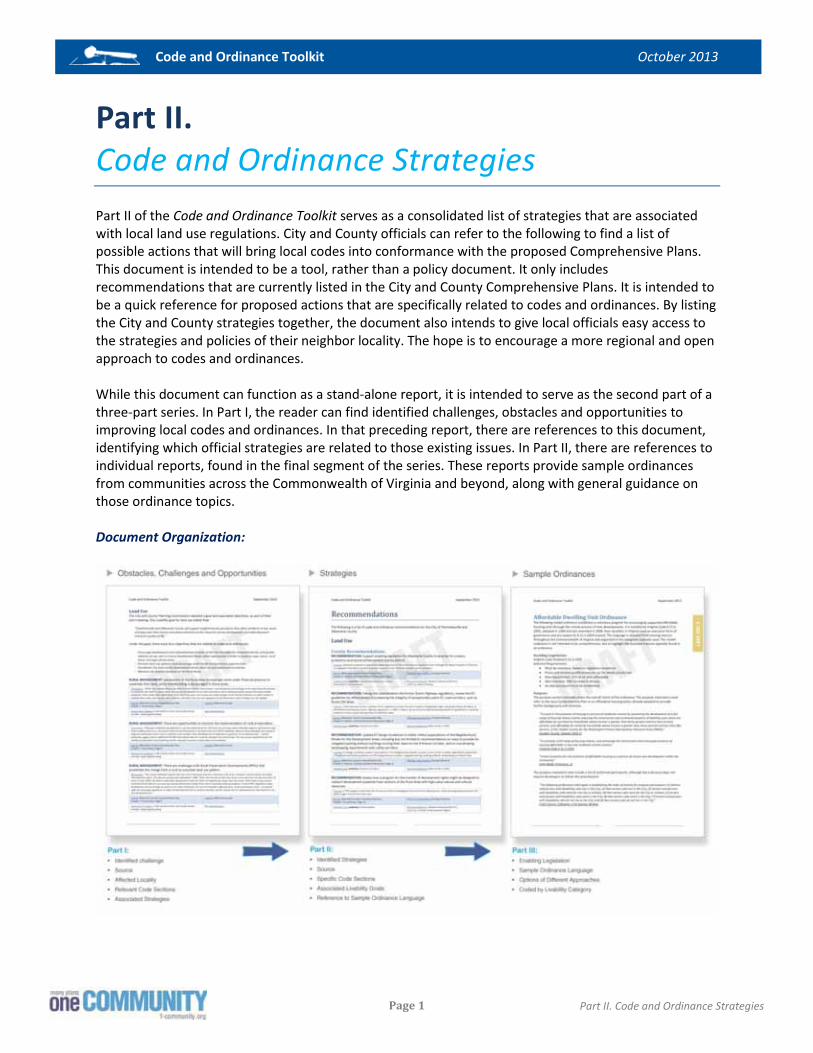
Introduction The Code and Ordinance Toolkit is a three-part reference document developed for the use of local officials at the City of Charlottesville and Albemarle County. This resource is intended to provide references on potential ways to bridge the gap between local comprehensive plans and land use regulations. While each of the following parts can function as stand-alone document, these pieces are intended to work together as a series. In Part I, the reader will find identified challenges, obstacles and opportunities with the existing codes and ordinances. In those lists of issues, there are references to the subsequent document, Part II, which consists of a list of strategies that are related to those issues. In Part II, there are further references to individual reports, found in the final segment of the series. Those reports provide sample ordinances from communities across the Commonwealth of Virginia and beyond, along with general guidance on those ordinance topics. Document Organization:
Some of the purposes for the Code and Ordinance Toolkit include:
� Creating an inventory of the City’s and County’s existing codes and ordinances; � Identifying the existing gaps between local codes and the updated comprehensive plans; � Providing local officials with a reference document, or catalog, of options that can help close
those gaps; � Creating a list of sample ordinances to provide detail on options listed in the catalog.
Note: This document is not intended to serve as an academic reference on planning concepts or zoning principles. It is not a set of recommended changes to City and County regulations. Instead, it provides information which the localities may wish to review for background information on how other localities have implemented similar goals, objectives, and strategies in their respective plans.
Code and Ordinance Toolkit October 2013
II
Introduction: Code and OrdinanceToolkit
As a reference document, the reader will likely refer to specific sections, rather than read through the entire text at a single time. Consequently, there are repetitive themes and duplicate language in the text. Also, since local officials are the main audience, the text assumes that the reader has basic knowledge of zoning and subdivision codes.
Part I: Obstacles, Challenges and Opportunities Part I of the Code and Ordinance Toolkit serves as a consolidated list of identified obstacles, challenges and opportunities associated with local land use regulations. City and County officials can refer to Part I to find a list of existing issues.
Part II: Code and Ordinance Strategies Part II of the Code and Ordinance Toolkit serves as a consolidated list of strategies that are associated with local land use regulations. City and County officials can refer to Part II to find a list of possible actions that will bring local codes into conformance with the proposed Comprehensive Plans.
Part III: Sample Ordinances Part III of the Code and Ordinance Toolkit serves as a packet of sixteen reports on various ordinance topics. These reports include codes and ordinances from localities in Virginia and other states that can provide guidance to the City and County on ways to update their codes to implement their respective comprehensive plans. Reports also include references to the State Code, for enabling legislation. This series of reports serves as a reference resource, rather than a policy document. It is intended to be an easy-to-use guide for local staff and officials, providing a starting point for additional code and ordinance research.

Code and Ordinance Toolkit October 2013
III
Introduction: Code and OrdinanceToolkit
LIVABLE COMMUNITIES In February 2011, the U.S. Department of Housing and Urban Development (HUD) awarded funding to the Charlottesville Albemarle Metropolitan Planning Organization (MPO) to develop a Livability Implementation Plan for the region. The process to develop this plan, referred to as the Livable Communities Planning Project, built upon the region’s 1998 Sustainability Accords and other local planning documents to integrate crosscutting strategies for land use, transportation, housing, economic vitality, air and water quality, and energy use. The Livable Communities Planning Project provides an avenue for inter-locality coordination, education and community participation in updates to the City of Charlottesville and Albemarle County Comprehensive Plans and the Charlottesville-Albemarle Long Range Transportation Plan. The process sought to identify common ground between City and County planning goals and to give community members the opportunity to provide feedback. Each locality used community input received through this process to inform updates to their respective planning documents. Project staff consisted of those from the City, County, University of Virginia and the Thomas Jefferson Planning District Commission. This project team assisted in coordinating public input into the three plan updates. The team also collaborated with other project partners to complete the five deliverables that comprise the Livability Implementation Plan. These five deliverables included:
1. A Performance Measurement System to analyze where the region stands with respect to transportation, the environment, housing, economic development, and energy use.
2. A single map, referred to as “One Map,” reflecting future land use designations and transportation projects for both the City of Charlottesville and the County of Albemarle.
3. A list of recommended Livability policies, goals, and objectives to inform the Charlottesville and Albemarle Comprehensive Plans, and the MPO Long Range Transportation Plan.
4. A Code and Ordinance Review that includes guidance to help implement recommended Livability policies.
5. Recommendations for voluntary individual and community-wide actions that will support Livability within the community.
CODE AND ORDINANCE REVIEW Task four of the Livable Communities Project consisted of a detailed review of local codes and ordinances. This report serves as the main deliverable of those efforts. It identifies sections of the existing regulations that are inconsistent with the Livability Goals, and offers a catalog of strategies that may help local officials create greater consistency between their plans and ordinances.

Code and Ordinance Toolkit October 2013
IV
Introduction: Code and OrdinanceToolkit
PROCESS The review of codes and ordinances involved a thorough process including staff from the City of Charlottesville, Albemarle County, Thomas Jefferson Planning District and other stakeholders. This effort spanned from April to October 2013. During this time, the project scope included:
1) A review of comprehensive plans and goals; 2) A review of local ordinances; 3) Research of best practices; and 4) Development of the results and toolkit in this report.
The updates of the City and County comprehensive plans were closely tied to this task. Early in the update process, the local planning commissions from both localities held joint meetings and agreed upon a set of joint goals and objectives, which helped set the foundation for their plan updates. The task four efforts focused on identifying areas of the local codes and ordinances that were inconsistent with those plans and goals.
COMPREHENSIVE PLAN UPDATES The greatest benefit of the Livable Communities Project was the timing related to the local plan updates. The City, County and MPO updated their major plans at the same time. Consequently, it was possible for all entities to work together on the development of goals, objectives and strategies. The following sections provide a brief summary of the updates to the City and County comprehensive plans. Since those documents serve as the legal guide for land use regulations, this overview also serves as the basis for the code and ordinance review.
Joint Goals One of the most important activities in the Livable Communities Project was the Joint Planning Commission process. In a series of meetings, the Charlottesville and Albemarle Planning Commissions met together for joint sessions. These sessions allowed the Planning Commissioners to discuss issues of overlapping concern. It also allowed officials to share existing approaches and identify key issues that needed to be addressed by both localities. Through the course of this process, the two Planning Commissions identified eight areas of joint interest for discussion and recommendations; Economic Development, Entrance Corridors, Environment, Housing, Land Use, Transportation, Parks and Recreation, and Historic Preservation. (These categories later served as an organizational framework for the code and ordinance review). The Planning Commissions ultimately agreed on an overall direction in these areas. The two planning commissions approved the final version of the Vision and Goal Statements at their meeting on January 15, 2013. The City incorporated many of these visions and goals into the updated comprehensive plans. The County’s recommended comprehensive plan update also included the Livability Project visions and goals. While both localities already addressed many of these topics in their previous plans, there were opportunities to expand on these discussions, as is seen in the updates.
City of Charlottesville While the City of Charlottesville did not make any major policy changes in their comprehensive plan update, there were extensive refinements. The public feedback centered on retaining the previous qualities of the plan, rather than conducting a complete overhaul of the community’s vision. The land use and housing sections received the most attention. From a formatting standpoint, the City reduced

Code and Ordinance Toolkit October 2013
V
Introduction: Code and OrdinanceToolkit
the content to make the plan more user-friendly. The City focused on creating a forward looking, expressive vision for the community, as opposed to an almanac of various planning topics. The plan consists of several chapters, which cover seven main topics: land use, community facilities, economic sustainability, environment, housing, and transportation, along with urban design and historic preservation. The final chapter focuses on implementation of the goals and objectives that the City listed in the plan.
Albemarle County Over time, the County’s Comprehensive Plan has consistently established one overriding policy – growth management. The plan’s emphasis is on channeling growth into the County’s designated Development Areas, whereby protecting designated Rural Areas. Periodic reviews and amendments have not changed this emphasis. The Planning Commission, early in its latest review of the plan, reaffirmed this approach and focused on expanding strategies that implement these policies. When the 2013 update began, the Comprehensive Plan consisted of five different sections: Natural and Cultural Resources, the Land Use Plan for the Development Areas, the Rural Area Plan, Economic Development Policies, and the Affordable Housing Policy. There were multiple appendices within each of the first three sections, which made the document excessively bulky with over 700 pages in total. The 2013 update brought these different chapters together under one volume, “The 20-Year Plan.” The new format provided greater consistency within and among chapters. This update also allowed the County to streamline the plan, removing redundancies and focusing on essential topics. As a result, the 2013 draft is a more concise, user friendly plan that consists of three main volumes:
� Summary of the Plan � 20-Year Plan � Reference Documents
EXISTING ORDINANCES AND POLICIES The City of Charlottesville and Albemarle County have a history of innovations in planning and land use policies. Both localities have existing ordinances that address issues related to housing, transportation, sustainability, neighborhood design, economic development and many other topics. The following sections document those ordinances. The purpose of this summary is two-fold. First, it acknowledges those previous efforts by the localities. Second, this background provides context to the code and ordinance considerations listed in the toolkit sections.
City of Charlottesville While the City of Charlottesville has a long history with zoning and subdivision regulations, there was a complete rewrite of the zoning code in 2003. The current ordinance is the product of the City’s 2001 Comprehensive Plan. During the 2001 process, citizens and officials debated what type of community it wished to be in the coming years. After extensive public meetings, there was consensus that the City’s priority was to foster a pedestrian-oriented, walkable, and transit-friendly community. Growing out of that process was a realization that the existing zoning ordinance would not allow the City to achieve that vision. That realization served as the foundation for the 2003 zoning overhaul and later updates to the subdivision ordinance.

Code and Ordinance Toolkit October 2013
VI
Introduction: Code and OrdinanceToolkit
Zoning Ordinance
The City adopted a set of guiding principles during the 2001 Comprehensive Plan update that acted as the cornerstone for the new zoning ordinance. The principles focused on several keys topics, including strong neighborhoods with identifiable centers, accessibility to safe alternative modes of transportation, an emphasis on parks and natural resources, quality and affordable housing, a diversified economy and citizenry, and sustainable practices. In response to the comprehensive plan and guiding principles, the 2003 zoning ordinance included these main features:
1. Zoning districts/standards that support neo-traditional design. 2. Zoning and codes that accurately reflect the future land use plan. 3. Student precincts adjacent to the University that allow for lower on-site parking requirements
and higher residential densities. 4. A zoning classification that acknowledge parks. 5. Higher Densities clustered along Transit Corridors. 6. Districts that focus on major corridors throughout the City. 7. Provisions dedicated to the preservation of historic resources. 8. Provisions that address bike racks/lockers at businesses and apartments. 9. New regulations allowing accessory units in single-family zones by provisional use to enhance
the character of some neighborhoods. 10. Parking standards which require fewer spaces, particularly along transit corridors.
Since 2003, the City made additional updates to the zoning ordinance, particularly related to affordable housing. The City received special permission from the State General Assembly to adopt provisions that integrate affordable housing units into market rate developments. Aside from targeted updates, the 2003 zoning ordinance is largely intact. The code sections are organized into ten articles. There are ten residential zoning districts, plus the Planned Unit Development district. The City also has four commercial districts, four overlay, two industrial and fourteen mixed-use corridor districts.
Note: Refer to the Appendix for a list and description of the various zoning districts.
Subdivision Ordinance
The City rewrote their subdivision ordinance in 2008, which completely replaced the previous subdivision ordinance. The purpose of the new ordinance was two-fold. First, it reflects and incorporates current Virginia state law on subdivisions. Second, it is intended to codify procedures and practices in the administration of subdivisions within the City. The City also developed a Standards and Design Manual which contains engineering specifications. While the Commission and staff, in applying City ordinances, dictate what must be built pursuant to a development application, the Standards and Design Manual specify how it shall be built.
Albemarle County Albemarle County has used its zoning and subdivision ordinance to help implement its Comprehensive Plan for decades. In 1980, the County revised its zoning ordinance to reduce development potential in the Rural Areas and promote growth in the Development Areas. In 1990, the County adopted the Entrance Corridor Overlay District to help protect scenic and historic resources and appointed its first

Code and Ordinance Toolkit October 2013
VII
Introduction: Code and OrdinanceToolkit
Architectural Review Board. In 1991, the County adopted a Water Protection Ordinance which underwent a major update in 1998. By the 2000s, Albemarle County made several significant and innovative changes to its codes and ordinances to better shape new development, especially in the Development Areas.
The Neighborhood Model
In 2001, Albemarle County adopted a neighborhood design concept that focused on compact, mixed-use developments with an urban scale for the designated Development Areas. This concept, referred to as the Neighborhood Model, was intended to encourage a neo-traditional design. The new policy consisted of twelve principles:
� Pedestrian orientation, � Neighborhood friendly streets and paths, � Interconnected streets and transportation networks, � Parks and open space as amenities, � Neighborhood centers, � Buildings and spaces of human scale, � Relegated parking, � Mixture of uses and use types, � Mixture of housing types and affordability, � Redevelopment, � Site planning that respects terrain, and � Clear boundaries with the rural areas. In 2003, the County adopted the Neighborhood Model District (NMD). The County designed this district to implement the model and its twelve principles. The NMD ordinance functions as a planned development district that offers flexibility to applicants. While there is flexibility, County still retains discretion to negotiate on proffers and development plans.
Downtown Crozet District
In 2008, the County adopted a new district that functions like a form-based code and targets the same principles as the NMD. The Downtown Crozet District (DCD) helps implement traditional downtown development in the Crozet community, per the vision outlined in the Crozet Master Plan. The DCD provides for flexibility and variety, by allowing for a mixture of uses. As an example, a development could consist of retail, service, and civic uses with light industrial and residential property as secondary uses. This district is intended to promote a development form and character that is different from typical suburban development allowed by conventional zoning. The stated goals are to:
� Promote the economic and social vitality and diversity of downtown Crozet; � Implement the Crozet master plan for the downtown area of Crozet so that it may serve as the
commercial hub of Crozet and its environs; � Provide a greater mix of uses in downtown Crozet, including increased employment; � Facilitate infill and redevelopment; � Increase the utility of the land; � Retain the uniquely diverse character of Crozet; and � Promote a pedestrian-friendly environment.
Neighborhood Design
The County made additional ordinance amendments to shape the form of suburban developments. In 2002, the Board of Supervisors adopted an ordinance change that would allow for alleys in the

Code and Ordinance Toolkit October 2013
VIII
Introduction: Code and OrdinanceToolkit
designated Development Areas. In the following year, there was an amendment to the zoning ordinance to reduce parking requirements and encourage travel demand management (TDMs) in the Development Areas. In 2005, the County started to require sidewalks and interconnections in Development Areas and permitted zero lot line development in 2008. All of these changes promote a more urban design than conventional zoning districts.
Environmental Ordinances
During the 2000s, Albemarle County adopted several ordinance changes related to water protection. In 2004, there was an amendment to the water protection ordinance intended to protect groundwater. This ordinance tracks well locations and yields by location in the designated Rural Area as a way to measure change in groundwater quantity and quality. There was another amendment in 2007 to strength the Water Protection ordinance with regards to water quality.
Rural Zoning
Albemarle County’s rural areas and natural resources are considered to be the County’s most valued assets. The Rural Area zoning has strong limits on residential development. After the last update of the Rural Area portion of the comprehensive plan, the County determined that there needed to be greater opportunity for agricultural uses. In 2006, there were amendments to the zoning ordinance to allow for seasonal farm worker housing in the Rural Areas. Two years later, there was an amendment to the zoning ordinance to broaden opportunities at country stores that could serve the rural residents. In the next two years, the County adopted a pair of new amendments. The first amendment increased opportunities for local food sales through farm stands and farmers markets. The second amendment to the Rural Areas zoning district opened more opportunities for farm wineries and their ability to hold special events.
Note: Refer to the Appendix for a list and description of the various zoning districts.
Subdivision Ordinance
The County’s subdivision regulations changed in 2005 to require that street connections be built to the property line of adjoining properties. This continues to be important in new developments to avoid creating an isolated environment that requires motorists to travel long, roundabout routes. Although street connections are generally resisted by existing neighborhoods, connections provide alternate traffic routes for old and new neighborhoods, which can also improve emergency response time.

Code and Ordinance Toolkit October 2013
Page 1
Part I. Obstacle, Challenges and Opportunities
Part I. Obstacles, Challenges and Opportunities Part I of the Code and Ordinance Toolkit serves as a consolidated list of identified obstacles, challenges and opportunities associated with local land use regulations. City and County officials can refer to the following sections of this report to find a list of existing issues. This document is intended to be a tool, rather than a policy document. It only includes topics that are currently listed in the City and County Comprehensive Plans and is intended to be a quick reference that is specifically related to codes and ordinances. By listing the City and County issues together, the document also gives local officials easy access to the topics discussed in their neighbor locality. The hope is to encourage a more regional and collaborative approach to code and ordinance development. While this document can function as a stand-alone report, it is intended to serve as the first part of a three-part series. In this document, the reader can find identified challenges, obstacles and opportunities to improving local codes and ordinances. There are references to the subsequent document, Part II, which consists of a list of strategies that are related to the following issues. In Part II, there are further references to individual reports, found in the final segment of the series. Those reports provide sample ordinances from communities across the Commonwealth of Virginia and beyond, along with general guidance on those ordinance topics. Document Organization:

Code and Ordinance Toolkit October 2013
Page 2
Part I. Obstacle, Challenges and Opportunities
NAVIGATING PART I The layout of Part I is intended to allow easy reference for the reader to find a list of existing obstacles, challenges and opportunities with codes and ordinances. The document divides these issues by categories, taken from an adopted list of Livability Goals, as part of the Livability: Many Plans One Community project. Since a single issue can overlap multiple topics, there are multiple references across categories. With each topic on the following pages there is a table of information that creates a general profile. The table contains:
� Description: The description line provides details of identified issues from local plans or other official documents.
� Source: This line includes a specific reference to the local comprehensive plan. It allows the reader to identify the comprehensive plan chapter and section associated with each issue.
� Locality: The tables identify which locality (City or County) is affected by the stated obstacle, challenge or opportunity.
� Assessment Category: This line indicates the type of ordinance change needed to address the identified issue. The assessment category indicated either: code sections which the locality should consider replacing/amending, because they conflict with the livability strategies; or, code sections which do not exist and would need to be created.
� Strategies: The final line in the table includes references to Part II, a consolidated list of local strategies taken directly from the City and County comprehensive plans. These references make a link between identified issues and proposed actions.
PART I SECTIONS BY TOPIC: �� LAND USE ........................................................................................................................................3 � HOUSING .........................................................................................................................................6 � ECONOMIC DEVELOPMENT ...................................................................................................................8 � HISTORIC PRESERVATION .....................................................................................................................9 � ENVIRONMENT ................................................................................................................................ 11 � ENTRANCE CORRIDORS ...................................................................................................................... 13 � TRANSPORTATION ............................................................................................................................ 15

Code and Ordinance Toolkit October 2013
Page 3
Part I. Obstacle, Challenges and Opportunities
�� LAND USE The City and County Planning Commissions recommended goals and associated objectives as part of their joint work for the Livability Project. The recommended Livability goal for land use is:
“Charlottesville and Albemarle County will support neighborhoods and places that allow residents to live, work, and play near their homes and where attention to the character of new development and redevelopment enhances quality of life.”
Under this goal, there were four objectives that are related to codes and ordinances:
� Encourage development and redevelopment in areas of the City identified for increased density and greater intensity of use, and in County Development Areas where appropriate in order to preserve open space, rural areas, and agricultural areas.
� Promote land use patterns that encourage multi-modal transportation opportunities. � Coordinate City and County Development Areas, land use and infrastructure policies. � Maintain the distinct character of the Rural Areas.
Of these items, the local comprehensive plans give attention to the following areas: RURAL PRESERVATION: Rural landowners increasingly come under financial pressure to subdivide their land.
Description: “While new homebuilding is not desired in the County’s Rural Areas, rural landowners increasingly come under financial pressure to subdivide their land. In recent years, the County has realized it must take a proactive role in helping property owners find ways to keep properties intact rather than subdividing. In the last three years, the County has made changes to the Zoning Ordinance to make it easier to establish farm sales, farm stands, farm wineries, and other uses that are supportive of the Rural Area. Other changes are still needed.”
Source: Albemarle County Comprehensive Plan, Chapter 7: Rural Areas, Page 3
Locality: Albemarle County
Assessment Category: Code sections which do not exist and would need to be created
Strategies: Land Use A-12, A-14, A-15, A-16
RURAL COMMUNITIES: There are opportunities to increase the number of places for community interaction in the Rural Area.
Description: “Community gathering places for residents of the Rural Areas are somewhat limited… The Zoning Ordinance permits churches, community centers, and clubs in the Rural Area zoning district by special use permit. Most requests are approved because requests are in keeping with the Comprehensive Plan goals. Outside of those facilities, locations for community interaction are limited to informal locations such as businesses, post offices, schools, and existing country stores. Community centers and areas of religious assembly are considered to be supportive of local rural residents. ”
Source: Albemarle County Comprehensive Plan, Chapter 7: Rural Areas, Page 21
Locality: Albemarle County
Assessment Category: Code sections which do not exist and would need to be created
Strategies: Land Use A-13

Code and Ordinance Toolkit October 2013
Page 4
Part I. Obstacle, Challenges and Opportunities
MAINTAINING HISTORIC PROPERTIES: Limitations on allowable uses may limit the ability of some landowners to maintain their historic properties.
Description: “While valued by residents and tourists alike, historic buildings and sites can sometimes pose challenges for owners. Large farmhouses and historic mansions can be expensive to maintain and, at times, additional income is needed to ensure that historic buildings do not fall into disrepair. Historic buildings and sites can be maintained for their original use, such as a home, or converted to income producing properties, such as restaurants, museums, and lodging.”
Source: Albemarle County Comprehensive Plan, Chapter 7: Rural Areas, Page 22
Locality: Albemarle County
Assessment Category: Code sections which do not exist and would need to be created
Strategies: Land Use A-12, A-14, A-15, A-16
RURAL DESIGN: There are opportunities to introduce design standards for rural area uses.
Description: “Standards in the Zoning Ordinance were developed as a ‘one-size-fits-all’ scenario and have increasingly become more urban to support the Development Areas. Rural standards are needed to help uses better blend into the rural landscape and function more as a rural use… Performance standards are needed that ensure that size, scale, and location of new uses do not overwhelm the area in function or visibility.”
Source: Albemarle County Comprehensive Plan, Chapter 7: Rural Areas, Page 25
Locality: Albemarle County
Assessment Category: Code sections which do not exist and would need to be created
Strategies: Land Use A-17, A-18
STREET DESIGN: There are opportunities to create blocks in conjunction with the County’s challenging topography.
Description: “Short block length is also an important part of creating an incentive for walking. Blocks provide a frame of reference for walkers as pedestrians often measure distance from one place to another by counting the number of blocks. The shorter the blocks, the more comfortable the walk, especially if one has to walk a long distance. As a rule, blocks should not exceed 600 feet in length. Albemarle County’s topography represents challenges to creating a true grid-system.”
Source: Albemarle County Comprehensive Plan, Chapter 8: Development Areas, Page 13
Locality: Albemarle County
Assessment Category: Code sections which do not exist and would need to be created
Strategies: Land Use A-19
PLANNED DISTRICTS: There are opportunities to improve the Planned Unit Development (PUD) District, to ensure that those developments include the neighborhood designs outlined in the comprehensive plan.
Description: “The PUD districts are intended to serve as neighborhoods or mini-neighborhoods within designated communities and the urban area. Additionally, PUD districts may be appropriate where the establishment of a "new village" or the nucleus of a future community exists and where the PUD development would not preclude achievement of the county's objectives for the urban area, communities and villages. In order to encourage the community function, appropriate commercial and industrial uses are provided in addition to a variety of residential uses. It is intended that commercial and industrial development be limited to a scale appropriate to the support of the residential uses within the PUD; provided that additional commercial and industrial activity may be permitted upon a finding that the area in which the PUD is to be located is not adequately served by such use.” City of Charlottesville Zoning Ordinance
Source: City of Charlottesville Comprehensive Plan, Land Use Chapter: Action 5.1; Urban Design and Historic Preservation Chapter: Action 7.5
Locality: City of Charlottesville
Assessment Category: Code sections which the locality should consider replacing/amending
Strategies: Land Use C-1

Code and Ordinance Toolkit October 2013
Page 5
Part I. Obstacle, Challenges and Opportunities
INFILL & REDEVELOPMENT: There are opportunities to improve the Infill Special Use Permit. Description: “Infill development is a concept by which the city desires to encourage and permit variation in certain areas within the city's R-1, R-1S, R-2 and R-3 zoning districts, by allowing deviation from the following types of regulations pursuant to a special use permit: minimum lot size and street frontage requirements, dimensional requirements, types of dwellings, density, yard requirements. In an effort to promote a walkable community, to reduce traffic congestion, to improve air quality, and to enhance the viability of downtown businesses, the city seeks to encourage increased density of residential development in central Charlottesville and the Main Street corridor, where access to a variety of transportation options allows for increased density with less impact on traffic and promotes a healthy lifestyle for city residents.” City of Charlottesville Zoning Ordinance
Source: City of Charlottesville Comprehensive Plan, Land Use Chapter, Action 5.2
Locality: City of Charlottesville
Assessment Category: Code sections which the locality should consider replacing/amending
Strategies: Land Use C-2, C-6
INDUSTRIAL DEVELOPMENT: The existing industrial zoning could better align with the City’s economic development goals.
Description: “The M-I district is established to allow areas for light industrial uses that have a minimum of environmental pollution in the form of traffic, noise, odors, smoke and fumes, fire and explosion hazard, glare and heat and vibration.” City of Charlottesville Zoning Ordinance
Source: City of Charlottesville Comprehensive Plan, Land Use Chapter: Action 5.6
Locality: City of Charlottesville
Assessment Category: Code sections which the locality should consider replacing/amending
Strategies: Land Use C-5

Code and Ordinance Toolkit October 2013
Page 6
Part I. Obstacle, Challenges and Opportunities
�� HOUSING The City and County Planning Commissions recommended goals and associated objectives as part of their joint work for the Livability Project. The recommended Livability goal for housing is:
“Charlottesville and Albemarle County will each have a range of housing types that support various incomes, ages, and levels of mobility. These housing types should be connected to community amenities, parks, trails and services in the City and in the County’s Development Areas.”
Under this goal, there were four objectives that are related to codes and ordinances:
� Encourage mixed income communities. � Develop policies to encourage housing opportunities suitable for healthy aging and for people
with disabilities located in close proximity to community services and amenities, recreational resources, and connected to multi-modal transportation corridors.
� Promote housing located near employment centers in the City and County Development Areas and optimal multi-modal transportation links between those areas and major employment centers.
� Increase the range of housing type choices, focusing especially on the creation of additional workforce (60%-120% AMI), affordable housing (25%-60% AMI), and deeply affordable (0%-25% AMI) units in the City and the County.
Of these items, the local comprehensive plans give attention to the following areas: ACCESSORY UNITS: There are opportunities to allow for detached accessory units in new residential developments.
Description: “Accessory units, both attached and detached, are an integral part of a diverse housing supply. Sometimes called “granny flats” or “in-law apartments,” they provide an opportunity for individuals in need of assistance to live on-site with care-giving relatives, or provide a way for owners to supplement an income and help pay for the mortgage. Recommendations to increase opportunities to construct accessory units were made with the Neighborhood Model, in 2001. Some creative ways of providing accessory units have been achieved in Neighborhood Model developments; however, limitations remain. Zoning Ordinance amendments are needed to allow for detached accessory units to be constructed.”
Source: Albemarle County Comprehensive Plan, Chapter 9: Housing, Page 6
Locality: Albemarle County
Assessment Category: Code sections which the locality should consider replacing/amending
Strategies: Housing A-1
AFFORDABLE HOUSING: Zoning district requirements may present obstacles to affordable housing.
Description: “Residential districts in the Development Areas limit density and require a minimum lot size. These two features should be reviewed to see if [changes]… could allow for additional opportunities for affordable housing.”
Source: Albemarle County Comprehensive Plan, Chapter 9: Housing, Page 10
Locality: Albemarle County
Assessment Category: Code sections which the locality should consider replacing/amending
Strategies: Housing A-3

Code and Ordinance Toolkit October 2013
Page 7
Part I. Obstacle, Challenges and Opportunities
GREEN BUILDING: There are opportunities to better address green building in home construction. Description: “To use renewable energy sources, resource-efficient principles of design and construction, and sustainably produced materials in all new construction, and sustainably produced materials in all new structures; and to encourage conversion from less efficient, non-renewable energy uses in existing structures. City of Charlottesville Comprehensive Plan, Sustainability Accords
Source: City of Charlottesville Comprehensive Plan, Environmental Chapter: Action 5 Housing Chapter: Action 8.7
Locality: City of Charlottesville
Assessment Category: Code sections which do not exist and would need to be created
Strategies: Housing C-4, C-7
MAINTAINING AFFORDABILITY: There are opportunities to better maintain the stock of affordable housing.
Description: “Localities play a vital role in affordable housing through the adoption and implementation of strategies and policies. Localities use Land Use and Zoning tools, such as the Comprehensive Plan and Zoning Ordinance, lay out a framework to guide how and where housing is built and maintained within an area.” City of Charlottesville Comprehensive Plan, State of the Housing Report
Source: City of Charlottesville Comprehensive Plan, Housing Chapter, Action 4.3
Locality: City of Charlottesville
Assessment Category: Code sections which do not exist and would need to be created
Strategies: Housing C-2
QUALITY AFFORDABLE HOMES: There are challenges that limit the City’s ability to ensure that affordable homes are visually indistinguishable from market-rate lots.
Description: “Location and appearance are important when providing affordable housing. Affordable units should not be segregated from other types of housing or built in enclaves. Instead, units should be scattered throughout the Development Area Neighborhoods. To help achieve a more cohesive looking neighborhood and retain property values, affordable units should not be distinguishable on the outside from market rate units.” Albemarle County Comprehensive Plan, Housing Chapter
Source: City of Charlottesville Comprehensive Plan, Housing Chapter, Action 7.1
Locality: City of Charlottesville
Assessment Category: Code sections which do not exist and would need to be created
Strategies: Housing C-5
Code and Ordinance Toolkit October 2013
Page 8
Part I. Obstacle, Challenges and Opportunities
�� ECONOMIC DEVELOPMENT The City and County Planning Commissions recommended goals and associated objectives as part of their joint work for the Livability Project. The recommended Livability goal for economic development is:
“Charlottesville and Albemarle County recognize the necessity of vibrant regional economic relationships and will work together toward a strong, diversified economy creating stability and opportunities for advancement in our communities.”
Under this goal, there were three objectives that are related to codes and ordinances:
� Improve opportunities for employment centers that are connected to community amenities, housing, and services in the City and in the County’s Development Areas.
� Support a range of businesses in identified target industry areas (bioscience and medical, business and financial, information technology & defense, and agribusiness).
� Encourage land use practices and policies that promote vibrancy in the local economy through cultural industries including heritage tourism, entertainment, agritourism, local food, and art, and entertainment.
Of these items, the local comprehensive plans give attention to the following areas: REUSE: Limitations on allowable uses may be an obstacle for some landowners to maintain their historic properties.
Description: “While valued by residents and tourists alike, historic buildings and sites can sometimes pose challenges for owners. Large farmhouses and historic mansions can be expensive to maintain and, at times, additional income is needed to ensure that historic buildings do not fall into disrepair. Historic buildings and sites can be maintained for their original use, such as a home, or converted to income producing properties, such as restaurants, museums, and lodging.”
Source: Albemarle County Comprehensive Plan, Chapter 7: Rural Areas, Page 22
Locality: Albemarle County
Assessment Category: Code sections which do not exist and would need to be created
Strategies: Economic A-8, A-9, A-10, A-11
INDUSTRIAL DEVELOPMENT: The existing industrial zoning could better align with the City’s economic development goals.
Description: “The M-I district is established to allow areas for light industrial uses that have a minimum of environmental pollution in the form of traffic, noise, odors, smoke and fumes, fire and explosion hazard, glare and heat and vibration.” City of Charlottesville Zoning Ordinance
Source: City of Charlottesville Comprehensive Plan, Land Use Chapter: Action 5.6
Locality: City of Charlottesville
Assessment Category: Code sections which the locality should consider replacing/amending
Strategies: Economic C-1

Code and Ordinance Toolkit October 2013
Page 9
Part I. Obstacle, Challenges and Opportunities
�� HISTORIC PRESERVATION The City and County Planning Commissions recommended goals and associated objectives as part of their joint work for the Livability Project. The recommended Livability goal for historic preservation is:
“Charlottesville and Albemarle County will enhance the historic character of the region by fostering community awareness of our historic and cultural resources and promoting the preservation of designated structures and areas.”
Under this goal, there was an objective related to codes and ordinances:
� Encourage local historic designations where appropriate in cooperation with neighborhoods. Of these items, the local comprehensive plans give attention to the following areas: LOCAL HISTORIC PRESERVATION: Local historic resources may be vulnerable, due to a lack of historic districts.
Description: “Over the years, historic resource surveys have identified buildings and sites in Albemarle that are eligible for nomination to the National Register of Historic Places. However, there is no consolidated or updated list of these properties. In addition, many property owners are not aware of the historic significance of their properties, and many historic resources are demolished, leaving no record behind… Albemarle County has no local historic preservation regulations and, as a result, has no mechanism to either prevent demolition of historic resources or to require that owners document their historic resources prior to demolition.” “Although examples of successful preservation efforts in the County exist, the number of resources destroyed in recent years suggests that continued reliance solely on voluntary preservation measures would not be adequate to protect all significant resources.”
Sources: Albemarle County Comprehensive Plan, Chapter 5: Historic, Cultural and Scenic Resources, Page 4
Locality: Albemarle County
Assessment Category: Code sections which do not exist and would need to be created
Strategies: Historic A-1
REUSE OF HISTORIC PROPERTIES: Limitations on allowable uses may be an obstacle for some landowners to maintain their historic properties.
Description: “While valued by residents and tourists alike, historic buildings and sites can sometimes pose challenges for owners. Large farmhouses and historic mansions can be expensive to maintain and, at times, additional income is needed to ensure that historic buildings do not fall into disrepair. Historic buildings and sites can be maintained for their original use, such as a home, or converted to income producing properties, such as restaurants, museums, and lodging.”
Source: Albemarle County Comprehensive Plan, Chapter 7: Rural Areas, Page 22
Locality: Albemarle County
Assessment Category: Code sections which do not exist and would need to be created
Strategies: Historic A-3, A-4
POLICY CONSISTENCY: There are opportunities to ensure that standards and requirements are consistent with historic preservation goals.
Description: “To date, while the importance of urban design and historic preservation have been recognized by many, their potential to strengthen and improve the vitality of the City has not yet been fully realized. In order to maximize the benefits associated with urban design and historic preservation, they should be integrated more fully into all aspects of life in the City, and the actions of both the public and private sectors should be coordinated to achieve the goals of urban design and preservation articulated in this document.” City of Charlottesville Comprehensive Plan, Historic Preservation Appendix
Sources: City of Charlottesville Comprehensive Plan, Land Use Chapter: Action 5.4 Urban Design and Historic Preservation: Action 7.4, 7.5
Locality: City of Charlottesville
Assessment Category: Code sections which the locality should consider replacing/amending
Strategies: Historic C-1, C-4, C-5

Code and Ordinance Toolkit October 2013
Page 10
Part I. Obstacle, Challenges and Opportunities
DESIGNATIONS: Some historic resources are vulnerable or endangered and not protected by a locally designated historic district
Description: “There are eight areas of the City where historic preservation and architectural design control (ADC) districts have been designated, one neighborhood designated as a historic conservation district, and 76 individually protected properties that have been designated outside districts. The ADC districts are: Downtown, North Downtown, Ridge Street, West Main Street, Wertland Street, The Corner, Oakhurst-Gildersleeve Neighborhood, and Rugby Road-University Circle-Venable Neighborhood. Martha Jefferson Neighborhood is designated as a Historic Conservation District.” City of Charlottesville Comprehensive Plan, Historic Preservation Appendix
Sources: City of Charlottesville Comprehensive Plan, Urban Design and Historic Preservation Chapter: Action 6.1
Locality: City of Charlottesville
Assessment Category: Code sections which do not exist and would need to be created, as well as zoning map amendments
Strategies: Historic C-1, C-2
OTHER RESOURCES: The existing ordinance does not address archaeological resources.
Description: “Charlottesville’s archaeological resources are an integral part of the City’s cultural history. Examples of archaeological resources include human remains, and objects such as tools, bone, bottles, dishes, and nails, which are representative of prehistoric and historic periods. Areas that contain these objects are also archaeological resources and include graves, wells, privies, trash pits, quarries, back yards, basements, and foundations. Examples of archaeological sites within Charlottesville that might contain archaeological resources are prehistoric camps, historic residences, schools, farms, cemeteries, roads, railways and Civil War camps and hospitals.” City of Charlottesville Comprehensive Plan, Historic Preservation Appendix
Sources: City of Charlottesville Comprehensive Plan, Urban Design and Historic Preservation Chapter: Action 6.4
Locality: City of Charlottesville
Assessment Category: Code sections which do not exist and would need to be created
Strategies: Historic C-3
POLICY CONSISTENCY: The zoning ordinance allows for higher densities on specific historic properties, potentially encouraging demolition of those historic buildings.
Description: “To date, while the importance of urban design and historic preservation has been recognized by many, their potential to strengthen and improve the vitality of the City has not yet been fully realized. In order to maximize the benefits associated with urban design and historic preservation, they should be integrated more fully into all aspects of life in the City, and the actions of both the public and private sectors should be coordinated to achieve the goals of urban design and preservation articulated in this document.” City of Charlottesville Comprehensive Plan, Historic Preservation Appendix
Sources: City of Charlottesville Comprehensive Plan, Urban Design and Historic Preservation Chapter: Action 7.4
Locality: City of Charlottesville
Assessment Category: Code sections which do not exist and would need to be created, as well as zoning map amendments
Strategies: Historic C-4

Code and Ordinance Toolkit October 2013
Page 11
Part I. Obstacle, Challenges and Opportunities
�� ENVIRONMENT The City and County Planning Commissions recommended goals and associated objectives as part of their joint work for the Livability Project. The recommended Livability goal for the environment is:
“Charlottesville and Albemarle County will continue to promote a community of green neighborhoods, healthy waterways, clean air, and sustainable natural resources.”
Under this goal, there were eight objectives that are related to codes and ordinances:
� Encourage multi-modal transportation and focus development and redevelopment in urban areas that are supported by multi-modal transportation facilities that will help to reduce emissions of air pollutants and greenhouse gases.
� Protect drinking water supplies and associated watershed protection areas. � Improve water quality of all of our waterways. � Coordinate actions intended to address and meet all appropriate water quality standards. � Encourage low-impact development techniques and practices through land development
regulations, education, and incentives. � Improve the viability of local agriculture through concentrating development in the City areas
identified for greater intensity of use and higher densities and County Development Areas while strengthening measures that protect agriculture in the Rural Areas.
� Recognize the benefits of biological diversity and encourage the retention and use of native plants.
� Encourage establishment, maintenance, and replenishment of urban tree canopy in the developed areas as a means of promoting urban green space, as well as supporting stormwater runoff reduction efforts.
Of these items, the local comprehensive plans give attention to the following areas: WATER QUALITY: There are opportunities to improve on protection of critical slopes and water resources.
Description: “Soil retention is important for protecting water quality as well as for slope stability. The isolated locations of development sites in mountain areas necessitate longer driveways and access roads over more highly erodible soils. Driveways and access roads may disturb many times more area than a dwelling itself. Improper attention to soils may result in accelerated soil erosion and sedimentation, ground or surface water pollution, landslides, flooding, drainage problems, failed septic systems, construction problems, and unproductive agricultural and forestal lands. Forest cover is the most effective land cover for minimizing soil erosion and protecting water quality. Forested land cover also slows runoff and retains water, allowing it to more slowly flow to streams and groundwater supplies… The County should strengthen protection of these resources through its zoning regulations.”
Source: Albemarle County Comprehensive Plan, Chapter 4: Natural Resources, Page 18
Locality: Albemarle County
Assessment Category: Code sections which the locality should consider replacing/amending
Strategies: Environment A-3

Code and Ordinance Toolkit October 2013
Page 12
Part I. Obstacle, Challenges and Opportunities
RURAL PRESERVATION: Rural landowners increasingly come under financial pressure to subdivide their land.
Description: “While new homebuilding is not desired in the County’s Rural Areas, rural landowners increasingly come under financial pressure to subdivide their land. In recent years, the County has realized it must take a proactive role in helping property owners find ways to keep properties intact rather than subdividing. In the last three years, the County has made changes to the Zoning Ordinance to make it easier to establish farm sales, farm stands, farm wineries, and other uses that are supportive of the Rural Area. Other changes are still needed.”
Source: Albemarle County Comprehensive Plan, Chapter 7: Rural Areas, Page 3
Locality: Albemarle County
Assessment Category: Code sections which do not exist and would need to be created
Strategies: Transportation A-7
FOOD SYSTEMS: There are opportunities to allow for urban agricultural uses, giving residents the ability to grow and raise their own food.
Description: “Local food production, with emphasis on food and products that are grown organically, locally, and sustainably is important to Albemarle County. It is addressed primarily in the Rural Area section of the Comprehensive Plan. Urban agriculture encompasses a wide variety of activities such as community gardens, henhouses for laying hens in a backyard, and beekeeping. It is currently not allowed in most places in the Development Areas.”
Source: Albemarle County Comprehensive Plan, Chapter 8: Development Areas, Page 28
Locality: Albemarle County
Assessment Category: Code sections which do not exist and would need to be created
Strategies: Environment A-11, A-12
NATIVE PLANTS AND LANDSCAPING: There are limited requirements to ensure that new developments integrate native plant species into landscaping plans.
Description: “To preserve the habitat required to maintain viable plant and animal populations representative of the Region’s overall biological diversity.” City of Charlottesville Comprehensive Plan, Sustainability Accords
Source: City of Charlottesville Comprehensive Plan, Environmental Chapter: Action 3.8
Locality: City of Charlottesville
Assessment Category: Code sections which the locality should consider replacing/amending
Strategies: Environment C-2
LOW-IMPACT DEVELOPMENT: There are opportunities to more effectively encourage low-impact development.
Description: The City Comprehensive Plan states that Charlottesville would like to encourage high performance, green building standards and practices. This includes the use of the U.S. Green Building Council's (USGBC) LEED certification program, Earthcraft, Energy Star or other similar systems.
Source: City of Charlottesville Comprehensive Plan, Environmental Chapter: Action 4.2
Locality: City of Charlottesville
Assessment Category: Code sections which do not exist and would need to be created
Strategies: Environment C-4, C-7, C-9
GREEN BUILDING: There are opportunities to better address green building in home construction.
Description: “To use renewable energy sources, resource-efficient principles of design and construction, and sustainably produced materials in all new construction, and sustainably produced materials in all new structures; and to encourage conversion from less efficient, non-renewable energy uses in existing structures. City of Charlottesville Comprehensive Plan, Sustainability Accords
Source: City of Charlottesville Comprehensive Plan, Environmental Chapter: Action 5 Housing Chapter: Action 8.7
Locality: City of Charlottesville
Assessment Category: Code sections which do not exist and would need to be created
Strategies: Environment C-7, C-9

Code and Ordinance Toolkit October 2013
Page 13
Part I. Obstacle, Challenges and Opportunities
TREE PROTECTION: There are challenges with tree protection, due to limited flexibility with local standards and regulations.
Description: “The City has an appointed Tree Commission to help advice staff and council on urban forest management efforts and policies. One such policy is the proposed Charlottesville Tree Conservation Ordinance being considered by City council in October 2013” Charlottesville’s Urban Forest and Tree Program Website
Source: City of Charlottesville Comprehensive Plan, Environmental Chapter: Action 4.7
Locality: City of Charlottesville
Assessment Category: Code sections which the locality should consider replacing/amending
Strategies: Environment C-2, C-6
�� ENTRANCE CORRIDORS The City and County Planning Commissions recommended goals and associated objectives as part of their joint work for the Livability Project. The recommended Livability goal for entrance corridors is:
“Charlottesville and Albemarle County will work together to more consistently enhance the visual quality and multi-modal experiences along the corridors.”
Under this goal, there are four objectives that are related to codes and ordinances:
� Create distinctive destinations and places through multiple means, such as landscaping and urban area walkability.
� Establish a consistent approach to signage. � Coordinate continuity of corridor guidelines between the City and County. � Enhance and improve the scenic and historic character of each corridor, while connecting
historic resources, such as Monticello, Ash Lawn-Highland, the University of Virginia, and Court Square, within the community.
Of these items, the local comprehensive plans give attention to the following areas: UNIQUE CHARACTER: There are opportunities to develop corridor specific guidelines.
Description: “There has been concern whether the EC regulations protect the scenic quality of designated roads, specifically Route 250 West, as effectively as the previous Scenic Highway regulations. In 2005, a citizens’ group recommended developing specific EC guidelines to maximize protection of the unique characteristics of individual roads.”
Source: Albemarle County Comprehensive Plan, Chapter 5:Historic, Cultural, and Scenic Resources, Page 12
Locality: Albemarle County
Assessment Category: Code sections which do not exist and would need to be created
Strategies: Corridors A-4
VISUAL INTEGRITY: New development, particularly single-family residential developments, can present challenges to the visual integrity of the Entrance Corridors (EC).
Description: “A particular concern is the impact that new developments, including single family residential developments, have on traditional frontage treatments along the corridors. In many cases, hedgerows and other traditional streetscapes are lost to turn lanes and entrances, and the scenic views established by the traditional edge treatments are replaced by sustained views of sprawling residential developments with their backs turned toward the road.”
Source: Albemarle County Comprehensive Plan, Chapter 5:Historic, Cultural, and Scenic Resources, Page 12
Locality: Albemarle County
Assessment Category: Code sections which the locality should consider replacing/amending
Strategies: Corridors A-1, A-2, A-4

Code and Ordinance Toolkit October 2013
Page 14
Part I. Obstacle, Challenges and Opportunities
POLICY CONSISTENCY: There are opportunities to better coordinate the Entrance Corridor Guidelines with the County’s approved plans.
Description: “Updates are needed in several areas to coordinate the Entrance Corridor Guidelines with plans that have been adopted since the Guidelines were first established, to address the vastly different characters of some of the corridors, and to consider new corridors as the County develops.”
Source: Albemarle County Comprehensive Plan, Chapter 5:Historic, Cultural, and Scenic Resources, Page 12
Locality: Albemarle County
Assessment Category: Code sections which the locality should consider replacing/amending
Strategies: Corridors A-3, A-4
POLICY CONSISTENCY: More clarity is needed regarding the application of the Neighborhood Model to infill along Entrance Corridors (EC).
Description: “The Neighborhood Model was adopted in 2001. Since that time, zoning and subdivision regulations have been modified and continue to be modified to allow for, and in some cases require, design elements which better support density. EC Design Guidelines support many aspects of the Neighborhood Model; however, more clarity is needed regarding the application of neighborhood Model guidelines to infill along entrance corridors, relegated parking, building setbacks, landscaping, and street trees.”
Source: Albemarle County Comprehensive Plan, Chapter 5:Historic, Cultural, and Scenic Resources, Page 12
Locality: Albemarle County
Assessment Category: Code sections which the locality should consider replacing/amending
Strategies: Corridors A-3
COMPLETE STREETS: There are opportunities to improve on regulations and standards, to encourage complete street concepts.
Description: “The City is poised to make significant progress in installing various bicycle and pedestrian improvements while pursuing the goal of decreasing the share of single occupancy vehicle travel… This requires an integrated approach – providing mixed use, higher density development… which [is] supported by transportation infrastructure that encourages people to use other modes besides the automobile. By creating safe, convenient and pleasurable walking and biking options, the City provides opportunities for active transportation and recreation, helps conserve the environment, promotes economic development, and creates more interaction among people.”
Source: City of Charlottesville Comprehensive Plan, Transportation Chapter: Action 1.7, 2.5, 2.6
Locality: City of Charlottesville
Assessment Category: Code sections which the locality should consider replacing/amending
Strategies: Corridors C-1, C-2, C-3
UNIQUE TREATMENT: The City could consider specific design standards for different categories of streets.
Description: “Charlottesville’s land use patterns will create, preserve, and enhance neighborhood character, improve environmental quality, integrate a diversity of uses, encourage various modes of transportation, promote infill development, and increase commercial vitality and density in appropriate areas. These interdependent parts will converge to enhance the social, cultural, recreational and economic needs of our City.” City of Charlottesville Comprehensive Plan, Land Use Chapter
Source: City of Charlottesville Comprehensive Plan, Transportation Chapter: Action 1.7, 2.5, 2.6
Locality: City of Charlottesville
Assessment Category: Code sections which do not exist and would need to be created
Strategies: Corridors C-1, C-2, C-3, C-4, C-5, C-6, C-7
Code and Ordinance Toolkit October 2013
Page 15
Part I. Obstacle, Challenges and Opportunities
�� TRANSPORTATION The City and County Planning Commissions recommended goals and associated objectives as part of their joint work for the Livability Project. The recommended Livability goal for transportation is:
“Charlottesville and Albemarle County will promote regional multi-modal and accessible transportation options.”
Under this goal, there is an objective related to codes and ordinances:
� Coordinate to provide and enhance multi-modal connections between employment centers and areas of high residential density.
Of these items, the local comprehensive plans give attention to the following areas: MULTI-MODALISM: There are opportunities to include multi-modal elements to new developments.
Description: “Sidewalks are required in new developments in the Development Areas, but multi-modalism does not stop with sidewalks. Bike lanes, bikeways, transit, and transit stops should also be considered with new developments.”
Source: Albemarle County Comprehensive Plan, Chapter 8: Development Areas, Page 18
Locality: Albemarle County
Assessment Category: Code sections which do not exist and would need to be created
Strategies: Transportation A-2
STREET DESIGN: There are opportunities to create blocks in conjunction with the County’s challenging topography.
Description: “Short block length is also an important part of creating an incentive for walking. Blocks provide a frame of reference for walkers as pedestrians often measure distance from one place to another by counting the number of blocks. The shorter the blocks, the more comfortable the walk, especially if one has to walk a long distance. As a rule, blocks should not exceed 600 feet in length. Albemarle County’s topography represents challenges to creating a true grid-system.”
Source: Albemarle County Comprehensive Plan, Chapter 8: Development Areas, Page 13
Locality: Albemarle County
Assessment Category: Code sections which do not exist and would need to be created
Strategies: Transportation A-1
COMPLETE STREETS: There are opportunities to improve on regulations and standards, to encourage complete street concepts.
Description: “The City is poised to make significant progress in installing various bicycle and pedestrian improvements while pursuing the goal of decreasing the share of single occupancy vehicle travel… This requires an integrated approach – providing mixed use, higher density development… which [is] supported by transportation infrastructure that encourages people to use other modes besides the automobile. By creating safe, convenient and pleasurable walking and biking options, the City provides opportunities for active transportation and recreation, helps conserve the environment, promotes economic development, and creates more interaction among people.”
Source: City of Charlottesville Comprehensive Plan, Transportation Chapter: Action 1.7, 2.5, 2.6
Locality: City of Charlottesville
Assessment Category: Code sections which the locality should consider replacing/amending
Strategies: Transportation C-1, C-3, C-5

Code and Ordinance Toolkit October 2013
Page 16
Part I. Obstacle, Challenges and Opportunities
UNIQUE TREATMENT: The City could consider specific design standards for different categories of streets.
Description: “Charlottesville’s land use patterns will create, preserve, and enhance neighborhood character, improve environmental quality, integrate a diversity of uses, encourage various modes of transportation, promote infill development, and increase commercial vitality and density in appropriate areas. These interdependent parts will converge to enhance the social, cultural, recreational and economic needs of our City.” City of Charlottesville Comprehensive Plan, Land Use Chapter
Source: City of Charlottesville Comprehensive Plan, Transportation Chapter: Action 1.7, 2.5, 2.6
Locality: City of Charlottesville
Assessment Category: Code sections which do not exist and would need to be created
Strategies: Transportation C-1, C-3, C-5
CONNECTIVITY: There is limited authority to require and implement connections between developments.
Description: “All streets within and contiguous to a subdivision shall be coordinated with other existing or planned streets, and such streets shall also be coordinated with existing or planned streets in existing or future adjacent or contiguous to adjacent subdivisions, as to location, widths, grades and drainage.” City of Charlottesville Subdivision Ordinance
Source: City of Charlottesville Comprehensive Plan, Housing Chapter: Action 8.5 Transportation Chapter: Action 2.1, 2.2
Locality: City of Charlottesville
Assessment Category: Code sections which the locality should consider replacing/amending
Strategies: Transportation C-4
TRAVEL DEMAND MANAGEMENT: There are opportunities to better encourage Travel Demand Management (TDM) techniques.
Description: “The purpose of these regulations is to set forth off-street parking and loading requirements for permitted uses, in accordance with the intensity of such uses; and to provide adequate parking for the traveling public, in order to reduce traffic hazards and conflicts between motor vehicles and alternate methods of transportation; to allow flexibility in addressing vehicle parking, loading, and access issues; to present a variety of strategies to solve parking issues; to encourage walking and alternate modes of transportation; and to maintain and enhance a transportation system that is consistent with environmental goals and clean air.” City of Charlottesville Zoning Ordinance
Source: City of Charlottesville Comprehensive Plan, Housing Chapter: Action 8.5 Transportation Chapter: Action 2.7, 2.9
Locality: City of Charlottesville
Assessment Category: Code sections which the locality should consider replacing/amending
Strategies: Transportation C-1, C-2, C-3, C-4, C-5, C-6, C-7
ASSESS MANAGEMENT: There are opportunities to better manage ingress and egress from developments, along with the impacts of those associated turning movements.
Description: “Access management focuses on the location, spacing, and design of entrances, street intersections, median openings, and traffic signals. Each of these creates conflict points where vehicles have to stop or slow down, disrupting the flow of traffic. As the number of conflict points increase, so does traffic congestion and crashes. Better management of access to the highway can reduce the number of conflict points and their adverse impact on highway operation and public safety. Roads are a critical public resource and constitute a major investment of the public’s money. Access management can maximize this investment.” Virginia Department of Transportation
Source: City of Charlottesville Comprehensive Plan, Transportation Chapter: Action 3.3
Locality: City of Charlottesville
Assessment Category: Code sections which do not exist and would need to be created
Strategies: Transportation C-8

Code and Ordinance Toolkit October 2013
Page 17
Part I. Obstacle, Challenges and Opportunities
FINANCING: Currently, the City does not have a mechanism to compensate for the transportation costs associated with development.
Description: Impact fees are charges on new development, intended to recover costs for new transportation infrastructure needed to private development. The fees apply to all development within a defined impact fee service area. A locality can assess the fee to residential, commercial or industrial development.
Source: City of Charlottesville Comprehensive Plan, Transportation Chapter: Action 9.4
Locality: City of Charlottesville
Assessment Category: Code sections which do not exist and would need to be created
Strategies: Transportation C-10

Code and Ordinance Toolkit October 2013
Page 1
Part II. Code and Ordinance Strategies
Part II. Code and Ordinance Strategies Part II of the Code and Ordinance Toolkit serves as a consolidated list of strategies that are associated with local land use regulations. City and County officials can refer to the following to find a list of possible actions that will bring local codes into conformance with the proposed Comprehensive Plans. This document is intended to be a tool, rather than a policy document. It only includes recommendations that are currently listed in the City and County Comprehensive Plans. It is intended to be a quick reference for proposed actions that are specifically related to codes and ordinances. By listing the City and County strategies together, the document also intends to give local officials easy access to the strategies and policies of their neighbor locality. The hope is to encourage a more regional and open approach to codes and ordinances. While this document can function as a stand-alone report, it is intended to serve as the second part of a three-part series. In Part I, the reader can find identified challenges, obstacles and opportunities to improving local codes and ordinances. In that preceding report, there are references to this document, identifying which official strategies are related to those existing issues. In Part II, there are references to individual reports, found in the final segment of the series. These reports provide sample ordinances from communities across the Commonwealth of Virginia and beyond, along with general guidance on those ordinance topics. Document Organization:

Code and Ordinance Toolkit October 2013
Page 2
Part II. Code and Ordinance Strategies
NAVIGATING PART II The layout of Part II is intended to allow easy reference for the reader, who can easily find a strategy based on category and locality. Categories are taken from an adopted list of Livability Goals, as part of the Livability: Many Plans One Community project. Since a single strategy can overlap multiple topics, there are multiple listings of many strategies by category. Under each strategy is a table of information that creates a general profile. The table contains:
� Description: Since many of the strategies are concise statements, the description line provides additional detail on the intention of each recommendation. To avoid unintended commentaries, the description line consists of direct quotes from local plans or other official documents.
� Source: This line includes a specific reference to the local comprehensive plan. This allows the reader to identify the comprehensive plan chapter and section associated with each strategy.
� Livability Goal: For easy use, the strategies are organized by category. Since a strategy may span multiple categories, there is a listing of other goals that apply to each recommendation.
� Effected Code Sections: Since these strategies are related to codes and ordinances, this line provides a code reference to any applicable ordinance sections. These references may include sections that should be added, amended or deleted.
� Resource Reference: The final line in the table includes a reference to sample ordinances in Part III of this three-part series. It will list the report number associated with this strategy, allowing the reader to find sample ordinances to aid with potential amendments to the local codes. In some instances, there may be a reference to general considerations, listed below the strategy table. If the strategy is too general in scope, or calls for continuation of a specific ordinance, then the resource reference will indicate “None listed,” because there is no specific guidance available. Finally, this line may refer to other existing documents, outside of the three-part series. The table may reference City or County documents, along with any other existing resources.
In the final section of Part II, the document includes an index of every strategy listed in the following pages. The index includes an identification number, to allow for easy look-up, along with the strategy language and indications of whether the strategy is listed under multiple categories. If the strategy is present in both City and County Comprehensive Plans, then there will be a note that reads: “Common: City/County.” While there are no strategies that are verbatim duplicates in both plans, there are common topics. PART II SECTIONS BY TOPIC: �� LAND USE ........................................................................................................................................3 � HOUSING ....................................................................................................................................... 15 � ECONOMIC DEVELOPMENT ................................................................................................................. 19 � HISTORIC PRESERVATION ................................................................................................................... 24 � ENVIRONMENT ................................................................................................................................ 28 � ENTRANCE CORRIDORS ...................................................................................................................... 35 � TRANSPORTATION ............................................................................................................................ 39 � STRATEGIES INDEX ............................................................................................................................ 43
Code and Ordinance Toolkit October 2013
Page 3
Part II. Code and Ordinance Strategies
�� LAND USE Staff consolidated the following strategies from the City and County Comprehensive Plans. These selected strategies are related to land use issues and are implemented by local ordinances. There are twenty-three strategies listed for Albemarle County and eleven listed for the City of Charlottesville. The County list of strategies is larger due to the wide range of urban and rural issues addressed by the Comprehensive Plan.
County Strategies Albemarle County includes land use discussions in multiple chapters of its Comprehensive Plan update. Chapter 7: Rural Areas and Chapter 8: Development Areas are the most notable areas related to land use. The introductions of those chapters state the following:
The Rural Areas provide places for agriculture, forestry, and tourism. They are home to residents who find a sense of community in its crossroad villages. Retaining these important parts of Albemarle’s rural heritage is essential to the County which relies on its scenic beauty and natural resources for quality of life. Albemarle County Comprehensive Plan, Rural Areas Chapter The Development Areas are the counterpart to Albemarle County’s Rural Area. Honoring a rural heritage means new development occurs where infrastructure can support it, in the Development Areas. Good urban design and a strong economy make the Development Areas attractive and vibrant. Infrastructure, such as schools, libraries, sidewalks, and streets promote economic activity and create the places for old and new residents to live in close proximity to work. Albemarle County Comprehensive Plan, Development Areas Chapter
LAND USE A-1: Support enabling legislation for Albemarle County to provide for a scenic protection and tourist enhancement overlay district.
Description: “In Albemarle County, aesthetic protection takes place through several zoning regulations. Some roads and streams are protected with the Entrance Corridor Overlay regulations and the Scenic Streams Overlay District. To a lesser extent, protections are provided through the critical slopes regulations and the site plan landscaping and screening requirements. Aesthetic protection is one of the stated objectives of the Rural Areas zoning district and, although the Water Protection Ordinance is a regulation intended to protect a natural resource, it also indirectly protects scenic resources. The required stream buffers, which preserve indigenous vegetation to protect the water quality, also protect the scenic quality of the streams. When a special use permit or rezoning is requested, decision makers consult the Comprehensive Plan for guidance on mitigating impacts. Because of the importance of scenic protection and tourism enhancement, Albemarle County supports enabling legislation for the County to provide for scenic protection and tourist enhancement overlay district. As the County pursues options to protect the visual quality of land as an aesthetic and economic resource, this legislation would provide a method to ensure full consideration of visual resources and scenic areas when the County or State make land use decisions in designated areas.”
Source: Albemarle County Comprehensive Plan, Chapter 5: Historic, Cultural and Scenic Resources, Page 9
Effected Code Sections: Zoning Ordinance (Chapter 18): Section 30
Livability Goal: Land Use, Economic Development, Historic Preservation, Environmental
Resource Reference: Refer to Part III: Report 12
Code and Ordinance Toolkit October 2013
Page 4
Part II. Code and Ordinance Strategies
LAND USE A-2: Taking into consideration the former Scenic Highway regulations, review the EC guidelines for effectiveness in protecting the integrity of exceptionally scenic EC road corridors, such as Route 250 West.
Description: “There has been concern whether the EC regulations protect the scenic quality of designated roads, specifically Route 250 West, as effectively as the previous Scenic Highway regulations. In 2005, a citizens’ group recommended developing specific EC guidelines to maximize protection of the unique characteristics of individual roads. A particular concern is the impact that new developments, including single family residential developments, have on traditional frontage treatments along the corridors. In many cases, hedgerows and other traditional streetscapes are lost to turn lanes and entrances, and the scenic views established by the traditional edge treatments are replaced by sustained views of sprawling residential developments with their backs turned toward the road. A comparison of the former Scenic Highway regulations with the EC regulations should be undertaken to determine if significant protective measures were inadvertently eliminated. Recommendations for stricter zoning regulations in the ECs could result.”
Source: Albemarle County Comprehensive Plan, Chapter 5: Historic, Cultural and Scenic Resources, Page 12
Effected Code Sections: Zoning Ordinance (Chapter 18): Section 30, §30.6
Livability Goal: Land Use, Entrance Corridors Resource Reference: Refer to Part III: Report 13
LAND USE A-3: Continue to use the Entrance Corridor design guidelines to help maintain the integrity of Entrance Corridors in Albemarle County.
Description: “Based on the success of the EC regulations in ensuring the compatibility of new development with existing resources, their use should continue. However, updates are needed in several areas to coordinate the Entrance Corridor Guidelines with plans that have been adopted since the Guidelines were first established, to address the vastly different characters of some of the corridors, and to consider new corridors as the County develops.”
Source: Albemarle County Comprehensive Plan, Chapter 5: Historic, Cultural and Scenic Resources, Page 12
Effected Code Sections: Zoning Ordinance (Chapter 18): Section 30, §30.6
Livability Goal: Land Use, Entrance Corridors Resource Reference: Refer to Part III: Report 13
LAND USE A-4: Update EC Design Guidelines to better reflect expectations of the Neighborhood Model for the Development Areas, including but not limited to Strategies on ways to provide for relegated parking without buildings turning their backs to the Entrance Corridor, and on coordinating landscaping requirements with utility corridors.
Description: “The Neighborhood Model was adopted in 2001. Since that time, zoning and subdivision regulations have been modified and continue to be modified to allow for, and in some cases require, design elements which better support density. EC Design Guidelines support many aspects of the Neighborhood Model; however, more clarity is needed regarding the application of Neighborhood Model guidelines to infill along entrance corridors, relegated parking, building setbacks, landscaping, and street trees. The Neighborhood Model Design Guidance, which is appended to the Comprehensive Plan, provides guidance and expectations for relegated parking and orientation of buildings that can be applied to the Entrance Corridors.”
Source: Albemarle County Comprehensive Plan, Chapter 5: Historic, Cultural and Scenic Resources, Page 12
Effected Code Sections: Zoning Ordinance (Chapter 18): Section 30, §30.6
Livability Goal: Land Use, Entrance Corridors Resource Reference: Refer to Part III: Report 13
LAND USE A-5: Develop corridor-specific guidelines for all Entrance Corridors to reflect the unique character of each corridor.
Description: “The existing character of designated Entrance Corridors varies widely, from urbanized Route 29 North to relatively undeveloped Route 250 West. At the same time, many corridors share similar characteristics. The development of corridor-specific EC guidelines, considered for several years, is one means of maximizing protection of the unique characteristics of individual roads.”
Source: Albemarle County Comprehensive Plan, Chapter 5: Historic, Cultural and Scenic Resources, Page 13
Effected Code Sections: Zoning Ordinance (Chapter 18): Section 30, §30.6
Livability Goal: Land Use, Entrance Corridors Resource Reference: Refer to Part III: Report 13

Code and Ordinance Toolkit October 2013
Page 5
Part II. Code and Ordinance Strategies
LAND USE A-6: Consider modifying the zoning regulations for residential lots without reducing development potential.
Description: “As indicated earlier, to date the County has been reluctant to take regulatory measures to diminish the potential for future development. However, there are ways to help reduce the impacts of suburbanization of the Rural Area without reducing development rights. Such activities would help to reduce the amount of fragmentation currently taking place. They could also result in greater preservation of environmental resources on rural properties.”
Source: Albemarle County Comprehensive Plan, Chapter 7: Rural Areas, Page 9
Effected Code Sections: Zoning Ordinance (Chapter 18): Section 10, §30.3.3
Livability Goal: Land Use, Environmental Resource Reference: See considerations below
“Three possibilities to consider are: 1. Set a maximum size for the development lots in RPDs to allow for larger preservation tracts and better limit the area impacted by residential development; 2. Make RPDs the required form of development and conventional lots the exception; and 3. Allow for RPDs with more than 20 lots by-right. New design standards that address concerns over large RPDs (largely to do with water and septic capacity, as well as the potential for moving development potential from unbuildable by-right lots to buildable clustered lots) should be developed so that the County can once again permit these larger RPDs. RPDs, like any other development in the Rural Area, should not become a justification for extending public services to the Rural Area. It should be noted that changes to the Zoning Ordinance related to RPDs should be addressed carefully. The State Code may mandate additional requirements that would affect the attractiveness of this option. If such is the case, the County may alternatively wish to approach the General Assembly about an exception for Albemarle County.” Albemarle County Comprehensive Plan, Rural Areas Chapter
LAND USE A-7: Assess how a program for the transfer of development rights might be designed to redirect development potential from sections of the Rural Area with high-value natural and cultural resources.
Description: “A tool for that has been discussed for many years and is now enabled in the Commonwealth is a transfer of development rights (TDR) program. In such a program, development potential from one area (“sending zones”) can be sold and transferred in order to be used in another area (“receiving zones”). To be a successful part of the County’s growth management strategy, receiving zones for density need to be identified. The sending zones should have high value environmental resources which would be permanently protected. Sufficient time is needed to develop such a program; however, assessing how a program might be designed is an important first step.”
Source: Albemarle County Comprehensive Plan, Chapter 7: Rural Areas, Page 12
Effected Code Sections: Zoning Ordinance (Chapter 18) Section 10
Livability Goal: Land Use, Environmental Resource Reference: Refer to Part III: Report 5

Code and Ordinance Toolkit October 2013
Page 6
Part II. Code and Ordinance Strategies
LAND USE A-8: Consider amending the Zoning Ordinance to allow working farms to have the same opportunities for events as farm wineries.
Description: “Farm wineries, which are discussed later in this chapter, are allowed by State Code to have regular events which augment the agricultural use and help to enhance viability. Farms could take advantage of these same opportunities to attract visitors to events that could supplement the income of working farms. Typical events at farms and orchards are “dinners on the farm,” harvest festivals, corn mazes, and farm tours. County regulations should be updated to describe agriculture related events and activities on working farms that are considered an accessory to the use. Additional consideration should be given as to whether farms should be allowed to have regular events that could potentially be as large as those allowed at farm wineries. At present, up to 200 persons are allowed at farm wineries.”
Source: Albemarle County Comprehensive Plan, Chapter 7: Rural Areas, Page 15.
Effected Code Sections: Zoning Ordinance (Chapter 18): Section 5, §5.1.25; Section 10, §10.2.1, §10.2.2
Livability Goal: Land Use, Economic Development Resource Reference: See considerations below
“Caution should be exercised in this endeavor, however, as events such as weddings, corporate retreats, concerts, and the like can have physical and nuisance impacts on surrounding rural land. The size of the farm should be a major consideration. Events should not be allowed on residential lots which are typically considered "farmettes" or lots in residential subdivisions.”
LAND USE A-9: Consider amending the Zoning Ordinance to allow for small scale beer and spirits production in the Rural Area. Ordinance amendments should clearly define the limits of production, including the amount of grain, fruit, or grapes that should be grown on site.
Description: “The recent success of farm wineries in Albemarle County and microbreweries in adjoining Nelson County has prompted several requests to pursue beer production as well as production of spirits… Interest in placing distilleries in the Rural Areas has also been expressed by some property owners. Distilleries can have a direct relationship to locally produced fruits and grains and unlike breweries, have small water requirements.”
Source: Albemarle County Comprehensive Plan, Chapter 7: Rural Areas, Page 15
Effected Code Sections: Zoning Ordinance (Chapter 18): Section 5, §5.1.25 or §5.1.35, Section 10, §10.2.1, §10.2.2
Livability Goal: Land Use, Economic Development Resource Reference: See considerations below
“Full-scale breweries use complex manufacturing processes and large quantities of water and belong more appropriately in the Development Areas. Microbreweries, on the other hand, can operate at a much lower level. The main difference between breweries and wineries is the crop used for processing. Grapes traditionally grow in Albemarle County, but grains and hops are not typically grown in the County. In addition, the quantity of grains and hops needed for a brewery is much larger than the amount of grapes needed by a winery. Microbreweries often also rely on restaurants for their business, which are not recommended in the Rural Areas. If a microbrewery were to be developed at a small scale where tasting resembled that of a winery, it might be an appropriate use. If it needs a restaurant use in order to be viable, it would need to be located in the Development Areas… If fruit or other crops are grown locally, a distillery might be appropriate in the Rural Area. The scale of the distillation operation would need to be small enough that it didn’t generate a major trucking or water demand. The State Alcoholic Beverage Commission should be consulted as it regulates this use differently than breweries and wineries.”
Code and Ordinance Toolkit October 2013
Page 7
Part II. Code and Ordinance Strategies
LAND USE A-10: Change zoning regulations to permit appropriately-scaled collection and distribution facilities for local agricultural products in the Rural Area. Consider allowing these uses by-right.
Description: “Local food and agricultural-product marketing relies on the availability of distribution operations. Local distribution facilities can make it more efficient for producers to connect with local customers… The County should amend the Zoning Ordinance to help support the marketing of local food and agricultural products with small distribution centers. These centers can help connect farms to consumers and provide more opportunities for agricultural uses to thrive in the Rural Area.”
Source: Albemarle County Comprehensive Plan, Chapter 7: Rural Areas, Page 19
Effected Code Sections: Zoning Ordinance (Chapter 18): Section 5, Section 10, §10.2.1, §10.2.2
Livability Goal: Land Use, Economic Development Resource Reference: See considerations below
“These facilities would need to be located on roads that are centrally located and can support the additional truck traffic. Facilities located on Entrance Corridors would also need to meet Entrance Corridor Guidelines.”
LAND USE A-11: Consider amending the Zoning Ordinance to allow storage of landscape materials and landscape services in the Rural Area.
Description: “Nursery production that does not have a retail component is considered a Rural Area use. Trees and shrubs require room to grow. Storage of these landscape features is also necessary. In recent years discussion has taken place on whether storage yards for landscape materials is appropriate due to the outdoor storage component. As part of the zoning text amendments being considered for the Rural Area, this issue should also be discussed. Outdoor storage of landscape materials may be appropriate for the Rural Area as many features are similar to other Rural Area uses.”
Source: Albemarle County Comprehensive Plan, Chapter 7: Rural Areas, Page 19
Effected Code Sections: Zoning Ordinance (Chapter 18): Section 5, Section 10, §10.2.1, §10.2.2
Livability Goal: Land Use, Economic Development Resource Reference: None listed
LAND USE A-12: Consider amending the Zoning Ordinance to allow for small-scaled and supportive uses such as country stores, offices, day care, doctor/dentist offices, and public institutional uses such as post offices in designated crossroads communities. Consider allowing restaurants in crossroads communities in historic buildings or new structures with appropriate size limits and performance standards.
Description: “Crossroads communities should provide only essential goods and services for their immediate area. Therefore, they should be limited in size, and their permissible uses should be carefully delineated. Reusing existing buildings, especially historic buildings, is preferred to building new structures. Such existing buildings would need to be renovated and reused at a scale that is appropriate for the area and that does not require additional infrastructure. Expansions of infrastructure such as road, water, or sewer should not be provided to these crossroads centers.”
Source: Albemarle County Comprehensive Plan, Chapter 7: Rural Areas, Page 20.
Effected Code Sections: Zoning Ordinance (Chapter 18); Section 5, §5.1.45, Section 10, §10.2.1, §10.2.2
Livability Goal: Land Use, Economic Development, Historic Preservation
Resource Reference: See considerations below
“Consideration should be given to allowing some of these uses by-right, provided that they meet performance standards to be established in the Zoning Ordinance. Residents of crossroads communities need to be involved in determining appropriate uses for those communities. It should be noted that this goal places emphasis on providing greater support for existing Rural Area residents rather than encouraging new residential development or support for new residential development in the Rural Area.”

Code and Ordinance Toolkit October 2013
Page 8
Part II. Code and Ordinance Strategies
LAND USE A-13: Consider amending the Zoning Ordinance to allow community centers and religious institutions at an appropriate scale without legislative review. Some standards to be considered are location, size of facility, and scale of use or building.
Description: “Community gathering places for residents of the Rural Areas are somewhat limited. More of them can be found in urban and suburban areas. Size of the facility plays a very important role. The Zoning Ordinance permits churches, community centers, and clubs in the Rural Area zoning district by special use permit. Most requests are approved because requests are in keeping with the Comprehensive Plan goals. Outside of those facilities, locations for community interaction are limited to informal locations such as businesses, post offices, schools, and existing country stores. Community centers and areas of religious assembly are considered to be supportive of local rural residents.”
Source: Albemarle County Comprehensive Plan, Chapter 7: Rural Areas, Page 20
Effected Code Sections: Zoning Ordinance (Chapter 18); Section 5; Section 10, §10.2.1, §10.2.2
Livability Goal: Land Use Resource Reference: See considerations below
“The County should consider allowing some of these facilities without a special use permit at a size and scale judged to be appropriate to rural settings during the development of the necessary Zoning Ordinance changes. Performance standards would need to be established. These uses should be viable with well and septic systems. It should be noted that this goal places emphasis on providing greater support for existing Rural Area residents rather than encouraging new residential development or support for new residential development in the Rural Area.”
LAND USE A-14: Amend the Zoning Ordinance to allow for uses such as restaurants and lodging in historic buildings (as defined in the Historic Resources section of the Plan) in crossroads communities and consider allowing such uses by-right.
Description: “While valued by residents and tourists alike, historic buildings and sites pose can sometimes pose challenges for owners. Large farmhouses and historic mansions can be expensive to maintain and, at times, additional income is needed to ensure that historic buildings do not fall into disrepair. Historic buildings and sites can be maintained for their original use, such as a home, or converted to income producing properties, such as restaurants, museums, and lodging.”
Source: Albemarle County Comprehensive Plan, Chapter 7: Rural Areas, Page 22
Effected Code Sections: Zoning Ordinance (Chapter 18); Section 5; Section 10, §10.2.1, §10.2.2
Livability Goal: Land Use, Economic Development, Historic Preservation
Resource Reference: See considerations below
“Care is needed when a building converts from one use to another to ensure that the historic integrity of a site is retained. The Zoning Ordinance should be changed so that more opportunities to provide income from a historic building or site can be provided, helping an owner retain the resource. All such conversions must be viable long-term without public water or sewer services. As mentioned in Objective 3, conversion of historic buildings to restaurants is not advisable throughout the whole of the Rural Area. Such use is only intended for crossroads communities. “

Code and Ordinance Toolkit October 2013
Page 9
Part II. Code and Ordinance Strategies
LAND USE A-15: Consider amending the Zoning Ordinance to allow for regular commercial events at individual residences in the Rural Area with performance standards.
Description: “In recent years, some owners of small rural properties, farms, and historic estates have expressed a desire to gain secondary income for their properties by hosting events such as weddings. Current regulations permit such events by special use permit for up to 150 guests.”
Source: Albemarle County Comprehensive Plan, Chapter 7: Rural Areas, Page 23
Effected Code Sections: Zoning Ordinance (Chapter 18); Section 5; Section 10, §10.2.1, §10.2.2
Livability Goal: Land Use, Economic Resource Reference: See considerations below
“The County should consider whether these uses could be appropriate without legislative approval. Consideration should be given to the size of the parcel, location, ability to accommodate parking, maximum number of visitors, limitations on amplified sound, and frequency of events. Small parcels within residential subdivisions or developments are not appropriate for this type of use.”
LAND USE A-16: Consider amending the Zoning Ordinance to allow for lodging facilities in the Rural Area. Consider how performance standards might be used to allow this use without legislative review, but with parameters that ensure that the scale of the lodging use is appropriate to its setting.
Description: “The number of historic buildings, multiple houses on large properties, and large estates in the Rural Area create many opportunities for rural tourist lodging. Such uses can help owners retain their land and avoid pressure to subdivide. Allowing for lodging facilities could also open the door to motel franchises and large scale resorts that would have traffic impacts, large water needs and large amounts of wastewater disposal. The latter type of lodging is not appropriate in the Rural Areas.”
Source: Albemarle County Comprehensive Plan, Chapter 7: Rural Areas, Page 23
Effected Code Sections: Zoning Ordinance (Chapter 18); Section 5; Section 10, §10.2.1, §10.2.2
Livability Goal: Land Use, Economic Development Resource Reference: See considerations below
“Because of tourism opportunities and the presence of many large historic homes in the Rural Area, consideration is needed for changing the zoning regulations to allow for lodging as a use at a larger scale than the current bed and breakfast allowances (5 guest rooms per dwelling, no more than 2 facilities per parcel). Consideration is needed for establishing an upper limit for rooms at lodging facilities. Evaluation will be needed for road quality, use of well water and septic systems, as well as impacts on agricultural uses and nearby property owners. Changes to the Zoning Ordinance should include a consideration for lodging in existing structures to be allowed by-right, within certain parameters, in the Rural Area Zoning district. The County will also need to consider whether construction of new lodging facilities in the Rural Area is appropriate. Allowing a new lodging facility on a property of several hundred acres in the Rural Area could prevent that property from being subdivided. Extreme care should be exercised so that well water and the existing road network can support the use without having an adverse impact on other properties in the area. Wastewater disposal also will need special consideration. Parameters for physical size and scale will be needed so that a new facility will not visually or physically overwhelm its surroundings. The County wishes to pursue this option cautiously to ensure that the features that draw tourists to the Rural Area are not damaged by having multiple large facilities.”

Code and Ordinance Toolkit October 2013
Page 10
Part II. Code and Ordinance Strategies
LAND USE A-17: Develop rural design standards to be used in conjunction with site plans in the Rural Area, especially for parking lots, signage, entrance requirements, and landscaping.
Description: “[The Comprehensive Plan] identifies uses which are supportive to rural area residents, such as community centers and places of worship. It also recommends new uses which can support the agricultural and forestry economy. Some of these uses require conformance to current zoning standards for things such as parking lots, landscaping, pedestrian access, signage, and the like. Standards in the Zoning Ordinance were developed as a “one-size-fits-all” scenario and have increasingly become more urban to support the Development Areas. Rural standards are needed to help uses better blend into the rural landscape and function more as a rural use. These should be developed and adopted as part of the Zoning Ordinance.”
Source: Albemarle County Comprehensive Plan, Chapter 7: Rural Areas, Page 25
Effected Code Sections: Zoning Ordinance (Chapter 18): Section 5, Section 10
Livability Goal: Land Use Resource Reference: Refer to Part III: Report 4, 15
LAND USE A-18: Develop performance standards that ensure that size, scale, and location of new uses are appropriate.
Description: “[The Comprehensive Plan] recommends that the County consider new uses in the Rural Area. Of prime importance is that the appearance and function of those new uses blend into the area and not have such an impact in appearance or function that they detract from the Rural Area. For example, a large department store distribution center would not be appropriate in the Rural Area because of its large footprint and amount of trucking activity. A small warehouse and distribution facility for local agricultural products may well be appropriate if it is scaled appropriately for the landscape. Performance standards are needed that ensure that size, scale, and location of new uses do not overwhelm and area in function or visibility.”
Source: Albemarle County Comprehensive Plan, Chapter 7: Rural Areas, Page 25
Effected Code Sections: Zoning Ordinance (Chapter 18): Section 5
Livability Goal: Land Use Resource Reference: Refer to Part III: Report 4
LAND USE A-19: Promote block development rather than long cul-de-sacs and provide guidance to developers on ways to create blocks and streetscape with Albemarle County’s topography.
Description: “Short block length is also an important part of creating an incentive for walking. Blocks provide a frame of reference for walkers as pedestrians often measure distance from one place to another by counting the number of blocks. The shorter the blocks, the more comfortable the walk, especially if one has to walk a long distance. As a rule, blocks should not exceed 600 feet in length. Albemarle County’s topography represents challenges to creating a true grid-system. The County should provide design guidance on how to create street layout that mimics a block pattern.”
Source: Albemarle County Comprehensive Plan, Chapter 8: Development Areas, Page 13
Effected Code Sections: Division of Land (Chapter 14): Article IV, Division 2
Livability Goal: Land Use, Transportation Resource Reference: Refer to Part III: Report 16
LAND USE A-20: Study ways to allow chickens, goats, bees, and other forms of agriculture in the Development Areas without harming the safety, welfare, and enjoyment of adjoining property owners. This study should include considering how to deal with animal waste, setbacks, permits, enforcement, and education.
Description: “In recent years, some residents of the Development Areas have requested permission for community gardens and to raise chickens, pigs, or goats on their property. The City of Charlottesville allows chickens and goats to be raised by-right with restrictions. However, there are also opponents of keeping farm animals in the Development Areas. The County should consider amending the Zoning Ordinance to support many forms of urban agriculture. It will be important to designate appropriate locations for urban agriculture. For example, keeping of farm animals within an apartment complex may not be suitable, but it might be acceptable on a single-family lot.”
Source: Albemarle County Comprehensive Plan, Chapter 8: Development Areas, Page 28
Effected Code Sections: Zoning Ordinance (Chapter 18): Section 5, Section 13, §13.2.1, §13.2.2; Section 14, §14.2.1, §14,2,1; Section 15, §15.2.1, §15.2.2; Section 16, §16.2.1, §16.2.2; Section 17, §17.2.1, §17.2.2; Section 18, §18.2.1, §18.2.2; Section 19, §19.3.1, §19.3.2; Section 20, §20.4.1, §20.4.2; Section 20A, §20A.6
Livability Goal: Land Use, Environmental Resource Reference: Refer to considerations below

Code and Ordinance Toolkit October 2013
Page 11
Part II. Code and Ordinance Strategies
“Consideration will be needed on whether the County should align its regulations with the City’s. If not, then minimum standards will be needed for poultry, livestock, and bees, along with enforcement of those standards. At present, urban agriculture opportunities should not be extended to the keeping of pigs and cattle as these animals pose concerns for the safety, welfare, and protection of neighborhoods and residents.”
LAND USE A-21: Amend the Zoning Ordinance to allow gardening as a standalone use in zoning districts in the Development Areas.
Description: “By and large, community gardens pose no concerns for the Development Areas; however, at present, the Zoning Ordinance does not permit gardening as a primary use of a property in non-Rural Area or Village Residential zoning districts. The Zoning Ordinance does allow gardening as an accessory if a residential use exists on a property. To provide greater opportunities for community gardening in the Development Areas, the Zoning Ordinance should be changed.”
Source: Albemarle County Comprehensive Plan, Chapter 8: Development Areas, Page 29
Effected Code Sections: Zoning Ordinance (Chapter 18): Section 13, §13.2.1, §13.2.2; Section 14, §14.2.1, §14,2,1; Section 15, §15.2.1, §15.2.2; Section 16, §16.2.1, §16.2.2; Section 17, §17.2.1, §17.2.2; Section 18, §18.2.1, §18.2.2; Section 19, §19.3.1, §19.3.2; Section 20, §20.4.1, §20.4.2; Section 20A, §20A.6
Livability Goal: Land Use, Environmental Resource Reference: None listed
Code and Ordinance Toolkit October 2013
Page 12
Part II. Code and Ordinance Strategies
City Strategies The City of Charlottesville adopted land use goals as part of its Comprehensive Plan update. The introduction of that goals section states the following:
“The use of land in Charlottesville supports human activities and reflects community values. Our land use plan aims to promote harmonious development and support neighborhoods and places that allow residents to live, work, shop and play in proximity. Charlottesville’s land use patterns will create, preserve, and enhance neighborhood character, improve environmental quality, integrate a diversity of uses, encourage various modes of transportation, promote infill development, and increase commercial vitality and density in appropriate areas. These interdependent parts will converge to enhance the social, cultural, recreational and economic needs of our City.” City of Charlottesville Comprehensive Plan, Land Use Chapter
LAND USE C-1: Evaluate whether the Planned Unit Development ordinance is successful in providing projects in line with the City’s vision for future development.
Description: “The PUD districts are intended to serve as neighborhoods or mini-neighborhoods within designated communities and the urban area. Additionally, PUD districts may be appropriate where the establishment of a "new village" or the nucleus of a future community exists and where the PUD development would not preclude achievement of the county's objectives for the urban area, communities and villages. In order to encourage the community function, appropriate commercial and industrial uses are provided in addition to a variety of residential uses. It is intended that commercial and industrial development be limited to a scale appropriate to the support of the residential uses within the PUD; provided that additional commercial and industrial activity may be permitted upon a finding that the area in which the PUD is to be located is not adequately served by such use.” City of Charlottesville Zoning Ordinance
Source: Charlottesville Comprehensive Plan, Land Use Chapter, Objective 5.1
Effected Code Sections: Zoning Ordinance (Chapter 34): Article V
Livability Goal: Land Use Resource Reference: Refer to Part III: Report 2
LAND USE C-2: Explore the expansion of areas of the City where the Infill Special Use Permit (SUP) can be utilized.
Description: “Infill development is a concept by which the city desires to encourage and permit variation in certain areas within the city's R-1, R-1S, R-2 and R-3 zoning districts, by allowing deviation from the following types of regulations pursuant to a special use permit: minimum lot size and street frontage requirements, dimensional requirements, types of dwellings, density, yard requirements. In an effort to promote a walkable community, to reduce traffic congestion, to improve air quality, and to enhance the viability of downtown businesses, the city seeks to encourage increased density of residential development in central Charlottesville and the Main Street corridor, where access to a variety of transportation options allows for increased density with less impact on traffic and promotes a healthy lifestyle for city residents.” City of Charlottesville Zoning Ordinance
Source: Charlottesville Comprehensive Plan, Land Use Chapter, Objective 5.2
Effected Code Sections: Zoning Ordinance (Chapter 34): Article I, Division 8, Sec. 34-165
Livability Goal: Land Use Resource Reference: Refer to Part III: Report 3
LAND USE C-3: Update the Standards and Design Manual and Subdivision ordinance so that these documents promote pedestrian-oriented, environmentally sensitive design where appropriate.
Description: “The City is poised to make significant progress in installing various bicycle and pedestrian improvements while pursuing the goal of decreasing the share of single occupancy vehicle travel from 61% to 50% by 2030. This requires an integrated approach – providing mixed use, higher density development that create a range of housing opportunities/choices for persons at all income levels in close proximity to employment destinations, which are supported by transportation infrastructure that encourages people to use other modes besides the automobile. By creating safe, convenient and pleasurable walking and biking options, the City provides opportunities for active transportation and recreation, helps conserve the environment, promotes economic development, and creates more interaction among people.” City of Charlottesville Comprehensive Plan, Transportation Appendix
Source: Charlottesville Comprehensive Plan, Land Use Chapter, Objective 5.3
Effected Code Sections: Subdivision Ordinance (Chapter 29): Article IV, Division 3, Sec. 29-184
Livability Goal: Land Use, Environmental, Transportation Resource Reference: Refer to Part III: Report 16
Code and Ordinance Toolkit October 2013
Page 13
Part II. Code and Ordinance Strategies
LAND USE C-4: Update the zoning ordinance as needed so that it complements the City’s design guidelines and is sensitive to the history of the community. Provide for the protection of valuable historic resources.
Description: “Urban design is given new emphasis as the City develops and gains density… Attractive and distinct neighborhoods are encouraged to showcase Charlottesville’s diverse heritage… Although Charlottesville residents revere the traditional architectural designs and materials that represent its rich history, contemporary designs can combine with buildings from the recent past, and with the City’s legacy of traditional designs to demonstrate that the City not only respects the past, but values creativity in the present. The relationship of new buildings to old should be complementary and should add to the architectural vitality of our city through design expressions that represent our own time.” Charlottesville Comprehensive Plan, Historic Preservation Appendix
Source: Charlottesville Comprehensive Plan, Land Use Chapter, Objective 5.4
Effected Code Sections: Zoning Ordinance (Chapter 34): various sections
Livability Goal: Land Use, Historic Preservation Resource Reference: None Listed
LAND USE C-5: Review and revise the light industrial zoning regulations to reflect contemporary uses. New regulations should increase buffering adjacent to low-density residential neighborhoods, while permitting uses that are compatible with surrounding land use.
Description: “The M-I district is established to allow areas for light industrial uses that have a minimum of environmental pollution in the form of traffic, noise, odors, smoke and fumes, fire and explosion hazard, glare and heat and vibration.” City of Charlottesville Zoning Ordinance
Source: Charlottesville Comprehensive Plan, Land Use Chapter, Objective 5.6
Effected Code Sections: Zoning Ordinance (Chapter 34): Article IV, Division 2, Sec. 34-457 & Sec. 34-480
Livability Goal: Land Use, Economic Development Resource Reference: None listed
LAND USE C-6: Promote redevelopment and infill development that supports bicycle and pedestrian-oriented infrastructure and robust public transportation to better connect residents to jobs and commercial activity.
Description: “The City is poised to make significant progress in installing various bicycle and pedestrian improvements while pursuing the goal of decreasing the share of single occupancy vehicle travel from 61% to 50% by 2030. This requires an integrated approach – providing mixed use, higher density development that create a range of housing opportunities/choices for persons at all income levels in close proximity to employment destinations, which are supported by transportation infrastructure that encourages people to use other modes besides the automobile. By creating safe, convenient and pleasurable walking and biking options, the City provides opportunities for active transportation and recreation, helps conserve the environment, promotes economic development, and creates more interaction among people.” City of Charlottesville Comprehensive Plan, Transportation Appendix
Source: Charlottesville Comprehensive Plan, Housing Chapter, Objective 8.5
Effected Code Sections: Zoning Ordinance (Chapter 34): Article I, Division 8, Sec. 34-165
Livability Goal: Land Use, Transportation Resource Reference: Refer to Part III: Report 3
LAND USE C-7: Revise the zoning ordinance so that zoning classifications are based on intensity of use (as defined by density, height and maximum size of allowable use) as well as the type of use.
Description: “To define and incorporate the concept of appropriate scale in all development and land use decisions” City of Charlottesville Comprehensive Plan, The Sustainability Accords
Source: Charlottesville Comprehensive Plan, Land Use Chapter, Objective 5.7
Effected Code Sections: Zoning Ordinance (Chapter 34): Article III; Article IV; Article VI
Livability Goal: Land Use Resource Reference: None Listed
Code and Ordinance Toolkit October 2013
Page 14
Part II. Code and Ordinance Strategies
LAND USE C-8: Work to ensure that newly aligned City ordinances and regulations balance the need to promote development opportunities and competing interests.
Description: There are competing interests and priorities associated with local codes and ordinances. There are commonly conflicts between these various interests.
Source: Charlottesville Comprehensive Plan, Economic Sustainability Chapter, Objective 4.7
Effected Code Sections: Subdivision Ordinance (Chapter 29); Zoning Ordinance (Chapter 34)
Livability Goal: Land Use Resource Reference: None listed
LAND USE C-9: Promote urban design techniques, such as placing parking behind buildings, reducing setbacks and increasing network connectivity, to create a more pedestrian friendly streetscape and to reduce speeds on high volume roadways.
Description: Encourage an environment where pedestrians should feel comfortable when standing next to or walking along a street lined with buildings. In mixed-use areas, store fronts also help the pedestrian to assess their relationship to the nearby building and the street.
Source: Charlottesville Comprehensive Plan, Transportation Chapter, Objective 2.6
Effected Code Sections: Subdivision Ordinance (Chapter 29): Article IV, Division 3, Sec. 29-181 Zoning Ordinance (Chapter 34): Article IX, Division 2
Livability Goal: Land Use, Entrance Corridors, Transportation Resource Reference: Refer to Part III: Report 13, 14, 15
LAND USE C-10: Evaluate zoning map districts and amendments to the zoning map, including PUD’s, for their consistency with preservation goals, and impacts on the historic character of City neighborhoods.
Description: “To date, while the importance of urban design and historic preservation has been recognized by many, their potential to strengthen and improve the vitality of the City has not yet been fully realized. In order to maximize the benefits associated with urban design and historic preservation, they should be integrated more fully into all aspects of life in the City, and the actions of both the public and private sectors should be coordinated to achieve the goals of urban design and preservation articulated in this document.” City of Charlottesville Comprehensive Plan, Historic Preservation Appendix
Source: Charlottesville Comprehensive Plan, Urban Design and Historic Preservation Chapter, Objective 7.4
Effected Code Sections: Zoning Ordinance (Chapter 34): Articles III, IV, V, VI
Livability Goal: Land Use, Historic Preservation Resource Reference: Refer to Part III: Report 2
LAND USE C-11: Encourage site designs that consider building arrangements, uses, natural features, and landscaping that contribute to a sense of place and character that is unique to Charlottesville.
Description: “Charlottesville’s land use patterns will create, preserve, and enhance neighborhood character, improve environmental quality, integrate a diversity of uses, encourage various modes of transportation, promote infill development, and increase commercial vitality and density in appropriate areas. These interdependent parts will converge to enhance the social, cultural, recreational and economic needs of our City.” City of Charlottesville Comprehensive Plan, Land Use Chapter
Source: Charlottesville Comprehensive Plan, Urban Design and Historic Preservation Chapter, Objective 8.2
Effected Code Sections: Subdivision Ordinance (Chapter 29); Zoning Ordinance (Chapter 34)
Livability Goal: Land Use, Entrance Corridors Resource Reference: Refer to Part III: Report 1, 2, 3

Code and Ordinance Toolkit October 2013
Page 15
Part II. Code and Ordinance Strategies
�� HOUSING Staff consolidated the following strategies from the City and County Comprehensive Plans. These selected strategies are related to Housing and are implemented by local ordinances. There are six strategies listed for Albemarle County and seven listed for the City of Charlottesville.
County Strategies Albemarle County included housing goals as part of its Comprehensive Plan update. The introduction of the Housing Chapter states the following:
“The availability of safe, sanitary, and diverse housing that is affordable to a variety of different market sectors is one of Albemarle County’s priorities. A stable housing stock not only helps to ensure the County’s continued economic vitality; it furthers the attractiveness and vibrancy of County communities. Having the majority of residential development in the Development Area allows County residents to live in close proximity to employment centers, community services, and transportation networks. Such proximity helps to reduce automobile dependency for mobility, as well as reducing costs related to long daily commutes. In addition, providing adequate housing choices in the Development Areas assists in the preservation of the County’s rural heritage, scenic beauty and natural and historic resources.” Albemarle County Comprehensive Plan, Housing Chapter
HOUSING A-1: Amend the Zoning Ordinance to provide for greater opportunities to construct accessory units to diversify the housing supply as well as meet some affordable housing needs.
Description: “Accessory units, both attached and detached, are an integral part of a diverse housing supply. Sometimes called ‘granny flats’ or ‘in-law apartments,’ they provide an opportunity for individuals in need of assistance to live on-site with care-giving relatives, or provide a way for owners to supplement an income and help pay for the mortgage. Recommendations to increase opportunities to construct accessory units were made with the Neighborhood Model, in 2001. Some creative ways of providing accessory units have been achieved in Neighborhood Model developments; however, limitations remain. Zoning Ordinance amendments are needed to allow for detached accessory units to be constructed.”
Source: Albemarle County Comprehensive Plan, Chapter 9: Housing, Page 6
Effected Code Sections: Zoning Ordinance (Chapter 18): Section 3, Section 5, §5.1.34, Section 10, §10.2.1, §10.2.2; Section 12, §12.2.1, §12.2.2; Section 13, §13.2.1, §13.2.2; Section 14, §14.2.1, §14,2,1; Section 15, §15.2.1, §15.2.2; Section 16, §16.2.1, §16.2.2; Section 17, §17.2.1, §17.2.2; Section 18, §18.2.1, §18.2.2
Livability Goal: Housing Resource Reference: Refer to Part III: Report 9
HOUSING A-2: Ensure that at a minimum, 15% of all units developed under rezoning and special use permits be affordable, as defined by the County’s Office of Housing, or a comparable contribution be made to achieve the affordable housing goals of the County.
Description: “As part of the Affordable Housing Policy adopted in 2005, the County has a goal to ensure new housing developments in the Development Areas have at least 15% of new housing provided in units that are affordable to low-to-moderate income residents.”
Source: Albemarle County Comprehensive Plan, Chapter 9: Housing, Page 9
Effected Code Sections: Zoning Ordinance (Chapter 18): Section 5
Livability Goal: Housing Resource Reference: Refer to Part III: Report 91
1 If Albemarle County officials wish to research provisions for an affordable housing ordinance, please not that such ordinances would require special enabling legislation from the Virginia General Assembly.
Code and Ordinance Toolkit October 2013
Page 16
Part II. Code and Ordinance Strategies
HOUSING A-3: Review and, where necessary, amend the Zoning Ordinance to provide greater flexibility in the provision of affordable housing.
Description: “Residential districts in the Development Areas limit density and require a minimum lot size. These two features should be reviewed to see if removing the minimum lot size requirement could allow for additional opportunities for affordable housing. In addition, the district regulations should be studied to see if different housing types are appropriate for low density districts.”
Source: Albemarle County Comprehensive Plan, Chapter 9: Housing, Page 10
Effected Code Sections: Zoning Ordinance (Chapter 18): Section 5
Livability Goal: Housing Resource Reference: Refer to Part III: Report 7, 9
HOUSING A-4: Have affordable units mixed throughout a neighborhood and similar in exterior appearance to market-rate units.
Description: “Location and appearance are important when providing affordable housing. Affordable units should not be segregated from other types of housing or built in enclaves. Instead, units should be scattered throughout the Development Area Neighborhoods. To help achieve a more cohesive looking neighborhood and retain property values, affordable units should not be distinguishable on the outside from market rate units.”
Source: Albemarle County Comprehensive Plan, Chapter 9: Housing, Page 10
Effected Code Sections: Zoning Ordinance (Chapter 18): Section 5
Livability Goal: Housing Resource Reference: Refer to Part III: Report 9
HOUSING A-5: Develop housing policies focused on the housing needs of senior and those with disabilities.
Description: “Develop policies to encourage housing opportunities suitable for healthy aging and for people with disabilities located in close proximity to community services and amenities, recreational resources, and connected to multi-modal transportation corridors.”
Source: Albemarle County Comprehensive Plan, Chapter 9: Housing, Page 12
Effected Code Sections: Zoning Ordinance (Chapter 18): Section 5
Livability Goal: Housing Resource Reference: Refer to Part III: Report 7, 8, 9, 10, 11

Code and Ordinance Toolkit October 2013
Page 17
Part II. Code and Ordinance Strategies
City Strategies The City of Charlottesville adopted housing goals as part of its Comprehensive Plan update. The introduction of that goals section states the following:
“The quality and diversity of the City of Charlottesville’s housing stock creates the basis for viable neighborhoods and a thriving community. In order to be a truly world class city, Charlottesville must provide sufficient housing options to ensure safe, appealing, environmentally sustainable and affordable housing for all population segments and income levels, including middle income. Consequently, City neighborhoods will feature a variety of housing types, housing sizes, and incomes all within convenient walking, biking or transit distances of enhanced community amenities that include mixed use, barrier free, higher density, pedestrian and transit-oriented housing at employment and cultural centers connected to facilities, parks, trails and services.” City of Charlottesville Comprehensive Plan, Housing Chapter
HOUSING C-1: Achieve a mixture of incomes and uses in as many areas of the City as possible.
Description: “Encourage mixed-use development by revamping zoning ordinances to allow mixed-use and by creating incentives. Affordable housing is a vital component of every mixed-use community. Allowing people to live in the same communities where they work and shop improves the quality of life, increases residents’ sense of belonging, reduces traffic congestion and benefits the environment by reducing the use of fossil fuels. Having employment, shops, and schools nearby significantly reduces commuting and transportation costs. Mixed-use communities promote inclusion and diversity by incorporating housing for people of all income levels along with supportive housing for the elderly and people with special needs. Ultimately, mixed-use communities foster a sense of connection that bolsters the health and vitality of a community and its residents.” City of Charlottesville Comprehensive Plan, State of the Housing Report
Source: Charlottesville Comprehensive Plan, Housing Chapter, Objective 3.3
Effected Code Sections: Zoning Ordinance (Chapter 34): Article I, Division 1, Sec. 34-12; Article V
Livability Goal: Housing Resource Reference: Refer to Part III: Report 1, 2, 9
HOUSING C-2: Promote long-term affordability of units by utilizing industry strategies and mechanisms, including deed restrictions and covenants for their initial sale and later resale and the use of community land trusts.
Description: “Localities play a vital role in affordable housing through the adoption and implementation of strategies and policies. Localities use Land Use and Zoning tools, such as the Comprehensive Plan and Zoning Ordinance, lay out a framework to guide how and where housing is built and maintained within an area.” City of Charlottesville Comprehensive Plan, State of the Housing Report
Source: Charlottesville Comprehensive Plan, Housing Chapter, Objective 4.3
Effected Code Sections: Zoning Ordinance (Chapter 34): Article I, Division 1, Sec. 34-12
Livability Goal: Housing Resource Reference: Refer to Part III: Report 9
HOUSING C-3: Evaluate effects of all land use regulations on affordable and mixed-use housing to ensure that they will not unduly restrict mixed-income and mixed-use redevelopment. Provide ongoing evaluation of all policies and ordinances relative to housing.
Description: “Encourage mixed-use development by revamping zoning ordinances to allow mixed-use and by creating incentives. Affordable housing is a vital component of every mixed-use community. Allowing people to live in the same communities where they work and shop improves the quality of life, increases residents’ sense of belonging, reduces traffic congestion and benefits the environment by reducing the use of fossil fuels. Having employment, shops, and schools nearby significantly reduces commuting and transportation costs. Mixed-use communities promote inclusion and diversity by incorporating housing for people of all income levels along with supportive housing for the elderly and people with special needs. Ultimately, mixed-use communities foster a sense of connection that bolsters the health and vitality of a community and its residents.” City of Charlottesville Comprehensive Plan, State of the Housing Report
Source: Charlottesville Comprehensive Plan, Housing Chapter, Objective 6.2
Effected Code Sections: Zoning Ordinance (Chapter 34): various sections
Livability Goal: Housing Resource Reference: None Listed

Code and Ordinance Toolkit October 2013
Page 18
Part II. Code and Ordinance Strategies
HOUSING C-4: Review the zoning ordinance to reduce restrictions on creating appropriate creative, green, mixed-income and mixed-use housing options, including accessory dwellings, live/work units and shared housing.
Description: “Encourage mixed-use development by revamping zoning ordinances to allow mixed-use and by creating incentives. Affordable housing is a vital component of every mixed-use community. Allowing people to live in the same communities where they work and shop improves the quality of life, increases residents’ sense of belonging, reduces traffic congestion and benefits the environment by reducing the use of fossil fuels... Encourage sustainable design for housing, so that housing units operate efficiently and can be adapted as needs change. Use environmentally-friendly “green” materials and techniques; Install energy-efficient appliances and equipment; Incorporate Universal Design features for visitability and to enable people to age in place.” City of Charlottesville Comprehensive Plan, State of the Housing Report
Source: Charlottesville Comprehensive Plan, Housing Chapter, Objective 6.5
Effected Code Sections: Zoning Ordinance (Chapter 34): various sections
Livability Goal: Housing, Environmental Resource Reference: Refer to Part III: Report 1, 7
HOUSING C-5: To the greatest extent feasible, ensure affordable housing is aesthetically similar to market rate.
Description: “Location and appearance are important when providing affordable housing. Affordable units should not be segregated from other types of housing or built in enclaves. Instead, units should be scattered throughout the Development Area Neighborhoods. To help achieve a more cohesive looking neighborhood and retain property values, affordable units should not be distinguishable on the outside from market rate units.” Albemarle County Comprehensive Plan, Housing Chapter
Source: Charlottesville Comprehensive Plan, Housing Chapter, Objective 7.1
Effected Code Sections: Zoning Ordinance (Chapter 34): Article I, Division I, Sec. 34-12
Livability Goal: Housing Resource Reference: Refer to Part III: Report 9
HOUSING C-6: Encourage mixed-use and mixed-income housing development.
Description: “Encourage mixed-use development by revamping zoning ordinances to allow mixed-use and by creating incentives. Affordable housing is a vital component of every mixed-use community. Allowing people to live in the same communities where they work and shop improves the quality of life, increases residents’ sense of belonging, reduces traffic congestion and benefits the environment by reducing the use of fossil fuels.” City of Charlottesville Comprehensive Plan, State of the Housing Report
Source: Charlottesville Comprehensive Plan, Housing Chapter, Objective 8.1
Effected Code Sections: Zoning Ordinance (Chapter 34): Article I, Division I, Sec. 34-12 & Article III, V, VI
Livability Goal: Housing Resource Reference: Refer to Part III: Report 1, 2, 9
HOUSING C-7: Encourage the incorporation of green sustainable principles (e.g. LEED, EarthCraft Virginia, Energy Star, etc.) in all housing development to the maximum extent feasible both as a way to be sustainable and to lower housing costs.
Description: “Encourage sustainable design for housing, so that housing units operate efficiently and can be adapted as needs change. Use environmentally-friendly “green” materials and techniques; Install energy-efficient appliances and equipment; Incorporate Universal Design features for visitability and to enable people to age in place.” City of Charlottesville Comprehensive Plan, State of the Housing Report
Source: Charlottesville Comprehensive Plan, Housing Chapter, Objective 8.7
Effected Code Sections: Taxation (Chapter 30): Article V, Division 4 Zoning Ordinance (Chapter 34): Article I, Division 1, Sec. 34-14
Livability Goal: Housing, Environmental Resource Reference: None Listed

Code and Ordinance Toolkit October 2013
Page 19
Part II. Code and Ordinance Strategies
�� ECONOMIC DEVELOPMENT Staff consolidated the following strategies from the City and County Comprehensive Plans. These selected strategies are related to economic development and are implemented by local ordinances. There are twelve strategies listed for Albemarle County and three listed for the City of Charlottesville.
County Strategies Albemarle County included economic development goals as part of its Comprehensive Plan update. The introduction of the Economic Development Chapter states the following:
“Albemarle County is a great place to live and do business. Its diverse economy helps fund an excellent educational system. Its rural heritage, scenic beauty, and natural and historic resources make it an attractive place for agriculture, forestry, and agri-toursim. Along with new residents, the place for new business and industry is the Development Area, where investment had been made in infrastructure and areas designated for development. The County continues to grow its economy while retaining its distinctive rural character and vibrant Development Areas.” Albemarle County Comprehensive Plan, Economic Development Chapter
ECONOMIC A-1: Support enabling legislation for Albemarle County to provide for a scenic protection and tourist enhancement overlay district.
Description: “In Albemarle County, aesthetic protection takes place through several zoning regulations. Some roads and streams are protected with the Entrance Corridor Overlay regulations and the Scenic Streams Overlay District. To a lesser extent, protections are provided through the critical slopes regulations and the site plan landscaping and screening requirements. Aesthetic protection is one of the stated objectives of the Rural Areas zoning district and, although the Water Protection Ordinance is a regulation intended to protect a natural resource, it also indirectly protects scenic resources. The required stream buffers, which preserve indigenous vegetation to protect the water quality, also protect the scenic quality of the streams. When a special use permit or rezoning is requested, decision makers consult the Comprehensive Plan for guidance on mitigating impacts.” “Because of the importance of scenic protection and tourism enhancement, Albemarle County supports enabling legislation for the County to provide for scenic protection and tourist enhancement overlay district. As the County pursues options to protect the visual quality of land as an aesthetic and economic resource, this legislation would provide a method to ensure full consideration of visual resources and scenic areas when the County or State make land use decisions in designated areas.”
Source: Albemarle County Comprehensive Plan, Chapter 5: Historic, Cultural and Scenic Resources, Page 9
Effected Code Sections: Zoning Ordinance (Chapter 18): Section 30
Livability Goal: Land Use, Economic Development, Historic Preservation, Environmental
Resource Reference: None Listed
ECONOMIC A-2: Consider rezoning land in the Development Areas which is designated for industrial use through amendments initiated by the County.
Description: “In recent years, the County has been working to expand opportunities for industrial development. Initially the County focused on zoning text amendments to broaden opportunities for industrial uses in industrial and commercial zoning districts. Currently, the County is considering proactively rezoning property. Having properly zoned land that aligns with Comprehensive Plan land use designations allows for an easier location process for new businesses and industries, creating a more desirable climate for business recruitment.”
Source: Albemarle County Comprehensive Plan, Chapter 6: Economic Development, Page 7
Effected Code Sections: Zoning Map Amendment
Livability Goal: Economic Development Resource Reference: None Listed

Code and Ordinance Toolkit October 2013
Page 20
Part II. Code and Ordinance Strategies
ECONOMIC A-3: Explore opportunities to create “tourism zones” or other appropriate incentives. Description: “The State of Virginia allows for localities to create a tourism zone which would be eligible for economic and regulatory incentives, such as reductions in fees and pledges of gross receipt taxes, for up to 20 years. A tourism zone can be established solely to provide access to the Virginia Tourism Development Financing Program. This program is intended to prove a gap financing mechanism for projects in partnership with developers, localities, financial institutions, and the State, not to exceed 20% of a qualified project’s total cost. Tourism zones may provide a beneficial incentive for tourist efforts in the County and should be explored. Other incentive programs may be important in assisting with target industries or University-based commercialization of research.”
Source: Albemarle County Comprehensive Plan, Chapter 6: Economic Development, Page 10
Effected Code Sections: Zoning Ordinance (Chapter 18): Section 30
Livability Goal: Economic Development Resource Reference: Refer to Part III: Report 12
ECONOMIC A-4: Consider amending the Zoning Ordinance to allow working farms to have the same opportunities for events as farm wineries.
Description: “Farm wineries, which are discussed later in this chapter, are allowed by State Code to have regular events which augment the agricultural use and help to enhance viability. Farms could take advantage of these same opportunities to attract visitors to events that could supplement the income of working farms. Typical events at farms and orchards are “dinners on the farm,” harvest festivals, corn mazes, and farm tours. County regulations should be updated to describe agriculture related events and activities on working farms that are considered an accessory to the use. Additional consideration should be given as to whether farms should be allowed to have regular events that could potentially be as large as those allowed at farm wineries. At present, up to 200 persons are allowed at farm wineries.”
Source: Albemarle County Comprehensive Plan, Chapter 7: Rural Areas, Page 15.
Effected Code Sections: Zoning Ordinance (Chapter 18): Section 5, §5.1.25; Section 10, §10.2.1, §10.2.2
Livability Goal: Land Use, Economic Development Resource Reference: See considerations below
“Caution should be exercised in this endeavor, however, as events such as weddings, corporate retreats, concerts, and the like can have physical and nuisance impacts on surrounding rural land. The size of the farm should be a major consideration. Events should not be allowed on residential lots which are typically considered "farmettes" or lots in residential subdivisions.”
ECONOMIC A-5: Consider amending the Zoning Ordinance to allow for small scale beer and spirits production in the Rural Area. Ordinance amendments should clearly define the limits of production, including the amount of grain, fruit, or grapes that should be grown on site.
Description: “The recent success of farm wineries in Albemarle County and microbreweries in adjoining Nelson County has prompted several requests to pursue beer production as well as production of spirits… Interest in placing distilleries in the Rural Areas has also been expressed by some property owners. Distilleries can have a direct relationship to locally produced fruits and grains and unlike breweries, have small water requirements.”
Source: Albemarle County Comprehensive Plan, Chapter 7: Rural Areas, Page 15
Effected Code Sections: Zoning Ordinance (Chapter 18): Section 5, §5.1.25 or §5.1.35, Section 10, §10.2.1, §10.2.2
Livability Goal: Land Use, Economic Development Resource Reference: See considerations below
“Full-scale breweries use complex manufacturing processes and large quantities of water and belong more appropriately in the Development Areas. Microbreweries, on the other hand, can operate at a much lower level. The main difference between breweries and wineries is the crop used for processing. Grapes traditionally grow in Albemarle County, but grains and hops are not typically grown in the County. In addition, the quantity of grains and hops needed for a brewery is much larger than the amount of grapes needed by a winery. Microbreweries often also rely on restaurants for their business, which are not recommended in the Rural Areas. If a microbrewery were to be developed at a small scale where tasting resembled that of a winery, it might be an appropriate use. If it needs a restaurant use in order to be viable, it would need to be located in the Development Areas… If fruit or other crops are grown locally, a distillery might be appropriate in the Rural Area. The scale of the distillation operation would need to be small enough that it didn’t generate a major trucking or water demand. The State Alcoholic Beverage Commission should be consulted as it regulates this use differently than breweries and wineries.”

Code and Ordinance Toolkit October 2013
Page 21
Part II. Code and Ordinance Strategies
ECONOMIC A-6: Change zoning regulations to permit appropriately-scaled collection and distribution facilities for local agricultural products in the Rural Area. Consider allowing these uses by-right.
Description: “Local food and agricultural-product marketing relies on the availability of distribution operations. Local distribution facilities can make it more efficient for producers to connect with local customers… The County should amend the Zoning Ordinance to help support the marketing of local food and agricultural products with small distribution centers. These centers can help connect farms to consumers and provide more opportunities for agricultural uses to thrive in the Rural Area.”
Source: Albemarle County Comprehensive Plan, Chapter 7: Rural Areas, Page 19
Effected Code Sections: Zoning Ordinance (Chapter 18): Section 5, Section 10, §10.2.1, §10.2.2
Livability Goal: Land Use, Economic Development Resource Reference: See considerations below
“These facilities would need to be located on roads that are centrally located and can support the additional truck traffic. Facilities located on Entrance Corridors would also need to meet Entrance Corridor Guidelines.”
ECONOMIC A-7: Consider amending the Zoning Ordinance to allow storage of landscape materials and landscape services in the Rural Area.
Description: “Nursery production that does not have a retail component is considered a Rural Area use. Trees and shrubs require room to grow. Storage of these landscape features is also necessary. In recent years discussion has taken place on whether storage yards for landscape materials is appropriate due to the outdoor storage component. As part of the zoning text amendments being considered for the Rural Area, this issue should also be discussed. Outdoor storage of landscape materials may be appropriate for the Rural Area as many features are similar to other Rural Area uses.”
Source: Albemarle County Comprehensive Plan, Chapter 7: Rural Areas, Page 19
Effected Code Sections: Zoning Ordinance (Chapter 18): Section 5, Section 10, §10.2.1, §10.2.2
Livability Goal: Land Use, Economic Development Resource Reference: None listed
ECONOMIC A-8: Consider amending the Zoning Ordinance to allow for small-scaled and supportive uses such as country stores, offices, day care, doctor/dentist offices, and public institutional uses such as post offices in designated crossroads communities. Consider allowing restaurants in crossroads communities in historic buildings or new structures with appropriate size limits and performance standards.
Description: “Crossroads communities should provide only essential goods and services for their immediate area. Therefore, they should be limited in size, and their permissible uses should be carefully delineated. Reusing existing buildings, especially historic buildings, is preferred to building new structures. Such existing buildings would need to be renovated and reused at a scale that is appropriate for the area and that does not require additional infrastructure. Expansions of infrastructure such as road, water, or sewer should not be provided to these crossroads centers.”
Source: Albemarle County Comprehensive Plan, Chapter 7: Rural Areas, Page 20.
Effected Code Sections: Zoning Ordinance (Chapter 18); Section 5, §5.1.45, Section 10, §10.2.1, §10.2.2
Livability Goal: Land Use, Economic Development, Historic Preservation
Resource Reference: See considerations below
“Consideration should be given to allowing some of these uses by-right, provided that they meet performance standards to be established in the Zoning Ordinance. Residents of crossroads communities need to be involved in determining appropriate uses for those communities. It should be noted that this goal places emphasis on providing greater support for existing Rural Area residents rather than encouraging new residential development or support for new residential development in the Rural Area.”

Code and Ordinance Toolkit October 2013
Page 22
Part II. Code and Ordinance Strategies
ECONOMIC A-9: Amend the Zoning Ordinance to allow for uses such as restaurants and lodging in historic buildings (as defined in the Historic Resources section of the Plan) in crossroads communities and consider allowing such uses by-right.
Description: “While valued by residents and tourists alike, historic buildings and sites pose can sometimes pose challenges for owners. Large farmhouses and historic mansions can be expensive to maintain and, at times, additional income is needed to ensure that historic buildings do not fall into disrepair. Historic buildings and sites can be maintained for their original use, such as a home, or converted to income producing properties, such as restaurants, museums, and lodging.”
Source: Albemarle County Comprehensive Plan, Chapter 7: Rural Areas, Page 22
Effected Code Sections: Zoning Ordinance (Chapter 18); Section 5; Section 10, §10.2.1, §10.2.2
Livability Goal: Land Use, Economic Development, Historic Preservation
Resource Reference: See considerations below
“Care is needed when a building converts from one use to another to ensure that the historic integrity of a site is retained. The Zoning Ordinance should be changed so that more opportunities to provide income from a historic building or site can be provided, helping an owner retain the resource. All such conversions must be viable long-term without public water or sewer services. As mentioned in Objective 3, conversion of historic buildings to restaurants is not advisable throughout the whole of the Rural Area. Such use is only intended for crossroads communities. Recommendations for lodging are discussed in the next section.”
ECONOMIC A-10: Consider amending the Zoning Ordinance to allow for regular commercial events at individual residences in the Rural Area with performance standards.
Description: “In recent years, some owners of small rural properties, farms, and historic estates have expressed a desire to gain secondary income for their properties by hosting events such as weddings. Current regulations permit such events by special use permit for up to 150 guests.”
Source: Albemarle County Comprehensive Plan, Chapter 7: Rural Areas, Page 23
Effected Code Sections: Zoning Ordinance (Chapter 18); Section 5; Section 10, §10.2.1, §10.2.2
Livability Goal: Land Use, Economic Resource Reference: See considerations below
“The County should consider whether these uses could be appropriate without legislative approval. Consideration should be given to the size of the parcel, location, ability to accommodate parking, maximum number of visitors, limitations on amplified sound, and frequency of events. Small parcels within residential subdivisions or developments are not appropriate for this type of use.”
ECONOMIC A-11: Consider amending the Zoning Ordinance to allow for lodging facilities in the Rural Area. Consider how performance standards might be used to allow this use without legislative review, but with parameters that ensure that the scale of the lodging use is appropriate to its setting.
Description: “The number of historic buildings, multiple houses on large properties, and large estates in the Rural Area create many opportunities for rural tourist lodging. Such uses can help owners retain their land and avoid pressure to subdivide. Allowing for lodging facilities could also open the door to motel franchises and large scale resorts that would have traffic impacts, large water needs and large amounts of wastewater disposal. The latter type of lodging is not appropriate in the Rural Areas.”
Source: Albemarle County Comprehensive Plan, Chapter 7: Rural Areas, Page 23
Effected Code Sections: Zoning Ordinance (Chapter 18); Section 5; Section 10, §10.2.1, §10.2.2
Livability Goal: Land Use, Economic Development Resource Reference: See considerations below
“Because of tourism opportunities and the presence of many large historic homes in the Rural Area, consideration is needed for changing the zoning regulations to allow for lodging as a use at a larger scale than the current bed and breakfast allowances (5 guest rooms per dwelling, no more than 2 facilities per parcel). Consideration is needed for establishing an upper limit for rooms at lodging facilities. Evaluation will be needed for road quality, use of well water and septic systems, as well as impacts on agricultural uses and nearby property owners. Changes to the Zoning Ordinance should include a consideration for lodging in existing structures to be allowed by-right, within certain parameters, in the Rural Area Zoning district.

Code and Ordinance Toolkit October 2013
Page 23
Part II. Code and Ordinance Strategies
The County will also need to consider whether construction of new lodging facilities in the Rural Area is appropriate. Allowing a new lodging facility on a property of several hundred acres in the Rural Area could prevent that property from being subdivided. Extreme care should be exercised so that well water and the existing road network can support the use without having an adverse impact on other properties in the area. Wastewater disposal also will need special consideration. Parameters for physical size and scale will be needed so that a new facility will not visually or physically overwhelm its surroundings. The County wishes to pursue this option cautiously to ensure that the features that draw tourists to the Rural Area are not damaged by having multiple large facilities.”
City Strategies The City of Charlottesville adopted economic sustainability goals as part of its Comprehensive Plan update. The introduction of that goals section states the following:
“A strong economy is essential to the social, cultural and financial vitality of our city. Public and private initiatives help create employment opportunities and a vibrant and sustainable economy. The City of Charlottesville is committed to creating a strong, diversified economy and an environment that provides career ladder employment opportunities for residents. At its best, Charlottesville is a community with an effective workforce development system and a business-friendly environment that supports entrepreneurship; innovation; heritage tourism; commercial, mixed use, and infill development; and access to a growing array of diverse employment and career ladder opportunities for all City residents. The Downtown Mall, as the economic hub of the region, features a vibrant historic district with arts and entertainment, shopping, dining, cultural events and a dynamic City Market.” City of Charlottesville Comprehensive Plan, Economic Sustainability Chapter
ECONOMIC C-1: Review and revise the light industrial zoning regulations to reflect contemporary uses. New regulations should increase buffering adjacent to low-density residential neighborhoods, while permitting uses that are compatible with surrounding land use.
Description: “The M-I district is established to allow areas for light industrial uses that have a minimum of environmental pollution in the form of traffic, noise, odors, smoke and fumes, fire and explosion hazard, glare and heat and vibration.” City of Charlottesville Zoning Ordinance
Source: Charlottesville Comprehensive Plan, Land Use Chapter, Objective 5.6
Effected Code Sections: Zoning Ordinance (Chapter 34): Article IV, Division 2, Sec. 34-457 & Sec. 34-480
Livability Goal: Land Use, Economic Development Resource Reference: None listed
ECONOMIC C-2: Work strategically to continue to develop and implement land use policies and regulations that ensure the availability of sites for businesses to locate and expand.
Description: “To encourage strong, flexible, and durable local markets for locally produced goods and services… To establish and maintain a diverse mix of small and large-scale business and industries that operates sustainably.” City of Charlottesville Comprehensive Plan, Sustainability Accords
Source: Charlottesville Comprehensive Plan, Economic Sustainability Chapter, Objective 2.5
Effected Code Sections: Zoning Ordinance (Chapter 34): various sections
Livability Goal: Economic Development Resource Reference: None listed

Code and Ordinance Toolkit October 2013
Page 24
Part II. Code and Ordinance Strategies
ECONOMIC C-3: Align zoning ordinances to facilitate economic activity in new areas of commercial opportunity identified in the updated future land use map.
Description: “To encourage strong, flexible, and durable local markets for locally produced goods and services… To establish and maintain a diverse mix of small and large-scale business and industries that operates sustainably.” City of Charlottesville Comprehensive Plan, Sustainability Accords
Source: Charlottesville Comprehensive Plan, Economic Sustainability Chapter, Objective 4.6
Effected Code Sections: Zoning Ordinance (Chapter 34): various sections
Livability Goal: Economic Development Resource Reference: None listed
�� HISTORIC PRESERVATION Staff consolidated the following strategies from the City and County Comprehensive Plans. These selected strategies are related to historic preservation and are implemented by local ordinances. There are four strategies listed for Albemarle County and five listed for the City of Charlottesville.
County Strategies Albemarle County included historic preservation goals as part of its Comprehensive Plan update. The introduction of the Historic, Cultural, and Scenic Resources Chapter states the following:
“Historic, cultural, and scenic resources create the jewel that is Albemarle County. They are key features for tourism and help provide the quality of life enjoyed by residents and business owners. School children learn of the importance of preserving these critical features. Without preserved vistas and historic sites, Albemarle County could look like large-lot rural suburbia - the polar opposite of what Albemarle wishes to be. For that reason, economic development opportunities need to be expanded with care to ensure that new activities are compatible with and not destructive of these important resources.” Albemarle County Comprehensive Plan, Historic, Cultural, and Scenic Resources Chapter
HISTORIC A-1: Consider adopting regulatory measures for preservation and conservation such as those outlined in the adopted 2000 Historic Preservation Plan and its updates.
Description: “The surest method of protecting the County’s outstanding collection of historic and cultural resources is through the adoption of a historic overlay district Zoning Ordinance, as recommended in the 2000 Historic Preservation Plan. Although listing in the State and National registers can promote preservation, such listing provides little or no protection for the historic resources so honored. Furthermore, many important resources are not yet recognized by listing in the registers. Local historic district zoning is the primary means by which government can provide legal and effective protection for historic resources and their settings.”
Source: Albemarle County Comprehensive Plan, Chapter 5: Historic, Cultural, and Scenic Resources, Page 5
Effected Code Sections: Zoning Ordinance (Chapter 18): Section 30
Livability Goal: Historic Preservation Resource Reference: Refer to Part III: Report 11

Code and Ordinance Toolkit October 2013
Page 25
Part II. Code and Ordinance Strategies
HISTORIC A-2: Support enabling legislation for Albemarle County to provide for a scenic protection and tourist enhancement overlay district.
Description: “In Albemarle County, aesthetic protection takes place through several zoning regulations. Some roads and streams are protected with the Entrance Corridor Overlay regulations and the Scenic Streams Overlay District. To a lesser extent, protections are provided through the critical slopes regulations and the site plan landscaping and screening requirements. Aesthetic protection is one of the stated objectives of the Rural Areas zoning district and, although the Water Protection Ordinance is a regulation intended to protect a natural resource, it also indirectly protects scenic resources. The required stream buffers, which preserve indigenous vegetation to protect the water quality, also protect the scenic quality of the streams. When a special use permit or rezoning is requested, decision makers consult the Comprehensive Plan for guidance on mitigating impacts. Because of the importance of scenic protection and tourism enhancement, Albemarle County supports enabling legislation for the County to provide for scenic protection and tourist enhancement overlay district. As the County pursues options to protect the visual quality of land as an aesthetic and economic resource, this legislation would provide a method to ensure full consideration of visual resources and scenic areas when the County or State make land use decisions in designated areas.”
Source: Albemarle County Comprehensive Plan, Chapter 5: Historic, Cultural and Scenic Resources, Page 9
Effected Code Sections: Zoning Ordinance (Chapter 18): Section 30
Livability Goal: Land Use, Economic Development, Historic Preservation, Environmental
Resource Reference: Refer to Part III: Report 12
HISTORIC A-3: Consider amending the Zoning Ordinance to allow for small-scaled and supportive uses such as country stores, offices, day care, doctor/dentist offices, and public institutional uses such as post offices in designated crossroads communities. Consider allowing restaurants in crossroads communities in historic buildings or new structures with appropriate size limits and performance standards.
Description: “Crossroads communities should provide only essential goods and services for their immediate area. Therefore, they should be limited in size, and their permissible uses should be carefully delineated. Reusing existing buildings, especially historic buildings, is preferred to building new structures. Such existing buildings would need to be renovated and reused at a scale that is appropriate for the area and that does not require additional infrastructure. Expansions of infrastructure such as road, water, or sewer should not be provided to these crossroads centers.”
Source: Albemarle County Comprehensive Plan, Chapter 7: Rural Areas, Page 20.
Effected Code Sections: Zoning Ordinance (Chapter 18); Section 5, §5.1.45, Section 10, §10.2.1, §10.2.2
Livability Goal: Land Use, Economic Development, Historic Preservation
Resource Reference: See considerations below
“Consideration should be given to allowing some of these uses by-right, provided that they meet performance standards to be established in the Zoning Ordinance. Residents of crossroads communities need to be involved in determining appropriate uses for those communities. It should be noted that this goal places emphasis on providing greater support for existing Rural Area residents rather than encouraging new residential development or support for new residential development in the Rural Area.”

Code and Ordinance Toolkit October 2013
Page 26
Part II. Code and Ordinance Strategies
HISTORIC A-4: Amend the Zoning Ordinance to allow for uses such as restaurants and lodging in historic buildings (as defined in the Historic Resources section of the Plan) in crossroads communities and consider allowing such uses by-right.
Description: “While valued by residents and tourists alike, historic buildings and sites pose can sometimes pose challenges for owners. Large farmhouses and historic mansions can be expensive to maintain and, at times, additional income is needed to ensure that historic buildings do not fall into disrepair. Historic buildings and sites can be maintained for their original use, such as a home, or converted to income producing properties, such as restaurants, museums, and lodging.”
Source: Albemarle County Comprehensive Plan, Chapter 7: Rural Areas, Page 22
Effected Code Sections: Zoning Ordinance (Chapter 18); Section 5; Section 10, §10.2.1, §10.2.2
Livability Goal: Land Use, Economic Development, Historic Preservation
Resource Reference: See considerations below
“Care is needed when a building converts from one use to another to ensure that the historic integrity of a site is retained. The Zoning Ordinance should be changed so that more opportunities to provide income from a historic building or site can be provided, helping an owner retain the resource. All such conversions must be viable long-term without public water or sewer services. As mentioned in Objective 3, conversion of historic buildings to restaurants is not advisable throughout the whole of the Rural Area. Such use is only intended for crossroads communities. Recommendations for lodging are discussed in the next section.”
City Strategies The City of Charlottesville adopted historic preservation goals as part of its Comprehensive Plan update. The introduction of that goals section states the following:
“Urban design and historic preservation contribute to the character and quality of neighborhoods, and to the aesthetic value of the entire community. As a result, the City of Charlottesville will be a well-designed community with neighborhoods, buildings, and public spaces, including the Downtown Mall, that are human scaled, sustainable, healthy, equitable and beautiful. Charlottesville will also seek to preserve its historic resources through education and collaboration to maintain the character of our neighborhoods’ core historic fabric, our major routes of tourism and our public spaces.” City of Charlottesville Comprehensive Plan, Urban Design and Historic Preservation Chapter
HISTORIC C-1: Update the zoning ordinance as needed so that it complements the City’s design guidelines and is sensitive to the history of the community. Provide for the protection of valuable historic resources.
Description: “Urban design is given new emphasis as the City develops and gains density… Attractive and distinct neighborhoods are encouraged to showcase Charlottesville’s diverse heritage… Although Charlottesville residents revere the traditional architectural designs and materials that represent its rich history, contemporary designs can combine with buildings from the recent past, and with the City’s legacy of traditional designs to demonstrate that the City not only respects the past, but values creativity in the present. The relationship of new buildings to old should be complementary and should add to the architectural vitality of our city through design expressions that represent our own time.” City of Charlottesville Comprehensive Plan, Historic Preservation Appendix
Source: Charlottesville Comprehensive Plan, Land Use Chapter, Objective 5.4
Effected Code Sections: Zoning Ordinance (Chapter 34): various sections
Livability Goal: Land Use, Historic Preservation Resource Reference: None Listed

Code and Ordinance Toolkit October 2013
Page 27
Part II. Code and Ordinance Strategies
HISTORIC C-2: As requested by specific neighborhoods or when otherwise appropriate, consider additional neighborhoods or areas for designation as local historic districts (either Architectural Design Control Districts or Historic Conservation Districts) based on architectural and historic survey results.
Description: “There are eight areas of the City where historic preservation and architectural design control (ADC) districts have been designated, one neighborhood designated as a historic conservation district, and 76 individually protected properties that have been designated outside districts. The ADC districts are: Downtown, North Downtown, Ridge Street, West Main Street, Wertland Street, The Corner, Oakhurst-Gildersleeve Neighborhood, and Rugby Road-University Circle-Venable Neighborhood. Martha Jefferson Neighborhood is designated as a Historic Conservation District.” City of Charlottesville Comprehensive Plan, Historic Preservation Appendix
Source: Charlottesville Comprehensive Plan, Urban Design and Historic Preservation Chapter, Objective 6.1
Effected Code Sections: Zoning Ordinance (Chapter 34): Article II, Division 5, Sec. 34-337
Livability Goal: Historic Preservation Resource Reference: None listed
HISTORIC C-3: Consider amending the existing ordinance to address protection of archaeological resources.
Description: “Charlottesville’s archaeological resources are an integral part of the City’s cultural history. Examples of archaeological resources include human remains, and objects such as tools, bone, bottles, dishes, and nails, which are representative of prehistoric and historic periods. Areas that contain these objects are also archaeological resources and include graves, wells, privies, trash pits, quarries, back yards, basements, and foundations. Examples of archaeological sites within Charlottesville that might contain archaeological resources are prehistoric camps, historic residences, schools, farms, cemeteries, roads, railways and Civil War camps and hospitals.” City of Charlottesville Comprehensive Plan, Historic Preservation Appendix
Source: Charlottesville Comprehensive Plan, Urban Design and Historic Preservation Chapter, Objective 6.4
Effected Code Sections: Zoning Ordinance (Chapter 34): Article I, Division 1, Sec. 34-14
Livability Goal: Historic Preservation Resource Reference: None Listed
HISTORIC C-4: Evaluate zoning map districts and amendments to the zoning map, including PUD’s, for their consistency with preservation goals, and impacts on the historic character of City neighborhoods.
Description: “To date, while the importance of urban design and historic preservation has been recognized by many, their potential to strengthen and improve the vitality of the City has not yet been fully realized. In order to maximize the benefits associated with urban design and historic preservation, they should be integrated more fully into all aspects of life in the City, and the actions of both the public and private sectors should be coordinated to achieve the goals of urban design and preservation articulated in this document.” City of Charlottesville Comprehensive Plan, Historic Preservation Appendix
Source: Charlottesville Comprehensive Plan, Urban Design and Historic Preservation Chapter, Objective 7.4
Effected Code Sections: Zoning Ordinance (Chapter 34): Articles III, IV, V, VI
Livability Goal: Land Use, Historic Preservation Resource Reference: Refer to Part III: Report 2
HISTORIC C-5: Review the historic preservation plan, historic district ordinance, entrance corridor ordinance, and design guidelines every five years to ensure that goals for preservation and compatible new construction are being addressed.
Description: “To date, while the importance of urban design and historic preservation has been recognized by many, their potential to strengthen and improve the vitality of the City has not yet been fully realized. In order to maximize the benefits associated with urban design and historic preservation, they should be integrated more fully into all aspects of life in the City, and the actions of both the public and private sectors should be coordinated to achieve the goals of urban design and preservation articulated in this document.” City of Charlottesville Comprehensive Plan, Historic Preservation Appendix
Source: Charlottesville Comprehensive Plan, Urban Design and Historic Preservation Chapter, Objective 7.5
Effected Code Sections: Zoning Ordinance (Chapter 34): Article II, Division 3
Livability Goal: Historic Preservation, Entrance Corridors Resource Reference: Refer to Part III: Report 13

Code and Ordinance Toolkit October 2013
Page 28
Part II. Code and Ordinance Strategies
�� ENVIRONMENT Staff consolidated the following strategies from the City and County Comprehensive Plans. These selected strategies are related to environmental issues and are implemented by local ordinances. There are twelve strategies listed for Albemarle County and nine listed for the City of Charlottesville.
County Strategies Albemarle County included environmental goals as part of its Comprehensive Plan update. The introduction of the Natural Resources Chapter states the following:
“Albemarle County’s natural resources are essential parts of its rural heritage and scenic beauty. These finite features help to support the County’s tourist economy and are enjoyed by residents and visitors alike. Preservation of these features is the highest priority for residents. Creating high quality development and building and maintaining infrastructure in the Development Areas can help attract new residents to the Development Areas instead of to the Rural Areas. Preserving the Rural Areas from residential development, in turn, preserves natural resources.” Albemarle County Comprehensive Plan, Natural Resources Chapter
ENVIRONMENT A-1: Assure alignment between the Water Protection Ordinance and the County’s goals and objectives for water resources.
Description: “The Watershed Protection Ordinance (WPO) is the primary legal mechanism through which the County implements water resource protection programs… Water resource protection, despite having a long history in Albemarle and beyond, is still an emerging effort. It is especially challenging because so many ordinary land uses and day-to-day activities contribute to the problem and local governments have only limited authority and influence. It is anticipated that additional funding and personnel will be required to bring about meaningful improvement in the condition of water resources.”
Source: Albemarle County Comprehensive Plan, Chapter 4: Natural Resources, Page 9
Effected Code Sections: Water Protection (Chapter 17)
Livability Goal: Environmental Resource Reference: None listed
ENVIRONMENT A-2: Encourage the use of native plants in landscaping.
Description: “The use of native plants in landscaping and land-management projects helps to protect native biodiversity against invasive species, saves water compared to plantings not adapted to the local climate, provides additional habitat for native species, and helps connect residents to the local ecosystem.”
Source: Albemarle County Comprehensive Plan, Chapter 4:Natural Resources, Page 17
Effected Code Sections: Zoning Ordinance (Chapter 18): Section 32, §32.7.9.2
Livability Goal: Environmental Resource Reference: None Listed
ENVIRONMENT A-3: Protect slopes of 25% or greater in the Development Areas that are continuous as part of stream systems.
Description: “Steep slopes also are important in the Development Areas. The most important slopes are part of continuous bands that are part of stream systems. They are identified on Development Area Master Plans as part of Parks and Green Systems and designated for protection, and should continue to be identified as such in future Master Planning efforts. The County should strengthen protection of these resources through its zoning ordinances.””
Source: Albemarle County Comprehensive Plan, Chapter 4:Natural Resources, Page 19
Effected Code Sections: Zoning Ordinance (Chapter 18): Section 4, §4.2
Livability Goal: Environmental Resource Reference: None listed

Code and Ordinance Toolkit October 2013
Page 29
Part II. Code and Ordinance Strategies
ENVIRONMENT A-4: Support enabling legislation for Albemarle County to provide for a scenic protection and tourist enhancement overlay district.
Description: “In Albemarle County, aesthetic protection takes place through several zoning regulations. Some roads and streams are protected with the Entrance Corridor Overlay regulations and the Scenic Streams Overlay District. To a lesser extent, protections are provided through the critical slopes regulations and the site plan landscaping and screening requirements. Aesthetic protection is one of the stated objectives of the Rural Areas zoning district and, although the Water Protection Ordinance is a regulation intended to protect a natural resource, it also indirectly protects scenic resources. The required stream buffers, which preserve indigenous vegetation to protect the water quality, also protect the scenic quality of the streams. When a special use permit or rezoning is requested, decision makers consult the Comprehensive Plan for guidance on mitigating impacts. Because of the importance of scenic protection and tourism enhancement, Albemarle County supports enabling legislation for the County to provide for scenic protection and tourist enhancement overlay district. As the County pursues options to protect the visual quality of land as an aesthetic and economic resource, this legislation would provide a method to ensure full consideration of visual resources and scenic areas when the County or State make land use decisions in designated areas.”
Source: Albemarle County Comprehensive Plan, Chapter 5: Historic, Cultural and Scenic Resources, Page 9
Effected Code Sections: Zoning Ordinance (Chapter 18): Section 30
Livability Goal: Land Use, Economic Development, Historic Preservation, Environmental
Resource Reference: Refer to Part III: Report 12
ENVIRONMENT A-5: Review the effectiveness of County Scenic Streams regulations. Coordinate regulations with the Water Protection Ordinance.
Description: “The County Scenic Streams overlay district provides local protection by restricting construction, grading, and cutting of trees within 15 feet of the stream, and restricting construction and excessive cutting within 65 feet of the stream. The County Scenic Streams program should be evaluated for effectiveness, and revised if necessary.”
Source: Albemarle County Comprehensive Plan, Chapter 5:Historic, Cultural, and Scenic Resources, Page 14
Effected Code Sections: Zoning Ordinance (Chapter 18): Section 30, §30.5
Livability Goal: Environmental Resource Reference: None listed
ENVIRONMENT A-6: Study ways to protect scenic views of and from the Blue Ridge Mountains (Appalachian Trail and Skyline Drive), US Route 250, and Shenandoah National Park.
Description: “In the past, construction of highly visible structures occasioned public concern about the continued scenic quality of the mountain landscape. Public expression of concern suggested that the scenic quality of the mountains is important to County residents. A Mountain Protection Plan was adopted into the Comprehensive Plan in the 1990s and an ordinance was considered for adoption in the2000s. Although regulations to limit development on mountaintops were not adopted, visual impact on the horizon is still important to Albemarle residents. The County and the Shenandoah National Park have a mutual interest in protecting scenic views of and from the Blue Ridge Mountains and Shenandoah National Park. A study of this area was completed in 1993, which indicated that views from Skyline Drive, the Appalachian Trail, and US Route 250 are important to the County and the National Park Service. Ways in which these important views can be preserved should continue to be explored.”
Source: Albemarle County Comprehensive Plan, Chapter 5: Historic, Cultural, and Scenic Resources, Page 14
Effected Code Sections: Appendix A.1: ACE Program; Zoning Ordinance (Chapter 18)
Livability Goal: Environmental Resource Reference: None listed

Code and Ordinance Toolkit October 2013
Page 30
Part II. Code and Ordinance Strategies
ENVIRONMENT A-7: Consider modifying the zoning regulations for residential lots without reducing development potential.
Description: “As indicated earlier, to date the County has been reluctant to take regulatory measures to diminish the potential for future development. However, there are ways to help reduce the impacts of suburbanization of the Rural Area without reducing development rights. Such activities would help to reduce the amount of fragmentation currently taking place. They could also result in greater preservation of environmental resources on rural properties.”
Source: Albemarle County Comprehensive Plan, Chapter 7: Rural Areas, Page 9
Effected Code Sections: Zoning Ordinance (Chapter 18): Section 10, §30.3.3
Livability Goal: Land Use, Environmental Resource Reference: See considerations below
“Three possibilities to consider are: 1. Set a maximum size for the development lots in RPDs to allow for larger preservation tracts and better limit the area impacted by residential development; 2. Make RPDs the required form of development and conventional lots the exception; and 3. Allow for RPDs with more than 20 lots by-right. New design standards that address concerns over large RPDs (largely to do with water and septic capacity, as well as the potential for moving development potential from unbuildable by-right lots to buildable clustered lots) should be developed so that the County can once again permit these larger RPDs. RPDs, like any other development in the Rural Area, should not become a justification for extending public services to the Rural Area. It should be noted that changes to the Zoning Ordinance related to RPDs should be addressed carefully. The State Code may mandate additional requirements that would affect the attractiveness of this option. If such is the case, the County may alternatively wish to approach the General Assembly about an exception for Albemarle County.”
ENVIRONMENT A-8: Assess how a program for the transfer of development rights might be designed to redirect development potential from sections of the Rural Area with high-value natural and cultural resources.
Description: “A tool for that has been discussed for many years and is now enabled in the Commonwealth is a transfer of development rights (TDR) program. In such a program, development potential from one area (“sending zones”) can be sold and transferred in order to be used in another area (“receiving zones”). To be a successful part of the County’s growth management strategy, receiving zones for density need to be identified. The sending zones should have high value environmental resources which would be permanently protected. Sufficient time is needed to develop such a program; however, assessing how a program might be designed is an important first step.”
Source: Albemarle County Comprehensive Plan, Chapter 7: Rural Areas, Page 12
Effected Code Sections: Zoning Ordinance (Chapter 18)
Livability Goal: Land Use, Environmental Resource Reference: Refer to Part III: Report 5
ENVIRONMENT A-9: Require that re-graded slopes result in smooth rather than abrupt or steep grades that are difficult to vegetate and maintain.
Description: “Within the Development Areas, grading is often necessary and, when grading does occur, it is important that finished grades be smooth rather than abrupt. Where grading is necessary, site grading should result in slopes that are attractive, functional, easy to maintain, and promote interconnectivity of parcels. In all instances, developers and builders should work to preserve areas of environmental sensitivity shown on the Master Plans.”
Source: Albemarle County Comprehensive Plan, Chapter 8: Development Areas, Page 22
Effected Code Sections: Zoning Ordinance (Chapter 18): Section 4, §4.2
Livability Goal: Environmental Resource Reference: None listed

Code and Ordinance Toolkit October 2013
Page 31
Part II. Code and Ordinance Strategies
ENVIRONMENT A-10: Review County Code requirements for preserving environmental features and, where needed, tighten restrictions so that these features can be preserved in the Development Areas.
Description: “Changes to critical slopes regulations are underway to help preserve the most important slopes in excess of 25% grade. The most important slopes are shown for preservation on the Master Plans. However, not all critical slopes need to be preserved in the Development Areas. Small areas of slopes not located adjacent to a stream, or in a stream valley may be appropriate for development to help achieve higher densities in the Development Areas. Preservation of stream buffers is important to ensure their viability and help with water quality. When stream buffers are on individual residential lots, it becomes more difficult to keep stream buffers intact. Many property owners do not know that vegetation near perennial streams should be retained and enhanced, not mown and seeded for grass. The best protection for stream buffers in the Development Areas is to have that land in common open space. A review of Code requirements will show places where environmental protection can be strengthened. Ordinance amendments may follow to better achieve goals for environmental preservation.”
Source: Albemarle County Comprehensive Plan, Chapter 8: Development Areas, Page 26
Effected Code Sections: Zoning Ordinance (Chapter 18)
Livability Goal: Environmental Resource Reference: None Listed
ENVIRONMENT A-11: Study ways to allow chickens, goats, bees, and other forms of agriculture in the Development Areas without harming the safety, welfare, and enjoyment of adjoining property owners. This study should include considering how to deal with animal waste, setbacks, permits, enforcement, and education.
Description: “In recent years, some residents of the Development Areas have requested permission for community gardens and to raise chickens, pigs, or goats on their property. The City of Charlottesville allows chickens and goats to be raised by-right with restrictions. However, there are also opponents of keeping farm animals in the Development Areas. The County should consider amending the Zoning Ordinance to support many forms of urban agriculture. It will be important to designate appropriate locations for urban agriculture. For example, keeping of farm animals within an apartment complex may not be suitable, but it might be acceptable on a single-family lot.”
Source: Albemarle County Comprehensive Plan, Chapter 8: Development Areas, Page 28
Effected Code Sections: Zoning Ordinance (Chapter 18): Section 5, Section 13, §13.2.1, §13.2.2; Section 14, §14.2.1, §14,2,1; Section 15, §15.2.1, §15.2.2; Section 16, §16.2.1, §16.2.2; Section 17, §17.2.1, §17.2.2; Section 18, §18.2.1, §18.2.2; Section 19, §19.3.1, §19.3.2; Section 20, §20.4.1, §20.4.2; Section 20A, §20A.6
Livability Goal: Land Use, Environmental Resource Reference: Refer to considerations below
“Consideration will be needed on whether the County should align its regulations with the City’s. If not, then minimum standards will be needed for poultry, livestock, and bees, along with enforcement of those standards. At present, urban agriculture opportunities should not be extended to the keeping of pigs and cattle as these animals pose concerns for the safety, welfare, and protection of neighborhoods and residents.”
ENVIRONMENT A-12: Amend the Zoning Ordinance to allow gardening as a standalone use in zoning districts in the Development Areas.
Description: “By and large, community gardens pose no concerns for the Development Areas; however, at present, the Zoning Ordinance does not permit gardening as a primary use of a property in non-Rural Area or Village Residential zoning districts. The Zoning Ordinance does allow gardening as an accessory if a residential use exists on a property. To provide greater opportunities for community gardening in the Development Areas, the Zoning Ordinance should be changed.”
Source: Albemarle County Comprehensive Plan, Chapter 8: Development Areas, Page 29
Effected Code Sections: Zoning Ordinance (Chapter 18): Section 13, §13.2.1, §13.2.2; Section 14, §14.2.1, §14,2,1; Section 15, §15.2.1, §15.2.2; Section 16, §16.2.1, §16.2.2; Section 17, §17.2.1, §17.2.2; Section 18, §18.2.1, §18.2.2; Section 19, §19.3.1, §19.3.2; Section 20, §20.4.1, §20.4.2; Section 20A, §20A.6
Livability Goal: Land Use, Environmental Resource Reference: None listed

Code and Ordinance Toolkit October 2013
Page 32
Part II. Code and Ordinance Strategies
City Strategies The City of Charlottesville adopted environmental goals as part of its Comprehensive Plan update. The introduction of that goals section states the following:
“The City of Charlottesville will be a green city, with clean and healthy air and water, sustainable neighborhoods, ample open space and natural areas that balance increased development and density in residential and economic centers, and walkable, bikeable and transit-supportive land use patterns that encourage healthy lifestyles.” City of Charlottesville Comprehensive Plan, Environment Chapter
ENVIRONMENT C-1: Update the Standards and Design Manual and Subdivision ordinance so that these documents promote pedestrian-oriented, environmentally sensitive design where appropriate.
Description: “The City is poised to make significant progress in installing various bicycle and pedestrian improvements while pursuing the goal of decreasing the share of single occupancy vehicle travel from 61% to 50% by 2030. This requires an integrated approach – providing mixed use, higher density development that create a range of housing opportunities/choices for persons at all income levels in close proximity to employment destinations, which are supported by transportation infrastructure that encourages people to use other modes besides the automobile. By creating safe, convenient and pleasurable walking and biking options, the City provides opportunities for active transportation and recreation, helps conserve the environment, promotes economic development, and creates more interaction among people.” City of Charlottesville Comprehensive Plan, Transportation Appendix
Source: Charlottesville Comprehensive Plan, Land Use Chapter, Objective 5.3
Effected Code Sections: Subdivision Ordinance (Chapter 29): Article IV, Division 3, Sec. 29-184
Livability Goal: Land Use, Environmental, Transportation Resource Reference: Refer to Part III: 16
ENVIRONMENT C-2: Plant and promote use of regionally adaptive native and drought tolerant plants with reference to the regionally specific native plants database.
Description: “To preserve the habitat required to maintain viable plant and animal populations representative of the Region’s overall biological diversity.” City of Charlottesville Comprehensive Plan, Sustainability Accords
Source: Charlottesville Comprehensive Plan, Environmental Chapter, Objective 3.8
Effected Code Sections: Zoning Ordinance (Chapter 34): Article VIII, Division 2, Sec. 34-862
Livability Goal: Environmental Resource Reference: None Listed
ENVIRONMENT C-3: Implement the Stormwater Utility Ordinance and the Water Resources Protection Program (WRPP) to meet a range of water resources goals and challenges, including regulatory compliance, stormwater infrastructure maintenance and rehabilitation, drainage system improvements, strategic planning and federal and state-mandated water quality protections required as part of the Chesapeake Bay Total Maximum Daily Load (TMDL).
Description: “In January 2009, the Charlottesville City Council considered a proposal to implement a stormwater user fee to fund key aspects of the City’s Water Resources Protection Program (WRPP) including public stormwater system maintenance, regulatory compliance, and capital improvement activities. Council concluded at the time that, due to particularly challenging economic conditions, the fee proposal would be tabled and revisited in 2-3 years when conditions would hopefully have improved. In July 2012, City Council directed staff to revisit the issue of implementing a stormwater user fee.”
Source: Charlottesville Comprehensive Plan, Environment Chapter, Objective 4.1
Effected Code Sections: Water Protection (Chapter 10): Article VI
Livability Goal: Environmental Resource Reference: External Report: Water Resources Protection Program Advisory Committee Report

Code and Ordinance Toolkit October 2013
Page 33
Part II. Code and Ordinance Strategies
ENVIRONMENT C-4: Develop a system of credits that reduce the amount of the stormwater utility fee for any property owner who installs and/or maintains facilities, techniques or programs that measurably reduce stormwater flow or pollutant loadings, as well as an incentives program to promote smaller scale practices that improve a property’s management of stormwater.
Description: “The city council finds that an adequate, sustainable source of revenue for stormwater management activities is necessary to protect the general health, safety, and welfare of the residents of the city. Further, the city council finds that property with higher amounts of impervious area contributes greater amounts of stormwater and pollutants to the stormwater management system and waters of the commonwealth and should carry a proportionate burden of the cost. Therefore, the city council determines that it is in the best interest of the public to enact a stormwater utility fee that allocates program costs to all property owners based on impervious area.” City of Charlottesville Stormwater Utility Ordinance
Source: Charlottesville Comprehensive Plan, Environmental Chapter, Objective 4.2
Effected Code Sections: Water Protection (Chapter 10): Article VI
Livability Goal: Environmental Resource Reference: External Report: Water Resources Protection Program Advisory Committee Report
ENVIRONMENT C-5: Reduce and/or eliminate stormwater runoff impacts from sites that lack adequate stormwater treatment by incentivizing reductions in overall imperviousness (i.e., effective imperviousness) and encouraging retrofits on developed properties to address stormwater management.
Description: “The city council finds that an adequate, sustainable source of revenue for stormwater management activities is necessary to protect the general health, safety, and welfare of the residents of the city. Further, the city council finds that property with higher amounts of impervious area contributes greater amounts of stormwater and pollutants to the stormwater management system and waters of the commonwealth and should carry a proportionate burden of the cost. Therefore, the city council determines that it is in the best interest of the public to enact a stormwater utility fee that allocates program costs to all property owners based on impervious area.” City of Charlottesville Stormwater Utility Ordinance
Source: Charlottesville Comprehensive Plan, Environmental Chapter, Objective 4.5
Effected Code Sections: Water Protection (Chapter 10): Article VI
Livability Goal: Environmental Resource Reference: None Listed
ENVIRONMENT C-6: Update the subdivision ordinance and standards and design manual to allow for greater design flexibility that encourages tree protection and pervious surfaces.
Description: Pervious surfaces, “helps to reduce surface water run-off.” City of Charlottesville Zoning Ordinance
Source: Charlottesville Comprehensive Plan, Environmental Chapter, Objective 4.7
Effected Code Sections: Subdivision Ordinance (Chapter 29): Article IV, Division 3
Livability Goal: Environmental Resource Reference: None listed
ENVIRONMENT C-7: Encourage high performance, green building standards and practices and the use of the U.S. Green Building Council's (USGBC) LEED certification program, Earthcraft, Energy Star or other similar systems. As appropriate, create policy and financial incentives to encourage increased building and site performance.
Description: “To use renewable energy sources, resource-efficient principles of design and construction, and sustainably produced materials in all new construction, and sustainably produced materials in all new structures; and to encourage conversion from less efficient, non-renewable energy uses in existing structures. City of Charlottesville Comprehensive Plan, Sustainability Accords
Source: Charlottesville Comprehensive Plan, Environmental Chapter, Objective 5
Effected Code Sections: Taxation (Chapter 30): Article V, Division 4 Zoning Ordinance (Chapter 34): Article I, Division 1, Sec. 34-14
Livability Goal: Environmental Resource Reference: None Listed

Code and Ordinance Toolkit October 2013
Page 34
Part II. Code and Ordinance Strategies
ENVIRONMENT C-8: Review the zoning ordinance to reduce restrictions on creating appropriate creative, green, mixed-income and mixed-use housing options, including accessory dwellings, live/work units and shared housing.
Description: “Encourage mixed-use development by revamping zoning ordinances to allow mixed-use and by creating incentives. Affordable housing is a vital component of every mixed-use community. Allowing people to live in the same communities where they work and shop improves the quality of life, increases residents’ sense of belonging, reduces traffic congestion and benefits the environment by reducing the use of fossil fuels... Encourage sustainable design for housing, so that housing units operate efficiently and can be adapted as needs change. Use environmentally-friendly “green” materials and techniques; Install energy-efficient appliances and equipment; Incorporate Universal Design features for visitability and to enable people to age in place.” City of Charlottesville Comprehensive Plan, State of the Housing Report
Source: Charlottesville Comprehensive Plan, Housing Chapter, Objective 6.5
Effected Code Sections: Zoning Ordinance (Chapter 34): various sections
Livability Goal: Housing, Environmental Resource Reference: Refer to Part III: Report 1, 7
ENVIRONMENT C-9: Encourage the incorporation of green sustainable principles (e.g. LEED, EarthCraft Virginia, Energy Star, etc.) in all housing development to the maximum extent feasible both as a way to be sustainable and to lower housing costs.
Description: “Encourage sustainable design for housing, so that housing units operate efficiently and can be adapted as needs change. Use environmentally-friendly “green” materials and techniques; Install energy-efficient appliances and equipment; Incorporate Universal Design features for visitability and to enable people to age in place.” City of Charlottesville Comprehensive Plan, State of the Housing Report
Source: Charlottesville Comprehensive Plan, Housing Chapter, Objective 8.7
Effected Code Sections: Taxation (Chapter 30): Article V, Division 4 Zoning Ordinance (Chapter 34): Article I, Division 1, Sec. 34-14
Livability Goal: Housing, Environmental Resource Reference: None Listed

Code and Ordinance Toolkit October 2013
Page 35
Part II. Code and Ordinance Strategies
�� ENTRANCE CORRIDORS Staff consolidated the following strategies from the City and County Comprehensive Plans. These selected strategies are related to entrance corridors and are implemented by local ordinances. There are four strategies listed for Albemarle County and seven listed for the City of Charlottesville.
County Strategies While Albemarle County does not have a chapter that focuses specifically on corridors, the Comprehensive Plan addresses this topic in the Historic, Cultural, and Scenic Resources Chapter. The introduction to that chapter states the following:
“Historic, cultural, and scenic resources create the jewel that is Albemarle County. They are key features for tourism and help provide the quality of life enjoyed by residents and business owners. School children learn of the importance of preserving these critical features. Without preserved vistas and historic sites, Albemarle County could look like large-lot rural suburbia - the polar opposite of what Albemarle wishes to be. For that reason, economic development opportunities need to be expanded with care to ensure that new activities are compatible with and not destructive of these important resources.” Albemarle County Comprehensive Plan, Historic, Cultural, and Scenic Resources Chapter
CORRIDORS A-1: Taking into consideration the former Scenic Highway regulations, review the EC guidelines for effectiveness in protecting the integrity of exceptionally scenic EC road corridors, such as Route 250 West.
Description: “There has been concern whether the EC regulations protect the scenic quality of designated roads, specifically Route 250 West, as effectively as the previous Scenic Highway regulations. In 2005, a citizens’ group recommended developing specific EC guidelines to maximize protection of the unique characteristics of individual roads. A particular concern is the impact that new developments, including single family residential developments, have on traditional frontage treatments along the corridors. In many cases, hedgerows and other traditional streetscapes are lost to turn lanes and entrances, and the scenic views established by the traditional edge treatments are replaced by sustained views of sprawling residential developments with their backs turned toward the road. A comparison of the former Scenic Highway regulations with the EC regulations should be undertaken to determine if significant protective measures were inadvertently eliminated. Recommendations for stricter zoning regulations in the ECs could result.”
Source: Albemarle County Comprehensive Plan, Chapter 5:Historic, Cultural, and Scenic Resources, Page 12
Effected Code Sections: Zoning Ordinance (Chapter 18): Section 30, §30.6
Livability Goal: Land Use, Entrance Corridors Resource Reference: Refer to Part III: Report 13
CORRIDORS A-2: Continue to use the Entrance Corridor design guidelines to help maintain the integrity of Entrance Corridors in Albemarle County.
Description: “Based on the success of the EC regulations in ensuring the compatibility of new development with existing resources, their use should continue. However, updates are needed in several areas to coordinate the Entrance Corridor Guidelines with plans that have been adopted since the Guidelines were first established, to address the vastly different characters of some of the corridors, and to consider new corridors as the County develops.”
Source: Albemarle County Comprehensive Plan, Chapter 5: Historic, Cultural and Scenic Resources, Page 12
Effected Code Sections: Zoning Ordinance (Chapter 18): Section 30, §30.6
Livability Goal: Land Use, Entrance Corridors Resource Reference: Refer to Part III: Report 13

Code and Ordinance Toolkit October 2013
Page 36
Part II. Code and Ordinance Strategies
CORRIDORS A-3: Update EC Design Guidelines to better reflect expectations of the Neighborhood Model for the Development Areas, including but not limited to Strategies on ways to provide for relegated parking without buildings turning their backs to the Entrance Corridor, and on coordinating landscaping requirements with utility corridors.
Description: “The Neighborhood Model was adopted in 2001. Since that time, zoning and subdivision regulations have been modified and continue to be modified to allow for, and in some cases require, design elements which better support density. EC Design Guidelines support many aspects of the Neighborhood Model; however, more clarity is needed regarding the application of Neighborhood Model guidelines to infill along entrance corridors, relegated parking, building setbacks, landscaping, and street trees. The Neighborhood Model Design Guidance, which is appended to the Comprehensive Plan, provides guidance and expectations for relegated parking and orientation of buildings that can be applied to the Entrance Corridors.”
Source: Albemarle County Comprehensive Plan Chapter 5:Historic, Cultural, and Scenic Resources, Page 12
Effected Code Sections: Zoning Ordinance (Chapter 18): Section 30, §30.6
Livability Goal: Land Use, Entrance Corridors Resource Reference: Refer to Part III: Report 13
CORRIDORS A-4: Develop corridor-specific guidelines for all Entrance Corridors to reflect the unique character of each corridor.
Description: “The existing character of designated Entrance Corridors varies widely, from urbanized Route 29 North to relatively undeveloped Route 250 West. At the same time, many corridors share similar characteristics. The development of corridor-specific EC guidelines, considered for several years, is one means of maximizing protection of the unique characteristics of individual roads.”
Source: Albemarle County Comprehensive Plan, Chapter 5: Historic, Cultural and Scenic Resources, Page 13
Effected Code Sections: Zoning Ordinance (Chapter 18): Section 30, §30.6
Livability Goal: Land Use, Entrance Corridors Resource Reference: Refer to Part III: Report 13
City Strategies While the City of Charlottesville does not have a chapter that focuses specifically on corridors, there are two chapters that overlap on this topic. The Transportation chapter addresses the movement of people, goods and services, while the Urban Design and Historic Preservation chapter includes a vision of the buildings and streetscape along major transportation corridors. CORRIDORS C-1: Examine and update the Standards and Design Manual to better incorporate Complete Street and Living Street design features in the public right of way.
Description: “The City is poised to make significant progress in installing various bicycle and pedestrian improvements while pursuing the goal of decreasing the share of single occupancy vehicle travel… This requires an integrated approach – providing mixed use, higher density development… which [is] supported by transportation infrastructure that encourages people to use other modes besides the automobile. By creating safe, convenient and pleasurable walking and biking options, the City provides opportunities for active transportation and recreation, helps conserve the environment, promotes economic development, and creates more interaction among people.”
Source: Charlottesville Comprehensive Plan, Transportation Chapter, Objective 1.7
Effected Code Sections: Standards and Design Manual
Livability Goal: Entrance Corridors, Transportation Resource Reference: Refer to Part III: Report 14

Code and Ordinance Toolkit October 2013
Page 37
Part II. Code and Ordinance Strategies
CORRIDORS C-2: Develop a comprehensive set of street design guidelines based on the Complete Streets Resolution and ITE/CNU’s Walkable Urban Thoroughfares Context Sensitive Solutions (CSS) Approach that balances multimodal transportation options while considering design techniques that allow for urban scale, walkable communities where appropriate.
Description: “The City is poised to make significant progress in installing various bicycle and pedestrian improvements while pursuing the goal of decreasing the share of single occupancy vehicle travel… This requires an integrated approach – providing mixed use, higher density development… which [is] supported by transportation infrastructure that encourages people to use other modes besides the automobile. By creating safe, convenient and pleasurable walking and biking options, the City provides opportunities for active transportation and recreation, helps conserve the environment, promotes economic development, and creates more interaction among people.”
Source: Charlottesville Comprehensive Plan, Transportation Chapter, Objective 2.5
Effected Code Sections: Standards and Design Manual
Livability Goal: Entrance Corridors, Transportation Resource Reference: Refer to Part III: Report 14
CORRIDORS C-3: Promote urban design techniques, such as placing parking behind buildings, reducing setbacks and increasing network connectivity, to create a more pedestrian friendly streetscape and to reduce speeds on high volume roadways.
Description: Encourage an environment where pedestrians should feel comfortable when standing next to or walking along a street lined with buildings. In mixed-use areas, store fronts also help the pedestrian to assess their relationship to the nearby building and the street.
Source: Charlottesville Comprehensive Plan, Transportation Chapter, Objective 2.6
Effected Code Sections: Subdivision Ordinance (Chapter 29): Article IV, Division 3, Sec. 29-181 Zoning Ordinance (Chapter 34): Article IX, Division 2
Livability Goal: Land Use, Entrance Corridors, Transportation Resource Reference: Refer to Part III: Report 13, 14, 15
CORRIDORS C-4: Review the historic preservation plan, historic district ordinance, entrance corridor ordinance, and design guidelines every five years to ensure that goals for preservation and compatible new construction are being addressed.
Description: “To date, while the importance of urban design and historic preservation has been recognized by many, their potential to strengthen and improve the vitality of the City has not yet been fully realized. In order to maximize the benefits associated with urban design and historic preservation, they should be integrated more fully into all aspects of life in the City, and the actions of both the public and private sectors should be coordinated to achieve the goals of urban design and preservation articulated in this document.” City of Charlottesville Comprehensive Plan, Historic Preservation Appendix
Source: Charlottesville Comprehensive Plan, Urban Design and Historic Preservation Chapter, Objective 7.5
Effected Code Sections: Zoning Ordinance (Chapter 34): Article II, Division 3
Livability Goal: Historic Preservation, Entrance Corridors Resource Reference: Refer to Part III: Report 13
CORRIDORS C-5: Encourage site designs that consider building arrangements, uses, natural features, and landscaping that contribute to a sense of place and character that is unique to Charlottesville.
Description: “Charlottesville’s land use patterns will create, preserve, and enhance neighborhood character, improve environmental quality, integrate a diversity of uses, encourage various modes of transportation, promote infill development, and increase commercial vitality and density in appropriate areas. These interdependent parts will converge to enhance the social, cultural, recreational and economic needs of our City.” City of Charlottesville Comprehensive Plan, Land Use Chapter
Source: Charlottesville Comprehensive Plan, Urban Design and Historic Preservation Chapter, Objective 8.2
Effected Code Sections: Subdivision Ordinance (Chapter 29); Zoning Ordinance (Chapter 34)
Livability Goal: Land Use, Entrance Corridors Resource Reference: None Listed

Code and Ordinance Toolkit October 2013
Page 38
Part II. Code and Ordinance Strategies
CORRIDORS C-6: Consider the designation of additional streets, such as Ridge-McIntire, East Market Street and Meade Avenue, as Entrance Corridor districts.
Description: “The entrance corridor overlay district is intended to implement the comprehensive plan goal of protecting the city's historic, architectural and cultural resources, by ensuring a quality of development compatible with those resources through design control measures. The purposes of this article are to stabilize and improve property values; to protect and enhance the city's attractiveness to tourists and other visitors; to sustain and enhance the economic benefits accruing to the city from tourism; to support and stimulate development complimentary to the prominence afforded properties and districts having historic, architectural or cultural significance; all of the foregoing being deemed to advance and promote the health, safety and welfare of the general public.” City of Charlottesville Zoning Ordinance
Source: Charlottesville Comprehensive Plan, Urban Design and Historic Preservation Chapter, Objective 8.6
Effected Code Sections: Zoning Ordinance (Chapter 34): Article II, Division 3
Livability Goal: Entrance Corridors Resource Reference: None listed
CORRIDORS C-7: When appropriate, coordinate the City’s Entrance Corridor Design Guidelines with Albemarle County’s Design Guidelines. Encourage continuity of land use, design, and pedestrian orientation between contiguous corridors in the City and County.
Description: “The purpose of this section 30.6 is to implement the enabling authority in Virginia Code § 15.2-2306(A) by identifying those arterial streets and highways found to be significant routes of tourist access to the county and to designated historic landmarks, structures or districts within the county or in contiguous localities, and to require that the erection, reconstruction, alteration or restoration of structures, including signs, on parcels contiguous to those streets and highways as provided herein, be architecturally compatible with those historic landmarks or structures.” Albemarle County Zoning Ordinance “The entrance corridor overlay district is intended to implement the comprehensive plan goal of protecting the city's historic, architectural and cultural resources, by ensuring a quality of development compatible with those resources through design control measures. The purposes of this article are to stabilize and improve property values; to protect and enhance the city's attractiveness to tourists and other visitors; to sustain and enhance the economic benefits accruing to the city from tourism; to support and stimulate development complimentary to the prominence afforded properties and districts having historic, architectural or cultural significance; all of the foregoing being deemed to advance and promote the health, safety and welfare of the general public.” City of Charlottesville Zoning Ordinance
Source: Charlottesville Comprehensive Plan, Urban Design and Historic Preservation Chapter, Objective 8.7
Effected Code Sections: Zoning Ordinance (Chapter 34): Article II, Division 3
Livability Goal: Entrance Corridors Resource Reference: For consistency with County regulations, refer to Albemarle Zoning Ordinance (Chapter 18): Section 30, §30.6
Code and Ordinance Toolkit October 2013
Page 39
Part II. Code and Ordinance Strategies
�� TRANSPORTATION Staff consolidated the following strategies from the City and County Comprehensive Plans. These selected strategies are related to transportation and are implemented by local ordinances. There are two strategies listed for Albemarle County and ten listed for the City of Charlottesville.
County Strategies Albemarle County included transportation goals as part of its Comprehensive Plan update. The introduction of the Transportation Chapter states the following:
“A strong economy and attractive and vibrant communities require good transportation systems. Investment in roads in the Development Areas enhances opportunities for moving goods and people. Constructing sidewalks allows people to walk to work and home again. Bike paths and bike lanes make bicycling an easy alternative to driving. These transportation elements also improve opportunities for children and teachers to walk and bike to school. By investing in sidewalks, bikeways, transit, and interconnected streets in the Development Areas, true mixed use development can occur to make the Development Areas vibrant and attractive. Maintaining rural roads as rural travelways helps retain the County’s rural heritage and scenic beauty.” Albemarle County Comprehensive Plan, Transportation Chapter
TRANSPORTATION A-1: Promote block development rather than long cul-de-sacs and provide guidance to developers on ways to create blocks and streetscape with Albemarle County’s topography.
Description: “Short block length is also an important part of creating an incentive for walking. Blocks provide a frame of reference for walkers as pedestrians often measure distance from one place to another by counting the number of blocks. The shorter the blocks, the more comfortable the walk, especially if one has to walk a long distance. As a rule, blocks should not exceed 600 feet in length. Albemarle County’s topography represents challenges to creating a true grid-system. The County should provide design guidance on how to create street layout that mimics a block pattern.”
Source: Albemarle County Comprehensive Plan, Chapter 8: Development Areas, Page 13
Effected Code Sections: Division of Land (Chapter 14): Article IV, Division 2
Livability Goal: Land Use, Transportation Resource Reference: Refer to Part III: Report 16
TRANSPORTATION A-2: Provide for multi-modal transportation opportunities in new development.
Description: “Sidewalks are required in new developments in the Development Areas, but multi-modalism does not stop with sidewalks. Bike lanes, bikeways, transit, and transit stops should also be considered with new developments. Where warranted, on-street bike lanes should be provided on “collector” type streets, described in the Transportation Chapter. Off-road bikeways can be provided and are often paired with walkways as part of the greenway plan. Regional transit is provided in parts of the Development Area. Expansion of transit should be anticipated as new mixed use developments are built outside of the current routes.”
Source: Albemarle County Comprehensive Plan, Chapter 8: Development Areas, Page 18
Effected Code Sections: Zoning Ordinance (Chapter 18)
Livability Goal: Transportation Resource Reference: Refer to Part III: Report 1, 2, 3

Code and Ordinance Toolkit October 2013
Page 40
Part II. Code and Ordinance Strategies
City Strategies The City of Charlottesville adopted transportation goals as part of its Comprehensive Plan update. The introduction of that goals section states the following:
“The City of Charlottesville’s transportation network provides the fundamental framework for creating a safe, livable community while reinforcing more sustainable land use patterns. The system connects people to each other and to destinations, fosters economic activity and provides public space for human interaction. As a result, the transportation system should be designed for everyone, whether young or old, motorist or bicyclist, walker or wheelchair user, bus rider or shopkeeper. A multimodal transportation network is an effective, flexible framework for building community and creating places in our City.” City of Charlottesville Comprehensive Plan, Transportation Chapter
TRANSPORTATION C-1: Update the Standards and Design Manual and Subdivision ordinance so that these documents promote pedestrian-oriented, environmentally sensitive design where appropriate.
Description: “The City is poised to make significant progress in installing various bicycle and pedestrian improvements while pursuing the goal of decreasing the share of single occupancy vehicle travel from 61% to 50% by 2030. This requires an integrated approach – providing mixed use, higher density development that create a range of housing opportunities/choices for persons at all income levels in close proximity to employment destinations, which are supported by transportation infrastructure that encourages people to use other modes besides the automobile. By creating safe, convenient and pleasurable walking and biking options, the City provides opportunities for active transportation and recreation, helps conserve the environment, promotes economic development, and creates more interaction among people.” City of Charlottesville Comprehensive Plan, Transportation Appendix
Source: Charlottesville Comprehensive Plan, Land Use Chapter, Objective 5.3
Effected Code Sections: Subdivision Ordinance (Chapter 29): Article IV, Division 3, Sec. 29-184
Livability Goal: Land Use, Environmental, Transportation Resource Reference: Refer to Part III: Report 16
TRANSPORTATION C-2: Promote redevelopment and infill development that supports bicycle and pedestrian-oriented infrastructure and robust public transportation to better connect residents to jobs and commercial activity.
Description: “The City is poised to make significant progress in installing various bicycle and pedestrian improvements while pursuing the goal of decreasing the share of single occupancy vehicle travel from 61% to 50% by 2030. This requires an integrated approach – providing mixed use, higher density development that create a range of housing opportunities/choices for persons at all income levels in close proximity to employment destinations, which are supported by transportation infrastructure that encourages people to use other modes besides the automobile. By creating safe, convenient and pleasurable walking and biking options, the City provides opportunities for active transportation and recreation, helps conserve the environment, promotes economic development, and creates more interaction among people.” City of Charlottesville Comprehensive Plan, Transportation Appendix
Source: Charlottesville Comprehensive Plan, Housing Chapter, Objective 8.5
Effected Code Sections: Zoning Ordinance (Chapter 34): Article I, Division 8, Sec. 34-165
Livability Goal: Land Use, Transportation Resource Reference: Refer to Part III: Report 3
TRANSPORTATION C-3: Examine and update the Standards and Design Manual to better incorporate Complete Street and Living Street design features in the public right of way.
Description: “The City is poised to make significant progress in installing various bicycle and pedestrian improvements while pursuing the goal of decreasing the share of single occupancy vehicle travel… This requires an integrated approach – providing mixed use, higher density development… which [is] supported by transportation infrastructure that encourages people to use other modes besides the automobile. By creating safe, convenient and pleasurable walking and biking options, the City provides opportunities for active transportation and recreation, helps conserve the environment, promotes economic development, and creates more interaction among people.”
Source: Charlottesville Comprehensive Plan, Transportation Chapter, Objective 1.7
Effected Code Sections: Standards and Design Manual
Livability Goal: Entrance Corridors, Transportation Resource Reference: Refer to Part III: Report 14
Code and Ordinance Toolkit October 2013
Page 41
Part II. Code and Ordinance Strategies
TRANSPORTATION C-4: Provide convenient and safe bicycle and pedestrian connections between new and existing residential developments, employment areas, and other activity centers to promote the option of walking and biking.
Description: “All streets within and contiguous to a subdivision shall be coordinated with other existing or planned streets, and such streets shall also be coordinated with existing or planned streets in existing or future adjacent or contiguous to adjacent subdivisions, as to location, widths, grades and drainage.” City of Charlottesville Subdivision Ordinance
Source: Charlottesville Comprehensive Plan, Transportation Chapter, Objective 2.1
Effected Code Sections: Subdivision Ordinance (Chapter 29): Article IV, Division 3, Sec. 29-181; Standards and Design Manual
Livability Goal: Transportation Resource Reference: Refer to Part III: Report 16
TRANSPORTATION C-5: Develop a comprehensive set of street design guidelines based on the Complete Streets Resolution and ITE/CNU’s Walkable Urban Thoroughfares Context Sensitive Solutions (CSS) Approach that balances multimodal transportation options while considering design techniques that allow for urban scale, walkable communities where appropriate.
Description: “The City is poised to make significant progress in installing various bicycle and pedestrian improvements while pursuing the goal of decreasing the share of single occupancy vehicle travel… This requires an integrated approach – providing mixed use, higher density development… which [is] supported by transportation infrastructure that encourages people to use other modes besides the automobile. By creating safe, convenient and pleasurable walking and biking options, the City provides opportunities for active transportation and recreation, helps conserve the environment, promotes economic development, and creates more interaction among people.”
Source: Charlottesville Comprehensive Plan, Transportation Chapter, Objective 2.5
Effected Code Sections: Standards and Design Manual
Livability Goal: Entrance Corridors, Transportation Resource Reference: Refer to Part III: Report 14
TRANSPORTATION C-6: Promote urban design techniques, such as placing parking behind buildings, reducing setbacks and increasing network connectivity, to create a more pedestrian friendly streetscape and to reduce speeds on high volume roadways.
Description: Encourage an environment where pedestrians should feel comfortable when standing next to or walking along a street lined with buildings. In mixed-use areas, store fronts also help the pedestrian to assess their relationship to the nearby building and the street.
Source: Charlottesville Comprehensive Plan, Transportation Chapter, Objective 2.6
Effected Code Sections: Subdivision Ordinance (Chapter 29): Article IV, Division 3, Sec. 29-181 Zoning Ordinance (Chapter 34): Article IX, Division 2
Livability Goal: Land Use, Entrance Corridors, Transportation Resource Reference: Refer to Part III: Report 13, 14, 15
TRANSPORTATION C-7: Reduce parking requirements when a development proposal includes Transportation Demand Management (TDM) strategies that can be demonstrated to reduce trip making to and from the development.
Description: “The purpose of these regulations is to set forth off-street parking and loading requirements for permitted uses, in accordance with the intensity of such uses; and to provide adequate parking for the traveling public, in order to reduce traffic hazards and conflicts between motor vehicles and alternate methods of transportation; to allow flexibility in addressing vehicle parking, loading, and access issues; to present a variety of strategies to solve parking issues; to encourage walking and alternate modes of transportation; and to maintain and enhance a transportation system that is consistent with environmental goals and clean air.” City of Charlottesville Zoning Ordinance
Source: Charlottesville Comprehensive Plan, Transportation Chapter, Objective 2.9
Effected Code Sections: Zoning Ordinance (Chapter 34): Article IX, Division 2
Livability Goal: Transportation Resource Reference: Refer to Part III: Report 15

Code and Ordinance Toolkit October 2013
Page 42
Part II. Code and Ordinance Strategies
TRANSPORTATION C-8: Develop Access Management standards for new development and redevelopment along primary entrance corridors.
Description: “Access management focuses on the location, spacing, and design of entrances, street intersections, median openings, and traffic signals. Each of these creates conflict points where vehicles have to stop or slow down, disrupting the flow of traffic. As the number of conflict points increase, so does traffic congestion and crashes. Better management of access to the highway can reduce the number of conflict points and their adverse impact on highway operation and public safety. Roads are a critical public resource and constitute a major investment of the public’s money. Access management can maximize this investment.” Virginia Department of Transportation
Source: Charlottesville Comprehensive Plan, Transportation Chapter, Objective 3.3
Effected Code Sections: Subdivision Ordinance (Chapter 29); Zoning Ordinance (Chapter 34)
Livability Goal: Transportation Resource Reference: Refer to VDOT Access Management Regulations
TRANSPORTATION C-9: Explore options for park-and-ride lots and examine parking exempt zones. Utilize the zoning regulations to promote sound private parking facility supply and design by private developers.
Description: “The purpose of these regulations is to set forth off-street parking and loading requirements for permitted uses, in accordance with the intensity of such uses; and to provide adequate parking for the traveling public, in order to reduce traffic hazards and conflicts between motor vehicles and alternate methods of transportation; to allow flexibility in addressing vehicle parking, loading, and access issues; to present a variety of strategies to solve parking issues; to encourage walking and alternate modes of transportation; and to maintain and enhance a transportation system that is consistent with environmental goals and clean air.” City of Charlottesville Zoning Ordinance
Source: Charlottesville Comprehensive Plan, Transportation Chapter, Objective 5.5
Effected Code Sections: Zoning Ordinance (Chapter 34): Article IX, Division 2
Livability Goal: Transportation Resource Reference: Refer to Part III: Report 15
TRANSPORTATION C-10: Explore the possibility of establishing a Transportation District or impact fee service areas for road improvement projects and determine the feasibility of implementing them.
Description: Impact fees are charges on new development, intended to recover costs for new transportation infrastructure needed to private development. The fees apply to all development within a defined impact fee service area. A locality can assess the fee to residential, commercial or industrial development.
Source: Charlottesville Comprehensive Plan, Transportation Chapter, Objective 9.4
Effected Code Sections: Taxation (Chapter 10); Zoning Ordinance (Chapter 34)
Livability Goal: Transportation Resource Reference: Refer to Part III: Report 6

Code and Ordinance Toolkit October 2013
Page 43
Part II. Code and Ordinance Strategies
�� STRATEGIES INDEX
Land Use Land Use A-1 Support enabling legislation for Albemarle County to provide for a scenic protection and tourist
enhancement overlay district. Also listed as: Economic A-1, Historic A-2, Environment A-4
Land Use A-2 Taking into consideration the former Scenic Highway regulations, review the EC guidelines for effectiveness in protecting the integrity of exceptionally scenic EC road corridors, such as Route 250 West. Also listed as: Corridors A-1
Land Use A-3 Continue to use the Entrance Corridor design guidelines to help maintain the integrity of Entrance Corridors in Albemarle County. Also listed as: Corridors A-2
Land Use A-4 Common: City/County
Update EC Design Guidelines to better reflect expectations of the Neighborhood Model for the Development Areas, including but not limited to Strategies on ways to provide for relegated parking without buildings turning their backs to the Entrance Corridor, and on coordinating landscaping requirements with utility corridors. Also listed as: Corridors A-3
Land Use A-5 Common: City/County
Develop corridor-specific guidelines for all Entrance Corridors to reflect the unique character of each corridor. Also listed as: Corridors A-4
Land Use A-6 Consider modifying the zoning regulations for residential lots without reducing development potential. Also listed as: Environment A-7
Land Use A-7 Assess how a program for the transfer of development rights might be designed to redirect development potential from sections of the Rural Area with high-value natural and cultural resources. Also listed as: Environment A-8
Land Use A-8 Consider amending the Zoning Ordinance to allow working farms to have the same opportunities for events as farm wineries. Also listed as: Economic A-4
Land Use A-9 Consider amending the Zoning Ordinance to allow for small scale beer and spirits production in the Rural Area. Ordinance amendments should clearly define the limits of production, including the amount of grain, fruit, or grapes that should be grown on site. Also listed as: Economic A-5
Land Use A-10 Change zoning regulations to permit appropriately-scaled collection and distribution facilities for local agricultural products in the Rural Area. Consider allowing these uses by-right. Also listed as: Economic A-6
Land Use A-11 Consider amending the Zoning Ordinance to allow storage of landscape materials and landscape services in the Rural Area. Also listed as: Economic A-7
Land Use A-12 Consider amending the Zoning Ordinance to allow for small-scaled and supportive uses such as country stores, offices, day care, doctor/dentist offices, and public institutional uses such as post offices in designated crossroads communities. Consider allowing restaurants in crossroads communities in historic buildings or new structures with appropriate size limits and performance standards. Also listed as: Economic A-8, Historic A-3
Land Use A-13 Consider amending the Zoning Ordinance to allow community centers and religious institutions at an appropriate scale without legislative review. Some standards to be considered are location, size of facility, and scale of use or building.
Land Use A-14 Amend the Zoning Ordinance to allow for uses such as restaurants and lodging in historic buildings (as defined in the Historic Resources section of the Plan) in crossroads communities and consider allowing such uses by-right. Also listed as: Economic A-9, Historic A-4
Land Use A-15 Consider amending the Zoning Ordinance to allow for regular commercial events at individual residences in the Rural Area with performance standards. Also listed as: Economic A-10
Land Use A-16 Consider amending the Zoning Ordinance to allow for lodging facilities in the Rural Area. Consider how performance standards might be used to allow this use without legislative review, but with parameters that ensure that the scale of the lodging use is appropriate to its setting. Also listed as: Economic A-11
Code and Ordinance Toolkit October 2013
Page 44
Part II. Code and Ordinance Strategies
Land Use A-17 Develop rural design standards to be used in conjunction with site plans in the Rural Area, especially for parking lots, signage, entrance requirements, and landscaping.
Land Use A-18 Develop performance standards that ensure that size, scale, and location of new uses are appropriate. Land Use A-19 Promote block development rather than long cul-de-sacs and provide guidance to developers on ways
to create blocks and streetscape with Albemarle County’s topography. Also listed as: Transportation A-1
Land Use A-20 Study ways to allow chickens, goats, bees, and other forms of agriculture in the Development Areas without harming the safety, welfare, and enjoyment of adjoining property owners. This study should include considering how to deal with animal waste, setbacks, permits, enforcement, and education. Also listed as: Environment A-11
Land Use A-21 Amend the Zoning Ordinance to allow gardening as a standalone use in zoning districts in the Development Areas. Also listed as: Environment A-12
Land Use C-1 Evaluate whether the Planned Unit Development ordinance is successful in providing projects in line with the City’s vision for future development.
Land Use C-2 Explore the expansion of areas of the City where the Infill Special Use Permit (SUP) can be utilized. Land Use C-3 Update the Standards and Design Manual and Subdivision ordinance so that these documents
promote pedestrian-oriented, environmentally sensitive design where appropriate. Also listed as: Environment C-1, Transportation C-1
Land Use C-4 Update the zoning ordinance as needed so that it complements the City’s design guidelines and is sensitive to the history of the community. Provide for the protection of valuable historic resources. Also listed as: Historic C-1
Land Use C-5 Review and revise the light industrial zoning regulations to reflect contemporary uses. New regulations should increase buffering adjacent to low-density residential neighborhoods, while permitting uses that are compatible with surrounding land use. Also listed as: Economic C-1
Land Use C-6 Common: City/County
Promote redevelopment and infill development that supports bicycle and pedestrian-oriented infrastructure and robust public transportation to better connect residents to jobs and commercial activity. Also listed as: Transportation C-2
Land Use C-7 Revise the zoning ordinance so that zoning classifications are based on intensity of use (as defined by density, height and maximum size of allowable use) as well as the type of use.
Land Use C-8 Work to ensure that newly aligned City ordinances and regulations balance the need to promote development opportunities and competing interests.
Land Use C-9 Common: City/County
Promote urban design techniques, such as placing parking behind buildings, reducing setbacks and increasing network connectivity, to create a more pedestrian friendly streetscape and to reduce speeds on high volume roadways. Also listed as: Corridors C-3, Transportation C-6
Land Use C-10 Evaluate zoning map districts and amendments to the zoning map, including PUD’s, for their consistency with preservation goals, and impacts on the historic character of City neighborhoods. Also listed as: Historic C-4
Land Use C-11 Common: City/County
Encourage site designs that consider building arrangements, uses, natural features, and landscaping that contribute to a sense of place and character that is unique to Charlottesville. Also listed as: Corridors C-5
Housing Housing A-1 Amend the Zoning Ordinance to provide for greater opportunities to construct accessory units to
diversify the housing supply as well as meet some affordable housing needs. Housing A-2 Ensure that at a minimum, 15% of all units developed under rezoning and special use permits be
affordable, as defined by the County’s Office of Housing, or a comparable contribution be made to achieve the affordable housing goals of the County.
Housing A-3 Common: City/County
Review and, where necessary, amend the Zoning Ordinance to provide greater flexibility in the provision of affordable housing.
Housing A-4 Common: City/County
Have affordable units mixed throughout a neighborhood and similar in exterior appearance to market-rate units.
Housing A-5 Develop housing policies focused on the housing needs of senior and those with disabilities. Housing C-1 Common: City/County
Achieve a mixture of incomes and uses in as many areas of the City as possible.
Housing C-2 Promote long-term affordability of units by utilizing industry strategies and mechanisms, including

Code and Ordinance Toolkit October 2013
Page 45
Part II. Code and Ordinance Strategies
deed restrictions and covenants for their initial sale and later resale and the use of community land trusts.
Housing C-3 Evaluate effects of all land use regulations on affordable and mixed-use housing to ensure that they will not unduly restrict mixed-income and mixed-use redevelopment. Provide ongoing evaluation of all policies and ordinances relative to housing.
Housing C-4 Review the zoning ordinance to reduce restrictions on creating appropriate creative, green, mixed-income and mixed-use housing options, including accessory dwellings, live/work units and shared housing. Also listed as: Environment C-8
Housing C-5 Common: City/County
To the greatest extent feasible, ensure affordable housing is aesthetically similar to market rate.
Housing C-6 Common: City/County
Encourage mixed-use and mixed-income housing development.
Housing C-7 Encourage the incorporation of green sustainable principles (e.g. LEED, EarthCraft Virginia, Energy Star, etc.) in all housing development to the maximum extent feasible both as a way to be sustainable and to lower housing costs. Also listed as: Environment C-9
Economic Development Economic A-1 Support enabling legislation for Albemarle County to provide for a scenic protection and tourist
enhancement overlay district. Also listed as: Land Use A-1, Historic A-2 and Environment A-4
Economic A-2 Consider rezoning land in the Development Areas which is designated for industrial use through amendments initiated by the County.
Economic A-3 Explore opportunities to create “tourism zones” or other appropriate incentives. Economic A-4 Consider amending the Zoning Ordinance to allow working farms to have the same opportunities for
events as farm wineries. Also listed as: Land Use A-8
Economic A-5 Consider amending the Zoning Ordinance to allow for small scale beer and spirits production in the Rural Area. Ordinance amendments should clearly define the limits of production, including the amount of grain, fruit, or grapes that should be grown on site. Also listed as: Land Use A-9
Economic A-6 Change zoning regulations to permit appropriately-scaled collection and distribution facilities for local agricultural products in the Rural Area. Consider allowing these uses by-right. Also listed as: Land Use A-10
Economic A-7 Consider amending the Zoning Ordinance to allow storage of landscape materials and landscape services in the Rural Area. Also listed as: Land Use A-11
Economic A-8 Consider amending the Zoning Ordinance to allow for small-scaled and supportive uses such as country stores, offices, day care, doctor/dentist offices, and public institutional uses such as post offices in designated crossroads communities. Consider allowing restaurants in crossroads communities in historic buildings or new structures with appropriate size limits and performance standards. Also listed as: Land Use A-12, Historic A-3
Economic A-9 Amend the Zoning Ordinance to allow for uses such as restaurants and lodging in historic buildings (as defined in the Historic Resources section of the Plan) in crossroads communities and consider allowing such uses by-right. Also listed as: Land Use A-14, Historic A-4
Economic A-10 Consider amending the Zoning Ordinance to allow for regular commercial events at individual residences in the Rural Area with performance standards. Also listed as: Land Use A-15
Economic A-11 Consider amending the Zoning Ordinance to allow for lodging facilities in the Rural Area. Consider how performance standards might be used to allow this use without legislative review, but with parameters that ensure that the scale of the lodging use is appropriate to its setting. Also listed as: Land Use A-16
Economic C-1 Review and revise the light industrial zoning regulations to reflect contemporary uses. New regulations should increase buffering adjacent to low-density residential neighborhoods, while permitting uses that are compatible with surrounding land use. Also listed as: Land Use C-5
Economic C-2 Work strategically to continue to develop and implement land use policies and regulations that ensure the availability of sites for businesses to locate and expand.

Code and Ordinance Toolkit October 2013
Page 46
Part II. Code and Ordinance Strategies
Economic C-3 Align zoning ordinances to facilitate economic activity in new areas of commercial opportunity identified in the updated future land use map.
Historic Preservation Historic A-1 Consider adopting regulatory measures for preservation and conservation such as those outlined in
the adopted 2000 Historic Preservation Plan and its updates. Historic A-2 Support enabling legislation for Albemarle County to provide for a scenic protection and tourist
enhancement overlay district. Also listed as: Land Use A-1, Economic A-1, Environment A-4
Historic A-3 Consider amending the Zoning Ordinance to allow for small-scaled and supportive uses such as country stores, offices, day care, doctor/dentist offices, and public institutional uses such as post offices in designated crossroads communities. Consider allowing restaurants in crossroads communities in historic buildings or new structures with appropriate size limits and performance standards. Also listed as: Land Use A-12, Economic A-8
Historic A-4 Amend the Zoning Ordinance to allow for uses such as restaurants and lodging in historic buildings (as defined in the Historic Resources section of the Plan) in crossroads communities and consider allowing such uses by-right. Also listed as: Land Use A-14, Economic A-9
Historic C-1 Update the zoning ordinance as needed so that it complements the City’s design guidelines and is sensitive to the history of the community. Provide for the protection of valuable historic resources. Also listed as: Land Use C-4
Historic C-2 As requested by specific neighborhoods or when otherwise appropriate, consider additional neighborhoods or areas for designation as local historic districts (either Architectural Design Control Districts or Historic Conservation Districts) based on architectural and historic survey results.
Historic C-3 Consider amending the existing ordinance to address protection of archaeological resources. Historic C-4 Evaluate zoning map districts and amendments to the zoning map, including PUD’s, for their
consistency with preservation goals, and impacts on the historic character of City neighborhoods. Also listed as: Land Use C-10
Historic C-5 Review the historic preservation plan, historic district ordinance, entrance corridor ordinance, and design guidelines every five years to ensure that goals for preservation and compatible new construction are being addressed. Also listed as: Corridors C-4
Environment Environment A-1 Common: City/County
Assure alignment between the Water Protection Ordinance and the County’s goals and objectives for water resources.
Environment A-2 Common: City/County
Encourage the use of native plants in landscaping.
Environment A-3 Protect slopes of 25% or greater in the Development Areas that are continuous as part of stream systems.
Environment A-4 Support enabling legislation for Albemarle County to provide for a scenic protection and tourist enhancement overlay district. Also listed as: Land Use A-1, Economic A-2, Historic A-2
Environment A-5 Review the effectiveness of County Scenic Streams regulations. Coordinate regulations with the Water Protection Ordinance.
Environment A-6 Study ways to protect scenic views of and from the Blue Ridge Mountains (Appalachian Trail and Skyline Drive), US Route 250, and Shenandoah National Park.
Environment A-7 Consider modifying the zoning regulations for residential lots without reducing development potential. Also listed as: Land Use A-6
Environment A-8 Assess how a program for the transfer of development rights might be designed to redirect development potential from sections of the Rural Area with high-value natural and cultural resources. Also listed as: Land Use A-7
Environment A-9 Require that re-graded slopes result in smooth rather than abrupt or steep grades that are difficult to vegetate and maintain.
Environment A-10 Review County Code requirements for preserving environmental features and, where needed, tighten restrictions so that these features can be preserved in the Development Areas.
Environment A-11 Study ways to allow chickens, goats, bees, and other forms of agriculture in the Development Areas without harming the safety, welfare, and enjoyment of adjoining property owners. This study should include considering how to deal with animal waste, setbacks, permits, enforcement, and education. Also listed as: Land Use A-20

Code and Ordinance Toolkit October 2013
Page 47
Part II. Code and Ordinance Strategies
Environment A-12 Amend the Zoning Ordinance to allow gardening as a standalone use in zoning districts in the Development Areas. Also listed as: Land Use A-21
Environment C-1 Update the Standards and Design Manual and Subdivision ordinance so that these documents promote pedestrian-oriented, environmentally sensitive design where appropriate. Also listed as: Land Use C-3, Transportation C-1
Environment C-2 Common: City/County
Plant and promote use of regionally adaptive native and drought tolerant plants with reference to the regionally specific native plants database.
Environment C-3 Common: City/County
Implement the Stormwater Utility Ordinance and the Water Resources Protection Program (WRPP) to meet a range of water resources goals and challenges, including regulatory compliance, stormwater infrastructure maintenance and rehabilitation, drainage system improvements, strategic planning and federal and state-mandated water quality protections required as part of the Chesapeake Bay Total Maximum Daily Load (TMDL).
Environment C-4 Develop a system of credits that reduce the amount of the stormwater utility fee for any property owner who installs and/or maintains facilities, techniques or programs that measurably reduce stormwater flow or pollutant loadings, as well as an incentives program to promote smaller scale practices that improve a property’s management of stormwater.
Environment C-5 Reduce and/or eliminate stormwater runoff impacts from sites that lack adequate stormwater treatment by incentivizing reductions in overall imperviousness (i.e., effective imperviousness) and encouraging retrofits on developed properties to address stormwater management.
Environment C-6 Update the subdivision ordinance and standards and design manual to allow for greater design flexibility that encourages tree protection and pervious surfaces.
Environment C-7 Encourage high performance, green building standards and practices and the use of the U.S. Green Building Council's (USGBC) LEED certification program, Earthcraft, Energy Star or other similar systems. As appropriate, create policy and financial incentives to encourage increased building and site performance.
Environment C-8 Review the zoning ordinance to reduce restrictions on creating appropriate creative, green, mixed-income and mixed-use housing options, including accessory dwellings, live/work units and shared housing. Also listed as: Housing C-4
Environment C-9 Encourage the incorporation of green sustainable principles (e.g. LEED, EarthCraft Virginia, Energy Star, etc.) in all housing development to the maximum extent feasible both as a way to be sustainable and to lower housing costs. Also listed as Housing C-7
Entrance Corridors Corridors A-1 Taking into consideration the former Scenic Highway regulations, review the EC guidelines for
effectiveness in protecting the integrity of exceptionally scenic EC road corridors, such as Route 250 West. Also listed as: Land Use A-2
Corridors A-2 Continue to use the Entrance Corridor design guidelines to help maintain the integrity of Entrance Corridors in Albemarle County. Also listed as: Land Use A-3
Corridors A-3 Common: City/County
Update EC Design Guidelines to better reflect expectations of the Neighborhood Model for the Development Areas, including but not limited to Strategies on ways to provide for relegated parking without buildings turning their backs to the Entrance Corridor, and on coordinating landscaping requirements with utility corridors. Also listed as: Land Use A-4
Corridors A-4 Common: City/County
Develop corridor-specific guidelines for all Entrance Corridors to reflect the unique character of each corridor. Also listed as: Land Use A-5
Corridors C-1 Common: City/County
Examine and update the Standards and Design Manual to better incorporate Complete Street and Living Street design features in the public right of way. Also listed as: Transportation C-3
Corridors C-2 Common: City/County
Develop a comprehensive set of street design guidelines based on the Complete Streets Resolution and ITE/CNU’s Walkable Urban Thoroughfares Context Sensitive Solutions (CSS) Approach that balances multimodal transportation options while considering design techniques that allow for urban scale, walkable communities where appropriate. Also listed as: Transportation C-5

Code and Ordinance Toolkit October 2013
Page 48
Part II. Code and Ordinance Strategies
Corridors C-3Common: City/County
Promote urban design techniques, such as placing parking behind buildings, reducing setbacks and increasing network connectivity, to create a more pedestrian friendly streetscape and to reduce speeds on high volume roadways. Also listed as: Land Use C-9, Transportation C-6
Corridors C-4 Review the historic preservation plan, historic district ordinance, entrance corridor ordinance, and design guidelines every five years to ensure that goals for preservation and compatible new construction are being addressed. Also listed as: Historic C-5
Corridors C-5 Common: City/County
Encourage site designs that consider building arrangements, uses, natural features, and landscaping that contribute to a sense of place and character that is unique to Charlottesville. Also listed as: Land Use C-11
Corridors C-6 Consider the designation of additional streets, such as Ride-McIntire, East Market Street and Meade Avenue, as Entrance Corridor districts.
Corridors C-7 When appropriate, coordinate the City’s Entrance Corridor Design Guidelines with Albemarle County’s Design Guidelines. Encourage continuity of land use, design, and pedestrian orientation between contiguous corridors in the City and County.
Transportation Transportation A-1 Promote block development rather than long cul-de-sacs and provide guidance to developers on ways
to create blocks and streetscape with Albemarle County’s topography. Also listed as: Land Use A-19
Transportation A-2 Common: City/County
Provide for multi-modal transportation opportunities in new development.
Transportation C-1 Update the Standards and Design Manual and Subdivision ordinance so that these documents promote pedestrian-oriented, environmentally sensitive design where appropriate. Also listed as: Land Use C-3, Environment C-1
Transportation C-2 Promote redevelopment and infill development that supports bicycle and pedestrian-oriented infrastructure and robust public transportation to better connect residents to jobs and commercial activity. Also listed as: Land Use C-6
Transportation C-3 Common: City/County
Examine and update the Standards and Design Manual to better incorporate Complete Street and Living Street design features in the public right of way. Also listed as: Corridors C-1
Transportation C-4 Common: City/County
Provide convenient and safe bicycle and pedestrian connections between new and existing residential developments, employment areas, and other activity centers to promote the option of walking and biking.
Transportation C-5 Common: City/County
Develop a comprehensive set of street design guidelines based on the Complete Streets Resolution and ITE/CNU’s Walkable Urban Thoroughfares Context Sensitive Solutions (CSS) Approach that balances multimodal transportation options while considering design techniques that allow for urban scale, walkable communities where appropriate. Also listed as: Corridors C-2
Transportation C-6 Common: City/County
Promote urban design techniques, such as placing parking behind buildings, reducing setbacks and increasing network connectivity, to create a more pedestrian friendly streetscape and to reduce speeds on high volume roadways. Also listed as: Land Use C-9, Corridors C-3
Transportation C-7 Reduce parking requirements when a development proposal includes Transportation Demand Management (TDM) strategies that can be demonstrated to reduce trip making to and from the development.
Transportation C-8 Develop Access Management standards for new development and redevelopment along primary entrance corridors.
Transportation C-9 Explore options for park-and-ride lots and examine parking exempt zones. Utilize the zoning regulations to promote sound private parking facility supply and design by private developers.
Transportation C-10 Explore the possibility of establishing a Transportation District or impact fee service areas for road improvement projects and determine the feasibility of implementing them.

Code and Ordinance Toolkit October 2013
I
Model Ordinances of Approaches
Part III. Sample Ordinances Part III of the Code and Ordinance Toolkit serves as a packet of sixteen reports on various ordinance topics. These reports provide information which the localities may review for background information on how other localities have implemented similar goals, objectives, and strategies in their respective plans. The sample language from ordinances contains examples of wording for Albemarle and Charlottesville to consider. This section of the Code and Ordinance Toolkit should not be construed as a set of specific ordinance changes recommended for the City and County. It is intended to be an easy-to-use guide for local staff and officials, providing a starting point for additional code and ordinance research. The sixteen reports include: Report 1: Mixed-Use Zoning Districts Report 9: Affordable Dwelling Units Report 2: Planned Zoning Districts Report 10: Health Care Structures Report 3: Infill Ordinances Report 11: Accessible Historic Buildings Report 4: Rural Design Standards Report 12: Tourist Zones Report 5: Transfer of Development Rights Report 13: Corridor Design Report 6: Impact Fees Report 14: Complete Streets Requirements Report 7: Accessory Dwelling Units Report 15: Parking Layout and Design Report 8: Accessible Dwelling Units Report 16: Road Design and Network While this document can function as a stand-alone report, it is intended to serve as the final part of a three-part series. In Part I, the reader can find identified challenges, obstacles and opportunities to improving local codes and ordinances. In that preceding report, there are references to Part II, which identifies official strategies that are related to those existing issues. In Part II, there are references to individual reports, found in this final segment of the series. Document Organization:

Code and Ordinance Toolkit October 2013
II
Model Ordinances of Approaches
Analysis of the Virginia Code has been done, but it has not been reviewed by attorneys from the City or County. Different sections of the Virginia Code may also apply. In addition, while some sample ordinances may be more applicable to one locality over another, the following reports are not intended for a specific community. These resources are intended to serve as references that help local staff and officials, providing a first step in their research on codes and ordinances. Note: State enabling legislation for the City of Charlottesville and Albemarle County differs in many cases. Because of this, sample ordinances in this section may not be applicable for both localities. In some cases, state enabling legislation may be needed to create ordinance similar to those adopted by other localities. Disclaimer: Sample ordinances are provided for reference purpose only. It does not constitute legal advice. Please consult with an attorney before adopting any local ordinance, as legal conditions may vary by specific locality.

Code and Ordinance Toolkit October 2013
Page 1
Part III. Sample Ordinances
Report 1:
Mixed-Use Zoning Districts
Mixed-use zoning districts are becoming more popular in Virginia localities. While Euclidian Zoning aims to segregates land uses, mixed-use ordinances can create developments that contain a variety of residential, commercial, office and other compatible uses. With mixed-use districts, these regulations may enhance the effectiveness of a localities’ zoning ordinance. This report includes sample ordinances from a diverse range of localities, to show a diversity of approaches for mixing uses within zoning districts.
Enabling Legislation: Virginia Codes address this topic in § 15.2-2286, with definitions in § 15.2-2201 Selected Provision:
� Allows for areas and districts designated for mixed use developments or planned unit developments.
Purpose: In the purpose section, many localities highlight a clear intent to create mixed-use communities that are pedestrian oriented and that include adequate open-space.
“The purpose of the Urban Mixed Use District (the "UMU district") is to allow development of mixed-use, pedestrian-oriented, activity centers containing a variety of uses, including business, retail, residential, cultural, educational, and other public and private uses. The UMU district is intended to encourage redevelopment and reinvestment in commercial and industrial areas, and provide for design flexibility and alternative development patterns on undeveloped property. The UMU district shall incorporate publicly accessible community open space areas and encourage high quality development and redevelopment that stimulates investment, generates jobs, increases available housing options, and expands the county's tax base. The UMU district also permits a compatible mix of uses in a single structure or a group of structures on a parcel or group of parcels and is intended to discourage piecemeal development. The UMU district will facilitate investment by increasing the number of permitted principal and accessory uses in a single district and will encourage high quality development by permitting greater regulatory flexibility and innovative and creative design. The UMU district is not intended for general application throughout the county. The UMU district should be limited to areas with adequate infrastructure and served by necessary transportation facilities (i.e., available public transit, close proximity to an interstate interchange, rail center, etc.).” (Henrico County: Urban Mixed-Use District, Sec. 24-31. Purpose of district)
Some mixed-use districts include an added focus of infill or redevelopment. While this is relatively rare, a common element includes the focus on a connected network of local streets and pedestrian facilities.
“The mixed use (MU) district creates a flexible approach to development, to include infill and redevelopment, by allowing a variety of interrelated and compatible commercial, office, residential, civic, recreational, and entertainment uses in a pedestrian-oriented neighborhood setting based on, but not limited to the following principles:
(1) Connectivity of road networks, including connectivity of new local streets with existing local streets; (2) Connected pedestrian networks and pedestrian-friendly road design;

Code and Ordinance Toolkit October 2013
Page 2
Part III. Sample Ordinances
(3) Reduced front and side yard building setbacks; (4) Mixed-use neighborhoods, including mixed housing types; and (5) Respects the character of adjacent properties and surrounding neighborhoods. “ (Spotsylvania County: Mixed-Use District, Sec. 23-6.28.1)
Definitions: One of the most important elements to a mixed-use zoning district is a clear definition of the term “mixed-use.” In the absence of this definition, development applicants are more likely to abuse the zoning regulations for the sole purpose of creating high densities, rather than producing purely mixed-use neighborhoods.
“Mixture of uses. A minimum of 25 percent of the building square footage in the UMU district shall be developed for commercial or office uses unless otherwise permitted by provisional use permit. The required percentage of commercial or office uses shall be achieved at the 50 percent and 90 percent completion of construction thresholds of the total building square footage within the UMU district. The developer shall provide this calculation with the plans of development submitted for each phase of the project.” (Henrico County: Urban Mixed-Use District, Sec. 24-34. Development standards)
The mixed-use district allows for flexibility and a variety of uses, but the locality may set boundaries on the mixture of uses. In this Roanoke example, the district is intended to encourage development consisting of office and residential uses.
“The purpose of the MX District is to accommodate residential uses, office uses, and support services within the same district. The intent of the district is that no retail sales uses be permitted and that the district facilitates a harmonious mixture of office and residential uses. The regulations of the district are intended to protect the character and scale of such a mixed-use development pattern by permitting low-intensity development at a scale that recognizes and respects residential patterns of development.” (City of Roanoke: Mixed-Use District, Sec. 36.2-314)
Application: There are many ways to apply a mixed-use zoning district. Rather than requiring a specific mix of land uses, the locality can require a certificate for any development in a defined area. This approach provides the locality with additional leverage to encourage a mixture of uses and appropriate design standards.
“Downtown development certificate required. Except on any property located in any Historic Overlay District (HO) or except as expressly provided otherwise in this ordinance, no building or structure shall be located, constructed, or enlarged within the Downtown Districts until the city council has approved a downtown development certificate. Submission of an application on a form or forms provided by the zoning administrator shall be required for all development proposals within the Downtown Districts.” (City of Norfolk: Downtown Districts, Section 8-0.3)
A unique approach to mixed-use districts is with a Euclidian II Zoning system. With this option, the locality can allow for multiple sub-districts within a single zoning district. Each sub-district serves a specific purpose that can overlap with the transect concept, which became popular with the neo-traditional design movement.
“To meet the intent and purpose of the district, the following sub-districts are established: a. Residential attached (MU-1). The MU-1 sub-district permits detached and attached houses.
Permitted nonresidential uses include places of worship, schools and other civic uses.

Code and Ordinance Toolkit October 2013
Page 3
Part III. Sample Ordinances
b. Residential townhouse (MU-2). In addition to detached houses and attached houses, the MU-2 sub-district permits townhouses. Permitted nonresidential uses also include places of worship, schools and other civic uses.
c. Residential mixed use (MU-3). In addition to detached houses, attached houses and townhouses, the MU-3 sub-district permits apartments. The sub-district permits limited retail and office uses.
d. Mixed use low (MU-4). The MU-4 sub-district is a mixed use district that permits retail, office and residential uses in a variety of building types up to four (4) stories in height. Residential configurations include single family attached houses, townhouses, and apartments on upper floors of mixed use buildings.
e. Mixed use high (MU-5). The MU-5 sub-district is a mixed use district permitting retail, office and residential uses in a variety of building types. Maximum height in the district shall be established in the generalized development plan (GDP) adopted at the time of rezoning. Residential configurations include townhouses, and apartments on upper floors of mixed use buildings.
The board of supervisors may approve alternative sub-district controls as part of a zoning map amendment.” (Spotsylvania County: Mixed-Use District, Sec. 23-6.28.3)
Urban Design: Mixed-use zoning districts typically include design (or development) standards that require specific urban design concepts. These standards include building façade requirements, such as store-fronts.
“Arrangement of transparency on a facade facing a primary street frontage. (1) At least sixty (60) percent of the specified ground floor transparency shall be located within a horizontal
zone of the facade located between two (2) feet and eight (8) feet above the finished floor elevation where the primary entrance is located. Such transparency shall begin at a height no greater than three (3) feet above the finished floor elevation of the primary entrance.
(2) Transparency shall be arranged so that no more than twenty (20) linear feet of ground floor building facade is void of transparency.
(3) No more than thirty (30) percent of the required transparent area between two (2) feet and eight (8) feet in height above the finished floor elevation of the primary entrance may be covered by opaque or semiopaque materials, such as window or door signs or tinting.
(4) No wall or other permanent visual obstruction shall be located within twenty-four (24) inches of the interior of the specified transparent area. Merchandise displays facing the street or operable blinds, shades, or curtains shall not be considered permanent visual obstructions.”
(City of Roanoke: Mixed-Use District, Sec. 36.2-319) The ordinance can require “build-to” lines to ensure that there is a consistent street wall, where buildings are consistently lined close to the street. Some localities find there are difficulties with enforcement of build-to lines.
“The build-to zone is the area on the lot where a certain percentage of the front building facade must be located, measured as a minimum and maximum setback range from the edge of the right-of-way. The required percentage specifies the amount of the front building facade that must be located in the build-to area, measured based on the width of the building divided by the width of the site or lot. Corner lots. On corner lots, a building facade must be placed within the build-to area for the first thirty (30) feet along the street extending from the block corner. No other build-to zone requirements apply on side streets that are not primary streets.

Code and Ordinance Toolkit October 2013
Page 4
Part III. Sample Ordinances
Encroachments. With the exception of parking areas, all structures and uses customarily allowed on the lot are permitted in the build-to area.” (Spotsylvania County: Mixed-Use District, Sec. 23-6.28.4)
Street Design and Block Layout: Mixed-use developments attempt to create traditional communities, with a mixture of uses and an interconnected system of local streets. To highlight the transportation aspect to community development, mixed-use districts can include standards for street and block design.
“Streets and blocks in the MU district. The requirements of the design standards manual apply in the mixed use (MU) district, as specifically modified in this section. Sidewalks, streets, street trees and street lights must be installed and constructed for both new streets and existing streetscapes. Blocks. (1) Applicability. The block length and perimeter standards apply to preliminary
plats, final plats and site plans. (2) Block standards.
a. Residential blocks must have sufficient width to provide for two (2) tiers of residential lots, except where single tier lots are required to accommodate single-loaded streets where across from a public park or open space, to allow for unusual topographical conditions, or when adjacent to the outer perimeter of a subdivision.
b. The maximum block perimeter shall be two thousand four hundred (2,400) feet.
c. The maximum block length shall be seven hundred (700) feet. d. The maximum block length for a dead end street shall be three hundred
(300) feet. (3) Block measurement.
a. A block is bounded by a street (not including an alley) that meets the requirements of this section. b. Block perimeter is measured along the centerline of intersecting streets that encompass the block. c. Block length is measured from centerline to centerline of intersecting streets. d. The maximum block length or perimeter may be extended in the event that steep slopes in excess of
twenty-five (25) percent, freeways, waterways, railroad lines, preexisting development, tree conservation areas, stream buffers, cemeteries, open space, or easements make the maximum block length or perimeter unfeasible.
e. The maximum block length and perimeter may be extended by twenty-five (25) percent, if the block includes a pedestrian passage that meets the requirements of this section.
f. A block may be broken by a civic building or open lot, provided the lot is at least fifty (50) feet wide and provides a pedestrian passage meeting the requirements this section.
Street types. This section provides general guidelines for the construction of new streets in the MU district and is intended to provide a catalog of minimum dimensions for travel lane and on-street parking widths subject to review and approval during the site plan review process for use on private streets. The board of supervisors may approve alternative streets and blocks controls as part of a zoning map amendment.” (Spotsylvania County: Mixed-Use District, Sec. Sec. 23-6.28.7)
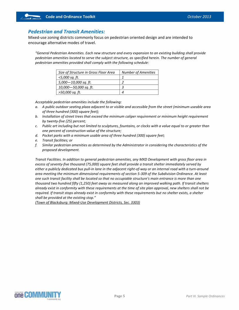
Code and Ordinance Toolkit October 2013
Page 5
Part III. Sample Ordinances
Pedestrian and Transit Amenities: Mixed-use zoning districts commonly focus on pedestrian oriented design and are intended to encourage alternative modes of travel.
“General Pedestrian Amenities. Each new structure and every expansion to an existing building shall provide pedestrian amenities located to serve the subject structure, as specified herein. The number of general pedestrian amenities provided shall comply with the following schedule:
Size of Structure in Gross Floor Area Number of Amenities <5,000 sq. ft. 1 5,000—10,000 sq. ft. 2 10,000—50,000 sq. ft. 3 >50,000 sq. ft. 4
Acceptable pedestrian amenities include the following: a. A public outdoor seating plaza adjacent to or visible and accessible from the street (minimum useable area
of three hundred (300) square feet); b. Installation of street trees that exceed the minimum caliper requirement or minimum height requirement
by twenty-five (25) percent; c. Public art including but not limited to sculptures, fountains, or clocks with a value equal to or greater than
one percent of construction value of the structure; d. Pocket parks with a minimum usable area of three hundred (300) square feet; e. Transit facilities; or f. Similar pedestrian amenities as determined by the Administrator in considering the characteristics of the
proposed development.
Transit Facilities. In addition to general pedestrian amenities, any MXD Development with gross floor area in excess of seventy-five thousand (75,000) square feet shall provide a transit shelter immediately served by either a publicly dedicated bus pull-in lane in the adjacent right-of-way or an internal road with a turn-around area meeting the minimum dimensional requirements of section 5-309 of the Subdivision Ordinance. At least one such transit facility shall be located so that no occupiable structure's main entrance is more than one thousand two hundred fifty (1,250) feet away as measured along an improved walking path. If transit shelters already exist in conformity with these requirements at the time of site plan approval, new shelters shall not be required. If transit stops already exist in conformity with these requirements but no shelter exists, a shelter shall be provided at the existing stop.” (Town of Blacksburg: Mixed-Use Development Districts, Sec. 3303)

Code and Ordinance Toolkit October 2013
Page 6
Part III. Sample Ordinances

Code and Ordinance Toolkit October 2013
Page 1
Part III. Sample Ordinances
Report 2:
Planned Zoning Districts
Planned districts allow for flexibility and creativity with the development process. These are zoning districts that essentially allow an applicant to design his/her own land use regulations and establish a development plan for a specific site. While planned districts offer flexibility, localities usually place a general framework of regulations to these types of development. Those regulations can set general standards on the mixture of uses, the amount of open space, building designs, road connectivity and other features of a development. Planned districts are increasingly popular throughout Virginia. Previously, these ordinances were only present in cities and urbanized counties, but even rural communities are beginning to adopt these zoning districts.
State Code Reference: Virginia Code Enabled §15.2-2201 The State Code defines planned unit development as:
“A form of development characterized by unified site design for a variety of housing types and densities, clustering of buildings, common open space, and a mix of building types and land uses in which project planning and density calculation are performed for the entire development rather than on an individual lot basis.”
Some localities follow an executive form of government, which influences planning authorities. This is addressed in Virginia Code §15.2-1216.
“Any county having an urban county executive or county executive form of government, or any county adjacent to any two or more such counties, may by ordinance require that the sellers of new homes provide to home buyers access to copies of … all development plans approved as part of the zoning for the planned unit development.”
Purpose: With a planned district, there should be a detailed link with neighborhood design which usually highlights mixed-use development. The purpose section should also make a strong link to the comprehensive plan or any other locally adopted planning documents. With a clearer definition of mixed-use development, developers and applicants will be held to the goals outlined in the comprehensive plans. This provides a clear understanding to those involved in a rezoning case that this district is intended to promote a mixed-use community that meets desirable planning principles.
“The PDH District is established to encourage innovative and creative design and to facilitate use of the most advantageous construction techniques in the development of land for residential and other selected secondary uses. The district regulations are designed to insure ample provision and efficient use of open space; to promote high standards in the layout, design and construction of residential development; to promote balanced developments of mixed housing types; to encourage the provision of dwellings within the means of families of low and moderate income; and otherwise to implement the stated purpose and intent of this Ordinance. To these ends, rezoning to and development under this district will be permitted only in accordance with a development plan prepared and approved in accordance with the provisions of Article 16.” (Fairfax County: Planned District, 6-101 Purpose and Intent)

Code and Ordinance Toolkit October 2013
Page 2
Part III. Sample Ordinances
“The planned development mixed use district is established to promote areas appropriate for office, retail, and residential uses, designed in a unified and cohesive manner in order to create an attractive environment in which to live, work and recreate. Two or more uses shall be integrated into a mixed use project. The district is appropriate in areas suitable for redevelopment as identified in the jumpstart plan contained within the comprehensive plan, and those areas designated for mixed use development to provide a process and design criteria that can be used to transition from established uses while accommodating new growth and evolving market trends. Vertical integration of uses is encouraged where appropriate. This district is considered an urban-style model with uses that are mixed together and easily walkable; for example, main entrances are located close to public streets, parking lots serve multiple uses, residential densities are higher to promote more activity within the development, as well as more public open spaces, and buffers located between different uses within the borders of the development are reduced or eliminated. The district shall promote a compact mixed-use design, traditional neighborhood pattern of development which includes a hierarchy of interconnected streets and blocks, pedestrian friendly walkable streets, a variety of housing types and lot sizes, mixed-use commercial neighborhood centers, and a connected passive and active open space network.” (City of Fredericksburg: Planned Development Mixed-Use District, Sec. 78-623. Purpose and intent)
“P-TND Planned - Traditional Neighborhood Development. The purpose of the P-TND is to provide areas of the county which are suitable for an approach to land-use planning and urban design that promotes the development or redevelopment of pedestrian-friendly neighborhoods with a mix of uses, housing types and prices, lot sizes and density, architectural variety, a central civic building and use, a network of streets and alleys that may include on-street parallel parking, and defined development edges.” (Stafford County: P-TND Planned – Traditional Neighborhood Development)
Link to Local Plans and Guides: The introductory section should tie the application of the zoning ordinance to the local comprehensive plan. There is validity in referencing other official guides and documents as well.
“The planned development shall substantially conform to the adopted comprehensive plan with respect to type, character, intensity of use and public facilities. Planned developments shall not exceed the density or intensity permitted by the adopted comprehensive plan, except as expressly permitted under the applicable density or intensity bonus provisions.” (Fairfax County, 16-101 General Standards)
“A final development plan shall be submitted and approved concurrently with the conceptual development plan for the proposed development. The conceptual and final development plan shall specify the uses and gross floor area for the proposed development and shall provide site and building designs that will integrate with the adjacent communities and complement existing and planned development by incorporating high standards of urban design. The plan shall also be in general accordance with any specific urban design concept and streetscape plans for the area including the provision of convenient and accessible pedestrian walkways and connections, all as set forth in the adopted comprehensive plan.” (Fairfax County: Planned Residential Mixed-Use District, 6-406 Use Limitations)
Defining Mixed-Use: In Virginia, there are several localities that provide detailed definitions and standards for the term “mixed-use.” A planned district can provide very detailed standards, even determining the percent distribution of uses on the site or within each building. While a development plan serves as the main guiding document for planned districts, these defined standards on mixed-use serve as the parameters
Code and Ordinance Toolkit October 2013
Page 3
Part III. Sample Ordinances
for an applicant’s proposed plan. A planned district may require that multi-story buildings have commercial uses on the first floor, with residential or office uses on the upper stories. These standards could apply to any urban corridor, where the form and use of the street-wall is particularly important. To allow for the flexibility intended for planned districts, the ordinance can allow for waivers to the required mix of uses.
“It is encouraged that the final development plan be submitted and approved concurrently with the conceptual development plan for all or a portion of the proposed development. The proposed development shall provide integrated site and building designs primarily incorporating a mix of uses within multiple story structures that will complement existing and planned development by incorporating high standards of urban design; shall be in accordance with any specific urban design concept and streetscape plans for the area including the provision of convenient and accessible pedestrian walkways and connections, all as set forth in the adopted comprehensive plan. To ensure consistency with the urban design guidelines for the Tysons Corner Urban Center, detailed streetscape, landscaping and building design plans, to include the location and height of rooftop features and amenities and the designation of the build-to lines, a phasing plan, if applicable, and a parking plan shall all accompany an application for a rezoning to the PTC District pursuant to Part 5 of Article 16.” (Fairfax County: Planned Tysons Corner Urban District, 6-505 Use Limitations)
“A PD-MU district shall contain the following standards: a) Commercial uses. At least 40 percent and no more than 65 percent of the gross land area of the district
shall be used to determine or compute the permitted floor area ratio in accordance with 78-626(2). In the case of vertically mixed use buildings, the commercial use on the ground floor shall be used to calculate this percentage.
b) Vertical mix. At least 20% of the buildings containing commercial uses within the district shall contain uses from at least two (2) different use categories. The applicable use categories are professional office, retail, and multifamily dwelling units above the first floor.
The PD-MU district requires a mix of uses based on the number of residential units as set forth in section 78-626(3) and commercial use expressed as a percentage as set forth in section 78-627(1)(a). The percentage shall mean the percentage of the total gross land area of the district subject to the rezoning application. The mix of uses under sections 78-626 and 78-627 shall be calculated in accordance with the following rules: a) The vertical stacking of residential uses in the same building as nonresidential uses is permitted. b) Phasing of the development may be approved at the time of rezoning. Each phase of development shall
contain a tabulation of the site by use category, the accumulated total FAR, total number of residential units and percentage open space to demonstrate that the development is in conformance with the GDP. Individual phases of the development may have densities that exceed the maximum or minimum requirements so long as such densities for the number of residential units or percentage of commercial use as shown on the GDP comply with the PD-MU district.
Notwithstanding any other provisions of this division the city council may adjust the percentage ratios for those uses set forth above.” (City of Fredericksburg: Planned Development Mixed-Use District, Sec. 78-627. Additional regulations)
“Residential uses shall be permitted in the PD-R district only in conjunction with one or more neighborhood commercial uses, unless authorized by the planning commission in accordance with the comprehensive plan. Neighborhood commercial uses. At least five percent but not more than 15 percent of the gross area of the PD-R development shall be devoted to neighborhood commercial uses. The neighborhood commercial uses must be provided in such a manner that they are accessible to both vehicles and pedestrians, with primary emphasis on the pedestrian circulation system. Such neighborhood commercial uses shall be located within a commercial or village center area and contain such uses as professional offices, specialty shops, hardware stores and other permitted uses, as listed in section 102-502.” (Fredericksburg: Planned Development Residential District, Sec. 78-414. Use limitations.)

Code and Ordinance Toolkit October 2013
Page 4
Part III. Sample Ordinances
“A. The proposed development will yield a minimum of one hundred thousand (100,000) square feet of gross floor space. B. The proposed development will be a logical extension of an existing P district, in which case it must yield a minimum of forty thousand (40,000) square feet of gross floor area.” (Spotsylvania County: Planned Development Commercial District, Sec. 23-6.23.6. Development standards)
Design Standards: While planned districts are intended to be flexible, a locality can require general design standards that will act as a framework for a proposed development plan. While rezoning cases include local discretion and negotiation, more detailed design guidelines give the locality greater leverage to implement goals from the comprehensive plan. These standards can apply to all planned districts or only to buildings that are adjacent to urban corridors. With this approach, a locality can better ensure that corridors consist of a main street design, rather than relying on developer to propose a desirable development plan.
“When located within the same building as residential uses, commercial and office uses shall be limited to the lowest two (2) floors.” (Fairfax County: Planned District, 6-106 Use Limitations)
“Structures exceeding 40 feet in height shall be set back from any single-family residential district a distance equal to a distance not less than one foot for each one foot of height in excess of 40 feet.” (City of Fredericksburg: Planned Development Mixed-Use District, Sec. 78-626. Bulk regulations)
“No application shall be approved for a planned development mixed use district under the provisions of this division unless the generalized development plan accompanying such application satisfies the following general standards and design criteria: 1. The development offers a variety of two or more of the following uses: commercial, residential, office; 2. The development consists of an orderly and creative arrangement of land uses, both in respect to each
other and to adjacent properties; 3. The application provides a comprehensive and integrated transportation system that separates pedestrian
and vehicular traffic, including roadways, bicycle paths, pedestrian walkways, and public transportation facilities, where applicable;
4. The application provides opportunities for cultural, educational, or recreational facilities for all segments of the development;
5. The site design and structures take advantage of their natural and manmade environment and to address sustainability.
6. The application provides for adequate public facilities; 7. The planned development substantially conforms to the comprehensive plan with respect to type,
character and intensity of use and public facilities; 8. The development does not hinder, deter or impede development of surrounding properties in accordance
with the comprehensive plan; 9. Sidewalks and other pedestrian pathways that link developed areas of the city and the proposed
development are in accordance with the comprehensive plan, zoning ordinance or deemed appropriate for the development;
10. The proposed land uses are recommend in the comprehensive plan or jumpstart plan as appropriate uses in the particular planning area in which the development is to be located; and
11. Where applicable, the development includes special provisions for the identification, restoration and preservation of buildings, structures, and sites which have historic, architectural, or archeological significance.
12. The buildings shall be designed and arranged in such a way as to promote energy efficiency through the design of environmentally friendly buildings utilizing environmentally sensitive guidelines such as those

Code and Ordinance Toolkit October 2013
Page 5
Part III. Sample Ordinances
published by the leadership in energy and environmental design through their green building rating system.
13. Landscaping and open space shall be used to provide shading, screening and erosion and sediment control. 14. The development shall reflect the existing natural topography of the site by preserving the natural
character and existing trees to the greatest extent possible.” (City of Fredericksburg: Planned Development Mixed-Use District, Sec. 78-628. General standards)
Standardized Sub-Areas: Some Virginia localities require that planned developments have multiple development types, or transects. For example, an ordinance may require that a planned district include multiple zones, chosen from a list of natural zone, rural zone, suburban zone, general urban zone, urban center zone, urban core zone or special districts. This approach avoids scenarios where developers propose planned developments with a uniform layout of a single use. With each sub-area or zone, the ordinance may set general development standards that apply to all proposals under that district. Other ordinances require that applicants break their proposals into land bays, which are subdivisions or units of a planned development application. There may be similar design guidelines that apply to different types of sub-areas, based on their location or orientation with critical roadways and adjacent sites.
“Planned-Traditional Neighborhood Development (P-TND). 1 Applicability. The regulations and provisions for P-TND, where permitted, by right or conditional use permit
in accordance with table 3.1, shall comply with this section. No use shall incorporate any of the regulations or provisions of this section unless reclassified as a P-TND district in accordance with this chapter.
2 Streets. a. The P-TND shall use the narrowest width of streets permitted to present the traditional town center
environment, reduce the speed of vehicles, and encourage pedestrian access through the P-TND. b. Refer to the traditional neighborhood development appendix to the comprehensive plan for specific
classification of streets within a development in the P-TND district. 4 Transect zones. The traditional neighborhood development (TND) shall comprise of all or some of the
following transect zones: a. T1, natural zone. Consists of lands approximating or reverting to a wilderness condition, including lands
unsuitable for settlement due to topography, hydrology or vegetation. This shall include all lands designated as critical resource protection area (CRPA), unless approved by the appropriate county, state, or federal offices to permit certain activities within the CRPA.
b. T2, rural zone. Consists of lands in open or cultivated state, or sparsely settled. These include woodlands, agricultural lands, grasslands, and regulated or dedicated athletic fields and golf courses.
c. T3, suburban zone. Consists of low-density suburban residential areas, differing by allowing home occupations. Planting is naturalistic with setbacks relatively deep. Blocks may be large and the roads irregular to accommodate natural conditions.
d. T4, general urban zone. Consists of a mixed use but primarily residential urban fabric. It has a wide range of building types: single, patio and townhouses. Setbacks and landscaping are variable. Streets typically define medium-sized blocks.
e. T5, urban center zone. Consists of higher-density mixed use building types that accommodate retail, offices, townhouses and multifamily. It has a tight network of streets with wide sidewalks, steady street tree planting and buildings set close to the frontages.
f. T6, urban core zone. Consists of the highest density, with the greatest variety of uses, and civic buildings of regional importance. It may have larger blocks; streets have steady street tree planting and buildings set close to the frontage.
g. SD-C, special districts-commercial. Consists of larger structures for commercial uses. The use may serve more than the development. The use may be appropriate when the development is in close proximity to a major transportation network. Proportion to scale between the height of the building and the street
Code and Ordinance Toolkit October 2013
Page 6
Part III. Sample Ordinances
should be taken into consideration. Such uses may require a larger scale of parking in which mitigation and the use of parking structures would be strongly encouraged.
8 Architectural standards in all transect zones. a. The exterior finish material on all facades, colors of balconies and porches, and material for fences along
the principal or side street line shall be determined by the approved neighborhood design standard. b. Flat roofs shall be enclosed by parapets a minimum of forty-two (42) inches high, or as required to
conceal mechanical equipment. c. Mechanical equipment, whether on the ground or the roof of a building shall be screened to where it is
not visible from any street. d. To maintain positive drainage of rainfall, all residential buildings, excluding multifamily units, shall have
pitched roofs and shall be symmetrically sloped no less than 5:12, except that porches and attached sheds may be no less than 2:12.”
(Stafford County: P-TND Planned – Traditional Neighborhood Development, Sec. 28-39. Special regulations) This ordinance includes land bays, which are subdivisions or units of a PUD application. This district includes design guidelines for architecture, streetscapes, parking, landscaping and open space – for town centers.
“Planned development districts shall be divided into land bays shown on the master zoning plan. Land bays shall be sequentially numbered or lettered. Land bays may contain more than one designation to achieve a mix of uses, but the designations shall be depicted and a list of uses identified to ensure compatibility with the land use classifications of the comprehensive plan and the purposes and objectives of this part. a. Residential land bays shall designate the uses and the standards found in Article III, and shall be
established in accordance with the following density ranges: - Areas of low density residential (one to four dwellings per acre) (LDR); - Areas of medium density residential (four to six dwellings per acre) (MDR); - Areas of high density residential (eight to 16 dwellings per acre) (HDR); - Areas of urban density residential (16 to 30 dwellings per acre) (UDR); and - Areas of urban high density residential (minimum of 31 dwellings per acre) (UHDR). b. Non-residential areas shall designate the uses and the standards, found in Article IV, and shall be
established in accordance with the following zoning districts: - B-1, General Business. - B-2, Neighborhood Business. - O(L), Office Low-Rise. - O(M), Office Mid-Rise. - O(H), Office High-Rise. - O/F, Office/Flex. - M-2, Light Industrial. c. Areas to remain as open space or conservation areas shall be labeled as such or may be incorporated into
a land bay as OS. Upon creation of a planned development district, uses permitted in each land bay shall be determined by its use designation, subject to any restrictions in the particular planned district regulations, the master zoning plan and any applicable proffers or special use permit conditions. The designation of permitted uses by land bay as required by subsections 1. and 2. above shall not be required in planned development districts approved prior to November 22, 1991, provided that if the owners shall substantially change the project from the approved in the original rezoning, the planning director may require that any application for amendment of the master zoning plan conform to the requirements of this part.” (Prince William County: Planned District Standards, Sec. 32-280.11. Land bay designations)

Code and Ordinance Toolkit October 2013
Page 7
Part III. Sample Ordinances
Impervious Surfaces: Most planned districts require that a set percentage of the development remain for open space or recreational purposes. Rather than focus on open space, some localities set percentages of site space for pervious services. Developers can meet these standards with parking lots, so long as there is pervious pavement. The focus is on water quality, rather than open space. While many planned district require open space, there are few standards on the quality of those areas.
“Coverage. Maximum coverage permitted of all impervious surfaces in any P-D district shall not exceed 50 percent of the total gross acreage. Areas used for swimming pools, bathhouses, tennis courts and other outside recreational space that is improved with a hard surface, to the extent that it does not exceed five percent of the gross acreage, shall not be counted as covered area. At least 20 percent of the gross tract area shall be in open space sections of at least 10,000 square feet each.” (City of Fairfax: P-D Planned Development District, Sec. 110-634)

Code and Ordinance Toolkit October 2013
Page 8
Part III. Sample Ordinances

Code and Ordinance Toolkit October 2013
Page 1
Part III. Sample Ordinances
Report 3:
Infill Ordinances
Infill development can be a critical piece of a comprehensive growth management strategy. For counties, infill and redevelopment can help ensure that designated development areas do not prematurely build out, which would otherwise place added development pressure on the surrounding rural areas. In cities, an infill ordinance can help to concentrate new construction in downtown areas or corridors, increasing the efficiency of transit and other services. In Virginia, there are relatively few examples of infill options in a zoning ordinance. While many urban or mixed-use districts may indirectly encourage redevelopment, there are only a handful of direct links. Due to the limited number of Virginia examples, this report includes samples from other states, along with resource materials to help find additional information on this topic.
Enabling Legislation: The Code of Virginia does not specifically address infill zoning options, but the authority to implement these ordinances would fall under the enabling legislation for zoning. § 15.2-2285, § 15.2-2286.
Purpose: There are several different approaches to infill zoning. The purpose language should define how infill development is encouraged by or related to the subsequent ordinance sections. A general purpose section could include:
“It is the general intent of this Ordinance to: (OTHER STATEMENTS OF INTENT MAY BE SUBSTITUTED HERE) 1) Accommodate growth in (NAME OF LOCAL JURISDICTION) by encouraging and facilitating new
development on vacant, bypassed and underutilized land within areas that already have infrastructure, utilities, and public facilities, while addressing the needs of (NAME OF JURISDICTION) residents.
2) Encourage efficient use of land and public services in the context of existing communities. 3) Stimulate economic investment and development in older established communities. 4) Provide developers and property owners flexibility so that they can achieve high quality design and
develop infill projects that strengthen existing communities. 5) Create a high quality community environment that is enhanced by a balanced compact mix of residential,
commercial, recreational, open space, employment and institutional uses and building types. 6) Implement the goals, objectives, and policies of the comprehensive plan, or the small area plan. 7) Improve approval certainty for infill development by providing clear development standards. 8) Encourage compact development that is pedestrian-scaled and, if applicable, transit-oriented.“ (Maryland Department of Planning: Models and Guidelines for Infill Development)
Code and Ordinance Toolkit October 2013
Page 2
Part III. Sample Ordinances
Other zoning districts may not be directly tied to infill or redevelopment, but could still help encourage this type of development. With language on this topic, infill can be a component to approving a zoning map amendment.
“The mixed use (MU) district creates a flexible approach to development, to include infill and redevelopment, by allowing a variety of interrelated and compatible commercial, office, residential, civic, recreational, and entertainment uses in a pedestrian-oriented neighborhood setting based on, but not limited to the following principles: (1) Connectivity of road networks, including connectivity of new local streets with existing local streets; (2) Connected pedestrian networks and pedestrian-friendly road design; (3) Reduced front and side yard building setbacks; (4) Mixed-use neighborhoods, including mixed housing types; and (5) Respects the character of adjacent properties and surrounding neighborhoods.” (Spotsylvania County: Mixed-Use District, Sec. 23-6.28.1)
Definitions: The definitions for infill development can be brief, as seen with these examples from the Cities of Norfolk and Austin.
“Infill means utilization of vacant land in previously developed areas.” (City of Norfolk: Chesapeake Bay Preservation Area Overlay District, Sec. 11-2.2)
“Infill refers to “filling in” vacant or underutilized parcels of land in existing developed areas.” (City of Austin, Texas: Special Use Infill Options and Design Tools)
Application: There are several different approaches to infill zoning. A locality can require a special use permit for infill options. For more information on this example from Austin, refer to this online report that the City developed to provide guidance on infill strategies ftp://ftp.ci.austin.tx.us/npzd/Austingo/infill_tools.pdf.
“During the neighborhood planning process, a neighborhood may recommend approval of one or more of the Special Uses. Some of the uses may be applied to the entire neighborhood planning area or portions of it (sub-districts), whereas others must be applied to specific properties. The chosen Special Uses will be incorporated into a single zoning overlay known as the ‘Neighborhood Plan Combining District’ This combining district requires approval from the City Council.” (City of Austin, Texas: Special Use Infill Options and Design Tools)
A zoning ordinance can establish a range of districts, such as Residential R-1 through R-20, where high level districts allow for additional uses and densities. The ordinance can target those high level districts for infill development, providing incentives to redevelop select sites in zoning map amendments.
“The purpose of the A-12 and A-18 Apartment Districts is to provide areas for various multiple-family housing types at a variety of densities, in areas where public facilities are adequate to support these densities, and to provide for certain other necessary and related uses within multi-family communities but limited as to maintain compatibility with residential uses. The A-24 and A-36 Apartment Districts are created in recognition of the existence of developed areas where multifamily dwellings exist at densities between twenty-four (24) and thirty-six (36) dwelling units per acre. It is not the intention to create additional A-24 or A-36 Districts or to

Code and Ordinance Toolkit October 2013
Page 3
Part III. Sample Ordinances
enlarge the limits of existing A-24 or A-36 Districts except in cases to promote infilling in areas that are already zoned or developed at densities between twenty-four (24) and thirty-six (36) dwelling units per acre.” (Virginia Beach: Apartment Districts, Sec. 600)
The zoning ordinance can also address infill development with the use of overlay zoning districts. With the overlay approach, the underlying zoning district would still apply, but there would be additional standards, incentives or options focused on infill and redevelopment.
“An overlay zone allows jurisdictions to target particular areas for infill without rewriting entire zoning categories. Parcels affected by an overlay zone are subject to the rules of the underlying zone, in addition to the rules of the overlay zone. This approach is commonly used in Maryland to protect historic or environmentally sensitive areas, viewsheds, and the Chesapeake Bay Critical Area. The practical effect of the overlay regulations varies by local preference: the overlay may modify or eliminate existing regulations, or it may introduce new regulations. Potential conflicts may arise between the underlying zone and the overlay zone. One way to address this is to add a clause to the ordinance that states, ‘in the case of conflict among regulations, the more flexible standard shall apply.’ This rule is premised on the policy that infill rules should permit flexibility. (In these models and guidelines, a boundary-specific infill overlay zone provides flexibility for infill development in existing communities without changing or rewriting the existing zoning code.)” (Maryland Department of Planning: Models and Guidelines for Infill Development)
Development Standards: Design or development standards should be part of an infill zoning approach. These standards help to ensure that a development project truly meets the intention of the ordinance and local vision. The following is a sample ordinance from the Maryland Department of Planning. This sample shows how a locality can address topics such as density, along with building bulk and arrangement on a site.
“General: Density, design, materials, use and scale should reflect local style, climate, heritage and materials unique to (NAME OF LOCAL JURISDICTION). (1) Density: may exceed the underlying zone (BY xx UNITS PER ACRE) for the purpose of creating a
neighborhood having a variety of housing types. (a) Total number of dwelling units as well as location to be established at the time of preliminary plan
approval. (b) Lot Size. Lot areas established in the preliminary plan shall be dependent on proposed densities, floor
area ratios, setbacks, building heights and community compatibility. (i) Existing Small Lot Amnesty. A legal lot of record that existed prior to the date of this ordinance may
use Infill Ordinance minimum buildable lot standards. (ii) Minimum Buildable Lot Standards. See sample Ordinance language in Appendix B.
(2) Building Height. (a) Buildings restricted to (X) stories or (XX) feet in height, or the average of adjacent buildings.
(i) Heights allowed by right or by special exception in the underlying zone. (ii) If greater than the allowed maximum, the proposed building or structure must meet the following
criteria for community compatibility: 1. Neighborhood scale 2. Privacy 3. Light and shadow 4. Views 5. Architectural compatibility
(3) Building Setback. (a) Setbacks as allowed by right in the underlying zone. (b) Contextual setback option. May use an average of the setbacks of adjacent or abutting lots.

Code and Ordinance Toolkit October 2013
Page 4
Part III. Sample Ordinances
(4) Bulk and Scale shall be similar to and consistent with the surrounding neighborhood as evaluated by the bulk of buildings adjacent, abutting and surrounding the proposed development. Larger buildings should be designed to adhere to the existing architectural pattern of the surrounding neighborhood.
(5) Flexible development standards to reduce lot areas, widths and yards and to increase building heights may be permitted for infill developments at the discretion of the approving agency(s), subject to proof of good cause and benefit to the development and community, to encourage a variety of land uses, and to address difficult sites which incorporate infill and redevelopment or rehabilitation. Building height and coverage may vary so long as the project average is consistent with the neighborhood scale and architectural rhythm and does not constitute a disruptive condition in the identity of the area (See Section 5).”
(Maryland Department of Planning: Models and Guidelines for Infill Development) These examples from the City of Roanoke and Norfolk serve as example of how to address setbacks with infill developments.
“Where indicated as applicable in Section 36.2-312, the following regulations shall be used to determine the minimum and maximum front yard to be provided.
Where the shallowest established front yard is between the minimum and maximum front yards of the district Minimum yard: depth of the shallowest established front yard Maximum yard: depth of the shallowest established front yard, plus 5 feet
Where the shallowest established front yard is deeper than the district's maximum front yard Minimum yard: same as district Maximum yard: depth of shallowest established front yard
Where the shallowest established front yard is shallower than the district's minimum front yard Minimum yard: depth of the shallowest established front yard Maximum yard: depth of the shallowest established front yard, plus 10 feet
Where the shallowest established front yard is less than 10 feet Minimum yard: depth of the shallowest established front yard Maximum yard: 20 feet
Where the shallowest established front yard is established by an existing building on the lot where an unenclosed front porch addition is proposed Minimum yard: depth of the shallowest established front yard, minus 10 feet, but no closer than the district minimum Maximum: not applicable
Where the lot has frontage on a cul-de-sac, regardless of the presence of buildings on adjoining lots Minimum: same as district minimum Maximum: same as district maximum
Where the adjoining structure has its primary facade on a different street frontage and there are no structures on other adjoining lots fronting on the same street Minimum: same as district minimum Maximum: same as district maximum”
(City of Roanoke: Residential Districts, Sec. 36.2-313)
“Where the new construction is infill development on a zoning lot between two existing buildings, the front yard requirement for the new construction may match the existing yards for the adjacent buildings or may be the average of the existing yards of the adjacent buildings, whichever is applicable. Where the infill development occurs on a corner lot, the building immediately across the street shall be considered an adjacent building for determining the front yard requirement.” (City of Norfolk: Chapter 6, Commercial Districts)

Code and Ordinance Toolkit October 2013
Page 5
Part III. Sample Ordinances
Additional Resources: There are additional sources that provide guidance on these zoning options. The following sources provide extensive material on model ordinances, development review procedures and the benefits of infill development. City of Austin, Texas Special Use Infill Options and Design Tools Available Through the Neighborhood Plan Combining District (NPCD), October 2012 ftp://ftp.ci.austin.tx.us/npzd/Austingo/infill_tools.pdf Maryland Department of Planning Models and Guidelines for Infill Development October 2001 http://planning.maryland.gov/pdf/ourproducts/publications/modelsguidelines/infillfinal_1.pdf

Code and Ordinance Toolkit October 2013
Page 6
Part III. Sample Ordinances

Code and Ordinance Toolkit October 2013
Page 1
Part III. Sample Ordinances
Report 4:
Rural Design Standards
Rural Design is a term that may include nearly endless topics or ideas. This discussion may include concepts such as rural preservation, clustered development/open space, forestal zones, heritage /historic preservation and many other themes. This report instead focuses on development standards for commercial (non-agricultural) operations in rural areas. These operations may include lodging, retail, restaurants or other businesses found in small crossroad communities. While proper growth management diverts most commercial development into designated growth areas, there may still be a need to allow for limited services in rural parts of the community, to serve those residents outside of the urbanized areas. In Virginia, there are few examples of development standards for businesses in rural areas. Loudon County provides the most comprehensive model for this topic. Samples from that ordinance are included below.
Enabling Legislation: Virginia Code Enabled Sections 15.2-2200, 15.2-2283 and 15.2-2284
� Preserve agricultural and forestal land, along with the values of properties; � Facilitate the creation of a convenient, attractive and harmonious community; � Protect against destruction of or encroachment upon historic areas.
Purpose: This example from Loudon County shows how a locality can set a clear purpose or objective to rural development standards.
“The purpose of this section is to allow residents in the AR-1, AR-2, A-3, A-10, TR, CR, JLMA, PD-RV and PD-CV districts to locate and operate small-scale service and contracting businesses or lease such businesses, which preserve the rural and historic character of the districts and agriculture as an industry. It is the general intent of this Ordinance that commercial uses locate in and around existing urban areas that have adequate roads, public facilities and utilities. However, some small businesses may locate within these districts in order to provide economical and convenient services to the rural area, to supplement farming as a source of income and to operate a home-based business where feasible. Some small businesses can operate in the rural areas with special designs and conditions” (Loudon County: Small Businesses, Section 5-614)

Code and Ordinance Toolkit October 2013
Page 2
Part III. Sample Ordinances
Definitions: Design standards for rural development may include a list of additional definitions. If the ordinance includes specific development standards, then there should be clear definitions for those types of land uses and businesses that are affected by these regulations.
“Rural Corporate Retreat: A use, compatible with agriculture, horticulture, animal husbandry, open space and/or historic preservation, which is engaged in the study, testing, design, invention, evaluation, or development of technologies, techniques, processes, or professional and consulting services, and education and training related to such advances and services. Rural Corporate Retreats may be utilized for basic and applied research services and education wherein the inquiry process is conducted in a manner similar to that of institutions of higher learning or management consulting firms. Rural Corporate Retreat facilities may include facilities for associated training programs, seminars, conference, and related activities.
Rural Economy Lot: A type of lot located with an AR-1 or AR-2 District cluster subdivision. A minimum of one Rural Economy Lot is required to be located within any AR-1 or AR-2 cluster subdivision. The primary use of such lot is for rural economy uses, with residential uses permitted in association with a rural economy use
Rural Economy Uses: An array of agricultural and equine enterprises, tourist attractions and services, and commercial businesses that are land-based, depend on large tracts of open land, and the area’s rural atmosphere.
Rural recreational establishment, outdoor: Any establishment operated as a commercial enterprise in which seasonal facilities directly related to outdoor recreation are provided for all or any of the following: camping, skating rink (outdoor), lodging, picnicking, boating, fishing, swimming, outdoor games and sports, animal-mounted trail riding, and activities incidental and related to the foregoing. This use may include a refreshment stand as an accessory use. Nothing in this definition shall be construed to mean a track for motorized vehicles of any type, however defined.
Rural Resort/Rural Retreat: A private establishment consisting of a detached structure or structures located in a rural setting in which lodging units are offered to transients for compensation as the principal use, along with conference and meeting facilities, restaurant and banquet facilities, and recreational amenities.
Rural Village Commercial Area: Land within the Rural Village Center designated primarily for commercial, apartment and civic uses on the Concept Development Plan.” (Loudon County: Definitions, Article 8)
Application: The Loudon County ordinance sets limits on the acreage and operations of businesses that are located in the rural areas.
“Small Business Site Development Criteria. (1) Standards and Restrictions for Small Business Uses.”
Acreage No. of Employees
Heavy Equip. (On-Site)
Business Vehicles (On-Site)
(a) 0-3 1 maximum none 2 maximum (b) 3 but <10 3 maximum none 2 maximum (c) 10 but <50 4 maximum 2 maximum 4 maximum (d) 50 or greater 10 maximum 5 maximum 6 maximum
(Loudon County: Small Businesses, Section 5-614)

Code and Ordinance Toolkit October 2013
Page 3
Part III. Sample Ordinances
“Additional Standards for AR and TR Districts. In the AR and TR districts, rural retreats and resorts shall comply with the following additional requirements in addition to the general standards identified above. Where there is a conflict between these standards and the general standards controlling the development of rural resorts and retreats, these standards shall control.
Intensity/Character. The minimum lot area shall be as follows.”
Use Size of Lot (Minimum)
Nos. of Guest Rooms
Level I – Rural Retreat small scale
40 acres Up to 20 rooms
Level II – Rural Retreat medium scale
60 acres 21-40 rooms
Level III –Rural Retreat large scale
80 acres 41-60 rooms
Level I – Rural Resort small scale
100 acres 61-80 rooms
Level II – Rural Resort medium scale
120 acres 81-100 rooms
Level III –Rural resort large scale
150 acres 101-120 rooms
More than 120 rooms requires special exception approval pursuant to Section 6-1300
(Loudon County: Bed and Breakfast and Rural Guest Establishments, Section 5-601) There are additional standards placed on storage areas, to ensure that outside materials and equipment are shielded from view.
“Storage yards shall be screened consistent with the requirements of Section 5-653(C) (Screening of Outdoor Storage and Storage Yards). Outdoor storage space must be enclosed on all sides by a fence…Outdoor storage and storage yards shall be screened to minimize visibility from adjacent public roads and adjacent single family detached uses by six (6) canopy trees per one hundred (100) lineal feet of perimeter of storage area. ” (Loudon County: Small Businesses, Section 5-614)
Loudon County includes additional parking and landscaping requirements for those businesses in rural areas.
“Parking areas shall be provided with 1 canopy tree per each 10 parking or 2 loading spaces for off-street parking areas and service areas for loading and unloading. The Zoning Administrator may waive, reduce and/or modify these tree planting requirements if in his/her opinion the topography or existing vegetation adequately screens such parking areas from adjacent properties.” (Loudon County: Landscaping Standards for Specific Uses, Section 5-653)

Code and Ordinance Toolkit October 2013
Page 4
Part III. Sample Ordinances
Hanover County established additional development standards for residential subdivisions located in rural areas.
“Additional requirements for subdivision. The following additional development standards shall be required for Rural Cluster subdivisions: 1. All floodplains, wetlands, and steep slopes shall be protected from clearing, grading, filling, or construction
(except as may be approved by the County for essential infrastructure). 2. Lots shall be designed to preserve and maintain existing treelines between fields or meadows, pastures,
meadows, orchards, and mature woodlands, especially those containing a significant wildlife habitat. 3. Lots shall be designed to minimize development on open fields and pastures, and should locate building
sites on the least prime agricultural lands. 4. Existing views from public thoroughfares shall be preserved to the maximum extent practicable. 5. Lots shall be designed to minimize necessary grading or filling, and to take advantage of the existing
topography and landforms to the extent practicable. 6. Lots shall be designed to avoid important historic, archaeological, or cultural sites.” (Hanover County: Rural Cluster Subdivisions, Section 26-30)
Corridor design standards or guidelines may address rural areas, as seen in these examples from Spotsylvania and Montgomery counties.
“Rural development HCOD. The rural development HCOD designation was established in areas where existing and future development demands are expected to be low as the county grows. These are areas that are more rural in character and as such design guidelines have been developed to complement and preserve that character in the rural HCOD. Generally the rural HCOD has been established within the agricultural/rural districts of the county.” (Spotsylvania County: Highway Corridor Overlay District, Sec. 23-7.6.4)
“Purpose. The purpose of the Route 177 Corridor Overlay District is to establish a base development standard applicable across all pre-existing zoning districts. The uses present within the district may be agricultural, residential, commercial or industrial. The regulations for this district are designed to stabilize and protect the essential characteristics of the district, while allowing well planned residential, commercial, and industrial development. The specific objectives of the district regulations are to: promote and encourage safe and efficient traffic movement, protect existing residential communities from conflicting land uses, encourage planned unit development of community facilities, minimize visual nuisances associated with increased intensities of land use, and protect the natural environment.” (Montgomery County: Route 177 Corridor Overlay District, Sec. 10-39)

Code and Ordinance Toolkit October 2013
Page 1
Part III. Sample Ordinances
Report 5:
Transfer of Development Rights (TDRs)
A transfer of development right (TDR) program serves as a tool to divert development from one area (“sending zoning”) to other areas that the locality targets for higher density development (“receiving zones”). This program allows for financial incentives to property owners to send or receive these development rights. The Virginia General Assembly first enabled TDRs in 2006, but made subsequent amendments that addressed obstacles to local implementation. While these programs are present across the country, Frederick County serves as the only established example in Virginia. Note: TDR programs usually are not applicable to cities, particularly cities with a smaller landmass.
Enabling Legislation: Virginia Code Enabled §15.2-2316.2 Selected Requirements:
� Any proposed transfer of development rights shall only be initiated upon application by the property owners.
� The locality may, by ordinance, designate receiving and sending areas. � The property owner who transfers his/her development rights can make application to the
locality for a real estate tax abatement that lasts for a period of up to 25 years, to compensate the owner.
Purpose: The purpose section outlines the intent of the program and helps to provide a strong legal foundation for the ordinance.
“The purpose of the TDR program is to provide a mechanism by which a property owner can transfer residential density from sending areas to receiving areas and/or to a transferee without relation to any particular property through a voluntary process intended to permanently conserve agricultural and forestry uses of lands, reduce development densities on those and other lands, and preserve rural open spaces and natural and scenic resources. The TDR program is intended to complement and supplement county land use regulations, resource protection efforts, and open space acquisition programs. The TDR program is intended to encourage increased residential density in areas that can better accommodate this growth with less impact on public services and natural resources.” (Stafford County: Transfer of Development Rights, Sec. 28-354. Purpose)
“Pursuant to the authority granted by §§ 15.2-2316.1 and 15.2-2316.2 of the Code of Virginia, there is established a transfer of development rights (TDR) program, the purpose of which is to transfer residential density from eligible sending areas to eligible receiving areas and/or transferee through a voluntary process for permanently conserving agricultural and forestry uses of lands and preserving rural open spaces, and natural and scenic resources. The TDR program is intended to supplement land use regulations, resource protection efforts and open space acquisition programs and encourage increased residential density where it can best be accommodated with the least impacts on the natural environment and public services by: A. Providing an effective and predictable incentive process for property owners of rural and agricultural land
to preserve lands with a public benefit; and

Code and Ordinance Toolkit October 2013
Page 2
Part III. Sample Ordinances
B. Implementing the Comprehensive Policy Plan by directing residential land uses to the Urban Development Area (UDA); and
C. Providing an efficient and streamlined administrative review system to ensure that transfers of development rights to receiving areas are processed in a timely way and balanced with other county goals and policies and are adjusted to the specific conditions of each receiving area.
(Frederick County: Transfer of Development Rights, Sec. 165-301.01. Purpose)
Definitions: There are several key definitions associated with a TDR program. The three primary definitions include:
“Receiving area – means one or more areas identified by an ordinance and designated by the comprehensive plan as an area authorized to receive development rights transferred from a sending area.
Sending area – means one or more areas identified by an ordinance and designated by the comprehensive plan as an area from which development rights are authorized to be severed and transferred to a receiving area.
Transfer of development rights – means the process by which development rights from a sending property are affixed to one or more receiving properties.” (Code of Virginia: § 15.2-2316.1. Definitions)
Application: TDR programs can be complicated to administer. The locality must track development rights, along with the sending and receiving areas. The zoning ordinance may require substantial revisions to accommodate the TDR program. The locality must also establish instruments for recording the transfer for developments. These efforts may require additional staff and result in costs to the locality, but the benefit is a tool for preserving specified areas from development. A full list of considerations for implementation includes:
1. “The issuance and recordation of the instruments necessary to sever development rights from the sending property, to convey development rights to one or more parties, or to affix development rights to one or more receiving properties. These instruments shall be executed by the property owners of the development rights being transferred, and any lien holders of such property owners. The instruments shall identify the development rights being severed, and the sending properties or the receiving properties, as applicable;
2. Assurance that the prohibitions against the use and development of the sending property shall bind the landowner and every successor in interest to the landowner;
3. The severance of transferable development rights from the sending property; 4. The purchase, sale, exchange, or other conveyance of transferable development rights, after severance,
and prior to the rights being affixed to a receiving property; 5. A system for monitoring the severance, ownership, assignment, and transfer of transferable development
rights; 6. A map or other description of areas designated as sending and receiving areas for the transfer of
development rights between properties; 7. The identification of parcels, if any, within a receiving area that are inappropriate as receiving properties; 8. The permitted uses and the maximum increases in density in the receiving area; 9. The minimum acreage of a sending property and the minimum reduction in density of the sending
property that may be conveyed in severance or transfer of development rights; 10. The development rights permitted to be attached in the receiving areas shall be equal to or greater than
the development rights permitted to be severed from the sending areas; 11. An assessment of the infrastructure in the receiving area that identifies the ability of the area to accept
increases in density and its plans to provide necessary utility services within any designated receiving area; and

Code and Ordinance Toolkit October 2013
Page 3
Part III. Sample Ordinances
12. The application to be deemed approved upon the determination of compliance with the ordinance by the agent of the planning commission, or other agent designated by the locality.”
(Code of Virginia: § 15.2-2316.2. Localities may provide for transfer of development rights.)
Comprehensive Plan: With a TDR program, the locality must also make amendments to its comprehensive plan. The State Code requires that there be a map of the sending and receiving areas, incorporated into the comprehensive plan.
Regional Application: In 2007, the General Assembly amended the enabling legislation to allow for TDR programs that span county-city boundaries. With this option, a county and adjoining city may apply an agreement that allows for the transfer of development rights from the county (sending zones) to the city (receiving zones).
“Any county and an adjacent city may enter voluntarily into an agreement to permit the county to designate eligible receiving areas in the city if the governing body of the city has also amended its zoning ordinance to designate the same areas as eligible to receive density being transferred from sending areas in the county. The city council shall designate areas it deems suitable as receiving areas and shall designate the maximum increases in density in each such receiving area. “ (Code of Virginia: § 15.2-2316.2. Localities may provide for transfer of development rights.)
Additional Resources: In 2010, the Virginia Department of Agriculture and Consumer Services completed a model ordinance for Virginia localities (A Model Transfer of Development Rights Ordinance for Virginia Localities). This document provides a detailed step-by-step process for establishing a TDR program. For a copy of that report, please contact VDACS or go online to: http://www.vdacs.virginia.gov/preservation/pdf/Model%20TDR%20Ordinance.pdf. This report provides additional references to guidance related to TDR program. That list includes:
� Report: The Feasibility of Successful TDR Programs for Maryland’s Eastern Shore, prepared by the Eastern Shore Land Conservancy, Inc. (January 2007) http://agroecol.umd.edu/files/Dehart%20Full%20Report%20HRHCAE%20Pub-2007-01.pdf
� Beyond Takings and Givings: Saving Natural Areas, Farmland, and Historic Landmarks with
Transfer of Development Rights and Density Transfer Charges, by Rick Pruetz, FAICP http://www.beyondtakingsandgivings.com/
� TDR Case Studies by Rick Pruetz: http://www.beyondtakingsandgivings.com/updates.htm
� American Planning Association, Model Transfer of Development Rights Ordinance
http://www.planning.org/growingsmart/guidebook/nine02.htm#9401
� Preserving property: Transfer of development rights saves natural and historic sites, (Commercial Investment Real Estate, Mar./Apr. 2006). http://www.ciremagazine.com/article.php?article_id=915

Code and Ordinance Toolkit October 2013
Page 4
Part III. Sample Ordinances
� Transfer of development rights, (1000 Friends of Minnesota Fact Sheet #5, June 12, 2003). http://www.1000fom.org/library/fact-sheets/5
� Transfer of development rights: Fact sheet, (American Farmland Trust -Farmland Information
Center, Jan. 2001). http://www.farmlandinfo.org/
� Making markets for development rights work: what determines demand?, (Resources for the Future, Oct. 2005). http://www.rff.org/documents/RFF-DP-05-45.pdf
� Transfer of Development Rights in U.S. Communities: Evaluating Program Design,
Implementation, and Outcomes (Resources for the Future, 2007) http://www.rff.org/Publications/Pages/PublicationDetails.aspx?PublicationID=9578
� Transfer of Development Rights, Capitol Region Council of Governments Best Practices Manual,
Chapter 3. http://www.crcog.org/publications/CommDevDocs/TCSP/Ch03_FactSheet_TDR.pdf

Code and Ordinance Toolkit October 2013
Page 1
Part III. Sample Ordinances
Report 6:
Impact Fees
Impact fees are charges on new development, intended to recover costs for new transportation infrastructure that is needed to serve private development. The fees apply to all development within a defined impact fee service area. A locality can assess the fee to residential, commercial or industrial development. In Virginia, there is limited use of impact fees. Culpeper County adopted an impact fees program in 2010, but its Board of Supervisors repealed that ordinance two years later. Currently, Stafford County is the only locality in Commonwealth that has an adopted program.
Enabling Legislation: Virginia Code Enabled § 15.2-2319 Selected Requirements:
� The locality shall establish an impact fee advisory committee, to assist and advise the governing body with regard to the ordinance.
� The locality establishes one or more impact fee service areas within its comprehensive plan. Impact fees collected from new development within an impact fee service area are expended for road improvements benefiting that area. (§ 15.2-2320)
� The locality conducts an assessment of road improvement needs benefiting an impact fee service area and adopts a road improvements plan. (§ 15.2-2321)
Purpose: Since there is only one impact fee program in Virginia, Stafford County offers the lone example of a purpose section. In item (c) It defines when the impact fees apply.
(a) “This article shall be known and may be cited as the ‘Road Impact Fee Ordinance.’ (b) The board of supervisors has the authority to adopt this article pursuant to Code of Virginia, §
15.2-2317 et seq. (c) Except as specifically provided herein, this article shall apply, upon the effective date, May 21,
2014, to new development of all land contained in the designated impact fee service area in Stafford County to generate revenue to fund or recover the costs of reasonable road improvements benefitting new development.”
(Stafford County: Impact Fees, Sec. 13.5-1)
Definitions: An impact fee ordinance should include the basic, essential definitions. At a minimum, it should define applicable costs and road improvements that are eligible for the collected funds. The ordinance should also define the terms impact fee and service area.
(a) “Cost includes, those expenses attributable to completion of road improvement projects, in addition to all labor, materials, machinery, and equipment for construction: (i) acquisition of land, rights-of-way, property rights, easements, and interests, including the cost of moving or relocating utilities; (ii) demolition or removal of any structure on land so acquired, including acquisition of land to which such structure may

Code and Ordinance Toolkit October 2013
Page 2
Part III. Sample Ordinances
be moved; (iii) survey, engineering, environmental, archeological, and architectural expenses; (iv) legal, administrative, and other related expenses; and (v) interest charges and other financing costs if impact fees are used for the payment of principal and interest on bonds, notes, or other obligations issued by the county to finance the road improvement.
(b) Impact fee means a charge or assessment imposed against new development located within the designated impact fee service area in order to generate revenue to fund or recover the costs of reasonable road improvements benefiting the new development in said area. Impact fees may not be assessed and imposed for road repair, operation, and maintenance, nor to expand existing roads to meet demand which existed prior to the new development.
(c) Impact fee service area means land designated within this article and the comprehensive plan of the county, having clearly defined boundaries and clearly related traffic needs and within which development is to be subject to the assessment of impact fees.
(d) Road improvement includes construction of new roads or improvement or expansion of existing roads and related appurtenances as required by applicable construction standards of the Virginia Department of Transportation, or the applicable standards of the county, to meet increased demand attributable to new development. Road improvements do not include on-site construction of roads that a developer may be required to provide.” (Stafford County: Impact Fees, Sec. 13.5-2. Definitions)
Application: In order to enact an impact fee program, the locality must first include specific provisions in its comprehensive plan. The plan must establish at least one impact fee service area that has clear boundaries and related traffic needs within the defined area. Any fees collected within a service area must be assigned to transportation projects within that area. The locality can establish a service area that encompasses its entire landmass, except for specific areas that are excluded.
“There is hereby established a road impact fee service area that encompasses all land located in the county, except any land located within the boundary of Marine Corps Base Quantico, as shown within the county's comprehensive plan.” (Stafford County: Impact Fees, Sec. 13.5-4. Road impact service area)
Prior to adopting a system of impact fees, the locality must conduct an assessment of road improvement needs. There must be a road improvements plan for the area, which is usually part of the comprehensive plan. A locality can overlap their development and service areas, so that the funds will serve the highest growth areas, where there is greater need for services. Localities can also choose to define their non-development areas as their impact fee service area. The rationale behind this approach is to provide further financial incentives that channel future growth into the established development areas. An impact fee program also requires several amendments to the local codes. Local ordinances set the fee schedule. The ordinance must specify that fees are collected with issuance of a building permit.
(a) “The amount of the road impact fee shall be determined by the schedule attached to this article as Exhibit B ("Road Improvements Plan and Road Impact Fees"), dated January 2013, which is incorporated herein by reference.
(b) The road impact fee schedule has been calculated using the road impact fee project list identified in chapter 4 of the comprehensive plan and attached at the end of this article as Exhibit A (Road Impact Fee Project List), dated June 2012, which is incorporated herein by reference.
(c) The amount of road impact fees to be imposed for a specific project, development, or subdivision shall be determined as provided by the schedule before or at the time the subdivision plat or site plan/construction plan is approved.”

Code and Ordinance Toolkit October 2013
Page 3
Part III. Sample Ordinances
(Stafford County: Impact Fees, Sec. 13.5-5. Road impact fee schedule)
“Road impact fees shall be paid in full to the county at the time of issuance of a building permit unless the county administrator has agreed to accept installment payments at a reasonable rate of interest for a fixed number of years.” (Stafford County: Impact Fees, Sec. 13.5-6. When road impact fees to be paid)
The ordinance must provide for appeals from administrative determinations, regarding the impact fees to be imposed, to the governing body or such other body as designated in the ordinance.
(a) “The county shall refund any road impact fee, or portion thereof, for which construction of a project is not completed within a reasonable period of time, not to exceed fifteen (15) years. In the event that impact fees are not committed to road improvements benefiting the impact fee service area within seven (7) years from the date of collection, the county may commit any such impact fees to the secondary or urban system construction program of the county for road improvements that benefit the impact fee service area.
(b) Upon completion of a project included in the road improvement plan, the county shall recalculate the road impact fee based on the actual cost of the improvements. The county shall refund any difference if the road impact fee exceeds the actual costs by more than fifteen (15) percent.
(c) Any refunds shall be made to the record owner of the property at the time the refund is made.” (Stafford County: Impact Fees, Sec. 13.5-10. Refund of road impact fees)
The ordinance must establish an advisory Committee, which serves an advisory capacity to the local elected board. Amendments also set credits for the value of any dedication, contribution or construction from the developer for off-site road or other transportation improvements benefiting the impact fee service area.
“The value, as calculated according to the county impact fee policy, of any dedication, contribution, or construction from the developer for off-site road or other transportation improvements benefiting the impact fee service area shall be treated as a credit against the impact fees imposed on the developer's project. The county shall treat as a credit any off-site transportation dedication, contribution, or construction, whether it is a condition of a rezoning or otherwise committed to the county.
The county also shall calculate and credit against impact fees the extent to which: (i) other developments have already contributed to the cost of existing roads which will benefit the development; (ii) new development will contribute to the cost of existing roads; and (iii) new development will contribute to the cost of road improvements in the future other than through impact fees, including any special taxing districts, special assessments, or community development authorities.
The county may employ the transportation fund to complete road impact fee projects and credit the road impact fee trust fund for these expenses.” (Stafford County: Impact Fees, Sec. 13.5-7. Credits against road impact fees)

Code and Ordinance Toolkit October 2013
Page 4
Part III. Sample Ordinances
Benefits of the Ordinance: Impact fees apply to all development, whereas the City’s and County’s existing proffer policies only apply to rezoning cases. With impact fees, the funds are deposited into an interest-bearing account that is established for the impact fee service area. Interest earned on deposits shall become funds of the account.
(a) “There is established a road impact fee trust fund for the impact fee service area established under section 13.5-4 and designated within the county's comprehensive plan.
(b) All funds collected through road impact fees shall be deposited in an interest-bearing account for the benefit of the impact fee service area. Interest earned on each deposit shall become funds of the account.
(c) The expenditure of funds from the account shall be only for road improvements benefitting the designated impact fee service area as set forth in this article.”
(Stafford County: Impact Fee, Sec. 13.5-9. Road impact fee trust fund)
Disadvantages: An impact fee program can be difficult to manage and there are limits to what the program can finance. The locality must maintain the finances of the program, which typically requires additional staff. Officials must also amend the local ordinances and comprehensive plan to be compatible with this type of program. In terms of finances, the locality can only use the funds for new transportation facilities. Impact fees cannot finance road repair, operation or maintenance costs. The funds are limited to projects that benefit new development. Impact fees cannot finance projects intended to meet demand which existed prior to the new development. The fees are also limited to the identified service area. If the locality does not expend those funds within a responsible amount of time, then the locality must return the impact fees to the developer.
(a) “The county shall refund any road impact fee, or portion thereof, for which construction of a project is not completed within a reasonable period of time, not to exceed fifteen (15) years. In the event that impact fees are not committed to road improvements benefiting the impact fee service area within seven (7) years from the date of collection, the county may commit any such impact fees to the secondary or urban system construction program of the county for road improvements that benefit the impact fee service area.
(b) Upon completion of a project included in the road improvement plan, the county shall recalculate the road impact fee based on the actual cost of the improvements. The county shall refund any difference if the road impact fee exceeds the actual costs by more than fifteen (15) percent.
(c) Any refunds shall be made to the record owner of the property at the time the refund is made.” (Stafford County: Impact Fees, Sec. 13.5-10. Refund of road impact fees)

Code and Ordinance Toolkit October 2013
Page 1
Part III. Sample Ordinances
Report 7:
Accessory Dwelling Units
The following sample ordinances allow the construction or conversion of a second housing unit sharing a parcel with the primary unit, which is enabled by Virginia Code under a locality’s standard zoning authority to regulate the health, safety, and welfare of residents. Sample language is selected from a survey of 16 Virginia jurisdictions, ranging from rural to urban. Many zoning codes do not have a section devoted to ADUs, but rather include the term in the definitions section and apply the term to the appropriate zones.
Enabling Legislation: Virginia Code Enabled: § 15.2-2280
� Localities have the authority to zone for land uses where appropriate � Ability to restrict “size, height, area, bulk, location, erection, construction, reconstruction,
alteration, repair, maintenance, razing, or removal of structures”
Purpose: A purpose statement on accessory units in the zoning ordinance helps to defend the ordinance in event of a lawsuit and explain to citizens how the ordinance is intended to benefit them.
“Accessory apartments afford an opportunity for the development of small rental units designed to meet the special housing needs of single persons, persons with fixed or limited income, and relatives of families who live or desire to live in the county. Accessory apartments provide a degree of flexibility for homeowners with changing economic conditions and/ or family structure, while providing a reasonable degree of protection for existing property values. In addition, these provisions are provided to recognize formally previously established apartments and provide for improved safety and physical appearance.” (Bedford County, Sec. 30-82-1)
Definitions: As with any ordinance, the definitions should be carefully crafted to avoid unintended consequences and loopholes.
“Accessory apartment. A separate, independent dwelling unit located on the same property as the primary dwelling unit subject to the following: (1) A dwelling unit contained within a single-family dwelling that may equal the existing finished square footage of the primary dwelling, such as a basement, attic, or additional level; or (2) A dwelling unit attached to the primary single-family dwelling, or as a dwelling unit located above a detached accessory unit; that shall be no more than one half the size of the finished square footage of the primary dwelling unit located on the subject property.” (Louisa County, 86-2) “Dwelling, Accessory. A complete independent dwelling unit, with kitchen and bath, designed, arranged, used, or intended for occupancy by not more than two (2) persons for living purposes and meeting the standards of Subsection 31.A.18.” (Arlington County, Section 1 B)

Code and Ordinance Toolkit October 2013
Page 2
Part III. Sample Ordinances
Application: The simplest way to amend an existing zoning code is to add Accessory Dwelling Unit, as defined, to the list of uses deemed appropriate. These are typically single-family residential areas.
Additional Restrictions: A wide range of restrictions have been places on ADUs by Virginia localities in an attempt to balance between benefits and costs. The following are some examples:
“There shall be no more than one accessory dwelling per lot.” (Stafford County, Section 28-25) “(1) One (1) of the two (2) dwelling units on the subject property must be occupied by the owner of the property.” (City of Charlottesville, Sec. 34-1171) “Occupancy of such accessory apartments shall be limited to no more than one family (as defined) or up to three persons (as permitted by code), and shall not be rented in less than six-month increments, and the primary dwelling unit must be occupied by the owner of the subject property or an immediate family member (as defined).” (Louisa County, Section 86-2) Note: Most zoning ordinances with ownership restrictions allow the homeowner to occupy either the primary structure or the accessory unit.

Code and Ordinance Toolkit October 2013
Page 1
Part III. Sample Ordinances
Report 8:
Accessible Housing Units
In general, accessibility is regulated through the Americans with Disabilities Act. However, in Montgomery County, Maryland a program exists to help builders receive a special certification if units are visit-able and accessible within the building. The following program functions as a modification of the existing land development review process in a locality. Homes that meet visit-ability criteria are given special recognition and potentially reduced permit fees. This does not require the adoption of an ordinance, except with permit fees. Because no locality in Virginia has currently initiated such a program, sample language is excerpted from a program in Montgomery County, Maryland. The full text of program guidelines is available from the county website. Note: This example is an administrative program, rather than an ordinance.
Enabling Legislation: Virginia Code Enabled § 36-105 Code Chapter on enforcement of building code:
� Outlines procedures for inspection of new construction or existing buildings and structures. � Allows the levy of a fee to defray costs � Allows jurisdictions to enter into code enforcement agreements with different localities.
Purpose: “Design for Life Montgomery is the first voluntary certification program in Maryland for Visit-Ability and Live-Ability in single family attached and detached homes located in Montgomery County. Its guidelines apply to both new construction and renovation of existing homes*. Whether you are a first time homebuyer, young family, career professional, active adult, or person living with a temporary or permanent disability, your home will be enhanced by these additional design features which will meet your needs throughout your life.” (Montgomery County, Maryland: Design for Life Montgomery Guidelines, 2009)
Unique Features of the Program: “1. One program with two optional standards of accessibility.
2. Voluntary: follows National Association of Homebuilder's guidelines that support voluntary programs. 3. Targets new construction and renovation of existing homes. 4. Successful informal partnership of county, building/business community and advocates. 5. Administered by the County as part of the regular permitting process, not a special process: -A checkbox for review and certification is on the standard application for permit. There are no additional permitting costs, beyond the standard fees. Features included in the Design for Life Montgomery program generally follow principles in the national Visit-ability movement and studies of an emerging design principle called Universal Design. This unique program was specifically designed to meet basic accessibility standards and is NOT intended to meet the requirements of the Federal Fair Housing Amendments Act of 1988, the Americans with Disabilities Act, or of Universal Design.”
(Montgomery County, Maryland: Design for Life Montgomery Guidelines, 2009)

Code and Ordinance Toolkit October 2013
Page 2
Part III. Sample Ordinances
Administrative Procedure: “1. Applicant must indicate on the permit application that the building design includes:
① Visit-Ability or ② Live-Ability per Montgomery County Guidelines. 2. Applicant must submit two sets of constructions drawing including Site planes drawn to scale showing the accessible route from parking to accessible building entrance. 3. After final building inspection, DPS will issue Montgomery County Design for Life Montgomery Certificate for Visit-ability or Live-Ability.”
(Montgomery County, Maryland: Design for Life Montgomery Guidelines, 2009)
Two Tiers of Certification: The following is a summary of the accessibility standards included in the guidelines. Detailed design standards are also provided.
“Level I — Visit-Ability meaning that the home has three basic elements 1. At least one no-step entrance located at the front door, back door, side door(any door), deck or through the garage connected to an accessible route to a place to visit on that level, 2. A useable powder room or bathroom, 3. 32 inch or 2’ x 10”nominal clear width interior door(s).
Level II — Live-Ability includes the three basic design features of Level I, but also requires a circulation path that connects the accessible entrance to at least one bedroom, full bath, and kitchen. Please also see definition of Alternative Design.” (Montgomery County, Maryland: Design for Life Montgomery Guidelines, 2009)
Code and Ordinance Toolkit October 2013
Page 1
Part III. Sample Ordinances
Report 9:
Affordable Dwelling Units
The following sample ordinance establishes a voluntary program for encouraging supported affordable housing units through the review process of new developments. It is enabled by Virginia Code § 15.2-2305, adopted in 1990 and last amended in 2008. Four localities in Virginia have a County Executive form of government and are subject to § 15.2-2304 instead. The following sample language from other localities may be beneficial to improve on provisions of affordable units in new development. The sample ordinance is not intended to be comprehensive, but to highlight the essential features typically found in an ordinance. Features from various other communities can extend affordability to different populations, such as seniors. Note: special legislation is needed to enact various different approaches to ADU ordinances. Please consult with your local attorney.
Enabling Legislation: Virginia Code Enabled § 15.2-2304, § 15.2-2305 Selected Requirements:
� Must be voluntary, based on regulatory incentives � Prices and income qualifications are set for whole jurisdiction � Max requirement: 17% of all units affordable � Max incentive: 30% increase in density � An advisory board must be established
Purpose: The purpose section concisely states the overall intent of the ordinance. The purpose statement could refer to the local Comprehensive Plan or an affordable housing policy already adopted to provide further background and rationale.
“To assist in the provision of housing to persons of moderate income by promoting the development of a full range of housing choices and by requiring the construction and continued existence of dwelling units which are affordable for purchase by households whose income is greater than thirty percent and less than seventy percent, and affordable for rental by households whose income is greater than thirty percent and less than fifty percent, of the median income for the Washington Primary Metropolitan Statistical Area (PMSA).” (Loudon County, Chapter 1450.1) “To promote a full range of housing choices, and encourage the construction and continued existence of housing affordable to low and moderate income citizens.” (Virginia Code § 15.2-2305) “Create incentives for the provision of affordable housing as a portion of certain new development within the community” (APA Model Ordinance, 2)

Code and Ordinance Toolkit October 2013
Page 2
Part III. Sample Ordinances
The purpose statement may include a list of preferred participants, although the ordinance does not require developers to follow this prioritization.
“The following preferences shall apply in establishing the order of priority for program participants: (1) Seniors and persons with disabilities who live in the City; (2) Non-seniors who live in the City; (3) Seniors and persons with disabilities who work for the City or Schools; (4) Non-seniors who work for the City or schools; (5) Seniors and persons with disabilities who work in the City; (6) Non-seniors who work in the City; (7) Seniors and persons with disabilities who do not live in the City; and (8) Non-seniors who do not live in the City.” (Falls Church, Ordinance 1710 Section 38-43a)
Definitions: As with any ordinance, the definitions should be carefully crafted to avoid unintended consequences and loopholes.
“Affordable. Housing is considered affordable if no more than approximately (30) percent of the gross household income of the purchaser or renter is spent on direct housing costs. For buyers, such costs include mortgage principal, interest, taxes and homeowner’s insurance, mandatory homeowners’ association dues and condominium fees, but do not include utilities or other related housing costs. For renters, such costs include rent payments and an allowance for tenant-paid utilities other than cable television and telephone service, but do not include other related housing costs.” (Virginia Beach, Section 2102 a) Note: The definition originally adopted in 2007 was amended in 2008 to this text. “Affordable Dwelling Unit: the rental and/or for sale dwelling unit for which the rental and/or sales price is controlled pursuant to the provisions of this Part.” (Fairfax County, Part 8 2-801) "Affordable Dwelling Unit: unit committed for a thirty-year term as affordable to households with incomes at sixty (60) percent or less of the area median income.” (City of Charlottesville, Article 1 Division 2 Sec. 34-12) “Affordable Dwelling Unit: Any affordable housing subject to covenants or restrictions requiring such dwelling units to be sold or rented at prices preserving them as affordable housing for a period of at least 30 years” (APA Model Ordinance, pg 3) “A Moderately Priced Dwelling Unit (MPDU): either (a) a for-sale unit that is within reach of households with incomes up to 80% of Prince William County’s AMFI, or (b) a rental unit that is within reach of households with incomes up to 60% of the AMFI.” (Prince William County, Task force Recommendation pg 20.) Note: This is not an adopted ordinance “Low income: Household income that does not exceed sixty (60) percent of the median income for the Washington Primary Metropolitan Statistical Area (PMSA), as determined by the U.S. Department of Housing and Urban Development (HUD), with adjustments for household size. NOTE: HUD income determinations are updated annually and are available from local HUD offices for the appropriate jurisdictions.” (Falls Church, Ordinance 1710 Section 32-2) “Moderate income: Household income that is at least sixty one (61) percent and not more than eighty (80) percent of the median income for the Washington Primary Metropolitan Statistical Area (PMSA), as determined by the U.S. Department of Housing and Urban Development (HUD), with adjustments for household size.” (Falls Church, Ordinance 1710 Section 32-2)

Code and Ordinance Toolkit October 2013
Page 3
Part III. Sample Ordinances
Application: Individual ordinances may narrow down applicability of requirements in a number of ways.
“Upon approval of a rezoning or special use application approving a residential project, or the residential portion of a mixed-use project with a density equal to or greater than 1.0 floor-area ratio (FAR), or an equivalent density based on units per acre, the applicant shall provide on-site affordable dwelling units as part of the project, and the total gross square footage of such units shall be five (5) percent of the amount of the gross floor area of the project that exceeds 1.0 FAR or an equivalent density based on units per acre.” (City of Charlottesville, Article 1 Division 2 Sec. 34-12) “In exchange for approval by the County Board of a site plan containing density equal to or greater than 1.0 FAR, affordable dwelling units (ADUs), or optional contributions to support ADUs in lieu thereof, shall be required in accordance with the following provisions of this subsection.” (Arlington County, Section 38.H.6) “The requirements of the Affordable Dwelling Unit Program shall apply to any site or portion thereof at one location which is the subject of an application for rezoning or special exception or site plan or subdivision plat submission which yields, as submitted by the applicant, fifty (50) or more dwelling units at an equivalent density greater than one unit per acre and which is located within an approved sewer service area, except as may be exempt under the provisions of Sect. 803 below.” (Fairfax County, Part 8 2-802 1) “The Affordable Dwelling Unit Program may apply to any site, or portion thereof, at one location which is the subject of an application for rezoning, special exception, site plan, or subdivision; which proposes the construction of residential dwelling units and which is located in the R-C, R-M, R-TH, T-1, or M-1 Zoning Districts; in the B-1, B-2, and B-3 Zoning Districts only through the special exception process; and/or in any Mixed-Use Redevelopment (MUR) designated areas.” (Falls Church, Ordinance 1710 Section 38-43b) “The requirements of the Affordable Dwelling Unit Program shall apply to any site, or portion thereof, at one location which is (a) served by public sewer and water, and (b) the subject of an application for rezoning, special exception, site plan or preliminary subdivision which yields, as submitted by the applicant, fifty (50) or more dwelling units at an equivalent density greater that one unit per forty thousand (40,000) square feet.” (Loudon County, Section 7-102)
The locality may establish an overlay district for the purpose of focusing the creation of affordable units in a predetermined area:
“The Workforce Housing Overlay District shall be limited to property in areas of the City in which increased density of residential development is consistent with the Comprehensive Plan, including Strategic Growth Areas; provided, however, that no property within any Accident Potential Zone or Noise Zone of 65-70 dB DNL or greater or any property in the R-10 through R-40 Residential Districts shall be included within the District.” (Virginia Beach, Section 2103)

Code and Ordinance Toolkit October 2013
Page 4
Part III. Sample Ordinances
Requirements and Incentives: Virginia Code requires an Affordable Dwelling Unit program to be voluntary in exchange for regulatory or procedural incentives. Typically, this involves an increase in allowable density on the site:
“Rezoning, special exception, site plan, or subdivision applicants may incorporate a maximum of a twenty (20) percent increase in the allowed density of the residential component of a proposed project, including the required number of affordable dwelling units, in exchange for incorporating a minimum of twelve and one-half (12.5) percent of the total proposed residential units as affordable dwelling units.” (Falls Church, Ordinance 1710 Section 38-43 c1) Note: The ordinance also allows an applicant to adjust the density-to-ADU ratio on a set sliding scale. “For single family detached and single family attached dwelling unit developments, there may be a potential density bonus of up to twenty (20) percent, provided that not less than twelve and one-half (12.5) percent of the total number of dwelling units are provided as affordable dwelling units, subject to the provisions of this Part.” (Fairfax County, Part 8 2-801 5a) Note: The ordinance differentiates density bonuses and affordability requirements between single-family detached units, multifamily buildings with an elevator, and other multifamily buildings. “Once a site plan has been approved, the site plan applicant must select one of the following options for meeting the ADU requirements: On-Site Units. Unless a different option is selected by the applicant, ADUs shall be provided on-site as part of the site plan project, the total gross square footage of which shall be 5% of the GFA above 1.0 FAR; or” (Arlington County, Section 38.H.6)
Off-site provision of affordable housing units may be allowed to meet the requirements:
“Off-Site Nearby. ADUs shall be provided off-site near the site plan project, the total gross square footage of which ADUs shall be 7.5% of the GFA of the site plan project above 1.0 FAR. For purposes of this subsection, near the site shall mean as follows: if the site plan project is in a Metro Station Area, the off-site units shall be within 0.5 miles from any Metro Station; if the site plan project is not in a Metro Station Area, the off-site units shall be within 0.5 miles of the project; or Off-Site Elsewhere. ADUs shall be provided in locations in the County other than those provided for in i. and ii., the total gross square footage of which ADUs shall be 10% of the GFA of the site plan project above 1.0 FAR;” (Arlington County, Section 38.H.6) Note: the placement of units must be “confirmed or approved by the County Manager or his designee.” “The applicant may elect to provide one (1) of the following …. Affordable dwelling units at an off-site location in the city, the total gross square footage of such units shall be five (5) percent of the amount of the gross floor area of the project that is over 1.0 FAR, or an equivalent density based on units per acre” (City of Charlottesville, Article 1 Division 2 Sec. 34-12 d2)

Code and Ordinance Toolkit October 2013
Page 5
Part III. Sample Ordinances
A cash contribution may be made to a local Affordable Housing Fund in lieu of meeting affordable unit requirements:
“The provision of affordable dwellings units or, in the case of a modification approved by the ADU Advisory Board, the conveyance of land, contribution to the Fairfax County Housing Trust Fund or combination thereof, as provided for in Par. 3 of Sect. 815 below, shall satisfy the development criteria in the adopted comprehensive plan which relate to the provisions of affordable housing.” (Fairfax County, Part 8 2-804 1a) “The applicant may elect to provide one (1) of the following …. A cash contribution to the city's affordable housing fund, which contribution shall be calculated as follows for each of the density tiers described below: a. Two dollars ($2.00) per square foot of gross floor area for residential projects greater than 1.0 FAR or an equivalent density based on units per acre. b. For mixed-use projects, cash contributions shall be calculated by applying the proportionate amount of residential gross floor area at two dollars ($2.00) per square foot” (City of Charlottesville, Article 1 Division 2 Sec. 34-12 d2) “Rezoning, special exception, site plan, or subdivision applicants may incorporate a maximum of a twenty (20) percent increase in the allowed density of the residential component of a proposed project, including the required number of affordable dwelling units, in exchange for a cash contribution to the City of Falls Church Affordable Housing Fund. In the event that the cash in lieu of units option is chosen by the applicant, the amount of such contribution shall be equal to one hundred (100) percent of the cost of land and the cost of constructing the total number of required affordable dwelling units, that are displayed in the sliding scale in section (c)(3)a.” (Falls Church, Ordinance 1710 Section 38-43 c1) Regulatory incentives other than density bonuses can be employed: “In lieu of the water facility fee imposed pursuant to section 31-102, the water facility fee, regardless of meter size or equivalent residential connections, for connecting a unit of affordable housing to the city water system shall be eight hundred dollars ($800.00).” (City of Charlottesville, Sec. 31-102.1)
Housing Standards: The ordinance may regulate design, building type, and placement of the affordable units
“The affordable dwelling units shall be of the same dwelling unit type as the market rate units constructed on the site.” (Fairfax County, Part 8 2-801 5d) “Specifications regarding dwelling dimensions and the number of bedrooms in all affordable units shall meet the requirements established by the City Council or its designee. In general, dwelling dimensions and the number of bedrooms in an affordable unit should be comparable to equivalent market rate units on the subject parcel.” (Falls Church, Ordinance 1710 Section 38-43 d2) “Affordable dwelling units shall be of a building type and of an architectural style compatible with residential units permitted within the zoning district in which they are located and interspersed among market rate units in the proposed development.” (Falls Church, Ordinance 1710 Section 38-43 d3) “ADUs must meet minimum habitability standards established by the County.” (Arlington County, Section 38.H.6)

Code and Ordinance Toolkit October 2013
Page 6
Part III. Sample Ordinances
“ Workforce housing units shall be integrated into the development to the same extent as other dwelling units and shall not be clustered in discrete locations separate from other dwelling units” (Virginia Beach, Section 2106 b)
Maintaining Affordability: A mechanism to maintain affordability over the long-term is provided. Any of a variety of affordability controls may be used:
“(1) The prices for subsequent resales of for-sale affordable dwelling units shall be controlled for a period of fifteen years after the initial sale transaction for the respective affordable dwelling unit. At the time of the initial sale of an individual affordable dwelling unit, the owner shall provide in the sales contract and shall record, with the deed for each affordable unit sold, a covenant running with the land in favor of the County which expressly provides all of the following: A. The affordable dwelling unit may not be resold during the fifteen-year control period for an amount that exceeds the limits set by the Affordable Dwelling Unit Advisory Board (ADUAB) pursuant to paragraph (a)(3) hereof. B. Each time the unit may be offered for resale, it must first be offered exclusively through the County or its designee to persons who meet the income eligibility criteria established by the County and who have been issued a Certificate of Qualification by the Loudoun County Office of Housing Services for a sixty-day period, with an additional thirty days allowed for settlement, pursuant to paragraph (a)(2) hereof. C. The unit is subject to the provisions of the Affordable Dwelling Unit Program, as set forth in the Loudoun County Zoning Ordinance. D. The covenant shall be senior to all instruments securing permanent financing and shall be binding upon all assignees, mortgagees, purchasers and other successors in interest. E. The covenant shall state that any and all financing documents shall require the lender to provide to the County or its designee written notice of any delinquency or other event of default under a mortgage. The County or its designee shall have the right for a sixty-day period to cure such a default, although the County shall have no obligation to cure the default. F. The total aggregate amount of principal and accrued interest for all financing secured by an ADU shall not exceed the owner's purchase price (as adjusted in accord with Section 1450.08(a)(3), as amended). Any financing in excess of the owner's purchase price (as adjusted in accord with Section 1450.08(a)(3), as amended) shall not be secured by any interest in the applicable ADU.
(2) For the first sixty days that individual affordable dwelling units are offered for resale, the units shall first be offered exclusively through the County or its designee to persons who meet the income eligibility criteria established by the County and who have been issued a Certificate of Qualification by Loudoun County Housing Services. The sixty-day resale period shall begin upon County receipt of written notice, sent by registered or certified mail, from the owner that an affordable dwelling unit is available for resale. The written notice shall include the address of the affordable dwelling unit and shall include the tax map and parcel number or Property Identification Number.”
(Loudon County, Section 1450.08) An applicant may be exempted from the program for a number of reasons:
“Notwithstanding the provisions of Sect. 802 above, the requirements of this Part shall not apply to the following: Any multiple family dwelling unit structure which is constructed of Building Construction Types 1, 2, 3 or 4, as specified in the Virginia Uniform Statewide Building Code (VUSBC).” (Fairfax County, Part 8 2-803 1) Note: The construction types referenced are for steel and concrete construction. This does not include Construction Type 5, which is wood and masonry. The ordinance may also include (1) violations and payments, (2) process for revision of ordinance, (3) requirements for an affidavit or other means for proving provision of affordable housing, (4) timing of construction, (5) Required information to be included in a rezoning application.” (Loudon County, Section 1450.08)

Code and Ordinance Toolkit October 2013
Page 1
Part III. Sample Ordinances
Report 10:
Health Care Structures
The following sample ordinance allows a specific type of Accessory Dwelling Unit, intended for temporary medical care. The Virginia Code addresses this topic under Section § 15.2-2292.1: Temporary Family Health Care (TFHC) structures. Virginia jurisdictions must pass resolutions to bring their local codes into alignment with the Virginia Code. The local zoning ordinance can offer further clarification of definitions, as well as the process for permitting such uses. Most zoning text amendments that allow for this use are taken exactly from the Virginia Code.
Enabling Legislation: Virginia Code Enabled § 15.2-2292.1 Selected Requirements:
� Localities required to accept use wherever single-family homes are accepted � Tenant must either be mentally or physically impaired or a caregiver � Certain size restrictions apply
Purpose: The purpose from the Virginia Code can be adopted verbatim into local ordinances:
“A. Zoning ordinances for all purposes shall consider temporary family health care structures (i) for use by a caregiver in providing care for a mentally or physically impaired person and (ii) on property owned or occupied by the caregiver as his residence as a permitted accessory use in any single-family residential zoning district on lots zoned for single-family detached dwellings. Such structures shall not require a special use permit or be subjected to any other local requirements beyond those imposed upon other authorized accessory structures, except as otherwise provided in this section. Such structures shall comply with all setback requirements that apply to the primary structure and with any maximum floor area ratio limitations that may apply to the primary structure. Only one family health care structure shall be allowed on a lot or parcel of land.” (Virginia Code, § 15.2-2292.1)
Definitions: The definitions from the Virginia Code can be adopted verbatim into local ordinances:
"Caregiver means an adult who provides care for a mentally or physically impaired person within the Commonwealth. A caregiver shall be either related by blood, marriage, or adoption to or the legally appointed guardian of the mentally or physically impaired person for whom he is caring.” (Virginia Code, § 15.2-2292.1) "Mentally or physically impaired person means a person who is a resident of Virginia and who requires assistance with two or more activities of daily living, as defined in § 63.2-2200, as certified in a writing provided by a physician licensed by the Commonwealth.” (Virginia Code, § 15.2-2292.1) "Temporary family health care structure means a transportable residential structure, providing an environment facilitating a caregiver's provision of care for a mentally or physically impaired person, that (i) is primarily assembled at a location other than its site of installation, (ii) is limited to one occupant who shall be the mentally or physically impaired person, (iii) has no more than 300 gross square feet, and (iv) complies with applicable provisions of the Industrialized Building Safety Law (§ 36-70 et seq.) and the Uniform Statewide

Code and Ordinance Toolkit October 2013
Page 2
Part III. Sample Ordinances
Building Code (§ 36-97 et seq.). Placing the temporary family health care structure on a permanent foundation shall not be required or permitted.” (Virginia Code, § 15.2-2292.1)
Application: The simplest way to amend an existing zoning code is to add Temporary Family Health Care Structure to the list of uses allowed by-right in each of the zones that currently allow single family homes. The State Code also mandates administrative procedures. Language can be adopted verbatim into local ordinances:
“C. Any person proposing to install a temporary family health care structure shall first obtain a permit from the local governing body, for which the locality may charge a fee of up to $100. The locality may not withhold such permit if the applicant provides sufficient proof of compliance with this section. The locality may require that the applicant provide evidence of compliance with this section on an annual basis as long as the temporary family health care structure remains on the property. Such evidence may involve the inspection by the locality of the temporary family health care structure at reasonable times convenient to the caregiver, not limited to any annual compliance confirmation. D. Any temporary family health care structure installed pursuant to this section may be required to connect to any water, sewer, and electric utilities that are serving the primary residence on the property and shall comply with all applicable requirements of the Virginia Department of Health. E. No signage advertising or otherwise promoting the existence of the structure shall be permitted either on the exterior of the temporary family health care structure or elsewhere on the property. F. Any temporary family health care structure installed pursuant to this section shall be removed within 30 days in which the mentally or physically impaired person is no longer receiving or is no longer in need of the assistance provided for in this section. G. The local governing body, or the zoning administrator on its behalf, may revoke the permit granted pursuant to subsection C if the permit holder violates any provision of this section. Additionally, the local governing body may seek injunctive relief or other appropriate actions or proceedings in the circuit court of that locality to ensure compliance with this section. The zoning administrator is vested with all necessary authority on behalf of the governing body of the locality to ensure compliance with this section.” (Virginia Code, § 15.2-2292.1)
Code and Ordinance Toolkit October 2013
Page 1
Part III. Sample Ordinances
Report 11:
Accessible Historic Buildings
Providing for accessibility on historic properties can be challenging. Resources for ways to potentially deal with this issue are from Hilton Head, North Carolina and Warrenton, Virginia. Please note that these approaches only apply to localities with locally designated historic districts.
Enabling Legislation: Virginia Code Enabled § 15.2-2306
� Gives localities the power to establish an historic district ordinance to preserve designated structures, and establish an architectural review board to administer it.
Guidelines for Handicap Ramps: “The board recognizes that there are occasions when homeowners may have the need to construct a handicapped ramp for access to their home. While acknowledging the need for this type of modification to the original structure, the board encourages the construction of the ramp with a minimum amount of alteration to the entranceway of the house in order to preserve as much of the original architectural features as possible. When planning a project of this nature the following shall be taken under consideration: (1) The board shall consider the location of the ramp with regards to site, grading, and overall compatibility with the existing yard features. While not barring access, consideration shall be given to the design of the ramp with the least amount of intrusion to its surroundings as possible. (2) The board shall consider construction materials, and the overall style of the ramp with regards to details, such as, handrails, pickets, paints, stains, and etc. The board encourages the homeowner to design the ramp to blend in with the existing architectural details as much as possible. (3) When constructing over an existing stoop, where feasible, the stoop shall remain intact, and constructed over in a manner as to be able to revert it back to its original state if the ramp is ever removed. (4) Ramps shall meet all of the requirements from the Department of Codes Compliance and a building permit shall be obtained after receiving approval from the board prior to construction of the ramp. The Department of Codes Compliance requires that all ramps shall be constructed according to the requirements of ICC/ANSI A117.1 – 2003 International Building Code.” (Town of Hilton Village, 2011 BAR Guidelines)
Accessibility in Historic Districts, generally: “Guidelines for Meeting Accessibility Requirements (ADA) 1. Following the heretofore expressed principles, first identify the character-defining features of the historic building so that accessibility measures will be planned and undertaken to not destroy them. 2. Comply with barrier-free access requirements, but do so in such a manner that the identified character-defining features and spaces are preserved. 3. Consider consulting with a historic architect, the building inspector, the ARB, and include various disabled individuals for on-site planning to learn more about their feelings and needs and how to best address them as the goals of preserving the integrity of the character-defining features are resolved. 4. Design access that preserves both the independence of disabled persons and the character-defining features of the building, the property and setting. 5. For handicapped ramps, explore and implement, as allowed by the Building Code, ways to lower the grade to minimize the impact. Steepest allowable slope is usually 1:12 (8%). Ramp landings for

Code and Ordinance Toolkit October 2013
Page 2
Part III. Sample Ordinances
wheelchairs usually need to be five by five feet. Design and face ramps with like materials of building. Ramps are preferred over exterior mechanical wheelchair lifts. 6. Design handrails and balusters or other accessibility elements with architectural detailing to compliment the building and district so they become design amenities, instead of intrusions. 7. Altering original door widths to thirty-two inches and replacing original doors should be avoided. Consider upgrading the door pressure instead with an automatic door opener to make single-leaf doors operational. If the width is one-and-one-half inches off, replacing the standard hinges with off-set hinges could increase the opening size equally. If the original entrance cannot be modified without destroying the historic significance, consider another door location, possibly a new entrance on a secondary elevation.” (Town of Warrenton Historic District Design Guidelines, p. 79)

Code and Ordinance Toolkit October 2013
Page 1
Part III. Sample Ordinances
Report 12:
Tourist Zones
In 2006, the Virginia General Assembly passed legislation that allowed for localities to establish tourism zones, which provided incentives to support businesses in designated tourist areas. These incentives may include reductions in taxes, reduced permit fees or greater regulatory flexibility. There are several localities that have adopted tourism zones, along with the associated ordinances that establish the local incentives to eligible businesses. Some examples are included below.
Enabling Legislation: Virginia Code Enabled § 58.1-3851
“Any city, county, or town may establish, by ordinance, one or more tourism zones. Each locality may grant tax incentives and provide certain regulatory flexibility in a tourism zone.
The tax incentives may be provided for up to 20 years and may include, but not be limited to (i) reduction of permit fees, (ii) reduction of user fees, and (iii) reduction of any type of gross receipts tax. The extent and duration of such incentive proposals shall conform to the requirements of the Constitutions of Virginia and of the United States.
The governing body may also provide for regulatory flexibility in such zone that may include, but not be limited to (i) special zoning for the district, (ii) permit process reform, (iii) exemption from ordinances…, and (iv) any other incentive adopted by ordinance, which shall be binding upon the locality for a period of up to 10 years.”
Purpose: The following purpose sections are examples from the towns of Purcellville and Blacksburg.
“The town council of the Town of Purcellville finds that the preservation and redevelopment of its historic downtown requires regulatory flexibility and economic incentives. The town council finds that the establishment of a downtown tourism zone, as permitted by Virginia Code § 58.1-3851, will foster development of new tourism related businesses in the downtown that will serve a public purpose and benefit the public health, safety, welfare and convenience through the enhancement of public revenues and the creation of employment opportunities. Furthermore, the new businesses that will develop in the downtown tourism zone will encourage revitalization efforts in the heart of Purcellville.” (Town of Purcellville: Tourism Zones, Sec. 18-171)
“The council of the Town of Blacksburg finds that the preservation and redevelopment of its historic downtown requires regulatory flexibility and economic incentives, and determines that an appropriate method is provided by the tourism zones authorized by Virginia Code § 58.1-3851. The town council finds that the establishment of a downtown tourism zone, as permitted by Virginia Code § 58.1-3851, will foster development of new tourism related businesses in the downtown that will serve a public purpose and benefit the public health, safety, welfare and convenience through the enhancement of public revenues and the creation of employment opportunities.
The council also recognizes that the creative economy is critical to the town's future economic success. Arts and cultural enterprises enhance the lives of the town's residents and visitors and boost the town's economy. Therefore the council finds that it is important and appropriate to establish an arts and cultural district, as authorized by Virginia Code § 15.2-1129.1, that overlaps the existing downtown tourism zone.” (Town of Blacksburg: Arts and Cultural District and Incentives for Qualifying Businesses, Section 2-600)

Code and Ordinance Toolkit October 2013
Page 2
Part III. Sample Ordinances
Definitions: In local ordinances, there may be several definitions associated with established tourism zones. These terms may include the following:
“For the purpose of this article, certain words and phrases are defined as follows: Economic incentives. A cost or benefit that motivates a decision or action by consumers, businesses, or other participants in the economy. Incentives may include monetary grants or payments in exchange for investing a predetermined amount of capital in a designated area of the community.
Performance agreement. A negotiated contract between the town and a potential transient lodging facility business that sets forth the types and amounts of economic incentives offered by the town and the specific performance metrics that the business will agree to, such as amount of investment or number of jobs created.
Regulatory flexibility. The ability of the town to alter certain existing zoning regulations for the purpose of incentivizing a potential business to invest a predetermined amount of capital in a designated area of the community.
Transient lodging facility. A hotel, motel, motor lodge, tourist home, or bed and breakfast as further defined in article 15 section 2 of the town zoning ordinance.” (Town of Purcellville: Tourism Zones, Sec. 18-172)
“For purposes of this article, the following words and phrases shall have the meanings below, unless otherwise expressly indicated to the contrary:
Qualified arts business means a new business (including for profit or not-for-profit organizations, but not colleges or universities) primarily engaged in (i) presenting live performances of theatre, dance, music, or other imaginative work or (ii) producing or exhibiting physical works of art created by, or under the direction of, one (1) or more artists that are intended for unique production or limited reproduction. Museums or historic sites, the primary use of which is education, history or historic preservation, shall also qualify as qualified arts businesses. No minimum capital investment shall be required for a qualified arts business.
Qualified tourism business means a new business (including for profit or not-for-profit organizations) in the downtown tourism zone primarily engaged in (i) presenting live performances of theatre, dance, music, or other imaginative work or (ii) producing or exhibiting physical works of art created by, or under the direction of, one (1) or more artists that are intended for unique production or limited reproduction. Museums or historic sites, the primary use of which is education, history or historic preservation, shall also qualify as qualified tourism businesses, as well as (iii) retail businesses (not including restaurants).
A qualified tourism business shall provide a minimum capital investment of fifteen thousand dollars ($15,000.00) in improvements to real estate located in the downtown tourism zone. Qualification shall be granted and certified in writing by the town manager or the manager's designee.
Qualified tourism zone resident means an owner or tenant of real property located in the downtown tourism zone who expands or rehabilitates such property to locate the operation of a qualified tourism business within the tourism zone. The minimum dollar amount of the proposed improvements shall be fifteen thousand dollars ($15,000.00). The term "property" means a parcel, lot or unit for which a site plan or building permit application has been submitted for approval. Qualification of a zone resident shall be granted and certified in writing by the town manager or the manager's designee. A qualified zone resident shall only be eligible for the fee reimbursements under town ordinances described in section 2-605 of this article.” (Town of Blacksburg: Arts and Cultural District and Incentives for Qualifying Businesses, Section 2-601)

Code and Ordinance Toolkit October 2013
Page 3
Part III. Sample Ordinances
Application: While locally elected officials establish tourism zones, local staff typically administers the program, per standards outlined in the ordinance.
“The town manager is authorized to administer the Old Town Tourism Zone and shall develop criteria and guidelines to be adopted by town council that provide for incentives based on the level of investment, number of jobs created and number of hotel rooms provided. The town manager shall negotiate performance agreements with potential new or expanded businesses based on the criteria adopted by town council. Town council shall have the final approval authority for performance agreements.” (Town of Purcellville: Tourism Zones, Sec. 18-175)
Incentives: The tourism zones may provide a variety of incentives to local businesses. The following are examples of programs from three different towns.
“Economic incentives may be provided for up to nine years through the performance agreement. The level of incentives is to be based on the level of investment, number of jobs created, and number of transient rooms provided. In the case of multi-year incentives, the business shall establish its qualification for the incentives on an annual basis.
In no case shall a reimbursable incentive amount exceed the amount of eligible fees paid by the qualifying transient lodging facility in any given year.” (Town of Purcellville: Tourism Zones, Sec. 18-176)
“The fee reimbursements provided below shall apply to qualified tourism businesses and, where applicable, qualified zone residents, for new construction, alterations and rehabilitation, provided: (i) that at least one hundred (100) percent of the total cost of the construction is expended on facilities which will house or directly accommodate a qualified tourism business; and (ii) that the application for fee reimbursements is submitted to the town manager within eighteen (18) months from the date a certificate of occupancy is issued. Fees reimbursed pursuant to this article shall be paid out by the town manager, in conjunction with the finance director. Applications for reimbursement of the fees set out below shall be made to the town manager, along with supporting documentation demonstrating that the application meets the criteria for fee reimbursement:
(a) Fees imposed under the building code. The maximum reimbursement for any qualified tourism business shall be two thousand dollars ($2,000.00). Building code fees remitted to the Commonwealth of Virginia or other state agencies are not reimbursable.
(b) Fees imposed for subdivision and site plan review under the town's subdivision regulations (Appendix B) and the town's site plan requirements.
(c) Water and sewer connection fees imposed under Town Code chapters 18 and 24.” (Town of Blacksburg: Arts and Cultural District and Incentives for Qualifying Businesses, Section 2-606)
“All qualified tourism businesses shall be entitled to a rebate of business, professional and occupational license taxes imposed by chapter 11 of the Town Code as follows: (1) One hundred (100) percent rebate in year one (1); (2) Seventy-five (75) percent rebate in year two (2); (3) Fifty (50) percent rebate in year three (3). Year one (1) is the first full calendar year in which a business operates as a qualified tourism business. However, if a business operates as a qualified tourism business for a period of less than six (6) months in the calendar year, such qualified tourism business may elect to designate the following calendar year as year one (1) for purposes of obtaining the business tax rebate.” (Town of Blacksburg: Arts and Cultural District and Incentives for Qualifying Businesses, Section 2-603)

Code and Ordinance Toolkit October 2013
Page 4
Part III. Sample Ordinances
“A qualified technology or tourism business shall be exempted from the following local taxes: (1) The business, professional and occupational license taxes and fees imposed by Chapter 13.1 that would
otherwise be imposed shall be abated for a period of three (3) consecutive calendar years from the time the business becomes a qualified tourism business.
(2) After this initial three-year exemption period, the business, professional and occupational license taxes and fees imposed by Chapter 13.1 that would otherwise be imposed is reduced by fifty (50) percent for a period of two (2) consecutive calendar years.
A qualified business may request all planning and zoning or review fees rebated twelve (12) months after the certificate of occupancy (CO) has been issued.
Other incentives may be available based upon the business incentive policy. A qualified business may submit a business incentive application to be reviewed by the director of planning and community development and town manager. The town manager shall prepare a recommendation to the town council concerning additional incentives as provided in section 23-94, Administration.” (Town of Colonial Beach: Technology Zones, Sec. 23-93)
Overlapping Zones: The locality may have additional programs that overlap with the tourism zones, but offer the same incentives to businesses.
“There are hereby established technology and tourism zones in the Town of Colonial Beach as designated on that certain map titled ‘Colonial Beach Technology Zones Parts 1, 2, and 3,’ a copy of which is attached hereto and made a part hereof. Additional technology zones may be added by amendment to this article. The purpose of these zones is to provide economic incentives for eligible business entities, which make a substantial investment and create new jobs in such zones.” (Town of Colonial Beach: Technology Zones, Sec. 23-89)

Code and Ordinance Toolkit October 2013
Page 1
Part III. Sample Ordinances
Report 13:
Corridor Design
Across Virginia, there are several examples of localities that have regulations to target design elements of specific corridors. There are several different approaches to corridor planning. Some communities have ordinances that reference guidelines, found in documents that are external to the local ordinance. Conversely, a locality can build those design principles into the local zoning code. On a second tier of variation, localities can address corridors with either traditional zoning districts or with overlay districts, which apply additional standards to the underline zoning. Samples of these various approaches are included below.
Enabling Legislation: Virginia Code Enabled Sections 15.2-2200, 15.2-2283 and 15.2-2284
� Plan for the future development of communities so that transportation systems be carefully managed;
� Plan for new community centers to be developed with adequate highway, utility and health considerations;
� Encourage economic development activities along corridors.
Purpose: The purpose section defines the specific approach taken by the locality. It should highlight the goals of the corridor requirements or associated guidelines, to ensure that the code is consistent with the intent.
“The Shore Drive Corridor is not only one of the primary routes of access to the city's oceanfront resort area, but is also the location of First Landing/Seashore State Park, the site of the historic first landing of the Jamestown colonists in 1607, Fort Story, beaches on the Chesapeake Bay, and many stable and attractive residential communities. As such, its appearance is vital to the city. The purpose of the Shore Drive Corridor District is to enhance the appearance of the area encompassed by the District and to preserve its vitality as an important gateway to the city.” (City of Virginia Beach: The Shore Drive Corridor Overlay District, Sec. 1700)
“The purpose of this district is to provide additional development standards for all commercial and industrial uses within the U.S. Route 1 Corridor so as to create an appropriate transition from the development in the Richmond Metropolitan Area to the Town of Ashland. This area of the County is expected to be redeveloped with the provision of public utilities and improved transportation access. Uniform development standards will insure that the quality of public health, safety, and welfare in this portion of the urban area is enhanced.” (Hanover County: U.S. Route 1 Corridor Overlay, Section 26-194)

Code and Ordinance Toolkit October 2013
Page 2
Part III. Sample Ordinances
Definitions: Local ordinances should set clear definitions to the applicable corridor area. These boundaries may be defined on the zoning map, measured from the roadway centerline or applied to other discernible borders.
“The highway corridor overlay district (HCOD) shall be designated by the board of supervisors by ordinance and will overlay all other zoning districts where it is applied so that any parcel of land lying in an HCOD shall also lie within one (1) or more other land use districts provided for by this chapter. The regulations and other requirements of both the underlying districts and the HCOD shall apply, provided that when the regulations applicable to the HCOD conflict with the regulations of the underlying district, the more restrictive regulations shall apply.” (Spotsylvania County: Highway Corridor Overlay District, Sec. 23-7.6.2)
“Highway corridor overlay district boundaries shall be set by the ordinance establishing such overlay district. In lieu of a metes and bounds description, the district boundaries may be described by fixing the points of beginning and end in the centerline of a street and the distance on one or both sides from the centerline to which the overlay district shall extend, or may be established by description of coterminous with property boundaries of lots along such street or highway.” (Prince William County: District Boundaries, Sec. 32-503.03)
“The Shore Drive Overlay District boundaries shall be as designated on the official zoning map of the city.” (City of Virginia Beach: The Shore Drive Corridor Overlay District, Sec. 1701) “Highway Corridor Overlay District standards shall also apply to all property zoned Rural Business (B-4), regardless of whether such property is within the Route 17 or Route 14/3 corridor.” (Gloucester County: Highway Corridor Overlay District, Sec. 6A-2)
Application: Localities can develop design guidelines as part of an external document. The local code can then reference those guidelines, as seen in this example from Spotsylvania County. The last page of this report provides a link to those guidelines.
“All uses in an HCOD shall be subject to the use limitations and development standards set forth in the underlying zoning district and, in addition, office and commercial uses shall be subject to the enhanced site development and building design standards as established in article 8, highway corridor overlay district (HCOD) site and building design standards, of the design standards manual (the ‘highway corridor design guidelines’).” (Spotsylvania County: Highway Corridor Overlay District, Sec. 23-7.6.8)
Localities can include specific standards in the ordinances, as opposed to establishing guidelines in an external document. The ordinance may address issues such as signage for the corridor.
“Signage. 1. Signage located within the district should be integrated into the site and site landscaping; 2. General advertising signs (i.e., billboards) are not allowed; and 3. Signage installed that conforms to the written guidelines provided by the zoning administrator is eligible for:
a. A twenty (20) percent size bonus for signs that use this design; and b. Signs using the design may be located in the first twenty (20) feet of the front yard provided the sign does
not interfere with any sight lines and the sign is not located on a utility easement.” (Montgomery County: Route 177 Corridor Overlay District, Sec. 10-39)

Code and Ordinance Toolkit October 2013
Page 3
Part III. Sample Ordinances
The ordinance may address other site design issues, such as landscaping, fencing or parking.
“Development standards. In addition to the existing development standards specified in the Zoning Ordinance, the following additional standards shall apply in all underlying business and industrial zoning districts within the U.S. Route 1 Corridor Overlay District: 1. Thoroughfare buffers. On all sites along designated roads, thoroughfare buffers shall be installed and
maintained in accordance with the standards specified in sections 26-264—26-266. 2. Landscaping. On all sites located along designated roads, landscaping shall be provided in accordance with
the standards specified in section 26-192. This standard shall not apply to rear yards in industrial areas. 3. Fencing. Fences erected after the effective date of this Ordinance on sites located along designated roads
shall be located in the side or rear yard only. Nothing in this section shall prohibit the erection of ornamental fencing inside the front yard.
4. Loading spaces. On sites along designated roads, loading spaces shall be located only within side or rear yards.
5. Outside storage. Outside storage of equipment, materials, or supplies, if permitted in the underlying district, shall be permitted only in side or rear yards and shall be screened from view from all major thoroughfares. Such screening shall be in accordance with the standards specified in section 26-263. Where outdoor waste receptacles are used on site, and screening other than plantings is used, such screening shall be architecturally compatible with the building(s) on site and shall otherwise comply with the standards of section 26-263. Vehicles used in conjunction with a permitted use on site may be stored within a parking area designed for such use, but the parking area shall be landscaped in accordance with the standards of section 26-192, or shall be screened in accordance with the standards of section 26-263”
(Hanover County: U.S. Route 1 Corridor Overlay, Section 26-196)
Urban and Rural: Many corridor design standards or guidelines address both urban and rural areas, as seen in these examples from Spotsylvania and Montgomery counties.
“The following classes of HCOD, as established by the board of county supervisors, shall determine the regulations and requirements applicable to each designated section of an HCOD: (1) Primary development HCOD. The primary development HCOD designation was established in areas where
existing and future development demands are expected to be high as the county grows. Due to existing and future growth potential within these areas, primary HCOD specific design guidelines have been established to enhance the design of development on a consistent basis, be less rural in nature and promote a more urbanized, development intensive character. Generally the primary HCOD has been established within the boundary of the primary development boundary of the county.
(2) Rural development HCOD. The rural development HCOD designation was established in areas where existing and future development demands are expected to be low as the county grows. These are areas that are more rural in character and as such design guidelines have been developed to complement and preserve that character in the rural HCOD. Generally the rural HCOD has been established within the agricultural/rural districts of the county.”
(Spotsylvania County: Highway Corridor Overlay District, Sec. 23-7.6.4)
“Purpose. The purpose of the Route 177 Corridor Overlay District is to establish a base development standard applicable across all pre-existing zoning districts. The uses present within the district may be agricultural, residential, commercial or industrial. The regulations for this district are designed to stabilize and protect the essential characteristics of the district, while allowing well planned residential, commercial, and industrial development. The specific objectives of the district regulations are to: promote and encourage safe and efficient traffic movement, protect existing residential communities from conflicting land uses, encourage planned unit development of community facilities, minimize visual nuisances associated with increased intensities of land use, and protect the natural environment.” (Montgomery County: Route 177 Corridor Overlay District, Sec. 10-39)

Code and Ordinance Toolkit October 2013
Page 4
Part III. Sample Ordinances
Multi-Jurisdictional Coordination: In Montgomery County, there is an agreement with the adjoining City of Radford to coordinate on corridor standards and review. This approach helps to create greater design consistency in the transitional areas between the localities.
“Both the City of Radford and Montgomery County provide joint review of zoning issues and site development plans through a joint site review committee within the overlay district as specified in the Route 177 Corridor Agreement. Joint review is central to the effective implementation of the Route 177 Corridor Agreement's recommendations, and achievement of the future land use patterns included in both jurisdictions' comprehensive plans.” (Montgomery County: Route 177 Corridor Overlay District, Sec. 10-39)
Access Management: While VDOT enforces access management standards, the local corridor regulations can apply additional provisions for access to properties along a defined roadway.
“The purpose of this section is to regulate vehicular and non-vehicular access to developments subject to this article. The intent of such regulation is to maintain or improve the level of service of roads; to minimize the number of access points to roads; to promote the sharing of access and the ability of travel between sites; to ensure that development is of a scale proportionate to the capacity of existing and proposed transportation facilities; to provide pedestrian circulation networks among residential, commercial, and recreational areas; and to enhance safety and convenience for the public. Toward those ends, Virginia Department of Transportation standards shall be seen as minimum standards; in some cases, this ordinance will require standards more stringent than those prescribed by VDOT.” (Gloucester County: Highway Corridor Overlay District, Sec. 6A-4)
Utilities: The corridor requirements can address issues such as utility placement. Montgomery and Hanover counties regulate utility placement in their corridor ordinances.
“Utility placement. 1. All electric, telephone, television and other communication lines, both main and service connections, servicing new developments shall be provided by underground wiring within easements. These lines shall be installed in accordance with the prevailing standards and practices of the utility company providing such services. 2. If a road widening, an extension of service, or other such actions occur that necessitate the replacement or relocation of such utilities, replacement shall be underground.” (Montgomery County: Route 177 Corridor Overlay District, Sec. 10-39)
“Utility lines and structures. To the extent possible, utility service lines shall be located so as to minimize disturbance of any tree of fifteen-inch caliper or greater on site. All junction and access boxes, when located on sites along designated roads, shall be screened from view with landscaping.” (Hanover County: U.S. Route 1 Corridor Overlay, Section 26-196)

Code and Ordinance Toolkit October 2013
Page 5
Part III. Sample Ordinances
Architectural Standards: Localities may include architectural standards within the zoning code. While some localities establish architectural review boards to manage guidelines, the local code can set basic architectural or site standards that do not require a review board.
“In order to protect and enhance the visual quality of established highway corridor overlay routes, the following standards shall apply: (1) No building exterior (whether front, side, or rear) which would be visible to any district zoned for
agricultural, residential, or office use, or would be visible from any public right-of-way shall consist of architectural materials inferior in quality, appearance, or detail to any other exterior of the same building. Nothing in this section shall preclude the use of different materials on different building exteriors, but rather shall preclude the use of inferior materials on sides which face adjoining property.
(2) No portion of a building constructed of unadorned concrete block or corrugated and/or sheet metal shall be visible from any adjoining agricultural, residential, or office district or any public right-of-way. No building exterior shall be constructed of unpainted concrete block or corrugated and/or sheet metal.
(3) Mechanical equipment, whether ground-level or rooftop, shall be shielded and screened from public view and designed to be perceived as an integral part of the building.
For buildings which exceed these minimum standards, a reduction in the required front setback may be granted. Specifically, each point scored on the architectural treatment matrix (see following chart) shall convey a one-foot reduction in the required front setback, provided that the principal building(s) of the development is placed between the highway and the parking lot. Points shall only be awarded for treatments which are integral parts of the building design, and which are consistent with the building's architectural style; this section shall not be used to circumvent the intent of this article.”
Architectural Element:
Treatment: Points:
Roof Gable roof of pitch 6 over 12 or greater 5 Cedar shingles 2* Slate shingles 2* Architectural grade asphalt 1* Tin/metal (standing seam) 1*
*Cannot accumulate—the primary roof material shall be used for scoring
Facade Brick 5* Wood clapboard 2* Stone (excluding concrete block) 1* Decorative trim 1
*Cannot accumulate — the primary facade material shall be used for scoring
Windows Dormers 3 Vertically proportioned 2 Window grilles 1 Wooden shutters 1
(Gloucester County: Highway Corridor Overlay District, Sec. 6A-5)

Code and Ordinance Toolkit October 2013
Page 6
Part III. Sample Ordinances
Corridor Design Guidelines: Some localities adopt corridor guidelines in documents that are separate from the local zoning code. The following are examples of those external guidelines. Please refer to the online links for more information on these guidelines. Spotsylvania County – Highway Corridor Design Guidelines http://www.spotsylvania.va.us/content/2614/147/2740/169/205/10330.aspx Prince William County - Design and Construction Standards Manual http://www.pwcgov.org/government/dept/development/ld/Pages/dcsm.aspx

Code and Ordinance Toolkit October 2013
Page 1
Part III. Sample Ordinances
Report 14:
Complete Streets Requirements
The following policies, plans, and resolutions signal a commitment to design streets for all users of all abilities. VDOT has adopted AASHTO “Green Book” standards as a minimum for all roadways, urban and rural, in Virginia. However, the agencies Road Manual recognizes that designs ought to be flexible to account for specific contexts, and localities may choose to accept varying standards that are within the boundaries of AASHTO guidance. The following is general language from policies. More specific design parameters can be viewed by reading the original documents.
Enabling Legislation: Virginia Code Enabled §33.1-224 - §33.1-246.1 Code Chapter on Local Authority over Highways:
� Localities may alter location of roads within the secondary system � Urban localities may spend to improve non-secondary roads open to public use. � Localities may initiate a process to abandon roadways or railroad crossings.
Purpose: “Through this policy, the City of Roanoke intends to ensure that all transportation agencies within the City shall routinely plan, fund, design, construct, operate, and maintain their streets according to the Complete Street principles of the City’s “Street Design Guidelines” with the goal of creating an attractive and connected multimodal network that balances the needs of all users, except where there are demonstrated exceptional circumstances.” (City of Roanoke Complete Streets Policy, 2010)
Goals and Objectives: “Goal 4 – Establish Equity. Serve the mobility and accessibility needs of all residents regardless of age, income, or ability. Strategies: 1. Provide safe and convenient pedestrian access on all streets. 2. Ensure transportation facilities meet the Americans with Disabilities Act (ADA) guidelines, preferably through universal design. 3. Provide good quality travel options for all residents and workers throughout the county regardless of their location. 4. Support programs that emphasize the special transportation needs of children, the elderly and the disabled. 5. Provide a broad array of transportation options that ensure access to affordable travel.” (Arlington County Master Transportation Plan, 2007)
Resolution: “NOW, THEREFORE, BE IT RESOLVED that the City Council of the City of Charlottesville hereby establishes and adopts a sustainable Complete Streets Policy whereby all street projects, including design, planning, reconstruction, rehabilitation, maintenance, or operations by the City of Charlottesville shall be designed and executed in a balanced, responsible and equitable way to accommodate and encourage travel by bicyclists, public transportation vehicles and their passengers, and pedestrians of all ages and abilities;” (City of Charlottesville, Complete Streets Resolution, 2010)

Code and Ordinance Toolkit October 2013
Page 2
Part III. Sample Ordinances

Code and Ordinance Toolkit October 2013
Page 1
Part III. Sample Ordinances
Report 15:
Parking Layout and Design
Parking requirements are a standard part of most zoning ordinances. While nearly all zoning codes regulate the basics of parking, such as the size of spaces and aisles, there are value added approaches that create parking facilities that better align with urban design principles. The following are sample ordinances that address various approaches that target better design principles.
Enabling Legislation: Virginia Code Enabled § 15.2-2279
“Any locality may by ordinance regulate the building of houses in the locality including the adoption of off-street parking requirements, minimum setbacks and side yards and the establishment of minimum lot sizes.”
Purpose: The purpose section can highlight multiple community goals associated with the parking standards, as seen in the following example from the Town of Blacksburg.
“These regulations are intended to provide off-street parking, stacking and loading areas that are appropriate for each use and are more sustainable for the Town as a whole. These regulations are intended to support transportation in a functionally and aesthetically satisfactory manner and to minimize external effects on adjacent land uses. To further an efficient, sustainable transportation system, these regulations are intended to achieve the following goals: - support a variety of modes of transportation; - provide for connectivity between uses; - promote connectivity and transitions between modes of transportation; - ensure pedestrian friendly site design; - prevent excess parking; - reduce impervious surfaces; - reduce stormwater runoff and heat island effects; and - encourage alternative parking surfaces.” (Town of Blacksburg: Off-Street Parking, Stacking and Loading, Sec. 5200)
Definitions: The ordinance may provide definitions to the basic terms associated with parking facilities.
“Parking area, off-street – A site or portion of a site, devoted to the off-street parking of vehicles, including parking spaces, aisles, access drives, and landscaped areas, and providing vehicular access to a public street.” (Santa Rosa, California)
“Parking lot – An authorized area not within a building where motor vehicles are stored for the purpose of temporary, daily, or overnight off-street parking,” (Richfield, Minnesota)
“Parking space – An off-street space available for the parking of one motor vehicle conforming to the typical parking lot standards.” (Southington, Connecticut)

Code and Ordinance Toolkit October 2013
Page 2
Part III. Sample Ordinances
Application: Some localities establish overlay parking districts, where there are special parking design standards. Localities may apply these overlay districts to special areas, such as downtowns, economic development zones, historic areas or other destinations that have a unique character.
“A downtown parking district is established to recognize the special character of the downtown business area, and the location of public parking facilities within the district. It is the intent of this section to establish special parking requirements appropriate to the unique character of the downtown parking district… The boundaries of the downtown parking district are delineated on the official Downtown Parking District map.” (City of Williamsburg: Downtown Parking District, Sec. 21-710)
“Design standards. Within the King Street transit parking district, all off-street parking shall conform to the following parking design standards to the satisfaction of the director: (1) No less than 75 percent of the parking provided shall be in a structure, unless a special use permit is
obtained. (2) That part of a building fronting directly on a public street, sidewalk, plaza or other public area shall not be
used for off-street parking except entrance/exit to the parking facility, except in those cases where the planning commission finds it to be physically impossible to do otherwise.
(3) Any surface parking area shall be landscaped. (4) Open space shall contain such improvements as benches, walkways and other natural and manmade
amenities for the use and enjoyment of residents, visitors and workers.” (City of Alexandria: King Street Transit Parking District, Sec. 8-400)
Relegated Parking: Particularly in suburban areas, developers and businesses typically place parking at the front of a site, to provide easy access to the building. While this design allows for convenience, it presents challenges to widely accepted design principles that focus on streets with abutting building façades, constructed close to the front of the site. Localities can require that parking be set back from the street. Additional requirements can require that the builder place structures up to a build-to line, in front of the parking.
“Parking setback types. There are four (4) types of parking setbacks—primary street setback, side street setback, side setback and rear setback. Through lots are considered to have two (2) primary street setbacks.
Measurement of parking setbacks. i. Primary and side street setbacks are measured from the edge of
the right-of-way. ii. Side setbacks are measured from the side property line. iii. Rear setbacks are measured from the rear property line or the
edge of the right-of-way if there is an alley. Parking not allowed. On-site surface and structured parking must be located behind the parking setback line. This requirement is not intended to restrict on-street parking.”
(Spotsylvania County: Mixed-Use District, Sec. 23-6.28.4) Other standards require that the developer “break up” the parking area into smaller pieces, in the attempt to avoid extensive, contiguous parking lots.
Parking: … Vehicular parking areas should be distributed around at least three (3) sides of retail buildings in order to reduce the overall scale of the paved parking surface.” (City of Virginia Beach: Site design, Sec. 246)

Code and Ordinance Toolkit October 2013
Page 3
Part III. Sample Ordinances
Parking Credits: Many localities provide credits for parking requirements. For example, the locality can allow for reductions in required spaces if there is transit service in the area. Local officials may want to think of other desirable features that could trigger these credits.
“Parking credits. (1) Credit for on-street parking. One (1) legal on-street parking space may be substituted for every required
parking space, provided the on-street space is located on a public or private right-of-way immediately abutting the subject property.
(2) Proximity to transit. A fifteen (15) percent reduction in the number of required parking spaces is allowed for uses with a main entrance within a walking distance of two thousand six hundred forty (2,640) feet of an operating transit stop.”
(Spotsylvania County: Mixed-Use District, Sec. 23-6.28.6)
Maximum Parking Spaces: Most localities set a minimum number of parking spaces associated with a particular use, but the locality can also set a maximum number of spaces. This standard helps to avoid expansive parking lots, which go largely unused for most of the year.
"… For uses subject to maximum parking standards, the provision of off-street parking spaces shall not exceed the following amounts: (1) If the total number of minimum required off-street parking spaces is fifty (50) or less… the maximum
number of off-street parking spaces permitted shall not exceed one hundred fifty (150) percent of the minimum number of spaces required; or
(2) If the total number of minimum required off-street parking spaces is fifty-one (51) or more… the maximum number of off-street parking spaces permitted shall not exceed one hundred forty (140) percent of the minimum number of spaces required.”
(City of Roanoke: Maximum parking, Sec. 36.2-653)
Landscaping: Landscaping and buffering can mitigate the visual impact of parking areas. The City of Roanoke sets a minimum tree canopy coverage for parking areas, which provides for attractive landscaping and shade. The standards can also provide benefits with stormwater runoff.
“Parking areas shall be subject to the following buffering and screening standards: (1) Wheel stops, curbing, or other barriers shall protect landscaping from damage by motor vehicles. (2) Interior planting areas shall be at least eight (8) feet by eighteen (18) feet, with a minimum soil depth of
two (2) feet, and shall include surface landscaping, mulch, grass or other vegetative ground cover. (3) Trees required by this section shall be selected from [a locally adopted planting list]… The minimum parking area tree canopy is 20%. If the canopy of trees planted to meet requirements for street frontage buffering materials and perimeter buffering materials does not meet 20% of the parking area canopy, add at least half of the balance of required tree canopy to the interior of the parking area. Any remaining balance may be added to the perimeter of the parking area. Only trees planted within 8 feet of the parking area pavement are credited toward parking area canopy.” (City of Roanoke: Parking Area Landscaping, Sec. 36.2-648)

Code and Ordinance Toolkit October 2013
Page 4
Part III. Sample Ordinances

Code and Ordinance Toolkit October 2013
Page 1
Part III. Sample Ordinances
Report 16:
Road Design and Network
The design of blocks and roadway connections are important elements to community development. In its 2007 session, the Virginia General Assembly passed a law to protect the state’s roadway system, establishing the Secondary Street Acceptance Requirements (SSARs). The main focus of the SSARs was to increase connectivity in the road networks of all communities throughout Virginia. The requirements set specific standards for connectivity, based on the existing character of a given area. While the State ultimately repealed many of these regulations, a locality may adopt similar standards on its own. Aside from connections between developments, a local ordinance can regulate the layout of blocks. Note: For more information on street design, refer to Report 14: Complete Streets.
Enabling Legislation: § 15.2-2241 discusses:
� Requirements for subdivision ordinances, � Establishment of roadway systems, and � Transition of roadway maintenance to VDOT.
Purpose: Street and block standards can be tied to specific zoning districts. These can be unique standards that apply to a particular type of development.
“Streets and blocks in the MU district. The requirements of the design standards manual apply in the mixed use (MU) district, as specifically modified in this section. Sidewalks, streets, street trees and street lights must be installed and constructed for both new streets and existing streetscapes.” (Spotsylvania County: Mixed-Use District, Sec. Sec. 23-6.28.7)
Definitions: Local ordinances rarely have detailed definitions related to the design and layout of blocks. A basic definition of a developed block may include:
“Block: A unit of land bounded by streets or by a combination of streets and public land, railroad rights-of-way, waterways, or any other Barrier to the continuity of development.” (City of Nashville, Tennessee)
A locality can establish a connectivity index that helps to regulate the connectivity of a development’s roadway network. The previous SSAR system from VDOT can serve as a model for local regulations.
“Connectivity index means the number of street segments divided by the number of intersections. Only street segments and intersections within a network addition as well as any street segment or intersection outside of the network addition connected to street segments within the network addition, or that has been connected or will be connected to the network addition through the extension of an existing stub out shall be used to calculate a network addition’s connectivity index.” (VDOT: Secondary Street Acceptance Requirements, Virginia Administrative Code)

Code and Ordinance Toolkit October 2013
Page 2
Part III. Sample Ordinances
Application: The subdivision or zoning ordinance can address the specific dimensions of blocks and may set standards for various scenarios.
Blocks. (1) Applicability. The block length and perimeter standards apply to preliminary
plats, final plats and site plans. (2) Block standards.
a. Residential blocks must have sufficient width to provide for two (2) tiers of residential lots, except where single tier lots are required to accommodate single-loaded streets where across from a public park or open space, to allow for unusual topographical conditions, or when adjacent to the outer perimeter of a subdivision.
b. The maximum block perimeter shall be two thousand four hundred (2,400) feet.
c. The maximum block length shall be seven hundred (700) feet. d. The maximum block length for a dead end street shall be three hundred
(300) feet. (3) Block measurement.
a. A block is bounded by a street (not including an alley) that meets the requirements of this section.
b. Block perimeter is measured along the centerline of intersecting streets that encompass the block.
c. Block length is measured from centerline to centerline of intersecting streets.
d. The maximum block length or perimeter may be extended in the event that steep slopes in excess of twenty-five (25) percent, freeways, waterways, railroad lines, preexisting development, tree conservation areas, stream buffers, cemeteries, open space, or easements make the maximum block length or perimeter unfeasible.
e. The maximum block length and perimeter may be extended by twenty-five (25) percent, if the block includes a pedestrian passage that meets the requirements of this section.
f. A block may be broken by a civic building or open lot, provided the lot is at least fifty (50) feet wide and provides a pedestrian passage meeting the requirements this section.”
(Spotsylvania County: Mixed-Use District, Sec. Sec. 23-6.28.7) The locality may create a waiver process for the layout of blocks. Caution should be given to the waiver process, since political pressure can often lead to exceptions to the written standards.
“Block lengths shall not exceed eighteen (18) hundred (1,800) feet nor be less than four hundred (400) feet, except where alternate designs are approved by the planning director as conforming to standard practice; provided, however, that any such waiver shall be put into writing and include the reasons therefor, and be made a part of the permanent application record.” (Virginia Beach: Subdivision Regulations, Sec. 4.3)

Code and Ordinance Toolkit October 2013
Page 3
Part III. Sample Ordinances
The local ordinance may include illustrations to demonstrate the concepts listed in the text. This approach is beneficial when there are descriptions of roadway design.
“Street types. This section provides general guidelines for the construction of new streets in the MU district and is intended to provide a catalog of minimum dimensions for travel lane and on-street parking widths subject to review and approval during the site plan review process for use on private streets.
The board of supervisors may approve alternative streets and blocks controls as part of a zoning map amendment.” (Spotsylvania County: Mixed-Use District, Sec. Sec. 23-6.28.7)

Code and Ordinance Toolkit October 2013
Page 4
Part III. Sample Ordinances
Connectivity: Local connectivity standards will help protect existing roadways, by decreasing the number of trips on primary roadways. Greater connectivity can decrease vehicle miles traveled and overall roadway congestion.
(a) “The street system in a proposed subdivision shall be designed to extend and improve existing street rights-of-way adjoining the property to be subdivided. When a new subdivision adjoins undeveloped land which could be accessed via the land being subdivided, any new street within the subdivision determined necessary to serve the undeveloped land shall be extended to the subdivision boundaries and terminated with a temporary turnaround with a T-type or branch-type configuration. The right-of-way of the street shall not be widened to accommodate such turnaround. Any additional area needed for such turnaround shall be accommodated within an easement with provisions for the easement to be extinguished at the time the street is extended.
(b) New streets shall create an interconnected system with streets internal to the subdivision or to existing streets adjacent to or abutting the subdivision. The maximum street length between such connections shall be five hundred (500) feet. However, the subdivision agent may permit a terminated street, a longer street length, or both, where the subdivider demonstrates that topography, irregular or narrow parcel shape, natural features to be avoided or protected, or irregular street patterns surrounding the parcel, would require such a street layout to permit reasonable development of the parcel. Any street terminus shall be constructed as set forth in the VDOT Subdivision Street Design Requirements, 2005, as amended, and must employ one (1) of the following designs:
(1) Concentric or offset bulb with a landscaped center; (2) T-type turnaround; or (3) Branch-type turnaround.
(City of Roanoke: Subdivisions, Sec. 31.1-301)
Pedestrian Considerations: Road design standards may include additional standards for pedestrians, to provide a safe and engaging environment for those walking along sidewalks.
“Crosswalks, not less than 10 feet wide and paved to a width of four feet, may be required in blocks over 750 feet long.” (City of Alexandria: Subdivision Requirements, 11-1710)
“Pedestrian walks not less than ten (10) feet wide shall be required where deemed essential to provide circulation, or access to schools, playgrounds, shopping centers, transportation and other community facilities. Where such walks are provided they shall be located and fenced, screened, lighted or otherwise improved in such manner as to provide security, tranquility and privacy for occupants of adjoining property for users of the walks.” (Virginia Beach: Subdivision Regulations, Sec. 4.3)

Code and Ordinance Toolkit October 2013
Page 1
Appendix
Appendix
Albemarle County Zoning Districts Rural Areas District – RA This district is intended to preservation agricultural and forestal lands and activities, along with natural, scenic and historic resources. Residential development not related to bona fide agricultural/forestal use shall be encouraged to locate in the urban area, communities and villages as designated in the comprehensive plan where services and utilities are available and where such development will not conflict with the agricultural/forestal or other rural objective. In regard to agricultural preservation, this district is intended to preserve the county's active farms and best agricultural and forestal lands by providing lot areas designed to insure the continued availability of such lands for preferential land use tax assessment in order to enhance the economy, and maintain employment and lifestyle opportunities.
Village Residential – VR This VR district is created to establish a plan implementation zone that encourages residential development in areas of the county designated as village areas or town area in the comprehensive plan. It permits a variety of housing types and provides incentives for residential development by allowing variations in lot size, density and frontage requirements. The VR district encourages compact development and permits related nonresidential development in order to increase the vitality and attractiveness of such areas as a living environment. It encourages creative design which allows for filling in of vacant areas and which is compatible with the character of existing lots and buildings; and permits agricultural uses in keeping with the village scale of development. VR districts may be permitted in villages and town locations designated on the comprehensive plan using either locational guidelines therein or boundaries established by amendment to the comprehensive plan. It is further intended that VR districts will be located in such areas where no public water or sewerage service is available or in such areas partially or fully served by approved central water systems or central sewerage systems.
Residential – R-1 This district is created to establish a plan implementation zone that recognizes the existence of previously established low density residential districts in communities and the urban area. It provides incentives for clustering of development and provision of locational, environmental and development amenities; and provides for low density residential development in community areas and the urban area. The R-1 districts may be permitted within community and urban area locations designated on the comprehensive plan.
Residential – R-2 This district is created to establish a plan implementation zone that provides a potential transition density between higher and lower density areas established through previous development and/or zoning in community areas and the urban area. It provides incentives for clustering of development and provision of locational, environmental and development amenities. R-2 districts may be permitted within community and urban area locations designated on the comprehensive plan.

Code and Ordinance Toolkit October 2013
Page 2
Appendix
Residential – R-4 This district is created to establish a plan implementation zone that provides for compact, medium-density, single-family development. It permits a variety of housing types; and provides incentives for clustering of development and provision of locational, environmental, and development amenities. The R-4 districts may be permitted within community and urban area locations designated on the comprehensive plan.
Residential – R-6 The R-6 districts provides for compact, medium-density residential development. It permits a variety of housing types; and provides incentives for clustering of development and provision of locational, environmental and developmental amenities. This district allows for density bonuses, if the development meets certain standards related to environmental protection, affordable housing and development standards. R-6 districts may be permitted within community and urban area locations recommended for medium-density residential use in the comprehensive plan.
Residential – R-10 The R-10 districts provides for compact, medium-density residential development. It permits a variety of housing types; and provides incentives for clustering of development and provision of locational, environmental and developmental amenities. R-10 districts may be permitted within the community and urban area locations designated on the comprehensive plan.
Residential – R-15 The R-15 districts provides for compact, high-density residential development. It permits a variety of housing types; and provides incentives for clustering of development and provision of locational, environmental and developmental amenities. R-15 districts may be permitted within the community and urban area locations designated on the comprehensive plan.
Planned Residential Development – PRD The PRD is intended to encourage sensitivity toward the natural characteristics of the site and toward impact on the surrounding area in land development. More specifically, the PRD is intended to promote economical and efficient land use, an improved level of amenities, appropriate and harmonious physical development, and creative design consistent with the best interest of the county. To these ends, the PRD provides for flexibility and variety of development for residential purposes and uses ancillary thereto. Open space may serve such varied uses as recreation, protection of areas sensitive to development, buffering between dissimilar uses and preservation of agricultural activity. While a PRD approach is recommended for developments of any density, it is recommended but not required that the PRD be employed in areas where the comprehensive plan recommends densities in excess of fifteen (15) dwelling units per acre, in recognition that development at such densities generally requires careful planning with respect to impact.
Planned Unit Development – PUD The PUD districts are intended to serve as neighborhoods or mini-neighborhoods within designated communities and the urban area. Additionally, PUD districts may be appropriate where the establishment of a "new village" or the nucleus of a future community exists and where the PUD development would not preclude achievement of the county's objectives for the urban area, communities and villages. In order to encourage the community function, appropriate commercial and industrial uses are provided in addition to a variety of residential uses. It is intended that commercial

Code and Ordinance Toolkit October 2013
Page 3
Appendix
and industrial development be limited to a scale appropriate to the support of the residential uses within the PUD; provided that additional commercial and industrial activity may be permitted upon a finding that the area in which the PUD is to be located is not adequately served by such use.
Neighborhood Model – NMD The purpose of the Neighborhood Model district is to establish a planned development district in which traditional neighborhood development, as established in the county’s Neighborhood Model, will occur. The regulations encourage a development form and character that is different from conventional suburban development. The NMD is intended to provide for compact, mixed-use developments with an urban scale, massing, density, and an infrastructure configuration that integrates diversified uses within close proximity to each other within the development areas identified in the comprehensive plan. The particular uses permitted within a particular district, as well as the character, form and density of the development are derived from the Neighborhood Model, outlined in the comprehensive plan. Density is achieved with careful attention to design, as articulated in the Neighborhood Model. These regulations are intended to provide an applicant with maximum flexibility in creating and implementing the general development plan and the code of development.
Downtown Crozet District – DCD The purpose of the Downtown Crozet District is to establish a district in which traditional downtown development, as described Crozet master plan, will occur. To these ends, the DCD provides for flexibility and variety of development for retail, service, and civic uses with light industrial and residential uses as secondary uses. The regulations for the DCD are intended to promote a development form and character that is different from typical suburban development allowed by conventional zoning, and are also intended to: (i) promote the economic and social vitality and diversity of downtown Crozet; (ii) implement the Crozet master plan for the downtown area of Crozet so that it may serve as the commercial hub of Crozet and its environs; (iii) provide a greater mix of uses in downtown Crozet, including increased employment; (iv) facilitate infill and redevelopment; (v) increase the utility of the land; (vi) retain the uniquely diverse character of Crozet; and (vii) promote a pedestrian-friendly environment. These regulations are intended to provide maximum flexibility in establishing uses and structures in order to implement the relevant policies of the Crozet master plan.
Commercial – C-1 C-1 district permits selected retail sales, service and public use establishments which are primarily oriented to central business concentrations. It is intended that C-1 districts be established only within the urban area, communities and villages in the comprehensive plan.
Commercial Office – CO CO districts permit development of administrative, business and professional offices and supporting accessory uses and facilities. This district is intended as a transition between residential districts and other more intensive commercial and industrial districts.
Highway Commercial – HC HC districts permit development of commercial establishments, other than shopping centers, primarily oriented to highway locations rather than to central business concentrations. It is intended that HC districts be established on major highways within the urban area and communities in the comprehensive plan. It is further intended that this district shall be for the purpose of limiting sprawling strip commercial development by providing sites with adequate frontage and depth to permit controlled access to public streets.

Code and Ordinance Toolkit October 2013
Page 4
Appendix
Planned Development: Shopping Centers – PD-SC PD-SC districts permit the development of neighborhood, community and regional shopping centers in accordance with standards set forth in the comprehensive plan. PD-SC districts are intended to serve areas not conveniently and adequately provided with a broad range of commercial and service facilities. Regulations provided are intended to encourage planned commercial centers with carefully organized buildings, service areas, parking areas and landscaped areas. PD-SC districts shall be located in areas served by both public water and sewer systems; provided that neighborhood shopping centers may be permitted in areas not served by public water and/or public sewer systems where adequate alternative water supply and/or sewerage disposal systems are available.
Planned Development: Mixed Commercial – PD-MC PD-MC districts permit development of large-scale commercial areas with a broad range of commercial uses under a unified planned approach. It is intended that PD-MC districts be established on major highways in the urban area and communities in the comprehensive plan. In recognition that such large-scale development may substantially reduce the functional integrity and safety of public roads if permitted with unplanned access, it is intended that multiple access to existing public roads be discouraged and that development and access be oriented toward an internal road system having carefully planned intersections with existing public roads.
Light Industry – LI The intent of the light industry (LI) district is to permit industrial and supporting uses that are compatible with, and do not detract from, surrounding districts. Structures within the light industry (LI) district are encouraged to be constructed to the standards required for industrial structures, regardless of their intended use.
Heavy Industry – HI The intent of the heavy industry (HI) district is to permit industrial and supporting uses having the potential, if unregulated, to cause public nuisances and therefore requiring enhanced performance standards and review for their impacts on surrounding lands and the environment. Structures within the heavy industry (HI) district are encouraged to be constructed to the standards required for industrial structures, regardless of their intended use.
Planned Development: Industrial Park – PD-IP The intent of the planned development – industrial park (PD-IP) district is to permit a variety of industrial and supporting uses, together with delineated uses that are ancillary thereto, within a planned development that are compatible with and do not detract either from each other or surrounding districts. Structures within the planned development – industrial park (PD-IP) district are encouraged to be constructed to the standards required for industrial structures, regardless of their intended use.

Code and Ordinance Toolkit October 2013
Page 5
Appendix
City of Charlottesville Zoning Districts
Residential – R-1 The R-1 district permits low-density residential areas. It provides and protects quiet, low-density residential areas wherein the predominant pattern of residential development is the single-family dwelling.
Residential: Small Lot – R-1(S) The R-1(S) district permits of low-density residential areas characterized by small-lot development, while still protecting quiet, low-density residential areas wherein the predominant pattern of residential development is the single-family dwelling.
Residential: University – R-1U The R-1U district permits low-density residential areas in the vicinity of the University of Virginia campus.
Residential: University, Small Lot – R-1U(S) The R-1U(S) district permits low-density residential areas in the vicinity of the University of Virginia campus, characterized by small-lot development.
Residential: Two-family – R-2 The two-family residential zoning districts are established to enhance the variety of housing opportunities available within certain low-density residential areas of the city, and to provide and protect those areas. R-2 encourages quiet, low-density residential areas for single-family attached and two-family dwellings. Included within this district are certain areas located along the Ridge Street corridor, areas of significant historical importance.
Residential: University – R-SU The R-2U encourages quiet, low-density residential areas in the vicinity of the University of Virginia campus, in which single-family attached and two-family dwellings are encouraged.
Residential – R-3 The purpose of the multifamily residential zoning district is to provide areas for medium- to high-density residential development. The basic permitted use is medium-density residential development; however, higher density residential development may be permitted where harmonious with surrounding areas. Certain additional uses may be permitted, in cases where the character of the district will not be altered by levels of traffic, parking, lighting, noise, or other impacts associated with such uses. The R-3 district encourages medium-density residential areas, including multifamily uses.
Residential: University Medium Density – R-UMD The R-UMD encourages medium-density residential developments, including multifamily uses in the vicinity of the University of Virginia campus.
Residential: University High Density – R-UHD R-UHD encourages high-density residential developments in the vicinity of the University of Virginia campus, including multifamily uses.

Code and Ordinance Toolkit October 2013
Page 6
Appendix
McIntire/Fifth Street Residential Corridor The purpose of this district is to encourage redevelopment in the form of medium-density multifamily residential uses, in a manner that will complement nearby commercial uses and be consistent with the function of McIntire Road/Fifth Street Extended as a gateway to the city's downtown area.
Business – B-1 The B-1 business district is established to provide for service-type businesses and office uses of a limited size, which are open primarily during daytime hours. The intent of the B-1 regulations is to provide a transitional district between residential areas and other commercial areas of the city. The uses permitted within this district are those which will have only minimal traffic impacts, and only minimal noise, odors, smoke, fumes, fire or explosion hazards, lighting glare, heat or vibration.
Business – B-2 The B-2 business district is established to provide for commercial uses of limited size, primarily serving neighborhood needs for convenience goods. The intent of the B-2 regulations is to encourage clustering of these neighborhood-serving commercial uses. The uses permitted within this district are those which will generate minimal traffic originating outside the neighborhood areas served, and that will generate minimal noise, odors and fumes, smoke, fire or explosion hazards, lighting glare, heat or vibration.
Business – B-3 The B-3 business district is to provide for major commercial uses, of a type that is likely to generate significant amounts of traffic from points within as well as external to the surrounding neighborhood, and that may generate moderate noise, odors or fumes, smoke, fumes, fire or explosion hazards, lighting glare, heat or vibration.
Light Industrial – M-I The M-I district is established to allow areas for light industrial uses that have a minimum of environmental pollution in the form of traffic, noise, odors, smoke and fumes, fire and explosion hazard, glare and heat and vibration.
Emmet Street Commercial Corridor – ES The Emmet Street Corridor district is established to allow areas for low-intensity commercial development along Emmet Street adjacent to the Barracks Road shopping center, recognizing the shallow depth of lots in this area. Areas included within this district are those adjacent to or in the immediate vicinity of the eastern side of Emmet Street, from Barracks Road to just south of Massie Road.
Industrial Corridor – IC The intent of the Industrial Corridor district is to provide areas for light industrial activity that is directed to assembly and technological businesses rather than heavy manufacturing. This district provides opportunities for large scale commercial uses and manufacturing or industrial type uses that are more compatible with the neighborhoods that surround the manufacturing properties. Regulations provide for buffering from incompatible uses, but encourage these important employment centers to locate within the district.
Code and Ordinance Toolkit October 2013
Page 7
Appendix
Planned Unit Development – PUD The PUD serves as a planned district that allows for flexibility and innovation. It is intended to encourage the development of mixed-use neighborhood and developments, of an equal or higher quality than those allowed in standard zoning districts. The PUD is intended to promote a variety of housing types, or, within a development containing only a single housing type, to promote the inclusion of houses of various sizes. It provides for coordinated linkages among internal buildings and uses, and external connections, at a scale appropriate to the development and adjacent neighborhoods.
Downtown Corridor – D The intent of the Downtown Corridor district is to provide for a mixture of commercial and residential uses, and encourage such development by right, according to standards that will ensure harmony with the existing commercial environment in the city's downtown area. Ground-floor uses facing on primary streets should be commercial in nature. The area within this zoning district is the entertainment and employment center of the community and the regulations set forth within this district are designed to provide appropriate and convenient housing for persons who wish to reside in proximity to those activities.
Downtown Extended Corridor – DE Historically, the areas within the Downtown Extended district contained manufacturing uses dependent upon convenient access to railroad transportation. In more recent times, use patterns within this area are similar to those within the Downtown district. The intent of this district is to encourage an inter-related mixture of high-density residential and commercial uses harmonious with the downtown business environment, within developments that facilitate convenient pedestrian and other links to the Downtown area.
North Downtown Corridor – DN The Downtown North Corridor district is the historic center of the City of Charlottesville, and contains many historic structures. In more recent years this area has also developed as the heart of the city's legal community, including court buildings and related law and professional offices, and commercial and retail uses supporting those services. Within this area, residential uses have been established both in single-use and in mixed-use structures. Many former single-family dwellings have been converted to office use. The regulations for this district are intended to continue and protect the nature and scale of these existing patterns of development.
West Main North Corridor – WMN The West Main North district is established to provide low-intensity mixed-use development at a scale that respects established patterns of commercial and residential development along West Main Street and neighborhoods adjacent to that street. When compared with the area further south along West Main Street, lots within this area are smaller and older, existing buildings (many of them historic in character) have been renovated to accommodate modern commercial uses. Within this district, established buildings are located in close proximity to the street on which they front, and one of the primary goals of this district is to provide a uniform street wall for pedestrian-oriented retail and commercial uses.

Code and Ordinance Toolkit October 2013
Page 8
Appendix
West Main South Corridor – WMS Property on the south side of West Main Street are much deeper, and generally larger in size, than those to the north, and established non-commercial uses typically are separated from adjacent residential neighborhoods by railroad tracks and street rights-of-way. The purpose of this zoning district is to encourage pedestrian-friendly mixed-use development, at intensity slightly greater than that to the north of West Main. The permitted uses and building heights, those allowed by-right and by special permit, respect the scenic character of the West Main Street corridor.
Cherry Avenue Corridor – CH This zoning classification establishes a district designed to encourage conservation of land resources, minimize automobile travel, and promote employment and retail centers in proximity to residential uses. It permits increased development on busier streets without fostering a strip-commercial appearance. It is anticipated that development will occur in a pattern consisting of ground-floor commercial uses, with offices and residential uses located on upper floors. This district is intended to promote pedestrian-oriented development, with buildings located close to and oriented towards the sidewalk areas along primary street frontages.
High Street Corridor – HS The areas included within this district represent a section of High Street that has historically developed around medical offices and support services, as well as neighborhood-oriented service businesses such as auto repair shops and restaurants. The regulations within this district encourage a continuation of the scale and existing character of uses established within this district, and is intended to facilitate infill development of similar uses.
Neighborhood Commercial Corridor district – NCC The intent of the Neighborhood Commercial Corridor district is to establish a zoning classification for the Fontaine and Belmont commercial areas that recognize their compact nature, their pedestrian orientation, and the small neighborhood nature of the businesses. This zoning district recognizes the areas as small town center type commercial areas and provides for the ability to develop on small lots with minimal parking dependent upon pedestrian access. The regulations recognize the character of the existing area and respect that they are neighborhood commercial districts located within established residential neighborhoods.
Highway Corridor district – HW The intent of the Highway Corridor district is to facilitate development of a commercial nature that is more auto-oriented than the mixed use and neighborhood commercial corridors. Development in these areas has been traditionally auto driven and the regulations established by this ordinance continue that trend. This district provides for intense commercial development with very limited residential use. It is intended for the areas where the most intense commercial development in Charlottesville occurs.
Urban Corridor – URB The intent of the Urban Corridor district is to continue the close-in urban commercial activity that has been the traditional development patterns in these areas. Development in this district is both pedestrian and auto oriented, but is evolving to more of a pedestrian center development pattern. The regulations provide for both a mixture of uses or single use commercial activities. It encourages parking located behind the structure and development of a scale and character that is respectful to the neighborhoods and university uses adjacent.

Code and Ordinance Toolkit October 2013
Page 9
Appendix
Central City Corridor – CC The intent of the Central City Corridor district is to facilitate the continued development and redevelopment of the quality medium scale commercial and mixed use projects currently found in those areas. The district allows single use development, but encourages mixed-use projects. The regulations are designed to encourage use of and emphasize proximity to natural features or important view sheds of natural features. Development allowed is of a scale and character that is appropriate given the established development that surrounds the district.
Water Street Corridor District – WSD The intent of the Water Street Corridor District is to provide for a mix of commercial, retail and entertainment uses in a way that complements and supports the Downtown Pedestrian Mall area. As the Downtown Pedestrian Mall develops, the natural spillover will be to this area. While not a complete pedestrian zone, it contains many characteristics thereof. Development therefore should blend the pedestrian scale with a slightly more automobile oriented feel to achieve this supportive mixed-use environment.
South Street Corridor District – SS Adjacent to the downtown area and wedged against the railroad tracks is a small grouping of large historic homes, many of which have been converted to offices and/or apartments. In order to preserve the rich character and style of these few remaining structures from another era, the South Street Corridor District has been created. This district is intended to preserve the historic pedestrian scale, recognizing the importance of this area to the history of the downtown area.
Corner District – CD The Corner District is established to provide low-intensity missed-use development to primarily serve the area surrounding the University of Virginia. It encourages development at a scale that respects the established character of the historic commercial area adjacent to the central grounds of the University. Within the district two- and three-story buildings front the streets establishing a pedestrian scale for retail and commercial uses.

Code and Ordinance Toolkit October 2013
Page 10
Appendix