Embed Size (px)
Citation preview
J U L Y , 2 0 1 7
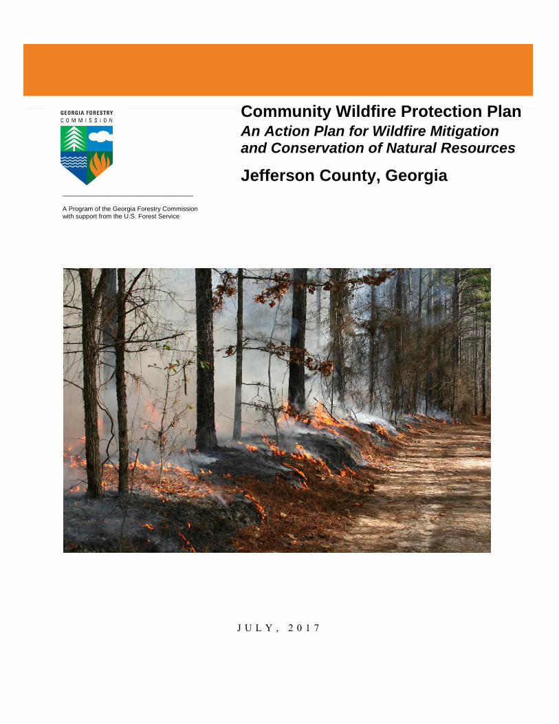
Community Wildfire Protection Plan An Action Plan for Wildfire Mitigation and Conservation of Natural Resources
Jefferson County, Georgia
A Program of the Georgia Forestry Commission with support from the U.S. Forest Service
__________________________
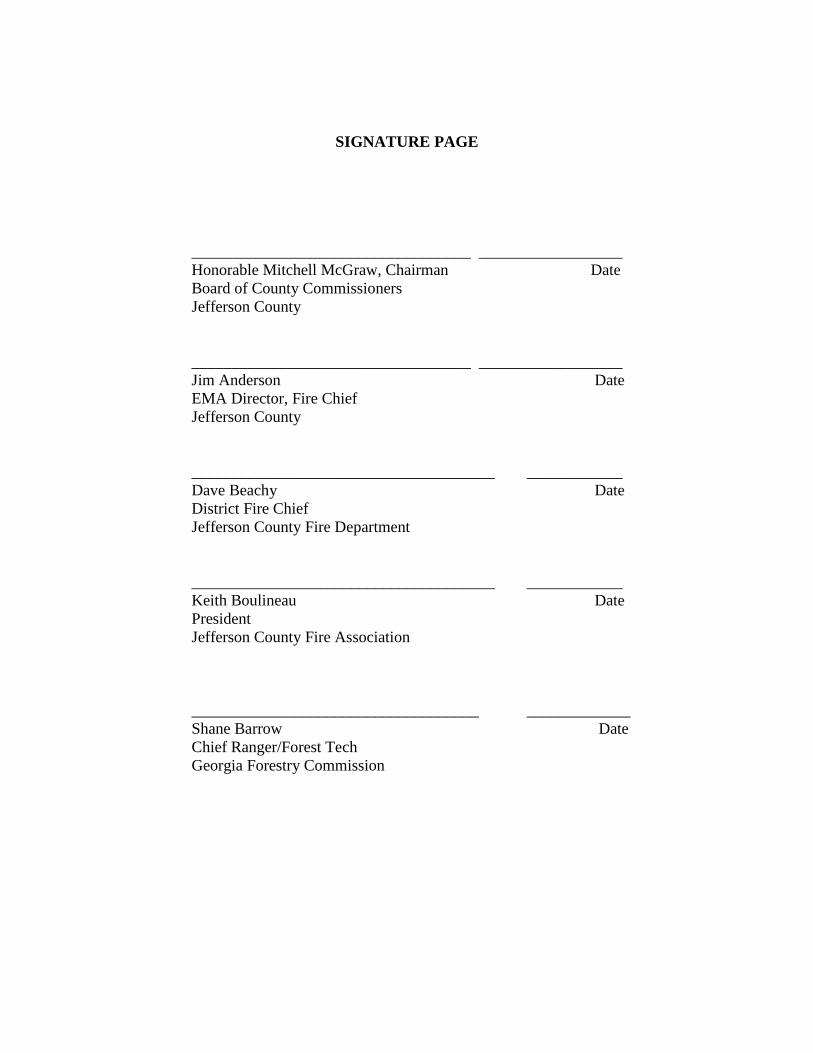
SIGNATURE PAGE
___________________________________ __________________
Honorable Mitchell McGraw, Chairman Date
Board of County Commissioners
Jefferson County
___________________________________ __________________
Jim Anderson Date
EMA Director, Fire Chief
Jefferson County
______________________________________ ____________
Dave Beachy Date
District Fire Chief
Jefferson County Fire Department
______________________________________ ____________
Keith Boulineau Date
President
Jefferson County Fire Association
____________________________________ _____________
Shane Barrow Date
Chief Ranger/Forest Tech
Georgia Forestry Commission
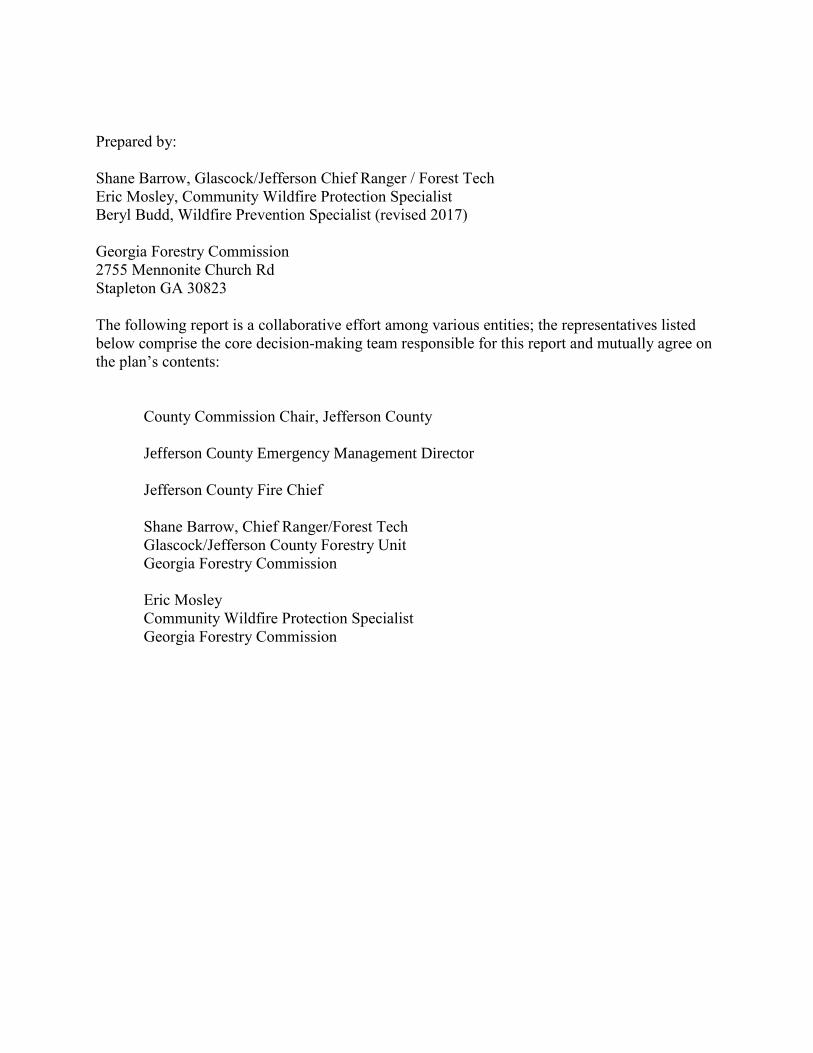
Prepared by:
Shane Barrow, Glascock/Jefferson Chief Ranger / Forest Tech
Eric Mosley, Community Wildfire Protection Specialist
Beryl Budd, Wildfire Prevention Specialist (revised 2017)
Georgia Forestry Commission
2755 Mennonite Church Rd
Stapleton GA 30823
The following report is a collaborative effort among various entities; the representatives listed
below comprise the core decision-making team responsible for this report and mutually agree on
the plan’s contents:
County Commission Chair, Jefferson County
Jefferson County Emergency Management Director
Jefferson County Fire Chief
Shane Barrow, Chief Ranger/Forest Tech
Glascock/Jefferson County Forestry Unit
Georgia Forestry Commission
Eric Mosley
Community Wildfire Protection Specialist
Georgia Forestry Commission
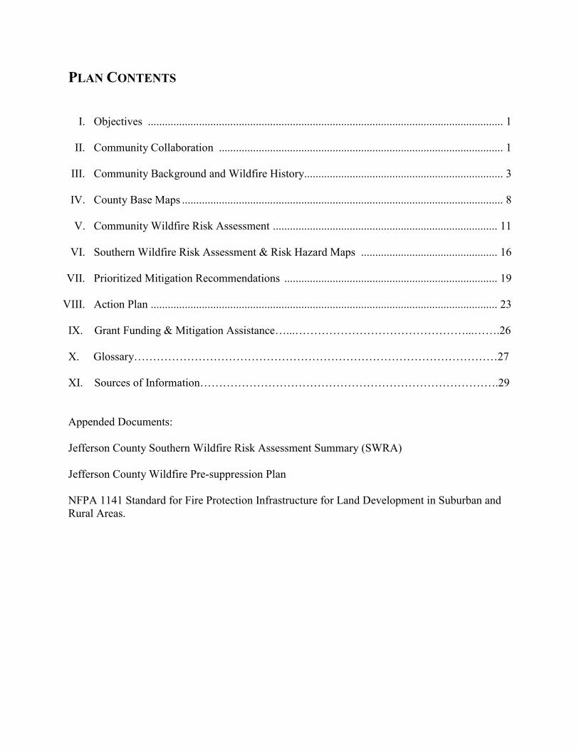
PLAN CONTENTS
I. Objectives ............................................................................................................................. 1
II. Community Collaboration .................................................................................................... 1
III. Community Background and Wildfire History...................................................................... 3
IV. County Base Maps ................................................................................................................. 8
V. Community Wildfire Risk Assessment ............................................................................... 11
VI. Southern Wildfire Risk Assessment & Risk Hazard Maps ................................................ 16
VII. Prioritized Mitigation Recommendations ........................................................................... 19
VIII. Action Plan .......................................................................................................................... 23
IX. Grant Funding & Mitigation Assistance…...………………………………………...…….26
X. Glossary……………………………………………………………………………………27
XI. Sources of Information…………………………………………………………………….29
Appended Documents:
Jefferson County Southern Wildfire Risk Assessment Summary (SWRA)
Jefferson County Wildfire Pre-suppression Plan
NFPA 1141 Standard for Fire Protection Infrastructure for Land Development in Suburban and
Rural Areas.
W I L D F I R E P R O T E C T I O N P L A N : A N A C T I O N P L A N F O R W I L D F I R E M I T I G A T I O N
P a g e 1
I. OBJECTIVES
A Community Wildfire Protection Plan (CWPP) provides a community with a road map to
reduce its risk from wildfire. A CWPP is designed through collaboration between state and local
fire agencies, homeowners and landowners, and other interested parties such as city councils,
utilities, homeowners associations, environmental organizations, and other local stakeholders.
The plan identifies strategic sites and methods for risk reduction and structural protection
projects across jurisdictional boundaries.
Comprehensive plans provide long-term guidance for growth, reflecting a community’s values
and future expectations. The plan implements the community’s values and serves to protect
natural and community resources and public safety. Planning also enables communities to
address their development patterns in the Wildland Urban Interface and determine how they can
reduce their risk through alternative development patterns. The formal legal standing of the plan
and its central role in local government decision making underscores the opportunity to use this
planning process as an effective means for reducing wildfire risk.
The mission of the following plan is to set clear priorities for the implementation of wildfire
mitigation in Jefferson County. The plan includes prioritized recommendations for the
appropriate types and methods of fuel reduction and structure ignitability reduction that will
protect this community and its essential infrastructure. It also includes a plan for wildfire
suppression. Specifically, the plan includes community-centered actions that will:
Educate citizens on wildfire, its risks, and ways to protect lives and properties,
Support fire rescue and suppression entities,
Focus on collaborative decision-making and citizen participation,
Develop and implement effective mitigation strategies, and
Develop and implement effective community ordinances and codes.
II. COMMUNITY COLLABORATION
Wildfire risk reduction strategies are most effective when approached collaboratively – involving
groups of residents, elected officials, community decision makers, emergency managers, and
natural resource managers –and when combined with effective outreach approaches.
Collaborative approaches make sense as the initial focus of any community attempting to work
toward wildfire risk reduction. In all Community Wildfire Protection Plan collaborations, the
goal is to cooperatively identify problems and reach a consensus for mutual action. In the case
of wildfire mitigation, a reduction in the wildfire risk to the community’s lives, houses, and
property is the desired outcome.
The collaborative core team convened in early February 2011 to assess risks and develop the
Community Wildfire Protection Plan. The group is comprised of representatives from local
county government, local fire authorities, and the Georgia Forestry Commission.
Below are the groups included in the task force:
W I L D F I R E P R O T E C T I O N P L A N : A N A C T I O N P L A N F O R W I L D F I R E M I T I G A T I O N
P a g e 2
Jefferson County Government
County Fire Department
Emergency Management
Board of County Commissioners
Georgia Forestry Commission
It was decided to conduct community assessments on the basis of the high risk communities and
the individual fire districts in the county. The Chief of the Jefferson County Fire Department and
the representative of the local Georgia Forestry Commission office reconvened in late August
and again in late October for the purpose of completing the following:
Risk Assessment Assessed wildfire hazard risks and prioritized mitigation actions.
The wildfire risk assessment will help homeowners, builders,
developers, and emergency personnel whether the area needs
attention and will help direct wildfire risk reduction practices to the
areas at highest risk.
Fuels Reduction Identified strategies for coordinating fuels treatment projects.
Structure Ignitability Identified strategies for reducing the ignitability of structures
within the Wildland interface.
Emergency Management Forged relationships among local government and fire districts and
developed/refined a pre-suppression plan.
Education and Outreach Developed strategies for increasing citizen awareness and action
and to conduct homeowner and community leader workshops.
Outreach and education programs are designed to raise awareness
and improve audience knowledge of wildfire risk reduction needs
and practices. In the best cases, education and outreach programs
will influence attitudes and opinions and result in effective action.
W I L D F I R E P R O T E C T I O N P L A N : A N A C T I O N P L A N F O R W I L D F I R E M I T I G A T I O N
P a g e 3
III. COUNTY BACKGROUND AND WILDFIRE HISTORY
County Background
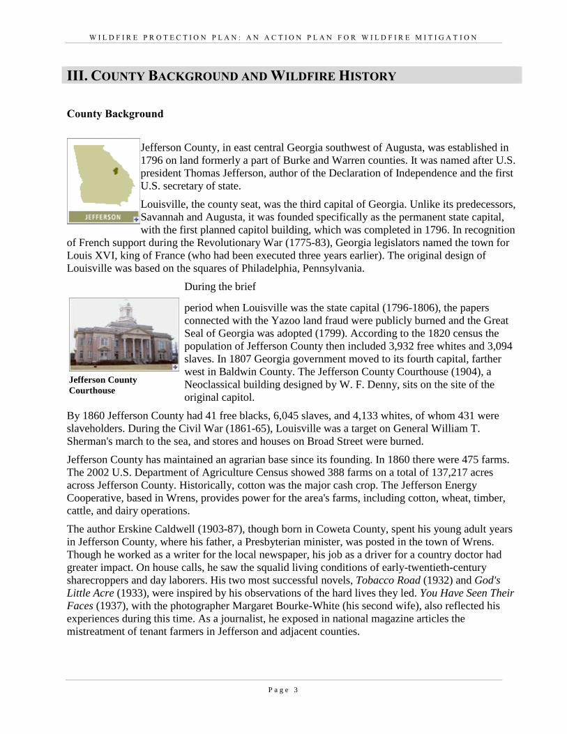
Jefferson County, in east central Georgia southwest of Augusta, was established in
1796 on land formerly a part of Burke and Warren counties. It was named after U.S.
president Thomas Jefferson, author of the Declaration of Independence and the first
U.S. secretary of state.
Louisville, the county seat, was the third capital of Georgia. Unlike its predecessors,
Savannah and Augusta, it was founded specifically as the permanent state capital,
with the first planned capitol building, which was completed in 1796. In recognition
of French support during the Revolutionary War (1775-83), Georgia legislators named the town for
Louis XVI, king of France (who had been executed three years earlier). The original design of
Louisville was based on the squares of Philadelphia, Pennsylvania.
During the brief
period when Louisville was the state capital (1796-1806), the papers
connected with the Yazoo land fraud were publicly burned and the Great
Seal of Georgia was adopted (1799). According to the 1820 census the
population of Jefferson County then included 3,932 free whites and 3,094
slaves. In 1807 Georgia government moved to its fourth capital, farther
west in Baldwin County. The Jefferson County Courthouse (1904), a
Neoclassical building designed by W. F. Denny, sits on the site of the
original capitol.
By 1860 Jefferson County had 41 free blacks, 6,045 slaves, and 4,133 whites, of whom 431 were
slaveholders. During the Civil War (1861-65), Louisville was a target on General William T.
Sherman's march to the sea, and stores and houses on Broad Street were burned.
Jefferson County has maintained an agrarian base since its founding. In 1860 there were 475 farms.
The 2002 U.S. Department of Agriculture Census showed 388 farms on a total of 137,217 acres
across Jefferson County. Historically, cotton was the major cash crop. The Jefferson Energy
Cooperative, based in Wrens, provides power for the area's farms, including cotton, wheat, timber,
cattle, and dairy operations.
The author Erskine Caldwell (1903-87), though born in Coweta County, spent his young adult years
in Jefferson County, where his father, a Presbyterian minister, was posted in the town of Wrens.
Though he worked as a writer for the local newspaper, his job as a driver for a country doctor had
greater impact. On house calls, he saw the squalid living conditions of early-twentieth-century
sharecroppers and day laborers. His two most successful novels, Tobacco Road (1932) and God's
Little Acre (1933), were inspired by his observations of the hard lives they led. You Have Seen Their
Faces (1937), with the photographer Margaret Bourke-White (his second wife), also reflected his
experiences during this time. As a journalist, he exposed in national magazine articles the
mistreatment of tenant farmers in Jefferson and adjacent counties.
Jefferson County
Courthouse
W I L D F I R E P R O T E C T I O N P L A N : A N A C T I O N P L A N F O R W I L D F I R E M I T I G A T I O N
P a g e 4
Other well-known residents of Jefferson County include two Georgia governors, William Schley and
Howell Cobb, as well as Cobb's brother, jurist Thomas R. R. Cobb, who served as a general during
the Civil War. Another Confederate general, Ambrose Wright, was born in Louisville and later
became owner and editor of the Augusta Chronicle. Prominent twentieth-century state legislator Roy
V. Harris also grew up in the county.
Wildfire History
Recent data show that a majority of the fastest growing areas in the U.S. are in wildfire-prone
environments. It is not a surprise that some of these fastest growing areas are in Georgia. In the last
decade of the 20th
Century, Georgia’s population increased substantially. Homeowners in Georgia
must contend with natural hazards including wildfire, tornados, and flooding. This combination of
factors – burgeoning population, abundant natural areas, development pressures, and lack of public
awareness makes Georgia a perfect state for creating solutions to various hazards. Georgia is looked
to throughout the southern region as a leader in comprehensive and hazard mitigation planning.
Many of Georgia’s existing and new residents living in the urban interface are unaware of the vital
role fire plays in our landscape and that their homes are extremely vulnerable to wildfire damage.
Balancing development pressures with wildfire risk reduction and education creates a unique
challenge for local governments, emergency managers, and wildfire management agencies such as
the Georgia Forestry Commission.
Over the past ten years, Jefferson County has averaged 63 reported wildfires per year. The
occurrence of these fires is fairly uniform throughout the year with a slight peak in the months of
February and March and a slight decrease during the fall months. These fires have burned an
average of 171 acres annually. While the numbers of fires remain fairly similar every month, there is
a marked difference in the monthly acreage lost. The monthly acres lost during the late winter
through summer period show a tenfold increase over the acres lost during the fall and early winter.
Additionally while the annual numbers of fires have not increased noticeably during the 10 year
period that records are available, the annual acreage lost appears to have decreased in later years.
This perhaps a result of the increase in the practice of prescribed burning. The local Georgia
Forestry Commission office needs to be commended for their valiant work increasing their very
impressive prescribed burning regiment. The Glascock / Jefferson Unit lead their district in Central
Georgia for burning. Despite their work, more homes are being built outside of traditional
communities into the wildland urban interface. With this migration of people to the wildland urban
interface the potential for a wildfire disaster continues to increase for Jefferson County.
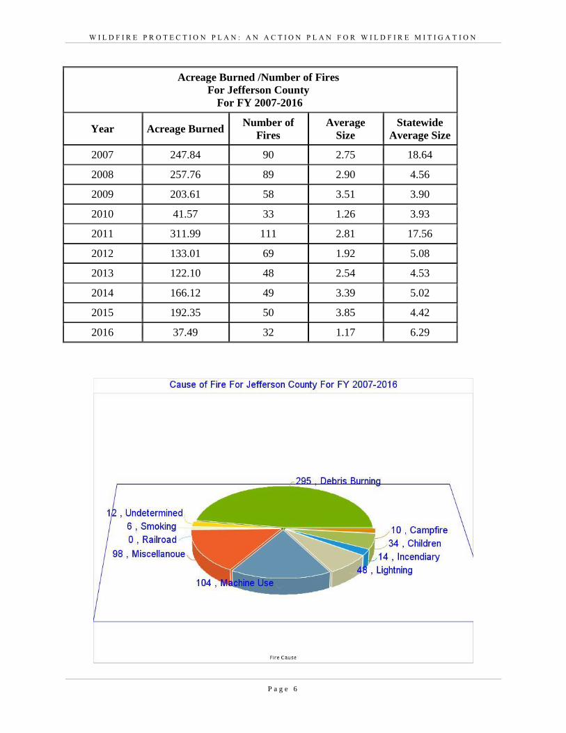
The leading cause of these fires in Jefferson County was careless Debris Burning, which accounted
for 48% of the total. The second leading cause was Machine Use (17%) followed by a variety of
miscellaneous causes (16%). Lightning started 8% of the wildfires during the 10 year period.
W I L D F I R E P R O T E C T I O N P L A N : A N A C T I O N P L A N F O R W I L D F I R E M I T I G A T I O N
P a g e 5
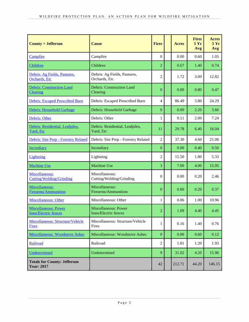
County = Jefferson Cause Fires Acres
Fires
5 Yr
Avg
Acres
5 Yr
Avg
Campfire Campfire 0 0.00 0.60 1.05
Children Children 2 0.67 1.40 0.74
Debris: Ag Fields, Pastures,
Orchards, Etc
Debris: Ag Fields, Pastures,
Orchards, Etc 2 1.72 3.00 12.82
Debris: Construction Land
Clearing
Debris: Construction Land
Clearing 0 0.00 0.80 0.47
Debris: Escaped Prescribed Burn Debris: Escaped Prescribed Burn 4 86.49 3.80 24.29
Debris: Household Garbage Debris: Household Garbage 0 0.00 2.20 3.66
Debris: Other Debris: Other 1 0.11 2.00 7.24
Debris: Residential, Leafpiles,
Yard, Etc
Debris: Residential, Leafpiles,
Yard, Etc 11 29.78 6.40 16.04
Debris: Site Prep - Forestry Related Debris: Site Prep - Forestry Related 2 37.30 4.60 21.06
Incendiary Incendiary 0 0.00 0.40 0.50
Lightning Lightning 2 15.50 1.80 5.33
Machine Use Machine Use 3 7.00 4.00 15.95
Miscellaneous:
Cutting/Welding/Grinding
Miscellaneous:
Cutting/Welding/Grinding 0 0.00 0.20 2.46
Miscellaneous:
Firearms/Ammunition
Miscellaneous:
Firearms/Ammunition 0 0.00 0.20 0.37
Miscellaneous: Other Miscellaneous: Other 1 0.06 1.00 10.96
Miscellaneous: Power
lines/Electric fences
Miscellaneous: Power
lines/Electric fences 2 1.09 4.40 4.45
Miscellaneous: Structure/Vehicle
Fires
Miscellaneous: Structure/Vehicle
Fires 1 0.16 1.40 0.76
Miscellaneous: Woodstove Ashes Miscellaneous: Woodstove Ashes 0 0.00 0.60 0.12
Railroad Railroad 2 1.81 1.20 1.93
Undetermined Undetermined 9 31.02 4.20 15.96
Totals for County: Jefferson
Year: 2017 42 212.71 44.20 146.15
W I L D F I R E P R O T E C T I O N P L A N : A N A C T I O N P L A N F O R W I L D F I R E M I T I G A T I O N
P a g e 6
Acreage Burned /Number of Fires
For Jefferson County
For FY 2007-2016
Year Acreage Burned Number of
Fires
Average
Size
Statewide
Average Size
2007 247.84 90 2.75 18.64
2008 257.76 89 2.90 4.56
2009 203.61 58 3.51 3.90
2010 41.57 33 1.26 3.93
2011 311.99 111 2.81 17.56
2012 133.01 69 1.92 5.08
2013 122.10 48 2.54 4.53
2014 166.12 49 3.39 5.02
2015 192.35 50 3.85 4.42
2016 37.49 32 1.17 6.29
W I L D F I R E P R O T E C T I O N P L A N : A N A C T I O N P L A N F O R W I L D F I R E M I T I G A T I O N
P a g e 7
W I L D F I R E P R O T E C T I O N P L A N : A N A C T I O N P L A N F O R W I L D F I R E M I T I G A T I O N
P a g e 8
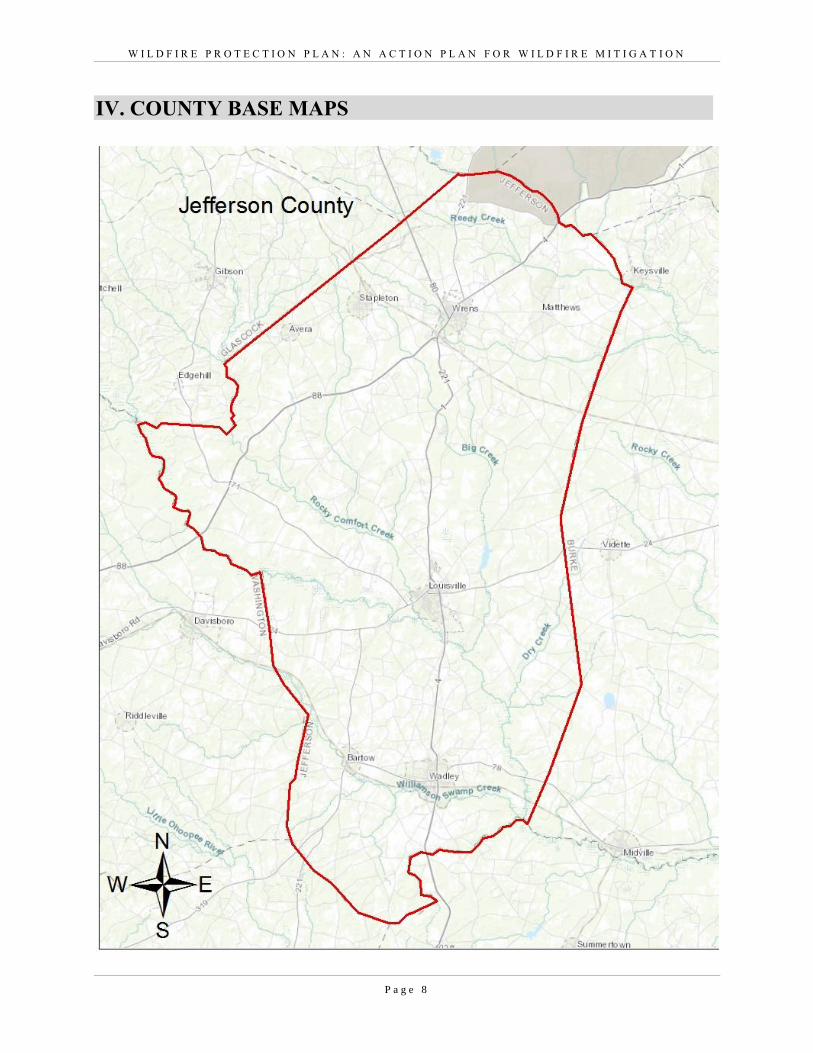
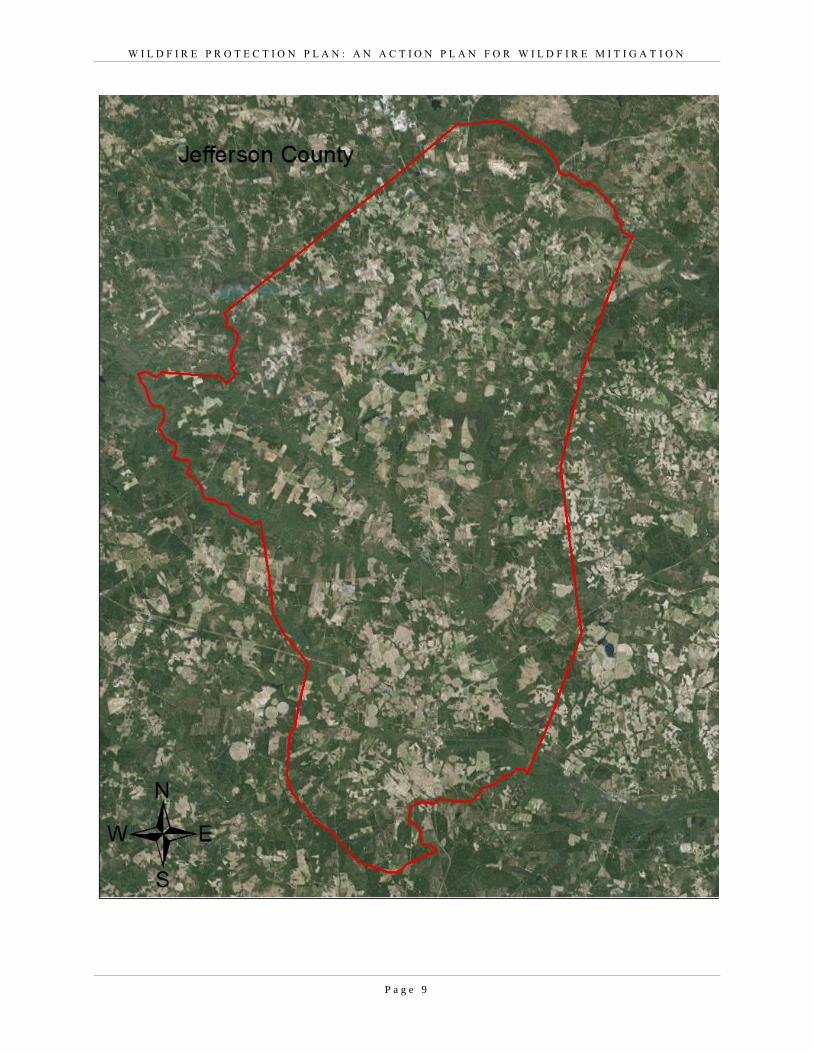
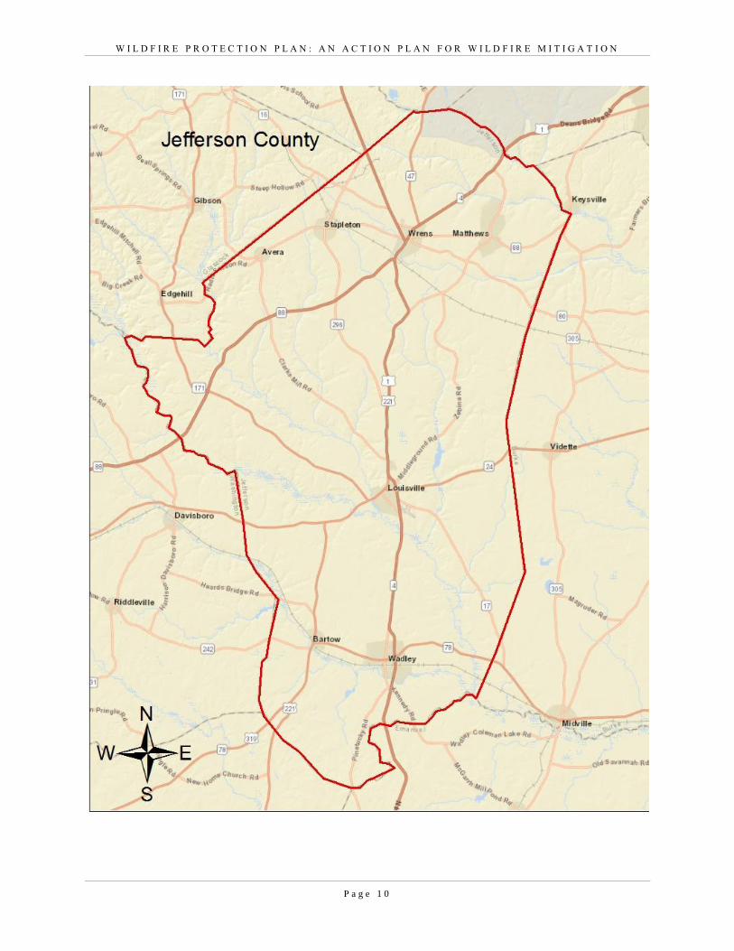
IV. COUNTY BASE MAPS
W I L D F I R E P R O T E C T I O N P L A N : A N A C T I O N P L A N F O R W I L D F I R E M I T I G A T I O N
P a g e 9
W I L D F I R E P R O T E C T I O N P L A N : A N A C T I O N P L A N F O R W I L D F I R E M I T I G A T I O N
P a g e 1 0
W I L D F I R E P R O T E C T I O N P L A N : A N A C T I O N P L A N F O R W I L D F I R E M I T I G A T I O N
P a g e 1 1
V. COMMUNITY WILDFIRE RISK ASSESSMENT
The Wildland Urban Interface
There are many definitions of the Wildland-Urban Interface (WUI), however from a fire
management perspective it is commonly defined as an area where structures and other human
development meet or intermingles with undeveloped wildland or vegetative fuels. As fire is
dependent on a certain set of conditions, the National Wildfire Coordinating Group has defined
the wildland-urban interface as a set of conditions that exists in or near areas of wildland fuels,
regardless of ownership. This set of conditions includes type of vegetation, building
construction, accessibility, lot size, topography and other factors such as weather and humidity.
When these conditions are present in certain combinations, they make some communities more
vulnerable to wildfire damage than others. This “set of conditions” method is perhaps the best
way to define wildland-urban interface areas when planning for wildfire prevention, mitigation,
and protection activities.
There are three major categories of wildland-urban interface. Depending on the set of
conditions present, any of these areas may be at risk from wildfire. A wildfire risk assessment
can determine the level of risk.
1. “Boundary” wildland-urban interface is characterized by areas of development where
homes, especially new subdivisions, press against public and private wildlands, such as private
or commercial forest land or public forests or parks. This is the classic type of wildland-urban
interface, with a clearly defined boundary between the suburban fringe and the rural
countryside.
2. “Intermix” wildland-urban interface areas are places where improved property and/or
structures are scattered and interspersed in wildland areas. These may be isolated rural homes or
an area that is just beginning to go through the transition from rural to urban land use.
3. “Island” wildland-urban interface, also called occluded interface, are areas of wildland
within predominately urban or suburban areas. As cities or subdivisions grow, islands of
undeveloped land may remain, creating remnant forests. Sometimes these remnants exist as
parks, or as land that cannot be developed due to site limitations, such as wetlands.
(courtesy Fire Ecology and Wildfire Mitigation in Florida 2004)
W I L D F I R E P R O T E C T I O N P L A N : A N A C T I O N P L A N F O R W I L D F I R E M I T I G A T I O N
P a g e 1 2
Wildland Urban Interface Hazards
Firefighters in the wildland urban interface may encounter hazards other than the fire itself, such as
hazardous materials, utility lines and poor access.
Hazardous Materials
Common chemicals used around the home may be a direct hazard to firefighters from
flammability, explosion potential and/or vapors or off-gassing. Such chemicals include
paint, varnish and other flammable liquids; fertilizer; pesticides; cleansers; aerosol cans,
fireworks, batteries and ammunition. In addition, some common household products such
as plastics may give off very toxic fumes when they burn. Stay OUT of the smoke from
burning structures and any unknown sources such as trash piles.
Illicit Activities
Marijuana plantations or drug production labs may be found in wildland urban interface
areas. Extremely hazardous materials such as propane tanks and flammable/toxic chemicals may be encountered, as well as booby traps.
Propane tanks
Both large (household size) and small (gas grill size) liquefied propane gas (LPG) tanks
can present hazards to firefighters, including explosion. See the "LPG Tank Hazards"
discussion for details.
W I L D F I R E P R O T E C T I O N P L A N : A N A C T I O N P L A N F O R W I L D F I R E M I T I G A T I O N
P a g e 1 3
Utility lines
Utility lines may be located above and below ground and may be cut or damaged by tools
or equipment. Don't spray water on utility lines or boxes.
Septic tanks and fields
Below-ground structures may not be readily apparent and may not support the weight of
engines or other apparatus.
New construction materials
Many new construction materials have comparatively low melting points and may "off-
gas" extremely hazardous vapors. Plastic decking materials that resemble wood are
becoming more common and may begin softening and losing structural strength at 180° F,
though they normally do not sustain combustion once direct flame is removed. However, if they continue to burn they exhibit the characteristics of flammable liquids.
Pets and livestock
Pets and livestock may be left when residents evacuate and will likely be highly stressed,
making them more inclined to bite and kick. Firefighters should not put themselves at risk to rescue pets or livestock.
Evacuation occurring
Firefighters may be taking structural protection actions while evacuations of residents are
occurring. Be very cautious of people driving erratically. Distraught residents may refuse
to leave their property, and firefighters may need to disengage from fighting fire to contact
law enforcement officers for assistance. In most jurisdictions firefighters do not have the
authority to force evacuations. Firefighters should not put themselves at risk trying to
protect someone who will not evacuate!
Limited access
Narrow one-lane roads with no turn-around room, inadequate or poorly maintained bridges
and culverts are frequently found in wildland urban interface areas. Access should be sized-up and an evacuation plan for all emergency personnel should be developed.
W I L D F I R E P R O T E C T I O N P L A N : A N A C T I O N P L A N F O R W I L D F I R E M I T I G A T I O N
P a g e 1 4
The wildland fire risk assessments conducted in 2011 by the Jefferson County Fire Department
and the Georgia Forestry Commission returned an average score of 112, placing Jefferson
County in the “very high risk” hazard range. The risk assessment instrument used to evaluate
wildfire hazards to Jefferson County’s WUI was the Hazard and Wildfire Risk Assessment
Checklist. The instrument takes into consideration accessibility, vegetation (based on fuel
models), roofing assembly, building construction, and availability of fire protection resources,
placement of gas and electric utilities, and additional rating factors. The following factors
contributed to the wildfire hazard score for Jefferson County:
Dead end roads with inadequate turn arounds
Narrow roads without drivable shoulders
Long, narrow, and poorly labeled driveways
Limited street signs and homes not clearly addressed
Thick, highly flammable vegetation surrounding many homes
Minimal defensible space around structures
Homes with wooden siding and roofs with heavy accumulations of vegetative debris
No pressurized or non-pressurized water systems available
Above ground utilities
Large, adjacent areas of forest or wildlands
Heavy fuel buildups in adjacent wildlands
Undeveloped lots comprising half the total lots in many rural communities
High occurrence of wildfires in the several locations
Distance from fire stations
Lack of homeowner or community organizations
W I L D F I R E P R O T E C T I O N P L A N : A N A C T I O N P L A N F O R W I L D F I R E M I T I G A T I O N
P a g e 1 5
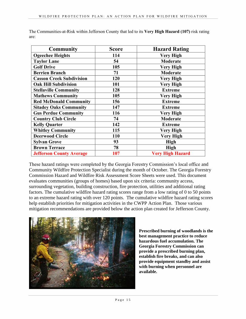
The Communities-at-Risk within Jefferson County that led to its Very High Hazard (107) risk rating
are:
Community Score Hazard Rating Ogeechee Heights 114 Very High
Taylor Lane 54 Moderate
Golf Drive 105 Very High
Berrien Branch 71 Moderate
Casson Creek Subdivision 120 Very High
Oak Hill Subdivision 101 Very High
Stellaville Community 128 Extreme
Mathews Community 105 Very High
Red McDonald Community 156 Extreme
Sitadey Oaks Community 147 Extreme
Gus Perdue Community 116 Very High
Country Club Circle 74 Moderate
Kelly Quarter 142 Extreme
Whitley Community 115 Very High
Deerwood Circle 110 Very High
Sylvan Grove 93 High
Brown Terrace 78 High
Jefferson County Average 107 Very High Hazard
These hazard ratings were completed by the Georgia Forestry Commission’s local office and
Community Wildfire Protection Specialist during the month of October. The Georgia Forestry
Commission Hazard and Wildfire Risk Assessment Score Sheets were used. This document
evaluates communities (groups of homes) based upon six criteria: community access,
surrounding vegetation, building construction, fire protection, utilities and additional rating
factors. The cumulative wildfire hazard rating scores range from a low rating of 0 to 50 points
to an extreme hazard rating with over 120 points. The cumulative wildfire hazard rating scores
help establish priorities for mitigation activities in the CWPP Action Plan. Those various
mitigation recommendations are provided below the action plan created for Jefferson County.
Prescribed burning of woodlands is the
best management practice to reduce
hazardous fuel accumulation. The
Georgia Forestry Commission can
provide a prescribed burning plan,
establish fire breaks, and can also
provide equipment standby and assist
with burning when personnel are
available.
W I L D F I R E P R O T E C T I O N P L A N : A N A C T I O N P L A N F O R W I L D F I R E M I T I G A T I O N
P a g e 1 6
Vl. SOUTHERN WILDFIRE RISK ASSESSMENT & HAZARD MAPS
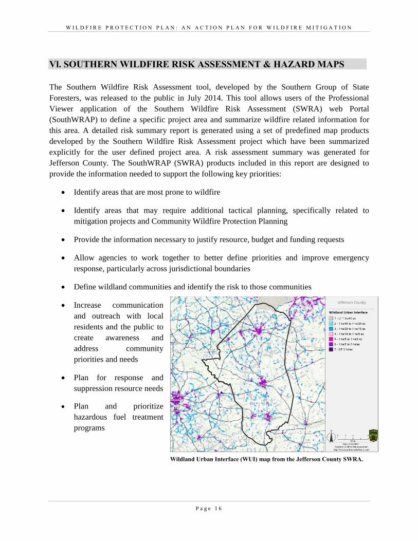
The Southern Wildfire Risk Assessment tool, developed by the Southern Group of State
Foresters, was released to the public in July 2014. This tool allows users of the Professional
Viewer application of the Southern Wildfire Risk Assessment (SWRA) web Portal
(SouthWRAP) to define a specific project area and summarize wildfire related information for
this area. A detailed risk summary report is generated using a set of predefined map products
developed by the Southern Wildfire Risk Assessment project which have been summarized
explicitly for the user defined project area. A risk assessment summary was generated for
Jefferson County. The SouthWRAP (SWRA) products included in this report are designed to
provide the information needed to support the following key priorities:
Identify areas that are most prone to wildfire
Identify areas that may require additional tactical planning, specifically related to
mitigation projects and Community Wildfire Protection Planning
Provide the information necessary to justify resource, budget and funding requests
Allow agencies to work together to better define priorities and improve emergency
response, particularly across jurisdictional boundaries
Define wildland communities and identify the risk to those communities
Increase communication
and outreach with local
residents and the public to
create awareness and
address community
priorities and needs
Plan for response and
suppression resource needs
Plan and prioritize
hazardous fuel treatment
programs
Wildland Urban Interface (WUI) map from the Jefferson County SWRA.
W I L D F I R E P R O T E C T I O N P L A N : A N A C T I O N P L A N F O R W I L D F I R E M I T I G A T I O N
P a g e 1 7
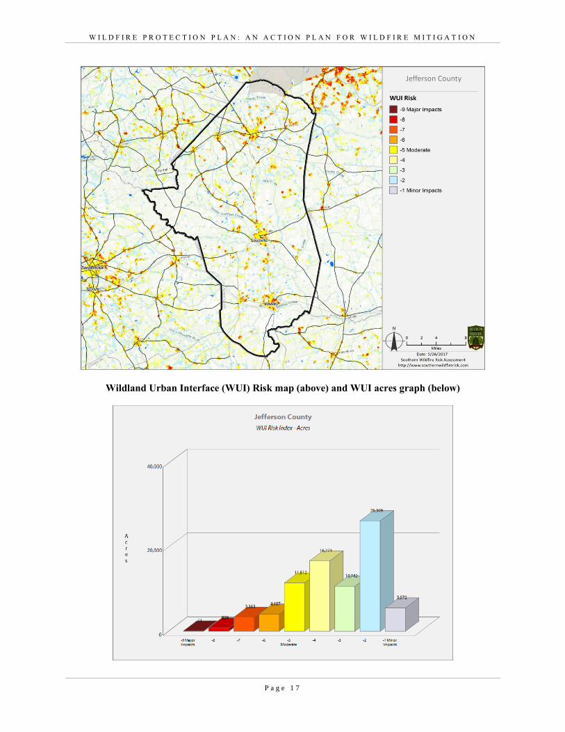
Wildland Urban Interface (WUI) Risk map (above) and WUI acres graph (below)
W I L D F I R E P R O T E C T I O N P L A N : A N A C T I O N P L A N F O R W I L D F I R E M I T I G A T I O N
P a g e 1 8
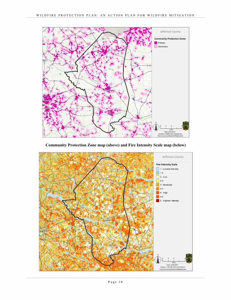
Community Protection Zone map (above) and Fire Intensity Scale map (below)
W I L D F I R E P R O T E C T I O N P L A N : A N A C T I O N P L A N F O R W I L D F I R E M I T I G A T I O N
P a g e 1 9
VII. PRIORITIZED MITIGATION RECOMMENDATIONS
Executive Summary
As Central Georgia continues to see increased growth from other areas seeking less crowded and
warmer climates, new development will occur more frequently on forest and wildland areas. The
County will have an opportunity to significantly influence the wildland fire safety of new
developments. It is important that new development be planned and constructed to provide for
public safety in the event of a wildland fire emergency.
Over the past 20 years, much has been learned about how and why homes burn during wildland
fire emergencies. Perhaps most importantly, case histories and research have shown that even in
the most severe circumstances, wildland fire disasters can be avoided. Homes can be designed,
built and maintained to withstand a wildfire even in the absence of fire services on the scene. The
national Firewise Communities program is a national awareness initiative to help people
understand that they don’t have to be victims in a wildfire emergency. The National Fire
Protection Association has produced two standards for reference: NFPA 1144 Standard for
Reducing Structure Ignition Hazards from Wildland Fire. 2008 Edition and NFPA 1141 Standard
for Fire Protection Infrastructure for Land Development in Suburban and Rural Areas.
When new developments are built in the Wildland/Urban Interface, a number of public safety
challenges may be created for the local fire services: (1) the water supply in the immediate areas
may be inadequate for fire suppression; (2) if the Development is in an outlying area, there may be
a longer response time for emergency services; (3) in a wildfire emergency, the access road(s) may
need to simultaneously support evacuation of residents and the arrival of emergency vehicles; and
(4) when wildland fire disasters strike, many structures may be involved simultaneously, quickly
exceeding the capability of even the best equipped fire departments.
The following recommendations were developed by the Jefferson County CWPP Core team as a
result of surveying and assessing fuels and structures and by conducting meetings and interviews
with county and city officials. A priority order was determined based on which mitigation projects
would best reduce the hazard of wildfire in the assessment area.
Proposed Community Hazard and Structural Ignitability Reduction Priorities
Primary Protection for Community and Its Essential Infrastructure
Treatment Area Treatment Types Treatment Method(s)
1. All Structures Create minimum of 30-
feet of defensible
space**
Trim shrubs and vines to 30 feet from
structures, trim overhanging limbs,
replace flammable plants near homes
with less flammable varieties, remove
vegetation around chimneys.
W I L D F I R E P R O T E C T I O N P L A N : A N A C T I O N P L A N F O R W I L D F I R E M I T I G A T I O N
P a g e 2 0
2. Applicable Structures Reduce structural
ignitability**
Clean flammable vegetative material
from roofs and gutters, store firewood
appropriately, install skirting around
raised structures, store water hoses for
ready access, and replace pine straw and
mulch around plantings with less
flammable landscaping materials.
3. Community Clean-up Day Cutting, mowing,
pruning**
Cut, prune, and mow vegetation in
shared community spaces.
4. Driveway Access Culvert installation See that adequate lengths of culverts are
installed to allow emergency vehicle
access.
5. Road Access Identify needed road
improvements
As roads are upgraded, widen to
minimum standards with at least 50 foot
diameter cul de sacs or turn arounds.
Proposed Community Wildland Fuel Reduction Priorities
Treatment Area Treatment Types Treatment Method(s)
1. Adjacent WUI Lands Reduce hazardous fuels
Encourage prescribed burning for
private landowners and industrial
timberlands particularly adjacent to
residential areas.
County resolution to state
recommending that the Ga Forestry
Commission not charge for prescribed
burning in WUI areas.
Seek grant for WUI mitigation team.
2. Railroad Corridors Reduce hazardous fuels
Encourage railroads to better maintain
their ROW eliminating brush and grass
through herbicide and mowing.
Maintain firebreaks along ROW
adjacent to residential areas.
3. Existing Fire Lines Reduce hazardous fuels Clean and re-harrow existing lines.
W I L D F I R E P R O T E C T I O N P L A N : A N A C T I O N P L A N F O R W I L D F I R E M I T I G A T I O N
P a g e 2 1
Proposed Improved Community Wildland Fire Response Priorities
1. Water Sources Dry Hydrants Inspect, maintain and improve access to
existing dry hydrants. Add signage
along road to mark the hydrants.
Locate additional dry hydrants as
needed.
2. Fire Stations Equipment Wildland hand tools. Lightweight
Wildland PPE Gear. Investigate need
for “brush” trucks near communities at
risk.
3. Water Sources Drafting equipment Investigate need for additional drafting
pumps.
4. Personnel Training Obtain Wildland Fire Suppression
training for fire personnel to include
S130, S190, and S215.
**Actions to be taken by homeowners and community stakeholders
Proposed Education and Outreach Priorities
1. Conduct “How to Have a Firewise Home” Workshop for County Residents
Set up and conduct a workshop for homeowners that teach the principles of making homes and
properties safe from wildfire. Topics for discussion include defensible space, landscaping, building
construction, etc. Workshop will be scheduled for evenings or weekends when most homeowners are
available and advertised through local media outlets.
Distribute materials promoting Firewise practices and planning through local community and
governmental meetings.
2. Conduct “Firewise” Workshop for Community Leaders
Arrange for GFC Firewise Coordinator to work with local community leaders and governmental
officials on the importance of “Firewise Planning” in developing ordinances and codes as the county
as the need arises. Identified “communities-at-risk” including: Kelly Quarter, Mathews Community
Stellaville, and Ogeechee Heights should be sought after for inclusion in the National Firewise
Communities Program.
W I L D F I R E P R O T E C T I O N P L A N : A N A C T I O N P L A N F O R W I L D F I R E M I T I G A T I O N
P a g e 2 2
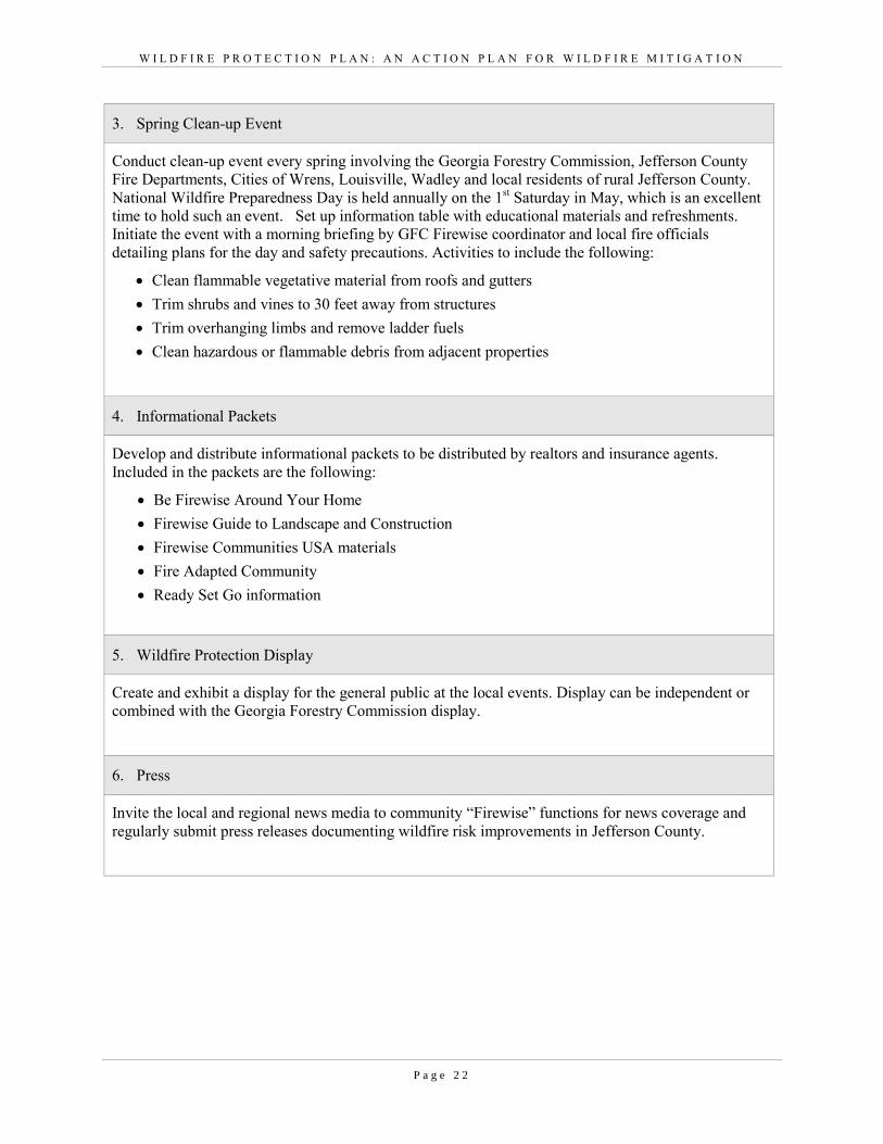
3. Spring Clean-up Event
Conduct clean-up event every spring involving the Georgia Forestry Commission, Jefferson County
Fire Departments, Cities of Wrens, Louisville, Wadley and local residents of rural Jefferson County.
National Wildfire Preparedness Day is held annually on the 1st Saturday in May, which is an excellent
time to hold such an event. Set up information table with educational materials and refreshments.
Initiate the event with a morning briefing by GFC Firewise coordinator and local fire officials
detailing plans for the day and safety precautions. Activities to include the following:
Clean flammable vegetative material from roofs and gutters
Trim shrubs and vines to 30 feet away from structures
Trim overhanging limbs and remove ladder fuels
Clean hazardous or flammable debris from adjacent properties
4. Informational Packets
Develop and distribute informational packets to be distributed by realtors and insurance agents.
Included in the packets are the following:
Be Firewise Around Your Home
Firewise Guide to Landscape and Construction
Firewise Communities USA materials
Fire Adapted Community
Ready Set Go information
5. Wildfire Protection Display
Create and exhibit a display for the general public at the local events. Display can be independent or
combined with the Georgia Forestry Commission display.
6. Press
Invite the local and regional news media to community “Firewise” functions for news coverage and
regularly submit press releases documenting wildfire risk improvements in Jefferson County.
W I L D F I R E P R O T E C T I O N P L A N : A N A C T I O N P L A N F O R W I L D F I R E M I T I G A T I O N
P a g e 2 3
VIII. ACTION PLAN
Roles and Responsibilities
The following roles and responsibilities have been developed to implement the action plan:
Role Responsibility
Hazardous Fuels and Structural Ignitability Reduction
Jefferson County WUI Fire
Council
Create this informal team or council comprised of residents, GFC
officials, County Fire department officials, a representative from
the city and county government and the EMA Director for Jefferson
County. Meet periodically to review progress towards mitigation
goals, appoint and delegate special activities, work with federal,
state, and local officials to assess progress and develop future goals
and action plans. Work with residents to implement projects and
Firewise activities.
Key Messages to focus on 1 Defensible Space and Firewise Landscaping
2 Debris Burning Safety
3 Firewise information for homeowners
4 Prescribed burning benefits
Communications objectives 1 Create public awareness for fire danger and defensible space
issues
2 Identify most significant human cause fire issues
3 Enlist public support to help prevent these causes
4 Encourage citizens to employ fire prevention and defensible
spaces in their communities.
Target Audiences 1 Homeowners
2 Forest Landowners and users
3 Civic Groups
4 School Groups
Methods 1 News Releases
2 Personal Contacts
3 Key messages and prevention tips
4 Visuals such as signs, brochures and posters
5 Social media
W I L D F I R E P R O T E C T I O N P L A N : A N A C T I O N P L A N F O R W I L D F I R E M I T I G A T I O N
P a g e 2 4
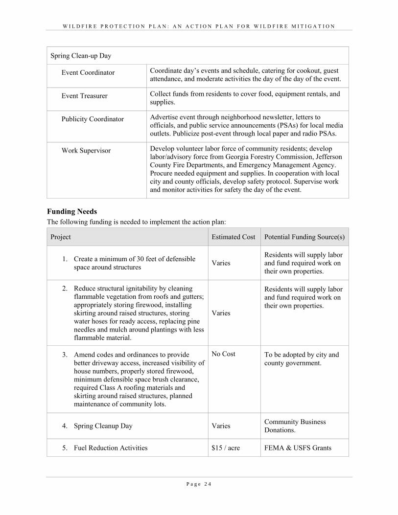
Spring Clean-up Day
Event Coordinator Coordinate day’s events and schedule, catering for cookout, guest
attendance, and moderate activities the day of the day of the event.
Event Treasurer Collect funds from residents to cover food, equipment rentals, and
supplies.
Publicity Coordinator Advertise event through neighborhood newsletter, letters to
officials, and public service announcements (PSAs) for local media
outlets. Publicize post-event through local paper and radio PSAs.
Work Supervisor Develop volunteer labor force of community residents; develop
labor/advisory force from Georgia Forestry Commission, Jefferson
County Fire Departments, and Emergency Management Agency.
Procure needed equipment and supplies. In cooperation with local
city and county officials, develop safety protocol. Supervise work
and monitor activities for safety the day of the event.
Funding Needs
The following funding is needed to implement the action plan:
Project Estimated Cost Potential Funding Source(s)
1. Create a minimum of 30 feet of defensible
space around structures Varies
Residents will supply labor
and fund required work on
their own properties.
2. Reduce structural ignitability by cleaning
flammable vegetation from roofs and gutters;
appropriately storing firewood, installing
skirting around raised structures, storing
water hoses for ready access, replacing pine
needles and mulch around plantings with less
flammable material.
Varies
Residents will supply labor
and fund required work on
their own properties.
3. Amend codes and ordinances to provide
better driveway access, increased visibility of
house numbers, properly stored firewood,
minimum defensible space brush clearance,
required Class A roofing materials and
skirting around raised structures, planned
maintenance of community lots.
No Cost To be adopted by city and
county government.
4. Spring Cleanup Day Varies Community Business
Donations.
5. Fuel Reduction Activities $15 / acre FEMA & USFS Grants
W I L D F I R E P R O T E C T I O N P L A N : A N A C T I O N P L A N F O R W I L D F I R E M I T I G A T I O N
P a g e 2 5
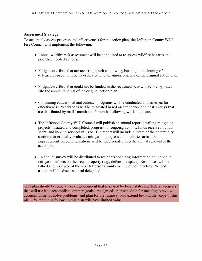
Assessment Strategy
To accurately assess progress and effectiveness for the action plan, the Jefferson County WUI
Fire Council will implement the following:
Annual wildfire risk assessment will be conducted to re-assess wildfire hazards and
prioritize needed actions.
Mitigation efforts that are recurring (such as mowing, burning, and clearing of
defensible space) will be incorporated into an annual renewal of the original action plan.
Mitigation efforts that could not be funded in the requested year will be incorporated
into the annual renewal of the original action plan.
Continuing educational and outreach programs will be conducted and assessed for
effectiveness. Workshops will be evaluated based on attendance and post surveys that
are distributed by mail 1month and 6 months following workshop date.
The Jefferson County WUI Council will publish an annual report detailing mitigation
projects initiated and completed, progress for ongoing actions, funds received, funds
spent, and in-kind services utilized. The report will include a “state of the community”
section that critically evaluates mitigation progress and identifies areas for
improvement. Recommendations will be incorporated into the annual renewal of the
action plan.
An annual survey will be distributed to residents soliciting information on individual
mitigation efforts on their own property (e.g., defensible space). Responses will be
tallied and reviewed at the next Jefferson County WUI Council meeting. Needed
actions will be discussed and delegated.
This plan should become a working document that is shared by local, state, and federal agencies
that will use it to accomplish common goals. An agreed-upon schedule for meeting to review
accomplishments, solve problems, and plan for the future should extend beyond the scope of this
plan. Without this follow up this plan will have limited value
W I L D F I R E P R O T E C T I O N P L A N : A N A C T I O N P L A N F O R W I L D F I R E M I T I G A T I O N
P a g e 2 6
lX. GRANT FUNDING & MITIGATION ASSISTANCE
Community Protection Grant: US Forest Service sponsored prescribed fire program.
Communities with “at-risk” properties that lie within ten miles of a National Forest, National
Park Service or Bureau of Land Management tracts may apply with the Georgia Forestry
Commission to have their land prescribe burned free-of-charge. Forest mastication, where it is
practical with Georgia Forestry Commission equipment, is also available under this grant
program.
FEMA Mitigation Policy MRR-2-08-01: through GEMA – Hazard Mitigation Grant Program
(HMGP) and Pre-Disaster Mitigation Program (PDM).
1. To provide technical and financial assistance to local governments to assist in the
implementation of long term, cost effective hazard mitigation accomplishments.
2. This policy addresses wildfire mitigation for the purpose of reducing the threat to all-risk
structures through creating defensible space, structural protection through the
application of ignition resistant construction and limited hazardous fuel reduction to
protect life and property.
3. With a completed registered plan (addendum to the State Plan) counties can apply for
pre-mitigation funding. They will also be eligible for HMGP funding if the county is
declared under a wildfire disaster.
Georgia Forestry Commission: Plowing and prescribed burning assistance, as well as forest
mastication, can be obtained from the GFC as a low-cost option for mitigation efforts.
The Georgia Forestry Commission Firewise Community Mitigation Assistance Grants –
Nationally recognized Firewise Communities can receive up to $5000 grants to help address
potential wildfire risk reduction projects. Grant submission can be made through local Georgia
Forestry Commission offices or your Regional Wildfire Prevention Specialist.
The International Association of Fire Chiefs (IAFC) and American International Group,
Inc. (AIG) offer grants to assist local fire departments in establishing or enhancing their
community fuels mitigation programs while educating members of the community about
community wildfire readiness and encouraging personal action.

W I L D F I R E P R O T E C T I O N P L A N : A N A C T I O N P L A N F O R W I L D F I R E M I T I G A T I O N
P a g e 2 7
X. GLOSSARY
Community-At-Risk – A group of two or more structures whose proximity to forested or
wildland areas places homes and residents at some degree of risk.
Critical Facilities – Buildings, structures or other parts of the community infrastructure that
require special protection from an approaching wildfire.
CWPP – The Community Wildfire Protection Plan.
Defensible Space – The immediate landscaped area around a structure (usually a minimum of 30
ft.) kept “lean, clean and green” to prevent an approaching wildfire from igniting the structure.
Dry Hydrant - A non-pressurized pipe system permanently installed in existing lakes, ponds and
streams that provides a suction supply of water to a fire department tank truck.
FEMA – The Federal Emergency Management Agency whose mission is to support our citizens
and first responders to ensure that as a nation we work together to build, sustain, and improve
our capability to prepare for, protect against, respond to, recover from, and mitigate all hazards.
Fire Adapted Community – A community fully prepared for its wildfire risk by taking actions to
address safety, homes, neighborhoods, businesses and infrastructure, forest, parks, open spaces,
and other community assets.
Firewise Program – A national initiative with a purpose to reduce structural losses from
wildland fires.
Firewise Community/USA – A national recognition program for communities that take action to
protect themselves from wildland fire. To qualify a community must have a wildfire risk
assessment by the Georgia Forestry Commission, develop a mitigation action plan, have an
annual firewise mitigation/education event, have dedicated firewise leadership, and complete the
certification application.
Fuels – All combustible materials within the wildland/urban interface or intermix including, but
not limited to, vegetation and structures.
Fuel Modification – Any manipulation or removal of fuels to reduce the likelihood of ignition or
the resistance to fire control.
Hazard & Wildfire Risk Assessment – An evaluation to determine an area’s (community’s)
potential to be impacted by an approaching wildland fire.
Healthy Forests Initiative - Launched in August 2002 by President Bush (following passage of
the Healthy Forests Restoration Act by Congress) with the intent to reduce the risks severe
wildfires pose to people, communities, and the environment.

W I L D F I R E P R O T E C T I O N P L A N : A N A C T I O N P L A N F O R W I L D F I R E M I T I G A T I O N
P a g e 2 8
Home Ignition Zone (Structure Ignition Zone) - Treatment area for wildfire protection. The
“zone” includes the structure(s) and their immediate surroundings from 0-200 ft.
Mitigation – An action that moderates the severity of a fire hazard or risk.
National Fire Plan – National initiative, passed by Congress in the year 2000, following a
landmark wildland fire season, with the intent of actively responding to severe wildland fires and
their impacts to communities while ensuring sufficient firefighting capacity for the future.
National Fire Protection Association (NFPA) - An international nonprofit organization
established in 1896, whose mission is to reduce the worldwide burden of fire and other hazards
on the quality of life by providing and advocating consensus codes and standards, research,
training, and education.
National Wildfire Preparedness Day – Started in 2014 by the National Fire Protection
Association as a day for communities to work together to prepare for the fire season. It is held
annually on the first Saturday in May.
Prescribed Burning (prescribed fire) –The use of planned fire that is deliberately set under
specific fuel and weather condition to accomplish a variety of management objectives and is
under control until it burns out or is extinguished.
Ready, Set, Go - A program fire services use to help homeowners understand wildfire
preparedness, awareness, and planning procedures for evacuation.
Southern Group of State Foresters – Organization whose members are the agency heads of the
forestry agencies of the 13 southern states, Puerto Rico and the Virgin Islands.
Stakeholders– Individuals, groups, organizations, businesses or others who have an interest in
wildland fire protection and may wish to review and/or contribute to the CWPP content.
Wildfire or Wildland Fire – An unplanned and uncontrolled fire spreading through vegetative
fuels.
Wildland/Urban Interface - The presence of structures in locations in which the authority having
jurisdiction (AHJ) determines that topographical features, vegetation, fuel types, local weather
conditions and prevailing winds result in the potential for ignition of the structures within the
area from flames and firebrands from a wildland fire (NFPA 1144, 2008 edition.
W I L D F I R E P R O T E C T I O N P L A N : A N A C T I O N P L A N F O R W I L D F I R E M I T I G A T I O N
P a g e 2 9
XI. SOURCES OF INFORMATION
Publications/Brochures/Websites:
FIREWISE materials can be ordered at www.firewise.org
Georgia Forestry Commission www.georgiafirewise.org
Examples of successful wildfire mitigation programs can be viewed at the website for National
Database of State and Local wildfire Hazard Mitigation Programs sponsored by the U.S. Forest
Service and the Southern Group of State Foresters www.wildfireprograms.com
Information about a variety of interface issues (including wildfire) can be found at the USFS
website for Interface South: www.interfacesouth.org
Information on codes and standards for emergency services including wildfire can be found at
www.nfpa.org
Information on FEMA Assistance to Firefighters Grants (AFG) can be found at
www.firegrantsupport.com
Information on National Fire Plan grants can be found at
http://www.federalgrantswire.com/national-fire-plan--rural-fire-assistance.html
Southern Wildfire Risk Assessment website SouthWRAP www.SouthernWildfireRisk.com
Fire Adapted Communities www.fireadapted.org
Ready, Set, Go www.wildlandfirersg.org
National Wildfire Preparedness Day www.wildfireprepday.org
Appended Documents:
Jefferson County Southern Wildfire Risk Assessment Summary Report (SWRA)
All files that make up this plan are available in an electronic format from the Georgia Forestry
Commission.
W I L D F I R E P R O T E C T I O N P L A N : A N A C T I O N P L A N F O R W I L D F I R E M I T I G A T I O N
P a g e 3 0
Georgia Forestry Commission 5645 Riggins Mill Rd. Dry Branch, GA 31020 800-GA-TREES GaTrees.org The Georgia Forestry Commission provides leadership, service, and education in the protection and conservation of Georgia’s forest resources. An Equal Opportunity Employer and Service Provider