Embed Size (px)
Citation preview
COMPAGNIE MINIÈRE CONGOLAISE S.P.R.L. - CoMiCo assets in the Cuvette Centrale (Busira and Lokoro Sub-Basins) of the Democratic Republic of Congo
March 2008 Prepared by
HRT - HIGH RESOLUTION TECHNOLOGY & PETROLEUM LTDA
Executive Summary of the Petroleum potential of Cuvette Centrale - DRC
HRT Petroleum is carriying out, for COMPAGNIE MINIÈRE CONGOLAISE S.P.R.L. – CoMiCo, a petroleum system and hydrocarbon
evaluation of the CoMiCo’s exploratory blocks in the Cuvette Centrale (Busira and Lokoro Sub-Basins) of the Democratic Republic of Congo.
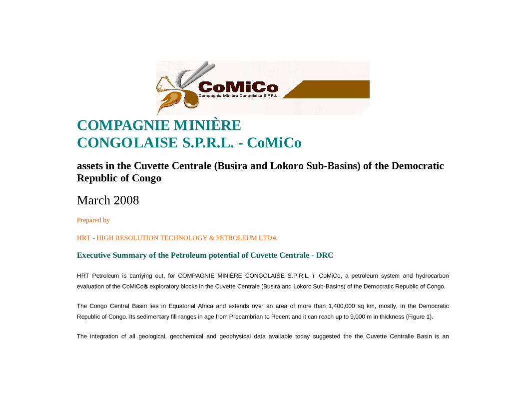
The Congo Central Basin lies in Equatorial Africa and extends over an area of more than 1,400,000 sq km, mostly, in the Democratic
Republic of Congo. Its sedimentary fill ranges in age from Precambrian to Recent and it can reach up to 9,000 m in thickness (Figure 1).
The integration of all geological, geochemical and geophysical data available today suggested the the Cuvette Centralle Basin is an

overcharged petroliferous Basin that could be considered, today, one of the last province in Africa to hold giant to supergiand light oil,
condensate and gas accumulations. The presence of oil seeps widespread around most of the Central Basin suggested an light oil/ gas prone
system. The size of the strutuctural hights, surpassing more than 1000 Km2 together with the presence of at least two active oil systems, in
most of the Basin, indicate that all elements and processes of the petroleum systems are active and works in the Basin.
The basin is a very large intra-continental topographic depression, roughly coinciding with the drainage system of the Congo River and its
tributaries. Its sedimentary infill, is wedge shaped, opening to the east and, by contrast, it onlaps Proterozoic meta-sediments of various
Archean shields, to the North, West and South.
In the eastearn portion, its boundary is erosional and forms the western shoulder of the East African Rift System. Three main sub-basins are
recognized within the Congo Central Basin: the Northeastern Busira and Lomani sub-basins, the Northern Lindian sub-basin and the Central
Lokoro sub-basin. These sub-basins are separated by three basement highs, Inongo, Kiri and Lonkoni.
The seismic data, although scarce, has allowed the identification of a series of huge structural traps. The presence of several oil and gas
seeps widespread around the Basin suggest the presence of multiple Petroleum Systems within the Central Congo Basin. However, only four
wells have been drilled so far and one of them presented oil shows during drilling, corroborating the existence of active petroleum systems
within the area.
At least three petroleum systems have been prooved, using HRGT analyses, to occur in the Cuvette Centrale, one related to the
Cambro-Ordovician sequences and the others to the Siluro-Devonian and Mezozoic age rocks. In order to evaluate the hydrocarbon potential
of the area HRT performed a 2D and 3D petroleum systems modeling with sensibility analysis. The Cambro-Ordovician source rocks,
represented by the Mamungi shale, shows favourable generation potential in the central part of the basin (see Figure 2). The structural map
of this level shows the distribution of the oil prone source rock facies. The areas defined by blue, green and light yellow colors mean good
generation facies (shales) with TOC values above 3%. The areas in dark yellow, orange and red represent sandstones facies with low shale
content.

This source rock distribution was calibrated using geological and geophysical methods (lines L50, L51 and L52). Based on this facies
distribuiton, it is expected the occurrence of the Cambro-Ordovician source rocks within 65% of the Cuvette Centrale area. As a
consequence, it was estimated a potential volume of oil in place between 7.3 and 13 billions barrels and 4 Tcf of gas.
Similar approach was applied to the Siluro-Devonian source rocks, which are represented by the Alolo shale as can be seen in the Figure 3.
Similar to the Cambro-Ordovician source distribution, the Siluro-Devonian source rocks have the main depocenter in the central portion of the
basin. This can be seen in the seismic sections L63, and L51. It is important to mention that, the basin structural evolution has kept the same
depocenter. Therefore this depocenter is the best place to find high thickness and good quality organic matter. This depocenter is well
defined in the seismic lines L50 and L51 (Figures 4 and 5).
As an example, the main exploratory play that would be tested in the Cuvette Centrale, is structurs associated with antithetic normal fault
systems. As observed in Figure 4, four reservoir levels are recognized, from the bottom to the top of the sedimentary column: Proterozoic
limestones (violet horizon), Upper Cambro-Ordovician Arenaceous Sequences (between horizons yellow and light green), Lukunga Formation
(between yellow and dark blue), and Upper Karoo sediments (beige horizon). For these levels, the estimated porosity values varies between
18% to 21%, and the predicted structure size averages around 10 to 30 km2. The expected prospective resources of oil for this lead is up to
800 million barrels for the four levels reservoirs; in this sense, the volume of oil accumulation for each reservoir and the predicted depths are
listed as follows: Upper Karoo, 100 millions barrels, at 1280 meters of depth, Lukunga Formation, 280 millions barrels, at 1760 meters of
depth; Upper Arenaceous Sequence (Cambro-Ordovician), 120 millions barrels, at 3325 meters of depth; and Proterozoic limestone, 230
millions barrels, at 5200 meters of depth.
The map of the Figure 6 shows the distribution of accumulations and oil and gas flowpaths simulation with respective volumes for the
Cambro-Ordovician Upper Arenaceous Sequence.
Observe in the Figure 6 that the biggest potential accumulation is indicated by the letter A, which can bear up to 400 millions barrels. The

accumulation identified by the letter B corresponds with the lead of the Figure 4 and can bear up to 130 millions barrels of prospective
resources. The first HRT studies has identified 21 leads in the Comico’s assets, where at least five of them contained similar geometry and
dimensions to the lead shown in Figure 4.
Another type of identified play was controlled by alternated extensional and compressional phases from the Neo-Proterozoic to Recent times.
These different phases can be observed at the seismic sections. In the example shown in Figure 5, two compressional events are evident.
The older one is associated with the Pan-African deformation (light green horizon represents the Pan-African unconformity) and the last one
is predicted between the Cambro-Ordovician and the Mesozoic ages, as observed in the right portion of the seismic line between 600 and
1700 milliseconds.
This type of play is expected to trap between 180 and 250 millions barrels in structures older than Cambro-Ordovician.
A Juro-Cretaceous petroleum system was also identified, however its potential source rocks presents a low maturity. In order to become a
potential target it will require higher local heat flow anomalies, such as volcanic intrusions.
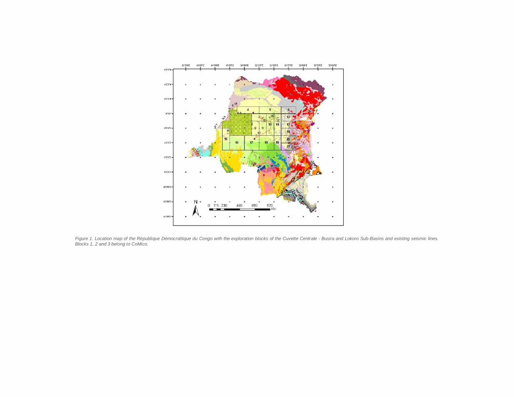
Figure 1. Location map of the République Démocrattique du Congo with the exploration blocks of the Cuvette Centrale - Busira and Lokoro Sub-Basins and existing seismic lines. Blocks 1, 2 and 3 belong to CoMico.
Figure 2. Structural map of the Cambro-Ordovician level with distribution of the oil prone source rock facies. The areas defined by blue, green and light yellow colors mean good generation facies (shales) with TOC values above 3%. The areas in dark yellow, orange and red represents sandstones facies with low shale content. The area of this map encompass all the blocks shown in Figure 1.
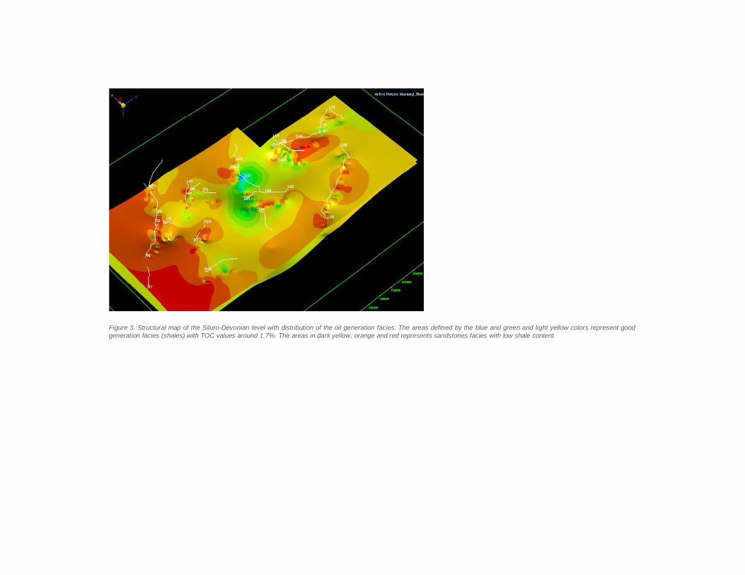
Figure 3. Structural map of the Siluro-Devonian level with distribution of the oil generation facies. The areas defined by the blue and green and light yellow colors represent good generation facies (shales) with TOC values around 1.7%. The areas in dark yellow, orange and red represents sandstones facies with low shale content.
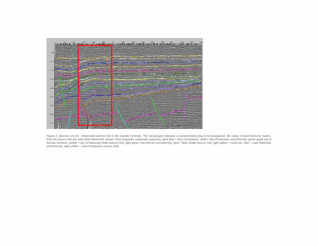
Figure 4. Seismic Line 51 - Interpreted seismic line in the Cuvette Centrale. The red polygon indicates a representative play to be prospected, the colour of each horizons means, from the base to the top: dark pink=basement, brown= Itury evaporitic-carbonate sequence, dark blue = Itury Carbonates, violet= Neo-Proterozoic unconformity, green apple top of Schiste Greseux, yellow = top of Mamungi shale-source rock, light green Pan-African unconformity, pink= Alolo Shale-source rock, light yellow = reservoir, blue = Late Paleozoic unconformity, dark yellow = Juro-Cretaceous source rock)
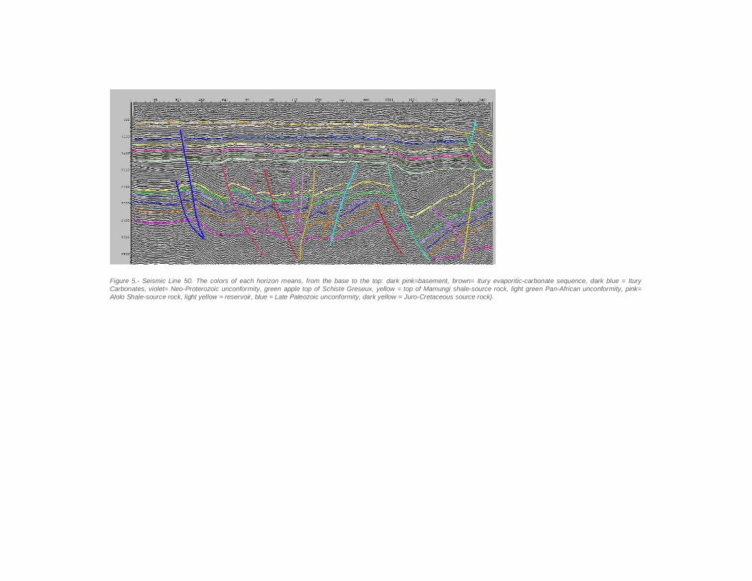
Figure 5.- Seismic Line 50. The colors of each horizon means, from the base to the top: dark pink=basement, brown= Itury evaporitic-carbonate sequence, dark blue = Itury Carbonates, violet= Neo-Proterozoic unconformity, green apple top of Schiste Greseux, yellow = top of Mamungi shale-source rock, light green Pan-African unconformity, pink= Alolo Shale-source rock, light yellow = reservoir, blue = Late Paleozoic unconformity, dark yellow = Juro-Cretaceous source rock).
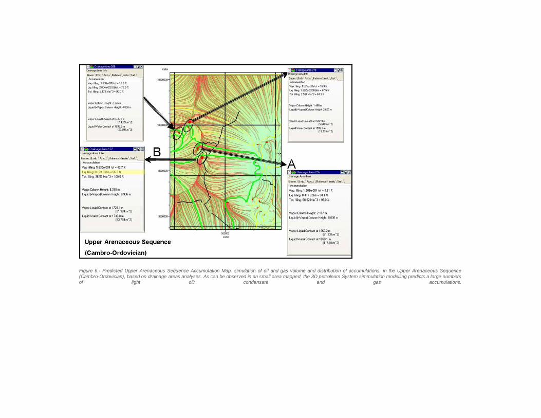
Figure 6.- Predicted Upper Arenaceous Sequence Accumulation Map. simulation of oil and gas volume and distribution of accumulations, in the Upper Arenaceous Sequence (Cambro-Ordovician), based on drainage areas analyses. As can be observed in an small area mapped, the 3D petroleum System simmulation modelling predicts a large numbers of light oil/ condensate and gas accumulations.

Presentation