Embed Size (px)
Citation preview
624 Danilo P. da Silva et al.
R. Bras. Eng. Agríc. Ambiental, v.16, n.6, p.624–631, 2012.
1 DEBI/UESB, Rodovia BR 415, Km 03 SN, CEP 45700-000 Itapetinga, BA. Fone: (77) 3261 8680 Email: [email protected] DEA/UFV, Av. P. H. Rolfs SN, CEP 36570-000 Viçosa, MG. Email: [email protected]; [email protected]; [email protected]
Comparative analysis of models for designof infiltration basins in unpaved roads
Danilo P. da Silva1, Fernando F. Pruski2,José M. A. da Silva2 & Waldir D. M. Meireles Filho2
ABSTRACTUnpaved roads are of great importance for the economic and social development of a country. Watererosion provoked by the concentration of runoff along the road is a principle cause of its degradation.The construction of infiltration basins for runoff retention on unpaved roads is a usually alternative for theproblem solution. The use of more coherent methodologies for designing infiltration basins is fundamentalfor the appropriate road degradation processes control. Therefore, the objective of this work was toperform a comparative analysis of a methodology for the design of infiltration basins that consider anintense rainfall associated to a determined return period, with a methodology that use all events of adetermined precipitation series, and overlapping effects of their respective runoff volumes. According tothe obtained results, it was found that the volume calculated for the infiltration basin by the model whichconsiders all events of the precipitation series is greater when the rate of water infiltration into the soil atthe basin bottom is lowest.
Key words: road erosion, retention basin, detention basin, best management practices, syntheticprecipitation series
Análise comparativa de modelos para dimensionamentode bacias de infiltração em estradas não pavimentadas
RESUMOEstradas não pavimentadas são imprescindíveis para o desenvolvimento econômico e social de um país.A erosão provocada pela concentração do escoamento superficial ao longo da estrada é a principalcausa da sua degradação. A construção de bacias de infiltração para reter o volume do escoamentosuperficial proveniente das estradas não pavimentadas, consiste em uma alternativa comumenteempregada para a solução do problema. O uso de metodologias mais coerentes para o dimensionamentode bacias de infiltração é fundamental para controlar, de forma mais adequada, o processo de degradaçãodas estradas. Assim, o objetivo deste trabalho foi a realização de uma análise comparativa de umametodologia para o dimensionamento de bacias de infiltração, que considera uma chuva intensa associadaa determinado período de retorno, com uma metodologia que pondera uma série histórica de eventosde precipitação. Evidenciou-se, de acordo com os resultados obtidos, que o volume da bacia de infiltraçãocalculado pelo modelo que leva em consideração todos os eventos da série de precipitação, é maiorquando a taxa de infiltração da água no solo no fundo da bacia é menor.
Palavras-chave: erosão em estradas, bacias de retenção, bacias de detenção, práticas conservacionistas,série sintética de precipitação
Revista Brasileira deEngenharia Agrícola e Ambientalv.16, n.6, p.624–631, 2012Campina Grande, PB, UAEA/UFCG – http://www.agriambi.com.brProtocolo 164.11 – 08/08/2011 • Aprovado em 28/03/2012
625Comparative analysis of models for design of infiltration basins in unpaved roads
R. Bras. Eng. Agríc. Ambiental, v.16, n.6, p.624–631, 2012.
INTRODUCTION
Unpaved roads, also known as unsealed roads or rural roads,are of great importance for the economic and socialdevelopment of a country (Lugo & Gucinski, 2000; Crossley etal., 2001; Carvalho et al., 2010). Their existence enable the accessof rural population to health services, education, leisure(Gallego et al., 2008a), and transport of agricultural, stock-raisingand products of forestry activities (Gallego et al., 2008b).
Water erosion is one of the major factors influencingunpaved roads deterioration (Egan, 1999; Rummer et al., 2000;Machado et al., 2003). Apart from roadbed deterioration,unpaved roads in inappropriate conditions can both lead andaggravate erosion processes in agricultural areas (Jungeriuset al., 2002; Nyssen et al., 2002). Furthermore, this process maycause silting and pollution of watercourses (Grace III, 2002;Motha et al., 2004; Forsyth et al., 2006; Thompson et al., 2010).
Due to the role of runoff as the main agent of unpavedroads erosion, its drainage before flow concentration anderosive energy acquirement is of fundamental importance forpreventing accentuated damages to the roads (Griebeler et al.,2005). However, the simple act of removing water from roads isnot sufficient in the absence of appropriate destination for theflow, which would resume in transferring the problem to roadmarginal areas. Therefore, the construction of infiltration basinsfor runoff retention on unpaved roads is alternative of greatimportance for the control of degradation processes on theseroads.
For designing infiltration basins, normally only a singleintense rainfall is considered, such as in methodologydeveloped by Pruski et al. (1997). In order to developappropriate methodology for designing infiltration basin, Silva(2009) proposed a model based not only on one rainfall event,but all events of historical series at the place of interest andconsequently, the cumulative effect of its respective runoffevents throughout the series.
Based on hypothesis that calculation of required volumeto infiltration basins, the adoption of criteria that takes intoaccount the analysis event to event of precipitation is moreconsistent than one based at a single event associated with areturn period of project, this work aims to conduct a comparativeanalysis of the model developed by Silva (2009) (based onevent to event analysis) with the one developed by Pruski etal. (1997) (based on a single event).
MATERIAL AND METHODS
The model proposed by Pruski et al. (1997), called the SoilSurface Water Balance Method (Pruski, 2009), obtains themaximum runoff volume to be retained by the basin consideringthe maximum rainfall for a given project return period, such asseveral other methods developed for designing infiltrationbasins. The model proposed by Silva (2009) is based on a newconcept for designing infiltration basins, which takes intoaccount not only one rainfall event, but all historical seriesevents at the place of interest, as well as the overlapping effectsof their respective runoff volumes.
Soil surface water balance method (Pruski et al., 1997)The Soil Surface Water Balance Method (SSWB) (2005) was
developed in order to obtain the maximum surface runoff depth(MRD, in mm). In this model, the volume required for theinfiltration basin (VB) is derived from the product of MRD(converted to m) by the road area contributing (m2) to theinfiltration basin.
To obtain MRD a physical model of water balance on soilsurface water was used as described by:
MRD = R – Ia – F
where:R - total rainfall depth, mmIa - initial abstraction, mmF - accumulation infiltration, mm
The total rainfall depth corresponding to a time interval t(min) was obtained by:
R = im t60
where:im - average maximum rainfall intensity, mm h-1 (which is
constant for a given rainfall and time duration)t - rainfall duration (min)
To obtain im, the classical rainfall intensity-duration-frequency relationship was used:
im=K Ta
(b + t)c
where:a, b, c, K - parameters of the precipitation profile equation,
dimensionless
Substituting Eq. 3 into Eq. 2 and taking the derivative withrespect to time, the instantaneous rainfall intensity (iint), inmm h-1, is obtained:
iint = im 1−c t
t + b
Both im and iint decrease as t increases. The MSR ends at theinstant at which iint is equal water infiltration into the soil of theroadbed (INFR). Under this condition:
im 1−c t
t + b- INFR = 0
The t value corresponding to MSR was obtained using theNewton-Raphson method.
The values of initial abstraction were determined by thecurve number method, using the equation (SCS, 1972):
(1)
(2)
(3)
(4)
(5)
626 Danilo P. da Silva et al.
R. Bras. Eng. Agríc. Ambiental, v.16, n.6, p.624–631, 2012.
Ia = 50,8 100CN
- 1
where CN is the curve number.
The time corresponding to the initial abstraction wasobtained using:
tIa=Ia 60
im
where tIa is the time interval from the beginning of the rain tothe beginning of the of runoff (min)
F =INFR tinf
60
where:INFR - rate of water infiltration into the soil of the roadbed,
mm h-1
tinf - infiltration period, min (obtained from the equationtinf = t – tIa)
Model proposed by Silva (2009)This model uses synthetic precipitation data obtained from
the ClimaBr model, developed by Oliveira et al. (2005a; 2005b)and refined by Zanetti et al. (2005) and Baena et al. (2005). Froma historical series of rainfall data the ClimaBr model generatesthe following variables: total precipitated depth, total rainfallduration, time of maximum intensity rainfall and parametersrelated to the precipitation profile.
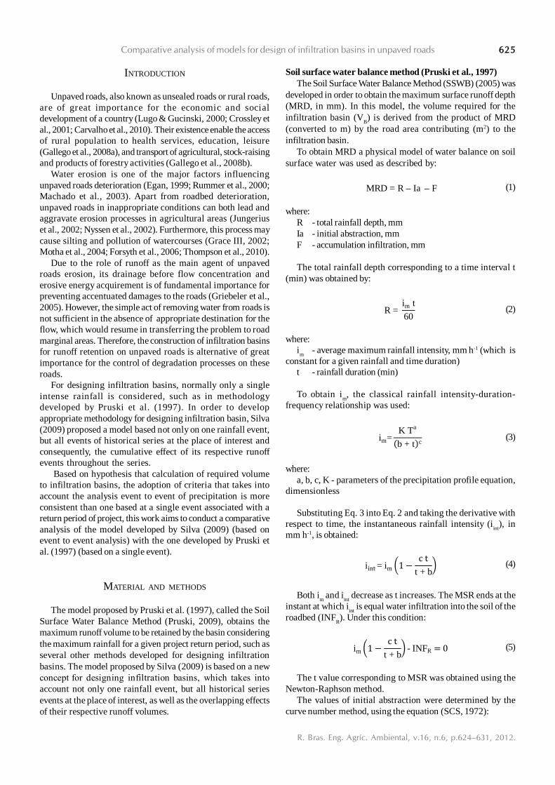
The precipitation profile considered in ClimaBr is describedby a double exponential function (Figure 1) that represents thevariation of the instantaneous precipitation intensity (ii) as afunction of time (t).
A double exponential function that represents the precipi-tation profile is given as:
ii = a' eb' t 0 ≤ t ≤ timax
c' e-d' t timax < t ≤ 1,0
where:a’, b’, c’, d’ - parameters of the double exponential function
in relation to the precipitation event, dimensionlesstimax - time of occurrence of the maximum instantaneous
precipitation intensity, dimensionless
From the daily series of rainfall data, calculations areperformed to obtain the daily runoff volume. The runoff volume(RV) is derived from the product of runoff depth (RD) by theroad area contributing to the infiltration basin.
In the determination of RD it is assumed that runoff startswhen ii is greater than the rate of water infiltration into the soilof the roadbed (INFR) at time tb, and ends when ii returns to beequal to INFR, at time te (Figure 1).
The precipitation depth occurring in the interval betweenthe times tb and te is obtained from the sum of the value resultingfrom the integration of the area corresponding to the ascendingbranch of the precipitation profile, tb to timax, and the areacorresponding to the descending branch, timax to te (Figure 1).The value of RD is derived from the difference between theprecipitation depth occurring during the time interval from tband te, and the infiltration depth occurring in the roadbed overthe same time interval. The infiltration depth is obtained fromthe product of INFR by the time interval in which surface runoffoccurs (te - tb).
The volume stored in the infiltration basin on a given day ofthe series (VS i) is obtained from the total volume of runoffreaching the basin that day (RVi) and the stored volumeremaining from the previous day (VRi - 1). These volumes areobtained by the equations:
Figure 1. Precipitation profile as a double exponential function
(6)
(7)
(8)
(9)
627Comparative analysis of models for design of infiltration basins in unpaved roads
R. Bras. Eng. Agríc. Ambiental, v.16, n.6, p.624–631, 2012.
VS i = RV i + VR i-1
In the first rainfall of the series, which corresponds to thebeginning of the simulations, the value of VS is equal to thevolume of runoff that occurs on this day. If this volume doesnot completely infiltrate to the bottom of the basin that day,part of this volume will remain in the basin, corresponding tothe value of VR i-1 for the next day.
The values of VR i-1 are directly related to the geometricalcharacteristics of the basin (width and slopes) and the waterinfiltration rate into the soil at the bottom of the basin (INFB).Basins that have lower embankment slopes and greater widthtend to have a greater surface area of liquid when full, a factwhich implies a greater infiltrated volume for the same INFB.
The VS values calculations are repeated for all days in theseries, in order to obtain a daily series of volumes stored. Ineach year the highest value of VS from the series is identified,which provides an annual series of maximum volumes storedin the infiltration basin (Vmax).
The volume required for the infiltration basin (VB) is obtainedby applying the Gumbel distribution to the series of maximumstored volumes. According to the methodology proposed byKite (1988), to calculate the magnitude of an event for finiteseries the value of VB is calculated from the following equation:
VB = Vmax + K' σ
where:Vmax - average of the maximum storage volume, m3
K’ - frequency factor, dimensionless - standard deviation of the maximum quantity stored in
each year of the series, dimensionless
The frequency factor for the finite series is calculated asfollows:
K' = - 0,45 + 0,7797 ln – ln 1- 1T
where T is the return period, years.
Comparative analysis of modelsThe analyses were made based on comparison of VB values
obtained by two models. The VB values were calculatedconsidering five return periods (5, 10, 15, 18 and 20 years) andfive values of water infiltration rate through the basin bottomsoil – INFB (2, 5, 10, 15 and 20 mm h-1). The comparison of theVB values was separately made for each INFB value, since thisvariable is not considered in the model proposed by Pruski etal. (1997).
For both models it was considered that runoff is generatedonly by the drainage area comprised of the roadbed andcorresponding to 300 m2, allowing for a water infiltration rate inthe roadbed (INFR) of 1 mm h-1. The considered infiltrationbasin was rectangular shaped with a width (LB) of 6 m and
downstream (s1) and upstream (s2) slope declivities of 1 and0.5 m m-1
, respectively.In the comparative analysis of the models, were considered
precipitation data from the João Pinheiro and São Gonçalo doAbaeté towns, both from Minas Gerais State, Brazil, andlocalized into of the Paracatu watershed.
RESULTS AND DISCUSSION
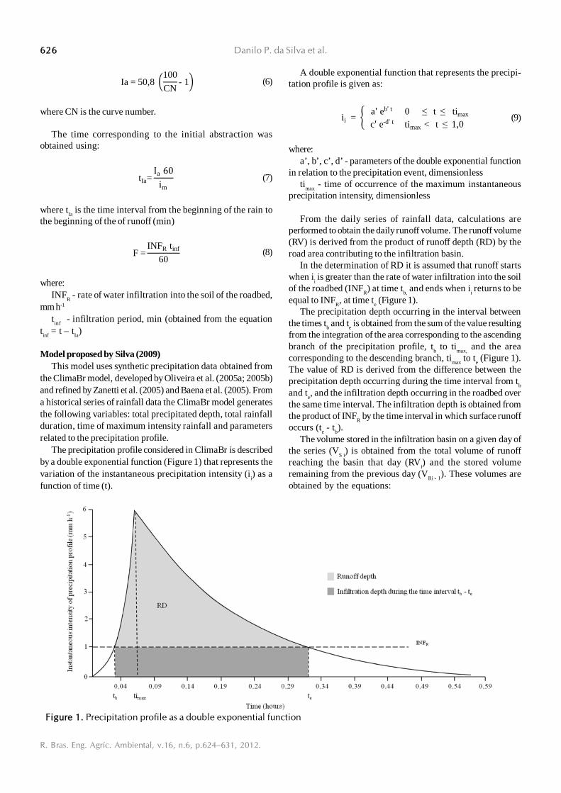
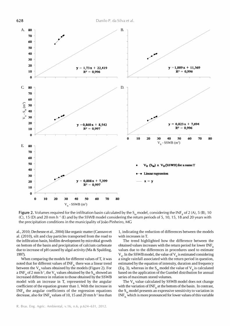
Figure 2 shows a comparison between the VB for differentvalues of INFB calculated by the model developed by Silva(2009) (SM) and those calculated by the model developed byPruski et al. (1997) (SSWB). Relations considering differentvalues of T were obtained for each INFB studies with regard toprecipitation conditions in the municipality of João Pinheiro.The lines shown in the figure relate the identity function andthe linear regression fitted to the VB points calculated by theSM model versus the VB calculated by the SSWB model.
In the SM model, the effect of overlapping runoff events onvolumes stored during each day of the series is taken intoaccount and, consequently, it influences the volume requiredfor the infiltration basin. The SSWB model only takes intoconsideration one event associated with the determined returnperiod without taking into account the fact that there are manyevents throughout the series where the runoff volume doesnot completely infiltrate the soil during a given day, and thatthe infiltration of volumes over a rainy season may represent amore critical condition for the design of the infiltration basinthan the volume resulting from a single rainfall, as consideredby the SSWB model.
The comparison between the models for different INFBvalues shows that lower INFB values resulted in greaterdifferences in the VB calculated by the two models. For a INFBof 2 mm h -1, it was noted that the VB values obtained by the SMmodel estimated higher VB values, the magnitude of which was2.65 times higher on average than the values obtained by theSSWB. For INFB of 5, 10, 15 and 20 mm h-1, differences of 1.48,1.21, 1.14 and 1.11 times greater were noted on average,respectively.
This behavior is the result of a more accentuated effect ofoverlapping runoff events when INFB is lower, making thevolumes stored in the basin and, consequently, the value of VBcalculated by the SM model larger. Because The SSWB modeldoes not consider this characteristic, the difference betweenthe VB values calculated by the models increases.
Studies relating the water infiltration rate into the soil at thebottom of the infiltration basin are still very scarce. However, itis anticipated that consideration of smaller values of thisvariable are more representative for the majority of the cases,even when dealing with infiltration basins constructed of soilswith good infiltration capacity. This affirmation is based on thefact that there are processes which expressively interfere inthe reduction of basin infiltration rates, such as: i) compactionof the soil at the base by tractor tires during construction suchas illustrated by Miranda et al. (2009) and from the weight ofthe basin water (Ma & Spalding, 1997); and ii) soil surfacesealing by the suspended solids accumulation (Lassabatere et
(10)
(11)
(12)
628 Danilo P. da Silva et al.
R. Bras. Eng. Agríc. Ambiental, v.16, n.6, p.624–631, 2012.
Figure 2. Volumes required for the infiltration basin calculated by the SM model, considering the INFB of 2 (A), 5 (B), 10(C), 15 (D) and 20 mm h -1 (E) and by the SSWB model considering the return periods of 5, 10, 15, 18 and 20 years withthe precipitation conditions in the municipality of João Pinheiro, MG
al., 2010; Dechesne et al., 2004) like organic matter (Cannavo etal. (2010), silt and clay particles transported from the road tothe infiltration basin, biofilm development by microbial growthon bottom of the basin and precipitation of calcium carbonatedue to increase of pH caused by algal activity (Ma & Spalding,1997).
When comparing the models for different values of T, it wasnoted that for different values of INFB, there was a linear trendbetween the VB values obtained by the models (Figure 2). Fora INFB of 2 mm h-1, the VB values obtained by the SM showed anincreased difference in relation to those obtained by the SSWBmodel with an increase in T, represented by the angularcoefficient of the equation greater than 1. With the increase inINFB the angular coefficients of the regression equationsdecrease, also for INFB values of 10, 15 and 20 mm h-1 less than
1, indicating the reduction of differences between the modelswith increases in T.
The trend highlighted how the difference between theobtained values increases with the return period for lower INFBvalues due to the differences in procedures used to estimateVB. In the SSWB model, the value of VB is estimated consideringa single rainfall associated with the return period in question,estimated by the equation of intensity, duration and frequency(Eq. 3), whereas in the SM model the value of VB is calculatedbased on the application of the Gumbel distribution for annualseries of maximum stored volumes.
The VB value calculated by SSWB model does not changewith the variation of INFB at the bottom of the basin.. In contrast,the SM model presents an expressive sensitivity to variation inINFB, which is more pronounced for lower values of this variable
VB - SSWB (m3)
VB - SSWB (m3)
VB -
S M (m
3 )
A. B.
C. D.
E.
629Comparative analysis of models for design of infiltration basins in unpaved roads
R. Bras. Eng. Agríc. Ambiental, v.16, n.6, p.624–631, 2012.
(Silva, 2009). Thus, for the same value of T, while the VB valueremains constant using the SSWB model, there is aconsiderable variation in the SM model, which is morepronounced for lower values of INFB.
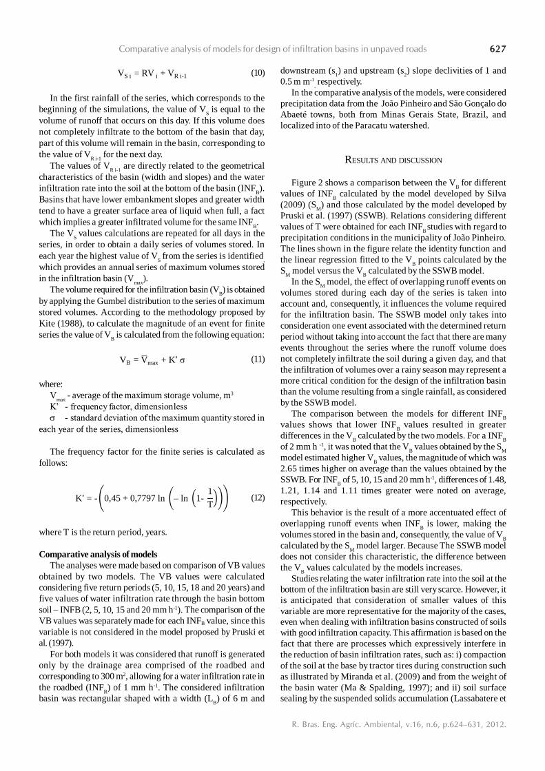
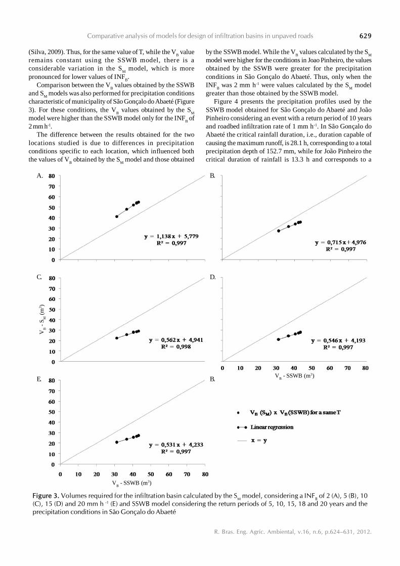
Comparison between the VB values obtained by the SSWBand SM models was also performed for precipitation conditionscharacteristic of municipality of São Gonçalo do Abaeté (Figure3). For these conditions, the VB values obtained by the SMmodel were higher than the SSWB model only for the INFB of2 mm h-1.
The difference between the results obtained for the twolocations studied is due to differences in precipitationconditions specific to each location, which influenced boththe values of VB obtained by the SM model and those obtained
by the SSWB model. While the VB values calculated by the SMmodel were higher for the conditions in Joao Pinheiro, the valuesobtained by the SSWB were greater for the precipitationconditions in São Gonçalo do Abaeté. Thus, only when theINFB was 2 mm h-1 were values calculated by the SM modelgreater than those obtained by the SSWB model.
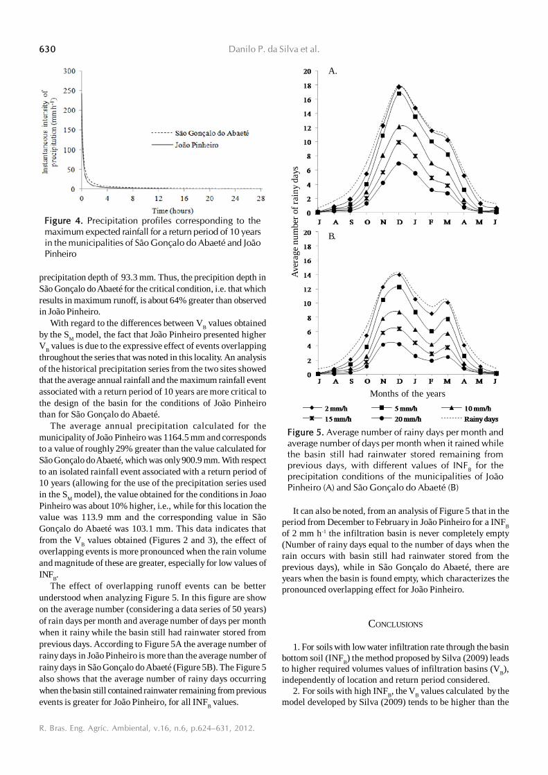
Figure 4 presents the precipitation profiles used by theSSWB model obtained for São Gonçalo do Abaeté and JoãoPinheiro considering an event with a return period of 10 yearsand roadbed infiltration rate of 1 mm h-1. In São Gonçalo doAbaeté the critical rainfall duration, i.e., duration capable ofcausing the maximum runoff, is 28.1 h, corresponding to a totalprecipitation depth of 152.7 mm, while for João Pinheiro thecritical duration of rainfall is 13.3 h and corresponds to a
Figure 3. Volumes required for the infiltration basin calculated by the SM model, considering a INFB of 2 (A), 5 (B), 10(C), 15 (D) and 20 mm h -1 (E) and SSWB model considering the return periods of 5, 10, 15, 18 and 20 years and theprecipitation conditions in São Gonçalo do Abaeté
VB - SSWB (m3)
VB - SSWB (m3)
VB -
S M (m
3 )
A. B.
C. D.
E. B.
630 Danilo P. da Silva et al.
R. Bras. Eng. Agríc. Ambiental, v.16, n.6, p.624–631, 2012.
precipitation depth of 93.3 mm. Thus, the precipition depth inSão Gonçalo do Abaeté for the critical condition, i.e. that whichresults in maximum runoff, is about 64% greater than observedin João Pinheiro.
With regard to the differences between VB values obtainedby the SM model, the fact that João Pinheiro presented higherVB values is due to the expressive effect of events overlappingthroughout the series that was noted in this locality. An analysisof the historical precipitation series from the two sites showedthat the average annual rainfall and the maximum rainfall eventassociated with a return period of 10 years are more critical tothe design of the basin for the conditions of João Pinheirothan for São Gonçalo do Abaeté.
The average annual precipitation calculated for themunicipality of João Pinheiro was 1164.5 mm and correspondsto a value of roughly 29% greater than the value calculated forSão Gonçalo do Abaeté, which was only 900.9 mm. With respectto an isolated rainfall event associated with a return period of10 years (allowing for the use of the precipitation series usedin the SM model), the value obtained for the conditions in JoaoPinheiro was about 10% higher, i.e., while for this location thevalue was 113.9 mm and the corresponding value in SãoGonçalo do Abaeté was 103.1 mm. This data indicates thatfrom the VB values obtained (Figures 2 and 3), the effect ofoverlapping events is more pronounced when the rain volumeand magnitude of these are greater, especially for low values ofINFB.
The effect of overlapping runoff events can be betterunderstood when analyzing Figure 5. In this figure are showon the average number (considering a data series of 50 years)of rain days per month and average number of days per monthwhen it rainy while the basin still had rainwater stored fromprevious days. According to Figure 5A the average number ofrainy days in João Pinheiro is more than the average number ofrainy days in São Gonçalo do Abaeté (Figure 5B). The Figure 5also shows that the average number of rainy days occurringwhen the basin still contained rainwater remaining from previousevents is greater for João Pinheiro, for all INFB values.
Figure 4. Precipitation profiles corresponding to themaximum expected rainfall for a return period of 10 yearsin the municipalities of São Gonçalo do Abaeté and JoãoPinheiro
Figure 5. Average number of rainy days per month andaverage number of days per month when it rained whilethe basin still had rainwater stored remaining fromprevious days, with different values of INFB for theprecipitation conditions of the municipalities of JoãoPinheiro (A) and São Gonçalo do Abaeté (B)
It can also be noted, from an analysis of Figure 5 that in theperiod from December to February in João Pinheiro for a INFBof 2 mm h-1 the infiltration basin is never completely empty(Number of rainy days equal to the number of days when therain occurs with basin still had rainwater stored from theprevious days), while in São Gonçalo do Abaeté, there areyears when the basin is found empty, which characterizes thepronounced overlapping effect for João Pinheiro.
CONCLUSIONS
1. For soils with low water infiltration rate through the basinbottom soil (INFB) the method proposed by Silva (2009) leadsto higher required volumes values of infiltration basins (VB),independently of location and return period considered.
2. For soils with high INFB, the VB values calculated by themodel developed by Silva (2009) tends to be higher than the
Aver
age
num
ber o
f rai
ny d
ays
Months of the years
A.
B.
631Comparative analysis of models for design of infiltration basins in unpaved roads
R. Bras. Eng. Agríc. Ambiental, v.16, n.6, p.624–631, 2012.
model proposed by Pruski et al. (1997), when the events overlapeffect is higher.
3. For soils with high INFB, the return period effect in the VBvalues is higher in the model proposed by Pruski et al. (1997)than the model proposed by Silva (2009).
ACKNOWLEDGMENTS
The authors would like to thank Conselho Nacional deDesenvolvimento Científico e Tecnológico - CNPq (Brazil), andFundação de Amparo à Pesquisa do Estado de Minas Gerais -FAPEMIG (Minas Gerais state, Brazil), for providing necessaryfunds to conduct this work.
LITERATURE CITED
Baena, L. G. N.; Pruski, F. F.; Moreira, M. C.; Souza, V. B. C.;Zanetti, S. S.; Oliveira, V. P. S. Programa computacional parageração de séries de dados climáticos. Revista Engenhariana Agricultura, v.13, p.210-220, 2005.
Cannavo, P.; Vidal-Beaudet, L.; Béchet, B.; Lassabatère, L.;Charpentier, S. Spatial distribution of sediments and transferproperties in soils in a stormwater infiltration basin. Journalof Soils Sediments, v.10, p.1499-1509, 2010.
Carvalho, W. L.; Cruz, R. O. M.; Camara, M. T.; Aragão, J. J. G.Rural school transportation in emerging countries: The Braziliancase. Research in Transportation Economics, v.30, p.1-9, 2010.
Crossley, C. P.; Kibiwot, V. N.; Reynolds, A. J.; Rickson, R. J.Rut formation and rolling resistance on earth roads. Journalof Agricultural Engineering Research, v.78, p.99-107, 2001.
Dechesne, M.; Barraud, S.; Bardin, J. P. Indicators for hydraulic andpollution retention assessment of stormwater infiltration basins,Journal of Environmental Management, v.71, p.371-380, 2004.
Egan, A. F. Forest roads: Mere soil and water don’t mix. Journalof Forest, v.97, p.18-21, 1999.
Forsyth, A. R.; Bubb, K. A.; Cox, M. E. Runoff, sediment lossand quality from forest roads in a southeast Queenslandcoastal plain Pinus plantation. Forest Ecology andManagement, v.221, p.194-206, 2006.
Gallego, E.; Moya, M.; Piniés, M.; Ayuga, F. Valuation of lowvolume roads in Spain. Part 1: Methodology development.Biosystems Engineering, v.101, p.123-134, 2008a.
Gallego, E.; Moya, M.; Piniés, M.; Ayuga, F. Valuation of lowvolume roads in Spain. Part 2: Methodology validation.Biosystems Engeneering, v.101, p.135-142, 2008b.
Grace III, J. M. Sediment movement from forest road systems.Resource, v.9, p.13-14, 2002.
Griebeler, N. P.; Pruski, F. F.; Silva, J. M. A.; Ramos, M. M.;Silva, D. D. Model to determine the spacing between wateroutlets in unpaved roads. Revista Brasileira de Ciência doSolo, v.29, p.397-405, 2005.
Jungerius, P. D.; Matundura, J.; Ancker, J. A. M. Roadconstruction and gully erosion in west Pokot, Kenya. EarthSurface Processes and Landforms, v.27, p.1237-1247, 2002.
Kite, G. W. Frequency and risk analysis in hydrology. 5.ed.Highlands Ranch: Water Resources Publications, 1988. 257p.
Lassabatere, L.; Angulo-Jaramillo, R.; Goutaland, D.; Letellier,L.; Gaudet, J. P.; Winiarski, T.; Delolme, C. Effect of thesettlement of sediments on water inûltration in two urbaninfiltration basins. Geoderma, v.156, p.316-325, 2010.
Lugo, A. E.; Gucinski, L. H. Function, effects, and managementof forest roads. Forest Ecology and Management, v.133,p.249-262, 2000.
Ma, Li; Spalding, R. F. Effects of artificial recharge on groundwater quality and storage recovery. Journal of the AmericanWater Resources Association, v.33, p.561-572, 1997.
Machado, C. C.; Garcia, A. R.; Silva, E.; Fontes, A. M.Comparison of erosion rates in forest roads applying theWEPP model (Water Erosion Prediction Project) modifiedwith reference to experimental measurements. Revista Árvore,v.27, p.295-300, 2003.
Miranda, A. C. R.; Silva, D. P.; Mello, E. L.; Pruski, F. F.Implantação, avaliação e monitoramento de práticasmecânicas para a conservação de solo e água. In: FernandoFalco Pruski. (Org.). Conservação do solo e água: Práticasmecânicas para o controle de erosão hídrica. 2 ed. Viçosa:Editora UFV, 2009. Cap.8, p.216-259.
Motha, J. A.; Wallbrink, P. J.; Hairsine, P. B.; Grayson, R. B.Unsealed roads as suspended sediment sources in anagricultural catchment in south-eastern Australia. Journalof Hydrology, v.286, p.1-18, 2004.
Nyssen, J.; Poesen, J.; Moeyersons, J.; Luyten, E.; Veyret-Picot, M. ; Deckers, J.; Haile, M.; Govers, G. Impact of roadbuilding on gully erosion risk: a case study from the northernEthiopian highlands. Earth Surface Processes andLandforms, v.27, p.1267- 1283, 2002.
Oliveira, V. P. S.; Zanetti, S. S.; Pruski, F. F. CLIMABR Part II:Generation of precipitation profile. Revista Brasileira deEngenharia Agrícola e Ambiental, v.9, p.355-349, 2005a.
Oliveira, V. P. S.; Zanetti, S. S.; Pruski, F. F. CLIMABR Part I:Model for generation of synthetic series of precipitation.Revista Brasileira de Engenharia Agrícola e Ambiental, v.9,p.356-363, 2005b.
Pruski, F. F. Conservação de solo e água: Práticas mecânicaspara o controle da erosão hídrica. 2.ed. Viçosa: UFV, 2009.279p.
Pruski, F. F.; Ferreira, P. A.; Ramos, M. M.; Cecon, P. R. Modelto design level terraces. Journal of Irrigation and DrainageEngineering, v.123, p.8-12, 1997.
Rummer, B.; Stokes, B.; Lockaby, G. Sedimentation associated withforest road surfacing in a bottomland hardwood ecosystem.Forest Ecology and Management, v.90, p.195-200, 2000.
SCS - Soil Conservation Service. National engineering handbook,section 4: Hydrology. Washington: USDA, 1972. 115p.
Silva, D. P. Modelo de dimensionamento de bacias de acumulaçãopara estradas. Viçosa: UFV, 2009. 57p. Dissertação Mestrado
Thompson, M.; Sessions, J.; Boston, K.; Skaugset, A.;Tomberlin, D. Forest road erosion control using multiobjectiveoptimization. Journal of the American Water ResourcesAssociation, v.46, p.712-723, 2010.
Zanetti, S. S.; Pruski, F. F.; Moreira, M. C.; Sediyama, G. C.;Silva, D. D. Software for generation of synthetic series ofprecipitation. Engenharia Agrícola, v.25, p.96-104, 2005.