Embed Size (px)
Citation preview

Acta Geodyn. Geomater., Vol. 14, No. 2 (186), 145–152, 2017
DOI: 10.13168/AGG.2016.0035
journal homepage: https://www.irsm.cas.cz/acta
ORIGINAL PAPER
COMPARISON OF SEASONAL HYDROLOGIC VARIATIONS IN THE LA PLATA BASIN FROM GRACE MONTHLY SOLUTIONS WITH IN SITU TIDE
GAUGE WATER LEVEL DATA
Annamária KISS 1) * and Lóránt FÖLDVÁRY 2, 3)
1) Department of Geodesy and Surveying, Budapest University of Technology and Economics, Műegyetem rkp. 3., 1111 Budapest, Hungary
2) Institute of Geoinformatics, Alba Regia Technical Faculty, Óbuda University, Budai út 45., 8000 Székesfehérvár, Hungary 3) Geodetic and Geophysical Institute, Research Centre of Astronomical and Earth Sciences, Hungarian Academy of Science,
Csatkai Endre u. 6-8, 9400 Sopron, Hungary
*Corresponding author‘s e-mail. [email protected]
ABSTRACT
Seasonal hydrologic variations have been determined in the La Plata basin from GRACEmonthly solutions for a time span of less than 6 years. The results have been compared to tidegauge water level data along several rivers of the La Plata basin. Annual and semi-annual curveshave been fitted both to the GRACE water storage variation series and to the tide gauge waterlevel series, correlations between the original series and the curves have been determined,relationship of the amplitudes and phases have been investigated. The aim of the comparison isto detect time delay between the seasonal cycle of precipitation (related to GRACE) and runoff(observed by tide gauges). The time delay may deliver information on water storage, such asgroundwater aquifers, soil moisture or canopy interception. As for the results, by the comparisonof the annual phases, 11-13 days of time delay between GRACE data and tide gauge data hasbeen detected.
ARTICLE INFO
Article history:
Received 3 August 2016 Accepted 27 October 2016 Available online 8 November 2016
Keywords: Water storage variation GRACE Tide gauge
storage. After removing the mean field, which isdominated by the static density distribution inside thesolid Earth, changes of the vertically integratedterrestrial water storage can be determined (Ilk et al.,2005). As inside a basin GRACE data is characterizedby the seasonal hydrologic mass variations,relationship with the seasonal variations of the runoffalong the rivers of the catchment area can beexpected. In this study water storage variations havebeen determined from GRACE models in the SouthAmerican La Plata basin between 2002 and 2008, andcompared with tide gauge water levels along the mainrivers of the basin, with particular emphasis on theseasonal trends.
Earlier studies for the La Plata basin have beendelivered by Pereira and Pacino (2012) and Pereira etal. (2012). Both studies deliver a regional analysis ofhydrological processes based on GRACE monthlysolutions. The present study does not focus on thewhole basin as a region, instead point-wisecomparison of the satellite derived data with tidegauge water level observations is performed. Thedifference of the two observations is expected toprovide information on the water storage variations,since tide gauge observes the real time runoffs, whileGRACE reflects all mass variations over the region,including the subsurface water variations as well.Some incomplete investigations have already been
1. INTRODUCTION
The Earth’s constantly changing massdistribution varies its gravity field over time (Wahrand Schubert, 2007). Large-scale mass variations aregenerated by huge mass redistributions over largeareas, such as conventions in the core and in themantle, tectonic processes, earthquakes and volcanoactivity, tidal deformations of crust and oceans,circulations in the atmosphere and in the oceans, thehydrologic cycle, cryospheric processes, de-glaciationor the global sea level rise. Among them, seasonalvariations are mainly generated by massredistributions of the atmosphere, oceans andhydrologic processes.
The GRACE (Gravity Recovery And ClimateExperiment) satellites have been providing globalgravity field models with monthly resolution foralmost 15 years, enabling the investigation of seasonalmass variations. The largest impact on seasonalgravity variations is generated by the atmosphere,which is concerned to be quite well-measured due tothe dense, worldwide barometric network. For mostGRACE applications, atmospheric redistributionprocesses are taken into account as a correction, whichis found to be done in the official GRACE outputswith sufficient accuracy (Zenner et al., 2012). Overthe land, the remaining seasonal mass variation isaffected mainly by changes of the terrestrial water
Cite this article as: Kiss A, Fӧldváry L: Comparison of seasonal hydrologic variations in the La Plata basin from GRACE monthly solutionswith in situ gauge water level data. Acta Geodyn. Geomater., 14, No. 2 (186), 145–152, 2017.
DOI: 10.13168/AGG.2016.0035
A. Kiss and L. Fӧldváry
146
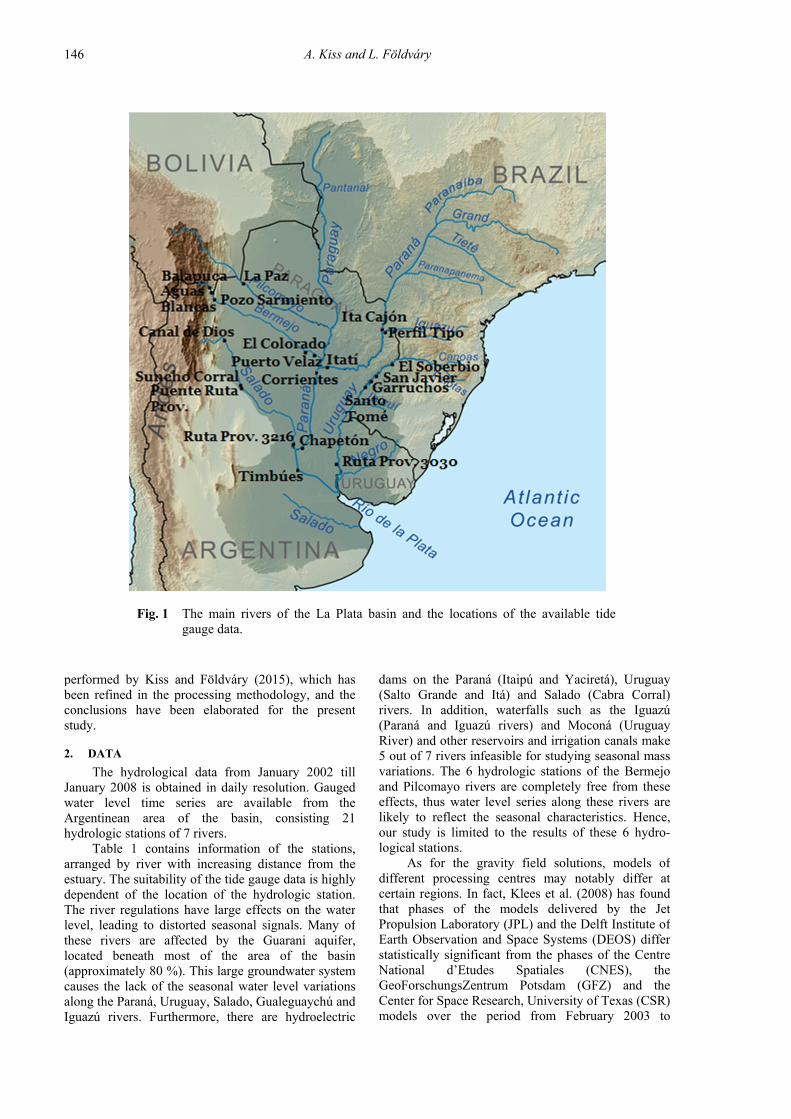
dams on the Paraná (Itaipú and Yaciretá), Uruguay(Salto Grande and Itá) and Salado (Cabra Corral)rivers. In addition, waterfalls such as the Iguazú(Paraná and Iguazú rivers) and Moconá (UruguayRiver) and other reservoirs and irrigation canals make5 out of 7 rivers infeasible for studying seasonal massvariations. The 6 hydrologic stations of the Bermejoand Pilcomayo rivers are completely free from theseeffects, thus water level series along these rivers arelikely to reflect the seasonal characteristics. Hence,our study is limited to the results of these 6 hydro-logical stations.
As for the gravity field solutions, models ofdifferent processing centres may notably differ atcertain regions. In fact, Klees et al. (2008) has foundthat phases of the models delivered by the JetPropulsion Laboratory (JPL) and the Delft Institute ofEarth Observation and Space Systems (DEOS) differstatistically significant from the phases of the CentreNational d’Etudes Spatiales (CNES), theGeoForschungsZentrum Potsdam (GFZ) and theCenter for Space Research, University of Texas (CSR)models over the period from February 2003 to
performed by Kiss and Földváry (2015), which hasbeen refined in the processing methodology, and theconclusions have been elaborated for the presentstudy.
2. DATA
The hydrological data from January 2002 tillJanuary 2008 is obtained in daily resolution. Gaugedwater level time series are available from theArgentinean area of the basin, consisting 21hydrologic stations of 7 rivers.
Table 1 contains information of the stations,arranged by river with increasing distance from theestuary. The suitability of the tide gauge data is highlydependent of the location of the hydrologic station.The river regulations have large effects on the waterlevel, leading to distorted seasonal signals. Many ofthese rivers are affected by the Guarani aquifer,located beneath most of the area of the basin(approximately 80 %). This large groundwater systemcauses the lack of the seasonal water level variationsalong the Paraná, Uruguay, Salado, Gualeguaychú andIguazú rivers. Furthermore, there are hydroelectric
Fig. 1 The main rivers of the La Plata basin and the locations of the available tidegauge data.

COMPARISON OF SEASONAL HYDROLOGIC VARIATIONS IN THE LA PLATA BASIN FROM … .
147
Table 1 Parameters of the hydrological stations.
RIVER/Station ID Distance (km) Latitude Longitude Sampling Interval
BERMEJO
Puerto Velaz 2610 35 -26°39' S -58°37' W daily 2002.01.-2008.12.
El Colorado 2602 124 -26°20'04'' S -59°21'45'' W daily 2002.01.-2008.12.
Pozo Sarmiento 693 783 -23°08'26'' S -64°11'49'' W daily 2002.01.-2008.12.
Aguas Blancas 604 826 -22°43'30'' S -64°21'53'' W daily 2002.01.-2008.12.
Balapuca 605 858 -22°29'33'' S -64°27'49'' W daily 2002.01.-2008.12.
GUALEGUAYCHÚ
Ruta Prov. 3030 76 -32°26'42'' S -58°33'18'' W daily 2002.01.-2008.12.
IGUAZÚ
Perfil Tipo 3440 28 -25°40' S -54°25' W daily 2002.01.-2008.12.
PARANÁ
Timbúes 3316 279 -32°43'11'' S -60°43'34'' W hourly 2003.01.-2007.12.
Chapetón 3005 430 -31°38'48'' S -60°16'44'' W daily 2002.01.-2008.12.
Chapetón 3005 430 -31°38'48'' S -60°16'44'' W monthly 2001.12.-2007.09.
Corrientes 3805 940 -27°27'55'' S -58°50'57'' W daily 2002.01.-2008.12.
Corrientes 3805 940 -27°27'55'' S -58°50'57'' W monthly 2001.12.-2007.08.
Itatí 3862 1007 -27°15'59'' S -58°14'38'' W monthly 2001.12.-2007.08.
Ita Cajón 3452 1542 -25°36' S -54°35' W monthly 2001.12.-2007.08.
PILCOMAYO
La Paz 631 626 -22°22'38'' S -62°31'23'' W daily 2002.01.-2008.12.
SALADO
Ruta Prov. 3216 34 -31°29' S -60°47' W daily 2002.01.-2008.12.
Puente Ruta Prov. 811 563 -28°30'13'' S -62°52'53'' W daily 2004.06.-2008.12.
Suncho Corral 804 655 -27°56'25'' S -63°26'23'' W daily 2004.06.-2008.12.
Canal de Dios 810 951 -25°37'36'' S -63°57'00'' W daily 2002.01.-2008.12.
URUGUAY
Santo Tomé 3860 720 -28°32' S -56°01' W daily 2002.01.-2008.12.
Garruchos 3857 791 -28°10'37'' S -55°38'31'' W daily 2002.01.-2008.12.
San Javier 3449 856 -27°52' S -55°08' W daily 2002.01.-2008.12.
El Soberbio 3442 978 -27°17'55'' S -54°11'37'' W daily 2002.01.-2008.12.
GRACE monthly solutions are available. For practicalreasons 148 models from the period of April 2002 andDecember 2015 have been used instead (seeMethodology section).
3. METHODOLOGY
Based on the RL05 spherical harmoniccoefficients derived from the GRACE measurements,surface mass density changes can be determined bythe methodology of Swenson and Wahr (2002).Surface mass density variations with monthlyresolution are dominated by the mass variations ofocean and hydrology over the test area. The area ofthe basin has been outlined by the method ofLonguevergne et al. (2010) to reduce mass variationeffects of the neighbouring regions and of the ocean,thus the remaining signal may be assumed to begenerated by hydrological processes within the LaPlata basin. Surface mass variations have beencalculated to the locations of the hydrologic stations,and the observed periodic signal has been compared to
February 2006. Similarly, Pereira and Pacino (2012)and Pereira et al. (2012) found slight difference ofCNES, GFZ and CSR models, but all models differnotably from JPL model. Note that Pereira and Pacino(2012) have found the difference to be much less thanit is stated by Klees et al. (2008). According to ourtests (considering CSR, GFZ and JPL solutions only),the difference of these solutions is also not thatrelevant, the estimate of Pereira and Pacino (2012)and Pereira et al. (2012) is more similar to ours.
Generally, in order to avoid the use of anextreme, an ‘average’ model was aimed to be chosenfor the present analysis. During our tests with themethod and parameterization (see Methodologysection), the CSR model have been found being notstriking to any extremes. Based on the tests, theGRACE RL05 Level-2 products of CSR have beenused (RL05). The first GRACE models dated to April2002, thus the overlap period with the time span of 6years of the tide gauge data is from April 2002 toJanuary 2008. During this period 66 models of
A. Kiss and L. Fӧldváry
148
( ) ( )1T Tx A A A l−
= ⋅ ⋅ ⋅ (3),
where A is the design matrix, l is the observationvector, and x is the vector of unknown parameterscontaining a, b, c, d, φc and φd.
As the residuals of the tide gauge water levelseries were found not to follow the normaldistribution, those have been adjusted by a robustmethod:
( ) ( )1T Tx A P A A P l−
= ⋅ ⋅ ⋅ ⋅ ⋅ (4),
where the elements of P are set by an exponentialweight function:
2
1exp
k
p kν
νσ
= − ⋅
(5),
where v is the residual, σv is the standard deviation ofthe residuals, and the values of k1, k2 are determinedempirically (Huber, 1964). In our case these were setto k1 = 0.05 and k2 = 4.4, as suggested by Soha (1986).
Equations (3) and (4) are not linear for theunknowns, thus an iterative solution has been used.Also, the correlation between the seasonal curves andthe corresponding time series (GRACE surface massanomalies or tide gauge water levels) has beendetermined.
4. RESULTS AND DISCUSSION
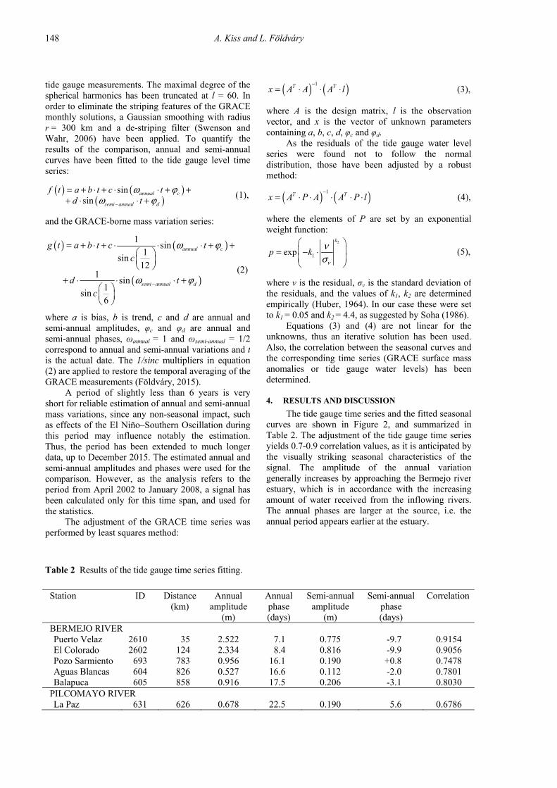
The tide gauge time series and the fitted seasonalcurves are shown in Figure 2, and summarized inTable 2. The adjustment of the tide gauge time seriesyields 0.7-0.9 correlation values, as it is anticipated bythe visually striking seasonal characteristics of thesignal. The amplitude of the annual variationgenerally increases by approaching the Bermejo riverestuary, which is in accordance with the increasingamount of water received from the inflowing rivers.The annual phases are larger at the source, i.e. theannual period appears earlier at the estuary.
tide gauge measurements. The maximal degree of thespherical harmonics has been truncated at l = 60. Inorder to eliminate the striping features of the GRACEmonthly solutions, a Gaussian smoothing with radiusr = 300 km and a de-striping filter (Swenson andWahr, 2006) have been applied. To quantify theresults of the comparison, annual and semi-annualcurves have been fitted to the tide gauge level timeseries:
( ) ( )( )
sinsin
annual c
semi annual d
f t a b t c td t
ω ϕω ϕ−
= + ⋅ + ⋅ ⋅ + ++ ⋅ ⋅ +
(1),
and the GRACE-borne mass variation series:
( ) ( )
( )
1sin
1sin
121
sin1
sin6
annual c
semi annual d
g t a b t c tc
d tc
ω ϕ
ω ϕ−
= + ⋅ + ⋅ ⋅ ⋅ + +
+ ⋅ ⋅ ⋅ +
(2)
where a is bias, b is trend, c and d are annual andsemi-annual amplitudes, φc and φd are annual andsemi-annual phases, ωannual = 1 and ωsemi-annual = 1/2correspond to annual and semi-annual variations and tis the actual date. The 1/sinc multipliers in equation(2) are applied to restore the temporal averaging of theGRACE measurements (Földváry, 2015).
A period of slightly less than 6 years is veryshort for reliable estimation of annual and semi-annualmass variations, since any non-seasonal impact, suchas effects of the El Niño–Southern Oscillation duringthis period may influence notably the estimation.Thus, the period has been extended to much longerdata, up to December 2015. The estimated annual andsemi-annual amplitudes and phases were used for thecomparison. However, as the analysis refers to theperiod from April 2002 to January 2008, a signal hasbeen calculated only for this time span, and used forthe statistics.
The adjustment of the GRACE time series wasperformed by least squares method:
Table 2 Results of the tide gauge time series fitting.
Station ID Distance Annual Annual Semi-annual Semi-annual Correlation (km) amplitude
(m) phase (days)
amplitude (m)
phase (days)
BERMEJO RIVER Puerto Velaz 2610 35 2.522 7.1 0.775 -9.7 0.9154 El Colorado 2602 124 2.334 8.4 0.816 -9.9 0.9056 Pozo Sarmiento 693 783 0.956 16.1 0.190 +0.8 0.7478 Aguas Blancas 604 826 0.527 16.6 0.112 -2.0 0.7801 Balapuca 605 858 0.916 17.5 0.206 -3.1 0.8030
PILCOMAYO RIVER La Paz 631 626 0.678 22.5 0.190 5.6 0.6786
COMPARISON OF SEASONAL HYDROLOGIC VARIATIONS IN THE LA PLATA BASIN FROM … .
149
Fig. 2 Fitting of seasonal variation curves on tide gauge data of Puerto Velaz, El Colorado,Pozo Sarmiento, Aguas Blancas, Balapuca and La Paz stations.
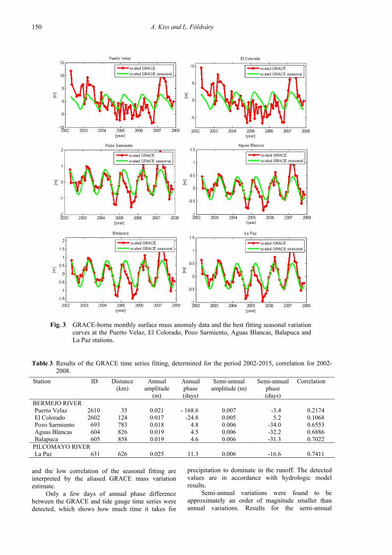
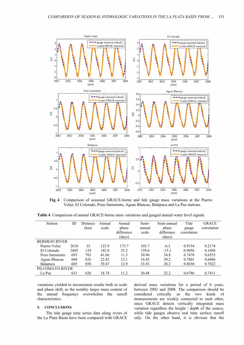
Comparing the tide gauge and GRACE results,c.f. Figure 4, it is conspicuous that the tide gaugeannual amplitudes are the multiples of the GRACEamplitudes. This is a consequence of the essentialdifference of water mass variation and gauged waterlevel. In Figure 4, scaling factors have been applied tomake the curves comparable, c.f. 4th column ofTable 4. Generally, the annual scale was found toincrease by approaching to the estuary. Earlier studieshave also been applied a scale factor when comparedGRACE-borne mass variation with gauged water levelmeasurements. Andersen et al. (2008) used a valuearound 10 for the scaling at the Chandpur River. Vazde Almeida et al. (2012) have been studied theAmazon basin and calculated with scale factorsbetween 10 and 20. The observed 18-42 annual scalefactors in this study are slightly higher than theseresults, with the exception of station Puerto Valez andEl Colorado, close to the estuary of the BermejoRiver, in which cases the large (>100) scale factors
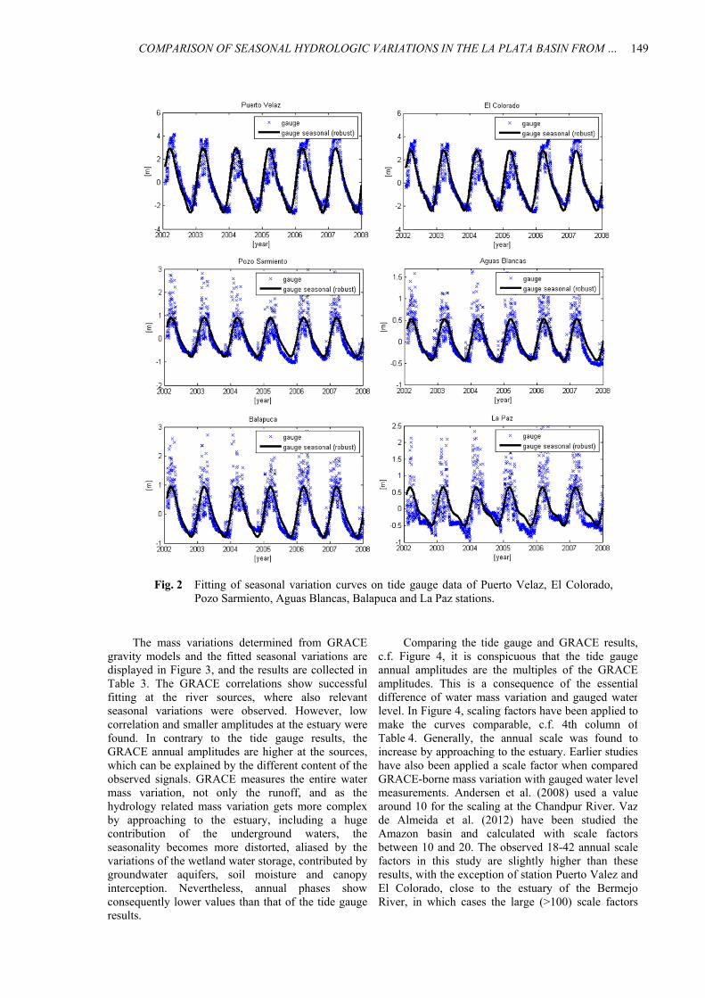
The mass variations determined from GRACEgravity models and the fitted seasonal variations aredisplayed in Figure 3, and the results are collected inTable 3. The GRACE correlations show successfulfitting at the river sources, where also relevantseasonal variations were observed. However, lowcorrelation and smaller amplitudes at the estuary werefound. In contrary to the tide gauge results, theGRACE annual amplitudes are higher at the sources,which can be explained by the different content of theobserved signals. GRACE measures the entire watermass variation, not only the runoff, and as thehydrology related mass variation gets more complexby approaching to the estuary, including a hugecontribution of the underground waters, theseasonality becomes more distorted, aliased by thevariations of the wetland water storage, contributed bygroundwater aquifers, soil moisture and canopyinterception. Nevertheless, annual phases showconsequently lower values than that of the tide gaugeresults.
A. Kiss and L. Fӧldváry
150
Fig. 3 GRACE-borne monthly surface mass anomaly data and the best fitting seasonal variationcurves at the Puerto Velaz, El Colorado, Pozo Sarmiento, Aguas Blancas, Balapuca andLa Paz stations.
Table 3 Results of the GRACE time series fitting, determined for the period 2002-2015, correlation for 2002-2008.
Station ID Distance Annual Annual Semi-annual Semi-annual Correlation (km) amplitude
(m) phase (days)
amplitude (m) phase (days)
BERMEJO RIVER Puerto Velaz 2610 35 0.021 - 168.6 0.007 -3.4 0.2174 El Colorado 2602 124 0.017 -24.8 0.005 5.2 0.1068 Pozo Sarmiento 693 783 0.018 4.8 0.006 -34.0 0.6553 Aguas Blancas 604 826 0.019 4.5 0.006 -32.2 0.6886 Balapuca 605 858 0.019 4.6 0.006 -31.3 0.7022
PILCOMAYO RIVER La Paz 631 626 0.025 11.3 0.006 -16.6 0.7411
precipitation to dominate in the runoff. The detectedvalues are in accordance with hydrologic modelresults.
Semi-annual variations were found to beapproximately an order of magnitude smaller thanannual variations. Results for the semi-annual
and the low correlation of the seasonal fitting areinterpreted by the aliased GRACE mass variationestimate.
Only a few days of annual phase differencebetween the GRACE and tide gauge time series weredetected, which shows how much time it takes for
COMPARISON OF SEASONAL HYDROLOGIC VARIATIONS IN THE LA PLATA BASIN FROM … .
151
Fig. 4 Comparison of seasonal GRACE-borne and tide gauge mass variations at the PuertoVelaz, El Colorado, Pozo Sarmiento, Aguas Blancas, Balapuca and La Paz stations.
Table 4 Comparison of annual GRACE-borne mass variations and gauged annual water level signals.
Station ID
Distance (km)
Annual scale
Annual phase
difference (days)
Semi-annual scale
Semi-annual phase
difference (days)
Tide gauge
correlation
GRACE correlation
BERMEJO RIVER Puerto Velaz 2610 35 123.9 175.7 105.7 -6.3 0.9154 0.2174 El Colorado 2602 124 142.8 33.2 159.6 -15.1 0.9056 0.1068 Pozo Sarmiento 693 783 41.66 11.3 30.96 34.8 0.7478 0.6553 Aguas Blancas 604 826 22.82 12.1 18.45 30.2 0.7801 0.6886 Balapuca 605 858 39.47 12.9 33.83 28.2 0.8030 0.7022
PILCOMAYO RIVER La Paz 631 626 18.74 11.2 30.48 22.2 0.6786 0.7411
derived mass variations for a period of 6 years,between 2002 and 2008. The comparison should beconsidered critically as the two kinds ofmeasurements are weakly connected to each other,since GRACE detects vertically integrated massvariation regardless the height / depth of the source,while tide gauges observe real time surface runoffonly. On the other hand, it is obvious that the
variations yielded to inconsistent results both in scaleand phase shift, as the notably larger mass content ofthe annual frequency overwhelms the runoffcharacteristics.
5. CONCLUSIONS
The tide gauge time series data along rivers ofthe La Plata Basin have been compared with GRACE
A. Kiss and L. Fӧldváry
152
and Gruber, Th.: 2005, Mass transport and massdistribution in the Earth system. Contributions of thenew generation of satellite gravity and altimetrymissions to the Geosciences. Proposal for a Germanpriority research program 2nd ed., GOCE-ProjektbüroTU München, GeoForschungsZentrum Potsdam,München, Potsdam.
Kiss, A. and Földváry, L.: 2015, Annual hydrologicvariations from GRACE gravity models. GeomatikaiKözlemények, XVIII/2, 43–52, (in Hungarian).
Klees, R., Liu, X., Wittwer, T., Gunter B.C., Revtova, E.A.,Tenzer, R., Ditmar, P., Winsemius, H.C. and Savenije,H.H.G.: 2008, A comparison of global and regionalGRACE models for land hydrology. Surv Geophys,29, 335–359. DOI: 10.1007/s10712-008-9049-8
Longuevergne, L., Scanlon, B.R. and Wilson, C.R.: 2010,GRACE hydrological estimates for small basins:Evaluating processing approaches on the High PlainsAquifer, USA. Water Resour. Res., 46, W11517. DOI: 10.1029/2009WR008564
Pereira, A. and Pacino, M.C.: 2012, Annual and seasonalwater storage changes detected from GRACE data inthe La Plata Basin. Physics of the Earth and PlanetaryInteriors, 212–213, 88–99. DOI: 10.1016/j.pepi.2012.09.005
Pereira, A., Miranda, S., Pacino, M.C. and Forsberg, R.:2012, Water storage changes from GRACE data in theLa Plata basin. In Proceedings of IAG Symposium inBuenos Aires, eds. Kenyon, S.C., Pacino, M.C. andMarti, U.J., IAG Symposia Series, 131, 147–152,Springer Heidelberg Dordrecht London New York.
Soha, G.: 1986, A method of robust adjustment withcorrections dependent weighting. Geodézia ésKartográfia, 4, 267–271, (in Hungarian).
Swenson, S. and Wahr, J.: 2002, Methods for inferringregional surface-mass anomalies from GRACEmeasurements of time-variable gravity. J. Geophys.Res., 107(B9), 2193. DOI: 10.1029/2001JB000576
Swenson, S. and Wahr, J.: 2006, Post-processing removal ofcorrelated errors in GRACE data. GeophysicalResearch Letters, 33, L08402. DOI: 10.1029/2005GL025285
Vaz de Almeida Filho, F.G., Calmant, S., Seyler, F.,Ramillien, G., Blitzkow, D., Matos, A.C.C. and Silva,S.J.: 2012, Time-variations of equivalent water heightsfrom Grace Mission and in-situ river stages in theAmazon basin. Acta Amazonica (Impresso), 42, 125–134.
Wahr, J. and Schubert, G. (Ed.): 2007, Time variable gravityfrom satellites. Treatise on Geophysics, 213–218,Oxford, Elsevier Ltd.
Zenner, L., Gruber, Th., Beutler, G., Jäggi, A., Flechtner, F.,Schmidt, T., Wickert, J., Fagiolini, E., Schwarz, G.and Trautmann, T.: 2012, Using atmosphericuncertainties for GRACE de-aliasing: first results, In:Proceedings of IAG Symposium in Buenos Aires, eds.Kenyon, S.C., Pacino, M.C. and Marti, U.J. IAGSymposia Series, 131, 147–152, Springer HeidelbergDordrecht London New York.
phenomena are strictly connected to each other:precipitation must appear in the runoff sooner or later.The time delay between precipitation and runoff iscaused by different forms of water storage, such asgroundwater aquifers, soil moisture or canopyinterception. The time delay due to water storage isestimated in this study as the difference in theseasonal cycle of the precipitation and water storage(GRACE) and runoff (tide gauge).
The investigation has lead to the followingresults. 1) It was found that rivers under heavy water control,i.e. dams, and the Guarani aquifer alias so much theperiodicity of the nearby water mass variations that norelevant annual or semi-annual period can be seenneither on GRACE nor on tide gauge water level data.Among the 7 rivers only 2 could be used for furtheranalysis. 2) Close to the estuary of a river the periods of thedifferent influents and subsurface sources are so muchmixed that no relevant annual and semi-annual periodcould be determined. Along the investigated6 hydrologic stations 2 (at estuary distance of 35 and124 km) have been excluded, the remaining 4 stationshas been located from the estuary at 626, 783, 826 and858 km. 3) Based on these 4 stations, time delay betweenprecipitation and runoff has been found to be 11-13 days on annual period. 4) Semi-annual variations are an order of magnitudesmaller than annual variations, and are overwhelmedby the annual variations. Semi-annual variationsshowed a time delay of 22-35 days, but these areconsidered to be inconsistent due to its inconsistencyboth in scale and phase shift. ACKNOWLEDGEMENT
The authors are grateful for Prof. Maria CristinaPacino and Dr. Ayelen Pereira for providing the tidegauge water level data in the La Plata basin.
REFERENCES
Andersen, O., Berry, P., Freeman, J., Lemoine, F.G.,Luthcke, S., Jakobsen, K. and Butts, M.: 2008,Satellite altimetry and GRACE gravimetry for studiesof annual water storage variations in Bangladesh. Terr.Atmos. Ocean Sci., 19, 47–52. DOI:10.3319/TAO.2008.19.1-2.47(SA)
Földváry, L.: 2015, Desmoothing of averaged periodicalsignals for geodetic applications. Geophysical JournalInternational, 201 (3), 1235–1250. DOI 10.1093/gji/ggv092
Huber, P.J.: 1964, Robust estimation of a locationparameter. Ann. Mathem. Statist., Princetown 35.
Ilk, K.H., Flury, J., Rummel, R., Schwintzer, P. Bosch, W.,Haas, C., Schröter, J., Stammer, D., Zahel, W., Miller,H., Dietrich, R., Huybrechts, P., Schmeling, H., Wolf,D., Götze, H.J., Riegger, J., Bardossy, A., Günter, A.