Embed Size (px)
Citation preview
Author's personal copy
Comparison of the X-TRACK altimetry estimated currents withmoored ADCP and HF radar observations on the West Florida Shelf
Yonggang Liu a,⇑, Robert H. Weisberg a, Stefano Vignudelli b, Laurent Roblou c,Clifford R. Merz a
a College of Marine Science, University of South Florida, 140 7th Avenue South, St. Petersburg, FL 33701, USAb Consiglio Nazionale delle Ricerche, Area Ricerca CNR, Via Moruzzi 1, 56127 Pisa, Italy
c Universite de Toulouse, CNRS/CNES/IRD/UPS, Laboratoire d‘Etudes en Geophysique et Oceanographie Spatiales (LEGOS), 14 av Edouard Belin,
F-31400 Toulouse, France
Available online 19 September 2011
Abstract
The performance of coastal altimetry over a wide continental shelf is assessed using multiple-year ocean current observations bymoored Acoustic Doppler Current Profilers (ADCP) and high-frequency (HF) radar on the West Florida Shelf. Across-track, surfacegeostrophic velocity anomalies, derived from the X-TRACK along-track sea level anomalies are compared with the near surface currentvector components from moored ADCP observations at mid shelf. The altimeter-derived velocity anomalies are also directly comparedwith the HF radar surface current vector radial components that are aligned perpendicular to the satellite track. Preliminary results indi-cate the potential usefulness of the along-track altimetry data in contributing to descriptions of the surface circulation on the West Flor-ida Shelf and the challenges of such applications. On subtidal time scales, the root-mean-square difference (rmsd) between the estimatedand the observed near surface velocity component anomalies is 8–11 cm/s, which is about the same magnitude as the standard deviationsof the velocity components themselves. Adding a wind-driven Ekman velocity component generally helps to reduce the rmsd values.� 2011 COSPAR. Published by Elsevier Ltd. All rights reserved.
Keywords: Coastal altimetry; X-TRACK; TOPEX/Poseidon; Jason-1; Moored ADCP; HF radar
1. Introduction
Satellite altimeters play an important role in oceanobservations by providing repeated Sea Surface Height(SSH) information for the world’s oceans (e.g., Fu andChelton, 1984; Benveniste, 2011). Altimeter-derived SeaLevel Anomaly (SLA) data are often used to infer surfacegeostrophic current anomalies, which are usually goodapproximations of surface current anomalies in deep oceanregions. Thus, altimetry-derived surface velocity productsare used to study large-scale circulation in the world’soceans (e.g., Le Traon and Morrow, 2001; Lagerloef
et al., 2003; Johnson et al., 2007) and its semi-enclosed seas(e.g., Cipollini et al., 2008; Liu et al., 2008; Alvera-Azcarateet al., 2009). However, such altimetry applications aremainly limited to such regions. In addition to commonproblems with altimetry data (e.g., Schlax and Chelton,1994; Mitchum, 2000; Gaspar et al., 2001; Le Provost,2001; Chambers et al., 2003; Mitchell et al., 2004; Mitchumet al., 2004; Ponte et al., 2007), there are intrinsic limita-tions to the altimetry data in shallow seas and near coast-lines (e.g., Anzenhofer et al., 1999; Andersen, 1999; Denget al., 2002; Vignudelli et al., 2005; Roblou et al., 2011).Prior and existing satellite altimetry missions were notdesigned for applications in coastal oceans where the dom-inant dynamical processes have shorter temporal and spa-tial scales than those of the open ocean (Chelton, 2001).
However, in recent years, reprocessing of the along-track altimetry data has been pursued for the purpose ofimproving the data quality within the coastal oceans
0273-1177/$36.00 � 2011 COSPAR. Published by Elsevier Ltd. All rights reserved.
doi:10.1016/j.asr.2011.09.012
⇑ Corresponding author. Tel.: +1 727 553 3508.E-mail addresses: [email protected], [email protected] (Y. Liu),
[email protected] (R.H. Weisberg), [email protected](S. Vignudelli), [email protected] (L. Roblou), [email protected] (C.R. Merz).
www.elsevier.com/locate/asr
Available online at www.sciencedirect.com
Advances in Space Research 50 (2012) 1085–1098

Author's personal copy
(e.g., Vignudelli et al., 2005; Roblou et al., 2007; Madsenet al., 2007; Brown, 2010). As a result the useful altimetrydata domain now extends further toward the coast. Forexample, with specialized corrections and processing strat-egies, Vignudelli et al. (2005) processed a SLA data set in a30-km narrow path between Corsica and Capraia Islands,within the Corsica Channel. In the same area, a multi-mis-sion data set was extended to a mean distance of 32 kmfrom the coast (Bouffard et al., 2008). Despite innovativeefforts from Dussurget et al. (2011), it is still challengingto get two-dimensional gridded SSH maps for coastalapplications. The repeated along-track altimeter data isan independent source of oceanographic data that can pro-vide useful information on coastal ocean dynamics. Forexample, the surface geostrophic velocity estimated fromthe along-track altimetry data may be used to study coastalocean circulation on continental shelves, especially whenthe satellite tracks are in across-shelf direction (e.g., Han2004b, 2006; Durand et al., 2008, 2009; Le Henaff et al.,2011), and time series of surface geostrophic velocity vec-tors may be obtained at the crossover points of two inter-secting satellite tracks (e.g., Bouffard et al., 2008).
Advances of coastal altimetry techniques and applica-tions are summarized in a recent book (Vignudelli et al.,2011). Included is a review of coastal altimetry applicationsin North American coastal oceans by Emery et al. (2011).Applications of altimeter-derived currents were mostly onseasonal and longer time scales (e.g., Strub et al., 1997;Foreman et al., 1998; Strub and James, 2000; Li andClarke, 2005; Venegas et al., 2008) and focused on currentson continental slopes (e.g., Kelly and Gille, 1990; Kellyet al., 1998; Dong and Kelly, 2003; Han, 2004a, 2007) oreven more offshore (e.g., Leben and Born, 1993; Sturgesand Leben, 2000; Leben, 2005). Recent coastal altimetryapplications show that altimeter-derived currents may beextended to the coast by combining with tide gauges(e.g., Saraceno et al., 2008). However, such efforts aremainly for narrow continental shelves where the deepocean influence is close to the tide gauges, allowing theSSH on the shelf to be linearly interpolated between theopen ocean and coastal tide gauges.
In contrast, applications of altimeter-derived velocityare rarely seen over wide and shallow continental shelves(e.g., Han et al., 1993, 2002; Volkov et al., 2007). However,satellite altimetry showed some promise on the wide WestFlorida Shelf (WFS) (e.g., Liu and Weisberg, 2007). Basedon dominant inner-shelf momentum balance, Liu andWeisberg (2007) proposed a method for estimating abso-lute SSH near the coast by integrating sea level inferencesfrom in situ coastal ocean observations (time series ofvelocity, hydrography, bottom pressure, coastal tide gaugeand winds) along a WFS shore normal transect. Comparedwith the satellite SLA from the merged AVISO product(e.g., Ducet et al., 2000; Le Traon et al., 2003; Pascualet al., 2006), the estimated SSH time series at the 50 m iso-bath site showed encouraging results (Liu and Weisberg,2007). Recently, Carlson and Clarke (2009) estimated the
monthly mean along-shelf component of the geostrophicvelocity on the outer WFS, but without testing againstin situ current observations.
Evaluation of altimeter-derived surface velocity wasseen in many deep ocean studies (e.g., Menkes et al.,1995; Stammer, 1997; Strub et al., 1997; Dong and Kelly,2003). Strub et al. (1997) evaluated TOPEX altimeter-derived velocities with moored Acoustic Doppler CurrentProfilers (ADCP) (at 4800 m water sites) velocities atdepths below the Ekman layer for the California CurrentSystem. Dong and Kelly (2003) compared the altimeter-derived geostrophic currents with moored current meterrecords at 1000–3000 m water sites in the Middle AtlanticBight. Recently, such validations were found in coastaloceans. For example, Powell et al. (2006) comparedTOPEX/Poseidon (T/P) and Jason-1 (J1) altimeter-derivedvelocity time series with moored ADCP currents on theshelf in the northwestern Gulf of Mexico during a six-month period. Saraceno et al. (2008) evaluated a coastalSSH product of combined AVISO and tide gauge data setsby comparing the SSH-derived coastal velocity with bothmoored ADCP and HF radar currents on the narrow Ore-gon-California shelf. Vignudelli et al. (2005) and Bouffardet al. (2008) using respectively a single mission and amulti-mission configuration also evaluated altimeter-derived velocity data with moored currents over a coastalzone of the northwestern Mediterranean where the coast-line and bathymetry are complex.
As a follow-on study of Liu and Weisberg (2007), thispaper assesses the usefulness of satellite altimetry on a widecontinental shelf with relatively simple bathymetry andcoastline shape. Altimeter-derived geostrophic velocityanomaly time series are compared with the multiple-yearvelocity component records from moored ADCPs andHF radars on the WFS. The purpose is to determine towhat extent the shelf currents may be approximated byaltimeter-derived currents on subtidal time scales in thevicinity of the 50 m isobath or approximately near mid-shelf. This is one step toward future applications of coastalaltimetry; for instance, to provide surface geostrophic cur-rent maps or to examine Loop Current and Loop Currenteddy interactions with the shelf.
Data and data processing are described in Section 2. Themethodology for estimating surface geostrophic velocitycomponents is provided in Section 3. Velocity componentcomparisons, based on moored ADCP and HF radar data,are given in Sections 4 and 5, respectively. Section 6 pro-vides a summary and discussion.
2. Data
2.1. X-TRACK SLA altimetry product
The altimetry data used in this analysis is based onGeophysical Data Records (GDR) provided by AVISO(AVISO 1996, 2008) for both the T/P and J1 missions. Acoastal altimetry SLA product is then generated from the
1086 Y. Liu et al. / Advances in Space Research 50 (2012) 1085–1098

Author's personal copy
X-TRACK post-processing tool (Roblou et al., 2007, 2011)developed at Centre de Topographie des Oceans et del’Hydrosphere (CTOH). In particular, the CTOH/X-TRACK SLA data are subjected to the followingcorrections:
SLA ¼ SLA0�DAC� TIDES; ð1Þ
where SLA0 is the X-TRACK SLA without applying thegeophysical corrections, DAC includes the atmosphericloading effects, i.e., MOG2D-G model (Carrere and Lyard,2003) sea level, and TIDES includes solid earth (Cartwrightand Taylor, 1971), loading and ocean tides GOT4.7 (Ray,1999; 2008). More details about the X-TRACK post-pro-cessing can be seen in Roblou et al. (2007, 2011). Recentapplications of X-TRACK altimetry data were seen inthe Mediterranean Sea (Birol et al., 2010; Bouffard et al.,2011), along the Spanish coasts (Le Henaff et al., 2011;Dussurget et al., 2011; Herbert et al., 2011), and the Solo-mon Sea (Melet et al., 2010).
The satellite ground track 091 of T/P and J1 missionscrosses the northern part of the WFS (Fig. 1a), and thedata are used to compare with the moored ADCP datain this paper. The other track (167) passes by a more com-plicated topography area (parallel to and then crossing theisobaths) on the southern WFS, and it is not used in this
analysis. Two satellite ground tracks (102 and 167) ofT/P interlaced orbit passing over the central WFS are usedto compare with the HF radar data (Fig. 1b). The 1 Hzalong-track SLA data contain high-frequency gravitywaves (e.g., Ray and Mitchum, 1996; Zhao et al., 2010)that are not of our interest at present. A 30 km ‘box-car”low-pass filter is applied to each cycle of the track. Thishopefully removes the high-wavenumber variations (thevariance is reduced by about 5%). The distance betweentwo adjacent points along the satellite track is about 6 km.
2.2. In situ observations on the West Florida Shelf
Velocity measurements by moored ADCPs began on theWFS in 1993, first at a single location (PM1) on the 47 misobath (Fig. 1a), and then at multiple locations acrossthe shelf (e.g., Weisberg et al., 1996, 2000, 2005, 2009a,b;Meyers et al., 2001; Liu and Weisberg, 2005a,b, 2007).Unfortunately, no moorings are located on any of the satel-lite ground tracks. Also, many of the moorings are locatedlandward of the 30 m isobath, where the altimeter data areproblematic. Thus, data from the moorings deployedaround the 50 m isobath (PM1, C12 and C13) are chosenfor a preliminary assessment of the altimeter-derived cur-rents. Note that these locations are at least 90 km away
Fig. 1. Altimetry satellite tracks, mooring locations, and HF radar spatial coverage on the West Florida Shelf. (a) J1 and T/P satellite ground tracks (bluelines) and ADCP mooring locations (PM1, C12 and C13). The long-term mean depth-averaged currents (Weisberg et al., 2009b) are shown as vectors.(b) T/P Interleaved satellite ground tracks and HF radar coverage map (red arcs). NOAA/NDBC Buoy 42036 is shown on both maps. Also shown arebathymetry contours (units in m). (For interpretation of the references to colour in this figure legend, the reader is referred to the web version of thisarticle.)
Y. Liu et al. / Advances in Space Research 50 (2012) 1085–1098 1087
Author's personal copy
from the coastline. With downward-looking ADCPs, cur-rents measured across most of the water column (excludingroughly 4 m from either the surface or the bottom) arearchived hourly. Quality control and editing proceduresare provided by Liu and Weisberg (2005a,b) and Mayeret al. (2007).
Complementing the moored ADCPs, CODAR Sea-Sonde, long-range HF radars have been deployed on theWFS since September 2003 (Liu et al., 2010). These HFradars operate at a nominal frequency of 5 MHz, withthe intended purpose of observing surface currents out toa range of about 200 km offshore. However, due to thelow energy (waves and currents) nature of the WFS, theHF radar data returns are gappy in both space and time(Liu et al., 2010). When acquired, the velocity componentsby HF radar compare well with those by moored ADCPs.Radial data coverage fluctuates with time on different timescales, and varies from station to station (Liu et al., 2010).Among the three radar sites, the Venice site (27� 04.6550 N,82� 27.0960 W) has the best data return, and thus its dataare used in this analysis. Its radar spatial coverage/foot-print is shown in Fig. 1b. With such 5-MHz radar, theradial velocity estimates are at an effective depth of 2 m,with nominal range and bearing resolutions of 5.8 kmand 5�, respectively. Hourly radial current maps arearchived and processed using the CODAR SeaSonde soft-ware suite after directional calibration using measuredantenna patterns as in Kohut and Glenn (2003). A commu-nity toolbox “HFR_Progs” is used to remove the outliersand to interpolate the radial data onto uniform radialgrids. Detailed information about the HF radar data pro-cessing and the availability of the data during 2003–2008are provided in Liu et al. (2010).
2.3. Wind data and Ekman component computation
Hourly wind data were obtained from the NationalData Buoy Center (NDBC) buoy 42036 (online at http://www.ndbc.noaa.gov/station_page.php?station=42036) atthe 55-m isobath (Fig. 1). The anemometer height for thebuoy is 4 m. The hourly winds were adjusted to a standard10-m level prior to further analysis. The wind stress is cal-culated using a variable drag coefficient depending on themagnitude of the wind speed (Blanton et al., 1989). Low-pass filtering with a 36 h cut-off period provides wind stresstime series for estimating the surface Ekman velocity com-ponent based on the deep water Ekman equations (Ekman,1905; Lenn and Chereskin, 2009) with a constant eddy vis-cosity (K = 0.02 m2/s).
3. Estimation of geostrophic velocity from along-track
altimeter data
Internally generated white noise in altimetry data canaffect the accuracy of the slope estimate from along-trackSLA. It can dominate the errors in estimating mesoscalecurrents in coastal oceans because a simple finite-difference
of the along-track SLA acts as a high-pass filter (Powelland Leben, 2004). This effect may be mitigated by usinglonger difference operator lengths, e.g., differencing overlarger point-to-point intervals, which is equivalent to a run-ning average of the geostrophic velocity component esti-mates along the satellite ground tracks (e.g., Strub et al.,1997). Powell and Leben (2004) provide a compact, opti-mal difference operator to minimize the white noise ofthe SLA measurements when computing SSH slope (andhence geostrophic velocity) by weighted smoothing along-track SLA:
DpqNt ¼
Xq
n¼�P–0
cnhiþn � hi
nDt
� �; ð2Þ
where hi is the SLA at the current (i) point along the track,and Dt is the sampling interval in seconds, p and q are thenumber of points before and after the current point,N = p + q, and cn are the weighting coefficients that satisfy
Xq
n¼�P–0
cn ¼ 1: ð3Þ
[We note a minor typo in Eq. (3) of Powell and Leben(2004), where the subscript i + 1 should be i + n as ap-peared in Eq. (2) of this paper]. The weights may be deter-mined by minimizing the noise in calculating the slope ofthe along-track SSH. This optimal filter is ideal for coastalocean studies where the baroclinic Rossby radius of defor-mation is small. Use of this filter may be found in Lebenand Powell (2003), Powell et al. (2006), Deng et al. (2008)and Godin et al. (2009).
The optimal filter of Powell and Leben (2004) is usedhere to smooth the along-track sea level slope Dh, whichis further used to compute across-track geostrophic veloc-ity anomaly:
vgeo ¼gf
DhDx
; ð4Þ
where g is acceleration of gravity, f is Coriolis parameter,and Dx is the along-track distance between two adjacentpoints. A 12-point filter (p = 5, q = 6) is used here, and thelength of 11 consecutive points along the satellite groundtrack is about 60 km, which is about twice the baroclinicRossby radius of deformation (estimated, for instance, byHe and Weisberg (2003)). The selection of the filter size iswithin the suggested range for this area, according toFig. 3 of Powell and Leben (2004). It is expected that this fil-ter size results in a slope noise standard deviation of 4–6 cm/sin the geostrophic velocity (Powell and Leben, 2004).
4. Comparison with moored ADCP observations
4.1. Mooring PM1
Velocity data at mooring PM1 is available from October1993 to January 1995. The corresponding satellite altimeter
1088 Y. Liu et al. / Advances in Space Research 50 (2012) 1085–1098

Author's personal copy
data is from T/P mission, which spans November 1992 toAugust 2002. The altimeter-derived surface geostrophicvelocity component anomalies are compared to ADCPnear-surface velocity component anomalies in two direc-tions: (1) across-track direction (i.e., perpendicular to satel-lite ground track 091, Points N and PM1), and (2) along-shelf direction (Points P and PM1). The distance betweenpoint N and mooring PM1 is about 44 km (Fig. 1a). Toget an estimate of the along-shelf velocity component atPoint P, the across-track geostrophic velocity componentat Point P is divided by cos(h), where h is the angle betweenacross-track direction and the along-shelf direction. Essen-tially, it is an exemplification of across-track velocity com-ponent at that point. This is consistent with the fact thatthe subtidal principal axis currents are in the along-shelfdirection (Liu and Weisberg, 2005b). The near surfacevelocity vectors (with the top bin at 4 m below surface)are 36-h low-pass filtered and then rotated to get theacross-track or along-shelf velocity component. A record-long mean value is further removed to get velocity anomalyvadcp. The altimeter-derived surface geostrophic velocitycomponent anomalies (vgeo) are averaged among threeadjacent points to further reduce the effects of small-scalefeatures.
To examine whether a wind-driven surface Ekmanvelocity contribution plays a role, the subsurface (4 m)Ekman velocity is rotated to the across-track or along-shelf
directions, respectively, and the mean value is removed forcomparison (vEkm). Time series of across-track velocitycomponent anomalies and their differences are shown inFig. 2. The standard deviations of the moored ADCP vadcp,altimeter-derived vgeo and geostrophic plus Ekman velocitycomponents (vgeo + vEkm), at the altimeter data timestamps, are about the same (7.0, 8.1 and 8.8 cm/s, respec-tively). The root-mean-square difference (rmsd) betweenthe altimeter-derived and moored velocity anomalies is8.6 cm/s, about the same magnitude as the standard devia-tions of the velocity anomalies (Table 1). When the Ekmanvelocity component is added to altimeter-derived velocityanomaly, we see a slight reduction in the rmsd value. Theresidual time series is shown in Fig. 2b. In a perfect com-parison, the residuals would all be zero. We can see reduc-tions of the residuals at some times (e.g., the two points inOctober 1993), however, there are still large variations ofthe residuals. The standard deviation of the residuals is8.0 cm/s (7.9 cm/s with wind effect considered), which isabout the same magnitude as the standard deviations ofthe velocities themselves. Results from Vignudelli et al.(2005), Saraceno et al. (2008) and Le Henaff et al. (2011)also highlight an rms-difference comparable to the tempo-ral velocity anomaly variability itself.
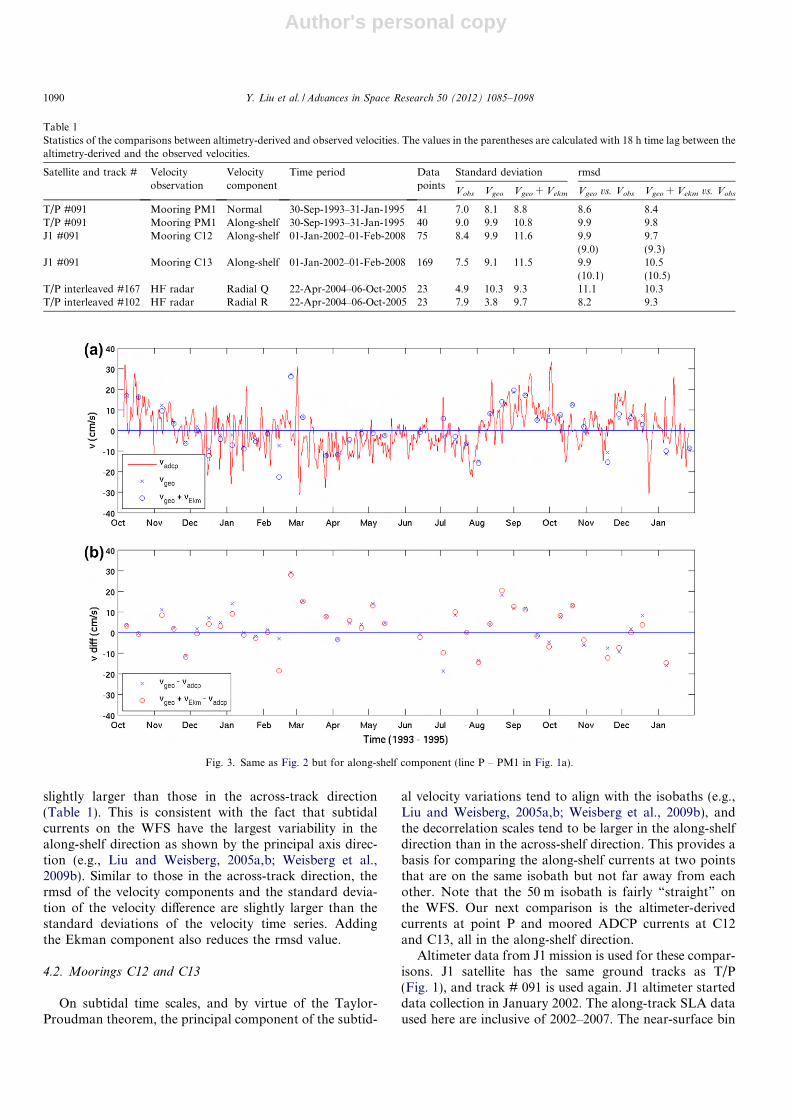
In the along-shelf direction (Fig. 3), the standard devia-tions of the velocity components, their rmsd values, and thestandard deviations of the velocity differences are all
Fig. 2. Comparison of velocity components perpendicular to the T/P satellite track 091 (Points N and PM1 in Fig. 1a): surface geostrophic velocitycalculated from along-track altimetry (+surface Ekman velocity) versus ADCP near-surface (4 m) velocity anomalies (a) and their differences (b). Both theADCP and wind time series are 36 h lowpass filtered.
Y. Liu et al. / Advances in Space Research 50 (2012) 1085–1098 1089
Author's personal copy
slightly larger than those in the across-track direction(Table 1). This is consistent with the fact that subtidalcurrents on the WFS have the largest variability in thealong-shelf direction as shown by the principal axis direc-tion (e.g., Liu and Weisberg, 2005a,b; Weisberg et al.,2009b). Similar to those in the across-track direction, thermsd of the velocity components and the standard devia-tion of the velocity difference are slightly larger than thestandard deviations of the velocity time series. Addingthe Ekman component also reduces the rmsd value.
4.2. Moorings C12 and C13
On subtidal time scales, and by virtue of the Taylor-Proudman theorem, the principal component of the subtid-
al velocity variations tend to align with the isobaths (e.g.,Liu and Weisberg, 2005a,b; Weisberg et al., 2009b), andthe decorrelation scales tend to be larger in the along-shelfdirection than in the across-shelf direction. This provides abasis for comparing the along-shelf currents at two pointsthat are on the same isobath but not far away from eachother. Note that the 50 m isobath is fairly “straight” onthe WFS. Our next comparison is the altimeter-derivedcurrents at point P and moored ADCP currents at C12and C13, all in the along-shelf direction.
Altimeter data from J1 mission is used for these compar-isons. J1 satellite has the same ground tracks as T/P(Fig. 1), and track # 091 is used again. J1 altimeter starteddata collection in January 2002. The along-track SLA dataused here are inclusive of 2002–2007. The near-surface bin
Table 1Statistics of the comparisons between altimetry-derived and observed velocities. The values in the parentheses are calculated with 18 h time lag between thealtimetry-derived and the observed velocities.
Satellite and track # Velocityobservation
Velocitycomponent
Time period Datapoints
Standard deviation rmsd
Vobs Vgeo Vgeo + Vekm Vgeo vs. Vobs Vgeo + Vekm vs. Vobs
T/P #091 Mooring PM1 Normal 30-Sep-1993–31-Jan-1995 41 7.0 8.1 8.8 8.6 8.4T/P #091 Mooring PM1 Along-shelf 30-Sep-1993–31-Jan-1995 40 9.0 9.9 10.8 9.9 9.8J1 #091 Mooring C12 Along-shelf 01-Jan-2002–01-Feb-2008 75 8.4 9.9 11.6 9.9
(9.0)9.7(9.3)
J1 #091 Mooring C13 Along-shelf 01-Jan-2002–01-Feb-2008 169 7.5 9.1 11.5 9.9(10.1)
10.5(10.5)
T/P interleaved #167 HF radar Radial Q 22-Apr-2004–06-Oct-2005 23 4.9 10.3 9.3 11.1 10.3T/P interleaved #102 HF radar Radial R 22-Apr-2004–06-Oct-2005 23 7.9 3.8 9.7 8.2 9.3
Fig. 3. Same as Fig. 2 but for along-shelf component (line P – PM1 in Fig. 1a).
1090 Y. Liu et al. / Advances in Space Research 50 (2012) 1085–1098

Author's personal copy
(5 m below the surface) ADCP data is used for compari-son. As shown from Figs. 5 and 6, there are over five years’continuous moored ADCP data at moorings C12 and C13,respectively, during the six-year period.
The distance between point P and mooring C12 alongthe 50 m isobath is about 113 km. A time-lagged correla-tion analysis is performed between the altimetry-derivedand observed velocity anomalies. Both the correlation coef-ficient (c2) and the rmsd values between the two velocityanomalies are calculated for the time lag between �40and 40 h (Fig. 4). The maximum correlation is found at21 h time lag, i.e., the observed velocity at mooring C12lags the altimetry-derived velocity at track #091 aboutthe 50 m isobath. The minimum rmsd value is found at18 h time lag, which is close to the 21 h time lag obtainedfrom the maximum correlation coefficient. Adding windeffect only change the time lag by 1–3 h. Thus, the 18 h timelag seems to be consistent from both the maximum correla-tion coefficient and minimum rmsd criteria. This time lagindicates an along-shelf propagation velocity of 1.7 m/s(113 km in 18 h), which is consistent with a long-term meanalong-shelf velocity or 2–3 cm/s along the 50 m isobath onthe WFS (Weisberg et al., 2009b) Unfortunately, a consis-tent time lag is not found using the velocity at mooringC13, probably due to the fact the correlation coefficient
between the altimetry-derived and observed velocity atC13 is not significantly high (c2 < 0.1). Although a consis-tent time lag is not found as for C12, the rmsd values arewithin 1.5 cm/s difference for different time lags, which isthe same as that from C12.
Similar to those for the along-shelf current comparisonat PM1, the standard deviations of the altimeter-derivedand moored ADCP along-shelf velocity anomalies areabout the same (8.4–9.9 cm/s), and the rmsd between theestimated and the observed velocities is 9.9 cm/s at zerotime lag (9.0 cm/s at 18 h time lag). Adding subsurface(5-m) Ekman velocity anomaly to the altimeter-derivedgeostrophic velocity slightly increases the standard devia-tion of the velocity component from 9.9 cm/s to 11.6cm/s. However, the addition of the wind Ekman compo-nent decreases both the rmsd value between the estimatedand the observed velocities and the standard deviation ofthe estimated and the observed velocity difference (Table1). That is to say, the comparison is improved by addingthe Ekman component. Comparison between the estimatedvelocity at point P and the observed velocity mooring C13further down south (Fig. 6) gives about the same results asthose with mooring C12.
5. Comparison with HF radar current observations
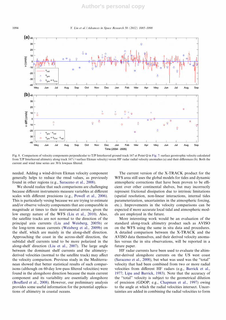
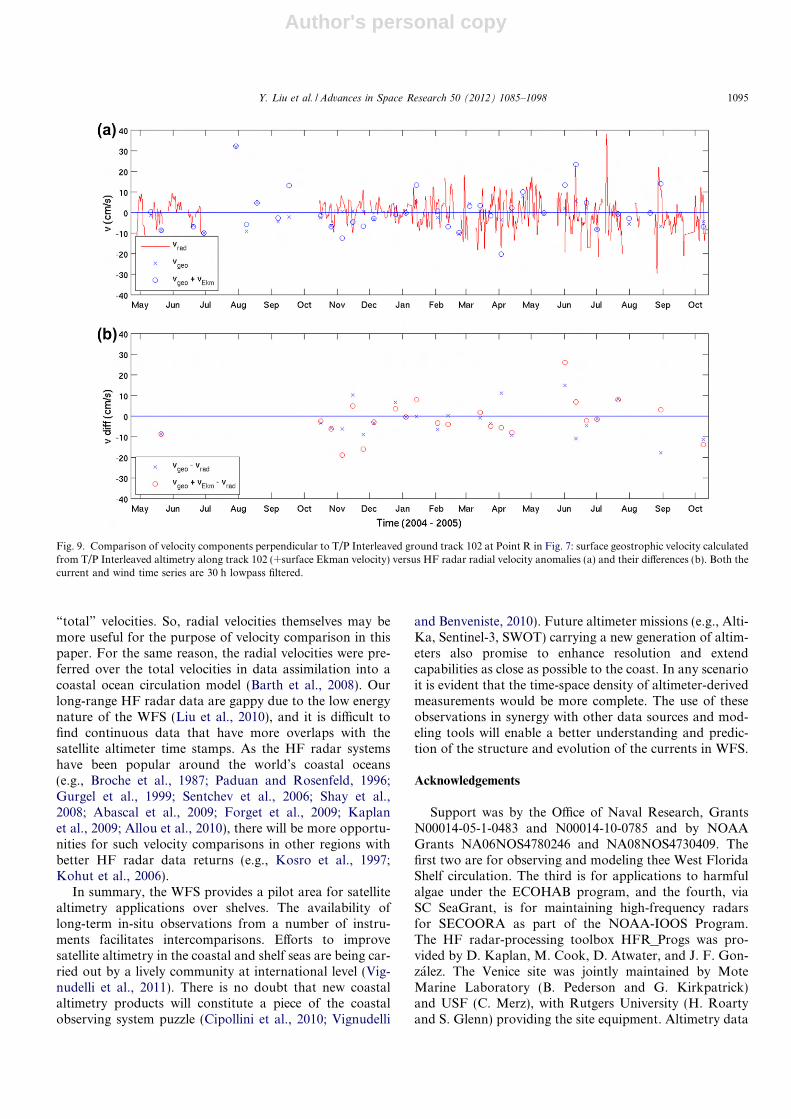
All the above comparisons with ADCPs need velocityrotation/projection, either projecting the observed velocityto the direction perpendicular to the satellite track orrotating both estimated and observed velocities to thealong-shelf direction. HF radar mapped radial velocities(Fig. 7) offer a direct velocity comparison without velocityrotation if satellite ground tracks pass over the radarcoverage area. There is a point Q along the track that theHF radar radial current direction is perpendicular to thesatellite ground track (Fig. 1b). Since altimeter-derivedgeostrophic velocity is also in the across-track direction(line Q – Veni), the two velocity components can be directlycompared. Also, the effective depth of HF radar currentmeasurements is the top 1–2 m, which is more comparableto the altimeter-derived surface geostrophic velocity thanthe moored ADCP velocity top bins (4–5 m below surface).
Satellite ground tracks 102 and 167 of T/P interlacedorbit cross over the footprint of Venice HF radar on thecentral WFS (Fig. 1b). Velocity comparisons are made attwo points, Q and R, respectively. An average of the altim-eter-derived surface geostrophic velocities at three pointscentered at point Q (or R) is applied to obtain vgeo time ser-ies. Similarly, an average of the HF radar radial velocitiesat the sectors at and around point Q (or R) is used as vrad
time series. The spatial ranges of the radial data points usedfor averages are shown in Fig. 1b as the small boxes, whichcontain three sectors in bearing and radial directions,respectively. The spatial average over adjacent sectorshelps to retain more data, which is necessary for the gappydata (Liu et al., 2010); however, it might also bring inuncertainties. After 36 h low-pass filtering, not much HF
Fig. 4. Time-lagged (a) correlation coefficient (n2) and (b) root-mean-squared difference (rmsd) between the altimetry-derived and observedalong-shelf velocity at mooring C12. Positive time lag means mooredvelocity lags the altimetry-derived velocity. The time lags corresponding tothe maximum n2 and the minimum rmsd values are shown.
Y. Liu et al. / Advances in Space Research 50 (2012) 1085–1098 1091

Author's personal copy
radar data are left. So, we opt with a shorter cut-off (30 h)and retain more data points in the vrad time series. Compar-ison is performed on a period with good HF radar datareturn during 2004–2005.
Point Q is located on the inner shelf (Figs. 1b and 7),closer to the coast than the points (P and R) around the50 m isobath, and the standard deviation of the altimeter-derived surface geostrophic velocity is slightly larger thanthose at point P. The standard deviation is reduced to9.3 cm/s when surface Ekman velocity component is takeninto account (Fig. 8), but it is still much larger than thestandard deviation of the HF radar radial velocity(4.9 cm/s). Similar to those of moored ADCP comparisons,Ekman velocity component helps to reduce the rmsdbetween vgeo and vrad and the standard deviation of thevelocity difference.
Point R is located on the mid shelf (Figs. 1b and 7), andthe standard deviation of the HF radar radial currents islarger than that at inner shelf point Q (7.9 vs. 4.9 cm/s) .This is because surface currents have larger variability(Fig. 7), and the ellipses of the principal axis currents areless eccentric, on the mid to outer shelf than on the innershelf (e.g., Liu and Weisberg, 2005a; Weisberg et al.,2009b). The standard deviation of vgeo is smaller than thatat point Q (3.8 vs. 10.3 cm/s), the reasons are two fold. (1)Here vgeo at point R is essentially an across-shelf velocitycomponent, while that at point Q has both along- and
across-shelf components. Note that geostrophic balance isthe dominant dynamics in the across-shelf momentumequation (v ¼ g
f@h@x) on the WFS, but not so in the along-
shelf direction where the pressure gradient, surface andbottom stresses are all important (Liu and Weisberg,2005b). When surface stress (Ekman velocity component)is considered, the standard deviation of (vgeo + vEkm) isincreased to 9.7 cm/s, closer to that of the observed (vrad),7.9 cm/s (Fig. 9). (2) The quality of coastal altimetry gener-ally decreases towards the coast, and uncertainties in theestimated vgeo increase when getting closer to the shore.Adding Ekman component does not reduce the rmsdbetween the estimated and the observed velocity anomaliesor the standard deviation of the velocity difference, becausethese values are already very low.
6. Summary and discussions
Based on multiple-year ocean current observations froma coastal ocean observation system on the West FloridaShelf, the altimetry product provided by the X-TRACKsoftware is assessed for potential usefulness in inferringcoastal ocean circulation information over a wide conti-nental shelf. Across-track, surface geostrophic velocitycomponent anomalies, derived from the along-track SLAslope remotely sensed by altimeters onboard the T/P, J1,and T/P interlaced orbit satellite missions are compared
Fig. 5. Comparison of along-shelf velocity components at the 50 m isobath: surface geostrophic velocity calculated from J1 altimetry along track 091(+surface Ekman velocity) versus ADCP near-surface (4 m) velocity anomalies at mooring C12 (a) and their differences (b). Both the ADCP and wind timeseries are 36 h lowpass filtered.
1092 Y. Liu et al. / Advances in Space Research 50 (2012) 1085–1098

Author's personal copy
with the near surface velocity components from mooredADCP observations at mid shelf (around the 50 misobath). The altimeter-derived velocity componentanomalies are also compared with surface (radial) velocitycomponents by HF radar as sampled perpendicular to thesatellite track.
Preliminary results indicate the potential usefulness ofthe coastal altimetry product, which can be seen from thecomparisons of the estimated and observed velocity anom-aly time series. The root-mean-square difference (rmsd)between the estimated and the ADCP or HF radarobserved near surface velocity component anomalies are8–11 vcm/s on subtidal time scales. Given expected velocityerrors of 4–6 cm/s from the optimal filter (Powell andLeben, 2004), and rmsd of �6 cm/s for deep oceans (e.g.,Strub et al., 1997), these 8–11 cm/s rmsd values are encour-aging and are similar to those found by Le Henaff et al.(2011) with high resolution coastal altimetry along thecontinental slope of Spain. This indicates usefulness ofthe X-TRACK product on the WFS. Note there is an rmsdof 3–6 cm/s between the HF radar and ADCP near-surfacevelocities on subtidal time scales over the WFS (Liu et al.,2010). The smaller rmsd values around the 50 m isobathfrom HF radar data than the moored ADCP data maybe due to better comparability of the HF radar data, i.e.,the radar data are measured at surface, and the compari-sons are performed at the same points and the samedirections (radial current direction is the same as theacross-track direction) that velocity projection is not
Fig. 6. Same as Fig. 5 but for mooring C13.
Fig. 7. A snapshot of HF radar radial velocity field superimposed on theroot-mean-squared (rms) values of the 30 h lowpass filtered radial currents(color) as measured from the Venice site. The radial velocities aresubsampled for clarity. Bathymetry units in meters. Also shown are thesatellite ground tracks from the T/P interleaved mission, and the two points(Q and R) where the across-track directions are the same as the radialcurrent directions.
Y. Liu et al. / Advances in Space Research 50 (2012) 1085–1098 1093
Author's personal copy
needed. Adding a wind-driven Ekman velocity componentgenerally helps to reduce the rmsd values, as previouslyfound in other regions (e.g., Saraceno et al., 2008).
We should realize that such comparisons are challengingbecause different instruments measure variables at differentscales with different precisions (e.g., Powell et al., 2006).This is particularly vexing because we are trying to estimateand/or observe velocity components that are comparable inmagnitude at times to their instrumental errors, given thelow energy nature of the WFS (Liu et al., 2010). Also,the satellite tracks are not normal to the direction of theprincipal axis currents (Liu and Weisberg, 2005b) orthe long-term mean currents (Weisberg et al., 2009b) onthe shelf, which are mainly in the along-shelf direction.Approaching the coast in the across-shelf direction, thesubtidal shelf currents tend to be more polarized in thealong-shelf direction (Liu et al., 2007). The large anglebetween the dominant shelf currents and the altimetry-derived velocities (normal to the satellite track) may affectthe velocity comparison. Previous study in the Mediterra-nean showed that better statistical results of such compar-isons (although on 60-day low-pass filtered velocities) werefound in the alongshore direction because the main currentcomponent and its variability are essentially alongshore(Bouffard et al., 2008). However, our preliminary analysisprovides some useful information for the potential applica-tions of altimetry in coastal oceans.
The current version of the X-TRACK product for theWFS area still uses the global models for tides and dynamicatmospheric corrections that have been proven to be effi-cient over other continental shelves, but may incorrectlyrepresent frictional dissipation due to intrinsic limitations(spatial resolution, non-linear interactions, internal tidesparameterization, uncertainties in the atmospheric forcing,etc.). Improvements in the velocity comparisons can beexpected if more accurate local tidal and atmospheric mod-els are employed in the future.
More interesting work would be an evaluation of thestandard along-track altimetry product such as AVISOon the WFS using the same in situ data and procedures.A detailed comparison between the X-TRACK and theAVISO data themselves, and their derived velocity anoma-lies versus the in situ observations, will be reported in afuture paper.
HF radar currents have been used to evaluate the altim-eter-derived alongshore currents on the US west coast(Saraceno et al., 2008), but what was used was the “total”velocity that had been combined from two or more radialvelocities from different HF radars (e.g., Barrick et al.,1977; Lipa and Barrick, 1983). Note that the accuracy ofthe “total” velocity is subject to the geometrical dilutionof precision (GDOP; e.g., Chapman et al., 1997) owingto the angle at which the radial velocities intersect. Uncer-tainties are added in combining the radial velocities to form
Fig. 8. Comparison of velocity components perpendicular to T/P Interleaved ground track 167 at Point Q in Fig. 7: surface geostrophic velocity calculatedfrom T/P Interleaved altimetry along track 167 (+surface Ekman velocity) versus HF radar radial velocity anomalies (a) and their differences (b). Both thecurrent and wind time series are 30 h lowpass filtered.
1094 Y. Liu et al. / Advances in Space Research 50 (2012) 1085–1098
Author's personal copy
“total” velocities. So, radial velocities themselves may bemore useful for the purpose of velocity comparison in thispaper. For the same reason, the radial velocities were pre-ferred over the total velocities in data assimilation into acoastal ocean circulation model (Barth et al., 2008). Ourlong-range HF radar data are gappy due to the low energynature of the WFS (Liu et al., 2010), and it is difficult tofind continuous data that have more overlaps with thesatellite altimeter time stamps. As the HF radar systemshave been popular around the world’s coastal oceans(e.g., Broche et al., 1987; Paduan and Rosenfeld, 1996;Gurgel et al., 1999; Sentchev et al., 2006; Shay et al.,2008; Abascal et al., 2009; Forget et al., 2009; Kaplanet al., 2009; Allou et al., 2010), there will be more opportu-nities for such velocity comparisons in other regions withbetter HF radar data returns (e.g., Kosro et al., 1997;Kohut et al., 2006).
In summary, the WFS provides a pilot area for satellitealtimetry applications over shelves. The availability oflong-term in-situ observations from a number of instru-ments facilitates intercomparisons. Efforts to improvesatellite altimetry in the coastal and shelf seas are being car-ried out by a lively community at international level (Vig-nudelli et al., 2011). There is no doubt that new coastalaltimetry products will constitute a piece of the coastalobserving system puzzle (Cipollini et al., 2010; Vignudelli
and Benveniste, 2010). Future altimeter missions (e.g., Alti-Ka, Sentinel-3, SWOT) carrying a new generation of altim-eters also promise to enhance resolution and extendcapabilities as close as possible to the coast. In any scenarioit is evident that the time-space density of altimeter-derivedmeasurements would be more complete. The use of theseobservations in synergy with other data sources and mod-eling tools will enable a better understanding and predic-tion of the structure and evolution of the currents in WFS.
Acknowledgements
Support was by the Office of Naval Research, GrantsN00014-05-1-0483 and N00014-10-0785 and by NOAAGrants NA06NOS4780246 and NA08NOS4730409. Thefirst two are for observing and modeling thee West FloridaShelf circulation. The third is for applications to harmfulalgae under the ECOHAB program, and the fourth, viaSC SeaGrant, is for maintaining high-frequency radarsfor SECOORA as part of the NOAA-IOOS Program.The HF radar-processing toolbox HFR_Progs was pro-vided by D. Kaplan, M. Cook, D. Atwater, and J. F. Gon-zalez. The Venice site was jointly maintained by MoteMarine Laboratory (B. Pederson and G. Kirkpatrick)and USF (C. Merz), with Rutgers University (H. Roartyand S. Glenn) providing the site equipment. Altimetry data
Fig. 9. Comparison of velocity components perpendicular to T/P Interleaved ground track 102 at Point R in Fig. 7: surface geostrophic velocity calculatedfrom T/P Interleaved altimetry along track 102 (+surface Ekman velocity) versus HF radar radial velocity anomalies (a) and their differences (b). Both thecurrent and wind time series are 30 h lowpass filtered.
Y. Liu et al. / Advances in Space Research 50 (2012) 1085–1098 1095

Author's personal copy
used in this study were developed, validated, and distrib-uted by the CTOH/LEGOS, France. Financial supportby CNES is acknowledged (MARINA OST-ST project).This is CPR contribution 18.
References
Abascal, A.J., Castanedo, S., Medina, R., Losada, I.J., Alvarez-Fanjul, E.Application of HF radar currents to oil spill modeling. Mar. Pollut.Bull. 58, 238–248, 2009.
Allou, A., Forget, P., Devenon, J.-L. Submesoscale vortex structures atthe entrance of the Gulf of Lions in the Northwestern MediterraneanSea. Cont. Shelf Res. 30 (7), 724–732, 2010.
Alvera-Azcarate, A., Barth, A., Weisberg, R.H. The surface circulation ofthe Caribbean Sea and the Gulf of Mexico as inferred from satellitealtimetry. J. Phys. Oceanogr. 39, 640–657, 2009.
Andersen, O.B. Shallow water tides on the northwest European shelf fromTOPEX/ POSEIDON altimetry. J. Geophys. Res. 104, 7729–7741,1999.
Anzenhofer, M., Shum, C. K., Rentsh, M. Costal altimetry andapplications, Tech. Rep. n. 464, Geodetic Science and Surveying,The Ohio State University Columbus, USA, 1999.
Aviso User Handbook: Merged Topex/Poseidon Products, http://www.aviso.oceanobs.com/fileadmin/documents/data/tools/hdbk_tp_gdrm.pdf, AVI-NT-02-101-CN, Edition 3.0, July 1996.
Aviso and PoDaac User Handbook - IGDR and GDR Jason-1 Products,http://www.aviso.oceanobs.com/fileadmin/documents/data/tools/hdbk_j1_gdr.pdf, SMM-MU-M5-OP-13184-CN, Edition 4.1, October2008.
Barrick, D.E., Evans, M.W., Weber, B.L. Ocean surface currents mappedby radar. Science 198, 138–144, 1977.
Barth, A., Alvera-Azcarate, A., Weisberg, R.H. Assimilation of high-frequency radar currents in a nested model of the West Florida Shelf.J. Geophys. Res. 113, C08033, doi:10.1029/2007JC004585, 2008.
Benveniste, J. Radar altimetry: past, present and future, in: Vignudelli, S.,Kostianoy, A.G., Cipollini, P., Benveniste, J. (Eds.), Coastal Altim-etry. Springer-Verlag, Berlin, Heidelberg, pp. 1–17, doi:10.1007/978-3-642-12796-0_1, 2011.
Birol, F., Cancet, M., Estournel, C. Aspects of the seasonal variability ofthe Northern Current (NW Mediterranean Sea) observed by altimetry.J. Marine Syst. 81, 297–311, 2010.
Blanton, J.O., Oey, L.-Y., Amft, J., Lee, T.N. Advection of momentumand buoyancy in a coastal frontal zone. J. Phys. Oceanogr. 19, 98–115,1989.
Bouffard, J., Vignudelli, S., Cipollini, P., Menard, Y. Exploiting thepotential of an improved multimission altimetric data set over thecoastal ocean. Geophys. Res. Lett. 35, L10601, doi:10.1029/2008GL033488, 2008.
Bouffard, J., Roblou, L., Birol, F., Pascual, A., Fenoglio-Marc, L.,Cancet, M., Morrow, R., Menard, Y. Introduction and assessment ofimproved coastal altimetry strategies: case study over the Northwest-ern Mediterranean Sea, in: Vignudelli, S., Kostianoy, A.G., Cipollini,P., Benveniste, J. (Eds.), Coastal Altimetry. Springer-Verlag, Berlin,Heidelberg, pp. 297–330, doi:10.1007/978-3-642-12796-0_12, 2011,2011.
Broche, P., Forget, P., de Maisire, J.C., Devenon, J.L., Crochet, M. VHFradar for ocean surface current and sea state remote sensing. RadioSci. 22 (1), 69–75, doi:10.1029/RS022i001p00069, 1987.
Brown, S. A novel near-land radiometer wet path-delay retrievalalgorithm: application to the Jason-2/OSTM Advanced MicrowaveRadiometer. Trans. Geoac. Rem. Sens., doi:10.1109/TGRS.2009.2037220, 2010.
Carlson, D.F., Clarke, A.J. Seasonal along-isobath geostrophic flows onthe west Florida shelf with application to Karenia brevis red tideblooms in Florida’s Big Bend. Continen. Shelf Res. 29, 445–455, 2009.
Carrere, L., Lyard, F. Modeling the barotropic response of the globalocean to atmospheric wind and pressure forcing – comparisons with
observations. Geophys. Res. Lett. 30 (6), 1275, doi:10.1029/2002GL016473, 2003.
Cartwright, D.E., Taylor, R.J. New computations of the tide-generatingpotential, Geophys. J. Roy. Astron. Soc. 23, 45–74, 1971.
Chambers, D.P., Hayes, S.A., Ries, J.C., Urban, T.J. New TOPEX seastate bias models and their effect on global mean sea level. J. Geophys.Res. 108 (C10), 3305, doi:10.1029/2003JC001839, 2003.
Chapman, R.D., Shay, L.K., Graber, H.C., Edson, J.B., Karachintsev, A.,Trump, C.L., Ross, D.B. On the accuracy of HF radar surface currentmeasurements: intercomparisons with ship-based sensors. J. Geophys.Res. 102 (C8), 18737–18748, 1997.
Chelton, D.B. Overview of the high-resolution ocean topography scienceworking group meeting, in: Report of the High-Resolution OceanTopography Science, 2001.
Cipollini, P., Benveniste, J., Bouffard, J., Emery, W., Gommenginger, C.,Griffin, D., Høyer, J., Madsen, K., Mercier, F., Miller, L., Pascual, A.,Ravichandran, M., Shillington, F., Snaith, H., Strub, T., Vandemark,D., Vignudelli, S., Wilkin, J., Woodworth, P., Zavala-Garay, J. Therole of altimetry in coastal observing systems, in: Hall, J., Harrison,D.E., Stammer, D. (Eds.), Proceedings of OceanObs’09: SustainedOcean Observations and Information for Society (Vol. 2), Venice,Italy, 21–25 September 2009, ESA Publication WPP-306, doi:10.5270/OceanObs09.cwp.16, 2010.
Cipollini, P., Vignudelli, S., Lyard, F., Roblou, L. 15 Years of altimetry atvarious scales over the Mediterranean, in: Barale, V., Gade, M. (Eds.),Remote Sensing of the European Seas. Springer, Berlin, Germany, pp.295–306, 2008.
Deng, X., Featherstone, W., Hwang, C., Berry, P.A.M. Estimation ofcontamination of ERS-2 and Poseidon satellite radar altimetry close tothe coasts of Australia. Marine Geodesy 25, 249–271, 2002.
Deng, X., Hwang, C., Coleman, R., Featherstone, W.E. Seasonal andinterannual variations of the Leeuwin current off Western Australiafrom TOPEX/Poseidon satellite altimetry. Terr. Atmos. Ocean. Sci.19, 135–149, doi:10.3319/TAO.2008.19.1-2.135, SA, 2008.
Dong, S., Kelly, K.A. Seasonal and interannual variations in geostrophicvelocity in the Middle Atlantic Bight. J. Geophys. Res. 108, C063172,doi:10.1029/2002JC001357, 2003.
Ducet, N., Le Traon, P.Y., Reverdin, G. Global high resolution mappingof ocean circulation from the combination of TOPEX/ POSEIDONand ERS-1/2. J. Geophys. Res. 105 (C8), 19477–19498, 2000.
Durand, F., Shankar, D., Birol, F., Shenoi, S.S.C. Estimating boundarycurrents from satellite altimetry: a case study for the East coast ofIndia. J. Oceanogr. 64 (6), 831–845, 2008.
Durand, F., Shankar, D., Birol, F., Shenoi, S.S.C. Spatiotemporalstructure of the East India coastal current from satellite altimetry. J.Geophys. Res. 114, C02013, doi:10.1029/2008JC004807, 2009.
Dussurget, R., Birol, F., Morrow, R., De Mey, P. Fine resolutionaltimetry data for a regional application in the Bay of Biscay. Mar.Geodesy, 34, Special Issue on Jason-2 Calibration/Validation, Part II,2011.
Ekman, V.W. On the influence of the earth’s rotation in ocean-currents.Arch. Math. Astron. Phys. 2, 1–52, 1905.
Emery, W.J., Strub, T., Leben, R., Foreman, M., McWilliams, J.C.,Han, G., Ladd, C., Ueno, H. Satellite altimetry applications off thecoasts of North America, in: Vignudelli, S., Kostianoy, A.G.,Cipollini, P., Benveniste, J. (Eds.), Coastal Altimetry. Springer-Verlag, Berlin Heidelberg, pp. 417–451, doi:10.1007/978-3-642-12796-0_16, 2011.
Foreman, M.G.G., Crawford, W.R., Cherniawsky, J.Y., Gower, J.F.R.,Cuypers, L., Ballantyne, V.A. Tidal correction of TOPEX/ POSEI-DON altimetry for seasonal sea surface elevation and currentdetermination off the Pacific coast of Canada, J. Geophys. Res. 103(C12), 27979–27998, 1998.
Forget, P. Barbin, Y. Andre, G., 2009. Monitoring of Surface OceanCirculation in the Gulf of Lions (North-West Mediterranean Sea)Using WERA HF Radars. Geoscience and Remote Sensing Sympo-sium, 2008. IGARSS 2008. IEEE International doi :10.1109/IGARSS.2008.4778872.
1096 Y. Liu et al. / Advances in Space Research 50 (2012) 1085–1098
Author's personal copy
Fu, L.-L., Chelton, D.B. Temporal variability of the Antarctic Circum-polar Current observed from satellite altimetry. Science 226, 343–346,1984.
Gaspar, P., Labroue, S., Ogor, F., Lafitte, L., Marchal, L., Rafanel, M.Improving nonparametric estimates of the sea state bias in radaraltimeter measurements of sea level. J. Atmos. Oceanic Technol. 19,1690–1707, 2001.
Godin, O.A., Irisov, V.G., Leben, R.R., Hamlington, B.D., Wick, G.A.Variations in sea surface roughness induced by the 2004 Sumatra-Andaman tsunami. Nat. Hazards Earth Syst. Sci. 9, 1135–1147, 2009.
Gurgel, K.-W., Antonischki, G., Essen, H.-H., Schlick, T. Wellen Radar(WERA), a new ground-wave-based HF radar for ocean remotesensing. Coastal Eng. 37, 219–234, 1999.
Han, G. Scotian Slope circulation and eddy variability from TOPEX/Poseidon and frontal analysis data. J. Geophys. Res. 109, C03028,doi:10.1029/2003JC002046, 2004a.
Han, G. TOPEX/Poseidon-Jason comparison and combination off NovaScotia. Marine Geodesy 27, 577–595, 2004b.
Han, G. Low-frequency variability of sea level and currents offNewfoundland. Adv. Space Res. 38, 2141–2161, 2006.
Han, G., Ikeda, M., Smith, P.C. Annual variation of sea surface slopesover the Scotian Shelf and Grand Banks from Geosat altimetry.Atmos. Ocean 31 (4), 591–615, 1993.
Han, G., Tang, C.L., Smith, P.C. Annual variations of sea surfaceelevations and currents over the Scotian Shelf and slope. J. Phys.Oceanogr. 32, 1794–1810, 2002.
Han, G. Satellite observations of seasonal and interannual changes of sealevel and currents over the Scotian slope. J. Phys. Oceanogr. 37, 1051–1065, 2007.
He, R., Weisberg, R.H. A case study of the loop current intrusion on theWest Florida Shelf. J. Phys. Oceanogr. 33, 465–477, 2003.
Herbert, G., Ayoub, N., Marsaleix, M., Lyard, F. Signature of the coastalcirculation variability in altimetric data in the southern Bay of Biscayduring winter and fall 2004. J. Mar. Sys. doi: 10.1016/j.jmar-sys.2011.03.004, 2011.
Johnson, E.S., Bonjean, F., Lagerloef, G.S.E., Gunn, J.T., Mitchum, G.T.Validation and error analysis of OSCAR Sea-surface currents. J.Atmos. Oceanic Technol. 24 (4), 688–701, 2007.
Kaplan, D.M., Halle, C., Paduan, J., Largier, J.L. Surface currents duringanomalous upwelling seasons off central California. J. Geophys. Res.114, C12026, doi:10.1029/2009JC005382, 2009.
Kelly, K.A., Gille, S.T. Gulf stream surface transport and statistics at69�W from the Geosat altimeter. J. Geophys. Res. 95, 3149–3161,1990.
Kelly, K.A., Beardsley, R.C., Limeburner, R., Brink, K.H., Paduan, J.D.,Chereskin, T.K. Variability of the near-surface eddy kinetic energy inthe California current based on altimeter, drifter and moored currentmeter data. J. Geophys. Res. 103, 13067–13083, 1998.
Kohut, J.T., Glenn, S.M. Calibration of HF radar surface currentmeasurements using measured antenna beam patterns. J. Atmos.Oceanic Technol. 20, 1303–1316, 2003.
Kohut, J.T., Roarty, H.J., Glenn, S.M. Characterizing observed environ-mental variability with HF Doppler radar surface current mappers andacoustic doppler current profilers: environmental variability in thecoastal ocean. IEEE J. Oceanic Eng. 31, 876–884, 2006.
Kosro, P.M., Barth, J.A., Strub, T.P. The coastal jet: observations ofsurface currents over the Oregon continental shelf from HF radar.Oceanography 10, 53–57, 1997.
Lagerloef, G.S.E., Lukas, R., Bonjean, F., Gunn, J.T., Mitchum, G.T.,Bourassa, M., Busalacchi, A.J. El Nino tropical Pacific Ocean surfacecurrent and temperature evolution in 2002 and outlook for early 2003.Geophys. Res. Lett. 30 (10), 1514, doi:10.1029/2003GL017096, 2003.
Leben, R. R. Altimeter-derived loop current metrics. In Circulation in theGulf of Mexico: Observations and models, in: Sturges, W., Lugo-Fernandez, A. (Eds.), AGU Geophysical Monograph Series, Vol. 161,pp. 181–202, 2005.
Leben, R.R., Born, G.H. Tracking loop current eddies with satellitealtimetry. Adv. Space Res. 13, 325–333, 1993.
Leben, R.R., Powell, B.S. Accuracy assessment of Jason-1 and TOPEX/POSEIDON along-track sea surface slope. Marine Geodesy 26, 355–366, 2003.
Le Henaff, M., Roblou, L., Bouffard, J. Characterizing the NavidadCurrent interannual variability using coastal altimetry. Ocean Dynam.61 (4), 425–437, 2011.
Lenn, Y.-D., Chereskin, T.K. Observations of Ekman Currents in theSouthern Ocean. J. Phys. Oceanogr. 39, 768–779, 2009.
Le Provost, C. Ocean tides. Satellite altimetry and Earth sciences, in: Fu,L.-L., Cazenave, A. (Eds.), A Handbook of Techniques and Appli-cations. Academic Press, pp. 267–303, 2001.
Le Traon, P.-Y., Morrow, R.A. Ocean currents and mesoscale eddies.Satellite Altimetry and Earth sciences, in: Fu, L.-L., Cazenave, A.(Eds.), A Handbook of Techniques and Applications. Academic Press,pp. 171–215, 2001.
LeTraon, P.Y., Faugere, Y., Hernandez, F., Dorandeu, J., Merttz, F.,Ablain, M. Can we merge GEOSAT-follow-on with TOPEX/Poseidonand ERS-2 for an improved description of the ocean circulation? J.Atmos. Oceanic Technol. 20, 889–895, 2003.
Li, J., Clarke, A.J. Interannual flow along the northern coast of the Gulfof Mexico. J. Geophys. Res. 110, C11002, doi:10.1029/2004JC002606,2005.
Lipa, B.J., Barrick, D.E. Least-squares method for the extraction ofsurface currents from CODAR cross-loop data: application atARSLOE. IEEE J. Oceanic Eng. OE-8, 226–253, 1983.
Liu, Y., Weisberg, R.H. Momentum balance diagnoses for the WestFlorida Shelf. Cont. Shelf Res. 25, 2054–2074, 2005a.
Liu, Y., Weisberg, R.H. Patterns of ocean current variability on the WestFlorida Shelf using the self-organizing map. J. Geophys. Res. 110,C06003, doi:10.1029/2004JC002786, 2005b.
Liu, Y., Weisberg, R.H., Shay, L.K. Current patterns on the West Floridashelf from joint self-organizing map analyses of HF radar and ADCPdata. J. Atmos. Oceanic Technol. 24, 702–712, 2007.
Liu, Y., Weisberg, R.H. Ocean currents and sea surface heights estimatedacross the West Florida Shelf. J. Phys. Oceanogr. 37 (6), 1697–1713,2007.
Liu, Y., Weisberg, R.H., Yuan, Y. Patterns of upper layer circulationvariability in the South China Sea from satellite altimetry using theself-organizing map. Acta Oceanol. Sinica 27 (Supp.), 129–144, 2008.
Liu, Y., Weisberg, R.H., Merz, C.R., Lichtenwalner, S., Kirkpatrick, G.J.HF radar performance in a low-energy environment: CODARSeaSonde experience on the West Florida Shelf. J. Atmos. OceanicTechnol. 27, 1689–1710, doi:10.1175/2010JTECHO720.1, 2010.
Madsen, K.S., Høyer, J.L., Tscherning, C.C. Near-coastal satellitealtimetry: Sea surface height variability in the North Sea–Baltic Seaarea. Geophys. Res. Lett. 34, L14601, doi:10.1029/2007GL029965,2007.
Mayer, D.A., Virmani, J.I., Weisberg, R.H. Velocity comparisons fromupward and downward acoustic doppler current profilers on the WestFlorida Shelf. J. Atmos. Ocean Tech. 24, 1950–1960, 2007.
Melet, A., Gourdeau, L., Verron, J. Variability in Solomon Sea circulationderived from altimeter sea level data. Ocean Dynam. 60, 883–900,2010.
Menkes, C., Boulanger, J.P., Busalacchi, A.J. Evaluation of TOPEX andbasin-wide tropical Ocean and global atmosphere–tropical atmosphereOcean sea surface topographies and derived geostrophic currents. J.Geophys. Res. 100, 25087–25100, 1995.
Meyers, S.D., Siegel, E.M., Weisberg, R.H. Observations of currents onthe west Florida shelf break. Geophys. Res. Lett. 28, 2037–2040, 2001.
Mitchell, D.A., Teague, W.J., Whitmer, K.R. Evidence that Sea State biasis different for ascending and descending tracks. Marine Geodesy 27,483–494, 2004.
Mitchum, G.T. An improved calibration of satellite altimetric heightsusing tide gauge sea levels with adjustment for land motion. MarineGeodesy 23, 145–166, 2000.
Mitchum, G.T., Hancock, D.W., Hayne, G.S., Vandemark, D.C. Bloomsof r0 in the TOPEX radar altimeter data. J. Atmos. Oceanic Technol.21, 1232–1245, 2004.
Y. Liu et al. / Advances in Space Research 50 (2012) 1085–1098 1097

Author's personal copy
Paduan, J.D., Rosenfeld, L.K. Remotely sensed surface currents inMonterey Bay from shore-based HF radar (coastal ocean dynamicsapplication radar). J. Geophys. Res. 101 (C9), 20669–20686, 1996.
Pascual, A., Gaugere, Y., Larnicol, G., LeTraon, P.Y. Improveddescription of the ocean mesoscale variability by combining foursatellite altimeters. Geophys. Res. Lett. 33, L02611, doi:10.1029/2005GL024633, 2006.
Ponte, R.M., Wunsch, C., Stammer, D. Spatial mapping of time-variableerrors in Jason-1 and TOPEX/POSEIDON sea surface heightmeasurements. J. Atmos. Oceanic Technol. 24, 1078–1085, 2007.
Powell, B.S., Leben, R.R. An optimal filter for geostrophic mesoscalecurrents from along-track satellite altimetry. J. Atmos. OceanicTechnol. 21, 1633–1642, 2004.
Powell, B.S., Leben, R.R., Guinasso, N.L. Comparison of Buoy andaltimeter-derived Shelf currents using an optimal operator. IEEEGeosci. Remote Sens. Lett. 3, 192–196, 2006.
Ray, R. D. A global ocean tide model from Topex/Poseidon altimetry:GOT99.2, NASA Tech Memo 209478, 58 p., 1999.
Ray, R.D. A preliminary tidal analysis of Icesat laser altimetry: SouthernRoss Ice Shelf. Geophys. Res. Lett. 35, L02505, doi:10.1029/2007GL032125, 2008.
Ray, R.D., Mitchum, G.T. Surface manifestation of internal tidesgenerated near Hawaii. Geophys. Res. Lett. 23 (16), 2101–2104, 1996.
Roblou, L., Lyard, F., Le Henaff, M., Maraldi, C. X-track, a newprocessing tool for altimetry in coastal oceans, in: ESA ENVISATSymposium, Montreux, Switzerland, April 23–27, 2007, ESA SP-636,2007.
Roblou, L., Lamouroux, J., Bouffard, J., Lyard, F., Le Henaff, M.,Lombard, A., Marsaleix, P., De Mey, P., Birol, F. Post-processingaltimeter data towards coastal applications and integration intocoastal models, in: Vignudelli, S., Kostianoy, A.G., Cipollini, P.,Benveniste, J. (Eds.), Coastal Altimetry. Springer-Verlag, Berlin,Heidelberg, pp. 217–246, doi:10.1007/978-3-642-12796-0_9, 2011.
Saraceno, M., Strub, P.T., Kosro, P.M. Estimates of sea surface heightand near surface alongshore coastal currents from combinations ofaltimeters and tide gauges. J. Geophys. Res. 113, C11013, doi:10.1029/2008JC004756, 2008.
Schlax, M.G., Chelton, D.B. Aliased tidal errors in TOPEX/POSEIDONsea surface height data. J. Geophys. Res. 99, 24761–24776, 1994.
Sentchev, A., Yaremchuk, M., Lyard, F. Residual circulation in theEnglish Channel as a dynamically consistent synthesis of shore-basedobservations of sea level and currents. Cont. Shelf Res. 26(16), 1884–1904. 10.1016/j.csr.2006.06.006, 2006.
Shay, L.K., Savidge, D., Styles, R., Seim, H., Weisberg, R.H. High-frequency radar observing systems in SEACOOS. Mar. Technol. Soc.J. 42, 55–67, 2008.
Stammer, D. Global characteristics of ocean variability estimated fromregional TOPEX/POSEIDON altimeter measurements. J. Phys. Oce-anogr. 27, 1743–1769, 1997.
Strub, P.T., Chereskin, T.K., Niiler, P.P., James, C., Levine, M.D.Altimeter derived variability of surface velocities in the Californiacurrent system: 1. Evaluation of TOPEX/POSEIDON altimetervelocity resolution. J. Geophys. Res. 102, 12727–12748, 1997.
Strub, P.T., James, C. Altimeter-derived variability of surface velocities inthe California current system: 2. Seasonal circulation and eddystatistics. Deep-Sea Res. II 47, 831–870, 2000.
Sturges, W., Leben, R.R. Frequency of ring separations from the loopcurrent in the Gulf of Mexico: a revised estimate. J. Phys. Oceanogr.30, 1814–1819, 2000.
Venegas, R.M., Strub, P.T., Beier, E., Letelier, R., Thomas, A.C., Cowles,T., James, C., Soto-Mardones, L., Cabrera, C. Satellite-derivedvariability in chlorophyll, wind stress, sea surface height, andtemperature in the northern California current system. J. Geophys.Res. 113, C03015, doi:10.1029/2007JC004481, 2008.
Vignudelli, S., Benveniste, J. Coastal altimetry progresses toward appli-cations. Eos Trans. AGU 91 (5), 45, 2010.
Vignudelli, S., Cipollini, P., Roblou, L., Lyard, F., Gasparini, G.P.,Manzella, G., Astraldi, M. Improved satellite altimetry in coastalsystems: case study of the Corsica Channel (Mediterranean Sea).Geophys. Res. Lett. 32, L07608, doi:10.1029/2005GL022602, 2005.
Vignudelli, S., Kostianoy, A.G., Cipollini, P., Benveniste, J. CoastalAltimetry, first ed., doi:10.1007/978-3-642-12796-0, 680 pp., ISBN:978-3-642-12795-3, 2011.
Volkov, D.L., Larnicol, G., Dorandeu, J. Improving the quality ofsatellite altimetry data over continental shelves. J. Geophys. Res. 112,C06020, doi:10.1029/2006JC003765, 2007.
Weisberg, R.H., Black, B.D., Yang, H. Seasonal modulation of the westFlorida continental shelf circulation. Geophys. Res. Lett. 23, 2247–2250, 1996.
Weisberg, R.H., Black, B.D., Li, Z. An upwelling case study on Florida’swest coast. J. Geophys. Res. 105, 11459–11469, 2000.
Weisberg, R. H., He, R., Liu, Y., Virmani, J. West Florida shelfcirculation on synoptic, seasonal, and inter-annual time scales, in:Sturges, W., Lugo-Fernandez, A. (Eds.), Circulation in the Gulf ofMexico: Observations and Models. Geophysical Monograph Series,Vol. 161, AGU Washington, D.C., pp. 325–347, 2005.
Weisberg, R.H., Barth, A., Alvera-Azcarate, A., Zheng, L. A coordinatedcoastal ocean observing and modeling system for the West FloridaShelf. Harmful Algae 8, 585–598, 2009a.
Weisberg, R.H., Liu, Y., Mayer, D.A. West Florida Shelf meancirculation observed with long-term moorings. Geophys. Res. Lett.36, L19610, doi:10.1029/2009GL040028, 2009b.
Zhao, Z., Alford, M.H., MacKinnon, J.A., Pinkel, R. Long-rangepropagation of the semidiurnal internal tide from the Hawaiian ridge.J. Phys. Oceanogr. 40, 713–736, doi:10.1175/2009JPO4207.1, 2010.
1098 Y. Liu et al. / Advances in Space Research 50 (2012) 1085–1098