Embed Size (px)
Citation preview
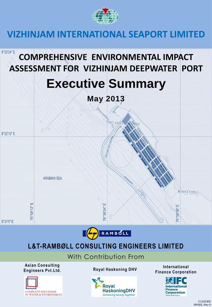
May 2013
C1101302
RP003, Rev 0
With Contribution From
Asian Consult ing
Engineers Pvt.Ltd. Royal Haskoning DHV International
Finance Corporation
VIZHINJAM INTERNATIONAL SEAPORT LIMITED
Executive Summary
COMPREHENSIVE ENVIRONMENTAL IMPACT ASSESSMENT FOR VIZHINJAM DEEPWATER PORT
L&T-RAMBØLL CONSULTING ENGINEERS LIMITED
RAMB LL
ISO 9001 :2008 COMPANY L&T-RAMBOLL CONSULTING ENGINEERS LIMITED
ORIGIN 0 Corporate Office:41h& 5th Floor. Triton Square (SKCL Building).C3-C7. Thiru-Vi-Ka Industrial Estale. Guindy. Chennai - 600 032. India.Phone: +91-44-22 9 Fax: +9t-44-22509600 E-mail: [email protected]
o Delhi Ci ffice :Plot N -29. Block-Bl Extension. Mohan Co-operative Industrial Estate. Mathura Road.N elhi-ll0 044 Ph: (011) 40538300 Fax' (011) 40538301 E-mail: [email protected]
yderabad City Office:Office Nos. 513 to 516. 51hFloor. Block III. White House. Kundan Bagh. Begumpet.Hyderabad - 500 016. Ph . 040-40354444, Fax: 40354430 E-mail: [email protected]
o Mumbai City Office:Ph' +91-22-24060477, [email protected]
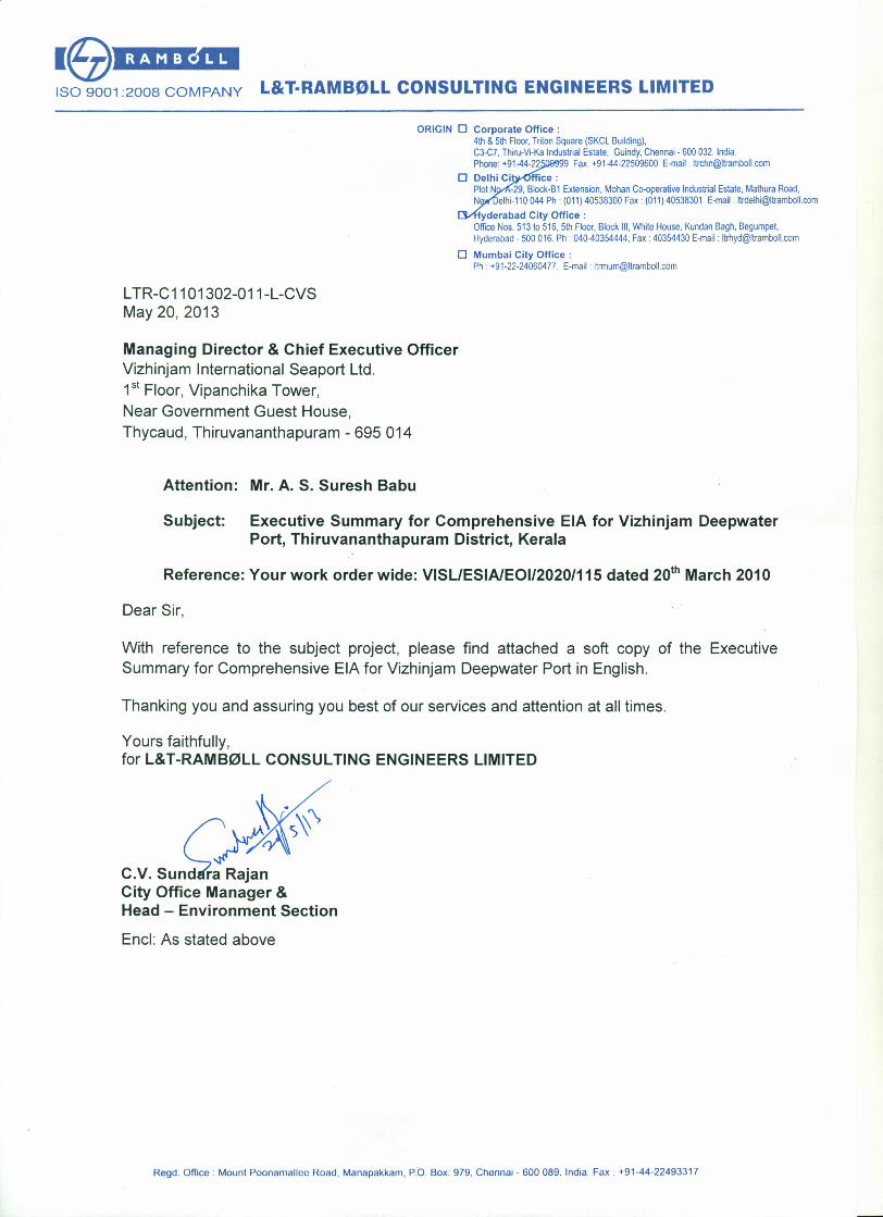
LTR-C11 01302-011-L-CVSMay 20,2013
Managing Director & Chief Executive OfficerVizhinjam International Seaport Ltd.1st Floor, Vipanchika Tower,Near Government Guest House,Thycaud, Thiruvananthapuram - 695014
Attention: Mr. A. S. Suresh Babu
Subject: Executive Summary for Comprehensive EIA for Vizhinjam DeepwaterPort, Thiruvananthapuram District, Kerala
Reference: Your work order wide: VISLIESIAlEOI/2020/115 dated zo" March 2010
Dear Sir,
With reference to the subject project, please find attached a soft copy of the ExecutiveSummary for Comprehensive EIA for Vizhinjam Deepwater Port in English.
Thanking you and assuring you best of our services and attention at all times.
Yours faithfully,for L&T-RAMB0LL CONSULTING ENGINEERS LIMITED
c.v.sun'~¥City Office Manager &Head - Environment Section
End: As stated above
Regd. Office: Mount Poonamallec Road. Manapakkam. P.O. Box: 979. Chennai - 600 089. India. Fax. +91-44-22493317
L&T-RAMBØLL
CONSULTING ENGINEERS LIMITED
Client: Vizhinjam International Seaport Limited Thiruvananthapuram, Kerala
Project: Comprehensive EIA for Vizhinjam Deepwater Port
Project No.:
C1101302
Title:
Executive Summary Document No.:
RP003
Rev.:
0 This document is the property of L&T-RAMBØLL CONSULTING ENGINEERS
LIMITED and must not be passed on to any person or body not authorised by us
to receive it nor be copied or otherwise made use of either in full or in part by such person or body without our prior permission in writing.
File path:
l:\ports\2010\c1101302 - eia for vizhinjham port\outputs\reports\003-executive summary\003-executive summary - english_27.05.2013.doc
Notes:
1.
Revision Details:
0 20.05.2013 First Submission JBF KRN CVS
Rev. Date Details Init. Sign. Init. Sign. Init. Sign.
Prepared Checked Approved

Comprehensive EIA for Vizhinjam Deepwater Port C1101302 Executive Summary RP003 rev. 0
1 Introduction Page i
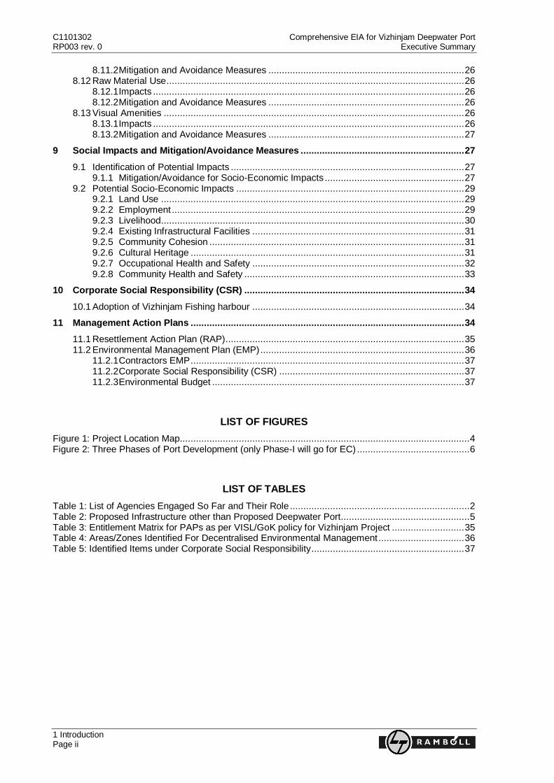
TABLE OF CONTENTS
1 Introduction .............................................................................................................................. 1
2 Environmental Impact Assessment (EIA) ................................................................................ 1
3 The Project Proponent ............................................................................................................. 2
4 Agencies Involved So Far ........................................................................................................ 2
5 The Project ................................................................................................................................ 3
6 Environmental Baseline ........................................................................................................... 7
6.1 Land Environment ............................................................................................................... 7 6.2 Water Environment.............................................................................................................. 7 6.3 Marine Environment ............................................................................................................ 8 6.4 Air Environment ..................................................................................................................10 6.5 Biological Environment .......................................................................................................10 6.6 Infrastructure and Public Utilities.........................................................................................11 6.7 Quarry Sites .......................................................................................................................12
7 Socio-Economic Baseline .......................................................................................................12
7.1 General Setting and Study Area .........................................................................................12 7.2 Social Survey .....................................................................................................................12 7.3 Population Profile ...............................................................................................................13 7.4 Economic Activities ............................................................................................................13 7.5 Fishing and Fishermen Villages ..........................................................................................14 7.6 Tourism ..............................................................................................................................14 7.7 Stakeholder Consultations ..................................................................................................15
8 Environmental Impacts and Mitigation/Avoidance Measures ...............................................16
8.1 Identification of Potential Impact Categories .......................................................................16 8.1.1 Potential Impacts ......................................................................................................16 8.1.2 Impact Mitigation and Avoidance Measures ..............................................................16
8.2 Land Environment ..............................................................................................................17 8.2.1 Impacts ....................................................................................................................17 8.2.2 Mitigation and Avoidance Measures .........................................................................17
8.3 Water Environment.............................................................................................................18 8.3.1 Impacts ....................................................................................................................18 8.3.2 Mitigation and Avoidance Measures .........................................................................18
8.4 Marine Environment ...........................................................................................................19 8.4.1 Impacts ....................................................................................................................19 8.4.2 Mitigation and Avoidance Measures .........................................................................19
8.5 Air Environment ..................................................................................................................20 8.5.1 Impacts ....................................................................................................................20 8.5.2 Mitigation and Avoidance Measures .........................................................................20
8.6 Noise and Vibration ............................................................................................................21 8.6.1 Impacts ....................................................................................................................21 8.6.2 Mitigation and Avoidance Measures .........................................................................21
8.7 Climate Change Vulnerability..............................................................................................22 8.7.1 Impacts ....................................................................................................................22 8.7.2 Mitigation and Avoidance Measures .........................................................................23
8.8 Solid Waste Management...................................................................................................24 8.8.1 Impacts ....................................................................................................................24 8.8.2 Mitigation and Avoidance Measures .........................................................................24
8.9 Flora ..................................................................................................................................25 8.10 Fauna ................................................................................................................................25 8.11 Marine Ecology ..................................................................................................................25
8.11.1 Impacts ....................................................................................................................25
C1101302 Comprehensive EIA for Vizhinjam Deepwater Port RP003 rev. 0 Executive Summary
1 Introduction Page ii
8.11.2 Mitigation and Avoidance Measures ......................................................................... 26 8.12 Raw Material Use ............................................................................................................... 26
8.12.1 Impacts .................................................................................................................... 26 8.12.2 Mitigation and Avoidance Measures ......................................................................... 26
8.13 Visual Amenities ................................................................................................................ 26 8.13.1 Impacts .................................................................................................................... 26 8.13.2 Mitigation and Avoidance Measures ......................................................................... 27
9 Social Impacts and Mitigation/Avoidance Measures ............................................................. 27
9.1 Identification of Potential Impacts ....................................................................................... 27 9.1.1 Mitigation/Avoidance for Socio-Economic Impacts .................................................... 27
9.2 Potential Socio-Economic Impacts ..................................................................................... 29 9.2.1 Land Use ................................................................................................................. 29 9.2.2 Employment ............................................................................................................. 29 9.2.3 Livelihood ................................................................................................................. 30 9.2.4 Existing Infrastructural Facilities ............................................................................... 31 9.2.5 Community Cohesion ............................................................................................... 31 9.2.6 Cultural Heritage ...................................................................................................... 31 9.2.7 Occupational Health and Safety ............................................................................... 32 9.2.8 Community Health and Safety .................................................................................. 33
10 Corporate Social Responsibility (CSR) .................................................................................. 34
10.1 Adoption of Vizhinjam Fishing harbour ............................................................................... 34
11 Management Action Plans ...................................................................................................... 34
11.1 Resettlement Action Plan (RAP) ......................................................................................... 35 11.2 Environmental Management Plan (EMP) ............................................................................ 36
11.2.1 Contractors EMP ...................................................................................................... 37 11.2.2 Corporate Social Responsibility (CSR) ..................................................................... 37 11.2.3 Environmental Budget .............................................................................................. 37
LIST OF FIGURES
Figure 1: Project Location Map ............................................................................................................ 4 Figure 2: Three Phases of Port Development (only Phase-I will go for EC) .......................................... 6
LIST OF TABLES
Table 1: List of Agencies Engaged So Far and Their Role ................................................................... 2 Table 2: Proposed Infrastructure other than Proposed Deepwater Port ................................................ 5 Table 3: Entitlement Matrix for PAPs as per VISL/GoK policy for Vizhinjam Project ........................... 35 Table 4: Areas/Zones Identified For Decentralised Environmental Management ................................ 36 Table 5: Identified Items under Corporate Social Responsibility ......................................................... 37
Comprehensive EIA for Vizhinjam Deepwater Port C1101302 Executive Summary RP003 rev. 0
1 Introduction Page 1
1 Introduction
The Government of Kerala (GoK) is planning to develop various port projects for the overall
improvement of the economy of the State. The State of Kerala, located along the West coast of India,
is endowed with a coastline of 580 km. Along this coast, there are 14 minor ports, three intermediate
ports and one major port i.e. Cochin. The minor ports and the intermediate ports come under the
jurisdiction of Department of Ports, GoK and the Cochin port is under the jurisdiction of Ministry of
Shipping, Government of India (GoI). Out of the minor/intermediate ports, Vizhinjam harbour is one
which has been accorded minor port status in 1977. Since then, a fishing harbour and a custom port
has been developed with limited facilities like a wharf and transit shed.
GoK is now going to develop a full-fledged container transhipment Greenfield port adjoining the
Vizhinjam Harbour; complete with cruise, coast guard and navy terminals. Vizhinjam International
Deepwater Multipurpose Seaport, herein after referred to as „Vizhinjam Deepwater Port‟ or simply
„Vizhinjam Port‟, has become a dream project for the people of Kerala and therefore the entire GoK
machinery is overwhelmingly supporting it. Due to its strategic location facing the Indian Ocean, its
proximity to the International Shipping Route, Tamil Nadu and Sri Lanka give it a special stature
making it a „National project’ rather than a „State project’. Vizhinjam port will be a significant
infrastructure development to cater to container trade in the Lower West coast region. These new
facilities could significantly impact the overall direction and dynamics of the container trade which will
positively affect the importing/exporting costs resulting in savings to the Indian consumer. This
document is the summary of comprehensive Environmental Impact Assessment (EIA) just concluded
during April 2013 for the project. The document is to comply with all National Environmental regulatory
requirements and National environmental standards for sustainable development.
2 Environmental Impact Assessment (EIA)
The EIA is prepared with three seasons primary data (comprehensive EIA) and the entire study took
more than 18 months due to the elaborate stakeholder consultation to meet GoI requirements. This
could, in fact, address most of the concerns raised by various stakeholders including the fishing and
tourism communities. The primary goal of this comprehensive EIA is to predict and assess the
project‟s potential adverse impacts and risks. The impacts identified will be used to identify (a) to
define a set of environmental and social mitigation and management measures to be taken up during
the implementation of the project and (b) to avoid, minimize or compensate/offset for risks and
adverse environmental and social impacts. Finally, an Environmental Management Plan (EMP) has
been formulated which consists of the necessary as well as mandatory plans for the development of
the Greenfield port and its road and rail connectivity.
Vizhinjam port is planned to be developed in three phases, however the scope of this study includes
the development of the port for phase-I and the development of the road and rail connectivity to the
port. The EIA is also prepared with respect to the infrastructural/ancillary facilities of the port like
warehouse, truck terminal, backup areas, etc. As per the September 2006 EIA notification of GoI, the
proposed Vizhinjam port is a “Category A” project as the proposed cargo handling capacity is ≥ 5.0
million Tonnes per Annum (TPA). Hence, Environmental Clearance (EC) from the Ministry of
Environment and Forest (MoEF), GoI is required. This EIA has been carried out as per MoEF‟s Terms
of Reference (ToR) and Guidance Manual for Ports and Harbour, Environmental, Health and Safety
(EHS) Guidelines for Ports, Harbour and Terminals, EHS Guidelines for Construction Materials
Extraction and EHS Guidelines for Crude Oil and Petroleum Product Terminals. As per the regulatory
requirements the environmental monitoring at site was carried out to collect three season primary data
C1101302 Comprehensive EIA for Vizhinjam Deepwater Port RP003 rev. 0 Executive Summary
3 The Project Proponent Page 2
on air, water, noise, soil in addition to marine environmental data relating to marine biological
parameters and physical oceanographic parameters (Water sediments and temperature) to prepare a
comprehensive EIA.
3 The Project Proponent
For developing the proposed Vizhinjam port, a fully owned GoK company named Vizhinjam
International Seaport Ltd, (VISL) was formed. VISL will undertake construction of breakwater, quay
wall, dredging, reclamation, utility and connectivity through Engineering, Procurement and
Construction (EPC) Contractor as per the Landlord Port Model, whereas the superstructure and
equipments will be erected by a concessionaire selected through a PPP route, who in turn will operate
the port for an initial concession period of 30 years. VISL will monitor the land acquisition for port
backup areas, road as well as rail connectivity and also the water/power supply required in both
construction and operation phases. The contact address of the VISL is as follows:
Managing Director & CEO, Vizhinjam International Seaport Ltd
1st Floor, Vipanchika Tower, Near Government Guest House,
Thycaud, Thiruvananthapuram - 695 014 Phone: 0471-2328616
E-mail: [email protected]
4 Agencies Involved So Far
Realising the importance of various required studies and surveys to comprehensively address all
issues, VISL/GoK has completed all such studies, surveys and investigations. Further as a best
practice and in terms of international standards the project has carried out several major, medium and
minor stakeholder consultations with the participation of all identified stakeholders. These identified
stakeholders include fishing communities, tourism related groups and institutions, road/rail project
affected communities, NGOs and other institutional stakeholders. In this context this project is perhaps
the first port project in India that could complete all required studies and stakeholder consultations to
an optimum level prior to the construction phase. Another important aspect of the project is the direct
involvement of elected representatives of all political classes and involvement of the Government
machinery itself. The importance of the project is also visible with the direct involvement and
participation of several ministers for the first time in an infrastructure project and their keenness to
listen and address all issues of the stakeholders. In this way, GoK/VISL is determined and committed
to address all genuine issues of project affected communities. The key role of VISL in development of
this port is to co-ordinate with various agencies playing significant roles in the development of this port.
The list of agencies involved and their role till date is given in the Table 1.
Table 1: List of Agencies Engaged So Far and Their Role
S. No. Agency Role/Study
1. International Finance Corporation
(IFC) Transaction Advisor
2. Royal Haskoning (RH) Technical Consultant Hired by IFC
3. AECOM Technical Consultant for EPC contract/ Master
Planning and DPR
4. Royal Haskoning/Asian Consulting
Engineers Pvt. Ltd. (ACE) ESIA Consultant for the Port, contracted by IFC
5. L&T-RAMBØLL Consulting Engineers ESIA for Road & Rail Connectivity, other
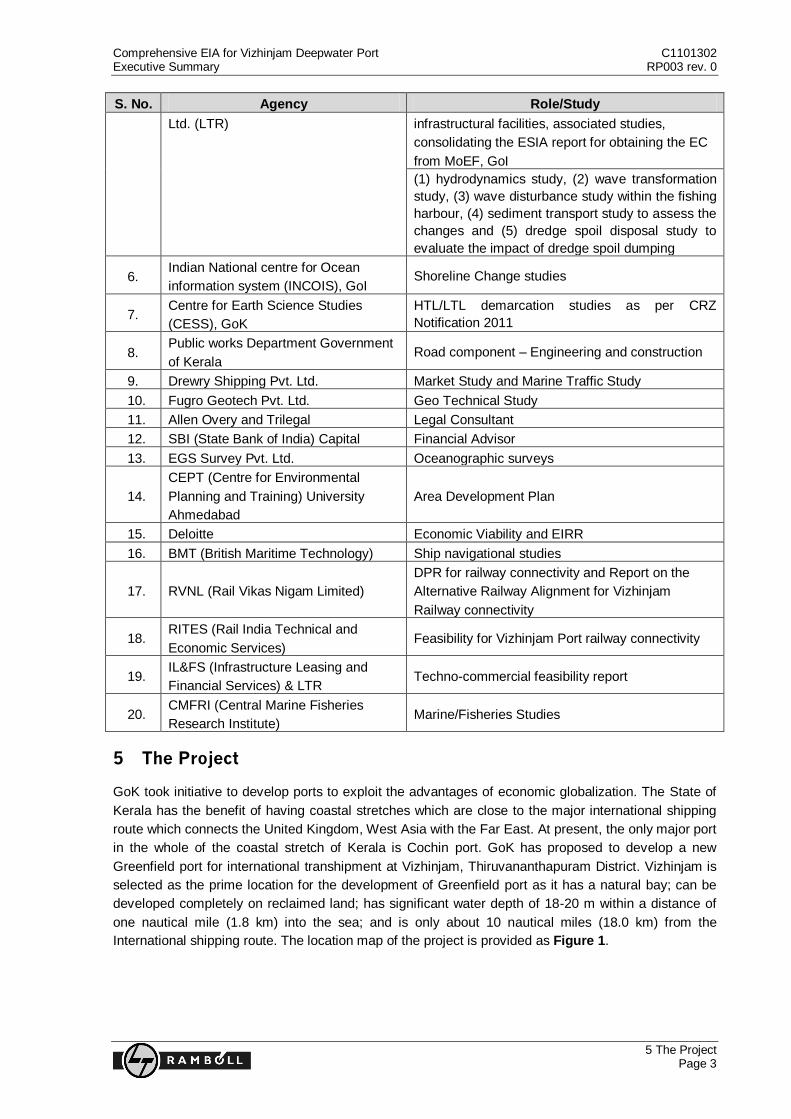
Comprehensive EIA for Vizhinjam Deepwater Port C1101302 Executive Summary RP003 rev. 0
5 The Project Page 3
S. No. Agency Role/Study
Ltd. (LTR) infrastructural facilities, associated studies,
consolidating the ESIA report for obtaining the EC
from MoEF, GoI
(1) hydrodynamics study, (2) wave transformation
study, (3) wave disturbance study within the fishing
harbour, (4) sediment transport study to assess the
changes and (5) dredge spoil disposal study to
evaluate the impact of dredge spoil dumping
6. Indian National centre for Ocean
information system (INCOIS), GoI Shoreline Change studies
7. Centre for Earth Science Studies
(CESS), GoK
HTL/LTL demarcation studies as per CRZ
Notification 2011
8. Public works Department Government
of Kerala Road component – Engineering and construction
9. Drewry Shipping Pvt. Ltd. Market Study and Marine Traffic Study
10. Fugro Geotech Pvt. Ltd. Geo Technical Study
11. Allen Overy and Trilegal Legal Consultant
12. SBI (State Bank of India) Capital Financial Advisor
13. EGS Survey Pvt. Ltd. Oceanographic surveys
14.
CEPT (Centre for Environmental
Planning and Training) University
Ahmedabad
Area Development Plan
15. Deloitte Economic Viability and EIRR
16. BMT (British Maritime Technology) Ship navigational studies
17. RVNL (Rail Vikas Nigam Limited)
DPR for railway connectivity and Report on the
Alternative Railway Alignment for Vizhinjam
Railway connectivity
18. RITES (Rail India Technical and
Economic Services) Feasibility for Vizhinjam Port railway connectivity
19. IL&FS (Infrastructure Leasing and
Financial Services) & LTR Techno-commercial feasibility report
20. CMFRI (Central Marine Fisheries
Research Institute) Marine/Fisheries Studies
5 The Project
GoK took initiative to develop ports to exploit the advantages of economic globalization. The State of
Kerala has the benefit of having coastal stretches which are close to the major international shipping
route which connects the United Kingdom, West Asia with the Far East. At present, the only major port
in the whole of the coastal stretch of Kerala is Cochin port. GoK has proposed to develop a new
Greenfield port for international transhipment at Vizhinjam, Thiruvananthapuram District. Vizhinjam is
selected as the prime location for the development of Greenfield port as it has a natural bay; can be
developed completely on reclaimed land; has significant water depth of 18-20 m within a distance of
one nautical mile (1.8 km) into the sea; and is only about 10 nautical miles (18.0 km) from the
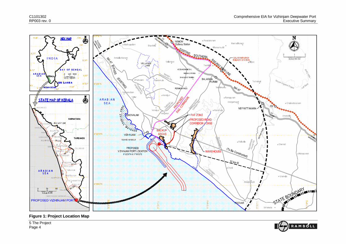
International shipping route. The location map of the project is provided as Figure 1.
C1101302 Comprehensive EIA for Vizhinjam Deepwater Port RP003 rev. 0 Executive Summary
5 The Project Page 4
Figure 1: Project Location Map
Comprehensive EIA for Vizhinjam Deepwater Port C1101302 Executive Summary RP003 rev. 0
5 The Project Page 5
The port will be developed in Landlord Port Model, wherein the GoK will develop infrastructural
facilities like the breakwater, quay walls, dredging, reclamation, utility and connectivity; whereas the
construction and operation of the port terminal would be on Build, Operate and Transfer (BOT) basis
on Public Private Partnership (PPP) model through a concessionaire. The port operations and
superstructure development will be the responsibility of the private operator.
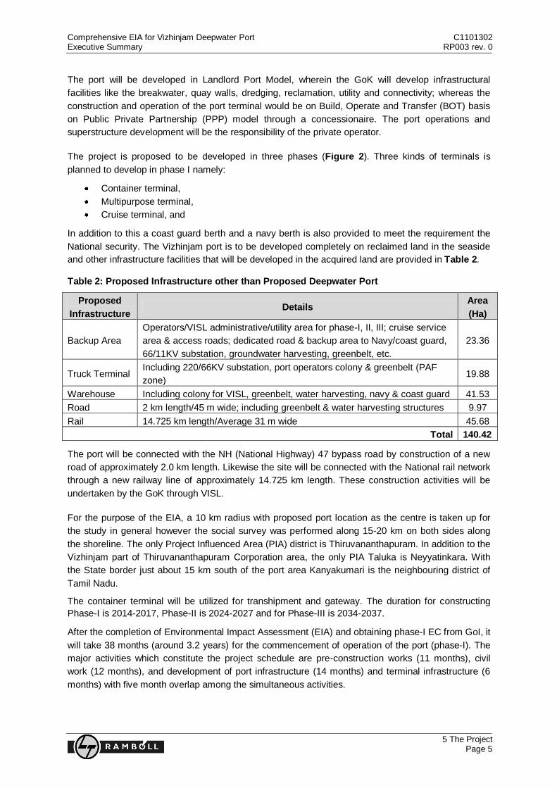
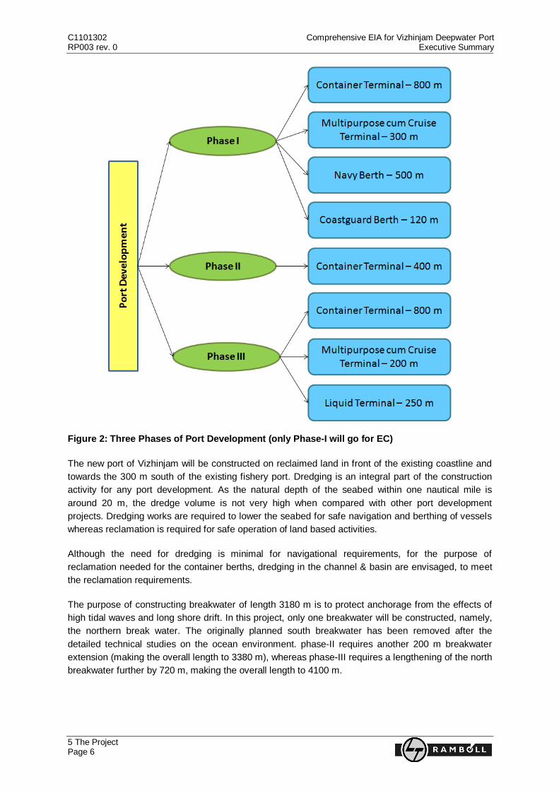
The project is proposed to be developed in three phases (Figure 2). Three kinds of terminals is
planned to develop in phase I namely:
Container terminal,
Multipurpose terminal,
Cruise terminal, and
In addition to this a coast guard berth and a navy berth is also provided to meet the requirement the
National security. The Vizhinjam port is to be developed completely on reclaimed land in the seaside
and other infrastructure facilities that will be developed in the acquired land are provided in Table 2.
Table 2: Proposed Infrastructure other than Proposed Deepwater Port
Proposed
Infrastructure Details
Area
(Ha)
Backup Area
Operators/VISL administrative/utility area for phase-I, II, III; cruise service
area & access roads; dedicated road & backup area to Navy/coast guard,
66/11KV substation, groundwater harvesting, greenbelt, etc.
23.36
Truck Terminal Including 220/66KV substation, port operators colony & greenbelt (PAF
zone) 19.88
Warehouse Including colony for VISL, greenbelt, water harvesting, navy & coast guard 41.53
Road 2 km length/45 m wide; including greenbelt & water harvesting structures 9.97
Rail 14.725 km length/Average 31 m wide 45.68
Total 140.42
The port will be connected with the NH (National Highway) 47 bypass road by construction of a new
road of approximately 2.0 km length. Likewise the site will be connected with the National rail network
through a new railway line of approximately 14.725 km length. These construction activities will be
undertaken by the GoK through VISL.
For the purpose of the EIA, a 10 km radius with proposed port location as the centre is taken up for
the study in general however the social survey was performed along 15-20 km on both sides along
the shoreline. The only Project Influenced Area (PIA) district is Thiruvananthapuram. In addition to the
Vizhinjam part of Thiruvananthapuram Corporation area, the only PIA Taluka is Neyyatinkara. With
the State border just about 15 km south of the port area Kanyakumari is the neighbouring district of
Tamil Nadu.
The container terminal will be utilized for transhipment and gateway. The duration for constructing
Phase-I is 2014-2017, Phase-II is 2024-2027 and for Phase-III is 2034-2037.
After the completion of Environmental Impact Assessment (EIA) and obtaining phase-I EC from GoI, it
will take 38 months (around 3.2 years) for the commencement of operation of the port (phase-I). The
major activities which constitute the project schedule are pre-construction works (11 months), civil
work (12 months), and development of port infrastructure (14 months) and terminal infrastructure (6
months) with five month overlap among the simultaneous activities.
C1101302 Comprehensive EIA for Vizhinjam Deepwater Port RP003 rev. 0 Executive Summary
5 The Project Page 6
Figure 2: Three Phases of Port Development (only Phase-I will go for EC)
The new port of Vizhinjam will be constructed on reclaimed land in front of the existing coastline and
towards the 300 m south of the existing fishery port. Dredging is an integral part of the construction
activity for any port development. As the natural depth of the seabed within one nautical mile is
around 20 m, the dredge volume is not very high when compared with other port development
projects. Dredging works are required to lower the seabed for safe navigation and berthing of vessels
whereas reclamation is required for safe operation of land based activities.
Although the need for dredging is minimal for navigational requirements, for the purpose of
reclamation needed for the container berths, dredging in the channel & basin are envisaged, to meet
the reclamation requirements.
The purpose of constructing breakwater of length 3180 m is to protect anchorage from the effects of
high tidal waves and long shore drift. In this project, only one breakwater will be constructed, namely,
the northern break water. The originally planned south breakwater has been removed after the
detailed technical studies on the ocean environment. phase-II requires another 200 m breakwater
extension (making the overall length to 3380 m), whereas phase-III requires a lengthening of the north
breakwater further by 720 m, making the overall length to 4100 m.
Comprehensive EIA for Vizhinjam Deepwater Port C1101302 Executive Summary RP003 rev. 0
6 Environmental Baseline Page 7
6 Environmental Baseline
The current state of the environment was studied (primarily for bench marking) in the project area and
within a radius of 10 km from the project site (further referred to as the study area). The following
components of the environment were taken into account: land environment, water environment,
marine environment, air environment, noise, biological environment, infrastructure and public
utilities and the quarry site. The outcomes are summarized in this report.
6.1 Land Environment
The study area consists of marine water and land that is partly covered under green coverage: mainly
coconut plantations in between the cultivated land. The coastal area consists of multitude of rock
outcrops/cliffs and few lateritic cliffs intermingled with beach pockets without any eco-sensitive areas
like mangroves or coral reefs. The beaches are plain and devoid of sand dunes. The land behind the
pocket beaches are intermingled with coconut trees and buildings. Behind the shoreline, at about 500
m inward, agricultural land and coconut plantations are present in-between human settlements. The
Vizhinjam fishing harbour, which is a harbour (natural bay) with manmade infrastructures, is located at
the northern side of the project site (at a distance of approximately 300 m). This region is densely
populated predominantly by fishermen communities. To study the soil characteristics of the study
area, five locations were selected from where the soil samples were collected and analysed for
important relevant physico-chemical parameters. The soil fertility was observed to be high in the
Vizhinjam, Nellimudu and Mulloor area and lower in the Nedumam and Karinkulam area.
Construction Material: For the reclamation of the land area for the project site as well as the
construction of breakwater, rocks are required, which will be obtained from quarry sites. Four suitable
quarry locations have been shortlisted for the proposed project based on the distance to the project
site, size of quarry, quality of material and potential for environmental impact (at quarry and via
access/transport routes). They are: Karavaram (Kerala), Kadavila (Kerala), Malayam (Kerala) and
Thakala (Tamil Nadu). In August 2012, VISL confirmed that out of the aforementioned four shortlisted
quarry sites, Kadavila and/or Thottyode brownfield quarries with barge access through Muthalapozhi
and Colachel respectively (to minimise the impact of conveyance through trucks) will be used as
source of the quarry materials. Nevertheless the final selection among the quarries will be carried out
by the contractor. The contractor will be obliged to, among others, consider National/relevant
guidelines for Construction Materials Extraction and the relevant legal framework of India as selection
criteria.
6.2 Water Environment
The major surface water bodies present within the study area are the Karamana River, Neyyar River
and Vellayani Lake. Vellayani Lake is a fresh-water lake, which is the source of water for Vizhinjam
and nearby areas. According to the available project documentation so far water for the proposed
project in the construction and operation phase will also be sourced from this lake. Neyyar River is
along the 10 km distance boundary.
Both surface and groundwater qualities were analysed at six and five representative locations for
three seasons respectively. The surface water samples were taken from the sources used by
communities for domestic or agricultural purpose and were analyzed for a wide range of parameters.
The results indicate that the surface waters were devoid of pollution as for total phenolic compounds,
heavy metals (Lead, Zinc, Chromium, Cadmium, Selenium, Mercury and Arsenic), cyanide, oil &
C1101302 Comprehensive EIA for Vizhinjam Deepwater Port RP003 rev. 0 Executive Summary
6 Environmental Baseline Page 8
grease and free ammonia. The results of groundwater quality analysis for heavy metals like Cadmium,
Selenium, Arsenic, Mercury, Lead, Zinc and Chromium, cyanide, phenolic compounds and Boron, for
all samples, signify that the groundwater is devoid of these kinds of chemical compounds. Total
coliform and E. coli were absent in all the sampled water, which signifies that the water was devoid of
bacteriological/sewage contamination.
Despite the fact that the groundwater table is recharged during the monsoon season (June to
October) the groundwater in Vizhinjam area is being over exploited.
The high population density in the area and an indiscriminate extraction of groundwater for domestic
and agricultural purpose through bore wells and dug wells contributes to water availability related
problems. Selling of water (Water marketing) during summer, especially in the nearby Venganur
Panchayat where it is an established activity, also leads to heavy withdrawal of groundwater. The
groundwater in general, including the water that is used by communities for domestic or agricultural
purposes, is devoid of pollution. The groundwater is thereby devoid of bacteriological (sewage)
contamination as well.
6.3 Marine Environment
The seabed within the project area is gently sloping down in a South-west direction. Water depths
within the survey area range between a minimum of 0.0 m and a maximum of 22.5 m. The Northern
part of the Vizhinjam harbour area has a natural deep bay, whereas the southern side is dominated
by rocky outcrops. At present the Vizhinjam fishing harbour has a total basin area of 16.4 Ha.
The waves approach majorly from two directions: South to South-West and West to South-West.
Waves from the South to South-West direction approach the near shore in May to October, whereas
in the rest of the year the waves come from the West to South-West direction. The highest wave in
the offshore of the proposed project area is of about 4.0 to 5.0 m. Waves of about 1.0 m are most
frequent (around 20% of all waves in a year are between 1.0 m. and 1.25 m).
The predominant current direction is south-east in the period between February and October. The
speed of the current is highest during the monsoon season. The direction of the current is reversed
during the post monsoon period (November to January). There are three different types of seabed in
the project area: Clayey/silty fine sand, fine to medium sand and rock outcrops. The first two types of
sediments are predominant within the study area. The rocky outcrop is predominant near the
shoreline. No other significant seabed features were identified in the project area.
For a safe operation of the harbour and the terminals, the channel for the ships to approach and leave
the harbour, as well as a turning space for the ships, needs to be dredged. That is, sand needs to be
removed to deepen these areas.
The approach channel that needs to be dredged has medium dense to very dense dark grey silty
sand, with occasional shell fragments on the top layer. Towards the deeper side of the borehole the
sediment is more soft and sandy clay/silty/dense in nature. In the turning circle region the sediment is
medium dense to dense clayey sand with shell fragments, and occasionally silty.
Sediment samples from six locations were collected in different seasons and were analysed for
different physico-chemical parameters (heavy metals, etc.). From the results it can be concluded that
the sediment was not contaminated with the parameters analysed for (within the rage of the standard
limits prescribed by USEPA).
Comprehensive EIA for Vizhinjam Deepwater Port C1101302 Executive Summary RP003 rev. 0
6 Environmental Baseline Page 9
Most of the dredged material (approximately 80%) will be used for reclamation. The dredged material
that is not suitable for reclamation will be dumped at two sites (Identified based on silt dispersion
model studies) further offshore, parallel to harbour, at about 2.0 to 4.0 km from the dredging area.
The shoreline is not a fixed line and its position is dynamic. The shoreline changes naturally during
the years because of the suspension of sediment and transportation of the sediment. The latter is
caused by the current during the monsoon season.
If this natural cycle is disturbed by human intervention, an unbalanced sediment transport cycle will
occur, which may lead to an unusual and irreversible shoreline dynamic. Since 1950 the shoreline
erosion problem in the coast of Kerala has been a major issue for the State. Coastal protection
measures were installed to protect the shoreline from significant erosion. Today about 53% of
Kerala‟s coast is artificial. Still the proposed site shows an accretion tendency, pocket beaches show
a medium erosion trend, the north of Vizhinjam also shows erosion tendency and the coast near
Karamana River (Panathura) is eroding heavily as is the case with most of the river mouths which
have dams/sand mining in the river upstream, which disturbs the sediment inflow/balance at the river
mouths.
Marine water samples were collected from six locations in different seasons. Relevant physico-
chemical and biological parameters were analysed for. The seawater in the marine stretch of the
proposed project area can be compared with the Water Quality Standards for Coastal Waters
(Annexure 5 of EIA guidance manual for ports and harbours, MoEF, 2010), be classified under SW1.
As per the surveys conducted by CMFRI, amongst others in 2011 and 2012 it can be concluded that,
although the fish catch in the whole Thiruvananthapuram PIA district is decreasing since 2010, there
are 11 fish landing centres present in the project area, varying from large to small sites. The most fish
is caught at the Vizhinjam harbour and Adimalathura beach landing. The Indian Mackerel, Mackerel
Tuna, Bigeyescad and the Striped Pony fish are caught the most. Apart from fishes, mussels, squids
and crabs are also significantly contributes to the catch. Mussel and lobster landing take place only at
Vizhinjam; crab landing takes place mainly at Puthiathura. The local fisherman use both traditional
and mechanized (outboard engines) fishing methods.
The wadge bank is a fertile fishing ground in the ocean and rich in biodiversity. Because the impacts
of strong currents, waves and tides are rather low this area can build-up a wealth of nutrients and fish
food. Subsequently, the congregation of different fish and other aquatic organisms is significant in the
wadge bank compared to other fishing grounds. It is also a favourable spawning and breeding ground
for fish and other marine animals. Throughout the world there are 20 wadge banks, out of which, one
is situated in the South-West direction from the coastline of the Kanyakumari District, India. This is
about 40 km away from the project site (South Western side). This is also visible in all satellite
imageries and Google imageries as a continental platform. The International shipping route with
several 1000s of ships movements per year is located at about 18 km from Vizhinjam is routed
through this wadge bank. Based on all available data and distance to International shipping route (18
km) and the wadge bank 40 km Vizhinjam deepwater port is safely located. It can be inferred that
endangered species like leatherback turtles, Olive Ridley turtles, Risso dolphins, Devil rays, Green
turtles and Hawksbill turtles are rarely present around the project area. Only rare sighting of Olive
Ridley turtle has been reported near these areas, whereas seasonal and regular nesting ground of
these turtles were not established in the project stretch.
Dredging, dredge material disposal and reclamation: Fill material will also be required apart from
rocks for reclaiming land from sea to develop the port area. In phase-I, most of the fill material will be
C1101302 Comprehensive EIA for Vizhinjam Deepwater Port RP003 rev. 0 Executive Summary
6 Environmental Baseline Page 10
obtained from the dredged material itself. Two marine disposal sites have been identified based on
model studies for the disposal of dredged material, which can neither be used as fill material nor for
landscaping.
6.4 Air Environment
The entire Kerala being a greenbelt, the air quality problem in Kerala is highly ephemeral and
localised in nature and is principally happen due to the occasional absence of wind movements or
circulation. Nevertheless this is not applicable to highly industrialised areas or locations of Kerala
where the problem aggravates during the absence of seasonal wind movements.
Further Kerala is enclosed between the Arabian Sea and the mountain spread over the Western Side
of India, the Western Ghats. This determines the local climate, as the dry winds from the North are
shielded by the mountains and the breeze from the ocean cool the temperature around the coast. The
seasons of Kerala are generally divided into Winter, Summer, SW Monsoon and NE Monsoon.
The mean temperature during these seasons is more or less similar and around 27-28°C. During the
summer and winter a north-east wind is dominant, with stronger winds during the winter period.
During the monsoon season the South-West and North-East wind dominates, which depicts the two
different seasons of monsoon (SW and NE monsoon). Hard winds in the form of cyclones are very
rare in the project area.
The Thiruvananthapuram area is flood prone with the central part of the city at Thampanoor has
always had serious drainage and flooding problems. This also happens several times during the
monsoon. Similar to that in general, flooding is highly localised in nature and the low lying area gets
flooded during the SW monsoon season. During NW monsoon this is a rare occurrence phenomenon.
The air quality monitoring was carried out in nine locations within a 10 km radius. Sampling was
carried out twice a week for 45 days at each location for parameters like dust. SO2, NO2. The levels
measured were below the standards prescribed by NAAQM Standard, 2009. The quality of the air in
the project area is relatively good as it does abide to different (international) norms and standards.
To establish the ambient noise scenario in the study area, monitoring of ambient noise level was
carried out at nine representative locations in the study area using a suitable portable sound level
meter over a period of twenty-four hours, with uniform interval of one hour, in each season. The
results were below the National/relevant general guidelines; mentioning a noise standard of 55 dB(A)
Leq for day time and 45 dB(A) for Leq night time. But the level of noise at different places in the
project area is rather high during the whole year, mainly due to intensive traffic.
6.5 Biological Environment
The study area falls under the coastal area (lowland) of the Thiruvananthapuram district. In this area
various tree and plant species can be found. These species include Veppu, Kasumavu, Plavu, Arayal,
Rubber, Mavu, Njaval, Teak, etc. Shrubs include Bougainvilla, Kallanmula, etc. and herbs include
Adalodakam, Thulasi, Kattavanakku, etc. Local inhabitants use some of these species as medicines,
fodder, food and firewood.
Although there are no forests present in or around the study area a lot of green coverage and
undisturbed natural patches are present and form a habitat for various animals. Important mammals in
the study area are, among others, Dogs, Jackals, Mice, Moles, Porcupines and Mongooses. Most
Comprehensive EIA for Vizhinjam Deepwater Port C1101302 Executive Summary RP003 rev. 0
6 Environmental Baseline Page 11
common reptiles are, among others, Indian Cobra, Indian Chameleon, Python and the Russell Viper.
Most common avifauna is, among others, Black Partridge, Red Vented Bulbul, Baya Weaver and the
endangered Nilgiri wood-pigeon.
No declared eco-sensitive zones like a National Park, a Wildlife Sanctuary or Wetlands are
present within a 10 km radius of the project site.
6.6 Infrastructure and Public Utilities
There are about 5,107,000 people residing in the 10 km study area. The source of water supply is
surface water and groundwater. Several water supply and augmentation schemes are in operation to
provide drinking water to the rural and urban areas at this moment. The existing water schemes are
piped water supply networks that transport water to households, non-domestic connections; industrial
connections and public stand posts. About 28.1% of the people in the study area have piped water
system in their houses. The major source of drinking water is public tap (32.3%), house connection
(41.6%) and others (31.9%) respectively. The areas that are not connected to these pipe networks
depend on either dug wells or bore wells. Most of the areas in the PIA district suffer from acute
shortage of water for domestic use during summer; however, the study area has the highest water
shortage in the district.
The project area lacks a good sewerage system as only the Thiruvananthapuram Municipal
Corporation has a running sewerage system; several other sewerage systems in the area are under
construction. Although based on population density Vizhinjam is also added to the corporation area it
will take many years for the Corporation to extend these kinds of facilities to the Vizhinjam port area.
Open sewage discharges into the sea are a common sight in the project area.
Solid waste is generated mainly by households. Other sources are commercial sources and waste
collected via street sweeping. The Municipal Corporation has established a centralized solid waste
management plant in Vilappilsala, which is situated in the outskirts of the city area and processes the
generated solid wastes only by composting and closed recently due to social issues. Apart from this
plant there is no solid waste management facility in the project area. The Vilappilasala is located
outside the 10 km radius of the study area of the proposed deepwater port. As most households lack
a door to door collection facility or waste bin nearby the house, solid wastes are either openly burned
or dumped in open places.
Apart from several tourism infrastructure (see the tourism section) and facilities other infrastructural
facilities in the PIA district are NHs, SHs (State highways), a railway station, airport, harbours and
various public offices such as a post office, telephone exchanges or cinema houses.
There are two nos. of fishing harbours and various fish landing sites in the coast of PIA district.
Additionally three fishing harbours are under consideration over and above the existing; Vizhinjam
fishing harbour. At the fishing harbour occasional (not regular) dredging is carried out in the basin to
provide safe berthing for cargo ships. Other ships and boats that enter the harbours are canoes and
vessels. The active fisherman in the PIA district is about 5,52,897. (Marine Fisheries Statistics, GoK,
2010). Deep sea fishing is thereby prohibited during the onset of monsoon period for 45 days from
June 15th to July 30
th every year; only near shore is allowed in that period. During monsoon season
people from far way places also operate from the Vizhinjam fishing harbour. In the project core area
except mussel fishing and shoresein fishing on the northern part of the proposed port and immediate
south of the existing fishing harbour no other major activities are visible and noticed. Except few
C1101302 Comprehensive EIA for Vizhinjam Deepwater Port RP003 rev. 0 Executive Summary
7 Socio-Economic Baseline Page 12
residents near the identified back up areas, there are no declared/approved fishing villages in the
shadow area of the proposed deepwater port.
6.7 Quarry Sites
Quarry material is required for the construction of breakwaters. Quarry material can be sourced from
two sites: Kadavila and Theviyodu. The former quarry site is located towards North-West direction
from the project site in Kerala (about 60 km from the proposed port site) whereas the latter is located
towards South-East direction from the project site in Tamil Nadu. The Kadavila quarry site is
surrounded by thick vegetation comprising both of natural trees as well as rubber/coconut plantations.
The plantations are intermingled with human settlements, on both sides of the roadway that is
proposed to be used for the transportation of quarry materials. The quarry material from Kadavila is
planned to be transported to Muthalapozhy harbour through Kallambalam and Kadakavur Junction.
From Muthalapozhy harbour, the quarry material will be transported on barges to the project site.
The surroundings around the Theviyodu quarry area are sparsely vegetated with trees such as
Coconut, Amla and Neem. Only a few mud houses of workers working in the quarry are present near
the quarry area. Similar to the Kadavila quarry site, the quarry material will be transported through
roadway and sea. The quarry will be brought from the Theviyodu to Colachel port, via Thottiyoodu
and Monday market junction, from where it will be shipped in barges to the project site (total 55 km).
7 Socio-Economic Baseline
7.1 General Setting and Study Area
The project stretch, which is the footprint of the project layout, falls under the Thiruvananthapuram
Municipal Corporation and Neyyattinkara Taluk, in PIA district. The study area for the socio-economic
baseline description consists of 10 km radius around the project stretch and also coastal villages
present between 25 km to 15 km distance from the project stretch in the Northern and Southern
directions, respectively.
7.2 Social Survey
Socio-economic data pertaining to the study area (10 km radial distance from the project stretch) were
not available. To collect study area specific socio-economic profile, a door to door social survey of
about 5900 households was conducted from April to June 2012. Totally, 43 Focus Group Discussions
(FGDs) were conducted in the aforementioned period to create public awareness about the project
and to understand the apprehension of the local people. Especially Project Affected People (PAP) i.e.
fishermen and people involved in tourism related activities in the shadow area of the project, have
been involved.
28 FGDs for fishermen population were conducted in 22 coastal villages (located between 25 km to
15 km distance from the project stretch dotted with fishermen settlements in the Northern and
Southern directions, respectively). Another primary goal for these FGDs was to understand the use of
the project stretch as well as Vizhinjam fishing harbour by the fishermen (beyond 10 km region) and
also by people involved in other economic activities, like tourism and beach-related activities in the
study area.
The remaining 15 FGDs and other consultations were conducted related to tourism and other allied
activities. 15 FGDs for people involved in tourism and its allied sector were conducted in nine resorts
Comprehensive EIA for Vizhinjam Deepwater Port C1101302 Executive Summary RP003 rev. 0
7 Socio-Economic Baseline Page 13
and in Kovalam, which is a world renowned tourist place located about 2.0 km towards the North West
from the North of the project site. A separate structured questionnaire has been prepared and
circulated among the 31 resorts/hotels located in the shadow area of the project to collect project site
specific tourism data. Information was received from nine resorts only.
In addition to this, two more FGDs were conducted in and around the Kadavila and Theviyodu quarry
locations.
7.3 Population Profile
Total population count in the surveyed study area was 440,180 (Census of India, 2001, primary data
collected from administrative offices like Panchayat, Municipality, etc.). Out of this total number of
people, 25,850 people (total household count was 5,871) were covered in the social survey carried
out for this project. Out of the total number of surveyed households, 3,167 households were from
Zone 11 (0-2 km from project site), of which 2,112 fishermen households. A total of 8,159 people were
surveyed in Zone 2 (2-5 km from project site), which constitutes 2,023 households. Out of these, 262
households belonged to the fishermen community. Similarly, 681 households were covered in Zone 3
(5-10 km from project site), which included 2,669 people residing in this zone. Out of these, only 12
households belonged to the fishermen community.
The surveyed households had an average of 4.2 members. In the surveyed settlements, about 53%
of respondents were from rural areas, 29% were from semi-urban and the rest (18%) were from urban
areas. The surveyed area was a medium (42.3%) to high (53.4%) densely populated region. The
average gender ratio of the surveyed population was 935 (Male: Female).
It can be inferred from the survey that Zone 1 has a relatively high percentage of people <18 years old
and 18 to 35 years old, when compared to Zone 2 and 3. Furthermore, in the study area the majority
(70%) of the total surveyed respondents came under the Other Backward Caste (OBC). Whereas,
Schedule Caste and Schedule Tribe accounted for 9.0% and 2.5%, respectively of the total surveyed
households.
In the study area 77.16% of the people were literate, which is lower than the average literacy rate of
the State (93.91%) and PIA District (92.66%) for the year 2011 (Official Web Portal of GoK)).
Moreover, Christianity, Islamism and Hinduism are the three major religions prevalent in the study
area.
7.4 Economic Activities
As the project site is located in the coastal region, the main occupation of the local people is fishing
and fishing-related activities. Apart from fishing, tourism and agriculture are also important economic
activities in the study area. There were no major industries in the study area. A small percentage of
people were depended on services mainly in the Government sectors, educational institution or other
commercial establishment of the area.
From the local surveys carried out it can be concluded that the majority of people in Zone 1 (67%)
were occupied in fishing (including mussel and lobster collection) and its allied activities. In Zone 2
and 3 most people (about 58% and >95%, respectively) were self-employed or employed in the
private/public sectors, or were working in the Gulf countries. Agriculture forms another major sector of
occupation in Zone 2 about 28% of the surveyed respondents were farmers/farm owners. In the study
1 Zone 1 is 2.0 km radii, Zone 2 is 5.0 km radii and Zone 3 is 5-10 km radii; identified for fisheries survey
C1101302 Comprehensive EIA for Vizhinjam Deepwater Port RP003 rev. 0 Executive Summary
7 Socio-Economic Baseline Page 14
area >75% of the surveyed respondents had average income of less than ` 10,000. The average
monthly income for Zone 1, 2 and 3 was ` 5121, ` 5837 and ` 7207, respectively. In the study area,
the major expenditure was on food, followed by expenditure on „other category’ constituted by fuel,
festival, marriage, loan repayment, etc.
7.5 Fishing and Fishermen Villages
Out of 26 surveyed villages in the study area large proportion of population was found directly or
indirectly involved in fishing or fishing related activities except in villages of Kanjirakulam, Athinoor,
Thirupuram, Kalliyoor, Pallichal, Peringamala, Kottukal and Thiruvananthapuram municipal area. Only
13 villages in the coastal stretch of the study area are officially registered as fishermen villages,
(Marine Fisheries Census, Kerala Part 2, 2010), they are Poonthura, Panathura, Kovalam, Vizhinjam
North, Vizhinjam South, Chowara, Adimalathura, Pulluvila, Pallom, Puthiyathura, Kochuthura,
Karumkulam and Poovar. Out of which, Adimalathura and Chowara are located towards the southern
end of the project stretch. 55,677 fishermen were residing in these 13 designated fisherman villages
(Marine Fisheries Census 2010).
Since, the shore of Nellikunnu, Mulloor, Pulinkudy and Azhimala are aligned with resorts/hotels, the
fishermen settlements of this stretch were found to be in a scattered manner about two to three
kilometres towards the landward side from the shoreline. It is inferred that most of the isolated
fisherman must have sold their coast lands for the tourism and moved interior. This is particularly true
when some individuals hold large chunks of land preparing to construct resorts.
Indian mackerel (26.9%), Bullet Tuna (20.6%), Brown mussels (9.2%) and Indian oil Sardines (7.6%)
constituted to the major portion of the catch, which comprises about 58 different species in the project
area2. The average fish catch was lower for fishermen in Zone 2 compared to fishermen in Zone 1. In
Zone 1, approximately 40% of the fishermen respondents had a pre-monsoon catch between 501-
1000 kg/month, while during the monsoon season only 32% reached this level of catch. In Zone 2,
approximately 40% reported a catch between 251-500 kg/month, in the pre-monsoon season. During
the monsoon season the majority (73%) has a catch of 0 – 100 kg/month. –In other seasons except
the monsoon, most fishermen (>80%) in Zone 1 and 2 use the beaches to land their catch. During the
monsoon season however, fishermen in Zone 1 predominantly use the existing Vizhinjam fishing
harbour (70%), while the majority (60%) of the fishermen in Zone 2 use the beaches for landing their
catch.
7.6 Tourism
Kerala‟s Tourism industry is one of the State‟s significant revenue generating sector. The total
revenue generated in 2011 through the Tourism industry (including direct and indirect means) was `
19,037 Crore, out of which ` 4,222 Crore (around 22%) was earned through foreign exchange (Kerala
Tourism Statistics, 2010). Total tourism revenue increased significantly in 2011 compared to 2010 (by
9.74%). Thiruvananthapuram the only PIA District, in which the project area is located, was visited by
15% of the tourists who visited Kerala in 2011. Kovalam, a world renowned tourist destination, is
located about 2.0 km (boundary to boundary nearest distance) in NW direction from the proposed
project stretch. The project shadow area, which encompasses Nellikunnu, Mulloor, Pulinkudi,
Azhimala, Chowara and Adimalathura beaches has many tourist establishments, mainly based on
2 As per the catch statistics of Vizhinjam fishing harbor and Adimalathura fish landing centers

Comprehensive EIA for Vizhinjam Deepwater Port C1101302 Executive Summary RP003 rev. 0
7 Socio-Economic Baseline Page 15
Ayurvedic tourism. In these, the Chowara and Adimalathura beaches are located in the shadow zone
of the approach channel of the proposed port where no physical infrastructure is envisaged.
During the social survey, it was established that up to 31 resorts were present at the project stretch
including the approach channel, i.e., Nellikunnu to Adimalathura. Only eleven resorts will be impacted
directly; out of this only three are bigger size with more than ten rooms. From the eleven resorts, three
are currently in possession of VISL. About 30% of these resorts were represented through the Focus
Group Discussions. Such FGDs included owners, employees, visitors and travel agents. In addition to
this, specific information about each individual resort was collected through a separate questionnaire
which was circulated to these resorts. Out of 31 questionnaires only nine with details were regained.
The data collected on the resorts also includes the information received from Kerala Hotel &
Restaurant Association and Pulinkudy ward of Kottukal Gramapanchayat. The details about revenues
generated in these resorts, information on tourist inflow, tourist season, employees and implication of
Coastal Regulation Zone (CRZ) on these Resort/Hotels in the shadow area of the proposed project is
also analysed and presented.
7.7 Stakeholder Consultations
Stakeholder meetings have been conducted since the scoping stage of this EIA study. The
stakeholders, who were consulted during the meetings, were the local people including fishermen,
people involved in tourism, local religious leaders, biologists, researchers, etc., Government officials,
NGOs, etc. Meetings were also carried out for rail and road corridors and also for backup areas.
43 FGDs were also conducted apart from several formal and informal stakeholder meetings relating to
Rail and road terminal EIA studies. During these meetings people seemed to be partially supportive
and partially against the project. Efforts were made to provide clarification on the questions raised by
the public and to provide information about the impacts of the project, both positive and negative.
The following concerns were raised by the people:
Generation of noise and air pollution, which will alter the calm and aesthetic nature of the region;
Marine ecological imbalance due to project execution;
Both direct and indirect loss of employment in the fishing communities;
Decrease in employment opportunity in the tourism sector;
Invasion of new diseases and pests in the area; and
Possibility of change in the wave and current patterns leading to increase in soil
erosion/accretion, thereby change in existing coastline.
The benefits of the project as perceived by the local surveyed residents were as follows:
An opportunity to develop the area and improve the quality of life of local people;
Agricultural development through better irrigational facilities;
Better infrastructural development, including transportation and improved accessibility through
roads and railways;
Increase in the value of property;
Better employment opportunities;
Development of small scale industries; and
Overall development of the local economy and communication system.
The surveyed residents also felt that the project developer should contribute to the community
development and suggested the following:
C1101302 Comprehensive EIA for Vizhinjam Deepwater Port RP003 rev. 0 Executive Summary
8 Environmental Impacts and Mitigation/Avoidance Measures Page 16
Infrastructure to be improved - drinking water, sanitation, sewerage, better drainage system and
solid waste management, road and street light facilities, widening of pavements, under pass
shopping facility, clubs, park/playground, auditorium, better postal services, banking facilities,
better electricity supply, transformer, etc;
Health facilities – local communities are in need of good government hospital, veterinary hospital,
mosquito control;
Educational facilities also need attention;
Job opportunities need to be created;
New fishing harbour and fish marketing area need to be considered;
Better transport facilities could be developed under the project - passenger trains, bridge, bus
services with proper facilities, car parking.
Tourism – this sector needs new infrastructure for tourists and development of tourist townships.
Additional consultations: In addition to the above consultations several other formal and informal
consultation were also held for road/rail connectivity and other ancillary sites EIA studies. As a part of
overall project development Social Impact Assessment (SIA) and Resettlement Action plan (RAP) is
also prepared.
8 Environmental Impacts and Mitigation/Avoidance Measures
The identification and assessment of potential environmental impacts is at the core aspects of any
EIA. The EIA focuses on activities during the construction and operation/maintenance phases of the
project.
8.1 Identification of Potential Impact Categories
8.1.1 Potential Impacts
Activities during the port construction phase include construction of breakwaters, terminals and labour
camps, dredging and reclamation, disposal of dredged material into marine disposal area, and
quarrying (including transportation of quarry materials). Activities during the port operation and
maintenance phase include the operation and maintenance of container terminals, multi-purpose
terminals and cruise terminals. Activities during the port decommissioning phase are all about
decommissioning all installations and infrastructure.
The following potential impact categories are taken into account:
Land Environment Flora and Fauna
Water Environment Marine Ecology
Marine Environment Raw Materials
Air Environment Visual Amenities
Noise Pollution Occupational Health and Safety
Climate Change Community Health and Safety
Solid Waste Management
Below the interactions between the project phases related activities and the impact categories are
discussed.
8.1.2 Impact Mitigation and Avoidance Measures
For each of the identified impacts specific mitigation measures were defined in terms of avoidance or
reduction of negative impacts, repair of damage or compensation for irreversible loss. Below
Comprehensive EIA for Vizhinjam Deepwater Port C1101302 Executive Summary RP003 rev. 0
8 Environmental Impacts and Mitigation/Avoidance Measures Page 17
mitigation measures are subsequently defined for impacts on the land environment, water
environment, marine environment, air environment, noise, climate change, solid waste management,
biological environment, raw material use, visual amenities, occupational health and safety and
community health and safety. For many categories different environmental management plans are
described as proper mitigation measures.
Analysis of Alternatives & Avoidance: Avoidance (just avoid major potential impact) being the best
mitigation measure several site alternatives, location alternatives and engineering alternatives were
studied in detail to finalise various aspects of the project. By doing these alternatives several impacts
were avoided along rail, road and port location. The site alternatives questioned by tourism
community has been reworked and unequivocally established the importance of the Vizhinjam site
selection. All stakeholder representations were very useful and helped VISL/GoK and the consultants
to see things realistically and worked out all possible mitigation measures to compensate, reduce,
minimise the possible and probable impacts. GoK has endorsed the fact that due to this project
construction and operation all PAPs should at least live with the same standard of living if not a better
standard. In other words no PAPs should suffer due to this important National project that is being
implemented by the State Government.
8.2 Land Environment
8.2.1 Impacts
Construction Phase: Due to the construction of the port and all other associated infrastructure (rail
and road, Truck parking area, Residential area and the warehouse area) the local landscape will
positively change for better, with a different and denser spatial organization of buildings, installations,
tanks and infrastructure on the reclaimed area and backup area. The area will be developed in a far
more industrial manner compared to the current situation. The increased activities in the area will
disturb and disperse the (top) soil. The soil will thereby suffer an increased vulnerability for
contamination via spills and leakages as well. Furthermore, an improper construction might hamper
proper water runoff, flooding and local ponding with potential undesired and even unsafe
consequences. Also, the coastline will change due to the reclamation. Area has been modelled; this
change will induce increased accretion to the South but will stabilise after certain period of time. But
no significant change in the shoreline pattern was observed towards northern side.
Operational Phase: This situation will continue in the operational phase due to the port activities.
8.2.2 Mitigation and Avoidance Measures
Construction Phase: Monitoring of changes related to the land environment is important and
therefore a Monitoring Plan has been prepared. A proper drainage system should be realised to
prevent water problems and associated consequences for the land environment. Where ever possible
top fertile soil shall be collected and stock piled to spread it on the top surface for landscaping after
construction work is completed. An area development plan is thereby important as well, including
landscaping to improve the aesthetics after the construction activities are finished. Contractors should
be prepared and responsive to possible tsunamis. Sewage and wastes (incl. domestic, construction
and ship wastes) should be collected and treated properly and according to National and international
guidelines. Contingency plans need to be drafted and executed by the contractors, including spill
prevention and control procedures.
C1101302 Comprehensive EIA for Vizhinjam Deepwater Port RP003 rev. 0 Executive Summary
8 Environmental Impacts and Mitigation/Avoidance Measures Page 18
Quarry Sites: A Land Reinstatement Plan/Rehabilitation Plan (part of contractors EMP) and for
quarry areas should ensure that the land environment is restored in a proper manner, via for instance
active reforestation and the planting of vegetation to prevent erosion (quarry sites will be developed
as greenbelts after finishing the works). All aspects of quarry operation will be documented (e.g.
agreement with land owner of the quarry in case of a new quarry)
Operational Phase: Port sewage and wastes (including ship wastes) should be collected and treated
properly according to National and International guidelines (Waste Management Plan/Emergency
Contingency Plan need to be drafted including spill prevention and control procedures where the role
of communities and community infrastructure is taken into account). Port operators should be
prepared and responsive to possible tsunamis. Over the whole area being nearer to Kovalam a tourist
grade quality need to be maintained in all areas of the project. For the purpose of the operational
EMP and decentralised environmental management, ten such land use zones have been delineated
and provided in the EMP. All operation environmental management aspects of these units will be
treated separately. Except during the first phase of operation, VISL is to develop all such facilities and
institutional strength to carry out all EMP implementation through a full-fledged EMP cell.
8.3 Water Environment
8.3.1 Impacts
Construction Phase: The area already suffers from acute water shortages and the new proposed
construction activities will further could impoverish the water availability in the region if not managed
properly. The port construction might (partly) block natural water outlets and drains. Ponds and
flooding in and behind the port area, a changed local drainage pattern, higher groundwater levels and
potential water contamination due to the piling up of sewage discharges in the drain ponds might be
the consequences. The groundwater quality could be affected by spills or leakages, or a poor waste
handling in the area, especially from labour camps.
With very high rainfall the project area is flood prone and the area could be flooded (localised
flooding) during monsoon season.
Operational Phase: The water availability could be a problem in the operation phase due to a higher
water demand. If not taken care of properly in the design and construction phase the drainage
situation and with that also the groundwater situation will be a continuous negative aspect during the
operation phase as described above. Moreover, the terminals for liquid bulk and the operational
activities related to liquids and to some extent solid waste could impact the groundwater negatively.
8.3.2 Mitigation and Avoidance Measures
Construction Phase: To prevent the occurrence of flooding and undesired and unplanned discharge
of (polluted) water sufficient structures for adequate drainage should be installed. The new port
design has taken into account the undesired and unsafe flooding with proper drainage design
provisions. The natural outlets should be properly rerouted and surface run-off should be managed
via interception channels, earth bunds, etc. In addition proper arrangements should be in place to
ensure that adequate surface protection measures can be safely carried out well before rainstorms.
Emergency management plans, spill prevention and control plans (by contractors) and adequate
facilities with emergency shutdown possibilities for processes with hazardous materials (such as
fuels) are important mitigation measures as well. Waste waters should be recycled as far as possible,
keeping discharge at a minimum. Other wastes should be handled according to a contractor waste
Comprehensive EIA for Vizhinjam Deepwater Port C1101302 Executive Summary RP003 rev. 0
8 Environmental Impacts and Mitigation/Avoidance Measures Page 19
management plan, encompassing proper sanitation facilities, sewage treatment plants, collection and
disposal mechanisms and ship wastes management options.
Operational Phase: A Water Management Plan should safeguard a sustainable water balance in the
region, whereby water use is limited via, for instance, recirculation or the provision of alternative
sources for water consumption. This water management plan also recommends for a detailed
reassessment of all possible water resources within a ten km radius of the project area. This requires
geological and hydro geological mapping including structural and linear mapping due to the peculiar
nature of the study area where in hard rock areas are intermingled with recent formations.
Recommendations of the study will be implemented through various line department/institutions
(groundwater department, CWRDM, etc.) of GoK. Monitoring of water quality and quantity is thereby
important and should be executed according to a water monitoring programme. Emergency
management plans, spill prevention and control plans (by the port operators) and adequate facilities
with emergency shutdown possibilities for processes with hazardous materials (such as fuels) are
important mitigation measures as well. Waste waters should be recycled as far as possible, keeping
discharge at a minimum. Other wastes should be handled according to a Waste Management Plan,
encompassing proper sanitation facilities, sewage treatment plants, collection and disposal
mechanisms and ship wastes management options. Rain water harvesting and where ever possible
artificial recharge also will be practiced in all the land ward side facilities. This could be a better option
and necessary budgeting has been provided.
8.4 Marine Environment
8.4.1 Impacts
Construction Phase: Due to the construction of the breakwaters the current and wave power in the
fishing harbour will decrease leading to a more tranquil harbour. The sediments can get contaminated
due to spills and leakages of oil and chemicals, wastewater overflows, waste from ships and
windblown dust during construction. The sediments can be re-suspended and dispersed due to the
construction activities.
Operational Phase: Due to the breakwaters the current and wave power in the fishing harbour will
decrease which leads to a more tranquil harbour. When onshore water outlets discharge wastewater
in the harbour, where the water is sheltered by the breakwater and cannot flow easily in and out, the
water quality will decrease and the marine environment will suffer from this impoverishment of
sediment quality in the breakwater area. The sediments can get contaminated due to spills and
leakages of oils and chemicals, wastewater overflows, waste from ships and windblown dust. The
sediments can be re-suspended and dispersed due to the harbour activities and maintenance
dredging activities.
8.4.2 Mitigation and Avoidance Measures
Construction Phase: Most of the mitigation measures mentioned above apply here as well. In
addition an Oil Spill Contingency Plan should be obligatory for the contractors. The port design should
take a proper discharge of sewage water and sediments seriously into account, to prevent pollution of
the marine basin, especially in the breakwater area. Furthermore, turbidity during dredging should be
kept to a minimum to prevent dredged materials to be transported away from the designated marine
dredge area. Last but not least the construction activities should be organized and communicated with
environmental care, such as: only store fuels/chemicals if needed and away from drainage systems
and the shoreline, handle and store the fuels/chemicals in an impermeable base with a bund and
C1101302 Comprehensive EIA for Vizhinjam Deepwater Port RP003 rev. 0 Executive Summary
8 Environmental Impacts and Mitigation/Avoidance Measures Page 20
sufficient temporary storage capacity, comply with good operational practices, abide to rules and the
international marine conventions, follow standard operational procedures, handle and store
hazardous materials away from active traffic, ensure proper labelling and marking of all handled
materials, set-up and execute routine maintenance and testing procedures, raise awareness among
workers and key stakeholders for environmental care procedures, etc. Proper planning of the
construction activities should prevent possible negative flood impacts. The work plans should
therefore incorporate a section on the prevention of flooding. The contractors EMP should have a
detailed Dredge management plan and Oil spill contingency plan duly approved by the VISL with
systematic dredging and reclamation procedure without affecting the turbidity level in the nearby
waters. For dredging a Dredge and Dredge Disposal EHS Management Plan together with a Dredge
and Dredge Disposal Monitor Programme will be executed.
Operational Phase: Most mitigation measures mentioned above apply here as well. In addition an
Operational Oil Spill Contingency Plan should be obligatory for the port operators. The port design
should take a proper discharge of sewage water and sediments seriously into account, to prevent
pollution of the marine basin, especially in the breakwater area. Furthermore, turbidity during dredging
should be kept to a minimum to prevent dredged materials to be transported away from the
designated marine dredge area. Last but not least, the port activities should be organized and
communicated with environmental care, such as: only store fuels/chemicals if needed and away from
drainage systems and the shoreline, handle and store the fuels/chemicals in an impermeable base
with a bund and sufficient temporary storage capacity, comply with good operational practices, abide
to rules and the international marine conventions, follow standard operational procedures, handle and
store hazardous materials away from active traffic, ensure proper labelling and marking of all handled
materials, set-up and execute routine maintenance and testing procedures, raise awareness among
workers and key stakeholders for environmental care procedures, etc. Proper planning of the
maintenance activities should prevent possible negative environmental impacts. The Emergency Plan
to be prepared by the contractor should incorporate a section on the prevention of and dealing with
localised drainage/flooding issues during monsoon season.
For dredging a Dredge and Dredge Disposal EHS Management Plan together with a Dredge and
Dredge Disposal Monitor Programme will be executed.
8.5 Air Environment
8.5.1 Impacts
Construction Phase: Due to the construction activities in the project area, dust generated from traffic
on unpaved roads, losses of material from construction traffic carrying aggregates and air pollutants
from combustion engines emitted, will negatively impact the air quality.
Operational Phase: Air emissions are generated by machineries, engines and boilers in ships and
land vehicles, storage and handling of bulk (cargo) and movements on sandy undergrounds (dust).
8.5.2 Mitigation and Avoidance Measures
Construction Phase: Dust suspension techniques (no open storage, wetting of sand via sprinkler
systems, blasting at quarry areas only at calm weather conditions, etc.), handling dusty materials with
environmental care (for instance no unloading from great heights) and smart traffic patterns and
management (including speed reduction) should mitigate major emissions of dust and other air
polluting particles. Only allowing vehicles and machinery with low emission profiles, promoting the use
Comprehensive EIA for Vizhinjam Deepwater Port C1101302 Executive Summary RP003 rev. 0
8 Environmental Impacts and Mitigation/Avoidance Measures Page 21
of good quality fuel and lubricants, maintaining and servicing vehicles and machinery regularly and
properly, and the use of heavy generators and combustion plants only at times when lacking
alternatives (during power cuts), control unnecessary polluting air emission further. Restraining
dredging and reclamation during the monsoon seasons is also an important and effective measure.
As are solid barriers or wind screens around construction sites avoid impacts on neighbouring
communities. All measures and their effects should be included in an air quality monitoring
programme, which is specifically relevant during dust generating activities. Volatile spills and leakages
should be detected via leak detection systems and monitoring programmes. Last but not least, air
quality management procedures should ensure great environmental care.
Operation Phase: Only allowing vehicles and machinery with low emission profiles, promoting the
use of good quality fuel and lubricants, maintaining and servicing vehicles and machinery regularly
and properly, and the use of heavy generators and combustion plants only at times when lacking
alternatives (during power cuts), control unnecessary polluting air emission further. Restraining
dredging during the monsoon seasons is also an important and effective measure. All measures and
their effects should be included in an air quality monitoring programme, which is specifically relevant
during dust generating maintenance activities. Volatile spills and leakages should be detected via leak
detection systems and monitoring programmes. Last but not least air quality management procedures
should ensure great environmental care, taking into account, for instance, port access navigation at
partial power by ships or only achieving full power after leaving the port area. In addition the docked
ships are to use „cold ironing‟, a method to connect to external power after switching of the engine
operated by bunker fuel. Also, use of electric cranes in the yard for cargo handling will reduce the
emissions as compared to diesel driven cranes.
8.6 Noise and Vibration
8.6.1 Impacts
Construction Phase: The construction equipment‟s, machinery, installations, etc. will emit noise. The
exact noise levels depend on the location, duration, source and atmospheric conditions such as wind.
Nevertheless the noise levels are expected to be high. Noise and related vibrations potentially cause
nuisance to local populations, local fauna and marine mammals (vibrations can be transported
underwater to considerable distances, depending on the current patterns and strength). It will be clear
that the closest settlements as Vizhinjam fishing village, Mulloor and Pulinkudi and nearby resorts will
potentially be impacted most.
Operational Phase: The operation equipment‟s, machinery, installations, etc. will emit noise. The
noise levels depend on the location, duration, source and atmospheric conditions such as wind and
are expected to be on the higher side. Nevertheless the noise levels are expected to be high. Use of
electric RTGs, which will be used for Vizhinjam port, will produce less noise than the diesel RTGs.
Noise and related vibrations potentially cause nuisance to local populations, local fauna and marine
mammals. During the operation and maintenance phase of the port underwater noises will be emitted
(mainly by ships and maintenance dredging) but these are expected to be insignificant. It will be clear
that the closest settlements as Mulloor and Pulinkudi and nearby resorts will potentially be impacted
most.
8.6.2 Mitigation and Avoidance Measures
Construction Phase: A noise monitoring programme should be set-up and implemented. A change
management process should thereby be applied to modify construction activities, if necessary, to
C1101302 Comprehensive EIA for Vizhinjam Deepwater Port RP003 rev. 0 Executive Summary
8 Environmental Impacts and Mitigation/Avoidance Measures Page 22
address noise issues. Noise and vibration mitigation measures, including equipment on all
installations, machineries, plants, etc., should be installed prior to any construction activity. All
contractors and subcontractors should comply with the relevant National/international noise
standards. Activities that take place near residential or sensitive receptors will be carefully planned
(restricted to daytime, taking into account weather conditions, outside sensitive season for marine
species, etc.) and indicated on clear signs.
Residents in the vicinity are to be notified about construction schedules and activities. Vehicles and
machinery should be maintained and serviced regularly and properly. Workforce working in noisy
environment will be made to wear proper safety gear (PPE - Personnel Protective Equipments) to
avoid any adverse impact of noise on them.
Operational Phase: A noise monitoring programme should be set-up and implemented. A change
management process should thereby be applied to modify operations, if necessary, to address noise
issues. Noise and vibration mitigation measures, including equipment on all installations, machineries,
plants etc., should be installed prior to any operational activity. All port users and maintenance
contractors should comply with the relevant international noise standards. Activities that take place
near residential or sensitive receptors will be careful planned (restricted to daytime, taking into
account weather conditions, outside sensitive season for marine species, etc.) and indicated on clear
signs.
Residents in the vicinity are to be notified about operational schedules and activities. Vehicles and
machinery should be maintained and serviced regularly and properly. Employees working in noisy
environment will be made to wear proper PPE (ear muffs/ear plugs) to avoid any adverse impact of
noise on them.
8.7 Climate Change Vulnerability
8.7.1 Impacts
Construction Phase: These emissions are generated by the import and consumption of fuels and
electricity that are used for, for instance, construction vehicles (trucks, cranes, dredging equipment,
quarrying equipment, etc.), heating, ventilation and air conditioning, energy conversion and energy
distribution systems. During construction these emissions will be limited in time. During construction
phase poor institutional capability and project management capability could lead to poor
environmental performances. Poor contractor selection, unrealistic timeframes and unplanned
procedures, etc. will help to increase emissions of all kinds and due time and cost over runs.
Operational Phase: Greenhouse gas emissions into the atmosphere contribute to climate change.
These emissions are generated by various port activities like the handling and consumption of fuels
and electricity used for transport equipment (trucks, cranes), maintenance dredging, heating,
ventilation and air conditioning, energy conversion and energy distribution systems. Increased climate
changes increase the local vulnerability to extreme weather events (such as storms) and sea level
rise.
During Operational phase also poor institutional capability and project management capability could
lead to poor environmental performances. Unrealistic time frames and unplanned procedures etc will
lead to increased emissions of all kinds and due time and cost over runs. Consumption of all
resources (water, electricity, paper, plastics, etc.) within the port shall be controlled and shall be of
Comprehensive EIA for Vizhinjam Deepwater Port C1101302 Executive Summary RP003 rev. 0
8 Environmental Impacts and Mitigation/Avoidance Measures Page 23
highest efficient with regards to environmental performances achieved by close environmental
monitoring of all port activities.
8.7.2 Mitigation and Avoidance Measures
Construction Phase: The most significant contribution to climate change, air pollution, is mitigated
according to the measures as described above. All these are part of good project management and
construction management and therefore good Environment management with a highly committed
Environmental management team of VISL.
The most significant contribution to climate change, air pollution, is mitigated according to the
measures as described above sections. No direct mitigation measures are possible to implement to
avoid or mitigate the increased exposure to sea level rise and the possibility of more intense storms in
the long run.
During construction phase good institutional capability and project management capability could lead
to excellent environmental performances. Realistic time frames and planned procedures etc will help
to increase emissions of all kinds and to avoid due time and cost over runs. All these can be
addressed by the proper procumbent of the qualified and experienced contractors with proven skill
and abilities for implementing large scale projects. VISL need to include clauses and conditions to
ensure all subcontractors and suppliers are in line with all required Environmental Standards. This is
to avoid subcontractor‟s spoiling the entire construction scenario.
No direct operational mitigation measures are possible to implement to avoid or mitigate the increased
exposure to sea level rise and the possibility of more intense storms in the long run. However, the
entire port with all facilities should be designed to cover for negative impacts related to climate
change. Moreover, all equipments and installations machineries and vehicles shall be procured with
highest environmental standards. The contractors and sub contractors could be selected based upon
his proven environmental performance. The contractors shall be allowed to subcontract only after
ensuring the minimum environmental standards, regulatory compliances labour law compliances, etc.
Operational Phase: The most significant contribution to climate change, air pollution, is mitigated
according to the measures as described above.
Application of all latest environmental friendly technologies, green building concepts and increased
generation and use of alternate sources of energy such as wind and solar and also increased rain
water harvesting etc could help in a very big way to achieve low carbon footprint. Implementation of
these is important to achieve the green port standards for Vizhinjam port. Innovate to improve could
be the mantra for all these kind of development. This can be achieved by putting the right persons for
the right job concept. Zero waste concept and waste to energy conversion need to be seen carefully
to absorb and implement successfully. No direct major operational mitigation measures are possible
to implement to avoid or mitigate the increased exposure to sea level rise and the possibility of more
intense storms in the long run. However, the entire port with all facilities should be operated to cover
for negative impacts related to climate change. Furthermore, the work force will be informed and
trained about the risks and manners to operate and should act accordingly. A risk management plan
and the Emergency Response Plan should incorporate the occurrence and management of such
events as well.
These are part and parcel of operational procedures. However, the entire port with all facilities should
be designed to cover for negative impacts related to climate change. Moreover, all equipments and
C1101302 Comprehensive EIA for Vizhinjam Deepwater Port RP003 rev. 0 Executive Summary
8 Environmental Impacts and Mitigation/Avoidance Measures Page 24
installations machineries and vehicles shall be procured with highest environmental standards. The
port operator could be selected based upon his proven environmental performance. The contractors
and equipment operators shall be allowed to subcontract only after ensuring the minimum
environmental standards, regulatory compliances labour law compliances etc. Being a port with
facilities for docking 18000 TEU vessels in the first phase itself, this project could be one of the lowest
in terms of carbon footprint. The project is also planning battery operated vehicles for all internal
movement within the port premises. The solar, wave and wind energy will be explored to tap during
the operational phase of the project. This is also to highlight the green port concept in letter and spirit.
Institutional strengthening Capacity building and Training throughout the project cycle this is very
important to keep everything environmental friendly and also to reduce the carbon footprint to an
acceptable level and achieve the minimum standard of Green port.
8.8 Solid Waste Management
8.8.1 Impacts
Construction Phase: Construction wastes can be expected from vegetation clearance, construction
materials (incl. packaging), oil, fuels and other chemicals, excavation materials, food waste, office
waste, human waste, waste from ships (like oils, packaging and food) and from maintenance of
vehicles and installations (incl. terminal tanks). There is no sanitary landfill that abides to international
standards, which is a significant concern. Hazardous waste should thereby be dealt with separately
from non-hazardous waste. The negative environmental impacts related to an improper solid waste
management by the construction contractors can be rather substantial.
Operational Phase: Operation wastes can be expected from packaging materials, oil, fuels and other
chemicals, food waste, office waste, human waste, waste from ships (like oils, packaging and food)
and from maintenance of vehicles and installations (incl. terminal tanks). There is no sanitary landfill
that abides to international standards, which is a significant concern. Hazardous waste should thereby
be dealt with separately from non-hazardous waste. The negative environmental impacts related to an
improper solid waste management can be rather substantial. The negative environmental impacts
related to an improper solid waste management by the port operator can be rather substantial.
8.8.2 Mitigation and Avoidance Measures
Construction Phase: The construction contractor‟s sewage/solid waste/hazardous wastes will be
treated and disposed of in an appropriate way, or sold to legitimate and authorized recyclers and
waste processing enterprises. Waste generation needs to be kept to a minimum, separated according
to type of waste and disposed/discharged in a proper manner in line with a predefined approved
Waste Management Plan to be prepared (part of contactors‟ EMP) and executed by the contractors.
The latter should take relevant Indian and international laws and regulations into account. A
„scavenging boat‟ will thereby be available at all times for collection of windblown rubbish within the
harbour basin itself. Burning of waste (not using an incinerator) on site will not be permitted.
Operational Phase: The sewage/solid waste/hazardous wastes generated during the operation
phase will be treated and disposed of in an appropriate way by the Port Authorities or sold to
legitimate and authorized recyclers and waste processing enterprises. Waste generation needs to be
kept to a minimum, separated according to type of waste and disposed/discharged in a proper
manner in line with a predefined Waste Management Plan. The latter should take relevant Indian and
international laws and regulations into account. A „scavenging boat‟ will thereby be available at all
Comprehensive EIA for Vizhinjam Deepwater Port C1101302 Executive Summary RP003 rev. 0
8 Environmental Impacts and Mitigation/Avoidance Measures Page 25
times for collection of windblown rubbish within the harbour basin itself. Burning of waste (not using
an incinerator) on site will not be permitted. During operational phase the entire port area will be a
declared as a zero waste area and therefore necessary personnel and equipment will be employed
for decentralised solid waste management. Similarly in all identified Ten (10) sectors (See EMP
section) it is necessary to arrange localised solid waste collection transport and disposal facilities.
This can be implemented with local employment generation (participation of Kudumbasree for
example) and necessary waste management mechanism will be implemented.
8.9 Flora
Construction Phase: Due to the removal of vegetation a habitat loss of flora is foreseen (mostly at
the backup area). However, the impact is expected to be low because the major part of the port will
be built on reclaimed land and because of the low ecological value of the site.
With regards to all other land side developments all the trees cut will be replanted with two for every
tree cut and removed. This will be in addition to those planted as avenue plantation.
Operational Phase: As a minor impact, emissions from port related activities could affect the growth
of local flora.
8.10 Fauna
Construction Phase: Due to the increased levels of noise, light, traffic movements the local fauna
will be affected by the proposed project. However, the impact is considered to be low because of the
low ecological value of the area and the expectation that no significant amount of fauna will
permanently settle in the project area. Moreover the construction will be of a limited time.
Operational Phase: The impact during operation will be confined to some species that can survive in
the area. None of the impacts to the fauna can be seen as potential impacts for initiating any kind of
necessary mitigation measures.
8.11 Marine Ecology
8.11.1 Impacts
Construction Phase: The marine ecology will potentially be affected due to impacts on the marine
waters, sediments and marine life and organisms. Dust and re-suspension, generated by dredging
and reclamation activities, will increase the turbidity of the water (i.e. less oxygen in the water) what
creates difficult circumstances for particular marine species and organisms to survive.
Marine biological activity will temporarily reduce to a minimum due to various construction activities in
the proposed port area. With regards to mussel collection during construction phase the fishing in the
area could be temporarily affected. The mussel habitant and the shoresein fishing along the
Valiyakadapuram will be affected. This is mainly due to the reorganisation of the biological activity
away from the dredging and construction areas out of fear.
Operational Phase: During operational phase it is expected that the mussels and other similar
specious could flourish due to the hard surfaces on the break water and other construction surfaces
especially on the out ward portions. This could help the fisherman again to work on this part of fishing
activity.
C1101302 Comprehensive EIA for Vizhinjam Deepwater Port RP003 rev. 0 Executive Summary
8 Environmental Impacts and Mitigation/Avoidance Measures Page 26
8.11.2 Mitigation and Avoidance Measures
Construction Phase: Dredging is only a temporary activity and the natural conditions are expected to
come back again. The land and seabed is changed permanently though, what affects the habitats of
marine life. However re-colonization is possible.
Operational Phase: Maintenance dredging is along very limited areas (and that too expected to the
barest minimum) and this is only a temporary activity and the natural conditions are expected to come
back again. Due to a tranquil harbour (breakwater has less current and wave power) even more
different species might settle in the harbour area also. Of course this also depends on impacts from
for instance, accidental spillages.
8.12 Raw Material Use
8.12.1 Impacts
Construction Phase: A substantial amount of raw materials will be used, including oil and water and
aggregates. Partly these materials will be imported; partly they will be extracted locally. The use of
local raw materials may lead to shortages elsewhere in the region.
Operational Phase: During the operation phase the only raw materials to be used are mostly oil and
water. Oil will be used for vehicles and other maintenance purposes and will be imported; water will
be sourced locally. The unmanaged use of water may lead to shortages elsewhere in the region.
8.12.2 Mitigation and Avoidance Measures
Construction Phase: The design and construction contractor should limit the use of quarry run and
other raw materials. Detailed studies have been under taken to avoid major impacts due to
construction material sourcing and transportation. As stated earlier, the project is one of the most ever
studied port project (during pre-construction phase) with all environmental friendly activities and
environmental planning.
Operational Phase: A proper Water Management Plan should be developed and implemented. If
surface/groundwater resources are limited the project has to provide alternative source of water to
users. In order to augment the water supplies the project VISL will fund a detailed water resources
(surface and groundwater) study with budget sourced from CSR as the port related studies has
revealed inadequacy of various studies carried out in the area especially along the valley areas of the
10 km radius area. The detailed study will focus on remote sensing, structural mapping for lineaments
in addition to geological mapping and hydro geological mapping of the ten km area. All existing and
future sources of contamination of water will also be mapped. The recommendations of this study will
be provided to all line departments/agencies (CGWB, State Groundwater department, CWRDM, etc.)
for faster implementation of schemes especially to augment the existing systems and practices. This
study is important for the operational phase of the port project.
8.13 Visual Amenities
8.13.1 Impacts
Construction Phase: The construction activities have a significant impact on the aesthetics of the
surrounding of the proposed Vizhinjam port area. This is a micro level impact.
Comprehensive EIA for Vizhinjam Deepwater Port C1101302 Executive Summary RP003 rev. 0
9 Social Impacts and Mitigation/Avoidance Measures Page 27
Operational Phase: The new port will have a significant impact on the aesthetics of the surrounding
of Vizhinjam port area as a micro level impact. Most parts of the new proposed port (except existing
fishing harbour) are thereby inharmonious with the current surrounding.
8.13.2 Mitigation and Avoidance Measures
Construction Phase: The port area during construction will have a significant visual impact. Various
construction activities and materials will dominate the scene which cannot be mitigated. Lighting
however can be mitigated: the Contractor should reduce off-site glare and emissions to the
surrounding. Only green light for general background should thereby be used. Night-time work should
be prohibited. The quarry sights will change the scene during the construction phase as well, but will
be left as green belts afterwards, according to reinstatement management plans. As a part of
landscape design and planning very few trees will be removed from the back up areas adjoining the
proposed port area to ensure the tourist grade standards (careful/limited felling of trees not to alter
the visual aspects of the coastal vegetations) for all operational aspects of the port.
Operational Phase: The port area during operation has a significant visual impact. Terminals with
storage tanks and transport units and large ships approaching the terminals and mooring along the
jetties will dominate the scene which cannot be mitigated during operation. Lighting however can be
mitigated: the design, location and material should reduce off-site glare and emissions to the
surrounding. Only green light for general background should thereby be used. Loud noise generating
activities during night-time working shall be avoided especially with regards to the National noise
regulations.
9 Social Impacts and Mitigation/Avoidance Measures
9.1 Identification of Potential Impacts
The activities during the construction phase, which might have potential impact on the socio-economic
environment, are dredging, reclamation, transportation of quarrying materials through barges,
construction of terminals and breakwater as well as establishment of labour camps. During the
operation phase, the operation of terminals, marine traffic and establishment of labour/employee
colony might have potential impact on the socio-economic environment of that region.
The decommissioning phase might have impact on the project area through increased traffic during
the period when the equipment and materials are dismantled and taken away from the site, removal
of labours‟ and workers‟ camps and restoration of the area as far as possible close to its pre-project
state. VISL has already carried out a Social impact Assessment (SIA) for the port, roads, and railways
and for all other ancillary sites that are to be developed in addition to the focussed Environmental
studies of these areas.
9.1.1 Mitigation/Avoidance for Socio-Economic Impacts
In this section mitigation measures are provided for all potential socio-economic impacts identified.
The following social management plans to be prepared and implemented by the Construction
Contractor are outlined: Prior approval of VISL is required for implementation of such social impact
management plans
C1101302 Comprehensive EIA for Vizhinjam Deepwater Port RP003 rev. 0 Executive Summary
9 Social Impacts and Mitigation/Avoidance Measures Page 28
Stakeholder Engagement Plan (SEP)
Local Hiring and Purchasing Plan;
Community Development Plan;
Community Grievance Mechanism.
Livelihood Restoration Framework
(LRF);
Labour Contractors‟ Management Plan;
Labour Camp Management Plan;
Labour Influx Management Plan;
A Stakeholder Engagement Plan (SEP) has been developed and covers a summary of regulations
and requirements regarding stakeholder engagement procedures and activities. The SEP also
outlines the stakeholder engagement activities that have taken place during the EIA process and what
kinds of issues were raised during these activities. The SEP furthermore identifies and analyses the
key stakeholders, lists the responsibilities and presents an approach and schedule for the
construction and operation of the project.
The project activities covered as part of this draft EIA will lead to economic displacement of fishermen
community in the project area this include a small portion of the fishermen during the construction
phase (three years) and initial operations phase (another three years) of the project. Prior to
construction phase, a Livelihood Restoration Framework (LRF) (especially for project affected
mussel collectors at Mullur and shoresein fishermen at Valiya kadappuram) including displacement
mechanism needs to be developed. This needs to be enumerated prior to construction phase. The
entitlement framework already prepared as a part of the RAP and EMP will also address the various
social impacts and issues. This LRF will establish the goals, principles, structures and procedures that
will be followed for mitigating economic displacement impacts of the project. LRF will be developed by
the Project developer, in consultations with the State Fisheries Department and the affected
stakeholders, to address potential economic displacement. The key guiding principles for the same
will be as follows:
Improve the living conditions of those economically displaced by the project;
Conduct consultation processes that achieve free, prior, and informed participation;
Aim to maintain or restore catch per unit of effort or catch per unit of cost;
Recognize variability in participation rates and inherent variability in resource use intensity;
Design and implement, in a timely manner, culturally sensitive and economically sustainable
income restoration measures;
Provide measures to livelihood diversification
Identify and provide special assistance to people who are especially vulnerable to economic
displacement impacts; and
Monitor and evaluate to ensure that livelihood restoration measures are meeting the needs of
affected people to identify the need for and implement corrective measures.
The project will create substantial job opportunities as it is expected that approximately 2,000 jobs will
be generated during the construction phase of Phase-I. Prior to construction phase to ensure that the
local community will benefit from these opportunities, the Project developer should develop a Local
Hiring Plan as per the framework suggested in EIA report. This plan will include a demand and supply
side analysis to identify the opportunities for employment and provision of services; it will include an
outline of the hiring process, an approach and schedule of activities for a supplier development
program and outline the roles, responsibilities and implementation of the Plan.
The Community Development Plan (CDP) will be developed by the Client in order to enhance living
conditions in neighbouring communities. It sets out how investment opportunities are identified,
assessed, selected, planned, implemented and supported over the entire lifespan of the Port as a
long term commitment. The Community Development Plan explicitly adapts National legal framework
with sectoral and cross sectoral regulations. This Greenfield port project is susceptible to affect
Comprehensive EIA for Vizhinjam Deepwater Port C1101302 Executive Summary RP003 rev. 0
9 Social Impacts and Mitigation/Avoidance Measures Page 29
communities like fishermen, people involved in tourism (Health/Ayurvedic/Beach resorts) and nearby
human settlement in the Nellikunnu and Mulloor beaches; and during later phases Pulinkudi,
Azhimala and Chowara beaches. The primary objective of the Grievance Mechanism is to delineate a
response mechanism to social concerns and complaints raised due to this project. Port Authority will
be responsible for the implementation of this grievance mechanism. Public Relations Officer (PRO) of
VISL will organise such meetings once in three months or whenever needed due to special reasons
such as an emergency situation in the port. A grievance management plan increases the likelihood
of resolving minor disputes quickly, inexpensively, fairly with solution that reasonably satisfies both
sides.
9.2 Potential Socio-Economic Impacts
9.2.1 Land Use
9.2.1.1 Impacts
Land will be acquired for road connectivity, backup area, PAF zone, warehouse, etc., out of which
48.16 Ha had already been acquired. This area will be converted to port area.
9.2.1.2 Mitigation Measures
A comprehensive area development plan will be developed.
The existing fishing harbour will be properly developed and integrated into the port infrastructure
that has the potential to improve the quality of land use in the fishing harbour.
9.2.2 Employment
9.2.2.1 Impacts
Construction Phase: The construction of the breakwater and terminals will create about 2000
numbers employment opportunities, out of which 50% is recommended to be reserved for the local
inhabitants (based on the availability of people) and can result in an increased level of the quality of
life for those employed by the project. Indirect effects of increased employment and associated rise in
quality of life, relate to increased sales in local shops. About 20% of the workers in the construction
phase will be skilled and the rest will be unskilled. During this phase approximately 750 people will be
employed indirectly besides the 1000 local people as described above; for breakwater construction.
Depending upon the available local skilled and unskilled workers, local people will be given priority.
Further, indirect employment opportunities in loading, unloading, transportation etc. will be generated
during the operational phase of the project.
As a part of best practice VISL will ensure a special mechanism to provide Personnel Protective
Equipments (PPE) and also to improve the labour related resource supplies and qualities to
intentional standards and best practices. All contractor payment related to Labour camp, PPE and
resource supplies will be on a monthly basis based on the quality of such services actually
implemented. A special budgetary provision will be earmarked for this activity.
Operation Phase: There will be positive impacts during the operation phase by direct and indirect
employment. Direct employment will be in port and port related infrastructure and indirect employment
will be in the induced development related infrastructure.
C1101302 Comprehensive EIA for Vizhinjam Deepwater Port RP003 rev. 0 Executive Summary
9 Social Impacts and Mitigation/Avoidance Measures Page 30
9.2.2.2 Mitigation Measures
All loss of employment during the land acquisition and construction phase will be appropriately
compensated.
There will be numerous employment opportunities opened due to the CSR provisions like
seafood/agriculture Food Park, skill development centres, etc.
9.2.3 Livelihood
9.2.3.1 Impacts
9.2.3.1.1 Fishing
Construction Phase: The following potential impacts are envisaged during the construction phase of
the project:
Restriction to fishing activities in the marine areas up to approximately 1500 m from the
shorelines of Nellikunnu and Mulloor (Phase I).
Restriction to direct fish landing on the aforementioned beaches.
Reduction in the availability of fishing resources due to increase in turbidity, which might result in
decrease in catch; and
Operation Phase: The potential impacts during operation phase are listed below:
Permanent loss of beaches and fishing ground at Mulloor
Loss of income;
New longer route of access to the fishing harbour from the villages located south of the
breakwater during monsoon season
9.2.3.1.2 Tourism and Tourist Resorts
Construction Phase: The potential impacts during construction phase are:
Loss of public beaches of Nellikunnu and Mulloor
Increased noise and air pollution.
Transportation of quarry materials in barges, if done closer to the shore may have a visual impact
on the serenity and aesthetics of the near shore area.
Resorts located adjacent to the backup areas will be affected
Operation Phase: The cruise terminal (the first in Kerala, in fact the first in India) will also attract
tourists. Therefore, it is expected that there may be a paradigm shift in the local tourism business.
There will be visual impacts to the tourists, especially foreigners
Air and light pollution
Resorts located adjacent to the backup areas will be affected
9.2.3.2 Mitigation Measures
9.2.3.2.1 Fishing
A new fishing harbour is part of the proposed port infrastructure that could double the capacity of
the existing fishing harbour.
A new breakwater will be constructed to improve the tranquillity in the new and old fishing
harbours that could reduce the siltation also.
The improvement to the existing fishing harbour while integrating into the port infrastructure. New
facilities for fish drying processing will improve the livelihood.
Mussel collectors who lose employment will be compensated appropriately.
Comprehensive EIA for Vizhinjam Deepwater Port C1101302 Executive Summary RP003 rev. 0
9 Social Impacts and Mitigation/Avoidance Measures Page 31
9.2.3.2.2 Tourism and Tourist Resorts
A cruise terminal is proposed in the phase-I itself to improve the tourism inflow in the region and
the country.
Ancillary facilities for the cruise terminal and the cruise operators will also improve the economy of
the region
The improved tourism infrastructure will enhance the tourism sectoral opportunities of the
Thiruvanathapuram-Kochi-Thoothukudi tourist circuit that includes Kanyakumari also.
Resorts impacted will be appropriately compensated as per the regulations.
9.2.4 Existing Infrastructural Facilities
9.2.4.1 Impacts
Construction and Operation: A port like Vizhinjam port will need road and railway infrastructure to
connect it with its hinterland and transport goods to and from the port area. During the construction
and operation phases materials (needed for the construction of the port) and various goods and cargo
(transported during the operation phase) will not only arrive from the sea, but also via the road and rail
network. The current capacity of the road network is already stretched to its maximum on some
locations and will be further impacted upon by the construction and operation of the port. The
construction and operation activities could put a pressure on the local water resources such as
groundwater if tapped. This will increase the production of solid and liquid waste leading to losses
(natural landscape beauty) with regards to tourism if not mitigated properly.
Project will not tap on groundwater for any activities including for construction camps and labour
camps. The entire requirement will be met from the Vellayani lake water supplies. During operational
phase Rainwater harvesting in huge reservoirs towards Mullur beach will ensure good water supplies
during lean period.
9.2.4.2 Mitigation Measures
As a part of development and integration of the existing fishing harbour, the quality of fishing
infrastructure in the region will be improved.
The road and rail connectivity, warehousing and development in the backup areas together with
the port will be a major infrastructure facility added to the National development. This is
particularly important due to the addition of defence facilities like defence berth and coast guard
berth.
Additionally the cruise facilities will be a major infrastructure improvement to the region.
9.2.5 Community Cohesion
9.2.5.1 Impacts and Mitigation Measures
Construction and Operation: Social competition could occur due to disparity between already
educated local residents, who will be able to en-cash this opportunity arising out of the port
development and resident dependent on the traditional profession like fishing and allied activities.
9.2.6 Cultural Heritage
9.2.6.1 Impacts and Mitigation Measures
Construction and Operation: Impacts on cultural heritage are expected to include disturbance of
religious rituals and decreased access to cultural heritage sites. The first impact will mainly relate to
Mulloor beach where the Hindu ritual Vavu Bali is carried out annually and this beach will be
C1101302 Comprehensive EIA for Vizhinjam Deepwater Port RP003 rev. 0 Executive Summary
9 Social Impacts and Mitigation/Avoidance Measures Page 32
converted into port area. Since Vavu Bali ritual is not location specific this activity will be shifted to
Adimalathura region or to other areas based on the individuals choices. This impact will be felt during
the first phases of operation only.
Shiva temples in Mulloor and Azhimala are located in the shadow area of the proposed project layout.
Both of them are located on cliffs. Impact like damage to these structures is not envisaged during
construction and operation phases. Proper access to these cultural building and properties are part of
the mitigation strategy.
9.2.7 Occupational Health and Safety
9.2.7.1 Impacts
Construction and Operation Phase: Workers are exposed to various hazards during construction of
the proposed project. Emissions of dust and other air pollutants form respiratory hazards. The
construction noise is a hazard too. Physical hazards are formed by the construction in general, the
use of (heavy) machinery and vehicles, cargo handling, unplanned fire and explosions, uncontrolled
chemical incidents, confined spaces, exposure to (in)organic dust, etc. This could lead to injuries or
even death. Hazards increase when exposure endures over a longer period of time. Proper safety
management plans drafted by the contractors are therefore essential.
9.2.7.2 Mitigation Measures
Construction Phase: The general EHS Guidelines are applicable here and should be incorporated in
an Occupational Health and Safety Management Plan. Preventive and protective measures should be
introduced according to the following order of priority: eliminating the hazard by removing the activity
from the work process, controlling the hazard at its source, minimizing the hazard through design of
safe work systems and administrative or institutional control measures and providing appropriate
personal protective equipment (PPE) together with training.
All safety measures will be undertaken that include provision for Personnel Protective Equipment
(PPE) for all the labourers working at various project sites. In order to ensure its implementation, VISL
is planning to include this activity as a separate itemised budget in the contract provisions.
During construction activities safety measures can be implemented that prevent accidents with people
and vehicles/machinery (for example: one way streets or safety nets to avoid people from falling
between ship and quay), accidents due to ill constructions (adequate strength, hole and crack free,
etc.), accidents due to ill modes of operation (for instance loading cargo above people/traffic or
workers near trimming machines in operation), accidents due to ill handling of machineries or ill
signing and marking.
Operational Phase: The general EHS Guidelines are applicable here and should be incorporated in
an Occupational Health and Safety Management Plan. Preventive and protective measures should be
introduced according to the following order of priority: eliminating the hazard by removing the activity
from the work process, controlling the hazard at its source, minimizing the hazard through design of
safe work systems and administrative or institutional control measures and providing appropriate
personal protective equipment (PPE) together with training.
During general port operation and maintenance activities safety measures can be implemented that
prevent accidents with people and vehicles/machinery (for example: one way streets or safety nets to
avoid people from falling between ship and quay), accidents due to ill constructions (adequate
strength, hole and crack free, etc.), accidents due to ill modes of operation (for instance loading cargo
Comprehensive EIA for Vizhinjam Deepwater Port C1101302 Executive Summary RP003 rev. 0
9 Social Impacts and Mitigation/Avoidance Measures Page 33
above people/traffic or workers near trimming machines in operation), accidents due to ill handling of
machineries or ill signing and marking. A fire response plan supported by the necessary resources
and training is important as well.
9.2.8 Community Health and Safety
9.2.8.1 Impacts
Construction Phase: The health and safety of the nearby communities is endangered by most of the
above described potential impacts, namely: land instability (of the reclamation and at the quarries),
water related problems, unsafe situations (also due to uncontrolled access to construction/quarry
sites), improper decommissioning of the quarry (leading to physical failures), exposure to water-
associated diseases, exposure to increased traffic (mainly transport from and to quarry and directly
around the port, increased susceptibility to landslides or collapse that are caused by uncontrolled
disposal of spoil-materials (predominantly at the quarries), water ponds or mined land areas
(drowning/water-associated diseases), the alteration of surface or groundwater regimes that are used
by local communities and lead to a lower water quality and availability, unplanned fire and explosions
and uncontrolled and unplanned spills and leakages of oil and chemicals.
Operation Phase: The health and safety of the nearby communities is endangered by most of the
above described potential impacts, but mostly to: unsafe situations (also due to uncontrolled access
to the port), exposure to increased traffic, unplanned fire and explosions and uncontrolled and
unplanned spills and leakages of oil and chemicals.
9.2.8.2 Mitigation Measures
Construction Phase: To safeguard community health and safety the mitigation measures related to
water and air as presented above are applicable here as well. In addition, international life and fire
safety standards should be incorporated in the design, a traffic management plan (also including
transport from and to quarries) should be developed and disease prevention measures and an
emergency preparedness and response plan should be drafted and implemented by the construction
Contractor.
These all can be reduced significantly by well-designed construction activities, installations and
infrastructure. Moreover the risks of negative impacts can be reduced by a proper emergency
preparedness and response plan where the role of communities and community infrastructure is taken
into account.
The latter two can be reduced significantly by well-designed operation activities, installations and
infrastructure. Moreover the risks of negative impacts can be reduced by a proper emergency
preparedness and response plan where the role of communities and community infrastructure is taken
into account.
Investigating means of reducing waste production and using biodegradable materials as much as
possible:
Investigating opportunities for waste recycling initiatives;
Ensure that adequate reception facilities are provided for visiting vessels and that the onward
disposal of the waste is managed to minimise the impact
Operational Phase: To safeguard community health and safety the mitigation measures related to
water and air as presented above are applicable here as well. In addition, international life and fire
C1101302 Comprehensive EIA for Vizhinjam Deepwater Port RP003 rev. 0 Executive Summary
10 Corporate Social Responsibility (CSR) Page 34
safety standards should be incorporated in the design, emergency preparedness and response plan
should be drafted and implemented. Before operation starts the mitigation measures for community
health and safety can be listed in more detail in an integral Community Health and Safety Plan that
needs to be drafted and executed appropriately.
The improvement of the design in terms of its community health and safety that include:
Inclusion of significant fish landing facilities, improving current fish landing facilities.
Addition of the cruise terminal, leading to additional employment and economic growth.
Modification of the rail access to the site reducing impact on the local population.
Shifting of the port 80 m south so as to make the gap 300 m to improve tranquillity in the existing
fishing port.
Composting: Composting of biodegradable waste is planned along the greenbelt area. Typical
design drawings have been prepared. The entire facility will ensure avoidance of contamination to the
groundwater thereby avoiding community health issues. More or less the area will be surrounded by
lush green vegetation completely sealing from all possible visual impacts.
10 Corporate Social Responsibility (CSR)
As a part of the Corporate Social Responsibility (CSR) a water supply scheme has been
commissioned recently for the Vizhinjam fishing village. Further a fish landing centre that could be
able to double the capacity of the fishing harbour is going to be implemented. This has already been
included in the phase-I design and a realistic budget estimated.
Planned activities included (but not limited to) in the CSR are the following:
Seafood park
Skill development centre for marine, port and fisheries sector
Up gradation of UP school in Mulloor to a High School
Refurbishment of infrastructure facilities at Vizhinjam Fishing Harbour to International Standards
Preparation of a “port city” area development plan to be integrated with Thiruvanathapuram city
and Kovalam development plan
Health clinic and Yoga centre (recreational facilities)
Two types of Scholarship for meritorious students and poor students
10.1 Adoption of Vizhinjam Fishing harbour
As a part of the CSR the consultants strongly recommend VISL and the Government for Kerala (GoK)
to adopt the fishing harbour for the proper integration of the old and new establishment to happen
without any environmental and social issues. This has the potential to holistically address all fishery
sector specific impacts and issues. The master planning of the area with stringent environmental
planning component need to be carried out as a priority for the old fishing harbour operation,
maintenance and visual integration to other newly constructed infrastructure facilities to happen.
Otherwise, the management of this area will be difficult. This alone could address all issues relating to
the old fishing harbour.
11 Management Action Plans
There are three important components with regards to EMP implementation during all phases of the
project these are:
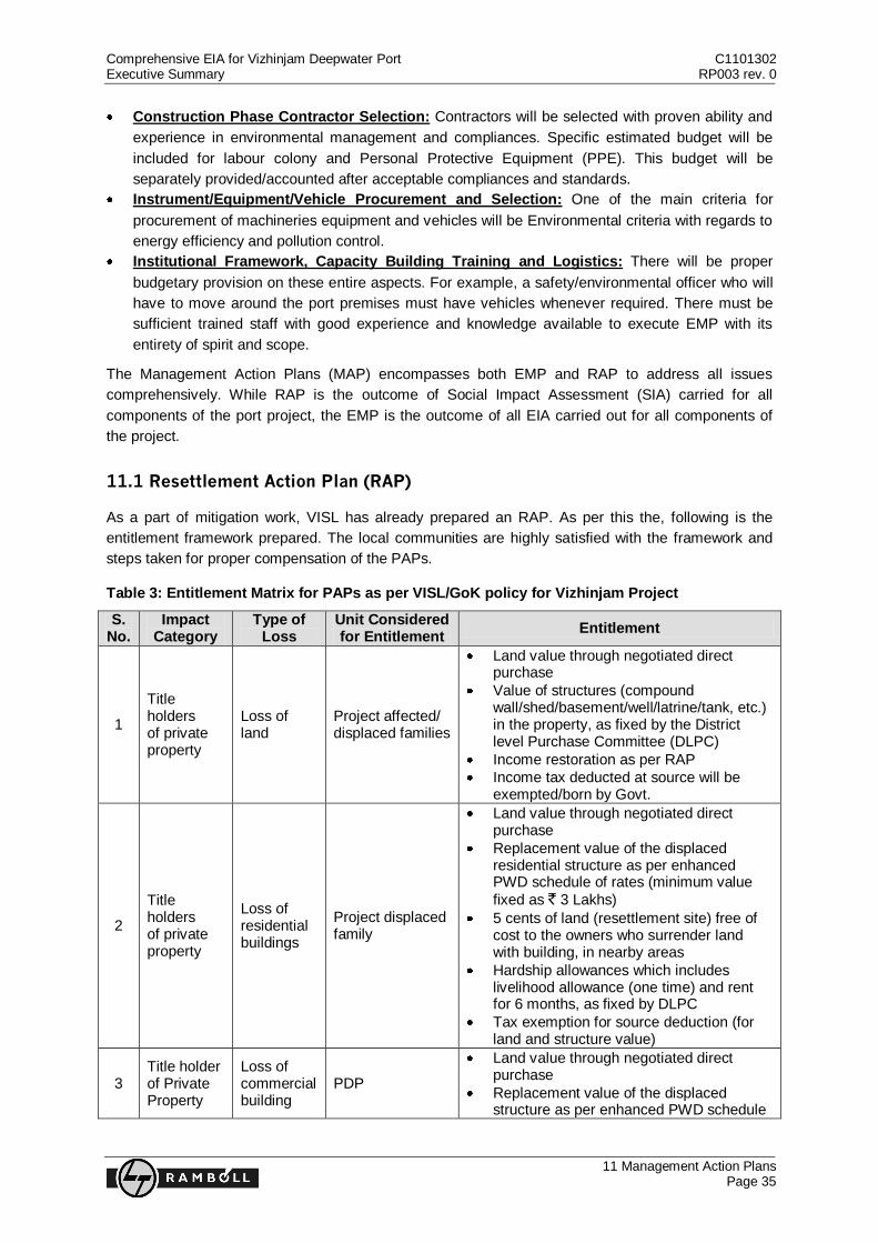
Comprehensive EIA for Vizhinjam Deepwater Port C1101302 Executive Summary RP003 rev. 0
11 Management Action Plans Page 35
Construction Phase Contractor Selection: Contractors will be selected with proven ability and
experience in environmental management and compliances. Specific estimated budget will be
included for labour colony and Personal Protective Equipment (PPE). This budget will be
separately provided/accounted after acceptable compliances and standards.
Instrument/Equipment/Vehicle Procurement and Selection: One of the main criteria for
procurement of machineries equipment and vehicles will be Environmental criteria with regards to
energy efficiency and pollution control.
Institutional Framework, Capacity Building Training and Logistics: There will be proper
budgetary provision on these entire aspects. For example, a safety/environmental officer who will
have to move around the port premises must have vehicles whenever required. There must be
sufficient trained staff with good experience and knowledge available to execute EMP with its
entirety of spirit and scope.
The Management Action Plans (MAP) encompasses both EMP and RAP to address all issues
comprehensively. While RAP is the outcome of Social Impact Assessment (SIA) carried for all
components of the port project, the EMP is the outcome of all EIA carried out for all components of
the project.
11.1 Resettlement Action Plan (RAP)
As a part of mitigation work, VISL has already prepared an RAP. As per this the, following is the
entitlement framework prepared. The local communities are highly satisfied with the framework and
steps taken for proper compensation of the PAPs.
Table 3: Entitlement Matrix for PAPs as per VISL/GoK policy for Vizhinjam Project
S. No.
Impact Category
Type of Loss
Unit Considered for Entitlement
Entitlement
1
Title holders of private property
Loss of land
Project affected/ displaced families
Land value through negotiated direct purchase
Value of structures (compound wall/shed/basement/well/latrine/tank, etc.) in the property, as fixed by the District level Purchase Committee (DLPC)
Income restoration as per RAP
Income tax deducted at source will be exempted/born by Govt.
2
Title holders of private property
Loss of residential buildings
Project displaced family
Land value through negotiated direct purchase
Replacement value of the displaced residential structure as per enhanced PWD schedule of rates (minimum value
fixed as ` 3 Lakhs)
5 cents of land (resettlement site) free of cost to the owners who surrender land with building, in nearby areas
Hardship allowances which includes livelihood allowance (one time) and rent for 6 months, as fixed by DLPC
Tax exemption for source deduction (for land and structure value)
3 Title holder of Private Property
Loss of commercial building
PDP
Land value through negotiated direct purchase
Replacement value of the displaced structure as per enhanced PWD schedule
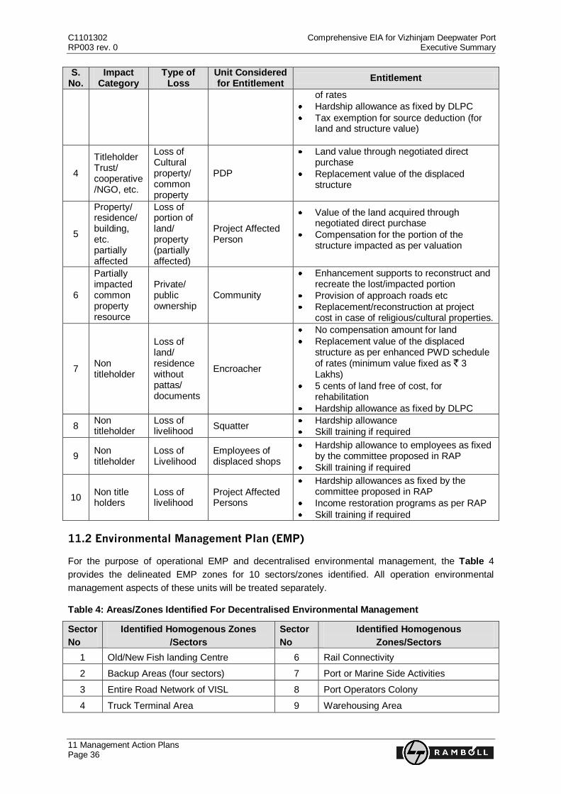
C1101302 Comprehensive EIA for Vizhinjam Deepwater Port RP003 rev. 0 Executive Summary
11 Management Action Plans Page 36
S. No.
Impact Category
Type of Loss
Unit Considered for Entitlement
Entitlement
of rates
Hardship allowance as fixed by DLPC
Tax exemption for source deduction (for land and structure value)
4
Titleholder Trust/ cooperative/NGO, etc.
Loss of Cultural property/ common property
PDP
Land value through negotiated direct purchase
Replacement value of the displaced structure
5
Property/ residence/ building, etc. partially affected
Loss of portion of land/ property (partially affected)
Project Affected Person
Value of the land acquired through negotiated direct purchase
Compensation for the portion of the structure impacted as per valuation
6
Partially impacted common property resource
Private/ public ownership
Community
Enhancement supports to reconstruct and recreate the lost/impacted portion
Provision of approach roads etc
Replacement/reconstruction at project cost in case of religious/cultural properties.
7 Non titleholder
Loss of land/ residence without pattas/ documents
Encroacher
No compensation amount for land
Replacement value of the displaced structure as per enhanced PWD schedule of rates (minimum value fixed as ` 3 Lakhs)
5 cents of land free of cost, for rehabilitation
Hardship allowance as fixed by DLPC
8 Non titleholder
Loss of livelihood
Squatter Hardship allowance
Skill training if required
9 Non titleholder
Loss of Livelihood
Employees of displaced shops
Hardship allowance to employees as fixed by the committee proposed in RAP
Skill training if required
10 Non title holders
Loss of livelihood
Project Affected Persons
Hardship allowances as fixed by the committee proposed in RAP
Income restoration programs as per RAP
Skill training if required
11.2 Environmental Management Plan (EMP)
For the purpose of operational EMP and decentralised environmental management, the Table 4
provides the delineated EMP zones for 10 sectors/zones identified. All operation environmental
management aspects of these units will be treated separately.
Table 4: Areas/Zones Identified For Decentralised Environmental Management
Sector
No
Identified Homogenous Zones
/Sectors
Sector
No
Identified Homogenous
Zones/Sectors
1 Old/New Fish landing Centre 6 Rail Connectivity
2 Backup Areas (four sectors) 7 Port or Marine Side Activities
3 Entire Road Network of VISL 8 Port Operators Colony
4 Truck Terminal Area 9 Warehousing Area
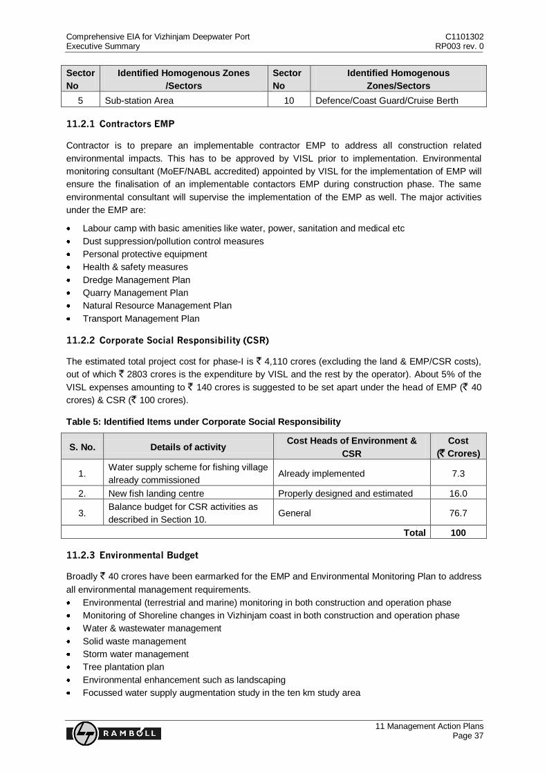
Comprehensive EIA for Vizhinjam Deepwater Port C1101302 Executive Summary RP003 rev. 0
11 Management Action Plans Page 37
Sector
No
Identified Homogenous Zones
/Sectors
Sector
No
Identified Homogenous
Zones/Sectors
5 Sub-station Area 10 Defence/Coast Guard/Cruise Berth
11.2.1 Contractors EMP
Contractor is to prepare an implementable contractor EMP to address all construction related
environmental impacts. This has to be approved by VISL prior to implementation. Environmental
monitoring consultant (MoEF/NABL accredited) appointed by VISL for the implementation of EMP will
ensure the finalisation of an implementable contactors EMP during construction phase. The same
environmental consultant will supervise the implementation of the EMP as well. The major activities
under the EMP are:
Labour camp with basic amenities like water, power, sanitation and medical etc
Dust suppression/pollution control measures
Personal protective equipment
Health & safety measures
Dredge Management Plan
Quarry Management Plan
Natural Resource Management Plan
Transport Management Plan
11.2.2 Corporate Social Responsibility (CSR)
The estimated total project cost for phase-I is ` 4,110 crores (excluding the land & EMP/CSR costs),
out of which ` 2803 crores is the expenditure by VISL and the rest by the operator). About 5% of the
VISL expenses amounting to ` 140 crores is suggested to be set apart under the head of EMP (` 40
crores) & CSR (` 100 crores).
Table 5: Identified Items under Corporate Social Responsibility
S. No. Details of activity Cost Heads of Environment &
CSR
Cost
(` Crores)
1. Water supply scheme for fishing village
already commissioned Already implemented 7.3
2. New fish landing centre Properly designed and estimated 16.0
3. Balance budget for CSR activities as
described in Section 10. General 76.7
Total 100
11.2.3 Environmental Budget
Broadly ` 40 crores have been earmarked for the EMP and Environmental Monitoring Plan to address
all environmental management requirements.
Environmental (terrestrial and marine) monitoring in both construction and operation phase
Monitoring of Shoreline changes in Vizhinjam coast in both construction and operation phase
Water & wastewater management
Solid waste management
Storm water management
Tree plantation plan
Environmental enhancement such as landscaping
Focussed water supply augmentation study in the ten km study area

L&T-RAMBØLL CONSULTING ENGINEERS LIMITED
6-3-1192/1/1, 5th Floor, Block No.3,
White House, Kundan Bagh, Begumpet, Hyderabad – 500 016
Ph: 91-040-40354444; Fax: 91-040-40354430