Embed Size (px)
Citation preview
ConCord Hills regional Parkland use Plan
Exist ing conditions rEport
July 20, 2015

ConCord Hills regional Parkland use Plan
Exist ing conditions rEport
In Association With:
ESA PWATrachtenberg Architects
Siegel & Strain ArchitectsH.T. Harvey & Associates
Donna GravesBKF Engineers
Timothy C. Best, CEG
Orange County • Northern California • Los Angeles/Downtown • Los Angeles/West • Inland Empire • San Diego
www.placeworks.com
July 20, 2015
This Document was prepared by:
Cover Photos Credit: Stephen Joseph

Concord Hills Regional Park Land Use Plan
Existing conditions report
Table of ConTenTs
Figures
1. Introduction 1Envisioning a Model Regional Park 2
Purpose and Overview of the Existing Conditions Report 3
2. Project Context 5Location 5
demographics 6
Regional Connectivity 6
Historical Context 11
CNWS Base Reuse Planning 22
Regional Planning Context 29
3. The Future Regional Park Site 35Existing Resources 35
Existing Uses and Activities 50
Existing Infrastructure 51
4. Opportunities and Constraints 65Open Space that is Highly Accessible to Urban Populations 65
A Critical Linkage for Regional Open Space and Trails 68
A Platform for Constructive and Creative Reuse 68
A Historic and Ecological Landscape that Resonates 69
A Sustainable Park Model 69
Figure 2-1. Regional and Local Setting 4
Figure 2-2. Site Context 4
Figure 2-3. Regional Open Space and Trail Connections 8
Figure 2-4. City of Concord Trails Master Plan 11
Figure 2-5. Timeline of Human Landscape Modification at the Future Regional Park Site (and Adjacent Areas) 14
Figure 2-6. Concord Reuse Plan 26
Figure 3-1. Site Map 34
Figure 3-2. Water and Biological Resources 41
Figure 3-3. Viewpoints 47
Figure 3-4. Trail Constraints Map 55
Figure 3-5. Existing Major Utility Network from Concord Community Reuse Plan 63
Figure 3-6. Water Infrastructure on Future Regional Park Site 63
Figure 4-1. Opportunities and Constraints 66

East Bay Regional Parks District
Existing conditions report
Concord Hills Regional Park Land Use Plan
Existing conditions report
Appendices
TablesTable 3-1. Existing Road and Rail Network 53
Table 3-2. Existing Buildings and Developed Sites 57
Appendix A Transportation and Circulation
Appendix B Hydrology and Water Resources
Appendix C Biological Resources
Appendix D Cultural Resources
Appendix E Building Evaluation Summary

viii East Bay Regional Parks District
Existing conditions report
Existing Conditions Report
East bay regional parks district concord Hills regional park Land Use plan
1 Concord Hills Regional Park Land Use Plan
Existing conditions report
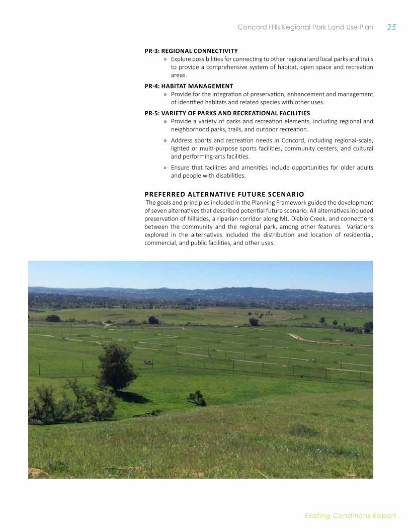
1. IntRoDUCtIon The Concord Naval Weapons Station (CNWS) has accommodated the changing needs of its inhabitants and settlers throughout decades, including local wildlife, miners, ranchers, and the United State Navy. For the last six decades, the property has been used exclusively by the military, limiting public access as well as private development. These limitations have allowed the CNWS to emerge as a prominent part of the East Bay landscape, offering striking grassland and hillside views while contributing to a substantial network of undeveloped open space.
CNWS is made up of two areas: the Tidal Area and the Inland Area. The Inland Area of the CNWS has been inactive since 1999. At that time, Congressman George Miller facilitated a study of potential joint uses to transition the area out of military use. CNWS was approved for closure by the Base Realignment and Closure Commission (BRAC) in 2005. Since the Inland Area is entirely located in the City of Concord, the City acted as the Local Reuse Authority (LRA) for the area and managed the planning process for reuse of the area. In 2012, the Concord City Council adopted the Concord Reuse Project Area Plan (Area Plan), which defined a community-supported vision for the development and conservation of the Inland Area. The Tidal Area, including the Military Ocean Terminal Concord (MOTCO) and the Port Chicago Naval Magazine National Memorial, was transferred to the Army following base closure and is not within the Area Plan.
The Area Plan provides a vision for a world-class development with integrated mass transit; expansive new housing options (approximately 12,200 new units); nearly 6 million square feet of commercial space; and a diversity of parks, greenways, and open spaces. One of the central features of the Area Plan is a regional park that will occupy western slopes of the Los Medanos Hills and the adjacent area to Mt. Diablo Creek, which is the focus of this Existing Conditions Report. The regional park will serve as key piece within the green space network of the development and serve to complement the more active park spaces within the community. Additionally, emphasis on public transit and non-motorized connectivity within the Area Plan ensures that the regional park will be a resource for both the neighbors in close proximity and the larger Bay Area community.
It is anticipated that the Navy will convey the Inland Area of the CNWS to the City and its partners in 2016, completing a critical step towards realizing the vision defined in the Area Plan. The neighborhood area is anticipated to be conveyed to the City through

2 East Bay Regional Parks District
Existing conditions report
an Economic Development Conveyance (EDC) and the Future Regional Park site will be transferred to the East Bay Regional Park District (District) under a Public Benefit Conveyance (PBC) through the National Park Service (NPS) Federal Lands Program.
EnvIsIonIng a MoDEL REgIonaL PaRk The future regional park has been referred to as the Concord Hills Regional Park. While this name helps to distinguish it from planned city parks within the Area Plan, it is anticipated that the name may change to better reflect the park’s unique history and characteristics. For this reason, it is referred to as the Future Regional Park site within this report.
Building upon the Area Plan, the District is preparing a Park Land Use Plan that will provide further guidance for the development and operation of the Future Regional Park site. The Park Land Use Plan will refine the regional park vision, identify implementation and phasing strategies necessary to realize the vision, and inspire community engagement and park development. In addition to defining uses internal to the Regional Park site, the Park Land Use Plan will further explore the relationship between the Regional Park site and the community development, from recreational connections to habitat restoration and mitigation.
The Future Regional Park site has the potential to be world-class facility given the wealth of natural and cultural resources possessed within its boundaries, as well as its physical connections to both regional open space and urban areas. The site is located approximately three miles south of the Port Chicago Naval Magazine National Memorial, which commemorates the largest homefront disaster of World War II and the subsequent events that led to the desegregation of the military.
The Memorial was dedicated in 1994 and became a unit of the National Park System in 2009 when President Obama approved H.R. 2647, the National Defense Authorization Act for Fiscal Year 2010. Recognizing that public access must be restricted to the Memorial due to its location within the active Tidal Area of the CNWS, H.R. 2647 also authorized NPS to work in partnership with the City of Concord and the District towards the establishment and operation of a jointly-operated visitor center. This visitor center would expand access to the Port Chicago Naval Magazine National Memorial story through interpretative features. The District and NPS have been planning for this facility to be located within the Future Regional Park, and signed a Cooperative Management Agreement in 2015 that formalizes this relationship and furthers these efforts.
In addition to the joint visitors center, uses envisioned for the Future Regional Park site include regional trail and open space connections, trail connections to the EDC
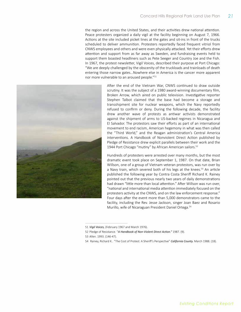
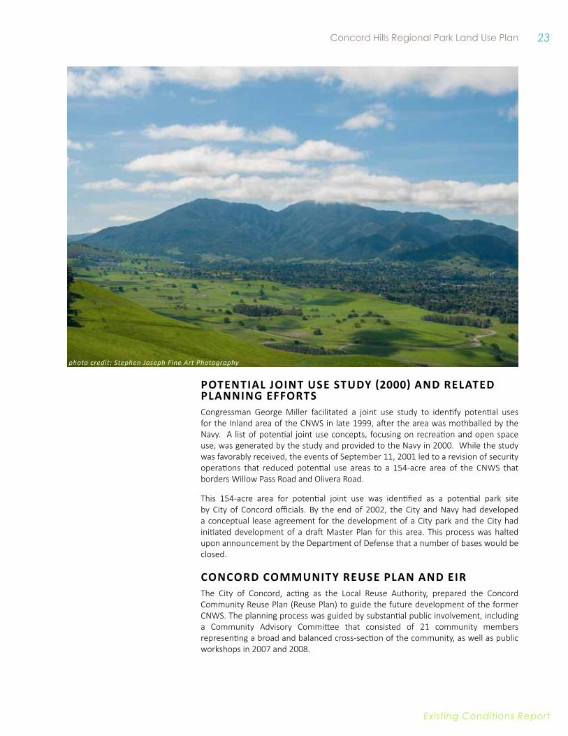
photo credit: Stephen Joseph Fine Art Photography

3 Concord Hills Regional Park Land Use Plan
Existing conditions report
area and other adjacent communities, extensive resource preservation enhancement, environmental and historic interpretation, and low-impact recreational uses that complement active uses envisioned for new City parks within the EDC area.
PURPosE anD ovERvIEw of tHE ExIstIng ConDItIons REPoRt The purpose of the Existing Conditions Report is to inform the preparation of the Park Land Use Plan by summarizing the dynamic planning context, identifying the site’s existing conditions, and highlighting key opportunities and constraints for development of a new regional park.
This Existing Conditions Report is based on review of existing documents and studies, fieldwork, and supplemental studies conducted for the purposes of this planning process. The Report is organized as follows:
• Project Context. This Chapter provides an overview of regional connections, historical context, and the planning context for the project.
• The Future Regional Park Site. This Chapter explores existing resources, current site uses and activities, and existing infrastructure. In addition to describing on-the-ground conditions, this Chapter discusses how the conditions can inform park development.
• Summary of Opportunities and Constraints. The Report concludes with a brief summary of key opportunities and constraints for development of the future park, with consideration to site context and site conditions.photo credit: Stephen Joseph Fine Art Photography
Existing conditions report
4 East Bay Regional Parks District
Oakland
Vallejo
Antioch
Alamo
Danville
Benicia
Oakley
Richmond
Novato
San Francisco
Pittsburg
Orinda
Lafayette Walnut Creek
San Rafael
Martinez
Moraga
Rodeo
Brentwood
Fairfield
Bay Point
Alameda
Pinole
Rio Vista
Hercules
Discovery Bay
San Ramon
Crockett
Pleasant Hill Clayton
Knightsen
Tiburon
Bethel Island
Byron
El Cerrito
Larkspur
Tracy
Blackhawk-Camino Tassajara
Albany
American Canyon
Sausalito
El Sobrante
Diablo
Pacheco
Isleton
PetalumaWalnut GroveNapa
Lathrop
CONCORDCONCORD
Suisun BaySan Pablo
Bay
San Francisco
Bay
Pacific Ocean
%&'(680
4
24
%&'(680
%&'(80
%&'(80
%&'(580
0 5 102.5
Miles
City of Concord East Bay Regional Parks Major RoadsOther Open Space Bart Line/Station
Future Regional Park Site
EDC Area Concord Reuse Plan Area
Will
ow P
ass R
oad
Concord Boulevard
Clayton Road
Baile
y Ro
ad
Kirk
er Pass R oad
Concord Avenue
%&'(680
4
242
Port
Chi
cago
Hig
hway
KellerCanyonLandfill
EBRPD Land Bank
Southern Area
Primary Area
Concord Pavilion
KellerCanyonLandfill
EBRPD Land Bank
Southern Area
Primary Area
Concord Pavilion
0 0.5 10.25
Miles
EDC AreaFuture Regional Park Site (PBC Area) East Bay RegionalParks Existing Trails
Other Open Space Bart Line/StationCity of ConcordCity of Pittsburg
Figure 2-1. Regional and Local Setting
Figure 2-2. Site Context
Existing conditions report
5 Concord Hills Regional Park Land Use Plan
2. PRojECt ContExtThe planning context in which the Concord Hills Regional Park Land Use Plan will be developed is summarized in the Chapter according to the topic areas of regional connectivity, history, Concord Naval Weapons Station (CNWS) Base Reuse Planning, regional planning, and City planning.
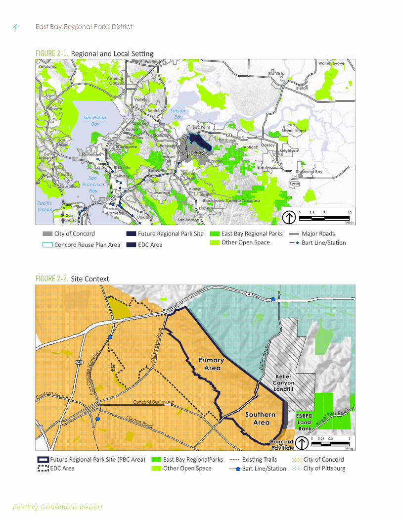
LoCatIonThe Future Regional Park site is located in the eastern portion of the City of Concord, along the Los Medanos Hills. Elevations at the site range from about 100 feet above sea level in the northwestern portion of the site to 1,000 feet above sea level along the ridge. This area is part of the historic Monte del Diablo land grant area, which included a 17,921 acre area from Mount Diablo foothills to the San Francisco Bay deeded to Don Salvio in 1834.
Today, as shown in Figure 2-2, the Future Regional Park site sits at the border of the cities of Concord and Pittsburg. The site along with undeveloped land along this border, form a greenbelt between the two municipalities. The development of the Regional Park would formalize this condition and create a greenway between the two urban areas. The Future Regional Park site is bounded on the north and west by the Concord Reuse Project Area’s Economic Development Conveyance (EDC) area, on the southwest by existing residential neighborhoods within the City of Concord, and on the south and east by undeveloped land within the City of Pittsburg and unincorporated Contra Costa County. Primary uses adjacent to the Park include residential properties within the City of Concord and agricultural land in the City of Pittsburg and in unincorporated areas. The eastern edge is predominately used for agricultural grazing. It is privately owned and located within the City of Pittsburg’s Sphere of Influence.
The Future Regional Park site is located west of the Keller Canyon Landfill to the north, which has been in operation since 1992 and is currently negotiating an agreement with the County to expand capacity from 3,500 to 4,900 tons per day. The eastern and southern edges, located within the City of Concord, are primarily developed with single family residential properties. Concord Pavilion, a regional cultural destination, is located to the south of the site.
The Future Regional Park site is bisected into two segments north and south of Bailey Road. The northern section (Primary Area), located between Bailey Road and Highway 4, is significantly larger, totaling approximately 1,740 acres, and contains most of the

6 East Bay Regional Parks District
Existing conditions report
existing structure and a more complex road and rail network. Willow Pass Road crosses the Primary Area along an overpass at the northwestern edge. The southern section (Southern Area), totaling approximately 890 acres, is less developed with a small network of magazines along a loop road.
DEMogRaPHICsAlthough the Future Regional Park site will be a regional asset to the Bay Area, residents in the nearby cities and communities, including the City of Concord, the City of Pittsburg, and the unincorporated community of Bay Point are likely to be the most frequent visitors. Existing populations of these communities are described below; however, the population and demographics of communities throughout the region are likely to reflect statewide demographic changes, which includes a rapidly increasing Latino population.1
In 20132, the estimated population of the City of Concord was 123,658; the median age was 37.1 years, while 25 percent of the population was under 19-years old. Nearly half the population (49.8 percent) is White, 29.5 percent is Hispanic or Latino, and 11.5 percent is Asian, with other ethnicities making up smaller percentages of the population.3 The population and demographics of Concord are likely to change with the development of the EDC area, which is expected to bring approximately 12,200 new housing units to the area. These units are likely to attract young families and young professionals looking for housing near transit.
In 2013, the estimated population of the City of Pittsburg was 63,264; the median age was 33.2 years, while 29 percent of the population was under 19 years-old. Approximately 41.5 percent of the population is Hispanic or Latino, 19.3 percent is White, 18.7 percent is African American, and 14.4 percent is Asian, with other ethnicities making up smaller percentages of the population.
In 2013, the estimated population of Bay Point was 21,349; the median age was 30.2 years, while 35 percent of the population was under 19 years-old. Over half of the population is Hispanic or Latino (56.9 percent), 21.1 percent is White, and 11.2 percent is African American, with other ethnicities making up smaller percentages of the population.
REgIonaL ConnECtIvItyThis section summarizes key regional connections that inform the development of the Future Regional Park site, including open space and trail connections that tie the site to the regional landscape, and the regional transportation system that accesses the site. Implications of the site context on future park development are addressed in the discussion of the Future Regional Park site in Chapter Four.
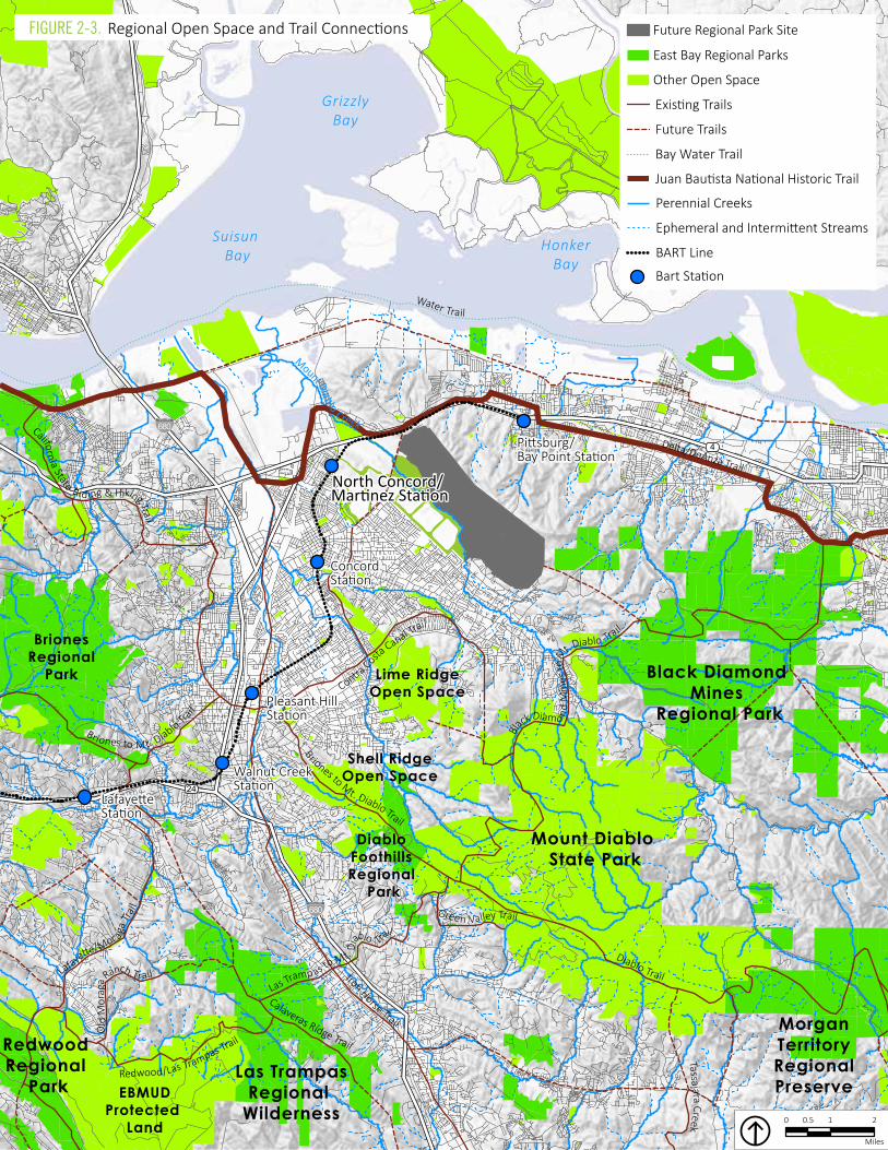
Regional oPen SPaCe and TRail ConneCTionS The Future Regional Park site is located in close proximity to other East Bay Regional Parks District lands and other open space areas, with a nearly continuous string of protected lands extending from the Park into Black Diamond Mines Regional Preserve, Mount Diablo State Park, Morgan Territory Regional Preserve, Los Vaqueros Watershed
1 California State Parks. 2005. Parks and Recreation Trends in California.2 United States. Department of Commerce. Census Bureau. American Community Survey Demographic
and Housing Estimates. 2009-2013 American Community Survey 5-Year Estimates. 3 The ethnicity categories used in this document (i.e. African American, Asian, Latino, White, and Other)
are derived from the 2010 US Census.
7 Concord Hills Regional Park Land Use Plan
Existing conditions report
(protected by Contra Costa Water District) and Marsh Creek State Park. Extending existing trails between the Future Regional Park site and these protected spaces, and creating new trail connections, will significantly expand the trail network, enhancing both recreation and transportation opportunities in the region.
Particularly valuable trail connections will include:
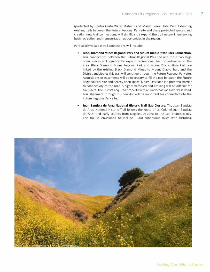
• Black Diamond Mines Regional Park and Mount Diablo State Park Connection. Trail connections between the Future Regional Park site and these two large open spaces will significantly expand recreational trail opportunities in the area. Black Diamond Mines Regional Park and Mount Diablo State Park are linked by the existing Black Diamond Mines to Mount Diablo Trail, and the District anticipates this trail will continue through the Future Regional Park site. Acquisitions or easements will be necessary to fill the gap between the Future Regional Park site and nearby open space. Kirker Pass Road is a potential barrier to connectivity as the road is highly trafficked and crossing will be difficult for trail users. The District acquired property with an underpass at Kirker Pass Road. Trail alignment through this corridor will be important for connectivity to the Future Regional Park site.
• Juan Bautista de Anza National Historic Trail Gap Closure. The Juan Bautista de Anza National Historic Trail follows the route of Lt. Colonel Juan Bautista de Anza and early settlers from Nogales, Arizona to the San Francisco Bay. The trail is envisioned to include 1,200 continuous miles with historical
photo credit: Stephen Joseph Fine Art Photography
8 East Bay Regional Parks District
Existing conditions report
Water Trail
Iron Horse Trail
Diablo Trail
Delta/DeAnza Trail
Tassajara Creek
Contra Costa
Canal Trail
Calaveras Ridge Trail
Briones to Mt. Diablo Trail
Redwood/Las Trampas Trail
Green Valley Trail
Briones to Mt. Diablo Trail
Black Diamo n d
Min
es to
M
t. Diablo Trail
Las Tramp as to Mt. D
iablo Trail
California State Riding & Hiking Trail
Ol d
Mor
aga R
anch TrailLafayette/Mor ag
a Tra
il
Concord Station
Walnut Creek Station
Pleasant HillStation
Pittsburg/ Bay Point Station
North Concord/ Martinez Station
Lafayette Station
Concord Station
Walnut Creek Station
Pleasant HillStation
Pittsburg/ Bay Point Station
North Concord/ Martinez Station
Lafayette Station
%&'(680
4
24
%&'(680
Suisun Bay
GrizzlyBay
HonkerBay
Mount Diablo State Park
Black Diamond Mines
Regional Park
Lime RidgeOpen Space
BrionesRegional
Park
Las TrampasRegional
WildernessEBMUD
Protected Land
Redwood Regional
Park
Diablo Foothills Regional
Park
Shell RidgeOpen Space
MorganTerritoryRegionalPreserve
Mount Diab lo Creek
0 1 20.5
Miles
East Bay Regional Parks
Existing Trails
Other Open Space
Bay Water Trail
Future Trails
Future Regional Park Site
Juan Bautista National Historic Trail
BART Line
Ephemeral and Intermittent Streams
Perennial Creeks
Bart Station
Figure 2-3. Regional Open Space and Trail Connections
9 Concord Hills Regional Park Land Use Plan
Existing conditions report
interpretation of this journey across the west. Although the National Historic Trail is administered by the National Parks Service, the trail utilizes right-of-ways from other administrative bodies, including East Bay Regional Parks District. The Delta de Anza Trail, the Bay Area Ridge Trail, Iron Horse Trail, Marsh Creek Trail, and Ohlone Wilderness Trail are among the regional trails that comprise this National historic Trail. The vision for the Juan Bautista de Anza National Historic Trail is continuous; however, it is still segmented in many areas, including eastern Contra Costa County. The proposed route for the Juan Bautista de Anza Historic Trail connects through the EDC area from the Delta de Anza trail segment on the east to a proposed alignment through the City of Concord to the Iron Horse Trail and to a future trail along Pacheco Creek and out to the Bay Trail.
• Contra Costa Canal to Delta de Anza Regional Trail Gap Closure. The multi-use trail Contra Costa Canal currently terminates in the City of Concord west of the Future Regional Park site with a planned extension to the western edge of the Concord Naval Weapons Station (CNWS). The Delta de Anza Regional Trail terminates at the eastern edge of the CNWS in the City of Pittsburg. Connection through the Future Regional Park site will link these two regional trails and create a multi-modal connection between Concord and Pittsburg, and to the Delta for East Bay residents. This gap closure will connect the site to other regional trails, including the Iron Horse Trail, the California Riding and Hiking Trail, and the San Francisco Bay Trail.
The planned trail along Mount Diablo Creek will increase regional trail connectivity and create a potential pedestrian or non-vehicular access point into the Future Regional Park site. The proposed Mount Diablo Creek Trail will connect the Contra Costa Canal Trail with Bailey Road. Access trails into the Future Regional Park site could link to this corridor.
Regional TRanSPoRTaTion4 Access to the Future Regional Park site will be multi-modal and will accommodate vehicular access from the surrounding area, as well as transit, pedestrian, and bicycle options.
exTeRnal Road neTwoRk There are three highways in proximity to the northwest boundary of the Future Regional Park site, including Highways 4 and 242, and Interstate 680. Willow Pass Road crosses the site in a northeasterly direction and provides access to Highway 4 just north of the site. Bailey Road crosses the southeast portion of the site in a northeasterly direction and then joins Highway 4 in western Pittsburg. Access to northern and southern sections of the Future Regional Park site was limited to monitored entry points along Bailey Road during operation and continues to be very limited. The primary entrance point to the Future Regional Park site is through the Military Ocean Terminal of Concord off of Port Chicago Highway to the north of the Highway 4, from which several roads connect south into the Future Regional Park site.
Based on current traffic levels and not considering new impacts from future developments, most of the roadways and intersections around the Future Regional Park site are within the acceptable Level of Service (LOS) standard for Contra Costa County and the City of Concord. For a detailed description of the these LOS standards, see Appendix A. Exceptions to acceptable service levels are Willow Pass Road (north
4 Information included in this section was compiled from the Transportation and Circulation Study prepared by Environmental Science Associates (ESA) and included in Appendix A.
10 East Bay Regional Parks District
Existing conditions report
of Landana Drive) and Bailey Road (east of Concord Boulevard), both of which operate at below the local standard during morning and evening peak traffic hours: Willow Pass Road and the Highway 4 westbound ramps, Willow Pass Road and the Highway 4 eastbound ramps, and Bailey Road and the Highway 4 eastbound ramps.
While several of the local and regional roadways in the project vicinity are at or near capacity during weekday AM and PM peak hours, it is worth noting that park developments typically do not generate many new trips during weekday peak hours. Conversely, roadway traffic conditions on weekends, when park developments typically generate most of their new trips, are typically better (less traffic) than during weekday peak hours. As such, roadway performance is not anticipated to be a major planning constraint for the Future Regional Park site.
TRanSiT The North Concord/Martinez Bay Area Rapid Transit (BART) Station is located to the west of the site, off Port Chicago Highway. The Future Regional Park site is also located in proximity to the Concord Station off Oakland Avenue south of downtown Concord and the Pittsburg/Bay Point Station off Bailey Road. The Future Regional Park site’s proximity to public transit facilities, in particular the North Concord/Martinez BART station, makes it particularly well suited to become an important gateway into this expansive open space network. Green connections from the BART station to the Park planned as part of the Concord Reuse Plan will provide important services linkages to open space for non-vehicular users, potentially opening up the network to visitors who do not have access to or prefer not to use motorized vehicles.
The Central Contra Costa Transit Authority, or County Connection, provides fixed-route and paratransit bus service in Concord and has several routes that provide service near the Future Regional Park site, including routes 10, 15, 17, 28/627, and 93X; and several lines that connect to the three BART stations.
Tri Delta Transit provides bus service in east Contra Costa County with routes that connect Concord with the cities of Bay Point, Pittsburg, Antioch, Oakley, Brentwood, and Discovery Bay. Route 201 provides service between the Concord Station and the Pittsburg/Bay Point Station, where transfers can be made to eleven other Tri Delta Transit bus routes.
The City of Concord General Plan indicates additional transit service is planned for the CNWS Reuse Project area that would connect to BART stations and other Concord neighborhoods.
BiCyCle and PedeSTRian FaCiliTieSThe Concord General Plan proposes a network of Class I and II bicycle facilities for the redevelopment of the CNWS Reuse Project area. Contra Costa County identifies several Class I trails in the Future Regional Park site, including the Contra Costa Canal Trail and the Iron Horse Trail, as well as Class II Bicycle Lanes and Class III Bicycle Route facilities. The City of Concord Trails Master Plan, shown in Figure 2-4, identifies trail opportunities within the Future Regional Park site, including trails along the ridge, Mount Diablo Creek, the Clayton Canal and the Contra Costa Canal, as well as a network of internal trails with undetermined alignments. The Trails Master Plan also identifies trail connections into the CNWS along Bailey Road and Treat Boulevard (from Galindo Creek Trail), and proposed “Panoramic Way Trail,” connecting Willow Pass Road to the North Concord BART station. The numbers identified in red in Figure 2-4 correspond to trails characterized in the City of Concord Trails Master Plan.

11 Concord Hills Regional Park Land Use Plan
Existing conditions report
HIstoRICaL ContExt5 In addition to recreational and environmental benefits, Concord Hills Regional Park offers unique opportunities for interpreting aspects of local, regional, and national history reflected in the landscape and human-made features of the area. This section provides a brief summary of the Future Regional Park site’s history from Native American and Mission Periods to the closure of the Inland Area of the CNWS in 2005.
NATive AMeRiCAN & MiSSiON PeRiODS (4000 BCe TO 1821)As early as 4000 BCE, Native American groups are known to have inhabited the East Bay region. Marshlands along the edge of San Francisco Bay and inland waterways served as important geographic features for Native Americans who hunted waterfowl, fished, and harvested shellfish along their banks. A group now known as the Bay Miwok lived in the general vicinity of the project area in terrain that extended from East Contra Costa County to the Sacramento-San Joaquin Delta. The Bay Miwok were part of the Utian language-based group along with Ohlone peoples who lived throughout the San Francisco Bay Area.
A 300 to 400-member subgroup, known as the Chupcan, inhabited the lower Diablo Valley, including the project area and what are now the nearby town sites of Concord,
5 This section was prepared primarily by Donna Graves in 2015.
Figure 2-4. City of Concord Trails Master Plansource: Wilbur Smith Associates
12 East Bay Regional Parks District
Existing conditions report
Walnut Creek, and Clayton. Many California Native Americans like the Chupcans saw themselves not as part of larger groups tied by region or language, but as “members of specific villages, perhaps related to others by marriage or kinship ties, but viewing the village as the primary identifier of their origins.”6
The Chupcan lived along fresh-water streams that flowed northward to the tule marshes on the Bay.7 Their villages would have been made up of numerous dome-shaped structures made of willow branches and tule reeds. These buildings housed sweat lodges and residences, which ranged in size from six to twenty feet wide and could house several generations of a family.8 In the colder season, families lived in subterranean pit houses.9 Men hunted deer, elk, and antelope with spears, and bows and arrows. They used nets, spears, and basket traps to fish on creeks, rivers, and in the bay, sometimes from tule boats. Women were basket makers and gathered most of the village plant food including roots, bulbs, mushrooms, leaves, nuts, and berries. In early autumn, entire villages would journey to the slopes of Mount Diablo to gather acorns, their most important food, from oak trees.
The earliest European presence in the present-day Concord area was a 1772 visit to the East Bay by Spanish explorers Captain Pedro Fages and Father Juan Crespi.. On March 31st, Crespi described an encounter with Native American residents in the San Ramon Valley, south of the project area. The Spanish came upon “three villages with some little grass houses. As soon as the heathen caught sight of us they ran away, shouting and panic-stricken.”10
According to one account, Spanish soldiers later captured a group of Chupcan in 1805. The Chupcan escaped, and the astonished Spanish named the area Mount Diablo (devil) in response. A nearby Miwok sub-group, the Saclans, reportedly fought the Spanish for nearly ten years to keep their villages and lives intact.11
Early Spanish expeditions led to occupation and settlement. In 1776, Mission San Francisco de Asis, or “Mission Dolores,” was founded across the bay in what is now the City of San Francisco. Missions ringing the bay followed in the next few years: Mission Santa Clara de Asis in 1777 (in present-day San Jose), Mission San Jose in 1797 (in present-day Fremont), Mission San Rafael (in present-day San Rafael), and finally Mission San Francisco de Solano in 1823 (in present-day Sonoma). Catholic missionaries enforced a program of indoctrination to mission life and religious conversion of the local peoples. The Chupcan people were conscripted into the Catholic mission system at Mission Dolores, where various native peoples were intermingled, eventually resulting in the dissolution of distinct tribal entities.12
6 ESA, Cultural Resource Study. See Appendix D.7 Contra Costa County Office of Education, “The Bay Miwok of Contra Costa County.” <http://www.cccoe.
net/miwokproject/Lesson1.html>8 Contra Costa County Office of Education, “The Bay Miwok of Contra Costa County,” http://www.cccoe.
net/miwokproject/Lesson2.html9 ESA, Cultural Resource Study. See Appendix D.10 San Ramon Valley Historical Society, “They Came First: The Indians of the San Ramon Valley,” (updated
2014) 3.11 San Ramon Valley Historical Society, “They Came First: The Indians of the San Ramon Valley,” (updated
2014) 2, 4.12 “Bay Miwok.” Wikipedia, The Free Encyclopedia. Wikimedia Foundation. < http://en.wikipedia.org/wiki/
photo credit: Stephen Joseph Fine Art Photography
13 Concord Hills Regional Park Land Use Plan
Existing conditions report
The spread of diseases for which the Native Americans had no immunity accompanied Europeans to California and decimated the native population.13 Over seventy-five per cent of the region’s native peoples are estimated to have perished by 1815. Those that survived under the auspices of the missions lived in conditions of poverty and near starvation. Though other Miwok sub-groups survived, historians believe that the impact of Spanish colonization and the mission system drove the Chupcan to disappear as a distinct tribal entity.14
MexiCAN AND eARly AMeRiCAN PeRiOD (1821 TO 1895)After Mexico gained independence from Spain in 1821, the new government took over what is now California and disbanded, or secularized, the Spanish missions. In a program intended to encourage colonization and make land more accessible to the average Californio (as Mexican citizens in California were called), church land and property were redistributed through land grants. The large land grants known as Rancho Los Medanos (8,859 acres) and Rancho Monte del Diablo (17,921 acres covering most of present-day Concord and the project area) were given in the 1830s and encompassed mountains, plains, and coastal areas between the current communities of Walnut Creek and Concord to Antioch and Pittsburgh.15 16 The ranchos were primarily used as cattle operations.
The American period in California began in 1846 when California was ceded to the United States after the Mexican-American War. Numerous Americans had already settled in the region, often as squatters, which contributed to the tension between Mexicans and Americans in California. With California officially under American control, land grants, deeds, and titles to property became even more clouded—it generally took nearly 50 years to resolve the situation and led to slow development
Bay_Miwok >13 “Milestone for S.F. Mission,” San Francisco Chronicle, January 12, 2004.14 ESA, Cultural Resource Study. See Appendix D.15 John A. Keibel, Behind the Barbed Wire: History of Naval Weapons Station Concord 2009. (193). 16 ESA, Cultural Resource Study. See Appendix D.
photo credit: Stephen Joseph Fine Art Photography
14 East Bay Regional Parks District
Existing conditions report
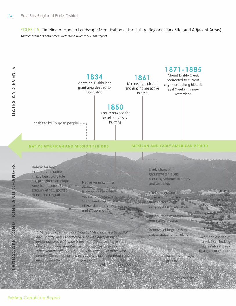
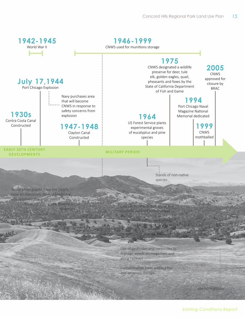
1834Monte del Diablo land grant area deeded to
Don Salvio
Inhabited by Chupcan people
1861Mining, agriculture,
and grazing are active in area
Habitat for large mammals including, grizzly bear, wolf, tule elk, pronghorn antelope, American badger, San Joaquin kit fox, spotted skunk, and ringtail
Likely change in groundwater levels, reducing volumes in seeps and wetlands
Likeley degration of riparian and wetland habitat from cattle congregating in wet areas
Introduction of annual, non-native grasses
Removal of large oaks to create space for farmland
1850Area renowned for
excellent grizzly hunting
Native American fire management practices likely helped reduce vegetation density and shape landscape mosaic of grassland, oak savannah and shrublands
“The region north and northwest of Mt Diablo is a beautiful one – pretty valleys scattered over with oaks, many of enormous size, with wide branches, often dropping like the elm. The rugged mountain rises against the clear sky, and when illuminated by the setting sun is an object of peculiar beauty. Our camp was in a very pretty place, with great trees around, and the mountain in full view”
-William Brewer, 1860
1871-1885Mount Diablo Creek redirected to current
alignment (along historic Seal Creek) in a new
watershed
Decreased groundwater
recharge in native groundwater basin
Increased incision in channel
downstream of realignment point
Aesthetic change of creek from looking like a natural creek
to a gully or channel
lAN
DSC
APE
CO
ND
ITIO
NS
AN
D C
HA
NG
ESD
ATE
S A
ND
EV
ENTS
Reduction in large predators
Increase in smaller prey species
NATive AMeRiCAN AND MiSSiON PeRiODS MexiCAN AND eARly AMeRiCAN PeRiOD
Figure 2-5. Timeline of Human Landscape Modification at the Future Regional Park Site (and Adjacent Areas)source: Mount Diablo Creek Watershed Inventory Final Report
15 Concord Hills Regional Park Land Use Plan
Existing conditions report
1994Port Chicago Naval Magazine National
Memorial dedicated
Extensive construction of rail and roadway network and drainage ditches
» Altered drainage patterns » Reduced soil moisture
Development of magazines and administrative buildings
Use of pesticides and herbicides to manage weeds on magazines and along railways
Contamination from artillery fire and weapons storage
1930sContra Costa Canal
Constructed 1947-1948Clayton Canal Constructed
1942-1945World War II
“Aerial photographs from the 1930’s show an intensively farmed landscape with relatively few large trees.”
- Mount Diablo Creek Watershed Inventory
July 17,1944Port Chicago Explosion
Navy purchases area that will become CNWS in response to safety concerns from explosion 1964
US Forest Service plants experimental groves
of eucalyptus and pine species
1975CNWS designated a wildlife
preserve for deer, tule elk, golden eagles, quail,
pheasants and foxes by the State of California Department
of Fish and Game
1946-1999CNWS used for munitions storage
site remediation
2005CNWS
approved for closure by
BRAC
Stands of non-native species
eARly 20TH CeNTuRy DevelOPMeNTS MiliTARy PeRiOD
1999CNWS
mothballed

16 East Bay Regional Parks District
Existing conditions report
of land. Rancho Los Medanos was sold by its original owners, Jose Antonio Mesa and Jose Miguel Garcia, in two separate parcels. The community of Pacheco was named for patriarch Salvio Pacheco. The Pacheco family was successful in defending their claim to Rancho Monte del Diablo under the US court system.17 18
The California Gold Rush of 1849 transformed the state and initiated California’s multiple cycles of economic dependence on extraction industries. Cattle ranching, orchards, and sheep grazing dominated use of the landscape until discovery of coal on the slopes of Mount Diablo led to an influx of population as mining took hold. A growing network of railroad lines aided the region’s increase in population and industry.19 The mining boom reportedly ended in the 1880s and agricultural use of much of the project area resumed its prominence with establishment of new dairy farms, walnut orchards, and grain fields.20
At the same time, wharves and warehouses were erected along the waterfront in what is now known as the Tidal Area of the CNWS. The area, then known as Seal Bluff, was found to be ideal for transshipment as new rail lines could reach ships using the deep-water passage of the Carquinez Strait. From the 1890s to the early 1900’s, the Copper King Smelting Company operated from Seal Bluff Landing. Its employees helped to support a new post office, a general store, and a saloon. The failed copper smelting business was replaced in 1908 by the C.A. Smith Lumber Company, a large lumber processing plant that employed over 2,000 workers. C.A. Smith established the company town community of Bay Point, which was later renamed Port Chicago.21 22
eARly 20TH CeNTuRy DevelOPMeNTSThe new Bay Point & Clayton Railroad, and the Oakland, Antioch and Northern Railway were incorporated in the early 20th century; but the greatest transformation of the area began in 1917 when shipbuilding for the US War Department began at Bay Point. As the area boomed with activity, the town of Clyde, located between the Inland Area and the Tidal Area of the CNWS, was established to provide housing and businesses to serve employees. Although production closed down at the end of the war, the surrounding towns’ populations reportedly remained stable.23
Other additions to the landscape were the Contra Costa Canal and Clayton Canals, portions of the enormous and innovative water distribution project implemented by the US Bureau of Reclamation’s Central Valley Project. The increasing demand for freshwater from California’s growing agricultural, industrial, and urban sectors pointed out the need for a comprehensive approach, which included a system of reservoirs
17 “Rancho Los Medanos.” Wikipedia, The Free Encyclopedia. Wikimedia Foundation. <http://en.wikipedia.org/wiki/Rancho_Los_Medanos>
18 “Rancho Monte del Diablo.” Wikipedia, The Free Encyclopedia. Wikimedia Foundation. <http://en.wikipedia.org/wiki/Rancho_Monte_del_Diablo>
19 JRP Historical Consulting Services, “Historic Building Inventory and Evaluation: Inland Area, Concord Naval Weapons Station.” 2009. (13).
20 Keibel. 2009. (193).21 Keibel. 2009. (8, 190).22 JRP Historical Consulting Services. 2009. (13-14).23 JRP Historical Consulting Services. 2009. (14).
17 Concord Hills Regional Park Land Use Plan
Existing conditions report
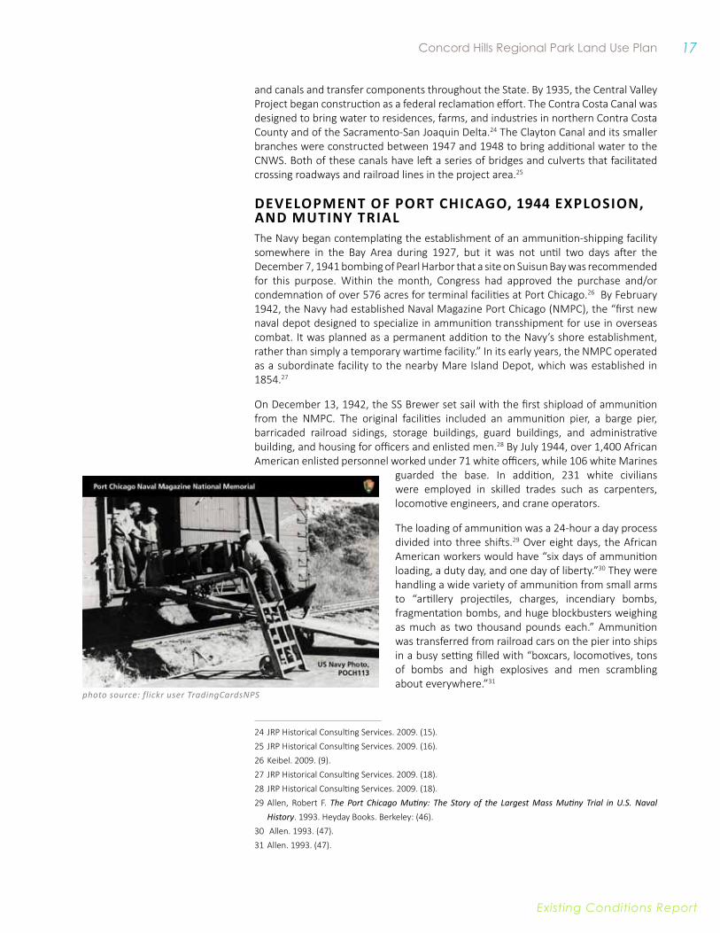
photo source: flickr user TradingCardsNPS
and canals and transfer components throughout the State. By 1935, the Central Valley Project began construction as a federal reclamation effort. The Contra Costa Canal was designed to bring water to residences, farms, and industries in northern Contra Costa County and of the Sacramento-San Joaquin Delta.24 The Clayton Canal and its smaller branches were constructed between 1947 and 1948 to bring additional water to the CNWS. Both of these canals have left a series of bridges and culverts that facilitated crossing roadways and railroad lines in the project area.25
DevelOPMeNT Of PORT CHiCAGO, 1944 exPlOSiON, AND MuTiNy TRiAlThe Navy began contemplating the establishment of an ammunition-shipping facility somewhere in the Bay Area during 1927, but it was not until two days after the December 7, 1941 bombing of Pearl Harbor that a site on Suisun Bay was recommended for this purpose. Within the month, Congress had approved the purchase and/or condemnation of over 576 acres for terminal facilities at Port Chicago.26 By February 1942, the Navy had established Naval Magazine Port Chicago (NMPC), the “first new naval depot designed to specialize in ammunition transshipment for use in overseas combat. It was planned as a permanent addition to the Navy’s shore establishment, rather than simply a temporary wartime facility.” In its early years, the NMPC operated as a subordinate facility to the nearby Mare Island Depot, which was established in 1854.27
On December 13, 1942, the SS Brewer set sail with the first shipload of ammunition from the NMPC. The original facilities included an ammunition pier, a barge pier, barricaded railroad sidings, storage buildings, guard buildings, and administrative building, and housing for officers and enlisted men.28 By July 1944, over 1,400 African American enlisted personnel worked under 71 white officers, while 106 white Marines
guarded the base. In addition, 231 white civilians were employed in skilled trades such as carpenters, locomotive engineers, and crane operators.
The loading of ammunition was a 24-hour a day process divided into three shifts.29 Over eight days, the African American workers would have “six days of ammunition loading, a duty day, and one day of liberty.”30 They were handling a wide variety of ammunition from small arms to “artillery projectiles, charges, incendiary bombs, fragmentation bombs, and huge blockbusters weighing as much as two thousand pounds each.” Ammunition was transferred from railroad cars on the pier into ships in a busy setting filled with “boxcars, locomotives, tons of bombs and high explosives and men scrambling about everywhere.”31
24 JRP Historical Consulting Services. 2009. (15).25 JRP Historical Consulting Services. 2009. (16).26 Keibel. 2009. (9).27 JRP Historical Consulting Services. 2009. (18).28 JRP Historical Consulting Services. 2009. (18).29 Allen, Robert F. The Port Chicago Mutiny: The Story of the Largest Mass Mutiny Trial in U.S. Naval
History. 1993. Heyday Books. Berkeley: (46).30 Allen. 1993. (47).31 Allen. 1993. (47).
18 East Bay Regional Parks District
Existing conditions report
As WWII wartime mobilization ramped up, speed was prized and safety procedures were not properly instructed or enforced. Prior to D-Day, home front casualties exceeded those on the battlefront. At Port Chicago, workers received minimal education and training about the ammunition they were handling and were pushed to work more and more quickly. Some enlisted men brought up the dangers of explosion to officers and other workers, but their concerns were discounted. Supervisors repeatedly told the men that the ammunition did not have detonators and therefore would never explode.32
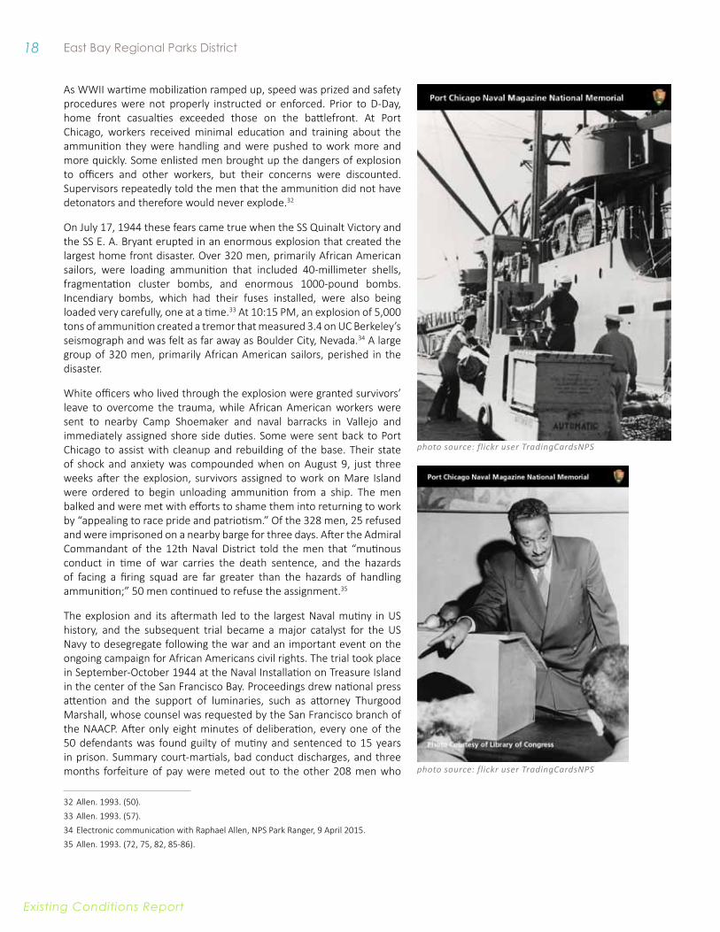
On July 17, 1944 these fears came true when the SS Quinalt Victory and the SS E. A. Bryant erupted in an enormous explosion that created the largest home front disaster. Over 320 men, primarily African American sailors, were loading ammunition that included 40-millimeter shells, fragmentation cluster bombs, and enormous 1000-pound bombs. Incendiary bombs, which had their fuses installed, were also being loaded very carefully, one at a time.33 At 10:15 PM, an explosion of 5,000 tons of ammunition created a tremor that measured 3.4 on UC Berkeley’s seismograph and was felt as far away as Boulder City, Nevada.34 A large group of 320 men, primarily African American sailors, perished in the disaster.
White officers who lived through the explosion were granted survivors’ leave to overcome the trauma, while African American workers were sent to nearby Camp Shoemaker and naval barracks in Vallejo and immediately assigned shore side duties. Some were sent back to Port Chicago to assist with cleanup and rebuilding of the base. Their state of shock and anxiety was compounded when on August 9, just three weeks after the explosion, survivors assigned to work on Mare Island were ordered to begin unloading ammunition from a ship. The men balked and were met with efforts to shame them into returning to work by “appealing to race pride and patriotism.” Of the 328 men, 25 refused and were imprisoned on a nearby barge for three days. After the Admiral Commandant of the 12th Naval District told the men that “mutinous conduct in time of war carries the death sentence, and the hazards of facing a firing squad are far greater than the hazards of handling ammunition;” 50 men continued to refuse the assignment.35
The explosion and its aftermath led to the largest Naval mutiny in US history, and the subsequent trial became a major catalyst for the US Navy to desegregate following the war and an important event on the ongoing campaign for African Americans civil rights. The trial took place in September-October 1944 at the Naval Installation on Treasure Island in the center of the San Francisco Bay. Proceedings drew national press attention and the support of luminaries, such as attorney Thurgood Marshall, whose counsel was requested by the San Francisco branch of the NAACP. After only eight minutes of deliberation, every one of the 50 defendants was found guilty of mutiny and sentenced to 15 years in prison. Summary court-martials, bad conduct discharges, and three months forfeiture of pay were meted out to the other 208 men who
32 Allen. 1993. (50).33 Allen. 1993. (57).34 Electronic communication with Raphael Allen, NPS Park Ranger, 9 April 2015.35 Allen. 1993. (72, 75, 82, 85-86).
photo source: flickr user TradingCardsNPS
photo source: flickr user TradingCardsNPS
19 Concord Hills Regional Park Land Use Plan
Existing conditions report
initially joined the work stoppage.36 An appeals campaign led by Marshall that lasted into 1945 was unsuccessful, though it drew widespread support from black leaders and newspapers across the country and even from Eleanor Roosevelt. It was not until after the war ended and the need to hand down heavy punitive examples diminished that the sentences were reduced to two and three years. In January 1946, 47 of the Port Chicago men were released from prison under orders of the Secretary of the Navy. One continued to be held for a bad conduct record, and two remained in the prison hospital for a time.37
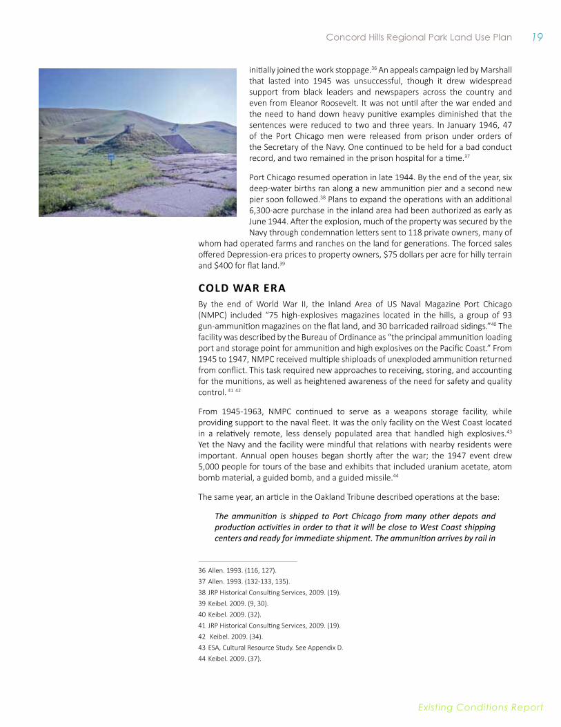
Port Chicago resumed operation in late 1944. By the end of the year, six deep-water births ran along a new ammunition pier and a second new pier soon followed.38 Plans to expand the operations with an additional 6,300-acre purchase in the inland area had been authorized as early as June 1944. After the explosion, much of the property was secured by the Navy through condemnation letters sent to 118 private owners, many of
whom had operated farms and ranches on the land for generations. The forced sales offered Depression-era prices to property owners, $75 dollars per acre for hilly terrain and $400 for flat land.39
Cold waR eRaBy the end of World War II, the Inland Area of US Naval Magazine Port Chicago (NMPC) included “75 high-explosives magazines located in the hills, a group of 93 gun-ammunition magazines on the flat land, and 30 barricaded railroad sidings.”40 The facility was described by the Bureau of Ordinance as “the principal ammunition loading port and storage point for ammunition and high explosives on the Pacific Coast.” From 1945 to 1947, NMPC received multiple shiploads of unexploded ammunition returned from conflict. This task required new approaches to receiving, storing, and accounting for the munitions, as well as heightened awareness of the need for safety and quality control. 41 42
From 1945-1963, NMPC continued to serve as a weapons storage facility, while providing support to the naval fleet. It was the only facility on the West Coast located in a relatively remote, less densely populated area that handled high explosives.43 Yet the Navy and the facility were mindful that relations with nearby residents were important. Annual open houses began shortly after the war; the 1947 event drew 5,000 people for tours of the base and exhibits that included uranium acetate, atom bomb material, a guided bomb, and a guided missile.44
The same year, an article in the Oakland Tribune described operations at the base:
The ammunition is shipped to Port Chicago from many other depots and production activities in order to that it will be close to West Coast shipping centers and ready for immediate shipment. The ammunition arrives by rail in
36 Allen. 1993. (116, 127).37 Allen. 1993. (132-133, 135).38 JRP Historical Consulting Services, 2009. (19).39 Keibel. 2009. (9, 30).40 Keibel. 2009. (32).41 JRP Historical Consulting Services, 2009. (19). 42 Keibel. 2009. (34).43 ESA, Cultural Resource Study. See Appendix D.44 Keibel. 2009. (37).
20 East Bay Regional Parks District
Existing conditions report
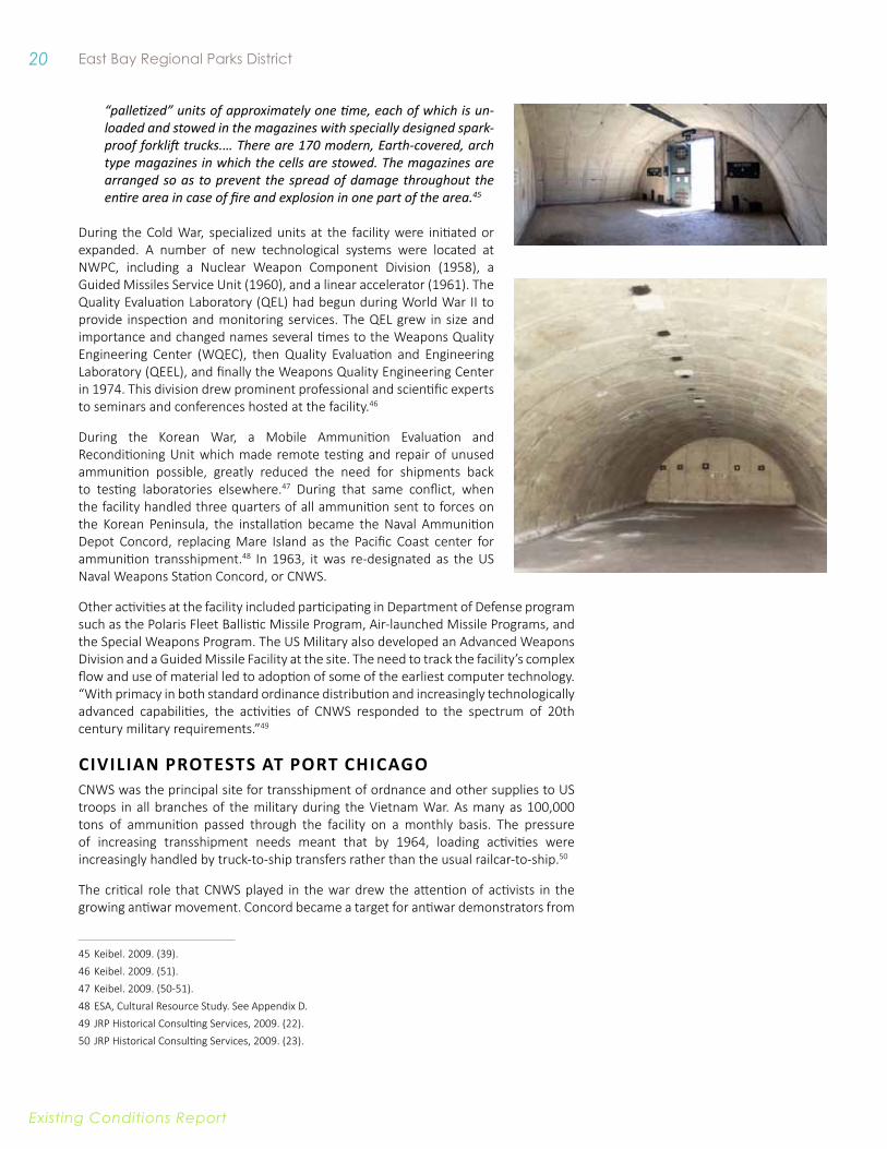
“palletized” units of approximately one time, each of which is un-loaded and stowed in the magazines with specially designed spark-proof forklift trucks.… There are 170 modern, Earth-covered, arch type magazines in which the cells are stowed. The magazines are arranged so as to prevent the spread of damage throughout the entire area in case of fire and explosion in one part of the area.45
During the Cold War, specialized units at the facility were initiated or expanded. A number of new technological systems were located at NWPC, including a Nuclear Weapon Component Division (1958), a Guided Missiles Service Unit (1960), and a linear accelerator (1961). The Quality Evaluation Laboratory (QEL) had begun during World War II to provide inspection and monitoring services. The QEL grew in size and importance and changed names several times to the Weapons Quality Engineering Center (WQEC), then Quality Evaluation and Engineering Laboratory (QEEL), and finally the Weapons Quality Engineering Center in 1974. This division drew prominent professional and scientific experts to seminars and conferences hosted at the facility.46
During the Korean War, a Mobile Ammunition Evaluation and Reconditioning Unit which made remote testing and repair of unused ammunition possible, greatly reduced the need for shipments back to testing laboratories elsewhere.47 During that same conflict, when the facility handled three quarters of all ammunition sent to forces on the Korean Peninsula, the installation became the Naval Ammunition Depot Concord, replacing Mare Island as the Pacific Coast center for ammunition transshipment.48 In 1963, it was re-designated as the US Naval Weapons Station Concord, or CNWS.
Other activities at the facility included participating in Department of Defense program such as the Polaris Fleet Ballistic Missile Program, Air-launched Missile Programs, and the Special Weapons Program. The US Military also developed an Advanced Weapons Division and a Guided Missile Facility at the site. The need to track the facility’s complex flow and use of material led to adoption of some of the earliest computer technology. “With primacy in both standard ordinance distribution and increasingly technologically advanced capabilities, the activities of CNWS responded to the spectrum of 20th century military requirements.”49
CiviliAN PROTeSTS AT PORT CHiCAGOCNWS was the principal site for transshipment of ordnance and other supplies to US troops in all branches of the military during the Vietnam War. As many as 100,000 tons of ammunition passed through the facility on a monthly basis. The pressure of increasing transshipment needs meant that by 1964, loading activities were increasingly handled by truck-to-ship transfers rather than the usual railcar-to-ship.50
The critical role that CNWS played in the war drew the attention of activists in the growing antiwar movement. Concord became a target for antiwar demonstrators from
45 Keibel. 2009. (39).46 Keibel. 2009. (51).47 Keibel. 2009. (50-51).48 ESA, Cultural Resource Study. See Appendix D.49 JRP Historical Consulting Services, 2009. (22).50 JRP Historical Consulting Services, 2009. (23).
21 Concord Hills Regional Park Land Use Plan
Existing conditions report
the region and across the United States, and their activities drew national attention. Peace protesters organized a daily vigil at the facility beginning on August 7, 1966. Actions at the site included picket lines at the gates and sit-ins in front of the trucks scheduled to deliver ammunition. Protesters reportedly faced frequent vitriol from CNWS employees and others and were even physically attacked. Yet their efforts drew attention and support from as far away as Sweden, and fundraising events held to support them boasted headliners such as Pete Seeger and Country Joe and the Fish. In 1967, the protest newsletter, Vigil Voices, described their purpose at Port Chicago: “We are deeply challenged by the obscenity of the truckloads and trainloads of death entering those narrow gates…Nowhere else in America is the cancer more apparent nor more vulnerable to an aroused people.”51
After the end of the Vietnam War, CNWS continued to draw outside scrutiny. It was the subject of a 1980 award-winning documentary film, Broken Arrow, which aired on public television. Investigative reporter Stephen Talbot claimed that the base had become a storage and transshipment site for nuclear weapons, which the Navy reportedly refused to confirm or deny. During the following decade, the facility drew another wave of protests as antiwar activists demonstrated against the shipment of arms to US-backed regimes in Nicaragua and El Salvador. The protestors saw their efforts as part of an international movement to end racism, American hegemony in what was then called the “Third World,” and the Reagan administration’s Central America interventions. A Handbook of Nonviolent Direct Action published by Pledge of Resistance drew explicit parallels between their work and the 1944 Port Chicago “mutiny” by African American sailors.52
Hundreds of protesters were arrested over many months, but the most dramatic event took place on September 1, 1987. On that date, Brian Willson, one of a group of Vietnam veteran protestors, was run over by a Navy train, which severed both of his legs at the knees.53 An article published the following year by Contra Costa Sheriff Richard K. Rainey pointed out that the previous nearly two years of daily demonstrations had drawn “little more than local attention.” After Willson was run over, “national and international media attention immediately focused on the protesters activity at the CNWS, and on the law enforcement response.” Four days after the event more than 5,000 demonstrators came to the facility, including the Rev. Jesse Jackson, singer Joan Baez and Rosario Murillo, wife of Nicaraguan President Daniel Ortega.54
51 Vigil Voices, (February 1967 and March 1976).52 Pledge of Resistance. “A Handbook of Non-Violent Direct Action.” 1987. (9).53 Allen. 1993. (146-47).54 Rainey, Richard K.. “The Cost of Protest: A Sheriff’s Perspective” California County. March 1988. (18).

22 East Bay Regional Parks District
Existing conditions report
TRANSfORMiNG CNWS iNTO PARklAND The Inland area of the CNWS was mothballed in 1999 due to changes in military operations, and the Inland area was officially approved for closure by the Base Closure and Realignment Commission (BRAC) in November of 2005. The planning processes that followed, and set the stage for the development of new regional park, are described in following section.
Cnws BasE REUsE PLannIng The mothballing and subsequent closure of the Inland area of the CNWS led to the development of several studies intended to guide future use of the Inland area. This section provides a brief timeline of planning efforts focused on the Inland area, and summarizes key documents as they relate as they relate to the development of the Regional Park Land Use Plan.
1999: CNWS mothballed due to changes in military operations; preliminary study of potential joint uses conducted.
2002: Navy and City of Concord initiate discussions on City’s acquisition of property for park development. City prepares draft master plan for 154-acre area, but project shelved following announcement of potential base closure.
2005: Inland area of the CNWS approved for closure by the Base Closure and Realignment Commission (BRAC); Concord City Council designated as Local Reuse Authority (LRA).
2006-2010: City develops Concord Community Reuse Plan with significant community input. Community engagement included a 21- member Community Advisory Committee, and public workshops in 2007 and 2008 to provide input on development and refinement of alternative concepts. In winter, 2008, the LRA designated the Clustered Village Alternative as the Preferred Alternative. In winter 2010, the EIR was certified and the Reuse Plan was adopted by the Concord City Council.
2010: The Draft Concord Reuse Project Area Plan (Area Plan) was issued for community consideration.
2012: Area Plan adopted by Concord City Council and incorporated into General Plan.
2015: East Bay Regional Park District initiates development of a Park Use Plan to further guide regional park development.
It is important to note that the Tidal Area of the former CNWS, which contains the Port Chicago Naval Magazine National Memorial was transferred to the Army following base closure, and is not within the Area Plan. This area includes the Military Ocean Terminal Concord (MOTCO), and therefore the Port Chicago Naval Magazine National Memorial.
23 Concord Hills Regional Park Land Use Plan
Existing conditions report
POTeNTiAl JOiNT uSe STuDy (2000) AND RelATeD Planning eFFoRTSCongressman George Miller facilitated a joint use study to identify potential uses for the Inland area of the CNWS in late 1999, after the area was mothballed by the Navy. A list of potential joint use concepts, focusing on recreation and open space use, was generated by the study and provided to the Navy in 2000. While the study was favorably received, the events of September 11, 2001 led to a revision of security operations that reduced potential use areas to a 154-acre area of the CNWS that borders Willow Pass Road and Olivera Road.
This 154-acre area for potential joint use was identified as a potential park site by City of Concord officials. By the end of 2002, the City and Navy had developed a conceptual lease agreement for the development of a City park and the City had initiated development of a draft Master Plan for this area. This process was halted upon announcement by the Department of Defense that a number of bases would be closed.
CONCORD COMMuNiTy ReuSe PlAN AND eiRThe City of Concord, acting as the Local Reuse Authority, prepared the Concord Community Reuse Plan (Reuse Plan) to guide the future development of the former CNWS. The planning process was guided by substantial public involvement, including a Community Advisory Committee that consisted of 21 community members representing a broad and balanced cross-section of the community, as well as public workshops in 2007 and 2008.
photo credit: Stephen Joseph Fine Art Photography
24 East Bay Regional Parks District
Existing conditions report
Key outcomes of the planning process are described below and include the development of a Planning Framework that would guide the development of the Reuse Plan and Area Plan (described below), as well as a preferred alternative concept for the Reuse Area.
PlANNiNG fRAMeWORkThe Planning Framework developed by the City Council with input from the community includes the following overarching goals:
• World-class Project.
• A Balanced Approach.
• Economically Viable and Sustainable Development.
• Quality of Life.
The goals are supported by a series of goals and guiding principles specific to the following topic areas: planning considerations; community development; parks, recreation, and open space; economic development; and transportation. Goals and principles related to parks, recreation, and open space, are particularly pertinent and are provided below.
PARkS, ReCReATiON AND OPeN SPACe (PR) GOAlSPR-A: ReSOuRCe CONSeRvATiON
» Ensure that natural, cultural and historic resources are preserved for the long-term benefit of the ecosystem and for appreciation and understanding of current residents and future generations.
» Recognize the value of the natural environment.
» Promote conservation and education as a community benefit.
PR-B: lAND STeWARDSHiP » Recognize the value of the natural environment and
take a leadership role in sustainable land management practices.
PR-C: COMMuNiTy PARkS AND ReCReATiON » Meet the long-term park and recreation needs of the
community.
GuiDiNG PRiNCiPleS PR-1: MAxiMiziNG OPeN SPACe
» Provide parks and open space to serve Concord residents and the region. Ensure that there are large, contiguous and usable open space elements in the Community Reuse Project.
» Protect significant views and viewsheds.
PR-2: WATeRSHeD APPROACH » Apply a watershed approach for preserving, restoring
and enhancing the natural resources and open space on the Weapons Station.
» Address water quality, wildlife corridors and buffers, habitat protection, flood control, recreation and open space designation.
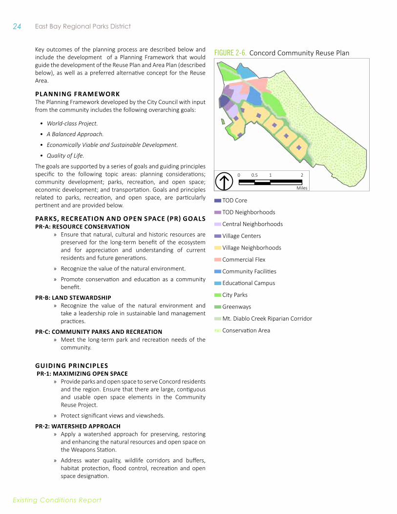
Figure 2-6. Concord Community Reuse Plan
0 1 20.5
Miles
TOD Core
TOD Neighborhoods
Central Neighborhoods
Village Centers
Village Neighborhoods
Commercial Flex
Community Facilities
Educational Campus
City Parks
Greenways
Mt. Diablo Creek Riparian Corridor
Conservation Area
25 Concord Hills Regional Park Land Use Plan
Existing conditions report
PR-3: ReGiONAl CONNeCTiviTy » Explore possibilities for connecting to other regional and local parks and trails
to provide a comprehensive system of habitat, open space and recreation areas.
PR-4: HABiTAT MANAGeMeNT » Provide for the integration of preservation, enhancement and management
of identified habitats and related species with other uses.
PR-5: vARieTy Of PARkS AND ReCReATiONAl fACiliTieS » Provide a variety of parks and recreation elements, including regional and
neighborhood parks, trails, and outdoor recreation.
» Address sports and recreation needs in Concord, including regional-scale, lighted or multi-purpose sports facilities, community centers, and cultural and performing-arts facilities.
» Ensure that facilities and amenities include opportunities for older adults and people with disabilities.
PRefeRReD AlTeRNATive fuTuRe SCeNARiO The goals and principles included in the Planning Framework guided the development of seven alternatives that described potential future scenario. All alternatives included preservation of hillsides, a riparian corridor along Mt. Diablo Creek, and connections between the community and the regional park, among other features. Variations explored in the alternatives included the distribution and location of residential, commercial, and public facilities, and other uses.
26 East Bay Regional Parks District
Existing conditions report
In winter, 2008, the Concord City Council, acting as LRA, designated the alternative referred to as the Clustered Village Alternative as the Preferred Alternative, and the Reuse Plan was prepared based on this alternative. In winter 2010, an EIR assessing potential impacts of the Reuse Plan was certified and the Reuse Plan was adopted by the City Council.
CONCORD ReuSe PROJeCT AReA PlAN The Concord Reuse Project Area Plan (Area Plan) and consistency amendments to the Concord 2030 General Plan were prepared following adoption of the Reuse Plan. The Area Plan is based on the Reuse Plan, but provides specific policies and development standards to ensure realization of the vision identified within the Reuse Plan.
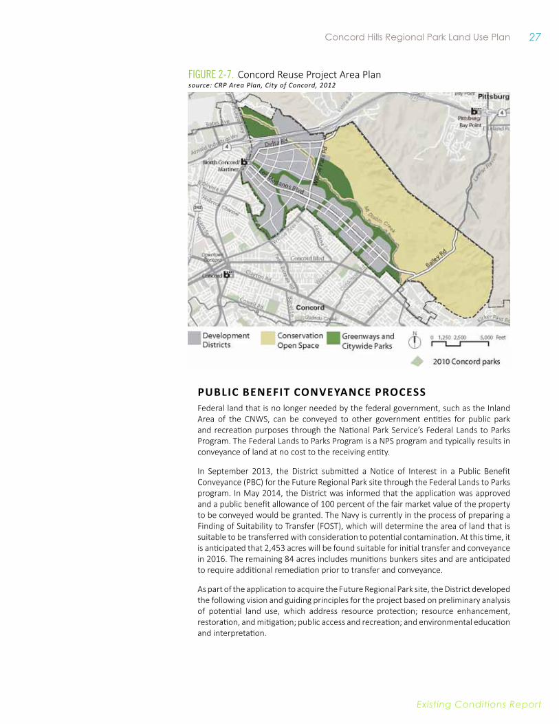
The Area Plan involves development of over 12,200 new housing units, over 6.1 million square feet of commercial floor space, and a variety of community facilities and city parks. As described in Chapter 1, the proposed community development under the Area Plan would primarily be clustered on the western portion of the former base. Highlights of the new community include:
• A transit-oriented district with the flavor of city life.
• Neighborhoods of character and convenience.
• A commercial district offering flexibility and opportunity for investment and job growth.
• Open spaces that provide for conservation and recreation.
• Community and regional facilities.
• Action on climate change.
• Convenient multi-modal transportation system.
The regional park occupies the eastern portion of the Plan Area and is identified for resource conservation and low impact recreation with East Bay Regional Park District as the anticipated long-term owner and manager. Aspects of the Area Plan that are relevant to the Future Regional Park include but are not limited to:
• Emphasis on habitat conservation, low impact recreation for the regional park, and preservation of hillside views and views of Mount Diablo.
• Regional trail and open space connections and strong connectivity between the future development and regional park, with convenient access for residents living within the Plan Area and BART riders.
• Restoration of Mount Diablo Creek and the establishment of conservation buf-fers on either side of the creek. Conservation measures and features within the regional park and Mount Diablo Creek will be determined based upon permit re-quirements from State and federal resource management agencies.
• Circulation system with three through-roads connecting to or through the region-al park, including Bailey Road, Willow Pass Road, and the future Delta Road.
• City parks and greenways are identified for the EDC area, including parkland that will be immediately adjacent to the Future Regional Park.
The development of the Future Regional Park is linked to the phasing and implementation of the encompassing Area Plan. Connections between the development of the EDC area and the PBC area include but are not limited to trail and road connections, utility connections, habitat development, and conservation mitigation. Furthermore, recreational opportunities provided within city parkland will inform the types of opportunities appropriate for the regional park.
27 Concord Hills Regional Park Land Use Plan
Existing conditions report
PuBliC BeNefiT CONveyANCe PROCeSSFederal land that is no longer needed by the federal government, such as the Inland Area of the CNWS, can be conveyed to other government entities for public park and recreation purposes through the National Park Service’s Federal Lands to Parks Program. The Federal Lands to Parks Program is a NPS program and typically results in conveyance of land at no cost to the receiving entity.
In September 2013, the District submitted a Notice of Interest in a Public Benefit Conveyance (PBC) for the Future Regional Park site through the Federal Lands to Parks program. In May 2014, the District was informed that the application was approved and a public benefit allowance of 100 percent of the fair market value of the property to be conveyed would be granted. The Navy is currently in the process of preparing a Finding of Suitability to Transfer (FOST), which will determine the area of land that is suitable to be transferred with consideration to potential contamination. At this time, it is anticipated that 2,453 acres will be found suitable for initial transfer and conveyance in 2016. The remaining 84 acres includes munitions bunkers sites and are anticipated to require additional remediation prior to transfer and conveyance.
As part of the application to acquire the Future Regional Park site, the District developed the following vision and guiding principles for the project based on preliminary analysis of potential land use, which address resource protection; resource enhancement, restoration, and mitigation; public access and recreation; and environmental education and interpretation.
Figure 2-7. Concord Reuse Project Area Plansource: CRP Area Plan, City of Concord, 2012
28 East Bay Regional Parks District
Existing conditions report
1. Resource Protection – The District will work closely with the City, State, and federal resource agencies; project developers; and other stakeholders to ensure the protection of critical natural and cultural resources found on the CNWS.
» Establish appropriate Resource Protection Zones in areas of sensitive resources, protected wetlands, and known cultural sites;
» Develop long-term resource management plans focused on resource protection and enhancement while preserving public access opportunities.
2. Resource enhancement, Restoration, and Mitigation – The District will proactively engage project developers and State and federal resource agencies to identify lands appropriate for resource enhancement and restoration and provide for required mitigation for proposed development on the CNWS site.
» Develop extensive tree replanting program where appropriate and consistent with habitat requirements;
» Facilitate restoration of Mount Diablo Creek, wetlands, and other sensitive habitats with City of Concord, project developers, and regional stakeholders;
» Facilitate on-site mitigation for loss of sensitive habitats, wetlands, and impacts to species from proposed development elsewhere on the CNWS site in coordination with State and federal resource agencies, the City of Concord, and project developers.
3. Public Access and Recreation – The District will work diligently to ensure that resource protection and enhancement programs are balanced with the need to provide for public access and recreation throughout the CNWS site.
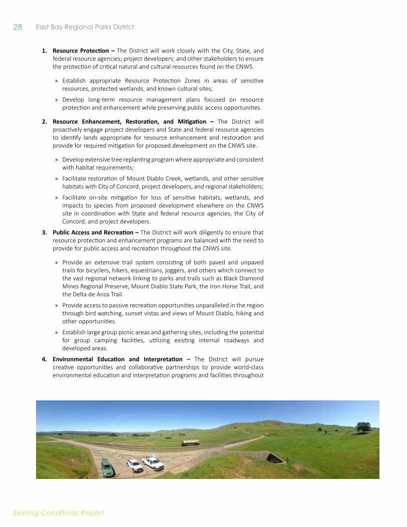
» Provide an extensive trail system consisting of both paved and unpaved trails for bicyclers, hikers, equestrians, joggers, and others which connect to the vast regional network linking to parks and trails such as Black Diamond Mines Regional Preserve, Mount Diablo State Park, the Iron Horse Trail, and the Delta de Anza Trail.
» Provide access to passive recreation opportunities unparalleled in the region through bird watching, sunset vistas and views of Mount Diablo, hiking and other opportunities.
» Establish large group picnic areas and gathering sites, including the potential for group camping facilities, utilizing existing internal roadways and developed areas.
4. environmental education and interpretation – The District will pursue creative opportunities and collaborative partnerships to provide world-class environmental education and interpretation programs and facilities throughout
29 Concord Hills Regional Park Land Use Plan
Existing conditions report
the CNWS to preserve and share the unique natural, cultural, social, and military history of the CNWS and the Central Contra Costa County region.
» Provide for an environmental day camp and education center geared towards educating the region’s youth about the area’s natural and cultural history.
» Establish a world-class historical interpretation and visitors center in partnership with the National Park Service, Friends of Port Chicago, and others which honors the veterans who served on the CNWS property, conveys the significance of the events at Port Chicago, provides displays on the history of Concord and the Diablo Valley region, and provides a staging area to facilitate access to the National Park Service’s Port Chicago Memorial.
CNWS Base Reuse Planning documents that inform the Regional Park Land Use Plan planning process include:
• Concord Community Reuse Area Plan.
• Concord Community Reuse Project Final Environmental Impact Report (FEIR), Ad-dendum, Mitigation Monitoring and Reporting Plan, and associated technical re-ports.
• Draft Environmental Impact Statement (EIS) for the Disposal and Reuse of Former Naval Weapons Station Seal Beach, Detachment Concord, and associated techni-cal reports.
• PBC Application.
PARTNeRSHiP BeTWeeN DiSTRiCT AND NPSAs discussed in Chapter 1, NPS was authorized by provisions in H.R. 2647 (2009) to work in partnership with the City of Concord and the District towards a jointly-operated visitor facility that would allow the Port Chicago story to be shared more broadly. This partnership has facilitated the Public Benefit Conveyance process (described above), and will continue to be beneficial and influential to the planning process.
The District and NPS signed a Cooperative Management Agreement that formalizes their partnership and further guides collaboration during the planning, design, and operation of the Future Regional Park. The Agreement identifies specific roles of the District and NPS, including that the District will lead the Land Use Planning process and serve as the lead agency for the joint visitor facility. However, both entities will provide staffing and support for the facility. The Agreement also identifies several areas for collaboration:
• Collaborate in the development of the Concord Hills Regional Park Land Use Plan, including the preliminary planning and design for a Port Chicago Naval Magazine National Memorial Visitor Center as part of this larger planning process.
• Collaborate in the design, production, and placement of interpretive displays and materials concerning the Port Chicago Naval Magazine National Memorial.
• Collaborate in the planning and implementation of the annual Port Chicago me-morial event.
• Work collaboratively with other community groups to advance the planning, de-sign, and interpretation of the Concord Hills Regional Park and Port Chicago Naval Magazine National Memorial.
30 East Bay Regional Parks District
Existing conditions report
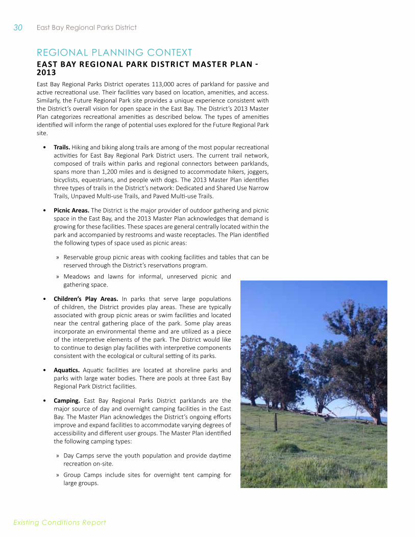
REgIonaL PLannIng ContExteAST BAy ReGiONAl PARk DiSTRiCT MASTeR PlAN - 2013East Bay Regional Parks District operates 113,000 acres of parkland for passive and active recreational use. Their facilities vary based on location, amenities, and access. Similarly, the Future Regional Park site provides a unique experience consistent with the District’s overall vision for open space in the East Bay. The District’s 2013 Master Plan categorizes recreational amenities as described below. The types of amenities identified will inform the range of potential uses explored for the Future Regional Park site.
• Trails. Hiking and biking along trails are among of the most popular recreational activities for East Bay Regional Park District users. The current trail network, composed of trails within parks and regional connectors between parklands, spans more than 1,200 miles and is designed to accommodate hikers, joggers, bicyclists, equestrians, and people with dogs. The 2013 Master Plan identifies three types of trails in the District’s network: Dedicated and Shared Use Narrow Trails, Unpaved Multi-use Trails, and Paved Multi-use Trails.
• Picnic areas. The District is the major provider of outdoor gathering and picnic space in the East Bay, and the 2013 Master Plan acknowledges that demand is growing for these facilities. These spaces are general centrally located within the park and accompanied by restrooms and waste receptacles. The Plan identified the following types of space used as picnic areas:
» Reservable group picnic areas with cooking facilities and tables that can be reserved through the District’s reservations program.
» Meadows and lawns for informal, unreserved picnic and gathering space.
• Children’s Play Areas. In parks that serve large populations of children, the District provides play areas. These are typically associated with group picnic areas or swim facilities and located near the central gathering place of the park. Some play areas incorporate an environmental theme and are utilized as a piece of the interpretive elements of the park. The District would like to continue to design play facilities with interpretive components consistent with the ecological or cultural setting of its parks.
• Aquatics. Aquatic facilities are located at shoreline parks and parks with large water bodies. There are pools at three East Bay Regional Park District facilities.
• Camping. East Bay Regional Parks District parklands are the major source of day and overnight camping facilities in the East Bay. The Master Plan acknowledges the District’s ongoing efforts improve and expand facilities to accommodate varying degrees of accessibility and different user groups. The Master Plan identified the following camping types:
» Day Camps serve the youth population and provide daytime recreation on-site.
» Group Camps include sites for overnight tent camping for large groups.
31 Concord Hills Regional Park Land Use Plan
Existing conditions report
» Backpack Camps are located along trails and provide space for overnight tent camping to accommodate multi-day trail use.
» Family Camps provide sites for overnight car-camping, as well as RV use.
» Residential Camps are large facilities that provide overnight camping and recreational activities for youth or large adult retreat groups. The District currently owns Camp Arroyo in Livermore,, which is the only Residential Camp in the District.
» Hostels are indoor facilities providing minimal accommodations. The District does not currently operate any hostel facilities.
• Special facilities. Within the District’s parklands, there are numerous special facilities that create an iconic experience for park visitors and amenities that provide a unique recreational opportunity. Within the current park system, this includes: “equestrian centers; a boating center; meeting and conference areas; a botanical garden; golf courses; archery and marksmanship ranges; a hang gliding area; model boat and train areas; a historic merry-go-round; and two historic farms.” Typically, these facilities are remnants from a previous use of the property. The Master Plan points out that while these facilities must be consistent with the District’s overall vision and mission, they can help to provide a distinctive recreational, economic, and cultural destination.
CONTRA COSTA COuNTy GeNeRAl PlAN The Contra Costa County General Plan, adopted in 2005, contains broad goals and policies, and specific implementation measures, to guide decisions on future growth, development, and the conservation of resources through the year 2020. The General Plan has a number of policies that address the preservation of open space resources, including historic, cultural, natural, and scenic resources. The General Plan also includes policies related to the development of park and recreational facilities, including trails. The Future Regional Park site is within the city limit of Concord and does not fall within the jurisdiction of the Contra Costa County General Plan. However, regional trail connections between the Future Regional Park site and Black Diamond Mines Regional Preserve and Mount Diablo State Park to the east, would involve cooperation with Contra Costa County, and any development should conform to these policies.
eAST CONTRA COSTA COuNTy HABiTAT ConSeRvaTion Plan The East Contra Costa County Habitat Conservation Plan/Natural Community Conservation Plan (HCP/NCCP) provides an effective framework to protect natural resources in eastern Contra Costa County, while improving and streamlining the environmental permitting process for impacts on endangered species. The intent of the HCP is to avoid project-by-project permitting that is generally costly and time consuming for applicants and often results in uncoordinated and biologically ineffective mitigation. Specifically, the Plan aims to protect and enhance ecological diversity and function within the rapidly urbanizing region of eastern Contra Costa County. To that end, the Plan describes how to avoid, minimize, and mitigate, to the maximum extent possible, impacts on covered species and their habitats and wetlands while allowing for the growth of selected regions of the County.
One of the primary goals of the HCP is to acquire land, either through a fee title or through establishment of conservation easements. To develop priorities and identify potential locations for land acquisition, the HCP area was subdivided geographically into six Acquisition Analysis Zones (Zones). Zones were further divided into Subzones
32 East Bay Regional Parks District
Existing conditions report
to distinguish between important landscape features. Acquisition priorities for each Zone were developed primarily on the basis of the ecological opportunities and constraints for collectively achieving the biological goals and objectives for covered species, natural communities, and landscapes. Zone 2 covers the key habitat linkages between Cowell Ranch/Los Vaqueros in the east and Black Diamond Mines Regional Preserve and the Concord Naval Weapons Station in the west. Although the Future Regional Park site falls outside of the boundaries of the HCP, its geographic relationship to areas that are covered by the HCP are important to consider in development and implementation of the Land Use Plan (LUP) and its connections to other nearby areas.
CONTRA COSTA COuNTy BiCyCle AND PeDeSTRiAN PlanContra Costa County has identified a number of proposed multi-use trails in and around the project area, including additional Class I and Class III trails with off-street and on-street facilities. The Contra Costa Countywide Bicycle and Pedestrian Plan provides policy and infrastructure recommendations to improve bicycle and pedestrian facilities throughout the region.55 Contra Costa County has several Class I trails in the Future Regional Park site, including the Contra Costa Canal Trail and the Iron Horse Trail, and Class II Bicycle Lane and Class III Bicycle Route facilities.
The Future Regional Park site is located within the City of Concord, which will be overseeing the development of the Concord Reuse Plan. The Future Regional Park site can be a resource to other planning efforts from the City.
CiTy Of CONCORD 2030 GeNeRAl PlAN The Parks, Open Space, and Conservation Element of the City of Concord 2030 General Plan is intended to provide guidance for preservation of the City’s open spaces and other natural resources, and identifies park and recreation facilities available to local residents. The General Plan contains a list of 22 neighborhood and community parks and specialized recreation facilities and identifies approximately 12,743 acres of open space within the General Plan Area. Significant open spaces within the Planning Area include: Lime Ridge Open Space, the Mount Diablo Foothills, and the area north of Mallard Reservoir that is designated Wetlands/Resource Conservation.
The General Plan identifies the Future Regional Park site - part of what the General Plan refers to as the Concord Reuse Project (CRP) site - as a significant open space resource. Because the Future Regional Park site falls within the open space areas regulated by the City of Concord 2030 General Plan, the LUP must comply with all principles, policies, and implementation measures that are applicable to the LUP and its implementation. These policies relate not only to the recreational uses of the Future Regional Park site but also to the protection of its biological resources and cultural resources (historic structures and archaeological sites). Some of the most directly relevant policies are listed below:
Policy POS-1.2.1: Implement strategies and actions associated with the design, development, and operation of multi-purpose trails as contained in the Trails Master Plan.
Policy POS-1.2.2: Work with proposed development projects to provide new linkages to existing trails and create new trails where feasible.
Policy POS-2.1.1: Acquire, preserve, and maintain open space for future generations.
55 Contra Costa County, 2009.
33 Concord Hills Regional Park Land Use Plan
Existing conditions report
Policy POS-2.1.4: Incorporate portions of the Concord Reuse Project site into the regional open space network, and provide trail and greenway connections between this area and developed Concord neighborhoods.
Policy POS-2.2.1: Design structures and facilities located within parks and open space areas to complement the natural setting and values of each site and adjacent lands.
Policy POS-2.2.5: Require degraded open space areas to be restored to an environmentally sustainable condition as part of development approval where these lands are proposed as permanent open space in new development.
Policy POS-2.3.1: Increase the regional trail, ridgeline, and hillside open space system in the City’s Planning Area through joint efforts with East Bay Regional Park District, Contra Costa County, the U.S. Government, and nonprofit trustee agencies.
Policy POS-3.1.2: Preserve and restore native riparian vegetation and wildlife, and establish riparian corridors along all creeks.
Policy POS-3.2.3: For wetlands that are not adjacent to Suisun Bay, follow management and protection measures that are consistent with State and federal requirements.
A number of small wetland areas exist on the Concord Reuse Project (CRP) site. The CRP Area Plan generally conserves these areas as open space, although conservation may not be feasible in all instances. In such cases, mitigation measures have been prescribed to establish replacement wetlands elsewhere.
Policy POS-3.4.1: Conserve wildlife habitat and wildlife corridors, including seasonal migration routes, and require appropriate mitigation in the event such areas are impacted by development.
Policy POS-3.4.2: Protect rare, threatened, or endangered species and their habitats through the environmental review process and in accordance with State and Federal law.
Policy POS-3.6.2: Require that future design and construction on the Concord Reuse Project Site incorporates sustainable development principles, including green building, green infrastructure, site planning which maximizes solar access opportunities, and a land use and transportation plan which maximizes opportunities for non-automobile travel.
Policy POS-4.1.1: Preserve all City, State, and federally designated historic sites and structures to the maximum extent feasible.
CiTy Of CONCORD TRAilS MASTeR PlANThe Concord Trails Master Plan provides a framework for planning trails in Concord with the purpose of promoting the use of trails for recreation as well as an alternative mode of transportation.56 The Trails Master Plan includes recommended trail alignments and design guidelines, and identifies several potential trail routes, including a connection to the Delta De Anza Trail and Class I collector trails that follow either rail lines or creeks that run through the site. The Concord 2030 General Plan includes an Implementation Action to “[r]eview, update, and implement [the] Trails Master Plan.”
56 City of Concord, 2002.
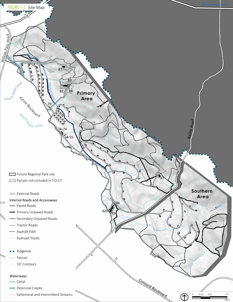
34 East Bay Regional Parks District
Existing conditions report
93
81
87
97
IA-24
79
94
83
IA-55
84
420
Baile
y Ro
ad
Will
ow P
ass R
oad
4
Concord Boulevard
Mount Di a b lo Creek
Con t r a C
osta
Cana l Cl ay ton Canal
Contra Costa Canal
Kinne Bouleva rd
Southern Area
Primary Area
0 0.25 0.50.125
Miles
Canal
Ephemeral and Intermittent Streams
Perennial Creeks
Waterways
Tractor Roads
Secondary Unpaved Roads
Primary Unpaved Roads
Asphalt Path
Ridgeline
Fences
Paved RoadsInternal Roads and Accessways
Railroad Tracks
External Roads
10’ Contours
Future Regional Park site
Parcels not included in F.O.S.T.
Figure 3-1. Site Map
35
East bay regional parks district concord Hills regional park Land Use plan
Existing Conditions Report
3. tHE fUtURE REgIonaL PaRk sItE The Future Regional Park site is comprised of diverse resources and infrastructure. This section provides a summary of these existing conditions and current site uses and activities, and identifies key implications for the development of the Future Regional Park site. Information is based on review of background documents, fieldwork and studies conducted as part of the planning process, and conversations with District staff. A summary of key opportunities and constraints is provided in Chapter Five.
ExIstIng REsoURCEsThe expanse of the 2,537 acre Future Regional Park site contains a wealth of resources that will inform the development of the Future Regional Park site. This section focuses on hydrologic, biological, and cultural resources.
TOPOGRAPHy AND SOilS Site topography consists primarily of gently sloping lowlands along a valley plain with the steeper south-facing Los Medanos Hills along the eastern boundary. Elevations at the Future Regional Park site range from about 100 feet above sea level in the northwestern portion of the site to 1,000 feet above sea level along the ridgeline. Mount Diablo Creek runs just outside of the western boundary of the Future Regional Park site and has a low point of 14 feet above sea level. The Clayton section of the Greenville Fault Zone runs northwest to southeast through the eastern portion of the Future Regional Park site.
The Future Regional Park site’s dramatic topography directly influenced previous development patterns on the site. The hillside areas have remained less developed due to the challenges inherent in hillside development, and extensive networks of roads and building sites were developed in the flatter areas.
In addition to the natural topography of the Future Regional Park site, munitions storage on-site led to significant modification to the landscape. Manufactured topography in the form of buried magazines and rail line embankments are also key topographical references on-site. Magazines were constructed in the flat areas and included concrete walls completely covered with soil and planted with grass, resulting in large berms along the valley floor reaching approximately 15 feet in height. Magazines were served by rail lines which typically built up on rock above the native ground to achieve a gentle slope, creating a network of embankments around the magazine areas.
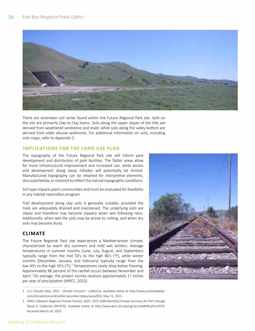
36 East Bay Regional Parks District
Existing conditions report
There are seventeen soil series found within the Future Regional Park site. Soils on the site are primarily Clay to Clay loams. Soils along the upper slopes of the hills are derived from weathered sandstone and shale; while soils along the valley bottom are derived from older alluvial sediments. For additional information on soils, including soils maps, refer to Appendix C.
iMPliCATiONS fOR THe lAND uSe PlANThe topography of the Future Regional Park site will inform park development and distribution of park facilities. The flatter areas allow for more infrastructural improvement and increased use, while access and development along steep hillsides will potentially be limited. Manufactured topography can be retained for interpretive elements, discussed below, or restored to reflect the natural topographic conditions.
Soil type impacts plant communities and must be evaluated for feasibility in any habitat restoration program.
Trail development along clay soils is generally suitable, provided the trails are adequately drained and maintained. The underlying soils are clayey and therefore may become slippery when wet following rains. Additionally, when wet the soils may be prone to rutting, and when dry soils may become dusty.
CliMATeThe Future Regional Park site experiences a Mediterranean climate, characterized by warm dry summers and mild wet winters. Average temperatures in summer months (June, July, August, and September) typically range from the mid 50’s to the high 80’s (°F), while winter months (December, January, and February) typically range from the low 40’s to the high 50’s (°F).1 Temperatures rarely drop below freezing. Approximately 86 percent of the rainfall occurs between November and April.2 On average, the project vicinity receives approximately 17 inches per year of precipitation (WRCC, 2015).
1 U.S. Climate Data, 2015. Climate Concord – California. Available online at http://www.usclimatedata.com/climate/concord/california/united-states/usca2033. May 11, 2015.
2 WRCC (Western Regional Climate Center), 2015. 1971-2000 Monthly Climate Summary for Port Chicago Naval D, California (047070). Available online at http://www.wrcc.dri.edu/cgi-bin/cliMAIN.pl?ca7070. Accessed March 10, 2015.

37 Concord Hills Regional Park Land Use Plan
Existing conditions report
iMPliCATiONS fOR THe lAND uSe PlANRainfall patterns dramatically impact the visual condition of the Future Regional Park site, with the wet winters being characterized with green grasses while the dry months are characterized by golden hillsides. Wet winters can also produce dramatic wildflower displays in the spring, which could be a potential draw for park users.
Hot summer months may impede some park users, particularly elderly or young visitors. Exposed trail routes should be minimal and provide shade respite and water opportunities where possible. Additionally, climatic conditions should be well identified in the areas with high visitor use so visitors are made aware of potentially extreme conditions.
WATeR ReSOuRCeS3
The Future Regional Park site is within the 23,800-acre Mount Diablo Creek Watershed, although a small portion of the eastern boundary of the Future Regional Park site drains east to the Willow Creek watershed, towards the City of Pittsburg. The headwaters of Mount Diablo Creek watershed are located on the northern face of Mount Diablo, and from there water flows north-northwest through the watershed to wetlands on the south border of Suisun Bay. The majority of the watershed area (54 percent), mostly located upstream of the Future Regional Park site, is land managed as open space or agriculture.
HiSTORiC eCOlOGy Of MOuNT DiABlO WATeRSHeDBy the mid-nineteenth century mining and agriculture activities were significantly impacting ecological processes and tapping natural resources. Historical studies suggest that this was the beginning of the modification of local water systems and the early transformation of Mount Diablo Creek.4 Historical maps suggest that Mount Diablo Creek changed to its current alignment sometime between 1885 and 1915. Earlier maps show the creek flowing along the edge of present day Concord Naval Weapon Station then heading west to Pacheco Slough while a separate creek, Seal Creek, ran along the east side of the Los Medanos hills.
By 1898, Mount Diablo Creek was likely in its present location, east of its earlier alignment and within the historic watershed of Seal Creek. Today, the Clayton Valley Drain seems to follow more closely the historical alignment of Mount Diablo Creek. The precise reason for the realignment is unknown, but it was likely to divert water for agriculture or quarry use. Aerial photography from 1938 suggests that Mount Diablo Creek was already heavily incised at that time and that the creek, “has not moved or widened substantially” since that time.5 With a deeply-eroded channel, progressively larger flood flows are confined to the channel instead of spilling out onto the surrounding floodplain. This process leads to further erosion, deepening the channel relative to the surrounding topography and undermining the channel banks. As a result of the deep incision, as much as 25 feet below the top of bank in places, of Mount Diablo Creek, there is very little active floodplain adjacent to the channel.
3 Information in this section is based on the Hydrology and Water Quality Study written by Environmental Science Associates (ESA), included in Appendix B.
4 Cain, John and Rich Walking. “Mount Diablo Creek Watershed Inventory Final Report: Appendix 1.” Contra Costa Resource Conservation District. Clayton, CA. June 30 2006.
5 Cain and Walking, 2006.
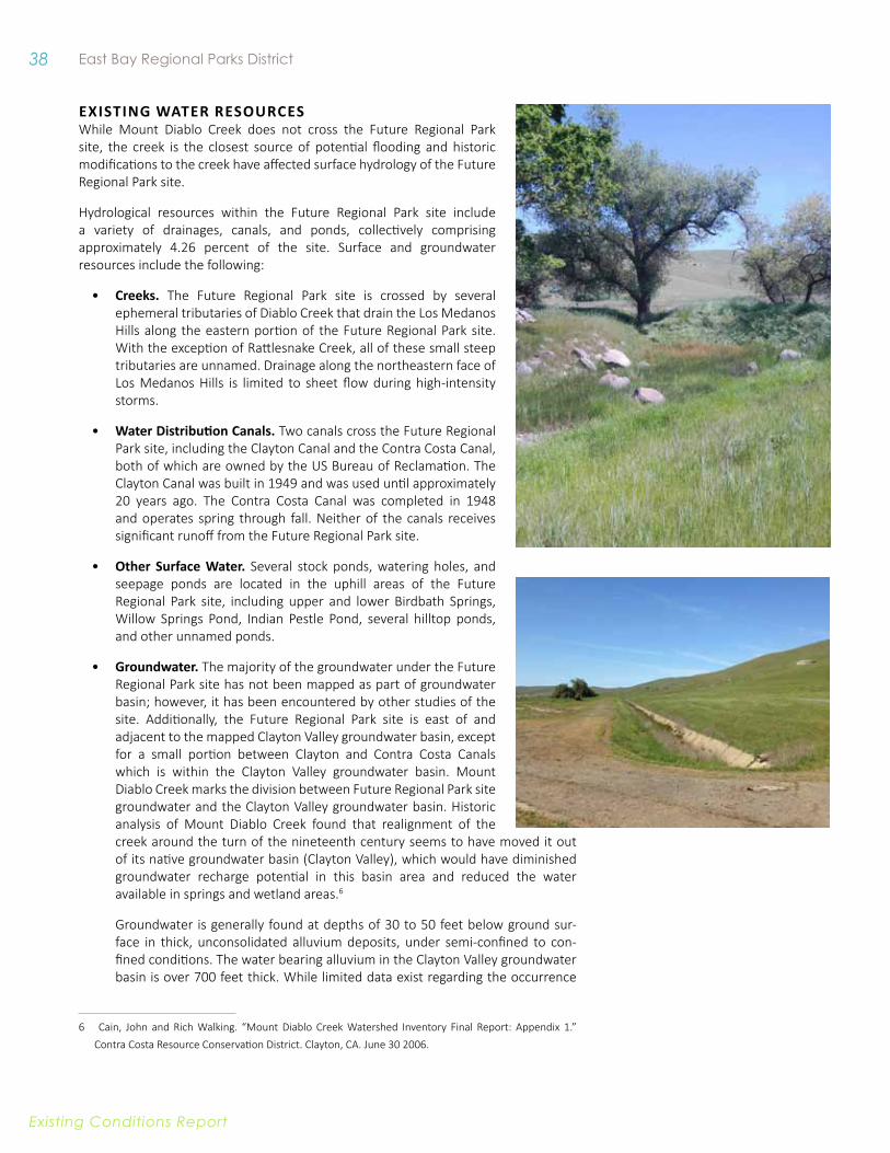
38 East Bay Regional Parks District
Existing conditions report
exiSTiNG WATeR ReSOuRCeSWhile Mount Diablo Creek does not cross the Future Regional Park site, the creek is the closest source of potential flooding and historic modifications to the creek have affected surface hydrology of the Future Regional Park site.
Hydrological resources within the Future Regional Park site include a variety of drainages, canals, and ponds, collectively comprising approximately 4.26 percent of the site. Surface and groundwater resources include the following:
• Creeks. The Future Regional Park site is crossed by several ephemeral tributaries of Diablo Creek that drain the Los Medanos Hills along the eastern portion of the Future Regional Park site. With the exception of Rattlesnake Creek, all of these small steep tributaries are unnamed. Drainage along the northeastern face of Los Medanos Hills is limited to sheet flow during high-intensity storms.
• Water Distribution Canals. Two canals cross the Future Regional Park site, including the Clayton Canal and the Contra Costa Canal, both of which are owned by the US Bureau of Reclamation. The Clayton Canal was built in 1949 and was used until approximately 20 years ago. The Contra Costa Canal was completed in 1948 and operates spring through fall. Neither of the canals receives significant runoff from the Future Regional Park site.
• other Surface water. Several stock ponds, watering holes, and seepage ponds are located in the uphill areas of the Future Regional Park site, including upper and lower Birdbath Springs, Willow Springs Pond, Indian Pestle Pond, several hilltop ponds, and other unnamed ponds.
• Groundwater. The majority of the groundwater under the Future Regional Park site has not been mapped as part of groundwater basin; however, it has been encountered by other studies of the site. Additionally, the Future Regional Park site is east of and adjacent to the mapped Clayton Valley groundwater basin, except for a small portion between Clayton and Contra Costa Canals which is within the Clayton Valley groundwater basin. Mount Diablo Creek marks the division between Future Regional Park site groundwater and the Clayton Valley groundwater basin. Historic analysis of Mount Diablo Creek found that realignment of the creek around the turn of the nineteenth century seems to have moved it out of its native groundwater basin (Clayton Valley), which would have diminished groundwater recharge potential in this basin area and reduced the water available in springs and wetland areas.6
Groundwater is generally found at depths of 30 to 50 feet below ground sur-face in thick, unconsolidated alluvium deposits, under semi-confined to con-fined conditions. The water bearing alluvium in the Clayton Valley groundwater basin is over 700 feet thick. While limited data exist regarding the occurrence
6 Cain, John and Rich Walking. “Mount Diablo Creek Watershed Inventory Final Report: Appendix 1.” Contra Costa Resource Conservation District. Clayton, CA. June 30 2006.
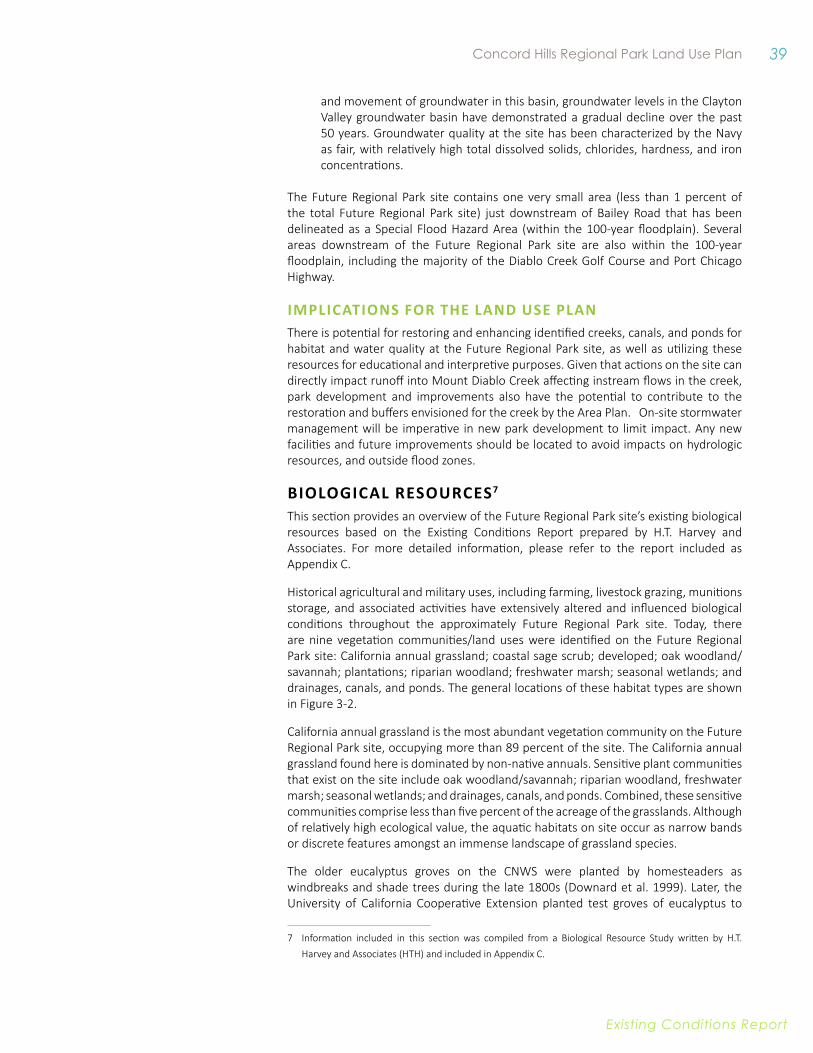
39 Concord Hills Regional Park Land Use Plan
Existing conditions report
and movement of groundwater in this basin, groundwater levels in the Clayton Valley groundwater basin have demonstrated a gradual decline over the past 50 years. Groundwater quality at the site has been characterized by the Navy as fair, with relatively high total dissolved solids, chlorides, hardness, and iron concentrations.
The Future Regional Park site contains one very small area (less than 1 percent of the total Future Regional Park site) just downstream of Bailey Road that has been delineated as a Special Flood Hazard Area (within the 100-year floodplain). Several areas downstream of the Future Regional Park site are also within the 100-year floodplain, including the majority of the Diablo Creek Golf Course and Port Chicago Highway.
iMPliCATiONS fOR THe lAND uSe PlANThere is potential for restoring and enhancing identified creeks, canals, and ponds for habitat and water quality at the Future Regional Park site, as well as utilizing these resources for educational and interpretive purposes. Given that actions on the site can directly impact runoff into Mount Diablo Creek affecting instream flows in the creek, park development and improvements also have the potential to contribute to the restoration and buffers envisioned for the creek by the Area Plan. On-site stormwater management will be imperative in new park development to limit impact. Any new facilities and future improvements should be located to avoid impacts on hydrologic resources, and outside flood zones.
BiOlOGiCAl ReSOuRCeS7 This section provides an overview of the Future Regional Park site’s existing biological resources based on the Existing Conditions Report prepared by H.T. Harvey and Associates. For more detailed information, please refer to the report included as Appendix C.
Historical agricultural and military uses, including farming, livestock grazing, munitions storage, and associated activities have extensively altered and influenced biological conditions throughout the approximately Future Regional Park site. Today, there are nine vegetation communities/land uses were identified on the Future Regional Park site: California annual grassland; coastal sage scrub; developed; oak woodland/savannah; plantations; riparian woodland; freshwater marsh; seasonal wetlands; and drainages, canals, and ponds. The general locations of these habitat types are shown in Figure 3-2.
California annual grassland is the most abundant vegetation community on the Future Regional Park site, occupying more than 89 percent of the site. The California annual grassland found here is dominated by non-native annuals. Sensitive plant communities that exist on the site include oak woodland/savannah; riparian woodland, freshwater marsh; seasonal wetlands; and drainages, canals, and ponds. Combined, these sensitive communities comprise less than five percent of the acreage of the grasslands. Although of relatively high ecological value, the aquatic habitats on site occur as narrow bands or discrete features amongst an immense landscape of grassland species.
The older eucalyptus groves on the CNWS were planted by homesteaders as windbreaks and shade trees during the late 1800s (Downard et al. 1999). Later, the University of California Cooperative Extension planted test groves of eucalyptus to
7 Information included in this section was compiled from a Biological Resource Study written by H.T. Harvey and Associates (HTH) and included in Appendix C.
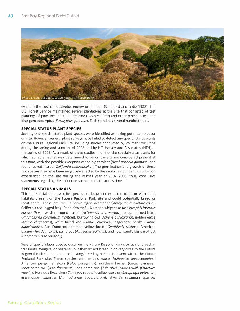
40 East Bay Regional Parks District
Existing conditions report
evaluate the cost of eucalyptus energy production (Sandiford and Ledig 1983). The U.S. Forest Service maintained several plantations at the site that consisted of test plantings of pine, including Coulter pine (Pinus coulteri) and other pine species, and blue gum eucalyptus (Eucalyptus globulus). Each stand has several hundred trees.
SPeCiAl STATuS PlANT SPeCieSSeventy-one special status plant species were identified as having potential to occur on site. However, general plant surveys have failed to detect any special-status plants on the Future Regional Park site, including studies conducted by Vollmar Consulting during the spring and summer of 2008 and by H.T. Harvey and Associates (HTH) in the spring of 2009. As a result of these studies, none of the special-status plants for which suitable habitat was determined to be on the site are considered present at this time, with the possible exception of the big tarplant (Blepharizonia plumose) and round-leaved filaree (California macrophylla). The germination and growth of these two species may have been negatively affected by the rainfall amount and distribution experienced on the site during the rainfall year of 2007–2008; thus, conclusive statements regarding their absence cannot be made at this time.
SPeCiAl STATuS ANiMAlSThirteen special-status wildlife species are known or expected to occur within the habitats present on the Future Regional Park site and could potentially breed or roost there. These are the California tiger salamander(Ambystoma californiense), California red-legged frog (Rana draytonii), Alameda whipsnake (Masticophis lateralis euryxanthus), western pond turtle (Actinemys marmorata), coast horned-lizard (Phrynosoma coronatum frontale), burrowing owl (Athene cunicularia), golden eagle (Aquila chrysaetos), white-tailed kite (Elanus leucurus), loggerhead shrike (Lanius ludovicianus), San Francisco common yellowthroat (Geothlypis trichas), American badger (Taxidea taxus), pallid bat (Antrozous pallidus), and Townsend’s big-eared bat (Corynorhinus townsendii).
Several special status species occur on the Future Regional Park site as nonbreeding transients, foragers, or migrants, but they do not breed in or very close to the Future Regional Park site and suitable nesting/breeding habitat is absent within the Future Regional Park site. These species are the bald eagle (Haliaeetus leucocephalus), American peregrine falcon (Falco peregrinus), northern harrier (Circus cyaneus), short-eared owl (Asio flammeus), long-eared owl (Asio otus), Vaux’s swift (Chaetura vauxi), olive-sided flycatcher (Contopus cooperi), yellow warbler (Setophaga petechia), grasshopper sparrow (Ammodramus savannarum), Bryant’s savannah sparrow
photo credit: Stephen Joseph Fine Art Photography
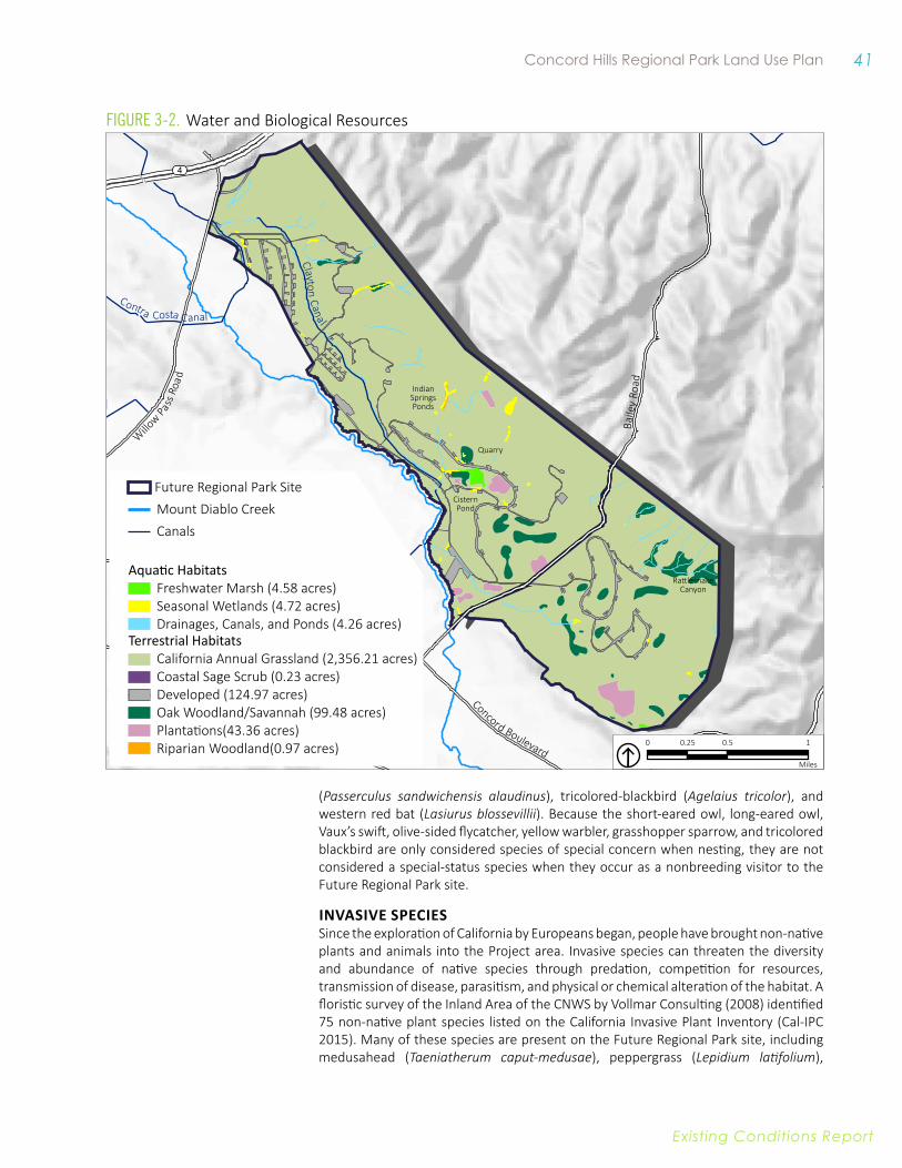
41 Concord Hills Regional Park Land Use Plan
Existing conditions report
(Passerculus sandwichensis alaudinus), tricolored-blackbird (Agelaius tricolor), and western red bat (Lasiurus blossevillii). Because the short-eared owl, long-eared owl, Vaux’s swift, olive-sided flycatcher, yellow warbler, grasshopper sparrow, and tricolored blackbird are only considered species of special concern when nesting, they are not considered a special-status species when they occur as a nonbreeding visitor to the Future Regional Park site.
invaSive SPeCieSSince the exploration of California by Europeans began, people have brought non-native plants and animals into the Project area. Invasive species can threaten the diversity and abundance of native species through predation, competition for resources, transmission of disease, parasitism, and physical or chemical alteration of the habitat. A floristic survey of the Inland Area of the CNWS by Vollmar Consulting (2008) identified 75 non-native plant species listed on the California Invasive Plant Inventory (Cal-IPC 2015). Many of these species are present on the Future Regional Park site, including medusahead (Taeniatherum caput-medusae), peppergrass (Lepidium latifolium),
Concord Boulevard
Clayton Road
Baile
y Ro
ad
Willo
w Pass R
oad
4
Clayto n Cana l
Contra Costa C anal
Indian Springs Ponds
Quarry
Cistern Pond
Rattlesnake Canyon
Mount Diablo CreekCanals
Future Regional Park Site
Aquatic HabitatsFreshwater Marsh (4.58 acres)Seasonal Wetlands (4.72 acres)Drainages, Canals, and Ponds (4.26 acres)
Terrestrial HabitatsCalifornia Annual Grassland (2,356.21 acres)Coastal Sage Scrub (0.23 acres)Developed (124.97 acres)Oak Woodland/Savannah (99.48 acres)
Riparian Woodland(0.97 acres)Plantations(43.36 acres)
0 0.5 10.25
Miles
Figure 3-2. Water and Biological Resources
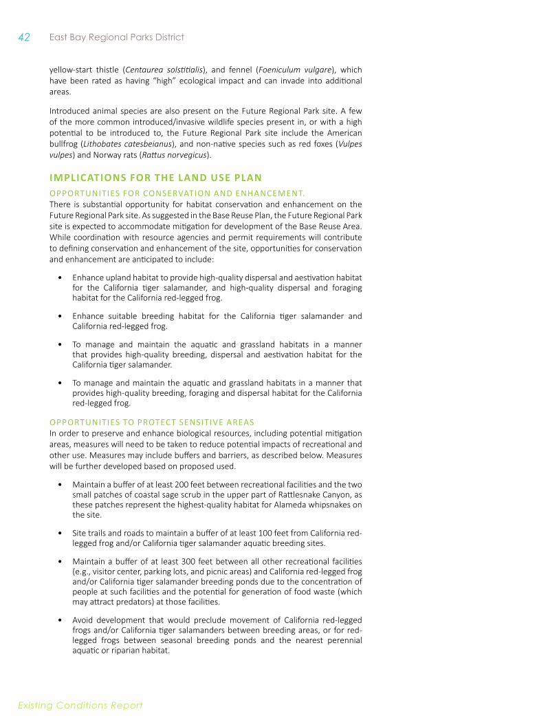
42 East Bay Regional Parks District
Existing conditions report
yellow-start thistle (Centaurea solstitialis), and fennel (Foeniculum vulgare), which have been rated as having “high” ecological impact and can invade into additional areas.
Introduced animal species are also present on the Future Regional Park site. A few of the more common introduced/invasive wildlife species present in, or with a high potential to be introduced to, the Future Regional Park site include the American bullfrog (Lithobates catesbeianus), and non-native species such as red foxes (Vulpes vulpes) and Norway rats (Rattus norvegicus).
iMPliCATiONS fOR THe lAND uSe PlANOppOrTunITIes fOr COnservATIOn AnD enhAnCemenT. There is substantial opportunity for habitat conservation and enhancement on the Future Regional Park site. As suggested in the Base Reuse Plan, the Future Regional Park site is expected to accommodate mitigation for development of the Base Reuse Area. While coordination with resource agencies and permit requirements will contribute to defining conservation and enhancement of the site, opportunities for conservation and enhancement are anticipated to include:
• Enhance upland habitat to provide high-quality dispersal and aestivation habitat for the California tiger salamander, and high-quality dispersal and foraging habitat for the California red-legged frog.
• Enhance suitable breeding habitat for the California tiger salamander and California red-legged frog.
• To manage and maintain the aquatic and grassland habitats in a manner that provides high-quality breeding, dispersal and aestivation habitat for the California tiger salamander.
• To manage and maintain the aquatic and grassland habitats in a manner that provides high-quality breeding, foraging and dispersal habitat for the California red-legged frog.
OppOrtunities tO prOtect sensitive AreAs In order to preserve and enhance biological resources, including potential mitigation areas, measures will need to be taken to reduce potential impacts of recreational and other use. Measures may include buffers and barriers, as described below. Measures will be further developed based on proposed used.
• Maintain a buffer of at least 200 feet between recreational facilities and the two small patches of coastal sage scrub in the upper part of Rattlesnake Canyon, as these patches represent the highest-quality habitat for Alameda whipsnakes on the site.
• Site trails and roads to maintain a buffer of at least 100 feet from California red-legged frog and/or California tiger salamander aquatic breeding sites.
• Maintain a buffer of at least 300 feet between all other recreational facilities (e.g., visitor center, parking lots, and picnic areas) and California red-legged frog and/or California tiger salamander breeding ponds due to the concentration of people at such facilities and the potential for generation of food waste (which may attract predators) at those facilities.
• Avoid development that would preclude movement of California red-legged frogs and/or California tiger salamanders between breeding areas, or for red-legged frogs between seasonal breeding ponds and the nearest perennial aquatic or riparian habitat.
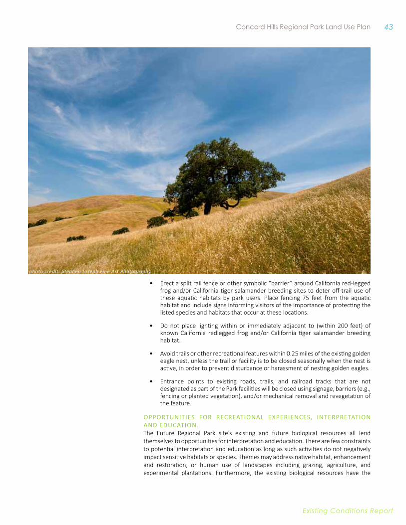
43 Concord Hills Regional Park Land Use Plan
Existing conditions report
• Erect a split rail fence or other symbolic “barrier” around California red-legged frog and/or California tiger salamander breeding sites to deter off-trail use of these aquatic habitats by park users. Place fencing 75 feet from the aquatic habitat and include signs informing visitors of the importance of protecting the listed species and habitats that occur at these locations.
• Do not place lighting within or immediately adjacent to (within 200 feet) of known California redlegged frog and/or California tiger salamander breeding habitat.
• Avoid trails or other recreational features within 0.25 miles of the existing golden eagle nest, unless the trail or facility is to be closed seasonally when the nest is active, in order to prevent disturbance or harassment of nesting golden eagles.
• Entrance points to existing roads, trails, and railroad tracks that are not designated as part of the Park facilities will be closed using signage, barriers (e.g., fencing or planted vegetation), and/or mechanical removal and revegetation of the feature.
OppOrtunities fOr recreAtiOnAl experiences, interpretAtiOn AnD eDuCATIOn. The Future Regional Park site’s existing and future biological resources all lend themselves to opportunities for interpretation and education. There are few constraints to potential interpretation and education as long as such activities do not negatively impact sensitive habitats or species. Themes may address native habitat, enhancement and restoration, or human use of landscapes including grazing, agriculture, and experimental plantations. Furthermore, the existing biological resources have the
photo credit: Stephen Joseph Fine Art Photography
44 East Bay Regional Parks District
Existing conditions report
potential to provide rich visitor experiences, such as memorable interactions with local fauna, a rare occurrence for many urban or suburban residents.
CulTuRAl ReSOuRCeS8 This section builds upon the discussion of historical context provided in Chapter Two by providing specific information about tangible resources that exist on site. Known cultural resources within the Future Regional Park site include 10 archaeological sites, two isolated finds, and approximately 50 buildings and structures. Of these resources, one built structure (the Contra Costa/Clayton Canal) is listed in the National Register of Historic Places (National Register) and California Register of Historical Resources (California Register), as a contributing element to the Central Valley Project, and five archaeological sites are eligible or considered potentially eligible for listing.
Known cultural resources within the LUP area include 10 archaeological sites, two isolated finds, approximately 35 buildings and structures, and numerous ammunition magazines. Of these resources, one built structure (the Contra Costa/Clayton Canal) is listed in the National Register of Historic Places (National Register) and California Register of Historical Resources (California Register) as a contributing element to the Central Valley Project, and one archaeological site (a prehistoric bedrock milling site) has been recommended eligible for listing.
The remaining historic-era archaeological sites, prehistoric isolated finds, and built environment resources (including magazines; main and auxiliary buildings; bridges; railroads; water storage facilities; tunnels; and a small mine) are not included in or meet the eligibility criteria for listing in the National or California Registers.
Archeological resources previously considered as potentially eligible archaeological resources (a 2014 evaluation determined that they were not eligible) included the remains of a historic-era residence with outbuildings; a series of historic-era concrete foundations and artifacts possibly associated with dairy farming; a historic-era foundation and artifact scatter; and an historic-era stone cistern with an associated artifact scatter and windmill. There is a remnant orchard associated with historic-era concrete foundations in the Southern area. While not considered a historic resource, the orchard is of cultural interest and could be incorporated into or inform park development.
iMPliCATiONS fOR THe lAND uSe PlANOppOrtunities fOr resOurce prOtectiOnHistoric Structures. As none of the buildings or structures in the Future Regional Park site are eligible for listing in either the National or California Registers, protection of these resources is not required to avoid impacts under the California Environmental Quality Act. However, there are substantial opportunities for reuse and interpretation of the resources as discussed below.
The Contra Costa Canal. The Contra Costa Canal, and its extension, the Clayton Canal have been previously recommended eligible for listing in the National and California Registers as contributors to the Central Valley Project. Since these resources are owned separately by the Bureau of Reclamation, development of the Regional Park would need to avoid any alterations to the canal without approval from the Bureau of Reclamation.
8 Information included in this section was compiled from a Cultural Resources Study written by Environmental Science Associates (ESA). The Cultural Resource study is included in Appendix D.
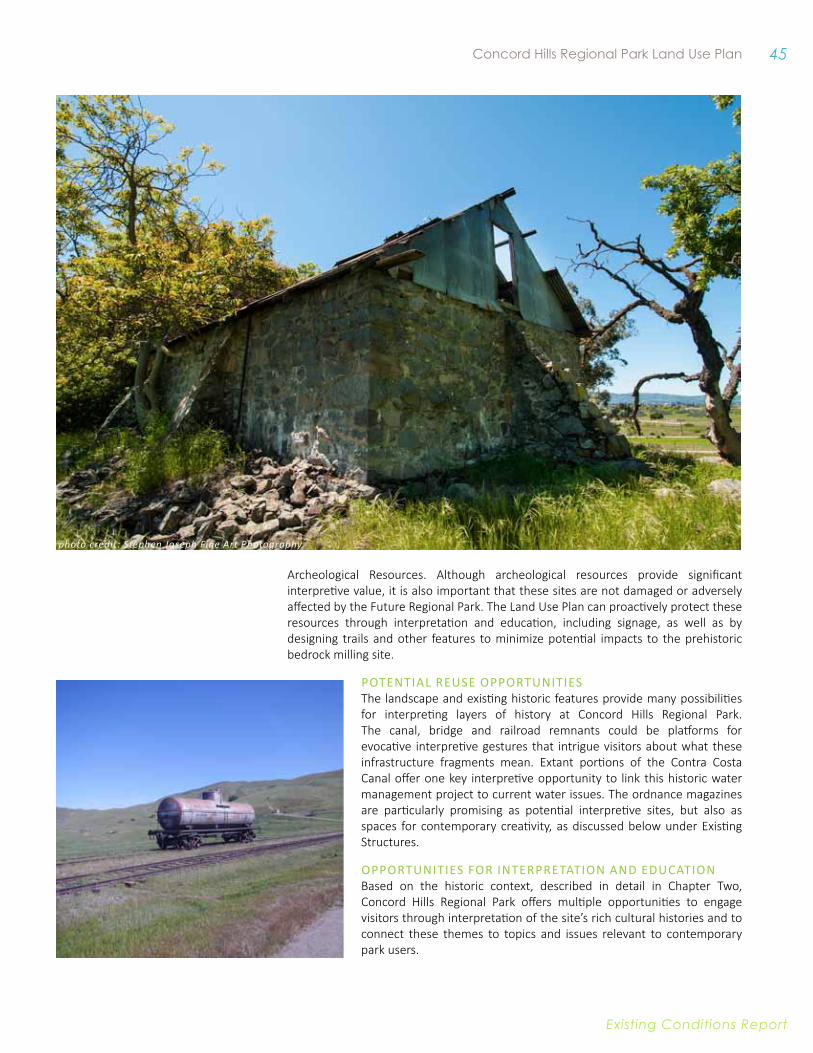
45 Concord Hills Regional Park Land Use Plan
Existing conditions report
Archeological Resources. Although archeological resources provide significant interpretive value, it is also important that these sites are not damaged or adversely affected by the Future Regional Park. The Land Use Plan can proactively protect these resources through interpretation and education, including signage, as well as by designing trails and other features to minimize potential impacts to the prehistoric bedrock milling site.
pOtentiAl reuse OppOrtunities The landscape and existing historic features provide many possibilities for interpreting layers of history at Concord Hills Regional Park. The canal, bridge and railroad remnants could be platforms for evocative interpretive gestures that intrigue visitors about what these infrastructure fragments mean. Extant portions of the Contra Costa Canal offer one key interpretive opportunity to link this historic water management project to current water issues. The ordnance magazines are particularly promising as potential interpretive sites, but also as spaces for contemporary creativity, as discussed below under Existing Structures.
OppOrTunITIes fOr InTerpreTATIOn AnD eDuCATIOn Based on the historic context, described in detail in Chapter Two, Concord Hills Regional Park offers multiple opportunities to engage visitors through interpretation of the site’s rich cultural histories and to connect these themes to topics and issues relevant to contemporary park users.
photo credit: Stephen Joseph Fine Art Photography
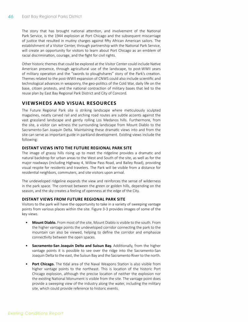
46 East Bay Regional Parks District
Existing conditions report
The story that has brought national attention, and involvement of the National Park Service, is the 1944 explosion at Port Chicago and the subsequent miscarriage of justice that resulted in mutiny charges against fifty African American sailors. The establishment of a Visitor Center, through partnership with the National Park Service, will create an opportunity for visitors to learn about Port Chicago as an emblem of racial discrimination, courage, and the fight for civil rights.
Other historic themes that could be explored at the Visitor Center could include Native American presence, through agricultural use of the landscape, to post-WWII years of military operation and the “swords to ploughshares” story of the Park’s creation. Themes related to the post-WWII expansion of CNWS could also include scientific and technological advances in weaponry, the geo-politics of the Cold War, daily life on the base, citizen protests, and the national contraction of military bases that led to the reuse plan by East Bay Regional Park District and City of Concord.
vieWSHeDS AND viSuAl ReSOuRCeSThe Future Regional Park site is striking landscape where meticulously sculpted magazines, neatly carved rail and arching road routes are subtle accents against the vast grassland landscape and gently rolling Los Medanos hills. Furthermore, from the site, a visitor can witness the surrounding landscape from Mount Diablo to the Sacramento-San Joaquin Delta. Maintaining these dramatic views into and from the site can serve as important guide in parkland development. Existing views include the following:
DiSTANT vieWS iNTO THe fuTuRe ReGiONAl PARk SiTe The image of grassy hills rising up to meet the ridgeline provides a dramatic and natural backdrop for urban areas to the West and South of the site, as well as for the major roadways (including Highway 4, Willow Pass Road, and Bailey Road), providing visual respite for residents and travelers. The Park will be visible from a distance for residential neighbors, commuters, and site visitors upon arrival.
The undeveloped ridgeline expands the view and reinforces the sense of wilderness in the park space. The contrast between the green or golden hills, depending on the season, and the sky creates a feeling of openness at the edge of the City.
DiSTANT vieWS fROM fuTuRe ReGiONAl PARk SiTe Visitors to the park will have the opportunity to take in a variety of sweeping vantage points from various places within the site. Figure 3-3 provides images of some of the key views.
• Mount Diablo. From most of the site, Mount Diablo is visible to the south. From the higher vantage points the undeveloped corridor connecting the park to the mountain can also be viewed, helping to define the corridor and emphasize connectivity between the open spaces.
• Sacramento-San Joaquin Delta and Suisun Bay. Additionally, from the higher vantage points it is possible to see over the ridge into the Sacramento-San Joaquin Delta to the east, the Suisun Bay and the Sacramento River to the north.
• Port Chicago. The tidal area of the Naval Weapons Station is also visible from higher vantage points to the northeast. This is location of the historic Port Chicago explosion, although the precise location of neither the explosion nor the existing National Monument is visible from the site. The vantage point does provide a sweeping view of the industry along the water, including the military site, which could provide reference to historic events.

47 Concord Hills Regional Park Land Use Plan
Existing conditions report
Figure 3-3. Viewpoints
3
21
DiSTANT vieWS fROM fuTuRe ReGiONAl PARk SiTe
Will
ow P
ass R
oad
Concord Boulevard
Clayton Road
Baile
y Ro
ad
Kirk
er Pass R oad
Concord Avenue
%&'(680
4
242
Port
Chi
cago
Hig
hway
0 0.5 10.25
Miles
EDC AreaFuture Regional Park Site East Bay RegionalParks Ridgeline
Other Open Space
3
2
1
4
6
5
photo credit: Stephen Joseph Fine Art Photography
photo credit: Stephen Joseph Fine Art Photography
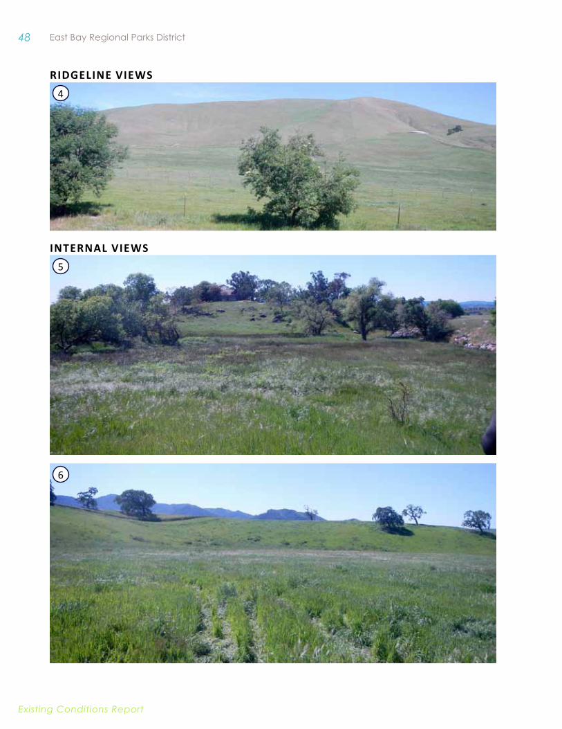
48 East Bay Regional Parks District
Existing conditions report
Ridgeline viewS
inTeRnal viewS
4
5
6
49 Concord Hills Regional Park Land Use Plan
Existing conditions report
• Adjacent Development. Within these larger views, it is also possible to see surrounding urban development from neighboring cities and unincorporated areas. As the Concord Reuse Plan area develops, this condition will be in more immediate view.
iNTeRNAl vieWSHeDS The steep south-facing slopes that characterize the upper portion of the property are largely unscarred by roads, and the remnant facilities that punctuate the landscape have the potential to instill a sense of wonder in the viewer, while the natural elements, such vegetation and geologic patterns along the hills, help provide a picturesque lesson in California ecology, with grasslands and wildflower meadows along the grazed hillsides, historic oaks scattered across the site, and riparian vegetation extending into drainage areas.
As seen in Figure 3-3, the view from the east side of Building IA-24 provides an interesting microcosm of the park space. The flat grassy space behind the building is interrupted by a steep, sculpted hillside. The northern edge of the view contains historic magazines, while the southern edge contains a corral. In a brief look from this view, both the natural and cultural settings of the site become apparent. Views of the magazine clusters and associated sculpted landscape provide another unique perspective on-site.
iMPliCATiONS fOR THe lAND uSe PlANViews are valuable resource of the Future Regional Park site that should be managed and protected. The Future Regional Park will be at the edge of an urban development, but effective management of viewsheds can provide the visitor with a regional park experience and a sense of being away, while also providing a picturesque backdrop for surrounding urban areas and commuters.
Potential viewshed opportunities include:
• Regional Perspective. The views of surrounding region can be important educational opportunities for teaching about landscape features and natural processes, and provide a rich visual experience. This includes sites with views out to the Sacramento-San Joaquin Delta, Port Chicago, and the Bay, as well as views into the site and its landscape elements. Numerous opportunities exist to highlight open space connections to Black Diamond Mines and Mount Diablo by framing views to the south.
• Adjacent Development. While future adjacent development will transform existing long-range views and therefore the experience of being away from urbanization, there are areas throughout the park where visual refuge exist due to topography or could be created through screening or otherwise. In some areas, views of adjacent development may become interpretive opportunities.
• views of the Site. Park development must also consider views of the site from within the site and from surrounding region. The unscarred hillsides are an important resource, as are the existing structures and magazine clusters discussed under Existing Infrastructure below. For instance, mid-slope trails constructed across these slopes would be visible from long distances and would change the visual character of the setting while trails along the flat valley bottom have few off-site visibility impacts.
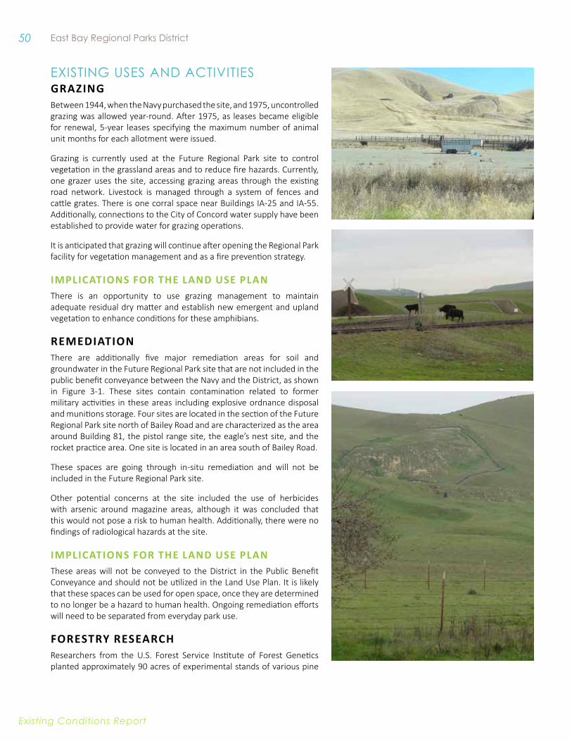
50 East Bay Regional Parks District
Existing conditions report
ExIstIng UsEs anD aCtIvItIEsGRAziNG Between 1944, when the Navy purchased the site, and 1975, uncontrolled grazing was allowed year-round. After 1975, as leases became eligible for renewal, 5-year leases specifying the maximum number of animal unit months for each allotment were issued.
Grazing is currently used at the Future Regional Park site to control vegetation in the grassland areas and to reduce fire hazards. Currently, one grazer uses the site, accessing grazing areas through the existing road network. Livestock is managed through a system of fences and cattle grates. There is one corral space near Buildings IA-25 and IA-55. Additionally, connections to the City of Concord water supply have been established to provide water for grazing operations.
It is anticipated that grazing will continue after opening the Regional Park facility for vegetation management and as a fire prevention strategy.
iMPliCATiONS fOR THe lAND uSe PlANThere is an opportunity to use grazing management to maintain adequate residual dry matter and establish new emergent and upland vegetation to enhance conditions for these amphibians.
ReMeDiATiON There are additionally five major remediation areas for soil and groundwater in the Future Regional Park site that are not included in the public benefit conveyance between the Navy and the District, as shown in Figure 3-1. These sites contain contamination related to former military activities in these areas including explosive ordnance disposal and munitions storage. Four sites are located in the section of the Future Regional Park site north of Bailey Road and are characterized as the area around Building 81, the pistol range site, the eagle’s nest site, and the rocket practice area. One site is located in an area south of Bailey Road.
These spaces are going through in-situ remediation and will not be included in the Future Regional Park site.
Other potential concerns at the site included the use of herbicides with arsenic around magazine areas, although it was concluded that this would not pose a risk to human health. Additionally, there were no findings of radiological hazards at the site.
iMPliCATiONS fOR THe lAND uSe PlANThese areas will not be conveyed to the District in the Public Benefit Conveyance and should not be utilized in the Land Use Plan. It is likely that these spaces can be used for open space, once they are determined to no longer be a hazard to human health. Ongoing remediation efforts will need to be separated from everyday park use.
fOReSTRy ReSeARCHResearchers from the U.S. Forest Service Institute of Forest Genetics planted approximately 90 acres of experimental stands of various pine
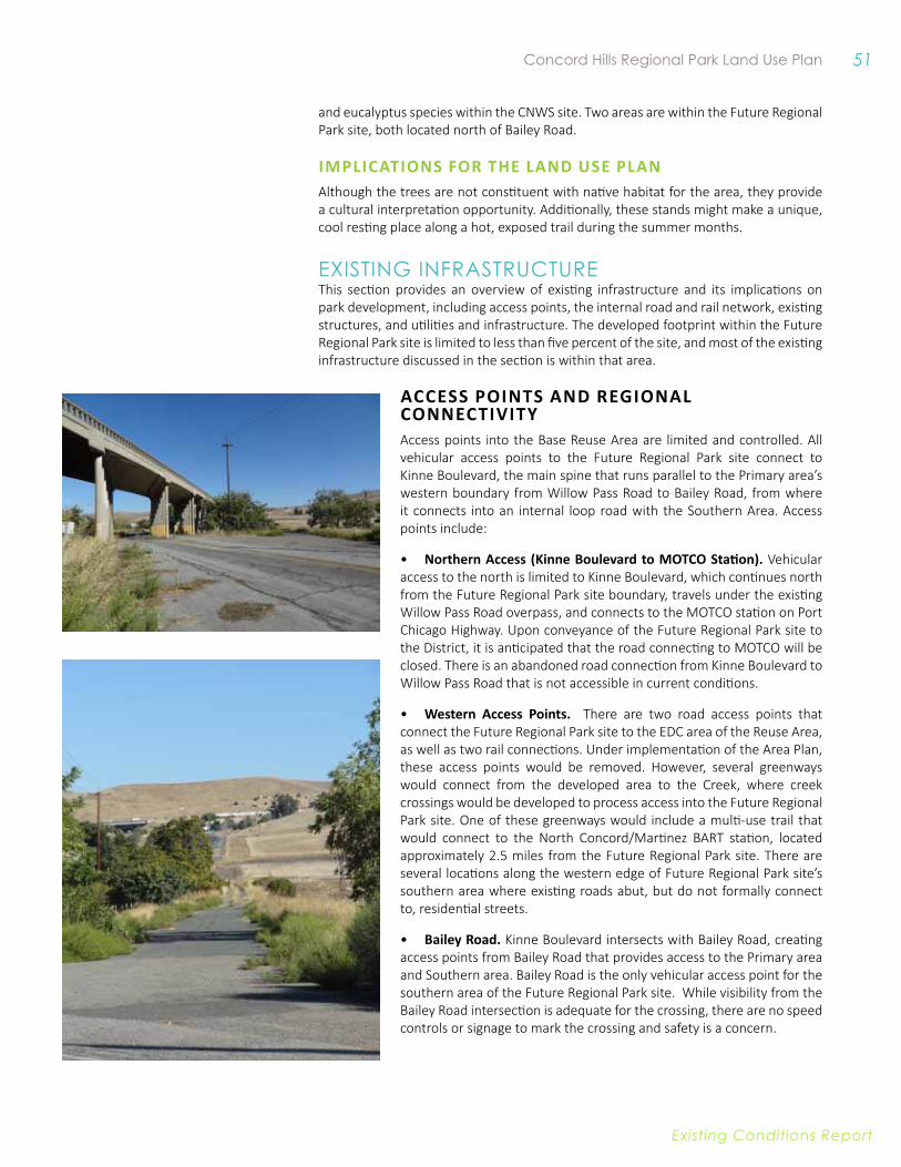
51 Concord Hills Regional Park Land Use Plan
Existing conditions report
and eucalyptus species within the CNWS site. Two areas are within the Future Regional Park site, both located north of Bailey Road.
iMPliCATiONS fOR THe lAND uSe PlANAlthough the trees are not constituent with native habitat for the area, they provide a cultural interpretation opportunity. Additionally, these stands might make a unique, cool resting place along a hot, exposed trail during the summer months.
ExIstIng InfRastRUCtURE This section provides an overview of existing infrastructure and its implications on park development, including access points, the internal road and rail network, existing structures, and utilities and infrastructure. The developed footprint within the Future Regional Park site is limited to less than five percent of the site, and most of the existing infrastructure discussed in the section is within that area.
aCCeSS PoinTS and Regional ConneCTiviTyAccess points into the Base Reuse Area are limited and controlled. All vehicular access points to the Future Regional Park site connect to Kinne Boulevard, the main spine that runs parallel to the Primary area’s western boundary from Willow Pass Road to Bailey Road, from where it connects into an internal loop road with the Southern Area. Access points include:
• Northern Access (kinne Boulevard to MOTCO Station). Vehicular access to the north is limited to Kinne Boulevard, which continues north from the Future Regional Park site boundary, travels under the existing Willow Pass Road overpass, and connects to the MOTCO station on Port Chicago Highway. Upon conveyance of the Future Regional Park site to the District, it is anticipated that the road connecting to MOTCO will be closed. There is an abandoned road connection from Kinne Boulevard to Willow Pass Road that is not accessible in current conditions.
• western access Points. There are two road access points that connect the Future Regional Park site to the EDC area of the Reuse Area, as well as two rail connections. Under implementation of the Area Plan, these access points would be removed. However, several greenways would connect from the developed area to the Creek, where creek crossings would be developed to process access into the Future Regional Park site. One of these greenways would include a multi-use trail that would connect to the North Concord/Martinez BART station, located approximately 2.5 miles from the Future Regional Park site. There are several locations along the western edge of Future Regional Park site’s southern area where existing roads abut, but do not formally connect to, residential streets.
• Bailey Road. Kinne Boulevard intersects with Bailey Road, creating access points from Bailey Road that provides access to the Primary area and Southern area. Bailey Road is the only vehicular access point for the southern area of the Future Regional Park site. While visibility from the Bailey Road intersection is adequate for the crossing, there are no speed controls or signage to mark the crossing and safety is a concern.
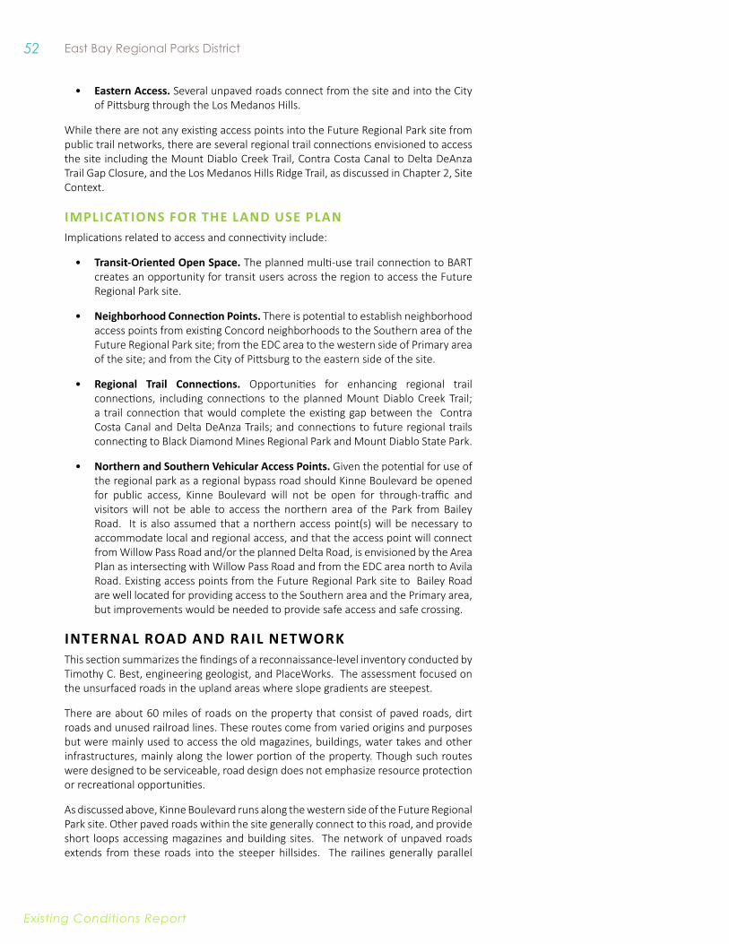
52 East Bay Regional Parks District
Existing conditions report
• eastern access. Several unpaved roads connect from the site and into the City of Pittsburg through the Los Medanos Hills.
While there are not any existing access points into the Future Regional Park site from public trail networks, there are several regional trail connections envisioned to access the site including the Mount Diablo Creek Trail, Contra Costa Canal to Delta DeAnza Trail Gap Closure, and the Los Medanos Hills Ridge Trail, as discussed in Chapter 2, Site Context.
iMPliCATiONS fOR THe lAND uSe PlANImplications related to access and connectivity include:
• Transit-Oriented Open Space. The planned multi-use trail connection to BART creates an opportunity for transit users across the region to access the Future Regional Park site.
• Neighborhood Connection Points. There is potential to establish neighborhood access points from existing Concord neighborhoods to the Southern area of the Future Regional Park site; from the EDC area to the western side of Primary area of the site; and from the City of Pittsburg to the eastern side of the site.
• Regional Trail Connections. Opportunities for enhancing regional trail connections, including connections to the planned Mount Diablo Creek Trail; a trail connection that would complete the existing gap between the Contra Costa Canal and Delta DeAnza Trails; and connections to future regional trails connecting to Black Diamond Mines Regional Park and Mount Diablo State Park.
• Northern and Southern vehicular Access Points. Given the potential for use of the regional park as a regional bypass road should Kinne Boulevard be opened for public access, Kinne Boulevard will not be open for through-traffic and visitors will not be able to access the northern area of the Park from Bailey Road. It is also assumed that a northern access point(s) will be necessary to accommodate local and regional access, and that the access point will connect from Willow Pass Road and/or the planned Delta Road, is envisioned by the Area Plan as intersecting with Willow Pass Road and from the EDC area north to Avila Road. Existing access points from the Future Regional Park site to Bailey Road are well located for providing access to the Southern area and the Primary area, but improvements would be needed to provide safe access and safe crossing.
inTeRnal Road and Rail neTwoRkThis section summarizes the findings of a reconnaissance-level inventory conducted by Timothy C. Best, engineering geologist, and PlaceWorks. The assessment focused on the unsurfaced roads in the upland areas where slope gradients are steepest.
There are about 60 miles of roads on the property that consist of paved roads, dirt roads and unused railroad lines. These routes come from varied origins and purposes but were mainly used to access the old magazines, buildings, water takes and other infrastructures, mainly along the lower portion of the property. Though such routes were designed to be serviceable, road design does not emphasize resource protection or recreational opportunities.
As discussed above, Kinne Boulevard runs along the western side of the Future Regional Park site. Other paved roads within the site generally connect to this road, and provide short loops accessing magazines and building sites. The network of unpaved roads extends from these roads into the steeper hillsides. The railines generally parallel
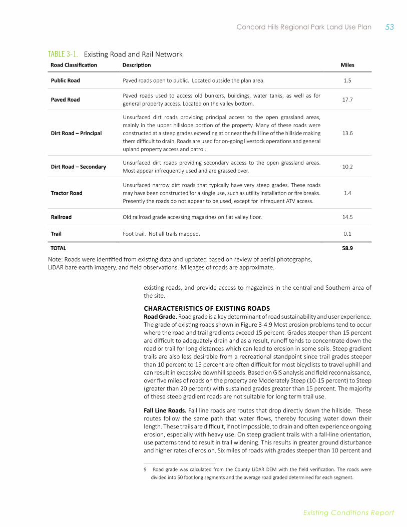
53 Concord Hills Regional Park Land Use Plan
Existing conditions report
Road Classification Description Miles
Public Road Paved roads open to public. Located outside the plan area. 1.5
Paved RoadPaved roads used to access old bunkers, buildings, water tanks, as well as for general property access. Located on the valley bottom.
17.7
Dirt Road – Principal
Unsurfaced dirt roads providing principal access to the open grassland areas, mainly in the upper hillslope portion of the property. Many of these roads were constructed at a steep grades extending at or near the fall line of the hillside making them difficult to drain. Roads are used for on-going livestock operations and general upland property access and patrol.
13.6
Dirt Road – SecondaryUnsurfaced dirt roads providing secondary access to the open grassland areas. Most appear infrequently used and are grassed over.
10.2
Tractor RoadUnsurfaced narrow dirt roads that typically have very steep grades. These roads may have been constructed for a single use, such as utility installation or fire breaks. Presently the roads do not appear to be used, except for infrequent ATV access.
1.4
Railroad Old railroad grade accessing magazines on flat valley floor. 14.5
Trail Foot trail. Not all trails mapped. 0.1
ToTal 58.9
Note: Roads were identified from existing data and updated based on review of aerial photographs, LiDAR bare earth imagery, and field observations. Mileages of roads are approximate.
Table 3-1. Existing Road and Rail Network
CHARACTeRiSTiCS Of exiSTiNG ROADSRoad Grade. Road grade is a key determinant of road sustainability and user experience. The grade of existing roads shown in Figure 3-4.9 Most erosion problems tend to occur where the road and trail gradients exceed 15 percent. Grades steeper than 15 percent are difficult to adequately drain and as a result, runoff tends to concentrate down the road or trail for long distances which can lead to erosion in some soils. Steep gradient trails are also less desirable from a recreational standpoint since trail grades steeper than 10 percent to 15 percent are often difficult for most bicyclists to travel uphill and can result in excessive downhill speeds. Based on GIS analysis and field reconnaissance, over five miles of roads on the property are Moderately Steep (10-15 percent) to Steep (greater than 20 percent) with sustained grades greater than 15 percent. The majority of these steep gradient roads are not suitable for long term trail use.
fall line Roads. Fall line roads are routes that drop directly down the hillside. These routes follow the same path that water flows, thereby focusing water down their length. These trails are difficult, if not impossible, to drain and often experience ongoing erosion, especially with heavy use. On steep gradient trails with a fall-line orientation, use patterns tend to result in trail widening. This results in greater ground disturbance and higher rates of erosion. Six miles of roads with grades steeper than 10 percent and
9 Road grade was calculated from the County LiDAR DEM with the field verification. The roads were divided into 50 foot long segments and the average road graded determined for each segment.
existing roads, and provide access to magazines in the central and Southern area of the site.
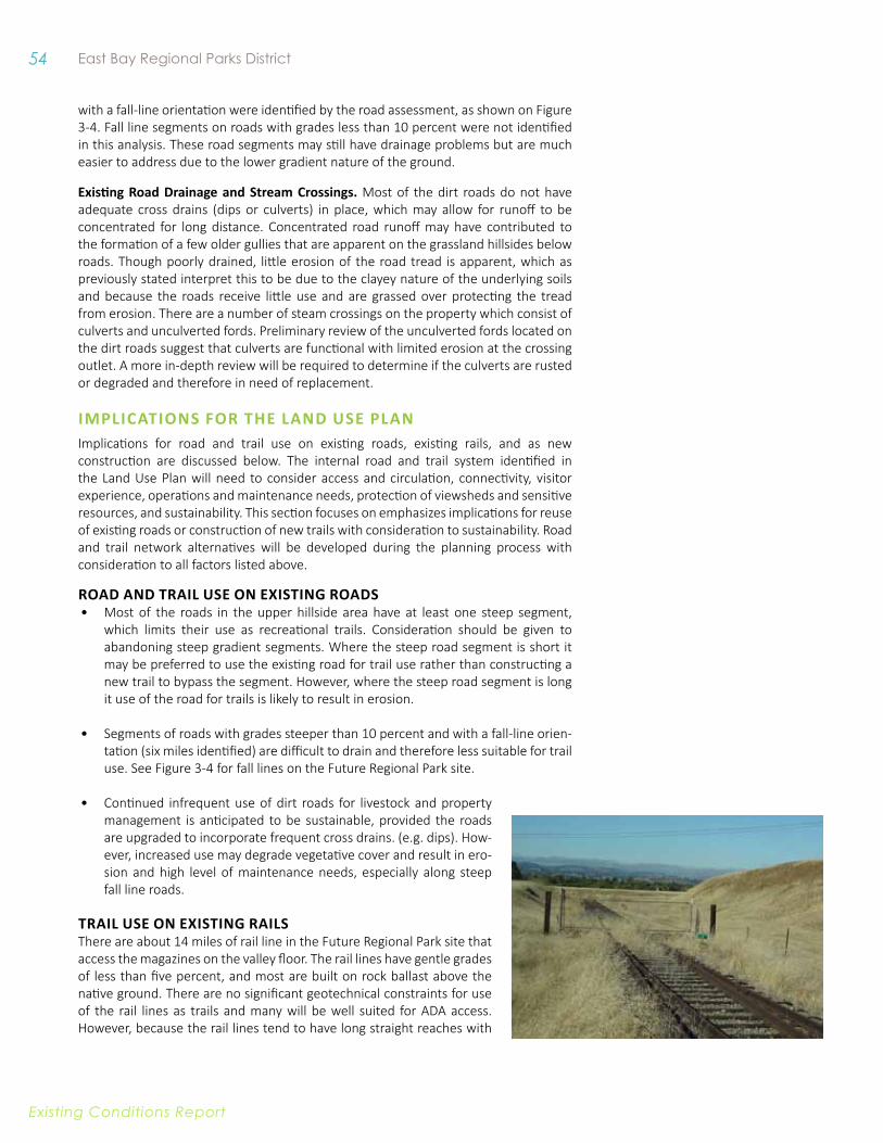
54 East Bay Regional Parks District
Existing conditions report
with a fall-line orientation were identified by the road assessment, as shown on Figure 3-4. Fall line segments on roads with grades less than 10 percent were not identified in this analysis. These road segments may still have drainage problems but are much easier to address due to the lower gradient nature of the ground.
existing Road Drainage and Stream Crossings. Most of the dirt roads do not have adequate cross drains (dips or culverts) in place, which may allow for runoff to be concentrated for long distance. Concentrated road runoff may have contributed to the formation of a few older gullies that are apparent on the grassland hillsides below roads. Though poorly drained, little erosion of the road tread is apparent, which as previously stated interpret this to be due to the clayey nature of the underlying soils and because the roads receive little use and are grassed over protecting the tread from erosion. There are a number of steam crossings on the property which consist of culverts and unculverted fords. Preliminary review of the unculverted fords located on the dirt roads suggest that culverts are functional with limited erosion at the crossing outlet. A more in-depth review will be required to determine if the culverts are rusted or degraded and therefore in need of replacement.
iMPliCATiONS fOR THe lAND uSe PlANImplications for road and trail use on existing roads, existing rails, and as new construction are discussed below. The internal road and trail system identified in the Land Use Plan will need to consider access and circulation, connectivity, visitor experience, operations and maintenance needs, protection of viewsheds and sensitive resources, and sustainability. This section focuses on emphasizes implications for reuse of existing roads or construction of new trails with consideration to sustainability. Road and trail network alternatives will be developed during the planning process with consideration to all factors listed above.
ROAD AND TRAil uSe ON exiSTiNG ROADS • Most of the roads in the upper hillside area have at least one steep segment,
which limits their use as recreational trails. Consideration should be given to abandoning steep gradient segments. Where the steep road segment is short it may be preferred to use the existing road for trail use rather than constructing a new trail to bypass the segment. However, where the steep road segment is long it use of the road for trails is likely to result in erosion.
• Segments of roads with grades steeper than 10 percent and with a fall-line orien-tation (six miles identified) are difficult to drain and therefore less suitable for trail use. See Figure 3-4 for fall lines on the Future Regional Park site.
• Continued infrequent use of dirt roads for livestock and property management is anticipated to be sustainable, provided the roads are upgraded to incorporate frequent cross drains. (e.g. dips). How-ever, increased use may degrade vegetative cover and result in ero-sion and high level of maintenance needs, especially along steep fall line roads.
TRAil uSe ON exiSTiNG RAilSThere are about 14 miles of rail line in the Future Regional Park site that access the magazines on the valley floor. The rail lines have gentle grades of less than five percent, and most are built on rock ballast above the native ground. There are no significant geotechnical constraints for use of the rail lines as trails and many will be well suited for ADA access. However, because the rail lines tend to have long straight reaches with
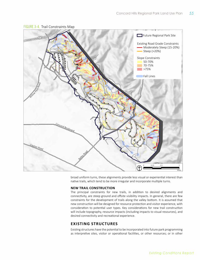
55 Concord Hills Regional Park Land Use Plan
Existing conditions report
Concord Boulevard
Clayton Road
Bailey R
oad
Willo
w Pass R
oad
4
0 0.5 10.25
Miles
0 0.5 10.25
Miles
Future Regional Park Site
Moderately Steep (15-20%)Steep (>20%)
Existing Road Grade Constraints
50-70%70-75%
Slope Constraints
>75%
Fall Lines
Figure 3-4. Trail Constraints Map
broad uniform turns, these alignments provide less visual or experiential interest than native trails, which tend to be more irregular and incorporate multiple turns.
NeW TRAil CONSTRuCTiONThe principal constraints for new trails, in addition to desired alignments and connectivity, are steep ground and offsite visibility impacts. In general, there are few constraints for the development of trails along the valley bottom. It is assumed that new construction will be designed for resource protection and visitor experience, with consideration to potential user types. Key considerations for new trail construction will include topography, resource impacts (including impacts to visual resources), and desired connectivity and recreational experience.
exiSTiNG STRuCTuReS Existing structures have the potential to be incorporated into future park programming as interpretive sites, visitor or operational facilities, or other resources; or in other
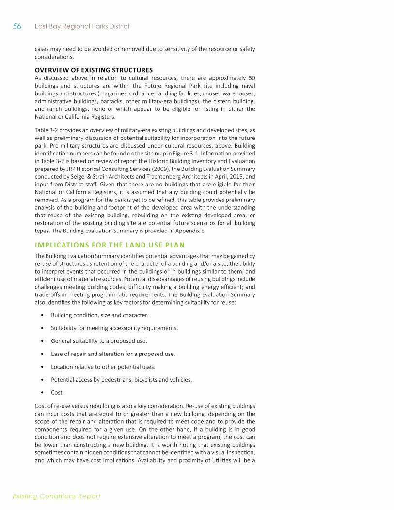
56 East Bay Regional Parks District
Existing conditions report
cases may need to be avoided or removed due to sensitivity of the resource or safety considerations.
OveRvieW Of exiSTiNG STRuCTuReSAs discussed above in relation to cultural resources, there are approximately 50 buildings and structures are within the Future Regional Park site including naval buildings and structures (magazines, ordnance handling facilities, unused warehouses, administrative buildings, barracks, other military-era buildings), the cistern building, and ranch buildings, none of which appear to be eligible for listing in either the National or California Registers.
Table 3-2 provides an overview of military-era existing buildings and developed sites, as well as preliminary discussion of potential suitability for incorporation into the future park. Pre-military structures are discussed under cultural resources, above. Building identification numbers can be found on the site map in Figure 3-1. Information provided in Table 3-2 is based on review of report the Historic Building Inventory and Evaluation prepared by JRP Historical Consulting Services (2009), the Building Evaluation Summary conducted by Seigel & Strain Architects and Trachtenberg Architects in April, 2015, and input from District staff. Given that there are no buildings that are eligible for their National or California Registers, it is assumed that any building could potentially be removed. As a program for the park is yet to be refined, this table provides preliminary analysis of the building and footprint of the developed area with the understanding that reuse of the existing building, rebuilding on the existing developed area, or restoration of the existing building site are potential future scenarios for all building types. The Building Evaluation Summary is provided in Appendix E.
iMPliCATiONS fOR THe lAND uSe PlANThe Building Evaluation Summary identifies potential advantages that may be gained by re-use of structures as retention of the character of a building and/or a site; the ability to interpret events that occurred in the buildings or in buildings similar to them; and efficient use of material resources. Potential disadvantages of reusing buildings include challenges meeting building codes; difficulty making a building energy efficient; and trade-offs in meeting programmatic requirements. The Building Evaluation Summary also identifies the following as key factors for determining suitability for reuse:
• Building condition, size and character.
• Suitability for meeting accessibility requirements.
• General suitability to a proposed use.
• Ease of repair and alteration for a proposed use.
• Location relative to other potential uses.
• Potential access by pedestrians, bicyclists and vehicles.
• Cost.
Cost of re-use versus rebuilding is also a key consideration. Re-use of existing buildings can incur costs that are equal to or greater than a new building, depending on the scope of the repair and alteration that is required to meet code and to provide the components required for a given use. On the other hand, if a building is in good condition and does not require extensive alteration to meet a program, the cost can be lower than constructing a new building. It is worth noting that existing buildings sometimes contain hidden conditions that cannot be identified with a visual inspection, and which may have cost implications. Availability and proximity of utilities will be a

57 Concord Hills Regional Park Land Use Plan
Existing conditions report
Table 3-2. Existing Buildings and Developed Sites
Developed Site BuildingsConsiderations for incorporation in Future Park programming
Central Complex
Developed site: ~7 acres
Building IA-24: 11,0000 sf
Building IA-55: 3,500 sf
• Includes IA-24, IA-55, and associated utility sheds
• Centrally located along Kinne Boulevard
• Located in proximity to Diablo Creek and future development
• Grand view of Los Medanos Hills
• Building IA-24
• Former shop and warehouse building
• Generous open room with daylit, open, lofty space and well framed hill views
• Contains industrial features that could be interpreted
• Character lends itself to adaptation for variety of uses.
• Building IA-55: One-story former-office building; Could support office or storage uses; character not well-suited for visitor uses
Building 97 Complex
Developed site: ~2.5 acres
Building 97: 15,442 sf • Includes Buildings 97, 98, and 151
• Former Warhead Assembly and Testing area
• Contains three non-descript industrial buildings and utility structures; few character-defining features
• Located on benched hillside area; provides good view of Future Regional Park site
• Accessed by a steep road; directly east of the Southeastern Complex.
• Buildings have potential for use as warehouse, maintenance yard or similar; would require significant alterations to be suitable for visitor use

58 East Bay Regional Parks District
Existing conditions report
Developed Site BuildingsConsiderations for incorporation in Future Park programming
Building 87 Complex
Developed site:: ~1.75 Acres
Building 87: 21,883 sf • Includes Building 87 and associated utility buildings.
• Sits on a benched hillside area accessed by a steep road; not in proximity to park access points.
• Offers panoramic views that take in Mt Diablo to the southwest, urban areas to the west, and Suisun Bay, with Port Chicago, to the north.
• Buildings have very few character defining features.
• Buildings have potential for use as warehouse, maintenance yard or similar; would require significant alterations to be suitable for visitor use.
Building 81 Complex
Developed site:: ~ 2.5 Acres
Building 81: 24,677 sf
Other buildings combined: 8,697 sf
• Includes Buildings 81, 83, 84, 86 and two accessory buildings.
• Offers views typical of hillside locations.
• Located within area under remediation and therefore not currently anticipated to be suitable for public use.
Southeastern Complex
Developed site: ~10 Acres
Building 420: 5,246 sf
Building 93: 36,465 sf
Building 94: 3,218 sf
• Includes Buildings 93, 94, 420, and small accessory buildings
• Accessible from Kinne Boulevard, approximately 0.25 miles north of Bailey Road
• Few character-defining features
Magazine Complex (18 magazines in proximity to IA-24)
enclosed Area: 520 sf (typ)
footprint: 575 sf (typ)
• Former munitions storage
• Accessible by paved road only
• Complex is in proximity to 1A-24 and main road, on a gentle grade
• Shells in fair to good condition
• Form is sculptural from landscape perspective
• Potential for interpretation or creative re-use
Magazines in Other Areas Typically larger than maga-zine Complex in proximity to IA-24
• Former munitions storage
• Generally accessible by paved road and rail
• Shells in fair to good condition, with greater distance between each magazine
• Potential for interpretation or creative re-use, or removal

59 Concord Hills Regional Park Land Use Plan
Existing conditions report
consideration for facility location, regardless of whether buildings are reused or newly constructed; see further discussion of utilities below.
STRuCTuReS AND DevelOPeD SiTeS WiTH HiGH POTeNTiAl fOR ReuSeThere are several structures and associated sites that have been identified as having high potential for reuse, either of the structure itself or the site. These structures and sites are further discussed below. However, opportunities for reuse are not limited to the areas discussed. Removal of buildings that do not contribute to the park program would not be constrained by historic registries, but other constraints such as perceived value, would need to be considered prior to such decisions.
CeNTRAl COMPlex (BuilDiNG 1A- 24 AND BuilDiNG iA-55)The character of IA-24 lends itself to adaptation to a variety of uses. These uses may include offices, park partner programs, conference or event facilities, and the like. The dramatic daylit space and large view windows, combined with the industrial character of the building, would make for a memorable public venue or visitor center
and the location within the Park would have good connections to roads and trails. The building is large enough to accommodate a special area devoted to Port Chicago exhibits and programming, and areas supporting interpretation of additional themes beginning with Native American presence, through agricultural use of the landscape, to post-WWII years of military operation and the “swords to ploughshares” story of the Park’s creation. The nearby adjacent building IA-55 was also identified as having high potential to serve as offices for District staff or partners.
Cost for reuse is estimated at $6 to 8.5 million dollars, assuming use as a public facility. Cost for rebuilding at the existing site is estimated to range from $4.5 to 6.5 million dollars, assuming that the new building is the same size as the current building. This cost estimate is a preliminary, conceptual estimate intended for planning purposes only.
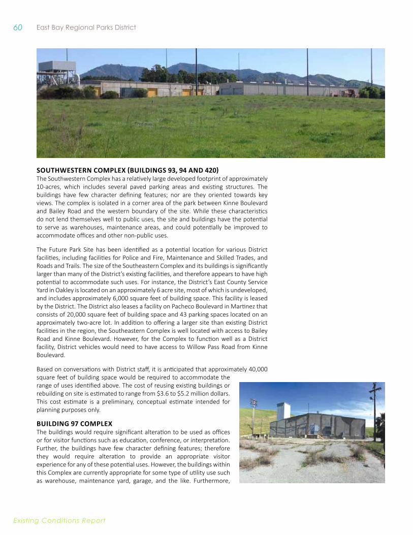
60 East Bay Regional Parks District
Existing conditions report
SOuTHWeSTeRN COMPlex (BuilDiNGS 93, 94 AND 420)The Southwestern Complex has a relatively large developed footprint of approximately 10-acres, which includes several paved parking areas and existing structures. The buildings have few character defining features; nor are they oriented towards key views. The complex is isolated in a corner area of the park between Kinne Boulevard and Bailey Road and the western boundary of the site. While these characteristics do not lend themselves well to public uses, the site and buildings have the potential to serve as warehouses, maintenance areas, and could potentially be improved to accommodate offices and other non-public uses.
The Future Park Site has been identified as a potential location for various District facilities, including facilities for Police and Fire, Maintenance and Skilled Trades, and Roads and Trails. The size of the Southeastern Complex and its buildings is significantly larger than many of the District’s existing facilities, and therefore appears to have high potential to accommodate such uses. For instance, the District’s East County Service Yard in Oakley is located on an approximately 6 acre site, most of which is undeveloped, and includes approximately 6,000 square feet of building space. This facility is leased by the District. The District also leases a facility on Pacheco Boulevard in Martinez that consists of 20,000 square feet of building space and 43 parking spaces located on an approximately two-acre lot. In addition to offering a larger site than existing District facilities in the region, the Southeastern Complex is well located with access to Bailey Road and Kinne Boulevard. However, for the Complex to function well as a District facility, District vehicles would need to have access to Willow Pass Road from Kinne Boulevard.
Based on conversations with District staff, it is anticipated that approximately 40,000 square feet of building space would be required to accommodate the range of uses identified above. The cost of reusing existing buildings or rebuilding on site is estimated to range from $3.6 to $5.2 million dollars. This cost estimate is a preliminary, conceptual estimate intended for planning purposes only.
BuilDiNG 97 COMPlexThe buildings would require significant alteration to be used as offices or for visitor functions such as education, conference, or interpretation. Further, the buildings have few character defining features; therefore they would require alteration to provide an appropriate visitor experience for any of these potential uses. However, the buildings within this Complex are currently appropriate for some type of utility use such as warehouse, maintenance yard, garage, and the like. Furthermore,
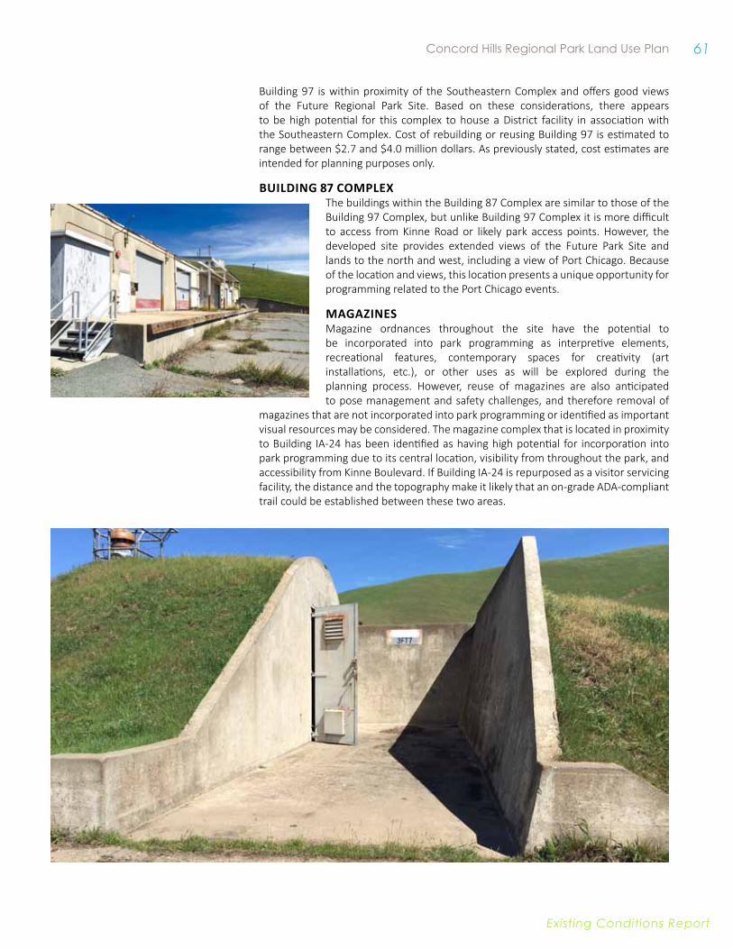
61 Concord Hills Regional Park Land Use Plan
Existing conditions report
Building 97 is within proximity of the Southeastern Complex and offers good views of the Future Regional Park Site. Based on these considerations, there appears to be high potential for this complex to house a District facility in association with the Southeastern Complex. Cost of rebuilding or reusing Building 97 is estimated to range between $2.7 and $4.0 million dollars. As previously stated, cost estimates are intended for planning purposes only.
BuilDiNG 87 COMPlexThe buildings within the Building 87 Complex are similar to those of the Building 97 Complex, but unlike Building 97 Complex it is more difficult to access from Kinne Road or likely park access points. However, the developed site provides extended views of the Future Park Site and lands to the north and west, including a view of Port Chicago. Because of the location and views, this location presents a unique opportunity for programming related to the Port Chicago events.
MAGAziNeS Magazine ordnances throughout the site have the potential to be incorporated into park programming as interpretive elements, recreational features, contemporary spaces for creativity (art installations, etc.), or other uses as will be explored during the planning process. However, reuse of magazines are also anticipated to pose management and safety challenges, and therefore removal of
magazines that are not incorporated into park programming or identified as important visual resources may be considered. The magazine complex that is located in proximity to Building IA-24 has been identified as having high potential for incorporation into park programming due to its central location, visibility from throughout the park, and accessibility from Kinne Boulevard. If Building IA-24 is repurposed as a visitor servicing facility, the distance and the topography make it likely that an on-grade ADA-compliant trail could be established between these two areas.
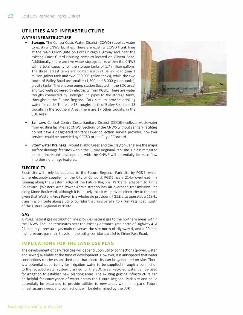
62 East Bay Regional Parks District
Existing conditions report
uTiliTieS AND iNfRASTRuCTuRe WATeR iNfRASTRuCTuRe
• Storage. The Contra Costs Water District (CCWD) supplies water to existing CNWS facilities. There are existing CCWD trunk lines at the main CNWS gate on Port Chicago Highway and near the existing Coast Guard Housing complex located on Olivera Road. Additionally, there are five water storage tanks within the CNWS with a total capacity for the storage tanks of 1.7 million gallons. The three largest tanks are located north of Bailey Road (one 1 million gallon tank and two 350,000 gallon tanks), while the two south of Bailey Road are smaller (1,500 and 5,000 gallon tanks), gravity tanks. There is one pump station (located in the EDC area) and two wells powered by electricity from PG&E. There are water troughs connected by underground pipes to the storage tanks, throughout the Future Regional Park site, to provide drinking water for cattle. There are 13 troughs north of Bailey Road and 13 troughs in the Southern Area. There are 17 other troughs in the EDC Area.
• Sanitary. Central Contra Costa Sanitary District (CCCSD) collects wastewater from existing facilities at CNWS. Sections of the CNWS without sanitary facilities do not have a designated sanitary sewer collection service provider; however services could be provided by CCCSD or the City of Concord.
• Stormwater drainage. Mount Diablo Creek and the Clayton Canal are the major surface drainage features within the Future Regional Park site. Unless mitigated on-site, increased development with the CNWS will potentially increase flow into these drainage features.
eleCTRiCiTyElectricity will likely be supplied to the Future Regional Park site by PG&E, which is the electricity supplier for the City of Concord. PG&E has a 21-kv overhead line running along the western edge of the Future Regional Park site, adjacent to Kinne Boulevard. (Western Area Power Administration has an overhead transmission line along Kinne Boulevard, although it is unlikely that it will provide electricity to the park given that Western Area Power is a wholesale provider). PG&E also operates a 115-kv transmission route along a utility corridor that runs parallel to Kirker Pass Road, south of the Future Regional Park site.
gaSA PG&E natural gas distribution line provides natural gas to the northern areas within the CNWS. The line terminates near the existing entrance gate north of Highway 4. A 24-inch high-pressure gas main traverses the site north of Highway 4, and a 20-inch high-pressure gas main travels in the utility corridor parallel to Kirker Pass Road.
iMPliCATiONS fOR THe lAND uSe PlANThe development of park facilities will depend upon utility connections (power, water, and sewer) available at the time of development. However, it is anticipated that water connections can be established and that electricity can be generated on-site. There is a potential opportunity for irrigation water to be supplied through a connection to the recycled water system planned for the EDC area. Recycled water can be used for irrigation to establish new planting areas. The existing grazing infrastructure can be helpful for conveyance of water across the Future Regional Park site and could potentially be expanded to provide utilities to new areas within the park. Future infrastructure needs and connections will be determined by the LUP.
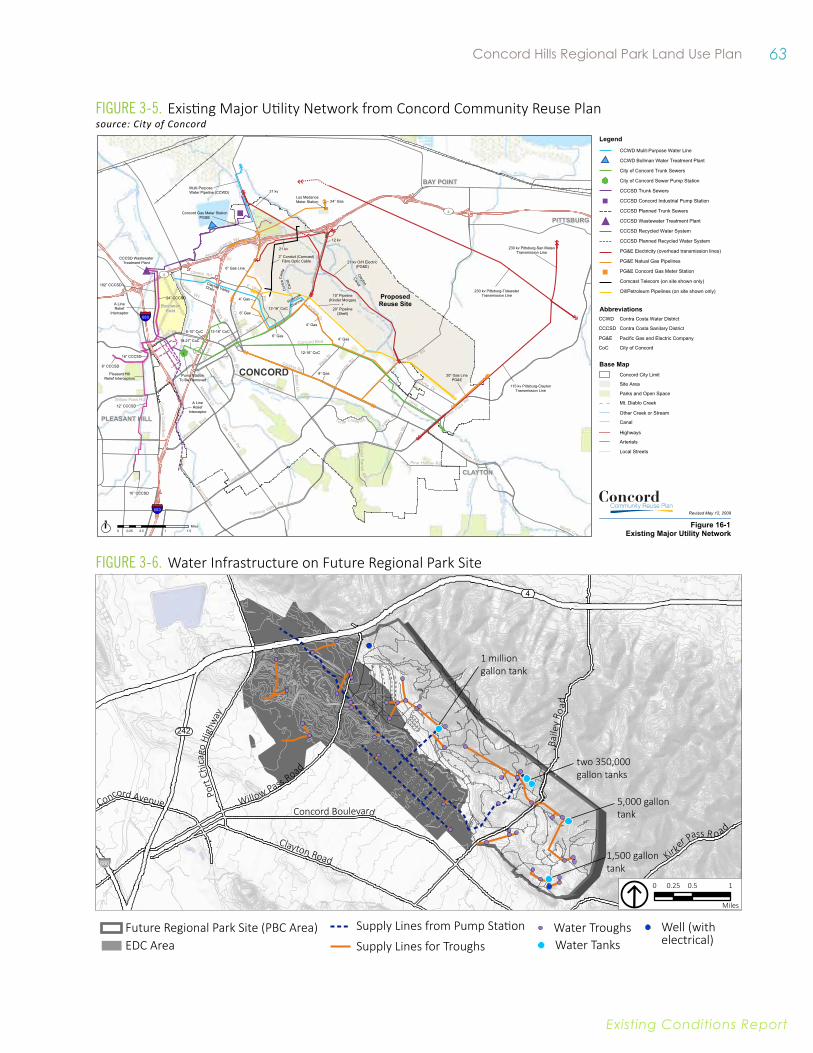
63 Concord Hills Regional Park Land Use Plan
Existing conditions report
Willow Pass Road
Concord Boulevard
Clayton Road
Baile
y Ro
ad
Kirk
er Pass R oad
Concord Avenue
%&'(680
4
242
Port
Chi
cago
Hig
hway
5,000 gallon tank
1,500 gallon tank
two 350,000 gallon tanks
1 million gallon tank
0 0.5 10.25
Miles
EDC AreaFuture Regional Park Site (PBC Area) Supply Lines from Pump Station
Supply Lines for TroughsWater Troughs Well (with
electrical) Water Tanks
Figure 3-6. Water Infrastructure on Future Regional Park Site
Figure 3-5. Existing Major Utility Network from Concord Community Reuse Plansource: City of Concord
BuchananField
ProposedProposedReuse SiteReuse Site
Bancroft Rd
Clayton Rd
Marsh Creek Rd
4
Cowell Rd
Bailey Rd
Contra
Co sta
Blvd
Oak Grove
Rd
Concord Blvd
Clayton Rd
Arnold Indu
strial Wy
E Olivera R
d
Ay
ers
Rd
Pine Hollow Rd
Kirker Pass Rd
Solano
Wy
Myrtle Dr
UV4
UV242
§̈¦680W
illow
Pass
Rd
Ygnac io Valley Rd
Albe
rta W
y
Tu rtle Creek Rd
Olive Dr
Monument Blvd
Bates Av
Landana
Dr
Cr ys tyl
Ra nc h
R
d
Mar
ket S
tConcord Av
Detroit Av
Wes
t St
Denkin
ger Rd
Meadow
Ln
Salvio
St
Olivera Rd
Treat Blvd
Willow Pass Rd
Babel Ln
Galindo
St
Grant
St
Port C
hicago H
wy
East St
UV4
§̈¦680
CONCORD
BAY POINTBAY POINT
PITTSBURGPITTSBURG
Wi l low Cree k
Do
nner
Cre
ek
Pacheco
Creek
Mit
c hel
l C
reek
Vine
Hil
l
C r eek
Pac heco
Cr eek
P ine C
reek
Mt. Diablo
Creek
GalindoCreek
Walnut
Creek
PLEASANT HILLPLEASANT HILL
CLAYTONCLAYTON
N
0 0.5 1 1.50.25Miles
Base MapConcord City Limit
Site Area
Parks and Open Space
Canal
Mt. Diablo Creek
Other Creek or Stream
Highways
Arterials
Railroad
Figure X-XTitle
Items
Legend
Revised April 30, 2008
Text 6 pt
Notes & Sources
21 kvMulti-PurposeWater Pipeline (CCWD)
Concord Gas Meter StationPG&E
24” GasLos MedanosMeter Station
21 kv
12 kv
21 kv O/H Electric(PG&E)
2” Conduit (Comcast)Fibre Optic Cable
6” Gas Line
4” Gas
6” Gas12-16” CoC
10” Pipeline(Kinder Morgan)
+20” Pipeline
(Shell)
12-16” CoC
4” Gas
4” Gas
8” Gas 20” Gas LinePG&E
115 kv Pittsburg-ClaytonTransmission Line
230 kv Pittsburg-San MateoTransmission Line
230 kv Pittsburg-TidewaterTransmission Line
Pump StationTo Be Removed
A LineRelief
Interceptor
Pleasant HillRelief Interceptors
10” CCCSD
12” CCCSD
8” CCCSD
16” CCCSD
102” CCCSD
24” CCCSD
CCCSD WastewaterTreatment Plant
18-27” CoC
8-10” CoC 12-16” CoC
A LineRelief
Interceptor
6” Gas
Con
traC
osta
Can
al
Clayton
CanalClayton ValleyDrain
Holbrook
Channel
Legend
Contra Costa Water DistrictCCWD
Contra Costa Sanitary DistrictCCCSD
Pacific Gas and Electric CompanyPG&E
City of ConcordCoC
Base MapConcord City Limit
Site Area
Parks and Open Space
Mt. Diablo Creek
Other Creek or Stream
Canal
Highways
Arterials
Local Streets
CCWD Mulit-Purpose Water Line
CCWD Bollman Water Treatment Plant
City of Concord Trunk Sewers
City of Concord Sewer Pump Station
CCCSD Trunk Sewers
CCCSD Concord Industrial Pump Station
CCCSD Planned Trunk Sewers
CCCSD Wastewater Treatment Plant
CCCSD Recycled Water System
CCCSD Planned Recycled Water System
PG&E Electricity (overhead transmission lines)
PG&E Natual Gas Pipelines
PG&E Concord Gas Meter Station
Comcast Telecom (on site shown only)
Oil/Petroleum Pipelines (on site shown only)
Abbreviations
Figure 16-1Existing Major Utility Network
Revised May 12, 2009
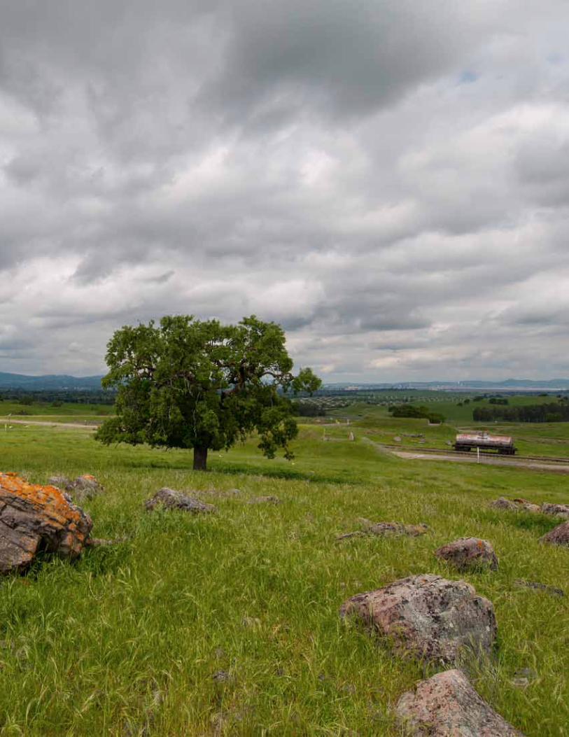
64
East bay regional parks district concord Hills regional park Land Use plan
Existing Conditions Report
65
East bay regional parks district concord Hills regional park Land Use plan
Existing Conditions Report
4. oPPoRtUnItIEs anD ConstRaInts The expansive Future Regional Park site provides a rich canvas for the development of a world-class regional park. The Park Land Use Plan must identify a synergistic relationship between envisioned recreational and educational uses and the site’s existing ecological and cultural resources.
As discussed in detail in Chapters Two and Three, the Future Regional Park site’s existing resources and dynamic context set the stage for a unique park and indicate abundant possibilities.
This Chapter provides a consolidated summary of key opportunities and constraints based on the more detailed, topic-based, discussion in Chapter Three. Major on-the-ground opportunities and constraints are shown in Figure 4.1. Key opportunities, which that are anticipated to be most critical in helping shape a world class open space, recreational, and interpretive resource are summarized below.
The Future Regional Park site has the potential to offer:
oPEn sPaCE tHat Is HIgHLy aCCEssIBLE to URBan PoPULatIons The possibility of accessing the Future Regional Park site by BART will make this a “one-of-a-kind” open space property of the District: one that is accessible to a large urban population via mass transit. Transit and trail connections to the Park can reduce barriers to open space and park access experienced by many urban dwellers, including access to private vehicles. The site also has the potential to become very accessible from SR4 and the regional highway system, allowing visitors to access the site from a range of destinations more quickly and more easily than many of the District’s other parks.
Furthermore, the Future Regional Park site’s topography and open landscapes have the potential to support a range of recreational uses and appeal to a diverse population of users. While the steep hillsides are well suited to challenging trail experiences, the gentle slopes that stretch from the hills towards Mt. Diablo Creek can provide level-ground for numerous low-impact recreational facilities such as picnic grounds and gathering areas that are accessible by vehicle or by trails that comply with federal accessibility standards.

66 East Bay Regional Parks District
Existing conditions report
Figure 4-1. Opportunities and Constraints
Gentle (0-10%)Moderate Road Grade (10-15%)Moderately Steep Road Grade (15-20%)Steep Road Grade (>20%)
Existing Roads Suitability
CanalEphemeral and Intermittent Streams
Mount Diablo CreekWaterways
Relatively Flat (0-5%)Gentle Slopes
Mild (5-10%)
Other Perennial Creeks
Railroad TracksRidgeline
10’ Contours50’ Contours
BART LineBart StationRemediation Areas
Future Regional Park SiteEDC Area 0.25 mile buffer for Golden Eagle Nest
Habitat Buffers
100ft buffer for CTS/CRLF Breeding Ponds300ft buffer for CTS/CRLF Breeding Ponds200ft buffer for Coastal Sage Scrub
Interpretive Opportunities1. Views towards Port Chicago Vicinity (Building 87)2. Historic Magazine Areas (Creative Reuse Potential)3. Building IA-24 and Cattle Corral4. Cistern Building5. Experimental Forests6. Former Orchard Site
#
Key Viewpoints
Operations Opportunities**
Non-vehicular Access
Vehicular Access
Existing Trails Future Trails

67 Concord Hills Regional Park Land Use Plan
Existing conditions report
2
3
45
5 2
6
1
**
**
**
4
Bailey Road
Concord Boulevard
Clayton Road
Will
ow P
ass
Road
Delta-DeAnza Trai l
K inne Boule vard
Mount Di abl o C r eek
C l ayt
on Canal
C o ntra Cos t a Can al
0 0.25 0.50.125
Miles
Connection to North Concord
BART Station
Connection to B lack Diamond Mines and Mount Diablo
Connection
to P
ittsburg
Connection to North Concord
BART Station
Connection to B lack Diamond Mines and Mount Diablo
Connection
to P
ittsburg
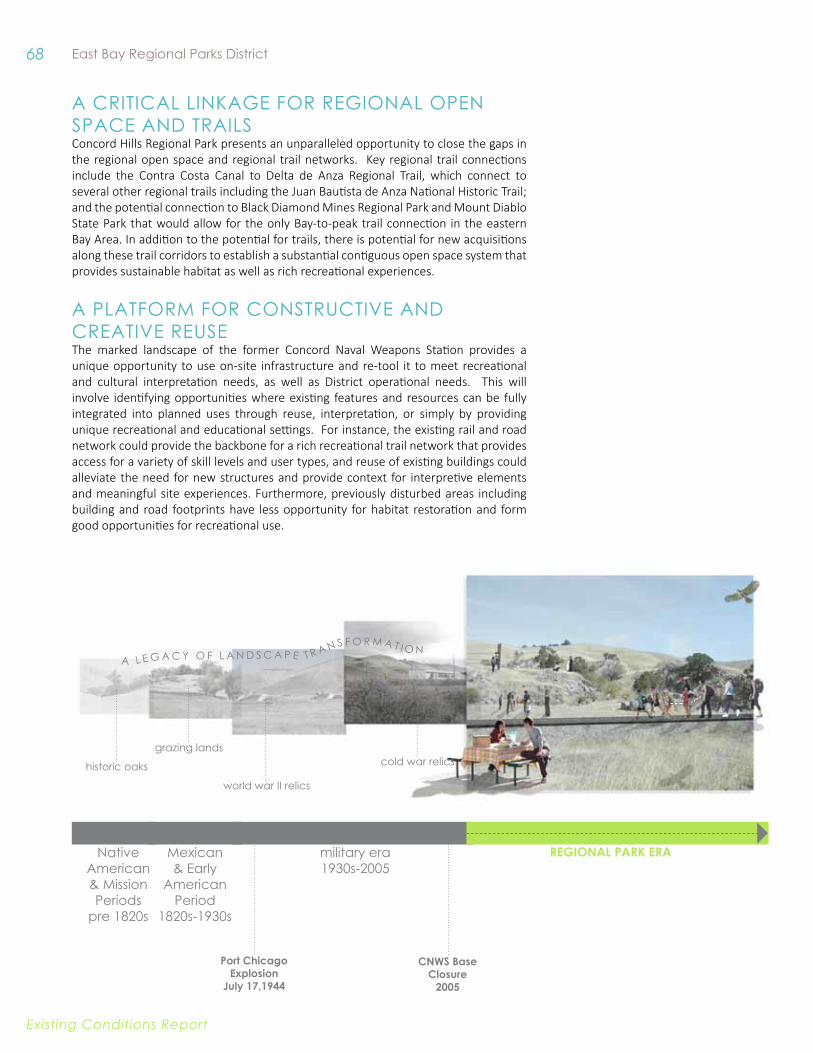
68 East Bay Regional Parks District
Existing conditions report
a CRItICaL LInkagE foR REgIonaL oPEn sPaCE anD tRaILs Concord Hills Regional Park presents an unparalleled opportunity to close the gaps in the regional open space and regional trail networks. Key regional trail connections include the Contra Costa Canal to Delta de Anza Regional Trail, which connect to several other regional trails including the Juan Bautista de Anza National Historic Trail; and the potential connection to Black Diamond Mines Regional Park and Mount Diablo State Park that would allow for the only Bay-to-peak trail connection in the eastern Bay Area. In addition to the potential for trails, there is potential for new acquisitions along these trail corridors to establish a substantial contiguous open space system that provides sustainable habitat as well as rich recreational experiences.
a PLatfoRM foR ConstRUCtIvE anD CREatIvE REUsE The marked landscape of the former Concord Naval Weapons Station provides a unique opportunity to use on-site infrastructure and re-tool it to meet recreational and cultural interpretation needs, as well as District operational needs. This will involve identifying opportunities where existing features and resources can be fully integrated into planned uses through reuse, interpretation, or simply by providing unique recreational and educational settings. For instance, the existing rail and road network could provide the backbone for a rich recreational trail network that provides access for a variety of skill levels and user types, and reuse of existing buildings could alleviate the need for new structures and provide context for interpretive elements and meaningful site experiences. Furthermore, previously disturbed areas including building and road footprints have less opportunity for habitat restoration and form good opportunities for recreational use.
military era1930s-2005
Mexican & Early
american Period
1820s-1930s
native american & Mission Periods
pre 1820s
cold war relics
world war II relics
grazing lands
historic oaks
REGIONAl PARK ERA
a L E g a C y o f L a n D s C a P E t R a n s f o R M a t I o n
Port Chicago Explosion
July 17,1944
CNWS Base Closure
2005
69 Concord Hills Regional Park Land Use Plan
Existing conditions report
a HIstoRIC anD ECoLogICaL LanDsCaPE tHat REsonatEs The Future Regional Park site offers multiple opportunities to engage contemporary users with the site’s rich cultural and ecological history by highlighting the unique features and through interpretive programming. These on-site resources range from watershed-scale views to perennial creeks, and from monumental buildings to fading remnants.
In addition to the on-site features that suggest compelling narratives, the proximity and views of the Tidal area of the CNWS, and therefore the vicinity of the Port Chicago Memorial, combined with the NPS and District partnership create an important opportunity for visitors to learn about Port Chicago as an emblem of racial discrimination, courage and the fight for civil rights.
a sUstaInaBLE PaRk MoDELConcord Hills Regional Park has the opportunity to become a new model for a sustainable regional park. Reaching beyond the protection of natural resources, it offers opportunities to create new habitat, harboring endangered and sensitive species immediately adjacent to urban development. It can serve as a model for creating an urban-nature interface, with potential to provide recreation opportunities immediately adjacent to planned development. A key opportunity also exists to accommodate and encourage non-vehicular access, including transit, pedestrian, and bicycle access to the park.
In addition to an emphasis on resource protection, including views, the park will be a living demonstration area for ecological and sustainable practices, including the use of grazing as a tool for active restoration, soil management, and fire protection. The park is also an opportunity to showcase sustainable design and construction practices, from on-site energy production and energy-efficient building design to on-site stormwater capture and treatment.
ConCord Hills regional Parkland use Plan
E x i s t i n g c o n d i t i o n s r E p o r tJuly 20, 2015