Embed Size (px)
Citation preview
CONJUNCTIVE USE AND MANAGEMENT OF SURFACE AND GROUNDWATER RESOURCES IN IRRIGATION SECTOR
*Sudhakar Pathak, Abhishek Saxena
Faculty of Civil Engineering,Shri Ramswaroop Memorial University, Barabanki, Uttar Pradesh, India
Conjunctive use of groundwater and surface water in an irrigation setting is the process of using water from two different sources for consumptive purpose. Conjunctive use can refer to the practice at the farm level of sourcing water from both well and irrigation canal or it is an approach at irrigation command level where surface and ground water inputs are centrally managed as an input to irrigation system. Typically, water has been sourced either surface or ground water supplies with primary supply supplemented by alternative source over time.
Increasing demand and decreasing water quality has put enormous pressure on the agriculture sector to use its available water resources more efficiently. These pressures are a result of the increasing demand for food and inter-sect oral competition for water, particularly from the municipal and industrial sector. Therefore, in future, irrigation's contribution to food security will largely depend on the use of low-quality water
in agriculture in addition to renewing efforts to achieve water conservation. Without assured irrigation supplies, these arid and semiarid areas of India cannot support any agriculture, as the evaporation- transpiration demand is high and rainfall is either very less or unreliable. The operation of the Indo-Gangetic plain irrigation system is based on a continuous water supply and is not related to actual crop water requirements. Irrigation canals are usually not allocated more than their design capacity.Despite significant increase in storage capacities, it is essentially a supply-based sys tem. Hence , i t cannot adequatelyaccommodate changing water demands during the crop season. The system was originally designed for an annual cropping intensity (i.e., yearly cropped area) of about 75 percent with the intention to spread the irrigation water over as large an area as possible to expand the settlement opportunities. The major objective of irrigation development at that time was to prevent crop
*Address for Correspondence: Sudhakar Pathak, Faculty of Civil Engineering, Shri Ramswaroop Memorial University, Barabanki, Uttar Pradesh, India,
E mail : [email protected]
ABSTRACT
The work presents GIS based integrated modelling, which integrates soil moisture accounting and irrigation water requirement, rainfall–runoff, system loss and groundwater flow system. Developed model is employed to evaluate different water management scenarios such as change in rainfall sequence (wet, normal and dry season), change in canal water supply, impact of land use changes including their socio–economic implications. The application of model is illustrated with real application in a part of Indo-Gangetic plain of Uttar Pradesh in India.In this paper different modes of irrigation are assessed and compared them with conjunctive use of surface and groundwater. The data used in this study was collected from different department e.g. Irrigation Department ,U.P.Lucknow, Sawara Lucknow and Ground water Department Lucknow. The results highlighted the problem of increased use of tube well water in the saline groundwater zones that had resulted in the deterioration of the soils and groundwater quality, which has led to the problem of up coning of saline groundwater. Conjunctive water management in crop increased the farm income, compared to only using the canal and tube well water, respectively. The model optimization results showed that it is possible to increase the total gross margins while keeping the salinity levels and the changes in depth to water table in the acceptable limits through conjunctive water management.
INTRODUCTION
82
International Journal of Scientific and Innovative Research 2017; 5(1) : 82‐87P‐ISSN 2347‐2189, E‐ ISSN 2347‐4971
www.ijsir.co.in

failure and avoid famine (Jurriens and Mollinga). At the resource level, groundwater pumping for irrigation used in conjunction with surface water provides benefits that increase the water supply or mitigate undesirable fluctuations in the supply (Tsur, 1990) and control shallow water table levels and consequent soil salinity.This paper explores the reasons underpinning the apparent poor approach to full integration in the management and use of both water sources, and the absence of more coordinated planning. In most climates around the world, precipitation, and consequently peak river discharge, occurs during a particular season of the year, whereas crop irrigation water requirements are at their greatest during periods of low rainfall when unregulated stream flows are significantly lower. For many irrigation systems, water supply is aligned with crop water requirements through the construction and management of dams which capture water during periods of high flow, enabling regulated releases to meet crop water requirements.However, the construction, operation and distribution of water from dams are inherently costly undertakings. Furthermore, dams and the associated distribution systems are commonly subject to high system losses through evaporation and leakage, and they have social and ecological impacts upon communities and the environment in and on which they are built. Conversely, under natural recharge regimes, groundwater storage requires no infrastructure, the aquifer serving as the natural distribution system. The point of irrigation, in a groundwater-fed irrigation command, is mostly opportunistically located close to the groundwater extraction point, which in turn is integrated into on-farm irrigation infrastructure. Under a sus ta inable ext rac t ion regime, groundwater of a suitable quality can provide a reliable source of water either as a sole supply of
water, or to supplement alternative sources.These specific characteristics of surface and g roundwate r r e sources have impor t an t implications for the optimal design and operation of irrigation systems. At the general level the benefits attributed to optimizing conjunctive use of surface and groundwater have been investigated over many years through theoretical modelling and studies of physical systems. These benefits take the form of economic gains, increase in productivity, energy savings, and increased capacity to irrigate via larger areas, water resource efficiency and infrastructure optimization.
STUDY AREAThe Study area is Daulatpur distributaries of Tilloi block District Amethi (between latitudes 26◦17_and 26◦24 and longitudes 81◦23and 81◦29) .The length of canal is 17.85 km. and it is taking off from km 27.14(R) of Jaunpurbranch. The discharge is 39.00 cusec; G.C.A. and C.C.A. are 3709.16 Hectare meter and 3328.82 Hectare meter respectively.Present study area is part of Ghaghara Gomti - basin. This work developed integrated framework and demonstrated its application in canal network of Daulatpur distributaries system.
• The main problem of this area is water logging and salinity.
• The recharge of the aquifer due to seepage from the (canals of the) irrigation system is considered as the main cause of drainage problem.
• Ground water management has been accorded a low priority.
• The farmers of tail portion of canal are not getting required quantity of water as per demand of different crops.
83
International Journal of Scientific and Innovative Research 2017; 5(1) : 82‐87P‐ISSN 2347‐2189, E‐ ISSN 2347‐4971
www.ijsir.co.in

Water logged Area of Daulatpur Distributaries
RESULTS AND DISCUSSION On the basis of Data collected from Irrigation Department, U.P., Swara and Ground Water
Department, U.P., graphs are plotted as mentioned below:
Ground Water Level and Annual Rainfall
84
International Journal of Scientific and Innovative Research 2017; 5(1) : 82‐87P‐ISSN 2347‐2189, E‐ ISSN 2347‐4971
www.ijsir.co.in
Graphs between time period (Years) and ground water level and annual Rainfall (m.)
Analysis of Graph Graphs are plotted on the basis of secondary data of Groundwater, which is obtained from Swara office Lucknow. The graph drawn shows that as we move from year 1998 to 2015 there is general increase in depth of Ground water (PRM). This indicates the increase in tendency of over exploitation of ground water which must be checked. Similarly in the case of (PTM) also there is tendency of increase in depth of ground water. This may be due to over extraction of ground water and as well as it may be due to less rainfall during that period.
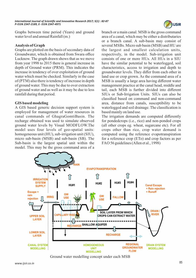
GIS based modelingA GIS based generic decision support system is employed for management of water resources in canal commands of GhagraGomtiBasin. The recharge obtained was used to simulate observed ground water levels by Visual MODFLOW.The model uses four levels of geo-spatial units: homogeneous unit (HU), sub-irrigation unit (SIU), micro sub-basin (MSB) and sub-basin (SB). The Sub-basin is the largest spatial unit within the model. This may be the gross command area of a
branch or a main canal. MSB is the gross command area of a canal, which may be either a distributaries or a branch canal. A sub-basin may consist of several MSBs. Micro sub basin (MSB) and HU are the largest and smallest calculation units, respectively, in the model. Sub-irrigation unit consists of one or more HUs. All HUs in a SIU have the similar potential to be waterlogged, soil characteristics, access to irrigation and depth to groundwater levels. They differ from each other in land use or crop grown. As the command area of a MSB is usually a large area having different water management practice at the canal head, middle and tail, each MSB is further divided into different SIUs or Sub-Irrigation Units. SIUs can also be classified based on command and non-command area, distance from canals, susceptibility to be waterlogged and soil drainage. The classification is based mainly on land use.The irrigation demands are computed differently for pondedcrops (i.e., rice) and non-ponded crops (all other crops eg. wheat, sugarcane etc). For all crops other than rice, crop water demand is computed using the reference evapotranspiration for a reference crop (ETo) and crop factors as per FAO 56 guidelines (Allen et al., 1998)
Ground water modelling concept under each MSB
85
International Journal of Scientific and Innovative Research 2017; 5(1) : 82‐87P‐ISSN 2347‐2189, E‐ ISSN 2347‐4971
www.ijsir.co.in

Daulatpurdistributaury System and its Command
Recharge from rainfall(As per Ground water resources estimation committee norms (G.E.C.)
0.4Rr= 2.0 (P - 15)
0.5Rr =1.35 (P - 14)Where, Rr = net recharge due to precipitation during the year, in inches; P = annual precipitation, in inchesRecharge from Canal SeepageRcmax= K (B + 2D) (in case of deeper water table) Rcmin= K (B -2D) (in case of shallow water table)Where B is width of canal, D is depth of flow and K is hydraulic conductivity of the bed material CONCLUSIONThe work presented a framework for agricultural canal system simulation and management in Indo-Gangetic plains of Uttar Pradesh in India. Model results demonstrate potential applicability of the methodology in large canal systems. Following conclusions may be drawn from the study .The canal water use efficiency may increase with decrease in rainfall or canal water supply resulting in increased ground water use or depletion in ground water reservoir for the same cropping
pattern and intensity. At the same time with the increase in rainfall or canal water supply, the canal water use efficiency may decreases but the ground water depletion is reduced. By opting conjunctive use of surface and groundwater in Daualatpur distributaries command, the water use efficiency of canal water may increase up to58%. For the normal rainfall sequence of 847.3 mm per year and canal supply of 314.4 mm per year in Daulatpur distributary system, canal water use efficiency increases to 40.7% against 37.3%, while the depletion in ground water level increases to 19 cm per year in place of 18 cm per year in case of present cropping intensity of 130% (of command area).It clearly indicates that depletion in ground water levels is directly related to proposed cropping pattern/cropping intensity and it reduces with increase in rainfall or increase in canal water supply or with the proposal of less water requiring crops. However, this depletion in ground water level can be maintained more effectively at constant level with implementation of conjunctive use at Kulawa command level to bring more area under cultivation and saving energy cost in tail commands.
86
International Journal of Scientific and Innovative Research 2017; 5(1) : 82‐87P‐ISSN 2347‐2189, E‐ ISSN 2347‐4971
www.ijsir.co.in

REFERENCES1. Jehangir, W.A; Qureshi,A.; Ali,N.2002
conjunctive water management in the Rechna Doab .
2. Allen, R.G., Pereira, L.S., Raes, D., Smith, M., 1998. FAO Irrigation and Drainage Paper No. 56 Crop evapotranspiration (guidelines for computing crop water requirements), FAO, Rome, Italy (ISBN 92-5-104219-5).
3. Bansal, A.K., Raut, A.K., Srivastava, P.K., 2012. Canal simulation model for conjunctive irrigation management. Water Energy Int. 69 (11), 45–51 (ISSN:0974-4207).
4. Basu, A.N., 1971. Fitting of a Markov chain model for daily rainfall data at Calcutta.Indian J. Meteorol. Geophys. 22, 67–74
5. .Brouwer C., Hoevenaars, J.P., Bosch, B. E. Van and Hatcho, N. 1992. Canals.Irrigation Water management Training manual no.7.FAO
6. Chowdhury, A., Jha, M.K., Chowdary, V.M., Mal, B.C., 2009. Integrated remote sensing and GIS-based approach for assessing groundwater potential in West Medinipur district, West Bengal,India. IntJ. Remote Sens. 30 (1), 231–250,http://dx.doi.org/10.1080/01431160802270131
7. Handbook of Hydrology (1972). Soil Conservation Department, Ministry of Agriculture, New Delhi, India.
8. Heinemann, P.H. (2010). Decision support system for food and agriculture. System analysis and modeling in food and agriculture, Encyclopedia of life support system (EOLSS), U N E S C O - E O L S S J o i n t C o m m i t t e e Secretariat, UNESCO, SC/PSB- 1 rue Miollis, 75732 Paris, France.
9. Kumbhar, V.G., Singh, T.P., 2013. A systematic study of application of spatial decision support
system in agriculture. Int. J. Sci. Eng. Res. 4 (12), 68–71 (ISSN2229-5518)
10. Levidow, L., Zaccaria, D., Maia, R., Vivas, E., Todorovic, M., Scardigno, A., 2014.Improving water-efficient irrigation: prospects and difficulties of innovative practices. Agric. Water Manage. 146, 84–94
11. Reddy, M.N., Rao, N.H., 1995. 1995, GIS B a s e d D e c i s i o n S u p p o r t S y s t e m s inAgr icu l tu re . Na t iona l Academy of A g r i c u l t u r a l R e s e a r c h M a n a g e m e n t Rajendranagar, 1–11 Santhi, C., Muttiah, R.S., Arnold, J.G., Srinivasan, R., 2005.
12. A GIS-based regional planning tool for irrigation demand assessment and savings using SWAT.Trans. ASAE 48 (1), 137–147 (American Society of Agricultural Engineers ISSN0001-2351).
13. Simons, M., Podger, G., Cooke, R., 1996. IQQM—a hydrologic modeling tool for water r e sou rce and s a l i n i t y managemen t ' . Environmental Software, vol. 11,nos. 1-3, 185–192 .Stafford, D.B. (Ed.), 1991. ASCE, New York SMEC (2010).
14. Final Report for JBS and HBS – Preparation of GhaghraGomti Basin Plans & Development of Decision Support System. SMEC International Pty Ltd. Subramanian, K., 2013. Engineering Hydro logy. McGraw Hi l l Educa t ion (India)Private Limited, New Delhi.
15. Wa t e r l o o h y d r o l o g i c , 2 0 0 2 . Vi s u a l MODFLOW v.3.0.0 User's Manual, Ontario, Canada.Water Technology Centre, 1998. Development of guidelines for sustainable water management in irrigation projects. In: Cont r ibu t ions to Wate r Sc ience and Technology. IARI, New Delhi.
87
International Journal of Scientific and Innovative Research 2017; 5(1) : 82‐87P‐ISSN 2347‐2189, E‐ ISSN 2347‐4971
www.ijsir.co.in