Embed Size (px)
Citation preview
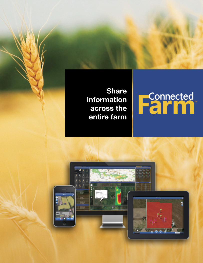
Share information across the entire farm
dashboard
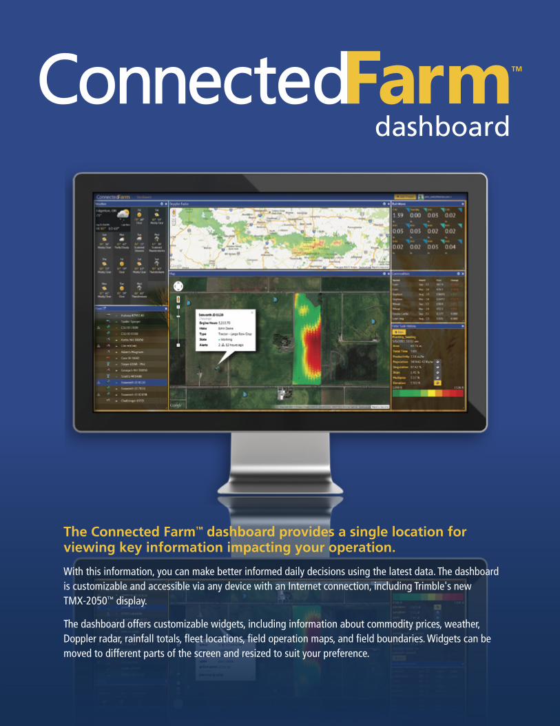
The Connected Farm™ dashboard provides a single location for viewing key information impacting your operation.
With this information, you can make better informed daily decisions using the latest data. The dashboard is customizable and accessible via any device with an Internet connection, including Trimble's new TMX-2050™ display.
The dashboard offers customizable widgets, including information about commodity prices, weather, Doppler radar, rainfall totals, fleet locations, field operation maps, and field boundaries. Widgets can be moved to different parts of the screen and resized to suit your preference.
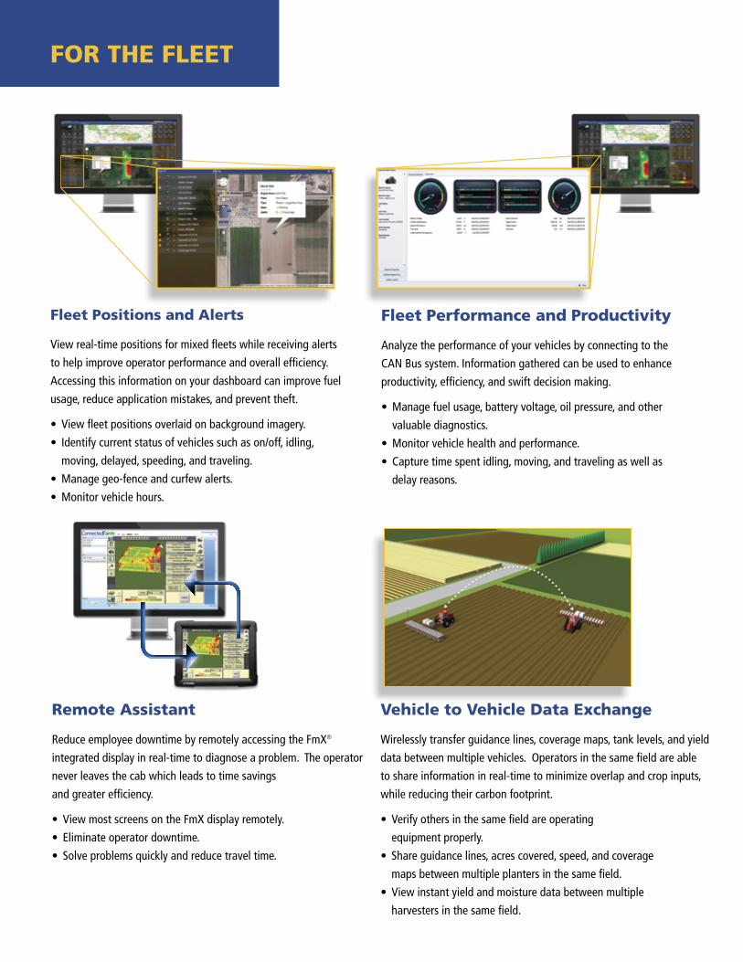
Fleet Positions and Alerts
View real-time positions for mixed fleets while receiving alerts
to help improve operator performance and overall efficiency.
Accessing this information on your dashboard can improve fuel
usage, reduce application mistakes, and prevent theft.
• View fleet positions overlaid on background imagery.
• Identify current status of vehicles such as on/off, idling,
moving, delayed, speeding, and traveling.
• Manage geo-fence and curfew alerts.
• Monitor vehicle hours.
Fleet Performance and Productivity
Analyze the performance of your vehicles by connecting to the
CAN Bus system. Information gathered can be used to enhance
productivity, efficiency, and swift decision making.
• Manage fuel usage, battery voltage, oil pressure, and other
valuable diagnostics.
• Monitor vehicle health and performance.
• Capture time spent idling, moving, and traveling as well as
delay reasons.
Remote Assistant
Reduce employee downtime by remotely accessing the FmX® integrated display in real-time to diagnose a problem. The operator
never leaves the cab which leads to time savings
and greater efficiency.
• View most screens on the FmX display remotely.
• Eliminate operator downtime.
• Solve problems quickly and reduce travel time.
Vehicle to Vehicle Data Exchange
Wirelessly transfer guidance lines, coverage maps, tank levels, and yield
data between multiple vehicles. Operators in the same field are able
to share information in real-time to minimize overlap and crop inputs,
while reducing their carbon footprint.
• Verify others in the same field are operating
equipment properly.
• Share guidance lines, acres covered, speed, and coverage
maps between multiple planters in the same field.
• View instant yield and moisture data between multiple
harvesters in the same field.
FOR thE FLEEt
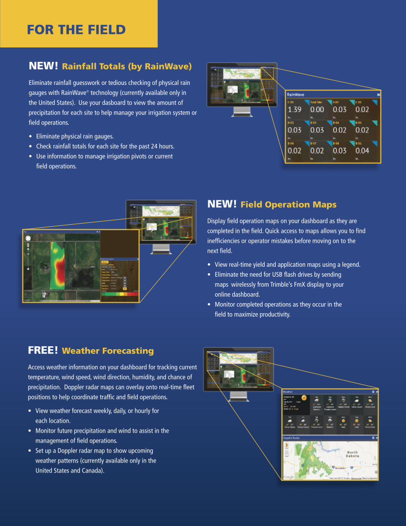
NEW! Rainfall totals (by RainWave)
Eliminate rainfall guesswork or tedious checking of physical rain
gauges with RainWave® technology (currently available only in
the United States). Use your dasboard to view the amount of
precipitation for each site to help manage your irrigation system or
field operations.
• Eliminate physical rain gauges.
• Check rainfall totals for each site for the past 24 hours.
• Use information to manage irrigation pivots or current
field operations.
NEW! Field Operation Maps
Display field operation maps on your dashboard as they are
completed in the field. Quick access to maps allows you to find
inefficiencies or operator mistakes before moving on to the
next field.
• View real-time yield and application maps using a legend.
• Eliminate the need for USB flash drives by sending
maps wirelessly from Trimble’s FmX display to your
online dashboard.
• Monitor completed operations as they occur in the
field to maximize productivity.
FREE! Weather Forecasting
Access weather information on your dashboard for tracking current
temperature, wind speed, wind direction, humidity, and chance of
precipitation. Doppler radar maps can overlay onto real-time fleet
positions to help coordinate traffic and field operations.
• View weather forecast weekly, daily, or hourly for
each location.
• Monitor future precipitation and wind to assist in the
management of field operations.
• Set up a Doppler radar map to show upcoming
weather patterns (currently available only in the
United States and Canada).
FOR thE FIELD
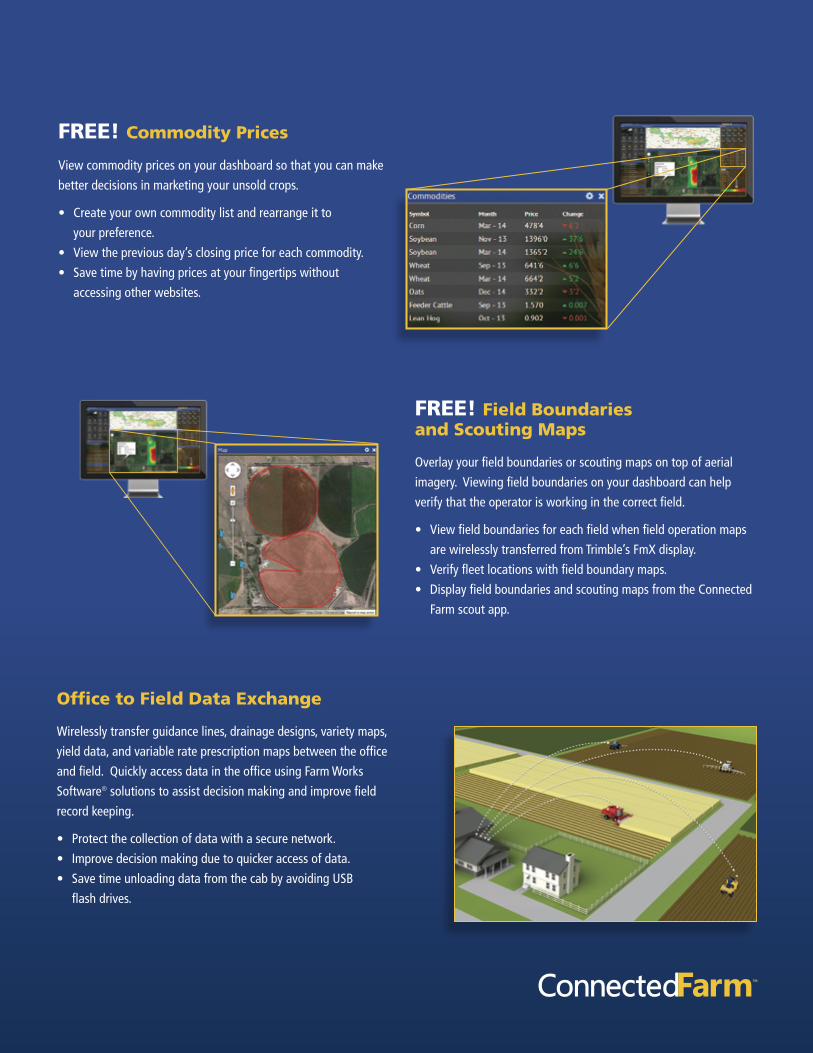
FREE! Commodity Prices
View commodity prices on your dashboard so that you can make
better decisions in marketing your unsold crops.
• Create your own commodity list and rearrange it to
your preference.
• View the previous day’s closing price for each commodity.
• Save time by having prices at your fingertips without
accessing other websites.
FREE! Field Boundaries and Scouting Maps
Overlay your field boundaries or scouting maps on top of aerial
imagery. Viewing field boundaries on your dashboard can help
verify that the operator is working in the correct field.
• View field boundaries for each field when field operation maps
are wirelessly transferred from Trimble’s FmX display.
• Verify fleet locations with field boundary maps.
• Display field boundaries and scouting maps from the Connected
Farm scout app.
Office to Field Data Exchange
Wirelessly transfer guidance lines, drainage designs, variety maps,
yield data, and variable rate prescription maps between the office
and field. Quickly access data in the office using Farm Works
Software® solutions to assist decision making and improve field
record keeping.
• Protect the collection of data with a secure network.
• Improve decision making due to quicker access of data.
• Save time unloading data from the cab by avoiding USB
flash drives.
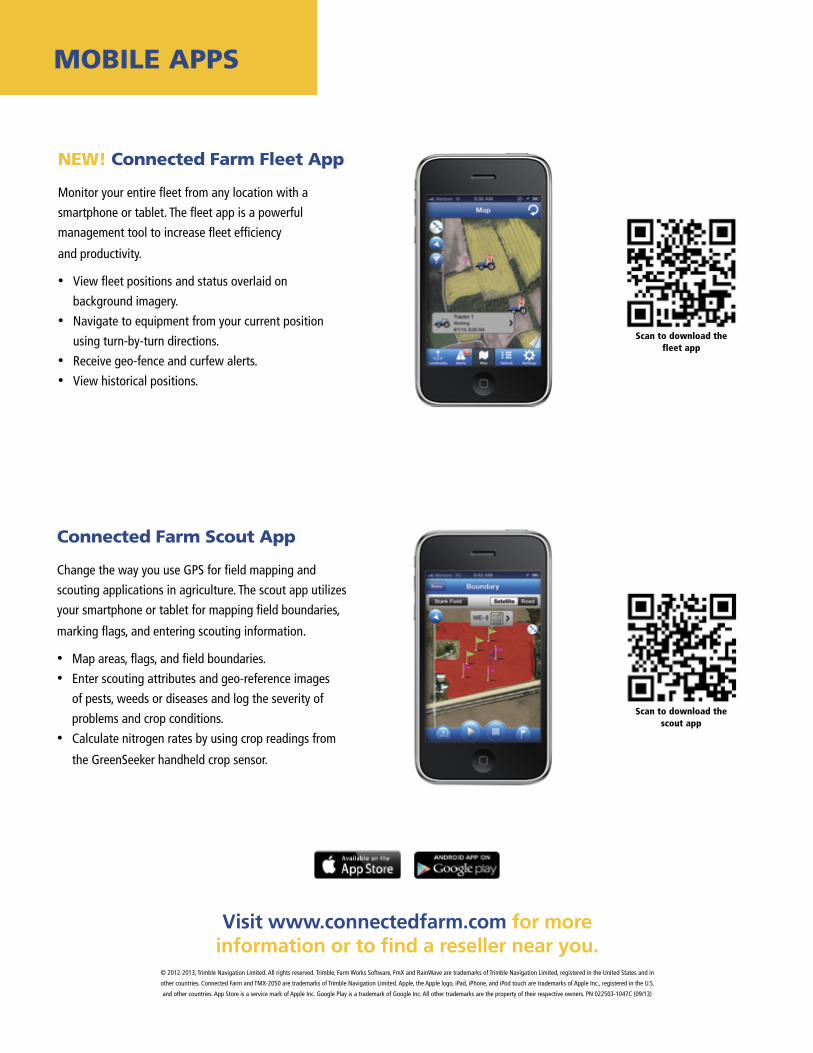
MOBILE APPS
Visit www.connectedfarm.com for more information or to find a reseller near you.
Scan to download the fleet app
Scan to download the scout app
NEW! Connected Farm Fleet App
Monitor your entire fleet from any location with a
smartphone or tablet. The fleet app is a powerful
management tool to increase fleet efficiency
and productivity.
• View fleet positions and status overlaid on
background imagery.
• Navigate to equipment from your current position
using turn-by-turn directions.
• Receive geo-fence and curfew alerts.
• View historical positions.
Connected Farm Scout App
Change the way you use GPS for field mapping and
scouting applications in agriculture. The scout app utilizes
your smartphone or tablet for mapping field boundaries,
marking flags, and entering scouting information.
• Map areas, flags, and field boundaries.
• Enter scouting attributes and geo-reference images
of pests, weeds or diseases and log the severity of
problems and crop conditions.
• Calculate nitrogen rates by using crop readings from
the GreenSeeker handheld crop sensor.
© 2012-2013, Trimble Navigation Limited. All rights reserved. Trimble, Farm Works Software, FmX and RainWave are trademarks of Trimble Navigation Limited, registered in the United States and in
other countries. Connected Farm and TMX-2050 are trademarks of Trimble Navigation Limited. Apple, the Apple logo, iPad, iPhone, and iPod touch are trademarks of Apple Inc., registered in the U.S.
and other countries. App Store is a service mark of Apple Inc. Google Play is a trademark of Google Inc. All other trademarks are the property of their respective owners. PN 022503-1047C (09/13)