Embed Size (px)
DESCRIPTION
Connellsville Gateway to Gateway Master Plan
Citation preview

ConnellsvilleConnellsvilleGateway
GatewayTo
Master Plan
This project was funded in part by a grant from the Community Conservation Partnership Program, Keystone Recreation, Park, and Conservation Fund under the administration of the Pennsylvania Department of Conservation and Natural Resources, Bureau of Recreation and Conservation.
BRC TAG # 13.6-594October, 2009


A special thanks go to all of the citizens of the City of Connellsville for their enthusiasm and input during this study. Also, the contribution and input of the following individuals were important to the successful development of this plan:
CITY COUNC ILMayor Judy ReedTerry BodesDavid McIntireBrad GeyerCharles Matthews
THE PROGRESS FUND (TRAIL TOWN PROGRAM)Cathy McCollom
CONNELLSVILLE REDEVELOPMENT AUTHORITYMichael Edwards
DCNRTracy StackLaura Imgrund
DCEDJack MachekJoy Ruff
ALLEGHENY TRAIL ALLIANCELinda Boxx
W IDMER ENGINEERINGGlenn Wolfe
MACKIN ENGINEERINGRobert Genter
PENNSYLVANIA ENVIRONMENTAL COUNC ILJim Segedy
CONNELLSVILLE TRAIL TOWN TASK FORCE Ted KovallBryan KisielMichael EdwardsDexston ReedGlenn WolfeKaren HecklerLinda Boxx
acknowledg
ements

Mayor Judy ReedMike Comisky Nino MarandinoPat TrembleRalph H. WombackerTodd ReaganTom RusnackToni Tessaro
YOUGH PARK MASTER PLAN COMMITTEE
STEWART’S CROSSING MASTER PLAN COMMITTEE
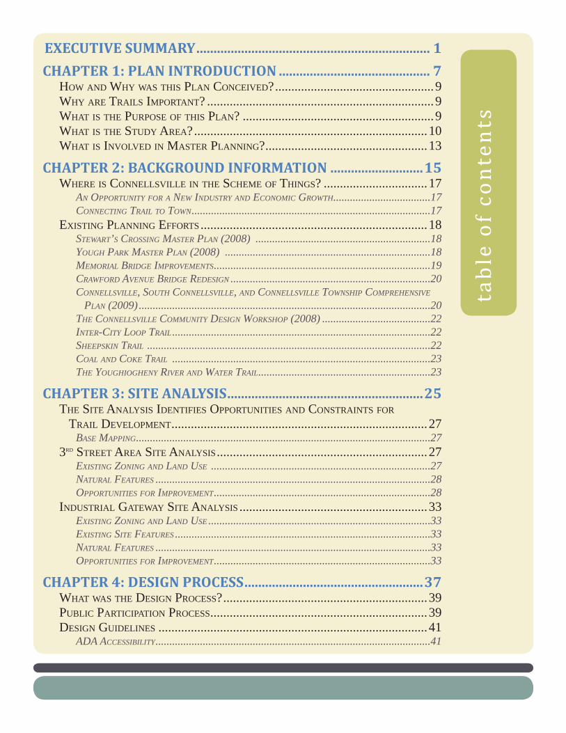
EXECUTIVE SUMMARY .................................................................... 1
CHAPTER 1: PLAN INTRODUCTION ............................................ 7 HOW AND WHY WAS THIS PLAN CONCEIVED? .................................................9WHY ARE TRAILS IMPORTANT? ......................................................................9WHAT IS THE PURPOSE OF THIS PLAN? ...........................................................9WHAT IS THE STUDY AREA? ........................................................................10WHAT IS INVOLVED IN MASTER PLANNING? ..................................................13
CHAPTER 2: BACKGROUND INFORMATION ...........................15WHERE IS CONNELLSVILLE IN THE SCHEME OF THINGS? ................................17
AN OPPORTUNITY FOR A NEW INDUSTRY AND ECONOMIC GROWTH ...................................17CONNECTING TRAIL TO TOWN ......................................................................................17
EXISTING PLANNING EFFORTS ......................................................................18STEWART’S CROSSING MASTER PLAN (2008) ...............................................................18YOUGH PARK MASTER PLAN (2008) ..........................................................................18MEMORIAL BRIDGE IMPROVEMENTS ..............................................................................19CRAWFORD AVENUE BRIDGE REDESIGN ........................................................................20CONNELLSVILLE, SOUTH CONNELLSVILLE, AND CONNELLSVILLE TOWNSHIP COMPREHENSIVE PLAN (2009) .........................................................................................................20THE CONNELLSVILLE COMMUNITY DESIGN WORKSHOP (2008) .......................................22INTER-CITY LOOP TRAIL .............................................................................................22SHEEPSKIN TRAIL ......................................................................................................22COAL AND COKE TRAIL .............................................................................................23THE YOUGHIOGHENY RIVER AND WATER TRAIL ..............................................................23
CHAPTER 3: SITE ANALYSIS .........................................................25THE SITE ANALYSIS IDENTIFIES OPPORTUNITIES AND CONSTRAINTS FOR TRAIL DEVELOPMENT ...............................................................................27
BASE MAPPING ..........................................................................................................273RD STREET AREA SITE ANALYSIS .................................................................27
EXISTING ZONING AND LAND USE ...............................................................................27NATURAL FEATURES ...................................................................................................28OPPORTUNITIES FOR IMPROVEMENT ..............................................................................28
INDUSTRIAL GATEWAY SITE ANALYSIS ..........................................................33EXISTING ZONING AND LAND USE ................................................................................33EXISTING SITE FEATURES ............................................................................................33NATURAL FEATURES ...................................................................................................33OPPORTUNITIES FOR IMPROVEMENT ..............................................................................33
CHAPTER 4: DESIGN PROCESS ....................................................37WHAT WAS THE DESIGN PROCESS? ...............................................................39PUBLIC PARTICIPATION PROCESS ...................................................................39DESIGN GUIDELINES ...................................................................................41
ADA ACCESSIBILITY ...................................................................................................41
table of con
tents

PARK SUSTAINABILITY GUIDELINES...............................................................................41GREEN PRINCIPLES FOR PARK DEVELOPMENT AND SUSTAINABILITY ..................................43
DESCRIPTION OF CONCEPT/DRAFT PLANS .....................................................43FIRST AND THIRD ENLARGEMENT CONCEPTS .................................................................43INDUSTRIAL GATEWAY CONCEPT DRAFT ........................................................................47
CHAPTER 5: RECOMMENDATIONS ............................................49PROJECT GOALS .........................................................................................51
ECONOMIC OPPORTUNITIES .........................................................................................51TRAIL IMPROVEMENTS .................................................................................................51
RECOMMENDATIONS ....................................................................................52OVERALL CONNELLSVILLE PLAN ...................................................................................52STEWART’S CROSSING MASTER PLAN ............................................................................57YOUGH PARK MASTER PLAN .......................................................................................61THIRD STREET AREA MASTER PLAN ..............................................................................65
1. TORRANCE AVENUE BIKEWAY ..........................................................................692. RIVERSIDE REDEVELOPMENT ............................................................................753. NORTH FIRST AND THIRD STREETS PLANTING ..................................................784. VILLAGE GREEN .............................................................................................835. THIRD STREET STREETSCAPE IMPROVEMENTS ....................................................876. THIRD STREET RESIDENTIAL INFILL ..................................................................887. HISTORIC RESTORATION AREA .........................................................................898. MEASON STREET RESIDENTIAL REDEVELOPMENT ..............................................909. CRAWFORD AVE STREETSCAPE IMPROVEMENTS .................................................9110. THIRD AND CRAWFORD REDEVELOPMENT AREA ..............................................9311. FIRST AND CRAWFORD REDEVELOPMENT AREA ...............................................9912. HILLSIDE SCREENING ..................................................................................10313. SOUTH FIRST AND THIRD GREENING AND OVERLOOK ....................................10414. FACADE IMPROVEMENT AREA ......................................................................111
INDUSTRIAL GATEWAY MASTER PLAN ..........................................................................11315. BICYCLE RAILING ALONG STEEP SLOPES .......................................................11716. VEGETATIVE SCREEN ...................................................................................11917. MURAL PROJECTS .......................................................................................12018. INDUSTRIAL PORTAL AND OVERLOOK............................................................121
OPINION OF PROBABLE CONSTRUCTION COSTS ............................................125PHASING PLAN .........................................................................................126
APPENDICES .................................................................................. 127Funding Sources• Potential Residential Riverfront Redevelopment• Ballfi eld Options• Shared Use Lane Information• Market Background• Permeable Paving Information•

execut ive summary
1


The Trail Town Program, an initiative of The Progress Fund and the City of Connellsville, have long recognized the economic benefi ts of the Great Allegheny Passage (GAP) for Connellsville. The GAP is a 150-mile biking and hiking path connecting Pittsburgh to Cumberland, MD and on to Washington DC through the 185 mile long C & O Canal Towpath. As a Trail Town, the City of Connellsville seeks to better connect “trail and town.”
The purpose of this Plan is to identify trail improvements and economic development opportunities that will enhance the trail experience, improve the local economy, and increase the quality of life for Connellsville residents and trails users.
Several broad recommendations include:
Strengthen Crawford Ave as a “Main Street.”• This is done by concentrating commercial / mixed use redevelopment and façade improvements within a couple of blocks of the bike lanes on 3rd Street.
Strengthen the Residential Area North of Crawford Ave. • This is accomplished with residential redevelopment and infi ll, historic restoration, and new park development.
Create Bicycle Gateways. • A gateway at both trail entrances into Connellsville not only identifi es the City boundary, but starts to describe the character and creates anticipation to a destination.
Create Vehicular Gateways.• This includes vehicular oriented gateways at the intersections of Route 119 / Pittsburgh Street and Route 119 / Crawford Street to welcome visitors and direct people towards downtown and trail access.
Improve the Streetscape.• Major streetscape improvements along Crawford Ave focus on creating a pedestrian and bicycle oriented environment.
Create Bicycle Plazas. • Creating spaces for bicyclists to stop, park their bikes, rest, and get information about local businesses further facilities trail-related tourism and economic opportunities.
Employ Environmentally Sustainable Design and • Construction Solutions. Using sustainable practices not only protects the environment but also improves the quality of life.
Provide Bike Loops Connecting Commercial • Activities.
executive s
ummary
3


W Crawford AveW Crawford Ave
Marietta AveMarietta Ave
Meason StreetMeason Street
E Crawford AveE Crawford Ave
E Fairview AveE Fairview Ave
E Apple StreetE Apple Street
E Peach StreetE Peach Street
N 1st Street
N 1st Street
N W
ater StreetN
Water Street
N A
rch Street
N A
rch Street
S Arch
StreetS A
rch Street
N Pittsb
urg
h Street
N Pittsb
urg
h Street
N Pro
spect Street
N Pro
spect Street
S Prosp
ect StreetS Pro
spect Street
S Pittsbu
rgh
StreetS Pittsb
urg
h Street
N M
eadow
Lane
N M
eadow
Lane
Hig
hlan
d A
veH
igh
land
Ave
N Arch Street
N Arch Street
York A
veYo
rk Ave
Fayette Street
Fayette Street
S 1s
t Stre
et
S 1s
t Stre
etN
2nd
StreetN
2nd
StreetS 2n
d Street
S 2nd
Street
N 3rd
StreetN
3rd Street
S` 3rd Street
S` 3rd Street
N 4th
StreetN
4th Street
S 4th Street
S 4th Street
N 5th
StreetN
5th Street
Memorial B
lvd
Memorial B
lvd
N 6th
StreetN
6th Street
S 6th Street
S 6th Street
N 7th
StreetN
7th Street
S 7th Street
S 7th Street
N 8th
StreetN
8th Street
S 8th Street
S 8th Street
N 9th
StreetN
9th Street
S 9th Street
S 9th Street
Youghiogheny Parkby Mackin
Youghiogheny Parkby Mackin
Youg
hiog
heny
Riv
er
Youg
hiog
heny
Riv
er
Gateway to Gateway
Master Plan
Gateway to Gateway
Master Plan
Current Bridge Redesign
by Mackin
Current Bridge Redesign
by Mackin
Current Bridge Projectby PennDOT
Current Bridge Projectby PennDOT
Downtown Master PlanDowntown
Master Plan
Stewart’s Crossing
by Widmer and David Reagan
Stewart’s Crossing
by Widmer and David Reagan
"ò
£¤119£¤119
£¤119
"è
OVERALL CONNELLSVILLE PLANOVERALL CONNELLSVILLE PLAN
CONNELLSVILLE GATEWAY TO GATEWAY MASTER PLAN
INCOPRPORATED
LEGEND
Facade Improvement Area
Commercial / Mixed Use RedevelopmentHistoric Restoration
Residential Infill
Park Land
Vehicular Gateway
Bicycle Gateway
Streetscape Improvements
Great Allegheny Passage
Inter-City Loop TrailCoal & Coke Trail Connector
Bicycle Plaza
Existing Boat Launch
Boat Docks


chapter 1:plan introduct ion
7


9
HOW AND WHY WAS THIS PLAN CONCEIVED?The Trail Town Program, an initiative of The Progress Fund and the City of Connellsville, have long recognized the economic benefi ts of the Great Allegheny Passage (GAP) for Connellsville. The GAP is a 150-mile biking and hiking path connecting Pittsburgh to Cumberland, MD and on to
Washington DC through the 185 mile long C & O Canal Towpath. The GAP runs through the City crossing Crawford Ave, the “Main Street” of Connellsville.
As a Trail Town, the City seeks to better connect “trail and town.” By defi nition, Trail Towns are small town centers of commerce for bikers, visitors, and residents. Just as other Trail Towns have benefi ted from the GAP, both economically and recreationally, Connellsville would like to take full advantage of the new and growing trail-related tourism industry. As a result, Pashek Associates was hired to lead the development of the Connellsville Gateway to Gateway Master Plan.
WHY ARE TRAILS IMPORTANT?The trails of the Connellsville area have the potential to become the defi ning feature of the community for years to come. The convergence of multiple trails, both land and water based, can have a signifi cant impact on the Connellsville community.
Trails provide a multitude of recreational opportunities for people of all ages and abilities. They attract users because of the vast array of opportunities that come with them…..the opportunity to walk, run, bike, blade or paddle; to enjoy the scenery, to exercise, to see the wildlife, be active, to be alone, to be with friends…the list goes on and on. It is because of this vast potential that trail users have rapidly become one of the largest recreational user groups nationwide. They come from the local community, from other places close-by, and from greater distances away, an economic opportunity for Connellsville.
WHAT IS THE PURPOSE OF THIS PLAN?The purpose of this Plan is to identify trail improvements and economic development opportunities that will enhance the trail experience, improve the local economy, and increase the quality of life for Connellsville residents and trails users.
chap
ter
1:pl
an i
ntro
duct
ion
10
All recommendations proposed by the Gateway to Gateway Plan seek to:
Protect the Natural Environmentapply sustainable stormwater Best Management Practices• increase plantings to convert CO2 to Oxygen and reduce the heat • island effectpreserve habitat and wildlife•
Provide Community Benefi tssuch as places for community events and social gatherings• offer opportunities for physical exercise• establish places to safely enjoy the natural and built environment•
Provide Economic Benefi tsattract businesses and their employees to the area• increase property values• increase tourism•
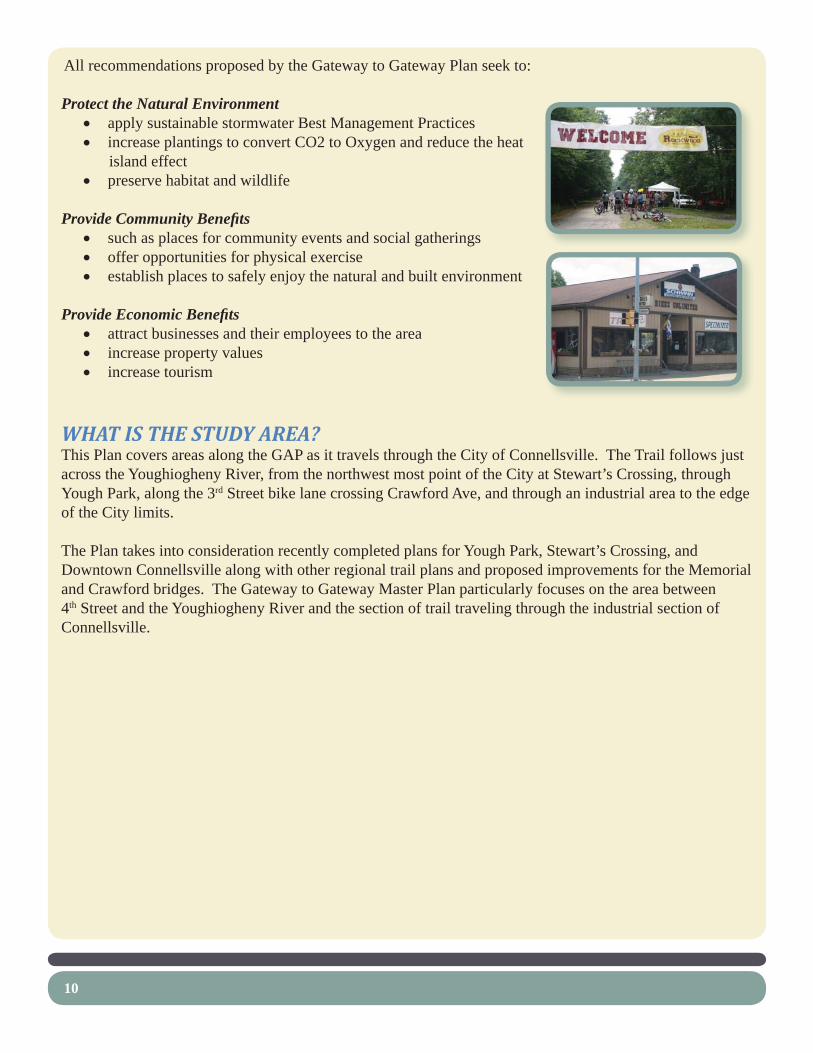
WHAT IS THE STUDY AREA?This Plan covers areas along the GAP as it travels through the City of Connellsville. The Trail follows just across the Youghiogheny River, from the northwest most point of the City at Stewart’s Crossing, through Yough Park, along the 3rd Street bike lane crossing Crawford Ave, and through an industrial area to the edge of the City limits.
The Plan takes into consideration recently completed plans for Yough Park, Stewart’s Crossing, and Downtown Connellsville along with other regional trail plans and proposed improvements for the Memorial and Crawford bridges. The Gateway to Gateway Master Plan particularly focuses on the area between 4th Street and the Youghiogheny River and the section of trail traveling through the industrial section of Connellsville.


13
WHAT IS INVOLVED IN MASTER PLANNING?This Master Plan process involves a number of steps, including the following:
Chapter 2 - Background Information• Describe how this Study fi ts in with the City of Connellsville.o Review existing planning efforts related to this Study.o
Chapter 3 - Site Inventory and Analysis • Analyze existing natural and cultural conditions within the study focus area in order to o identify opportunities for improvements.
Chapter 4 - Public Design Process• Gather input through public participation (i.e. public input sessions, study committee o meetings, key person interviews) that encourages collaboration with interested citizens to identify future recreation and economic development policies.Present Concept Plans.o
Chapter 5 - Recommendations and Implementation• Identify potential economic development opportunities along with potential relocation sites o for incompatible businesses located within the study area.Prepare an overall Master Plan along with selected enlargement Plans identifying specifi c o projects and associated recommendations.Estimate construction costs for both the economic development opportunities and proposed o trail improvement projects.Preparation of a phased capital improvements plan identifying strategies for development.o
Appendices• Funding Sourceso Potential Residential Riverfront Redevelopmento Ballfi eld Optionso Shared Use Lane Informationo Market Backgroundo Permeable Paving Informationo
It is essential to note that the Master Plans are meant to be a fl exible tool for planning. Specifi c details of the design and the fi nal locations of facilities may be adjusted through subsequent design.


chapter 2:background information
15


17
WHERE IS CONNELLSVILLE IN THE SCHEME OF THINGS?The City of Connellsville is located in Fayette County, Pennsylvania at the foothills of the Laurel Highlands. The Youghiogheny River fl ows through the City and the Great Allegheny Passage (GAP) connects the City to the heart of Ohiopyle State Park just 17 miles away.
AN OPPORTUNITY FOR A NEW INDUSTRY AND ECONOMIC GROWTHNo longer a great capital of industry producing coal and coke, the City is now searching for a new source of economic growth and job creation. The GAP has created a new hope for Connellsville’s economic recovery by bringing in trail-related tourism. The GAP has generated millions of dollars in trail-related revenue and new jobs for its Trail Towns. Connellsville is looking to capitalize on this opportunity.
The GAP has become an attraction for many from outside the area. The trail is designed as a non-motorized, shared-use, recreational trail for bicycling, walking, fi shing and canoe access, hiking, nature study, historic appreciation, cross country skiing, picnicking, and “in-part” horseback riding. Now, with the recent connection of the Sheepskin Trail, that will eventually connect to other regional trails; with the proposed Coal and Coke Trail connection, the development of an Inter-City Loop Trail, and the designation of the Yough River Water Trail, there is great attraction for visitors and trail users from around the region and beyond.
CONNECTING TRAIL TO TOWNFortunately, the GAP already crosses the west side of Crawford Avenue, Connellsville’s “Main Street.” There are two distinct development characteristics along Crawford Ave, separated by the Youghiogheny River. The east side consists of the original historic downtown area with taller buildings hosting banks, offi ces, some retail, and restaurants. The west side consists of a more recent development pattern with two story buildings housing more retail-oriented businesses. Making improvements to both sides of Crawford Ave will help make Connellsville a successful Trail Town.
chap
ter
2:ba
ckgr
ound
inf
orm
atio
n

18
EXISTING PLANNING EFFORTSCurrently, there are several planning and construction projects underway or recently completed within the City of Connellsville. Several that directly relate to the GAP include:
STEWART’S CROSSING MASTER PLAN (2008) This master plan, developed by Widmer Engineering and David Reagan, creates an exciting plan for park development on the northern bicycle gateway of the GAP into the City. Recommendations include improved trail head parking, trail realignment, overlook, amphitheater, restrooms, and historical interpretation relating to Stewart’s Crossing. Recently, a kiosk describing Connellsville and its history along with a sculpture serving as a physical gateway have been built in this location. The next phase will be improvements to the parking lot near the gateway.
YOUGH PARK MASTER PLAN (2008) Next, the GAP passes through Yough Park in which Mackin Engineering has recently completed a master plan. Currently, Yough Park offers a variety of amenities for trail users including parking, picnic shelters, a playground, river access, visitor information, an ice cream shop, recreational facilities, historic sites, and restrooms. The park also includes an area operated by the Connellsville Historical Society that includes the Colonel Crawford Cabin, a spring house, picnic shelter, and open lawn area.
This park will serve as the hub of the regions trails. The fi rst phase of construction began in the summer of 2009 and includes a kiosk plaza with tables and umbrellas, chairs, geranium garden area, fl owering trees, decorative lighting and landscaping; relocation of a chain-link fencing at the municipal authority’s sewage pumping station; removal of the boardwalk and lawn restoration after demolition.

19
MEMORIAL BRIDGE IMPROVEMENTSRecently redesigned by PennDOT to better accommodate pedestrians and bicyclists, this bridge serves as a key connection for the Coal and Coke Trail extension and the Inter-City Loop Trail.

20
CRAWFORD AVENUE BRIDGE REDESIGNMackin Engineering has recently looked into pedestrian and bicycle improvements for this bridge. The bridge serves as a major connection between the GAP and downtown Connellsville. The report concluded that the existing bridge structure will support new cantilevered brackets for a widened 8 or 10 foot sidewalk on one or both sides of the bridge.
CONNELLSVILLE, SOUTH CONNELLSVILLE, AND CONNELLSVILLE TOWNSHIP COMPREHENSIVE PLAN (2009)This Plan, completed by Mullin and Lonergan and Pashek Associates, has recently looked into revitalizing the area, particularly downtown Connellsville. The plan recognizes that bicyclists and other tourists need places to eat, sleep, and shop. In addition, they need appropriately located bike racks to temporarily and safely store their bikes while they explore the area’s amenities. The urban, city experience that downtown Connellsville offers bicyclists and other tourists could be enhanced with the addition of restaurants, hotels, shops, circulation improvements, and better signage to direct trail users to area amenities, including “share the road” signage.
In order to take advantage of the tourism generated by the GAP and to create a dense central core, the Comprehensive Plan calls for concentrating reinvestment activities within an area defi ned by Prospect Street, Fairview Avenue, Water Street, and Apple Street. In particular, major reinvestment activities are located along Pittsburgh Street, Crawford Ave, and North Meadow Lane within this defi ned area.
A Downtown Master Plan was created as part of the Comprehensive Plan. Proposed improvements include:
Commercial / Mixed Use Redevelopment• – Identifi es properties in which commercial infi ll, reinvestment, and redevelopment will contribute to the density and vitality of downtown. The

21
Plan identifi es a hotel redevelopment site and the Mongell property across the River as key redevelopment properties for the downtown area. Historic Restoration• – Identifi es historically signifi cant buildings such as the Brimstone and Aaron buildings along with buildings in key locations within downtown.Bicycle Facilities Improvements• – Identifi es opportunities in which improved bicycle facilities will allow bicyclists traveling along the GAP to conveniently access downtown and its amenities, including an Inter-City Loop Trail and bike plaza for lockers, bike racks, kiosk, and seating.Streetscape Improvements• – Identifi es Pittsburgh Street, Crawford Avenue, and North Meadow Lane as streets in which public right-of-way improvements will contribute to the overall character, and function of downtown. Streetscape improvements include street trees, new sidewalks, brick crosswalks, light posts, bump outs at intersections, and screened parking lots.

22
THE CONNELLSVILLE COMMUNITY DESIGN WORKSHOP (2008)The Pennsylvania Environmental Council and Studio Three facilitated this three day workshop designed to motivate and gather ideas from the community. Four primary concepts were developed:
Visitors to Connellsville who utilize the Great Allegheny Passage create demand for lodging and • other retail opportunities along Crawford Avenue and Downtown Connellsville; A community catering to outdoor recreation, particularly bicycling, should have activities and areas • that are pedestrian in scale and accessibility;Connellsville should be viewed as a • gateway to the Laurel Highlands and as a hub for recreation and tourist activities and tourism support;While tourism and the Great Allegheny Passage are tremendous catalysts for Connellsville, the • revitalization efforts must fi rst meet the needs of the local residents and businesses.
Recommendations included façade and streetscape improvements, new public spaces, in addition to pedestrian and bicycle improvements to the Crawford Avenue Bridge.
INTER-CITY LOOP TRAILTo further enhance the Great Allegheny Passage, the City is in the process of planning a 1.5 mile inter-city loop trail that will connect local residents and downtown business people to the park and trails, and will also provide access for trail users to a host of City attractions.
SHEEPSKIN TRAIL The Sheepskin is a rail-trail project that cuts through the heart of central Fayette County. Still in the early stages of development, it is a missing link to a nationally signifi cant trail system. To the north, it will link

23
with the Pittsburgh-to-Washington DC Rail-Trail Network and the American Discovery Trail. To the south, it will link with the West Virginia Rail-Trail System, and the American Discovery Trail. As a recreational greenway, the Sheepskin will link the Youghiogheny, Monongahela, and Cheat River watersheds—making it a signifi cant greenway.
The Sheepskin is entirely in Fayette County, Pennsylvania, and will run approximately 33 miles from Dunbar Township (at the GAP) to Point Marion Borough (at the Mon River Trail connection).
The initial 2.2 miles of the Sheepskin Trail, located in Dunbar Township, opened on Memorial Day 2008 as a spur trail off of the GAP.
COAL AND COKE TRAIL The Coal & Coke Trail is a 5 1/2 mile-long trail linking the Westmoreland County communities of Mount Pleasant and Scottdale. The Trail provides outdoor recreational opportunities for walkers, joggers, bikers, hikers, and cross-country skiers.
There are future plans to also provide a link to the West Overton Museum. The City of Connellsville proposes a connection of the Coke and Coal Trail with the GAP and its planned Inter-City Trail within the City limits.
THE YOUGHIOGHENY RIVER AND WATER TRAILThe Pennsylvania Environmental Council is in the process of developing an offi cial water trail along the Youghiogheny River. The Yough River, by itself, is an exceptional recreational attraction for the Connellsville area. In combination with other local facilities, it becomes a hub of recreation for the entire region. It provides a wide variety of recreational opportunities. The most apparent are fi shing, boating, canoeing, and kayaking. Additionally, many simply enjoy walking, sitting, picnicking, or relaxing along the river’s edge.
As a Trail Town, the addition of a water trail will provide added recreational and economic opportunities for the Connellsville area. A water trail map will be published by the PA Fish and Boat Commission early in 2009.


chapter 3:site analysis
25


27
THE SITE ANALYSIS IDENTIFIES OPPORTUNITIES AND CONSTRAINTS FOR TRAIL DEVELOPMENTThe next step in the Master Plan process is to analyze existing natural and cultural conditions within the study focus area in order to identify constraints and opportunities for improvements. Since other planning efforts have already covered Stewart’s Crossing and Yough Park, the Site Analysis for this Plan covers two areas along the GAP in Connellsville; the 3rd Street Area and the Industrial Gateway on the southern border of Connellsville Borough.
BASE MAPPINGA base map of existing conditions was prepared from aerial photography and GIS information. This mapping was supplemented with fi eld observations conducted in 2009 by Pashek Associates.
3RD STREET AREA SITE ANALYSIS
EXISTING ZONING AND LAND USE
The GAP travels through four types of land use areas within Connellsville. When entering the City from the north, one travels the GAP through two parks, Stewart’s Crossing and Yough Park. As mentioned in the previous chapter, there are plans to improve these green spaces for both City residents and trail users.
Next, the trail turns into a bike lane on 3rd Street as it intersects with 1st Street. Views of the overfl ow park lot, residential neighborhood, and the Laurel Highlands can be seen at this intersection. This area includes mostly single-family homes with a few commercial businesses mixed in. Some of these businesses are incompatible with residential land use. There is also potential for infi ll housing within this area.
The GAP comes at a major crossroads at Crawford Ave, the west side “Main Street” area of the City. Crawford Ave hosts several retail establishments including some bike-related businesses. An existing stop light allows for safe crossing, including a push button for trail users. It is at this point, trail users can make a decision as to whether they would like to stop in Connellsville to explore and spend money. Here, the proposed Inter-City Loop Trail turns onto Crawford towards downtown. Further down Crawford is another important intersection at 1st Street. Here, views of downtown can be seen, potentially enticing trail users to venture further into the historic business district.
chap
ter
3:si
te a
naly
sis

28
Finally, the trail travels through a more industrial section of the City. Here, a few institutional and commercial properties transition into the industrial heritage of the City. The bike lanes turn back into a trail along the River.
In essence, the trail user is able to see several different qualities of Connellsville. Enhancing each of those areas will entice the trail user to stop in Connellsville.
NATURAL FEATURESAs in most urban areas, natural features are limited. The following are natural features that may affect opportunities for development within the study area.
The soils for this area are exclusively Monongahela silt loam with zero to two percent slopes (MoA). The parent material is old alluvium derived from sandstone and shale and are moderately well drained. Even though well developed, most of this area from Crawford Ave north is within the fl oodplain. Therefore, any proposed buildings north of Crawford Ave should require provisions for fl ood proofi ng.
Steep slopes exist along the Youghiogheny River limiting building development. The GAP itself has very little grade change making it accessible to anyone.
A riparian buffer exists along several areas of the Youghiogheny River. Riparian buffers are areas of vegetation along waterways that protect water quality and stabilize stream channels. Vegetated areas along streams and rivers are of signifi cant ecological importance as they:
Slow and reduce fl ood waters through infi ltration and root absorption• Improve water quality by fi ltering stormwater runoff• Recharge groundwater• Provide canopy cover that shades and cools streams, thus improving habitat conditions for in-stream • organismsProvide habitat for a variety of birds and small mammals, including access to shelter, food, and • water
The riparian buffer along the Youghiogheny River should be protected by limiting major development within the buffer area.
OPPORTUNITIES FOR IMPROVEMENTSeveral planting opportunities include:•
The intersection of 1o st and 3rd Streets by Yough Park on City owned land. Cleaning up this area would create a better welcome for trail users coming in from the north.
29
The southeast corner of Crawford Ave and 1o st Street. An excessive amount of pavement exists in this area near the bridge.The small hillside near the southern end of the 3o rd Street bike lanes. Plantings would soften large industrial buildings. In addition, excessive amounts of pavement surround the daycare center.
An overlook opportunity exists at the southern end of 3• rd and 1st Streets.
Streetscape improvements along Crawford Ave would create a more pedestrian and bicycle-oriented • environment.
Redevelopment and infi ll opportunities exist within the residential area and along Crawford Ave.•
Strengthening key intersections including 1• st and 3rd by Yough Park, 3rd and Crawford, and 1st and Crawford.
Strengthening each of the four general land use areas.•


W Crawford AveW Crawford Ave
Meason StreetMeason Street
N 1st Street
N 1st Street
S 1s
t Stre
et
S 1s
t Stre
et
N 2n
d Street
N 2n
d Street
S 2nd
StreetS 2n
d Street
N 3rd
StreetN
3rd Street
S` 3rd Street
S` 3rd Street
N 4th
StreetN
4th Street
S 4th Street
S 4th Street
Youg
hiog
heny
Riv
er
Youg
hiog
heny
Riv
er
3RD STREET AREA - SITE ANALYSIS3RD STREET AREA - SITE ANALYSIS
CONNELLSVILLE GATEWAY TO GATEWAY MASTER PLAN
INCOPRPORATED
LEGENDPotential Infill / Redevelopment
Incompatible Use
Potential Park / Green Space
Key Trail Intersection / Node
Planting Opportunity
Great Allegheny Passage
Bicycle Loop Trail“Main Street” Commercial Area
Residential Area
Institutional / Industrial / Commercial Area
Park Area
Major Downtown Connection


33
INDUSTRIAL GATEWAY SITE ANALYSIS
EXISTING ZONING AND LAND USEThe entire area along the GAP from the southern intersection of 1st and 3rd Streets to the southern City border is zoned industrial. Here, the GAP passes by a large industrial area on one side and the River on the other before heading out of the City and into forested land.
EXISTING SITE FEATURESChain link fencing separates the trail from Allegheny • Power, the largest property holder in this area. Split rail fencing separates the trail from an access road leading to the Youghiogheny Glass Factory. • Six foot high chain link fencing acts as a safety barrier between trail and steep slopes down to the • River. Chain link gate allows for trail maintenance access.• A mural on the silos at the Youghiogheny Glass Factory incorporates factory glass pieces.•
NATURAL FEATURESThe natural features in this area are similar to those in the 1st and 3rd Street Area. Wetland type plants were observed at the southern City boundary.
OPPORTUNITIES FOR IMPROVEMENTSpace for planting a small screen exists along the • chain link fence near the Glass Factory.
Improving site distances and views for bicyclists • where the trail narrows and turns. The existing six foot tall chain link fence obstructs views.
Several blank walls, whether on buildings or retaining • walls, presents opportunities for murals.
Interpreting the current and historical legacy of • industry in Connellsville.
Space for creating a portal-like gateway entering the • City from the south exists.


Green StreetGreen Street
Beech Street
Beech Street
Leisenring AveLeisenring Ave
Graham AveGraham Ave
S` 7th Street
S` 7th Street
S 8th Street
S 8th Street
Youg
hiog
heny
Riv
er
Youg
hiog
heny
Riv
er
Allegheny Power
Allegheny Power
Glass Industry
Glass Industry
Allegheny Power
Allegheny Power
INDUSTRIAL GATEWAY - SITE ANALYSISINDUSTRIAL GATEWAY - SITE ANALYSIS
CONNELLSVILLE GATEWAY TO GATEWAY MASTER PLAN
INCOPRPORATED
LEGEND
Industrial Area
Park Area
Narrow Point in Trail
Chain Link Fence
Planting Opportunity
Existing Wetland
Great Allegheny Passage
Existing Trail Maintenance Access
Mural Opportunity
Existing Bench
Existing Murals on Silos


chapter 4:design process
37


39
WHAT WAS THE DESIGN PROCESS?This chapter describes how the master plan was developed. Together with the inventory and analysis, public participation played a key role in helping the consultant develop the fi nal master plan. Local community members and offi cials revealed more specifi c information about the site to the consultant and helped guide the development of several Concept Plans. The Concept Plans were revised according to feedback given by the public. Design Guidelines were also developed to guide requirements. Finally, the draft version was refi ned into the Final Master Plan, which is described in the Recommendations and Implementation Chapter.
PUBLIC PARTICIPATION PROCESSPublic participation in the design process is important in ensuring that the fi nal master plan refl ects community needs and is fully supported by local decision makers and members of the community. The public participation process for this study included:
Yough Park Master Planning Coordination • - The Yough Park Master Plan was developed concurrently with this project by Mackin Engineering. We have included the fi nal master plan, and have included their phasing and cost estimates where appropriate in our phasing of the projects for this master plan. We met three times on-site to review the master planning efforts.Stewart’s Crossing Master Plan Coordination• - We communicated at meetings and through the exchange of planning information with Widmer Engineering, the principal planning fi rm for this master plan. Their cost estimates and phasing were also incorporated into this plan. The Widmer representative attended three meetings where we were able to coordinate planning efforts.Steering Committee Meetings• - We met with our task force and other stakeholders at meetings on May 21, July 8, and November 3, 2009 to review various stages of the master planning process and to receive feedback. Steering Committee members included representatives of trail groups, City Council, City Redevelopment Authority, PEC, and the Trail Town program of the Progress Fund.Public Meeting• - A copy of the draft master plan was presented to the public and before Council at their regularly scheduled meeting on October 15, 2009.Main Street Coordination Meetings • - Several meetings were held in Connellsville regarding the redevelopment of property in the area bound by the Yough River, Crawford Avenue, and Third Street. Mullin and Lonergan representatives worked closely with this master planning team to develop a coordinated effort on recommendations for the master plan. There were three specifi c meetings to address redevelopment issues between Pashek Associates and Mullin and Lonergan, although additional discussions occurred at other meetings as well.Gateway Meetings• - two meetings were held in early 2009 to specifi cally address the gateway development proposed at both ends of the project. The ultimate designs refl ect the integration of industrial heritage and environmental stories that will be told at the gateways.Other Meetings• - There were a number of other meetings held throughout the planning process, all held on-site or in Connellsville, to discuss important issues offered by stakeholders. A meeting on May 4, 2009 was held at the DCED offi ces in Pittsburgh to review the economic redevelopment strategies that were being developed at that time. A tour of the Gateway project was scheduled with Linda McKenna Boxx in order to coordinate their activities on the GAP trail with these efforts.
chap
ter
4:de
sign
pro
cess
40
We also made a presentation to both DCNR and DCED secretaries on-site regarding the various planning efforts taking place along the trail corridor.Comprehensive Plan Coordination• - The Multi-municipal Comprehensive Plan for the City of Connellsville, South Connellsville and Connellsville Township was prepared by Mullin and Lonergan concurrently with this plan. Pashek Associates was a subconsultant on that plan focusing on Parks, Recreation, Urban Design and Zoning. For this Gateway to Gateway project, Mullin and Lonergan were a subconsultant to Pashek Associates focusing on redevelopment opportunities in the Crawford Avenue and Third Street area of the City. As a result of working together on both projects, we were able to make sure that the overall goals and objectives developed for the Comprehensive Plan were integrated into the thinking for the Gateway to Gateway projects. Further, recommendations for the Gateway to Gateway project, especially those recommendations related to redevelopment, were integrated into the Comprehensive Plan. The public processes of both projects overlapped and benefi t each individual project. Key Person Interview Conclusions• - Throughout the planning process we interviewed a number of people about various aspects of the project. Early on, we toured the area on bikes with Linda McKenna Boxx to better understand the importance of the Great Allegheny Passage (GAP) to this project. She provided a helpful understanding, along with Cathy McCullough of the Trail Towns program of the economic impact of the GAP trail users and what trail amenities we might consider in the planning of the project. As a result of their input, we focused on way fi nding and development of portals and historic interpretive opportunities. We also integrated some of the creative art initiatives that were taking place in the City, along the trail.
As we started to develop strategies for redevelopment in the Third Avenue and Crawford corridor, we met with Michael Edwards, Connellsville Redevelopment Authority executive director and Glen Wolfe, PE, engineer for the Authority. They were helpful in identifying property owners that might be willing to discuss redevelopment plans and Glen suggested improvements to traffi c fl ow issues proposed in the new plans for Third Avenue.
We interviewed Glen Wolfe and Dexston Reed regarding the Stewart’s Crossing Master Plan and Bob Genter, RLA regarding the Yough Park Master Plan. Based on these discussions, we were able to develop a common strategy to improve the transition of the trail experience from Yough Park, along Torrance Avenue and past a proposed gateway at the corner of North First Street and Third Street.
We met with Mayor Judy Reed on several occasions to better understand the history of the Third Street bikeway development and opportunities and constraints to various options we discussed. In addition, we talked to City staff and the County about relevant zoning for the area and the Corps of Engineers about the fl oodway along the Yough River.
The public input process culminated in the identifi cation of proposed improvements and development opportunities, as well as their relationships to each other, which the Master Plan refl ects. The public meetings were advertised in local newspapers, as required by law, to ensure that interested residents would have a forum to voice their opinions.

41
DESIGN GUIDELINESRecommendations for the Gateway to Gateway Master Plan abide by the following design guidelines to ensure quality development that is safe, accessible, and sustainable.
ADA ACCESSIBILITYEnsuring accessibility not only accommodates those with disabilities, but also makes it easier for the general public to use the facilities. It is imperative that the City take steps to provide accessibility for all.
Accessibility, in design terms, is described by the Americans with Disabilities Act (ADA), which guarantees equal opportunity for individuals with disabilities to participate in the mainstream of public life. To do so, the ADA sets requirements for facilities to prevent physical barriers that keep people with disabilities from participating. When recreational facilities are built or altered, they must comply with the ADA standards by providing an accessible route to the area of use.
Most of the project area is fairly level and ramps can be avoided unless there is a grade change into a building. However, for project funding by DCNR, handicap accessibility specifi cally manifests itself in the provision for handicap parking stalls that are properly located and designated in the re-stripped Yough Park parking lot just north of Torrance Avenue and the proposed angled public parking on Third Street next to the Village Green. It is important to provide suffi cient numbers of parking for the handicapped.
Standards / Guidelines include:Americans with Disabilities Act (ADA), Title II Requirement for Public Facilities, • www.access-board.gov Architectural and Transportation Barriers Compliance Board’s “Regulatory Negotiation Committee • on Accessibility Guidelines for Outdoor Developed Areas”, September 1999, www.access-board.gov - sets minimum requirements for accessible trails, access routes, resting opportunities, benches, utility connections, and trash receptacles.American Association of State Highway Transportation Offi cials “Guide for the Development Of • Bicycle Facilities” Americans with Disabilities Act (ADA), Title II Requirement for Public Facilities, www.access-board.gov.
PARK SUSTAINABILITY GUIDELINESSome of the discussion during the public process turned toward providing more sustainable designs. “Creating Sustainable Community Parks, A Guide to Improving Quality of Life by Protecting Natural Resources”, published by the Pennsylvania Department of Conservation and Natural Resources (DCNR) in 2007, provides valuable recommendations regarding how to implement sustainable practices into design, maintenance, and operations of parks across the Commonwealth. The guide can be obtained from www.dcnr.state.pa.us/brc/GreeningPennsylvania.pdf
These practices are based on the following principals:
Retain as much of the pre-existing landscape as possible during new construction, including the soil, • rocks, native vegetation, wetlands, and contours. This will minimize disturbances, which can open up an area to invasive species. It can also keep costs down, as fewer new plants, soil amendments, and habitat enhancements will be needed.

42
Maintain high quality soils that will hold water and supply plants with proper nutrients. During • construction, leave as much existing topsoil as possible. When new soil is brought in, ensure that it is certifi ed weed free, in order to prevent the spread of new invasive species. Using compost and other natural products for mulch and fertilizer will help enhance the soil and feed the native plants. Good quality soil will reduce the need for fertilizers and supplemental watering.
Connect new landscape components with the surrounding native vegetation to create larger • contiguous areas of habitat. Many wildlife species need large ranges to fi nd adequate food, mates, and shelter. By reducing the amount of roads, parking lots, and turf areas, or by placing these together, habitat quality will be enhanced.
Create natural storm water management systems and other green infrastructure, such as rain gardens • and swales of native grasses. These systems help to minimize downstream fl ooding, recharge and fi lter groundwater, and are more cost-effective and environmentally-sound than man-made systems of pipes and storage tanks.
Protect wetlands from disturbance and fi ll. Avoid placing construction projects, day-use areas, and • roads/parking lots near or in wetlands. Natural wetlands provide many benefi ts to the environment that cannot easily be duplicated with man-made ones.
Use integrated pest management (IPM) strategies to minimize the use of chemical pesticides to • control plant and insect pests. IPM is an ecologically-based approach to pest control that helps maintain strong and healthy plants. IPM can include the use of traps, sterile male pests, and quarantines.
Minimize impermeable surfaces like roads, parking lots, and paved trails. Consider replacing asphalt • and concrete with permeable pavement, mulch paths, gravel lots, and native vegetation. Permeable surfaces help to recharge ground water, reduce erosion, lessen fl ooding events, and fi lter out pollutants. When impermeable surfaces must be used, arrange them in an area where they will not fragment habitat, make them as small in area as possible, and keep them away from water bodies.
Reduce turf to only those areas essential for recreational and other human use activities. Turf • offers little habitat benefi t and is not as effective as many native plants in pollution fi ltration, fl ood prevention, and erosion control. In addition, turf maintenance can have negative impacts on the surrounding environment and can require lots of mowing, watering, and fertilizing. Replace non-native turf grasses with native warm season grasses, which, once they are established, have lower maintenance needs.
Use native plants in riparian buffers around any surface water body, including wetlands. Riparian • buffers help to fi lter pollutants before they reach water bodies, and the vegetation discourages nuisance geese from staying in the area. Roots from riparian vegetation also prevent erosion of soils into the water body and minimize fl ooding events. Shade from these buffers acts as a temperature control for the water body, which enhances habitat value for aquatic organisms. The food and shelter values of these buffers also enhances habitat. In addition, by selecting the right kinds of plants, the scenic views of the water bodies can be enhanced.

43
Identify and remove invasive plant species whenever possible. Invasive plants have a number of • detrimental effects on natural habitats. Most invasive plants grow so densely and spread so rapidly that native vegetation is choked out.
Opportunities for sustainable design in Connellsville include permeable paving, rain gardens, native species, removing invasive species, reducing the amount of turf, expanding and restoring a riparian buffer, and promoting alternative transportation, to name a few.
GREEN PRINCIPLES FOR PARK DEVELOPMENT AND SUSTAINABILITYDCNR has recently developed a set of principles to help communities develop practical projects that conserve resources, generate economic and environmental benefi ts, and become healthier more sustainable places to live. More information can be found at http://www.dcnr.state.pa.us/brc/grants/indexgreen.aspx.
The following are the fi ve basic principles:
Principle #1: Maintain and Enhance Trees and Natural Landscaping• Principle #2: Connect People to Nature• Principle #3: Manage Stormwater Naturally• Principle #4: Conserve Energy• Principle #5: Integrate Green Design and Construction•
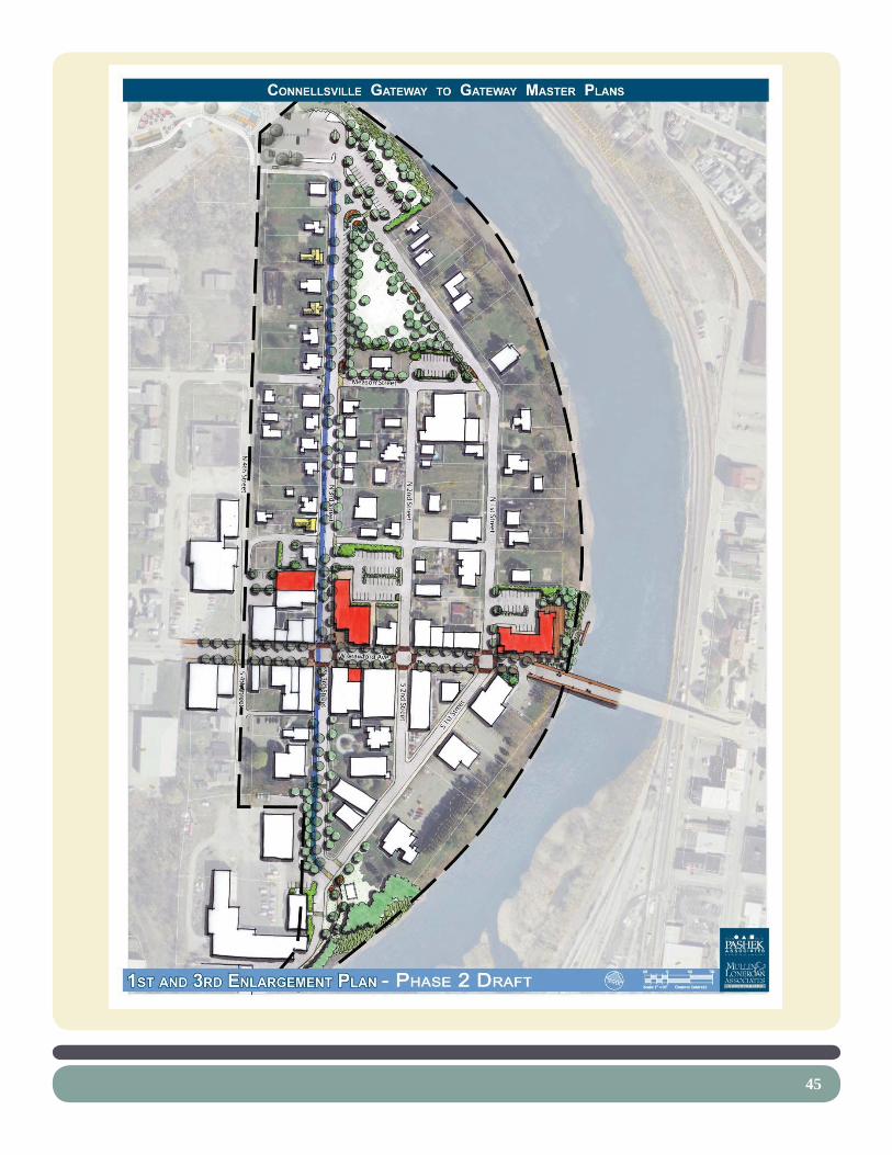
DESCRIPTION OF CONCEPT/DRAFT PLANSBased on the inventory and analysis and public input processes, several concept plans were developed for the Gateway to Gateway Master Plan. The conceptual plans refl ect the input received from City representatives, the project’s steering committee, and professional input from Pashek Associates staff members.
FIRST AND THIRD ENLARGEMENT CONCEPTSThese Draft plans were developed as options or potential phases and presented to the committee. They all include housing and mixed-use redevelopment and infi ll, streetscape improvements, and green space improvements related to the GAP.

44
45

46
47
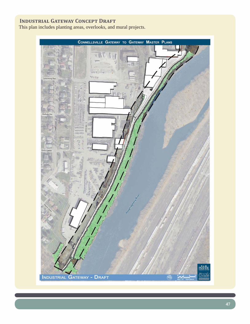
INDUSTRIAL GATEWAY CONCEPT DRAFTThis plan includes planting areas, overlooks, and mural projects.


chapter 5:recommendat ions
49

51
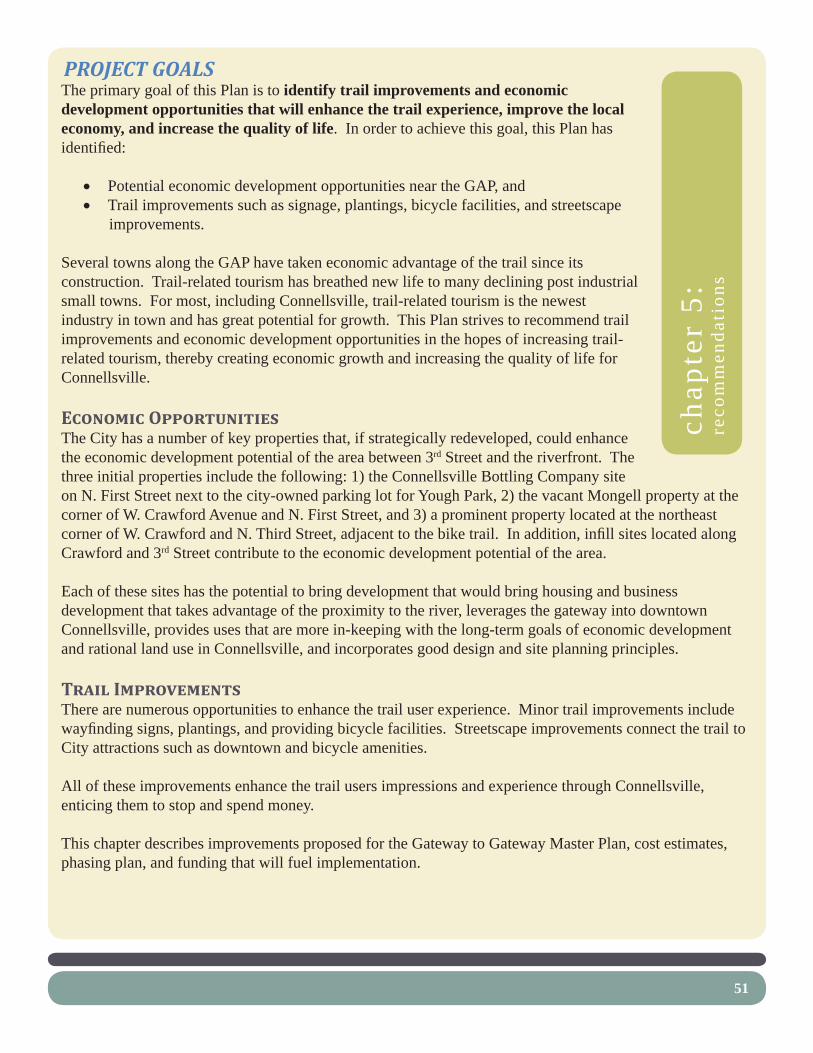
PROJECT GOALSThe primary goal of this Plan is to identify trail improvements and economic development opportunities that will enhance the trail experience, improve the local economy, and increase the quality of life. In order to achieve this goal, this Plan has identifi ed:
Potential economic development opportunities near the GAP, and• Trail improvements such as signage, plantings, bicycle facilities, and streetscape • improvements.
Several towns along the GAP have taken economic advantage of the trail since its construction. Trail-related tourism has breathed new life to many declining post industrial small towns. For most, including Connellsville, trail-related tourism is the newest industry in town and has great potential for growth. This Plan strives to recommend trail improvements and economic development opportunities in the hopes of increasing trail-related tourism, thereby creating economic growth and increasing the quality of life for Connellsville.
ECONOMIC OPPORTUNITIESThe City has a number of key properties that, if strategically redeveloped, could enhance the economic development potential of the area between 3rd Street and the riverfront. The three initial properties include the following: 1) the Connellsville Bottling Company site on N. First Street next to the city-owned parking lot for Yough Park, 2) the vacant Mongell property at the corner of W. Crawford Avenue and N. First Street, and 3) a prominent property located at the northeast corner of W. Crawford and N. Third Street, adjacent to the bike trail. In addition, infi ll sites located along Crawford and 3rd Street contribute to the economic development potential of the area.
Each of these sites has the potential to bring development that would bring housing and business development that takes advantage of the proximity to the river, leverages the gateway into downtown Connellsville, provides uses that are more in-keeping with the long-term goals of economic development and rational land use in Connellsville, and incorporates good design and site planning principles.
TRAIL IMPROVEMENTSThere are numerous opportunities to enhance the trail user experience. Minor trail improvements include wayfi nding signs, plantings, and providing bicycle facilities. Streetscape improvements connect the trail to City attractions such as downtown and bicycle amenities.
All of these improvements enhance the trail users impressions and experience through Connellsville, enticing them to stop and spend money.
This chapter describes improvements proposed for the Gateway to Gateway Master Plan, cost estimates, phasing plan, and funding that will fuel implementation.
chap
ter
5:re
com
men
dati
ons

52
RECOMMENDATIONSThe Connellsville Gateway to Gateway Master Plan includes a series of Plans that start with the big picture and then zooms in on several key improvement areas along the GAP. The fi rst, the Overall Connellsville Plan, describes the relationship between general recommendations and existing planning efforts throughout the City. Next, the Third Street and Industrial Gateway Master Plans focus more detail on recommended improvements, including enlargement plans for priority improvement projects.
OVERALL CONNELLSVILLE PLANThis Plan describes the relationship between general recommendations and existing planning efforts mentioned in Chapter 2. Several broad recommendations noted on this Plan include:
Strengthen Crawford Ave as a “Main Street.”• This is done by concentrating commercial / mixed use redevelopment and façade improvements within a couple of blocks of the bike lanes on 3rd Street. These efforts connect with proposed redevelopment and infi ll within Downtown. This will create a concentrated core that demonstrates a greater impact on attracting trail-related tourism. Once this area of Crawford is densely fi lled with activity, redevelopment and façade improvements can be focused on surrounding areas if there is enough demand.
Strengthen the Residential Area North of • Crawford Ave. This is accomplished with residential redevelopment and infi ll, historic restoration, and new park development. Enhancing the existing housing stock and fi lling in the voids with new homes and green space will help showcase an attractive neighborhood for trail users to ride through.
Create Bicycle Gateways. • A gateway at both trail entrances into Connellsville not only identifi es the City boundary, but starts to describe the character and creates anticipation to a destination. The northern gateway at Stewart’s Crossing has already begun to be developed including a stone and glass arch along with trail signage. A similar treatment is recommended at the southern gateway.
Create Vehicular Gateways.• When developing the Overall Connellsville Plan, one element, outside

53
of the scope of this project, seemed to be missing. This includes vehicular oriented gateways at the intersections of Route 119 / Pittsburgh Street and Route 119 / Crawford Street. These two intersections are important for both welcoming visitors into town and directing people towards downtown and trail access.
Improve the Streetscape.• Major streetscape improvements along Crawford Ave focus on creating a pedestrian and bicycle oriented environment. This will entice people to stop and visit local businesses. Minor streetscape improvements along 3rd Street, Pittsburgh Street, and the Inter-City Loop Trail include street trees and lighting.
Create Bicycle Plazas. • Creating spaces for bicyclists to stop, park their bikes, rest, and get information about local businesses further facilities trail-related tourism and economic opportunities. Located at the corners of 3rd Street / Crawford Ave and Crawford Ave / Meadow Lane, these bicycle plazas will entice visitors to stop and look around.
Employ Environmentally Sustainable Design and • Construction Solutions. Using sustainable practices not only protects the environment but also improves the quality of life. The following techniques are recommended throughout this Master Plan:
Employ Innovative Stormwater Management Techniques - o The Pennsylvania Department of Environmental Protection regulates the management of stormwater volumes and water quality, through Chapters 105, 102, and 93 of the Pennsylvania Code, and the U.S. Environmental Protection Agency’s Phase II National Pollutant Discharge Elimination System permitting requirements. These regulations require any land development to limit post construction increases in stormwater runoff to pre-development rates, to implement best management practices to temporarily control erosion and sedimentation, and protect water quality during construction, and to permanently control and protect water quality during the life of the constructed project.
Minimize Impervious Surface Area -o The master plan recommends that impervious surface area is kept to a minimum to reduce stormwater runoff.

54
Use Porous Paving -o Porous paving allows some of the stormwater to infi ltrate into the soils below, and therefore reduces the volume of stormwater that needs to be managed. Porous paving is a highly effective paving material for areas that receive light vehicular and pedestrian traffi c.
Access aisles, service drives, and other areas that will receive heavy traffi c, and many turning movements are not suited for porous asphalt. In these instances traditional bituminous paving is used and the parking areas beyond these areas are paved with the porous material.
Rain Gardens / Bio-infi ltration Swales - Ro ain gardens, or bio-infi ltration swales are shallow planted swales that help to retain, fi lter, and infi ltrate stormwater runoff from impervious pavements and roofs into the underlying soil rather than channeling it into piping systems.
Restore and Protect Riparian Buffers - o Riparian buffers are areas of vegetation along waterways that protect water quality and stabilize stream channels. Vegetated areas along water bodies are of signifi cant ecological importance as they:
Slow fl ood waters and reduce the volume of water through infi ltration and root absorptionImprove water quality by fi ltering stormwater runoff and promoting sediment depositionRecharge groundwater Provide canopy cover which shades and cools streams, thus improving habitat conditions for in-stream organismsProvide habitat for a variety of birds and small mammals, including access to shelter, food, and water

W Crawford AveW Crawford Ave
Marietta AveMarietta Ave
Meason StreetMeason Street
E Crawford AveE Crawford Ave
E Fairview AveE Fairview Ave
E Apple StreetE Apple Street
E Peach StreetE Peach Street
N 1st Street
N 1st Street
N W
ater StreetN
Water Street
N A
rch Street
N A
rch Street
S Arch
StreetS A
rch Street
N Pittsb
urg
h Street
N Pittsb
urg
h Street
N Pro
spect Street
N Pro
spect Street
S Prosp
ect StreetS Pro
spect Street
S Pittsbu
rgh
StreetS Pittsb
urg
h Street
N M
eadow
Lane
N M
eadow
Lane
Hig
hlan
d A
veH
igh
land
Ave
N Arch Street
N Arch Street
York A
veYo
rk Ave
Fayette Street
Fayette Street
S 1s
t Stre
et
S 1s
t Stre
etN
2nd
StreetN
2nd
StreetS 2n
d Street
S 2nd
Street
N 3rd
StreetN
3rd Street
S` 3rd Street
S` 3rd Street
N 4th
StreetN
4th Street
S 4th Street
S 4th Street
N 5th
StreetN
5th Street
Memorial B
lvd
Memorial B
lvd
N 6th
StreetN
6th Street
S 6th Street
S 6th Street
N 7th
StreetN
7th Street
S 7th Street
S 7th Street
N 8th
StreetN
8th Street
S 8th Street
S 8th Street
N 9th
StreetN
9th Street
S 9th Street
S 9th Street
Youghiogheny Parkby Mackin
Youghiogheny Parkby Mackin
Youg
hiog
heny
Riv
er
Youg
hiog
heny
Riv
er
Gateway to Gateway
Master Plan
Gateway to Gateway
Master Plan
Current Bridge Redesign
by Mackin
Current Bridge Redesign
by Mackin
Current Bridge Projectby PennDOT
Current Bridge Projectby PennDOT
Downtown Master PlanDowntown
Master Plan
Stewart’s Crossing
by Widmer and David Reagan
Stewart’s Crossing
by Widmer and David Reagan
"ò
£¤119£¤119
£¤119
"è
OVERALL CONNELLSVILLE PLANOVERALL CONNELLSVILLE PLAN
CONNELLSVILLE GATEWAY TO GATEWAY MASTER PLAN
INCOPRPORATED
LEGEND
Facade Improvement Area
Commercial / Mixed Use RedevelopmentHistoric Restoration
Residential Infill
Park Land
Vehicular Gateway
Bicycle Gateway
Streetscape Improvements
Great Allegheny Passage
Inter-City Loop TrailCoal & Coke Trail Connector
Bicycle Plaza
Existing Boat Launch
Boat Docks


57
STEWART’S CROSSING MASTER PLANThis master plan, as mentioned in Chapter 2, was completed by Widmer Engineering and David Reagan in 2008. Major recommendations include:
Improved trail head parking• Trail realignment• Overlook• Amphitheater• Restrooms• Gift shop• Historical interpretation relating to • Stewart’s Crossing and Connellsville


61
YOUGH PARK MASTER PLANThis master plan, as mentioned in Chapter 2, was completed by Mackin Engineering in 2008. The goal, as stated in the Plan document, is to “enhance existing facilities and defi ne the optimal use for the property, conserve and preserve sensitive environmental features, and meet the current and future recreational needs of the community.” Major recommendations include:
Parking realignment• Trail realignment• New playground with historical theme• Relocation or construction of new • pavilionsGazebo• River overlook• Expansion of ‘Cream of the Trail’ and • restroom buildingBoat launch improvements• Riverbank stabilization• New open space• Utility relocations•
Estimated costs for improvements to Yough Park are between $1,300,000 and $1,700,000


65
THIRD STREET AREA MASTER PLANThis Master Plan identifi es major projects recommended for the Third Street Area of the Gateway to Gateway project. The Third Street Area Master Plan is followed by more detailed text and enlargement plans focused on the identifi ed projects.


1. Torrance Ave BikewayPotential Projects
2. Riverside Redevelopment
3. North First and Third Streets Planting
4. Village Green
8. Meason Street Residential Redevelopment
5. Third Street Streetscape Improvments
6. Third Street Residential Infill (Typical)
10. Crawford Ave Streetscape Improvements
13. Hillside Screening
14. South First and Third Greening and Overlook
15. Facade Improvment Area
11. Third and Crawford Redevelopment Area
12. First and Crawford Redevelopment Area
7. Historic Restoration Site
9. First Street Bikeway
HCHC HC
HCHC
HC
W Crawford AveW Crawford Ave
Meason StreetMeason Street
N 1st Street
N 1st Street
S 1s
t Stre
et
S 1s
t Stre
et
N 2n
d Street
N 2n
d Street
S 2nd
StreetS 2n
d Street
N 3rd
StreetN
3rd Street
S` 3rd Street
S` 3rd Street
N 4th
StreetN
4th Street
S 4th Street
S 4th Street
3RD STREET AREA MASTER PLAN3RD STREET AREA MASTER PLAN
CONNELLSVILLE GATEWAY TO GATEWAY MASTER PLAN
INCOPRPORATED


69
1. Torrance Avenue BikewayThe Master Plan calls for the section of Torrance Ave between 3rd and 4th Streets to be closed off to vehicular traffi c. The purpose is to create a safer and more fl uid connection between Yough Park and the Third Street bike lanes. Currently, the Third Ave bike lanes cross Torrance Ave and the exit for the parking lot before entering Yough Park. The lanes narrow to just a few feet wide and make sharp turns. Therefore, recommended improvements to this area include:
Reconfi gure the North First and Third Street IntersectionExtend the existing planting median to separate bicycle and • vehicular traffi c.Extend the existing sidewalks into the parking lot for Yough Park • and include crosswalks.Install a stop sign at Third Street.•
Convert Torrance Ave into Bike LanesReduce the width of Torrance Ave to twelve feet.• Restripe the pavement for bike lanes.• Plant shade trees creating an allee to announce the entrance into Yough Park.•
Install a Bike Crossing on Fourth StreetInstall bollards to restrict vehicular traffi c on Torrance Ave and the trail in Yough Park.• Stripe the crossing with paint.•
Restripe Parking Stalls in Existing Parking LotAllow for two-way traffi c on the southern aisle by restriping the parking stalls in the southern most • bay.
Construct Bio-swale in Parking LotInstall a planted swale between parking bays to infi ltrate part of the stormwater runoff.•
Cost Estimate
Connellsville Gateway to Gateway Master PlanTorrance Ave Bikeway
Opinion of Probable Construction Costs - 2009
Item No. Item / Recommendation Quantity Unit Unit Cost
Total Item Cost
1 Removals and Demolition $510 Remove existing asphalt 85 SY $6 $510
2 Site Improvements $12,620


71
Earthwork 100 CY $10 $1,000 Concrete sidewalk 30 SY $102 $3,060 Concrete curb 90 LF $34 $3,060 Regulatory signs 2 EA $250 $500 Line striping 1 LS $2,000 $2,000 Crosswalk painting 1 LS $1,000 $1,000 Bollards 4 EA $500 $2,000
3 Landscaping $12,250 Shade trees 15 EA $500 $7,500 Rain garden planting 800 SF $5 $4,000 Planting median 150 SF $5 $750
SUBTOTALS $25,380 Permitting 1 LS $5,000 $5,000 Mobilization 3 % $25,380 $761 Stake-Out 3 % $25,380 $761 Erosion & Sedimentation Control Mea-sures 1 % $25,380 $254
Design and Engineering Fees 8 % $25,380 $2,030 Construction Contingency 10 % $25,380 $2,538
TOTAL $36,725
Time FrameThis project can be implemented immediately after City approval. This section of Torrance should be kept as a public right-of-way.


Install Bike Crossing- Install bollards to restrict vehicular traffic- Stripe bike crossing on Fourth Street
Realign Trail- Connect to existing trail
Convert Torrance Ave into Bike Lanes- Reduce width of pavement- Restripe for bike lanes- Plant shade trees to announce entrance to Park
Construct Bio-swale- Infiltrate runoff from parking lot
Restripe Parking Stalls- Allow for two-way traffic
Reconfigure Intersection- Extend planted median- Extend sidewalk into parking lot- Include crosswalks- Install stop signs
Existing Parking LotExisting Parking Lot
Memorial B
ridge / R
oute 119
Memorial B
ridge / R
oute 119
Four
th S
tree
tFo
urth
Str
eet
Third
Str
eet
Third
Str
eet First Street
HC
TORRANCE AVE BIKEWAYTORRANCE AVE BIKEWAY
CONNELLSVILLE GATEWAY TO GATEWAY MASTER PLAN
INCOPRPORATED


75
2. Riverside RedevelopmentThis property is important because it is located adjacent to the GAP, Yough Park, existing residents, and the River. Currently an incompatible land use, the purpose of this project is to identify compatible uses that fi t in with the surrounding area. Community members discussed several alternatives for this property including a restaurant, camp sites, green space, parking, and residential development.
A restaurant would have great river views and is adjacent to the GAP and Yough Park. However, a busy restaurant results in land use confl icts with surrounding single family homes, brings delivery truck traffi c into a residential neighborhood, and may dilute the concentration and attraction of businesses located on Crawford.
The suggestion of camp sites emphasizes the need for overnight accommodations for trail users. Camp sites located on this property include great river views and are adjacent to the GAP and the Park. However, there is only a small area for camping and confl icts with surrounding single family homes. Stewart’s Crossing was suggested as a better alternative for camp sites at a committee meeting.
Green space, parking, and residential development all fi t in with the surrounding area with the least amount of confl icts. Therefore, the Master Plan proposes three different options for this property. These three options can be considered as different phases leading up to future demand for residential development.
Phase 1 – Green SpaceProviding unprogrammed green space at this site extends Yough Park along the River. A planted lawn and / or meadow with trees provides for a cheap and easy fi rst option. The riparian buffer should be protected.
76
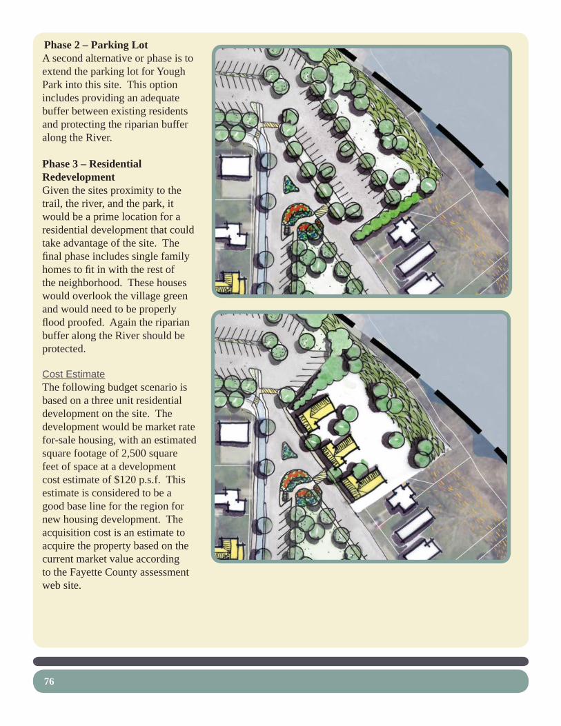
Phase 2 – Parking LotA second alternative or phase is to extend the parking lot for Yough Park into this site. This option includes providing an adequate buffer between existing residents and protecting the riparian buffer along the River.
Phase 3 – Residential RedevelopmentGiven the sites proximity to the trail, the river, and the park, it would be a prime location for a residential development that could take advantage of the site. The fi nal phase includes single family homes to fi t in with the rest of the neighborhood. These houses would overlook the village green and would need to be properly fl ood proofed. Again the riparian buffer along the River should be protected.
Cost EstimateThe following budget scenario is based on a three unit residential development on the site. The development would be market rate for-sale housing, with an estimated square footage of 2,500 square feet of space at a development cost estimate of $120 p.s.f. This estimate is considered to be a good base line for the region for new housing development. The acquisition cost is an estimate to acquire the property based on the current market value according to the Fayette County assessment web site.

77
Three unit housing developmentAcquisition $120,000Relocation $50,000Site preparation $50,000Development $900,000Other costs (soft costs) $100,000Total Estimate $1,220,000
Time FrameThis project can be implemented after funding is secured to relocate the existing beer distributor.

78
3. North First and Third Streets Planting This project involves planting beds, public art, parking, and open lawn space. The purpose is to:
Create a transition between Yough Park and the • neighborhood,Increase the property values of the neighborhood,• Create an added attraction for GAP trail users,• Provide unprogrammed open space as an addition to • Yough Park, andProvide event parking.•
Currently, this space is a sight for sore eyes. The overfl ow parking area is unorganized and unsightly. The corner is dominated by parked trucks and cars. Recommendations for this area includes following two projects.
Plant a Geranium Display in the IslandPlant several Geranium varieties to help promote the Geranium Festival in Connellsville.• Install fl agstone edging to provide a buffer and allow for safer maintenance.•
Create a Pervious Plaza Surrounded by PlantingsDesign a sculptural element for the center of the plaza.• Construct a seat wall facing the sculpture and village green area with views of the hills in the • background.Use native plantings.• Install fl agstone edging to match that of the Geranium Island display.• Install bike racks for trail users who would like to stop and enjoy the green space.•
Cost Estimate
Connellsville Gateway to Gateway Master PlanNorth First and Third Street Planting
Opinion of Probable Construction Costs - 2009
Item No. Item / Recommendation Quantity Unit Unit Cost Total Item Cost
1 Removals and Demolition $500 Remove existing trees 1 LS $500 $500
2 Site Improvements $30,354 Earthwork 20 CY $10 $200 Concrete sidewalks (leading to plaza) 27 SY $102 $2,754 Concrete curb 35 LF $34 $1,190 Crushed limestone 55 SY $22 $1,210

79
Flagstone edging 450 SF $20 $9,000 Concrete seat wall 1 EA $5,000 $5,000 Sculpture 1 LS $7,500 $7,500 Bike rack 1 EA $1,500 $1,500 Crosswalks 2 EA $1,000 $2,000
3 Landscaping $8,450 Flowering trees 6 EA $450 $2,700 Flower bed 1150 SF $5 $5,750
SUBTOTALS $39,304 Permitting 1 LS $1,000 $1,000 Mobilization 3 % $39,304 $1,179 Stake-Out 3 % $39,304 $1,179 Erosion & Sedimentation Control Measures 1 % $39,304 $393
Design and Engineering Fees 8 % $39,304 $3,144 Construction Contingency 10 % $39,304 $3,930
TOTAL $50,130
Time FrameWe expect that the North First and Third Street Plantings can be accomplished as soon as funding is available.


Plant Geranium Display- Use flagstone edging- Plant several Geranium varities
Create a Pervious Plaza- Design a sculptural element- Construct a seat wall- Use native plantings- Install flagstone edging- Install bike racks
Install Angled Parking- Approximately 30 spaces on west side of Village Green- Use pervious pavement- Install wheel stops- No curbs on new sidewalk
Create a Village Green- Use low mow grass for low maintenance- Collect excess runoff from adjacent pervious pavement
Install Parallel Parking- Approximately 30 spaces on northeast and south sides of Village Green
Install a Concrete Sidewalk- Extend sidewalk on 1st Street
First Street
First Street
Third StreetThird Street
HC
NORTH FIRST AND THIRD STREETS PLANTING / VILLAGE GNORTH FIRST AND THIRD STREETS PLANTING / VILLAGE GREEN
CONNELLSVILLE GATEWAY TO GATEWAY MASTER PLAN
INCOPRPORATED


83
4. Village GreenThis project involves parking and open lawn space. The purpose is to:
Create a transition between Yough Park and the neighborhood,• Increase the property values of the neighborhood,• Create an added attraction for GAP trail users,• Provide unprogrammed open space as an addition to Yough Park, and• Provide event parking.•
The existing overfl ow parking area is unorganized and unsightly. Recommendations for this area include the following:
Create a Village GreenRemove one block of North Second Street.• Use low mow grass seed mixture for low maintenance.• Plant native shade trees.• Create a native meadow on the southern side of the Green to reduce maintenance. •
Install Parallel Parking on First and Meason StreetsCreate approximately 30 spaces on the northeast and south sides of the Village Green.• Install bump outs with plantings to extend the green space and slow traffi c.•
Install Angled Parking on Third StreetCreate approximately 30 spaces on the west side of the Village Green.• Use pervious pavements to reduce stormwater runoff.• Install wheel stops instead of curbs to allow excess stormwater to fl ow into and infi ltrate into the • Village Green.
Install Concrete Sidewalks on First StreetExtend the existing sidewalks to connect the neighborhood with the new green space and Yough • Park.

84
Cost Estimate
Connellsville Gateway to Gateway Master PlanVillage Green - Phase 1
Opinion of Probable Construction Costs - 2009
Item No. Item / Recommendation Quantity Unit Unit Cost Total Item Cost
1 Removals and Demolition $10,020 Remove existing trees 1 LS $2,500 $2,500 Remove existing asphalt 610 SY $6 $3,660 Remove wooden bollards 1 LS $1,000 $1,000 Remove existing split rail fence 180 LF $2 $360 Remove dugout building 1 LS $2,500 $2,500
2 Site Improvements $197,010 Earthwork 2200 CY $10 $22,000 Concrete sidewalks (1st Street extension) 165 SY $102 $16,830
Concrete sidewalks (around village green) 500 SY $102 $51,000
Concrete curb 420 LF $34 $14,280 Asphalt paving (parallel parking) 420 SY $35 $14,700 Pervious paving (angled parking) 6270 SF $10 $62,700 Wheel stops 26 EA $250 $6,500 Benches 6 EA $1,500 $9,000
3 Landscaping $22,500 Shade trees 35 EA $500 $17,500 Seeding 50 MSF $100 $5,000
SUBTOTALS $229,530 Permitting 1 LS $5,000 $5,000 Mobilization 3 % $229,530 $6,886 Stake-Out 3 % $229,530 $6,886 Erosion & Sedimentation Control Measures 1 % $229,530 $2,295
Design and Engineering Fees 8 % $229,530 $18,362 Construction Contingency 10 % $229,530 $22,953
TOTAL $291,913

85
Connellsville Gateway to Gateway Master PlanVillage Green - Phase 2
Opinion of Probable Construction Costs - 2009
Item No. Item / Recommendation Quantity Unit Unit Cost
Total Item Cost
1 Removals and Demolition $6,610 Remove existing asphalt 135 SY $6 $810 Remove existing gravel parking 800 SY $1 $800 Remove existing house 1 LS $5,000 $5,000
2 Site Improvements $91,230 Earthwork 1100 CY $10 $11,000 Concrete sidewalks (around village green) 360 SY $102 $36,720
Concrete curb 540 LF $34 $18,360 Asphalt paving (parallel parking) 360 SY $35 $12,600 Pervious paving (angled parking) 855 SF $10 $8,550 Wheel stops 4 EA $250 $1,000 Benches 2 EA $1,500 $3,000
3 Landscaping $14,500 Shade trees 25 EA $500 $12,500 Meadow planting 0.8 AC $2,500 $2,000
SUBTOTALS $112,340 Permitting 1 LS $5,000 $5,000 Mobilization 3 % $112,340 $3,370 Stake-Out 3 % $112,340 $3,370 Erosion & Sedimentation Control Measures 1 % $112,340 $1,123
Design and Engineering Fees 8 % $112,340 $8,987 Construction Contingency 10 % $112,340 $11,234
TOTAL $145,425
Time FrameA fi rst phase of the Village Green can be implemented after the vehicles are removed from the City property and funding is secured. The fi rst phase includes all improvements associated with the Village Green located on existing City property.

86
The second phase includes acquiring the two properties located on Meason Street, when they become available, in order to complete the Village Green.

87
5. Third Street Streetscape ImprovementsThis project includes simple streetscape improvements to Third Street from one end to the other. The purpose is to increase bicycle safety, provide for pedestrian comfort, and enhance the visual appearance of Third Street. Improvements include:
Install colored asphalt to make the bike lanes more visible to • motorists.Plant more street trees to provide shade and soften buildings.• Install push buttons for bicyclists to cross Crawford Ave.• Install wayfi nding signs directing bicyclists towards the • Crawford Ave shops.
Cost Estimate
Connellsville Gateway to Gateway Master PlanThird Street Streetscape Improvements
Opinion of Probable Construction Costs - 2009
Item No. Item / Recommendation Quantity Unit Unit Cost
Total Item Cost
2 Site Improvements $28,900 Colored asphalt 2090 SY $5 $10,450 Push buttons at Crawford 2 EA $5,000 $10,000 “Bike Lane” or Bike Symbol 10 EA $250 $2,500 Straight Arrow 10 EA $150 $1,500 Bike Lane Striping 1,800 LF $0.25 $450 Wayfi nding signs 4 EA $1,000 $4,000
3 Landscaping $17,500 Shade trees 35 EA $500 $17,500
SUBTOTALS $46,400 Permitting 1 LS $1,000 $1,000 Mobilization 3 % $46,400 $1,392 Stake-Out 3 % $46,400 $1,392 Erosion & Sedimentation Control Measures 1 % $46,400 $464
Design and Engineering Fees 8 % $46,400 $3,712 Construction Contingency 10 % $46,400 $4,640
TOTAL $59,000
Time FrameThird Street Streetscape Improvements can be implemented as soon as funding is secured.

88
6. Third Street Residential InfillThis project involves building new homes in void spaces along Third Street that fi t in with the existing neighborhood character. The purpose is to strengthen the look and vitality of the neighborhood. Infi ll houses should be of high quality, fl ood proofed, and refl ect similar setbacks and styles of surrounding houses.
Cost EstimateThree sites were identifi ed as potential infi ll locations, in addition to a subdivision of the land with the current building proposed as a location for a bed and breakfast.
Three Residential Infi ll Developments on Third StreetAcquisition $10,000Site preparation $50,000Development $900,000Other costs (soft costs) $100,000Total Estimate $1,060,000
Time FrameResidential infi ll is expected to happen over time as demand for quality housing in the neighborhood increases due to other improvements such as the Village Green.

89
7. Historic Restoration AreaThis project involves restoring a beautiful historic home located at 223 North 3rd Street. There has been recent interest to create a bed and breakfast at the site. Single-family residential is also a compatible use for this site. Restoration needs to include fl ood proofi ng since the house is located within the 100 year fl ood plain.
Cost EstimatesThe following costs estimated were provided to rehabilitate the bed and breakfast building.
Historic Rehabilitation on Third Street: B and B BuildingAcquisition $100,000Site preparation $0Development $500,000Other costs (soft costs) $100,000Total Estimate $700,000

90
8. Meason Street Residential RedevelopmentThis project involves building new homes facing the Village Green on Meason Street. These homes should be properly fl ood proofed because of being within the fl ood plain. The purpose is to strengthen the look and vitality of the neighborhood.
Cost EstimateThis estimate is for six units of single-family housing facing the park. In addition, enhancing the park will add to the attractiveness of the area and the utility of the green space.
Two phased process for the park areaAcquisition $300,000Relocation $50,000Site preparation $50,000Development $180,000Other costs (soft costs) $100,000Total Estimate $2,300,000
Time FrameNew homes can be built as property becomes available. Funding can be sought to properly relocate the beer distributor located on Meason and First Streets.

91
9. Crawford Ave Streetscape ImprovementsThe purpose of these improvements is to create a pedestrian and bicycle friendly street that supports businesses on both the west and east sides of Crawford Ave. Currently, the street is devoid of trees, lacking good crosswalks, full of overhead utilities, and defi cient of visual interest. Streetscape improvements include:
Install brick crosswalk.• Install bump outs with integrated rain gardens to • capture stormwater runoff.Plant street trees.• Install banners and hanging baskets on existing light • poles.Install wayfi nding signs at intersections directing visitors to the • GAP, trail parking, public parking, and downtown.Install Sharrows, or Shared Use Lane Markings, along the • Crawford and the Inter-City Loop Trail.Relocate utilities to rear parking lots.• Install benches.•
Cost EstimateThe following cost estimates are based on proposed improvements for one block of Crawford Ave. Streetscape improvements to 3½ blocks of west Crawford Ave will cost about $811,300.
Connellsville Gateway to Gateway Master PlanCrawford Ave Streetscape Improvements per Block
Opinion of Probable Construction Costs - 2009
Item No. Item / Recommendation Quantity Unit Unit Cost Total Item Cost
1 Removals and Demolition $3,810 Remove existing asphalt 525 SY $6 $3,150 Remove existing concrete curb 330 LF $2 $660
2 Site Improvements $90,630 Concrete sidewalk (bump outs) 65 SY $102 $6,630 Concrete curb 200 LF $34 $6,800 Brick crosswalks 1250 SF $26 $32,500 Sharrows 2 EA $100 $200 Benches 2 EA $1,500 $3,000 Trash cans 2 EA $1,000 $2,000 Wayfi nding signs 2 EA $1,000 $2,000

92
Light posts with hanging baskets and banners poles 5 EA $7,500 $37,500
3 Landscaping $17,000 Shade trees 10 EA $500 $5,000 Rain garden plantings 4 EA $3,000 $12,000
4 Utilities $70,000 Rain garden outlets and storm connections 4 EA $5,000 $20,000
Relocate overhead utilities 1 LS $50,000 $50,000 SUBTOTALS $181,440
Permitting 1 LS $5,000 $5,000 Mobilization 3 % $181,440 $5,443 Stake-Out 3 % $181,440 $5,443 Erosion & Sedimentation Control Measures 1 % $181,440 $1,814
Design and Engineering Fees 8 % $181,440 $14,515 Construction Contingency 10 % $181,440 $18,144
TOTAL $231,800
Time FrameImprovements to Crawford Ave can be implemented as soon as funding has been secured. The streetscape can be constructed in phases focusing on the Gateway to Gateway and Downtown areas fi rst, and then stretching to Route 119. Relocating utilities can also be accomplished as a later phase.

93
10. Third and Crawford Redevelopment AreaThe purpose of this redevelopment area is to enhance the major crossroads between the GAP and Crawford in order to best take advantage of trail related tourism. This area involves the following redevelopment and infi ll projects that will create a concentrated mix of uses serving both trail users and local residents:
Northeast Corner Redevelopment
This project is the most important in the Gateway to Gateway Master Plan because it provides the best opportunity to capture trail related tourism. Involving two different properties, this project includes:
Construct a Bicycle Plaza• Design the plaza around a bicycle theme.o Install covered bike racks and bike lockers.o Install a kiosk with brochures of City o information.Construct planters with trees and benches.o Install a drinking fountain.o Install an air pump for bicyclists.o

94
Infi ll with a Two-Story, Flood Proofed, Mixed-Use Building (9,500 sf per fl oor)• Allow retail on the ground fl oor and offi ce or residential on the second fl oor.o Potential uses include a hostel or other overnight facility and retail shops.o Include public restrooms and shower facilities.o
Construct a Rear Parking Lot• Plant a hedge to screen the lot from adjacent o land uses.Install bio-swales to collect stormwater runoff.o Include 39 spaces and two accessible spaces.o
Create Pedestrian Access Connecting the Parking Lot • to Crawford Ave
Install a wide sidewalk lined with low o plantings and trees.
Install Angled Parking on Third Street• Install approximately 15 spaces along the fi rst o block north of Crawford.Install rain gardens to capture stormwater runoff.o
Cost Estimate
3rd and Crawford - Northeast Corner RedevelopmentAcquisition $125,000Relocation $100,000Site preparation $20,000Development $2,850,000Other costs (soft costs) $250,000Total Estimate $3,345,000
North Third Street Mixed-Use Infi ll ProjectThis project will fi ll in a current void space on Third Street and contribute to the concentration of businesses located in this area. The project involves the following:
Construct a two-story, fl ood proofed, mixed-use • building (5,000 sf per fl oor) with retail on the ground fl oor and offi ce or residential on the second fl oor.Create parking in the rear.• Install a sidewalk to the front of the building.•

95
Cost Estimate
3rd and Crawford - North 3rd Mixed-use Infi llAcquisition $6,000Site preparation $5,000Development $1,500,000Other costs (soft costs) $20,000Total Estimate $1,531,000
Third Street Commercial Conversion ProjectWe envision the only remaining house on this block of Third Street to be converted into a commercial use over time with available parking in the rear.
Crawford Ave Mixed-Use Infi ll ProjectsThese two projects include constructing two-story mixed-use buildings with retail on the ground fl oor and offi ce or residential on the second fl oor. One includes 1,225 square feet per fl oor and the other 2,100 square feet per fl oor. Parking should be considered in the rear where feasible.
Cost Estimate
3rd and Crawford - Mixed-use Infi ll ProjectsAcquisition $15,000Site preparation $10,000Development $1,000,000Other costs (soft costs) $15,000Total Estimate $1,040,000
Time FrameThe projects included in the Third and Crawford Redevelopment Area are dependent on the current land owners. Securing funding for relocating and acquiring the properties involved in the Northeast Corner Project are a priority.


Construct a Parking Lot- Plant a hedge to screen from adjacent land uses- Install bio-swales to collect stormwater
Create Pedestrian Access- Install a wide sidewalk lined with low plantings and trees
Construct a Bicycle Plaza- Design the plaza around a bicycle theme- Install covered bike racks and bike lockers- Install a Kiosk with brochures of City information- Construct planters with trees and benches- Install a drinking fountain- Install an air pump
Improve Third Street- Color bike lanes- Plant more trees of east side of the Street- Install push buttons for bicyclists at Crawford Ave
Improve Crawford Ave- Install brick crosswalks- Install bump outs with integrated rain gardens- Plant street trees- Install banners and hanging baskets on light poles- Install wayfinding signs at intersections- Install Sharrows along Inter-City Loop Trail- Relocate utilities to rear parking lots- Install benches
Install Angled Parking- Install along the first block of Third Street north of Crawford Ave - Install rain gardens to capture stormwater
Infill with Mixed-Use- Retail on ground floor with office or residential on second floor- Parking in rear
Infill with Mixed-Use- Retail on ground floor with office or residential on second floor
Infill with Mixed-Use- Retail on ground floor with office or residential on second floor- Potential hostel- Include public restroom and shower facilities
Infill with Mixed-Use- Retail on ground floor with office or residential on second floor- Parking in rear
Convert to Commercial- Parking in rear
Crawford AveCrawford Ave
Third
Str
eet
Third
Str
eet
Seco
nd S
tree
tSe
cond
Str
eet
THIRD AND CRAWFORD REDEVELOPMENT AREA / STREETSCAPE IMPROVEMENTSTHIRD AND CRAWFORD REDEVELOPMENT AREA / STREETSCAPE IMPROVEMENTS
CONNELLSVILLE GATEWAY TO GATEWAY MASTER PLAN
INCOPRPORATED


99
11. First and Crawford Redevelopment AreaThe purpose of this redevelopment area is to enhance the major connection between the GAP and Downtown. This area involves the following redevelopment and infi ll projects serving both trail users and local residents:
Northeast Corner Redevelopment
This project provides for riverfront access, river views, gateway into downtown, and anchors the existing vacant corner. Currently, the existing property owner is willing to sell if the City maintains the site as a park for around 20 years. At the same time, this corner is considered a high priority economic redevelopment site connecting the GAP to downtown. Boat access at this location is intended to be an amenity associated with the commercial development at the top of the bank. This is not a “public access” boat launch area as that is more easily achieved with better grades and more convenient parking at Yough Park a very short distance from this site. This boat access would probably be built as part of the commercial development and not with public funds. Handicap access would most likely be internal to the building construction. Therefore, we recommend the following two phases for this site:
Phase one includes:Construct a plaza with bicycle amenities • such as bike racks, bike lockers, seating, and a drinking fountain.Construct a clock tower at the street corner • to draw peoples eyes toward downtown.Create docks for public boat access along • with reconstruction of the existing stairs and a new path leading up to the new parking area.Construct a small parking lot with • screening from adjacent land uses.This may be an ideal location to display • old trams that the City owns.
Phase two includes:Construct a fl ood proofed, two-story (9,200 sf per fl oor) building that fronts Crawford Ave and • wraps around to offer views of the River. A large deck overlooking the River provides outdoor

100
seating. A bell or clock tower rising from the corner helps create a visual connection between the GAP and downtown. Suggested uses for the building, brought up during meetings include a restaurant along with shops related to river trail users. Adjust access to docks built in Phase I in • response to building construction.Construct a parking lot for approximately • 20 spaces including one accessible space. The parking lot should include bio-swales to collect stormwater runoff and screening from adjacent land uses.
Cost Estimate
1st and Crawford: Northeast Corner Redevelopment (phase two)Acquisition $118,000Relocation $0Site preparation $20,000Development $2,895,000Other costs (soft costs) $250,000Total Estimate $3,283,000
Southeast Corner PlantingThe purpose of this project is to soften the building on the corner, remove excessive impervious surfaces, and provide a gateway between the east and west sides of Crawford Ave. Recommendations include:
Remove excessive asphalt and concrete near the • corner of the building.Relocate the sidewalk closer to the street to line up • with the bridge sidewalks.Plant shrubs and shade trees in a new planting bed.• Talk with adjacent land owners to relocate the existing • parking lot access to First Street.

101
Cost Estimate
Connellsville Gateway to Gateway Master PlanSoutheast Corner Planting
Opinion of Probable Construction Costs - 2009
Item No. Item / Recommendation Quantity Unit Unit Cost
Total Item Cost
1 Removals and Demolition $1,390 Remove existing asphalt 115 SY $6 $690 Remove existing concrete walk 70 SY $10 $700
2 Site Improvements $10,180 Topsoil 40 CY $25 $1,000 Concrete sidewalk 70 SY $102 $7,140 Concrete curb 60 LF $34 $2,040
3 Landscaping $4,375 Shade trees 1 EA $500 $500 Perennials 400 SF $5 $2,000 Flowering shrubs 25 EA $75 $1,875
SUBTOTALS $15,945 Permitting 1 LS $5,000 $5,000 Mobilization 3 % $15,945 $478 Stake-Out 3 % $15,945 $478 Erosion & Sedimentation Control Measures 1 % $15,945 $159
Design and Engineering Fees 8 % $15,945 $1,276 Construction Contingency 10 % $15,945 $1,595
TOTAL $24,931
Northwest Corner Building Addition and Parking LotThe purpose of this project is to provide additional parking for apartment residents and add more retail space that compliments the Northeast Corner Project. Recommendations include:
Construct a two-story (1,800 sf per fl oor) mixed-use • addition.Install approximately eleven parking spaces including • one accessible space in the rear.Plant a vegetative screen next to adjacent land uses.•
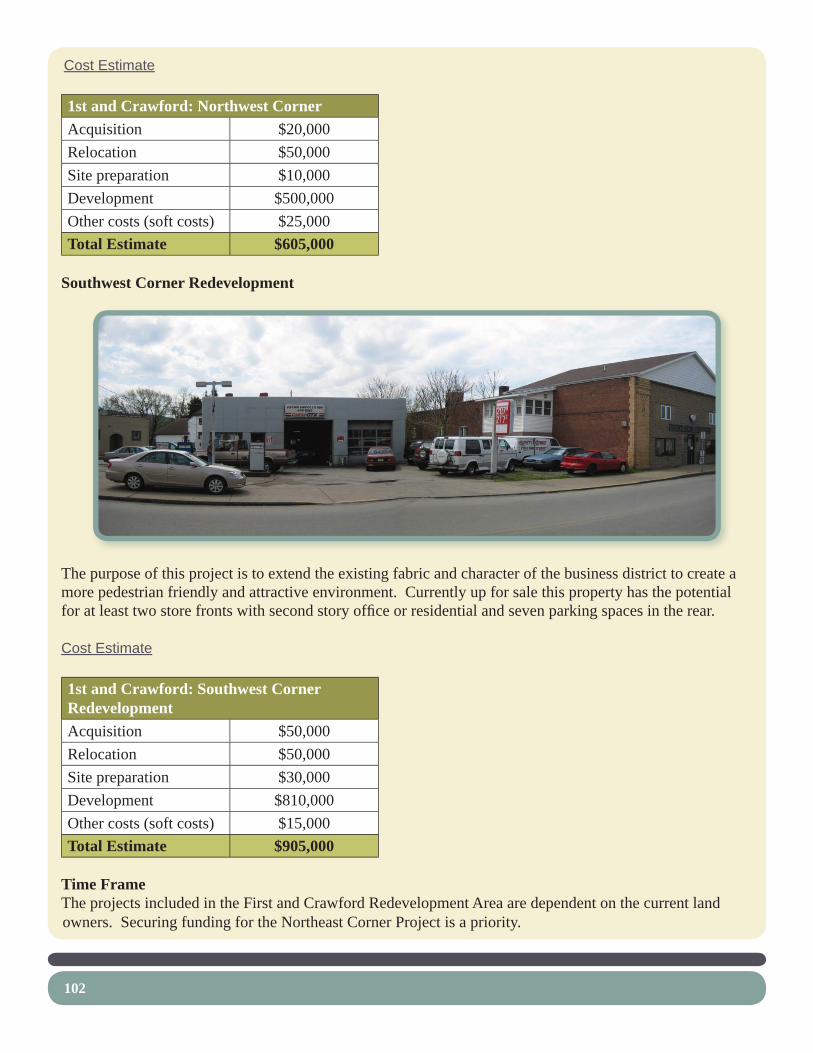
102
Cost Estimate
1st and Crawford: Northwest CornerAcquisition $20,000Relocation $50,000Site preparation $10,000Development $500,000Other costs (soft costs) $25,000Total Estimate $605,000
Southwest Corner Redevelopment
The purpose of this project is to extend the existing fabric and character of the business district to create a more pedestrian friendly and attractive environment. Currently up for sale this property has the potential for at least two store fronts with second story offi ce or residential and seven parking spaces in the rear.
Cost Estimate
1st and Crawford: Southwest Corner RedevelopmentAcquisition $50,000Relocation $50,000Site preparation $30,000Development $810,000Other costs (soft costs) $15,000Total Estimate $905,000
Time FrameThe projects included in the First and Crawford Redevelopment Area are dependent on the current land owners. Securing funding for the Northeast Corner Project is a priority.

103
12. Hillside Screening
The purpose of this project is to screen views of industrial uses adjacent to the GAP bike lanes on South Third Street. This area should be planted with a variety of shade trees and shrubs.
Cost Estimate
Connellsville Gateway to Gateway Master PlanHillside Screening
Opinion of Probable Construction Costs - 2009
Item No. Item / Recommendation Quantity Unit Unit Cost
Total Item Cost
1 Removals and Demolition $500 Remove existing lawn area for plantings 1 LS $500 $500
3 Landscaping $14,475 Shade trees 12 EA $500 $6,000 Evergreen trees 22 EA $300 $6,600 Flowering shrubs 25 EA $75 $1,875
SUBTOTALS $14,975 Design and Engineering Fees 8 % $14,975 $1,198 Construction Contingency 10 % $14,975 $1,498
TOTAL $17,671
Time FramePublic Right-of-Way limits should be checked fi rst. If the planted area extends into the adjacent property, an agreement should be made with the owner to get permission for this project.

104
13. South First and Third Greening and OverlookThe purpose of this project is to enhance the transition between neighborhood bike lanes and the more industrial section of the GAP trail in Connellsville. This project actually consists of several smaller projects which include:
South First Street Reconfi guration
This project involves the reduction of excessive asphalt. Recommendations include:Reconfi gure the Intersection of First Street and Industrial Building Driveway•
Reduce excessive lane widths and asphalt pavement area.o Create more green space with shade trees.o Create a crosswalk and sidewalk connection to the existing playground.o
Plant a Geranium Display• Mark the transition between the trail and bike lanes (just like the other end).o
Cost Estimate
Connellsville Gateway to Gateway Master PlanSouth First Street Reconfi guration
Opinion of Probable Construction Costs - 2009
Item No. Item / Recommendation Quantity Unit Unit Cost
Total Item Cost
1 Removals and Demolition $750 Remove existing asphalt 125 SY $6 $750
2 Site Improvements $3,530 Topsoil 40 CY $25 $1,000 Concrete sidewalks 15 SY $102 $1,530 Crosswalk 1 LS $1,000 $1,000
3 Landscaping $2,800 Shade trees 4 EA $500 $2,000

105
Seeding 1 MSF $100 $100 Flower bed areas 2 EA $350 $700
SUBTOTALS $7,080 Permitting 1 LS $1,000 $1,000 Mobilization 3 % $7,080 $212 Stake-Out 3 % $7,080 $212 Erosion & Sedimentation Control Measures 1 % $7,080 $71 Design and Engineering Fees 8 % $7,080 $566 Construction Contingency 10 % $7,080 $708
TOTAL $9,850
Daycare Building GreeningCreate a New Building Entrance for the Daycare•
Replace excessive pavement with planting areas.o Install sidewalks around the building to connect entrances.o Restripe the parking stalls.o
Plant Rain Gardens• Divert water from the building’s downspouts into rain gardens.o
Cost Estimate
Connellsville Gateway to Gateway Master PlanDaycare Building Greening
Opinion of Probable Construction Costs - 2009
Item No. Item / Recommendation Quantity Unit Unit Cost
Total Item Cost
1 Removals and Demolition $2,100 Remove existing asphalt 350 SY $6 $2,100
2 Site Improvements $33,730 Topsoil 120 CY $25 $3,000 Concrete walks 90 SY $102 $9,180 Concrete curb 325 LF $34 $11,050 Linestriping 1 LS $500 $500 Underdrainage 1 EA $5,000 $5,000 Overfl ow outlet and storm connection 2 EA $2,500 $5,000
3 Landscaping $8,655 Shade trees 4 EA $500 $2,000 Groundcover (assumes 12” O.C. spacing) 350 EA $2.80 $980

106
Rain garden perennials 850 SF $5 $4,250 Flowering shrubs 19 EA $75 $1,425
SUBTOTALS $44,485 Permitting 1 LS $1,000 $1,000 Mobilization 3 % $44,485 $1,335 Stake-Out 3 % $44,485 $1,335 Erosion & Sedimentation Control Measures 1 % $44,485 $445 Design and Engineering Fees 8 % $44,485 $3,559 Construction Contingency 10 % $44,485 $4,449
TOTAL $56,606
Industrial Warehouse GreeningCreate a Planting Bed at the Industrial Warehouse•
Replace excess pavement with plantings to soften the building adjacent to the Daycare.o
Cost Estimate
Connellsville Gateway to Gateway Master PlanIndustrial Warehouse GreeningOpinion of Probable Construction Costs - 2009
Item No. Item / Recommendation Quantity Unit Unit Cost
Total Item Cost
3 Landscaping $885 Groundcover (assumes 12” O.C. spacing) 75 EA $2.80 $210
Flowering shrubs 9 EA $75 $675 SUBTOTALS $885
Construction Contingency 10 % $885 $89 TOTAL $974

107
South First and Third Overlook
This project involves enhancing the existing overlook area:Install pervious pavement with fl agstone edging.• Construct a seat wall.• Install a decorative railing.• Plant native species around the overlook.• Install interpretive signs focused on the River and railroad tracks.• Restore the riparian buffer by removing invasives and planting natives.•
Cost Estimate
Connellsville Gateway to Gateway Master PlanSouth First and Third OverlookOpinion of Probable Construction Costs - 2009
Item No. Item / Recommendation Quantity Unit Unit Cost
Total Item Cost
1 Removals and Demolition $1,350 Remove encroaching trees and shrubs 1 LS $1,000 $1,000 Remove existing bench 1 LS $100 $100 Remove existing bulletin board 1 LS $250 $250
2 Site Improvements $14,605 Earthwork 20 CY $10 $200 Crushed limestone 15 SY $22 $330 Flagstone edging 100 SF $20 $2,000 Concrete seat wall 1 EA $5,000 $5,000

108
Asphalt paths (6’ wide) 45 SY $35 $1,575 Decorative barrier railing 50 LF $50 $2,500 Interpretive sign 2 EA $1,500 $3,000
3 Landscaping $2,925 Flowering trees 4 EA $450 $1,800 Flower bed 225 SF $5 $1,125
SUBTOTALS $18,880 Permitting 1 LS $1,000 $1,000 Mobilization 3 % $18,880 $566 Stake-Out 3 % $18,880 $566 Erosion & Sedimentation Control Measures 1 % $18,880 $189
Design and Engineering Fees 8 % $18,880 $1,510 Construction Contingency 10 % $18,880 $1,888
TOTAL $24,600
Time FrameThe South First and Third Greening projects need approval and commitment from the property owners and the City. The Overlook can be accomplished as soon as funding is secured.

Plant Geranium Display- Mark transition between trail and bike lanes
Reconfigure Intersection- Reduce excessive lane widths and asphalt pavement area- Create more green space with shade trees- Create a crosswalk and sidewalk connection to existing playground
Create an Overlook- Install pervious pavement with flagstone edging- Construct a seat wall- Plant native species- Install interpretive signs focused on the River and railroad tracks
Restore Riparian Buffer- Remove invasives and plant natives
Plant a Rain Garden- Divert water from building down spout
Plant a Rain Garden- Divert water from building down spout
Create a Planting Bed- Replace excess pavement with plantings to soften building
Create a New Building Entrance- Replace excess pavement with planting areas- Install sidewalks- Restripe parking stalls
Existing PlaygroundExisting Playground
Firs
t Stre
et
Firs
t Stre
et
Existing Daycare Center
Existing Daycare Center
SOUTH FIRST AND THIRD GREENING AND OVERLOOKSOUTH FIRST AND THIRD GREENING AND OVERLOOK
CONNELLSVILLE GATEWAY TO GATEWAY MASTER PLAN
INCOPRPORATED


111
14. Facade Improvement AreaThe purpose of this recommendation is to help concentrate facade improvement funding for the businesses adjacent to the GAP. This will create a quicker and stronger impact than if funding was spread over a larger area.

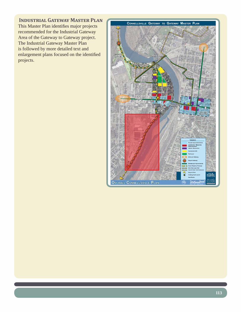
113
INDUSTRIAL GATEWAY MASTER PLANThis Master Plan identifi es major projects recommended for the Industrial Gateway Area of the Gateway to Gateway project. The Industrial Gateway Master Plan is followed by more detailed text and enlargement plans focused on the identifi ed projects.

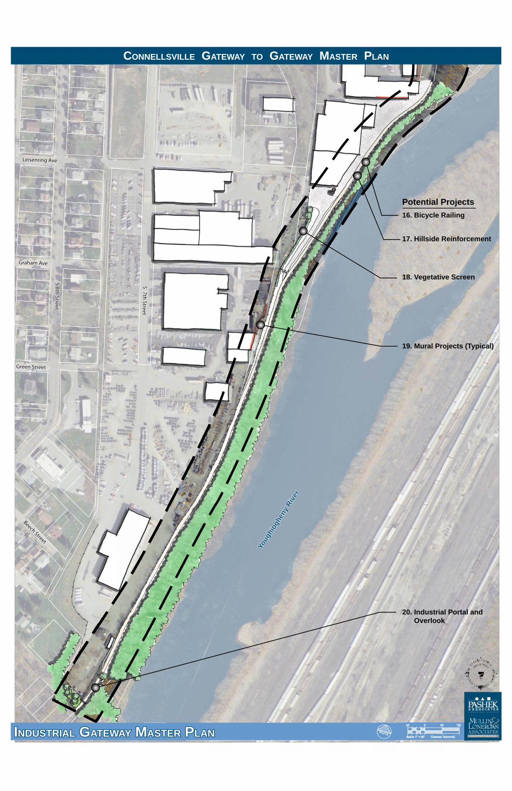
Green StreetGreen Street
Beech Street
Beech Street
Leisenring AveLeisenring Ave
Graham AveGraham Ave
S` 7th Street
S` 7th Street
S 8th Street
S 8th Street
Youg
hiog
heny
Riv
er
Youg
hiog
heny
Riv
er
16. Bicycle Railing
Potential Projects
17. Hillside Reinforcement
18. Vegetative Screen
19. Mural Projects (Typical)
20. Industrial Portal and Overlook
INDUSTRIAL GATEWAY MASTER PLANINDUSTRIAL GATEWAY MASTER PLAN
CONNELLSVILLE GATEWAY TO GATEWAY MASTER PLAN
INCOPRPORATED


117
15. Bicycle Railing along Steep Slopes
The purpose of this project is to provide an attractive, low-maintenance barrier that will protect bicyclists from potentially falling down the slope, help bicyclists feel safe, allow views of the River, and allow safe site distances around corners.
Currently, chain-link fencing (approximately six feet high) exists along portions of the industrial section of the GAP, protecting bicyclists from steep slopes leading down to Youghiogheny River. This fencing, while providing a necessary function, has several drawbacks. They include:
Limited site distances around corners – The height of the fencing restricts bicyclists’ vision around • corners where the trail narrows, thereby increasing the potential for collisions with oncoming bicyclists.Limited views of the River – The • height of the fencing restricts views of the River.Aesthetically unpleasing • appearance – Chain-link fencing is usually portrayed as a cheaper, more unsightly fence option compared to most other fence materials and designs.
Railing HeightSeveral organizations have specifi ed heights for bicycle barrier railings. The American Association of State Highway Transportation Offi cials (AASHTO) “Guide for the Development of Bicycle Facilities” (1999) specifi es a minimum railing height of 42” while their “Standard Specifi cations for Highway Bridges” (2002) specifi es a minimum of 54” for bicycle railings on bridges. PennDOT has adopted a standard of 42” for both bridge railings and shared use path railings designed for bicyclists.
In 2004, the National Cooperative Highway Research Program (NCHRP) funded a study to resolve the inconsistency between these standards. According to the NCHRP’s “Determination of Appropriate Railing Heights for Bicyclists” (Project 20-7/task 168) a 48” bicycle railing should be used where a shared use path is adjacent to a hazard such as a cliff, water body, or rocks. An exception to this standard is when there is potential for vaulting over a railing where a bicyclist’s speed may project him or her over an outside curve. More specifi cs on these exceptions can be found within the NCHRP’s document. In the case of Connellsville, a 48” bicycle railing would suffi ce according to this document.

118
Railing Design and MaterialsThe railing should be low maintenance and durable. Therefore, we recommend using an attractive metal cable or mesh railing. Although more expensive than wood, steel or aluminum will be less costly to maintain and will last longer.
Cost Estimate
Connellsville Gateway to Gateway Master PlanBicycle Railing
Opinion of Probable Construction Costs - 2009
Item No. Item / Recommendation Quantity Unit Unit Cost
Total Item Cost
1 Removals and Demolition $3,700 Remove encroaching shrubs and trees 1 LS $2,000 $2,000 Remove existing chain link fence 850 LF $2 $1,700
2 Site Improvements $72,250 Bicycle railing 850 LF $85 $72,250
SUBTOTALS $75,950 Design and Engineering Fees 8 % $41,950 $6,076 Construction Contingency 10 % $41,950 $7,595
TOTAL $89,621
Time FrameThis project can be implemented as soon as Ohiopyle State Park approves the railing type and when funding can be secured.

119
16. Vegetative ScreenThe purpose of this project is to screen some of the more unattractive industrial areas along this portion of the Trail. Recommendations include planting a low hedge and some trees along the industry side of the Trail maintenance access. Care should be given so as to not block views of the silo public art piece.
Cost Estimate
Connellsville Gateway to Gateway Master PlanVegetative Screen
Opinion of Probable Construction Costs - 2009
Item No. Item / Recommendation Quantity Unit Unit Cost
Total Item Cost
1 Removals and Demolition $500 Remove existing lawn area for plantings 1 LS $500 $500
2 Landscaping $6,250 Shade trees 2 EA $500 $1,000 Flowering shrubs 70 EA $75 $5,250
SUBTOTALS $6,750 Design and Engineering Fees 8 % $6,750 $540 Construction Contingency 10 % $6,750 $675
TOTAL $7,965
Time FrameThis project can be implemented as soon as the proper approvals are acquired and funding is secured.

120
17. Mural Projects
The purpose of these projects are to beautify otherwise dull areas along portions of the Trail. Opportunities also exist to use the murals for interpretation.
Time FrameThe murals can be implemented when funding and property owner approval is secured. Some murals, such as along an existing wall have already been completed.
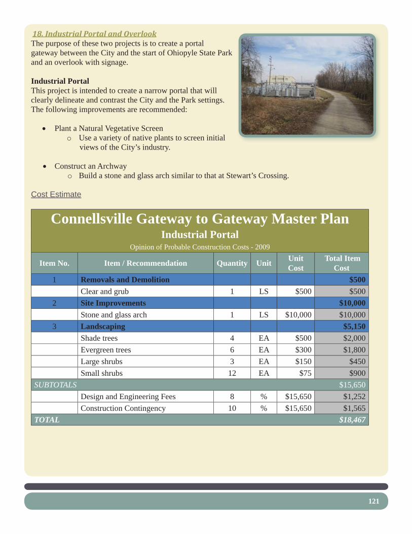
121
18. Industrial Portal and OverlookThe purpose of these two projects is to create a portal gateway between the City and the start of Ohiopyle State Park and an overlook with signage.
Industrial PortalThis project is intended to create a narrow portal that will clearly delineate and contrast the City and the Park settings. The following improvements are recommended:
Plant a Natural Vegetative Screen• Use a variety of native plants to screen initial o views of the City’s industry.
Construct an Archway• Build a stone and glass arch similar to that at Stewart’s Crossing.o
Cost Estimate
Connellsville Gateway to Gateway Master PlanIndustrial Portal
Opinion of Probable Construction Costs - 2009
Item No. Item / Recommendation Quantity Unit Unit Cost
Total Item Cost
1 Removals and Demolition $500 Clear and grub 1 LS $500 $500
2 Site Improvements $10,000 Stone and glass arch 1 LS $10,000 $10,000
3 Landscaping $5,150 Shade trees 4 EA $500 $2,000 Evergreen trees 6 EA $300 $1,800 Large shrubs 3 EA $150 $450 Small shrubs 12 EA $75 $900
SUBTOTALS $15,650 Design and Engineering Fees 8 % $15,650 $1,252 Construction Contingency 10 % $15,650 $1,565
TOTAL $18,467

122
Industrial OverlookThis project acts as a welcome for those entering the City. Recommendations include:
Create an Overlook on the river side of the Trail• Install pervious pavement with fl agstone edging.o
Install a bench.• Plant a tree for shade.o
Install a Kiosk Opposite the Overlook• Focus on interpreting the industry of Connellsville and general information about the City.o
Restore the Riparian Buffer• Replace invasive plants with natives.o
Cost Estimate
Connellsville Gateway to Gateway Master PlanIndustrial Overlook
Opinion of Probable Construction Costs - 2009
Item No. Item / Recommendation Quantity Unit Unit Cost
Total Item Cost
1 Removals and Demolition $350 Remove existing bench 1 LS $100 $100 Remove existing lawn area 1 LS $250 $250
2 Site Improvements $8,520 Earthwork 8 CY $10 $80 Crushed limestone 20 SY $22 $440 Flagstone edging 75 SF $20 $1,500 Bench 1 EA $1,500 $1,500 Kiosk 1 EA $5,000 $5,000
3 Landscaping $500 Shade trees 1 EA $500 $500
SUBTOTALS $9,370 Erosion & Sedimentation Control Measures 1 % $9,370 $94
Design and Engineering Fees 8 % $9,370 $750 Construction Contingency 10 % $9,370 $937
TOTAL $11,150
Time FrameThese two projects can be implemented as soon as funding becomes available.

Install a Kiosk- Focus on interpreting the industry of Connellsville and general information about the City
Create an Overlook- Install pervious pavement with flagstone edging- Install a bench- Plant a shade tree
Restore Riparian Buffer- Remove invasives and plant natives
Plant a Natural Vegetative Screen- Use a variety of native plants
Construct an Archway- Build a stone and glass arch similar to that at Stewart’s Crossing
Existing Allegheny Power Property
Existing Allegheny Power Property
Existing Wet AreaExisting Wet Area
INDUSTRIAL PORTAL AND OVERLOOKINDUSTRIAL PORTAL AND OVERLOOK
CONNELLSVILLE GATEWAY TO GATEWAY MASTER PLAN
INCOPRPORATED


125
OPINION OF PROBABLE CONSTRUCTION COSTSThe previous opinions of probable costs were based on the assumption that implementation will occur through a public bidding process, utilizing the Commonwealth of Pennsylvania’s 2009 Prevailing Wage Rates. To budget for infl ation of costs for future improvements, we recommend a four and one-half percent (4.5%) annual increase be budgeted for all work occurring after 2009.
In Pennsylvania, all projects over $25,000 are required to use the State’s Prevailing Wage Rates for Construction. However, volunteer labor, as well as in-kind services, donated equipment and materials, may reduce construction costs. The City may choose to construct some of the facilities using in-kind services, volunteer services and/or donated labor or materials. It is anticipated that this would also reduce the projected construction costs. Additionally, alternate sources of funding, including grant opportunities identifi ed herein, may help to offset the expense to the City.

126
PHASING PLANWe recommend the improvements to the Connellsville Gateway to Gateway Master Plan be constructed in a series of logical phases. Depending on the City’s fi nancial situation, and the success of grant writing efforts, this phasing plan may be expedited, or lengthened, depending on the fi nancial capabilities of the City.
Funding has been lined up for the following fi rst three phases of this Master Plan:
Phase 1 - CDBG funds have been acquired for the following projects in Yough Park and Stewarts Crossing:Boundary Survey- Widmer contract, $4000 completed• Relocate fence around Sanitary pump building• Construct café-kiosk plaza and trail in front of Cream of the Trail Building• Renovations to Cream of the Trail• Paving trail through Park• Removal of boardwalk- completed• Clearing views to river-- completed • Parking lot work on Stewarts Crossing•
Phase 2 - Application for DCNR C2P2 funds has been submitted for the following projects in Yough Park, Stewarts Crossing, and North Third and First Streets Planting:
Additions to Cream of Trail building including wash, ADA bathroom, Bike Racks• Riverbank stabilization• Additional parking access completed in Stewarts Crossing• North Third and First Streets Planting•
Additional CDBG funds will be used in phase two for a new playground in Yough Park.
Phase 3 – Remaining DCNR funding from the Connellsville Gateway to Gateway Master Plan will allow for the construction of the Torrance Ave Bikeway.

appendices
127


funding sources


Funding Opportunities Many agencies provide grants to assist in providing financial resources to implement design and construction of facilities similar to those proposed for the Connellsville Gateway to Gateway Master Plan. Some offer grants to implement educational programs in concert with these facilities. Still others support the planning and implementation of projects with preserve habitat. Assistance can also take the form of technical help, information exchange, and training. Submission of a thorough application may result in award of monies, given the competition for grant funding. Strategies for improving the chances of receiving a grant include:
• Being well-prepared by knowing the funding agency (contact persons, addresses, phone numbers); ensuring your agency or municipality (if submitting on your behalf) and the project are eligible; and submitting a complete and accurate application ahead of the deadline.
• Clearly indicate the funding agency’s vision and plans in the application, to portray
where your project fits their goals. Describe how matching funds such as private contributions and other grants will leverage the funding. Describe how maintenance of the site will be accomplished, to help justify the request for the grant. Show past successes within the Borough such as how past recreation projects were funded and built, and how this project impacts those successes.
• Contacting the funding agencies by personally meeting with them to show your
commitment to the project. Based on the potential funding sources for the project, we recommend the Borough pursue, at a minimum, the following grant opportunities: Community Conservation Partnerships Programs Agency: Department of Conservation & Natural Resources Program Goals: To develop and sustain partnerships with communities, non-profits and other organizations for recreation and conservation projects and purposes. The Bureau of Recreation and Conservation is responsible for fostering, facilitating and nurturing the great majority of these partnerships through technical assistance and grant funding from the Community Conservation Partnerships Programs. Program Restrictions: See DCNR grant application manual for the Community Conservation Partnerships Program, as program restrictions vary by type. Use of Funds: Planning and Technical Assistance; Comprehensive Recreation, Park and Open Space Plans; Conservation Plans; County Natural Area Inventories; Feasibility Studies; Greenways and Trails Plans; Rails-to-Trails Plans; Master Site Plans; River Conservation Plans; Education and Training; Peer-to-Peer; Circuit Rider; Acquisition Projects; Park and Recreation Areas; Greenways, Trails and Rivers Conservation; Rails-to-Trails; Natural and Critical Habitat Areas; Development Projects; Park and Recreation Areas; Park Rehabilitation and Development; Small Community Development; Greenways and Trails; Rails-to-Trails; Rivers Conservation; Federally Funded Projects; Land and Water Conservation Fund (LWCF) Projects; Pennsylvania Recreational Trails

Address: Department of Conservation and Natural Resources, Bureau of Recreation and Conservation, Southwest Regional Field Office, 1405 State Office Building, 300 Liberty Avenue, Pittsburgh, PA 15222 Phone: 412-565-7803 Web Site: http://www.dcnr.state.pa.us Single Application Grants Agency: Pennsylvania Center for Local Government Services, Department of Community and Economic Development Program Goals: Through one application form, applicants can apply for financial assistance from the Department’s various funding sources. Program Restrictions: Applications can be submitted to request 100% of funding for the proposed project. However, applications that can show some match in the form of dollars or services are more likely to be successfully awarded. Funds are allocated to this program annually and are distributed quarterly. Applications can be submitted at any time. Use of Funds or Support: This program funds a wide variety of municipal projects, including recreational facility improvements and development. Contact: Commonwealth of Pennsylvania, 325 Forum Building, Harrisburg, PA 17120 Phone: 717-787-8169 or 1-888-223-6837 Website: http://www.inventpa.com Transportation Equity Act for the 21st Century (TEA21) Agency: TEA21 / ISTEA Program Goals: The primary source of federal funding for greenways and trails is through the Transportation Equity Act of 1998 (TEA21), formerly the Intermodal Surface Transportation Efficiency Act (ISTEA). ISTEA provided millions of dollars in funding for bicycle and pedestrian transportation projects across the country and will provide millions more as TEA21. There are many sections of TEA21 that support the development of bicycle and pedestrian corridors. The Pennsylvania Department of Transportation (PennDOT) can utilize funding from any of these subsets of TEA21 and should be contacted for further details. Use of Funds or Support: Safety and Transportation Enhancements Contact: Southwestern Pennsylvania Commission Phone: (412) 391-5590 Website: (Federal Highway Administration) http://www.fhwa.dot.gov/tea21/ Community Development Block Grants Agency: US Dept. Of Housing and Urban Development Program Goals: To provide a flexible source of annual grant funds for local governments nationwide C funds that they, with the participation of local citizens, can devote to the activities that best serve their own particular development priorities, provided that these projects wither (1) benefit low and moderate income person; (2) prevent or eliminate slums or blight; or (3) meet other urgent community development needs. Program Restrictions: Low and moderate income persons (generally defined as members of a family earning no more than 80 percent of the area median income) benefit mostly directly and most often from CDBG funded activities. Grantees must use at least 70 percent of CDBG funds for activities that principally benefit low and moderate income persons.

Use of Funds or Support: Building public facilities and improvements, such as streets, sidewalks, sewers, water systems, community and senior citizen centers and recreational facilities. There are other possible uses of funds that do not relate to parks and recreation. Address: Debbie Hennon. Lawrence County Social Services, 241 West Grant Street, New Castle, PA 16103 Phone: 724-658-7258 Email: [email protected] Community Improvement Grants Agency: Pennsylvania Urban and Community Forestry Department Program Goals: Focus is to support greening partnerships linking grassroots organizations, local community groups and natural resource experts in support of community resource management and natural resource. Use of Funds or Support: Encourages partnerships with and between diverse organizations and groups. Supports local improvement projects, tree planting projects in parks, greenbelts, schools, and community public spaces. Address: Mark Remcheck, Washington County Cooperative Extension Office, Room 601, Courthouse Square, Washington, PA 15301 Phone: 412-228-6881, 412-228-6939 - Fax Web Site: N/A Environmental Education Grants Program Agency: Pennsylvania Department of Environmental Protection (DEP) Program Goals: The Environmental Education Act of 1993 sets aside 5% of the pollution fines and penalties collected each year to stimulate environmental education in Pennsylvania. The goal is to develop new environmental education programs or improve the quality of existing programs. Program Restrictions: This is a reimbursement program. Awards do not exceed $10,000. A 25% match is required of all granted organizations, except for county conservation districts. Use of Funds or Support: Grants may be used to purchase materials, equipment, and other resources. Funding may also provide public and private schools for youth environmental education. Also, to promote conservation and education organizations and institutions for the purpose of providing environmental education training to teachers, county conservation districts and Bureau of State Parks Environmental Education Program to be used for training, in-service workshops, staff salaries, some transportation costs, speakers, substitute costs, and more. Address: Sandra Titel - Environmental Education Grants Program Administrator Pennsylvania Department of Environmental Protection Environmental Education Grants, P.O. Box 2063, Harrisburg PA 17105 Phone: 717-772-1828 Web Site: http://www.dep.state.pa.us Environmental Quality Incentives Program (EQIP) Agency: Natural Resources Conservation Service Program Goals: The EQIP, established by the 1996 Farm Bill, is one of the several voluntary conservation programs which are part of the USDA A Conservation Toolbox@ to install or implement structural, vegetative, and management practices.

Program Restrictions: Through the locally led process, EQIP works primarily in priority areas identified by conservation district-led local work groups involving local community members, state and federal agencies, and others. Use of Funds or Support: EQIP offers financial, educational, and technical help to install or implement structural, vegetative, and management practices. Address: RR#12, Box 202 C, Greensburg, PA 15601-9271 Phone: 24-834-9063 ext. 3 724-837-4127 - Fax Web Site: www.pa.nrcs.usda.gov/programshom.htm Kodak American Greenways Awards Program Agency: The Conservation Fund and Eastman Kodak Company Program Goals: Provide seed money to stimulate greenway planning and design. Supports pioneering work in linking the nation’s natural areas, historic sites, parks and open space. Program Restrictions: Grant recipients are selected according to criteria that include: importance of the project to local greenway development efforts; demonstrated community support for the project; extent to which the grant will result in matching funds or other support from public or private sources; likelihood of tangible results; capacity of the organization to complete the project. Use of Funds or Support: Planning, implementation Address: Leigh Anne McDonald, American Greenways Coordinator, The Conservation Fund, 1800 North Kent Street, Suite 1120, Arlington, VA 22209 Phone: 703-525-6300 Web Site: [email protected] Land and Water Conservation Fund (LWCF) Grants Agency: National Park Service Program Goals: This federal funding source was established in 1965 to provide park and recreation opportunities to residents throughout the United States. Money for the fund comes through the sale or lease of non-renewable resources, primarily federal offshore oil and gas leases and surplus federal land sales. In the past, Congress has also appropriated LWCF monies for state-side projects. These state-side LWCF grants can be used by communities to acquire and build a variety of park and recreation facilities, including trails. This funding source has little or no funding allocated for state-side projects for several years. State-side LWCF funds are annually distributed by the National Park Service through the Pennsylvania Department of Conservation and Natural Resources. Communities must match LWCF grants with 50 percent of the local project costs through in-kind services or cash. All projects funded by the LWCF grants must be exclusively for recreation purposes, into perpetuity. Administered through Community Conservation Partnerships Program. Use of Funds or Support: Plan and invest in existing park system. Address: Department of Conservation and Natural Resources, Bureau of Recreation and Conservation, Southwest Regional Field Office, 1405 State Office Building, 300 Liberty Avenue, Pittsburgh, PA 15222 Phone: 412-565-7803 Web Site: http://www.ncrc.nps.gov/lwcf/ Pennsylvania Conservation Corps

Agency: Pennsylvania Department of Labor and Industry Program Goals: This program provides work experience, job training, and educational opportunities to young adults while accomplishing conservation, recreation, historic preservation, and urban revitalization work on public lands. Program Restrictions: The project sponsors receive the services of a Pennsylvania Conservation Corps crew, fully paid, for one year. Sponsors can also receive up to $20,000 for needed materials and contracted services. Sponsors must provide a 25% cash match on material and contracted services costs. Use of Funds or Support: Funds may be used for materials and contracted services needed to complete approved projects. Address: Lou Scott, Director, 1304 Labor and Industry Building, 7th and Forster Streets, Harrisburg, PA 17120 Phone: 717-783-6385 Web Site: http://www.dcnr.state.pa.us WILD ACTION Grant Program Agency: Pennsylvania Game Commission Program Goals: This is a small grant program that encourages Pennsylvania’s youth to take responsible action for wildlife and the environment. It also provides educators with the skills, ideas, and support to incorporate information about improving wildlife habitat into school curricula and/or youth group programming. This program also is designed to promote cooperation between school, youth organizations, community groups and agencies, which are encouraged to take action that fosters wildlife conservation and earth stewardship. Program Restrictions The program is limited to schools and nonprofit organizations that have youth programming. Youths must be involved in the planning, design, implementation, maintenance, and monitoring of the project. Selected programs receive either a $250 or $500 grant. Use of Funds or Support: The funds may be used for eligible projects that focus on improving habitat for wildlife on school or community property or on property with school and community access. Funds may be used to purchase or rent equipment and materials to carry out the project. Address: Theresa Alberici, Project WILD Coordinator, Pennsylvania Game Commission, 2001 Elmerton Avenue, Harrisburg, PA 17110 Phone: 717-783-4872 Web Site: http://www.pgc.state.pa.us Wal-Mart - Good. Works Agency: Wal-Mart Foundation Program Goals: Allows local non-profit organizations to hold fundraisers at their local Wal-Mart or Sam’s Club. Wal-Mart and Sam’s Club can elect to match a portion of the funds collected, up to $1,000. Events held off the premises are eligible for funding when a Wal-Mart or Sam’s Club Associate is actively involved in the event. Additionally, once the Wal-Mart or Sam’s Club has met certain criteria in the Matching Grant Program each year, a second source of funding is awarded to the store / club to use in the community. These funds do not require a fundraiser to be held; instead the funds can be awarded directly to a deserving organization. Program Restrictions: Organizations that may qualify to receive funding through the Matching Grant Program are 501(c)(3) non-profit organizations or organizations that are exempt from

needing 501(c)(3) status, such as public schools, faith-based institutions such as churches (must be conducting a project that benefits the community at large), and government agencies. Use of Funds or Support: Community Improvement Projects. Contact: Community Involvement Coordinator at your local Wal-Mart or Sam’s Club store. Web Site: www.walmartfoundation.org/wmstore/goodworks Lowe’s Charitable and Educational Foundation Agency: Lowe’s Charitable and Educational Foundation Program Goals: Education. Community improvement projects such as projects at parks and other public areas, housing for underprivileged and innovative environmental issues. Program Restrictions: Organizations that may qualify to receive funding through the Matching Grant Program are 501(c)(3) non-profit organizations. Contact: The Foundation only accepts grant applications submitted via online application. Web Site: http://www.easy2.com/cm/lowe/foundation/intro.asp

potent ia l res ident ia l r iverfront development


A discussion about the potential for residential riverfront development occurred during the design process. Therefore, a sketch was developed showing how residential riverfront development could fit in with the Master Plan. The purpose of this redevelopment project is to strengthen the residential neighborhood while providing new quality riverfront housing. The sketch illustrates the potential for eleven townhomes near Crawford Ave and nine single family homes facing the new Village Green. The difficulty with this project is that the new housing replaces existing single family homes, several of whom are in great condition. In addition, this project does not directly affect the GAP trail, making it less of a priority.


bal l f ie ld opt ions


A discussion about the potential for a minor league baseball stadium occurred during the design process. Therefore, two quick sketch alternatives were developed to explore how a baseball stadium would fit in with the Master Plan area.
Option A This option shows a 5,000 seat stadium overlooking the River and downtown Connellsville. Parking can be shared between the stadium, the business district, and Yough Park. The GAP trail could stay on Third Street. However, it would be surrounded by parking lots. Otherwise, the trail could be re-routed along the River. Along with required parking, the stadium area in Option A affects approximately 66 properties and 59 buildings that are not owned by the City.

Option B This option shows a 5,000 seat stadium overlooking the River near Yough Park. Parking can be shared between the stadium, the business district, and Yough Park. The GAP trail would have to be re-routed. One option is to build a new trail along the riverfront. Along with required parking, the stadium area in Option B affects approximately 67 properties and 62 buildings that are not owned by the City.

shared use lane information


TECHNICAL COMMITTEE RECOMMENDATION
TECHNICAL COMMITTEE: Bicycle Technical Committee
DATE OF ACTION: 07 January 2005 (revised 23 June 2005, 18 January2007)
TOPIC: Proposed Shared Lane MarkingPart 9 of the MUTCD
ORIGIN OF REQUEST: NCUTCD Bicycle Technical Committee
DISCUSSION:
Traffic lanes are often too narrow to be shared side-by-side by bicyclists and passingmotorists. Where parking is present, bicyclists wishing to stay out of the way ofmotorists often ride too close to parked cars and risk being struck by a suddenly openedcar door (being "doored"). Where no parking is present, bicyclists wishing to stay out ofthe way of motorists often ride too close to the roadway edge, where they run the risksof being run off the road, being clipped by overtaking motorists who misjudge passingclearance, or of encountering drainage structures, poor pavement, debris, and otherhazards.
Riding further to the left avoids these problems, and is legally permitted where neededfor safety. However, this practice can run counter to motorist expectations. A pavementmarking that indicates the legal and appropriate bicyclist line of travel, and cuesmotorists to pass with sufficient clearance, is needed. In recognition of this need,several symbols and variations are being used by numerous local agencies around thecountry.
To address this growing problem, the City of San Francisco selected two (2) candidateShared Lane Markings based on a human factors study, and conducted an on-streettest of those markings that was completed in February of 2004.

The results showed significant improvements to bicyclists’ and motorists’ positioning inthe roadway, and identified the bike-with-chevron marking as most effective. Theseresults have since provided guidance to the California Department of Transportation(Caltrans) to adopt the Shared Lane Marking in the California Supplement to theMUTCD.
The draft proposal that the Bicycle Technical Committee is transmitting to sponsors isbased on the findings of the San Francisco study and the language and figure adoptedin the MUTCD California Supplement.
Results from the San Francisco study indicate that the shared lane marking:
• Improves positioning of the bicyclist and motorist• Increases the distance between bicyclists and parked cars (by 8 inches in the SF
study)• Increases the distance between overtaking motorists and bicyclists (by 2 feet in
the SF study)• Improves bicyclist behavior
• Reduces wrong-way bicycling, a major cause of collisions (by 80% in the SFstudy)
• Reminds motorists of likely bicyclist presence• When surveyed, motorists claimed they did not notice the marking; however, the
data indicates that their position on the roadway was adjusted to betteraccommodate bicyclists.
Diagram from San Francisco Shared Lane Marking study

These proposed changes were also reviewed by the NCUTCD Markings TechnicalCommittee at their meeting in January 2005.
COMMITTEE ACTION:
The Bicycle Technical Committee recommends that the National Committee forwardthis proposal to Federal Highway Administration for consideration.
Approved 35-0-3 by NCUTCD Council 19 January 2007.

Section 9C.XX Shared Lane MarkingSupport:
The Shared Lane Marking is intended to:
1. Help bicyclists position themselves in lanes too narrow for a motor vehicle and a bicycle to travel sideby side within the same traffic lane;
2. Encourage safe passing of bicyclists by motorists;3. Reduce the chance of a bicyclist’s impacting the open door of a parked vehicle in a shared lane with
on-street parallel parking;4. Alert road users of the lateral location bicyclists may occupy; and5. Reduce the incidence of wrong-way bicycling.
Option:
The Shared Lane Marking shown in Figure 9C-X may be used to assist bicyclists with positioning in ashared lane with on-street parallel parking and to alert road users to the location a bicyclist may occupywithin the traveled way.
Standard:
If used in a shared lane with on-street parallel parking, Shared Lane Markings shall be placed sothat the centers of the markings are a minimum of 3.3 m (11 ft) from the curb face, or from theedge of pavement where there is no curb.
Shared Lane Markings shall not be used on shoulders or in designated bicycle lanes.
Guidance:
The Shared Lane Marking should not be placed on roadways with a speed limit above 55 km/h (35 mph).
When used, the Shared Lane Marking should be placed immediately after an intersection and spaced atintervals not greater than 75 m (250 ft) thereafter.
Option:
When the shared lane marking is used, the distance from the curb or from the edge of pavement or pavedshoulder may be increased beyond 3.3 m (11 ft).
Figure 9C-XX. Shared Lane Marking
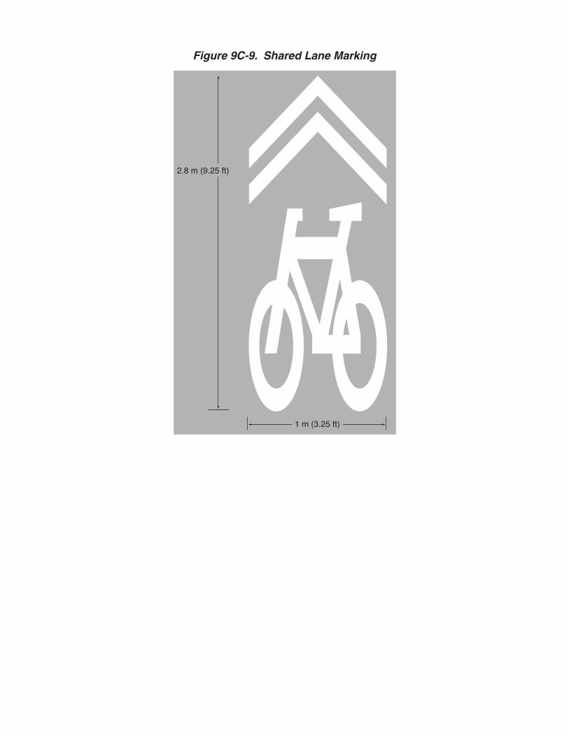
Figure 9C-9. Shared Lane Marking
2.8 m (9.25 ft)
1 m (3.25 ft)

market background


Background: Housing Market Dynamics in Fayette County M & L completed a county-wide housing market analysis in June 2005 that closely studies the housing dynamics in Fayette County. This included market-rate for-sale housing. This analysis provides some context for the proposed housing developments north of Crawford Avenue between N. 3rd Street and the riverfront. The study found the following in the Fayette County market: Market Demand Between 2000 and 2008, the total demand for sales housing is approximately 5,100 units. Most of this demand will be met through the sale of existing homes. However, approximately 1,700 newly constructed units will be needed through 2008. New construction demand is predicted to be approximately 211 units per year. Homeowner housing demand will primarily be generated by the move up, higher income, affordable, and elderly buyer categories. The number of units constructed per year in the county is, at first glance, sufficient to keep pace with homeowner demand.1 However, the types of housing recently constructed are not necessarily meeting all housing demand. Specifically, market rate for-sale housing for households with incomes above $75,000 is not being built in sufficient quantities. Speculative housing development is negligible. And non-traditional for-sale units (patio homes, duplexes, quads, townhouses, condos, etc.) are only just now being constructed in the county. Current construction practices only perpetuate the housing status quo, leaving little room for pent-up demand of non-traditional units to surface. More variety in for-sale housing is crucial to adequately house new residents. The following table provides an analysis of renter and owner housing demand based on existing Census data combined with projections from Claritas.
1 The only quantitative source for current residential construction is building permit data collected by the U.S. Census Bureau from local municipalities and the county. Because of antiquated filing systems and inconsistencies between permit types, local housing practitioners who were part of the study did not believe the building permit data is an accurate depiction of housing construction in Fayette County.

Market r
Demand jobs. Thnew ownvalue is e$225,000existing h Some inrgreater Uunits conproduct t Neighbo In the pasuburbannow resid
rate for-sale
for higher-ee move up a
ner housing dequal to thre0 or more. Whousing stoc
roads have bUniontown arnceived as pato meet this d
orhood revit
st fifty yearsn living. Faydes in its tow
e housing fo
end for-sale hand higher indemand throee times theirWith a mediack and the ty
been made inrea. But addart of the Codemand.
talization ad
s, living pattyette Countywnships. Th
or househo
housing is bencome houseough 2008. Sr annual salaan owner houype of housin
n higher-end ditional unitsonnellsville G
djacent to d
terns nationwy was no exche resulting l
lds with inc
eing generatehold types wSince househary, this incousing value ng new resid
housing, wis are neededGateway-to-G
downtowns
wide shifted eption to thilack of priva
comes abov
ted by an infwill account holds can geome group wof $63,900,
dents’ desire.
ith new unitsd to meet thisGateway Ma
away from uis trend. Moate investmen
ve $75,000
flux of new, for approxim
enerally afforwill demand h
a gap exists .
s under conss demand. Taster Plan co
urban areas aost of the count in the neig
high-payingmately 75% rd a home whomes of between the
struction in thThe market rould provide
and towardsunty’s populghborhoods
g of
whose
e
he ate a
lation of

the county’s cities and boroughs has led to declining housing values, an increased incidence of blight, and rising crime in certain neighborhoods. Revitalization of these areas is necessary for long-term urban stability and viability of the county’s housing stock. Residential areas adjacent to downtowns, such as Connellsville, are suitable targets for revitalization, as their location naturally gives them a higher profile. Preserving the best homes, removing vacant and blighted structures, and introducing new infill residential development is needed to revitalize these neighborhoods. This is a key component of the Connellsville Gateway-to-Gateway Master Plan. Recent Sales Activity Recent sales activity is the best way to understand the dynamics of the housing market. Location, number, and value of sales housing helps to understand the areas of the county that are in demand. The Fayette Board of Realtors operates an independent multiple listing service that tracks sales housing trends. In 2003, 507 units were sold in Fayette County. This was a 28.4% increase over the number of sales in 2000 (395). Sales volume was highest in Uniontown and the Connellsville area. The housing market has slowed in recent years (2007-2009) due to the recession and decline in the overall housing market, and data will most likely show that the rate of sales increase slowed over the past two years.


permeable paving information

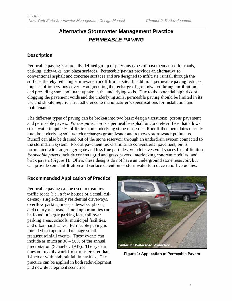
DRAFT New York State Stormwater Management Design Manual Chapter 9: Redevelopment
1
Alternative Stormwater Management Practice PERMEABLE PAVING
Description Permeable paving is a broadly defined group of pervious types of pavements used for roads, parking, sidewalks, and plaza surfaces. Permeable paving provides an alternative to conventional asphalt and concrete surfaces and are designed to infiltrate rainfall through the surface, thereby reducing stormwater runoff from a site. In addition, permeable paving reduces impacts of impervious cover by augmenting the recharge of groundwater through infiltration, and providing some pollutant uptake in the underlying soils. Due to the potential high risk of clogging the pavement voids and the underlying soils, permeable paving should be limited in its use and should require strict adherence to manufacturer’s specifications for installation and maintenance. The different types of paving can be broken into two basic design variations: porous pavement and permeable pavers. Porous pavement is a permeable asphalt or concrete surface that allows stormwater to quickly infiltrate to an underlying stone reservoir. Runoff then percolates directly into the underlying soil, which recharges groundwater and removes stormwater pollutants. Runoff can also be drained out of the stone reservoir through an underdrain system connected to the stormdrain system. Porous pavement looks similar to conventional pavement, but is formulated with larger aggregate and less fine particles, which leaves void spaces for infiltration. Permeable pavers include concrete grid and grass pavers, interlocking concrete modules, and brick pavers (Figure 1). Often, these designs do not have an underground stone reservoir, but can provide some infiltration and surface detention of stormwater to reduce runoff velocities. Recommended Application of Practice Permeable paving can be used to treat low traffic roads (i.e., a few houses or a small cul-de-sac), single-family residential driveways, overflow parking areas, sidewalks, plazas, and courtyard areas. Good opportunities can be found in larger parking lots, spillover parking areas, schools, municipal facilities, and urban hardscapes. Permeable paving is intended to capture and manage small frequent rainfall events. These events can include as much as 30 – 50% of the annual precipitation (Schueler, 1987). The system does not readily work for storms greater than 1-inch or with high rainfall intensities. The practice can be applied in both redevelopment and new development scenarios.
Figure 1: Application of Permeable Pavers
Center for Watershed Protection

DRAFT New York State Stormwater Management Design Manual Chapter 9: Redevelopment
2
Benefits Permeable paving can have many benefits when applied to redevelopment and infill projects in urban centers. The most notable benefits include:
• Groundwater recharge augmentation
• Runoff reduction to ease capacity constraints in storm drain networks
• Effective pollutant treatment for solids, metals, nutrients, and hydrocarbons (see pollutant removal performance, Table 1)
• Aesthetic improvement to otherwise hard urban surfaces (e.g., interlocking permeable
pavers, lattice pavers) Two long-term monitoring studies of porous pavement systems conducted in Rockville, MD, and Prince William, VA, indicated high removal efficiencies for sediments and nutrients (see Table 1). The Rockville study also reported high removals for zinc (99%), lead (98%), and chemical oxygen demand (82%) (Schueler, 1987).
Table 1: Estimated Pollutant Removal Performance of Porous Pavement (Porous Asphalt) (EPA, 1999)
Pollutant Parameter % Removal Total Phosphorus 65 Total Nitrogen 80 – 85 Total Suspended Solids 82 – 95
Feasibility/Limitations Major limitations to this practice are suitability of the site grades, subsoils, drainage characteristics, and groundwater conditions. Proper site selection is an important criteria in reducing the failure rate of this practice. Areas with high amounts of sediment-laden runoff and high traffic volume are likely causes of system failure. High volume parking lots, particularly parking drive aisles, high dust areas, and areas with heavy equipment traffic, are not recommended for this practice. Ownership and maintenance responsibility should also be considered in determining the potential for success. Soil It is important to confirm that local soils are permeable and can support adequate infiltration, since past grading, filling, disturbance, and compaction can greatly alter the original infiltration qualities. The underlying parent soils should have a minimum infiltration rate of 0.5 inches per hour. To maintain effective pollutant removal in the underlying soils organic matter content in the subsoils is important.

DRAFT New York State Stormwater Management Design Manual Chapter 9: Redevelopment
3
Permeable pavers are typically not installed over a gravel chamber, but can be placed on a sand bed to facilitate drainage. Pavers generally provide more surface storage than infiltration capacity, but have the same limitations in terms of clogging. Permeable paving should generally have a drainage time of at least 24 hours. Cold Climate Considerations Permeable paving practices can be used effectively in cold-climate areas, but should not be used where sand or other materials are applied for winter traction since they quickly clog the pavement. Care should be taken when applying salt to permeable pavement, since chlorides can easily migrate into the groundwater. Care should also be taken to select a surface material that can tolerate undulations from frost movements, or to protect pavements from frost damage (Ferguson, 2005).
Land Use Like any stormwater infiltration practice, there is a possibility of groundwater contamination. Therefore, permeable paving should not be used to treat stormwater hotspots, areas where land uses or activities have the potential to generate highly contaminated runoff. These areas can include: commercial nurseries, auto recycling and repair facilities, fleet washing facilities, fueling stations, high-use commercial parking lots, and marinas. Additionally, certain types of permeable pavers, such as block, grid pavers, and gravel, are not ideal for areas that require handicap accessibility.
Sizing and Design Guidance The two types of permeable paving, porous pavement and permeable pavers, have specific sizing guidelines, which are described below. Porous pavement areas are generally designed to accommodate a 1-inch or less design storm. Storms greater than that will either sheet flow off the site, or if not graded properly, will pond on-site. Other design considerations for porous pavement include:
• Soils permeability should be between 0.5 and 3.0 inches per hour. • Clean, washed aggregate must be
specified for the gravel bed/stone reservoir (Figure 2).
• The bottom of the stone reservoir
should not exceed a slope of 5 percent. Ideally it should be completely flat so that the infiltrated runoff will be able to infiltrate through the entire surface. Perforated pipes may be used to distribute runoff through the reservoir evenly.
• Located at least 3 feet above the
seasonally high groundwater table, Figure 2: Porous pavement with a gravel
bed/stone reservoir
http://www.wbdg.org/design/lidtech.php

DRAFT New York State Stormwater Management Design Manual Chapter 9: Redevelopment
4
and at least 100 horizontal feet away from drinking water wells. • As a back-up measure in case of clogging, permeable paving practices can be
designed with a perimeter trench to provide some overflow treatment should the surface clog. The trench may be connected to the stone reservoir
• The contributing drainage area should generally be less than 5 acres, and where
feasible, water should sheet flow onto the practice.
• If stormwater flows onto a permeable paving surface the use of pretreatment practices should be considered so effective pollutant removal can be achieved.
The basic equation for sizing the required porous surface area is as follows:
Ap = Vw / (n x dt ) where: Ap = the required porous pavement surface area [square feet] Vw = the design volume [cubic feet] n = porosity of gravel bed/reservoir (assume 0.4) dt = depth of gravel bed/reservoir (maximum of four feet, and separated by at least three
feet from seasonally high groundwater) [feet]
An example calculation for porous pavement is provided in Table 1.
Table 1: Porous Pavement Simple Sizing Example A porous pavement area is being designed to treat a 20,000 square foot drainage area.
Based on the water quality volume required to treat this area, an assumed gravel bed/reservoir porosity of 0.4, and a gravel bed/reservoir depth of one foot, the following calculations were completed to determine the required porous pavement surface area.
Step 1: Calculate the WQv
WQv = (P) (Rv) (A) / 12
where: P = 90% rainfall number = 0.9 in Rv = 0.05+0.009 (I) = 0.05+0.009(100) = 0.95 I = percentage impervious area draining to site = 100% A = Area Draining to Practice (i.e., treatment area) = 20,000 ft2
WQv = [(0.9)(0.95)(20,000)] / 12 = 1,425 ft3
Step 2: Calculate porous pavement surface area:
Ap = WQv / (n x dt)
where:
n = assumed porosity = 0.4
dt = gravel bed/reservoir depth = 1 ft
Ap = 1,425 ft3 / (0.4 x 1 ft) Ap = 3,562.5ft2 Therefore, to treat the 20,000 square feet, the porous pavement area needed is
approximately 3,560 ft2.

DRAFT New York State Stormwater Management Design Manual Chapter 9: Redevelopment
5
Permeable paver (e.g., interlocking block, concrete gird pavers, etc.) areas are most effective when designed to accommodate small rainfall depths (e.g., less than 1 inch) that fall directly on the paver areas. They are less effective and more prone to clogging when used to also receive runoff from other areas. Unless underlying soils are extremely permeable, larger storms will either sheet flow off the site, or if not graded properly, will pond on the site. For permeable pavers, treatment level will be based on the area covered by permeable pavers multiplied by a “discount factor” (F), that reduces the accounts for the likely effectiveness of the paver based on the application, as described below.
TA = (permeable paver surface area) x (F) where: TA = Treatment Area F = 0.5 or 0.75 (based on high or low usage area designation, respectively) High-usage areas: 0.5 discount factor
This includes sites where permeable pavers are likely to receive fairly high levels of traffic, potential compaction, or where the underlying soils have poor infiltration capacity (e.g., hydrologic soil groups C and D). Examples include multi-family and commercial overflow parking, urban plazas and hardscapes. The assumption is that these areas will be more prone to clogging and compaction of the void spaces and decreased function over time.
Low-usage areas: 0.75 discount factor
This includes low-traffic areas such as single family residential uses, institutional overflow parking with only periodic use, emergency access areas, grass paving systems, and schools, and includes sites with sandy parent materials. The assumption is that these areas will maintain some infiltration capacity and will have minor compaction and clogging issues.
An example calculation for permeable pavers is provided in Table 2.
Environmental/Landscaping Considerations Stringent sediment controls are required during the construction stage, and all adjacent land areas should be stabilized prior to installing permeable paving practices. Where feasible, a grass filter strip is recommended to pre-treat adjacent land areas that drain to porous pavement areas.
Table 2: Permeable Pavers Simple Sizing Example Area covered by permeable pavers = 10,000 ft2 of commercial overflow parking and 2,000 ft2 of emergency access road/path
Solving for treatment area (TA):
TA = 10,000 ft2 x 0.5 + 2,000 ft2 x 0.75 TA = 6,500 ft2

DRAFT New York State Stormwater Management Design Manual Chapter 9: Redevelopment
6
Maintenance The type of permeable paving and the location of the site dictate the required maintenance level and failure rate. Concrete grid pavers and plastic modular blocks require less maintenance because they are not clogged by sediment as easily as porous asphalt and concrete. Areas that receive high volumes of sediment will require frequent maintenance activities, and areas that experience high volumes of vehicular traffic will clog more readily due to soil compaction. Typical maintenance activities for permeable paving are summarized below (Table 3).
Table 3: Typical Maintenance Activities for Permeable Paving (WMI, 1997) Activity Schedule
Ensure that paving area is clean of debris Monthly Ensure that paving dewaters between storms Monthly and after storms >0.5 in. Ensure that the area is clean of sediments Monthly Mow upland and adjacent areas, and seed bare areas As needed Vacuum sweep frequently to keep surface free of sediments Typically 3 to 4 times a year Inspect the surface for deterioration or spalling Annual
When maintenance of permeable paving areas is required, the cause of the maintenance should be understood prior to commencing repairs so unnecessary difficulties and recurring costs can be avoided (Ferguson, 2005). Generally, routine vacuum sweeping and high-pressure washing (with proper disposal of removed material and washwater) can maintain infiltration rates when clogged or crusted material is removed. Signs can also be posted visibly within a permeable paving area to prevent such activities as resurfacing, the use of abrasives, and to restrict truck parking.
Cost Costs for permeable paving are significantly more than traditional pavement (Table 4). However, incorporating savings from not having to build a separate stormwater infrastructure in addition to paving, the overall project costs are often reduced. The estimated annual maintenance cost for a porous pavement parking lot is $200 per acre per year (EPA, 1999). This cost assumes four inspections each year with appropriate jet hosing and vacuum sweeping.
Table 4: Cost Guides for Permeable Pavement System (LID) Paver System Cost Per Square Foot (Installed)
Asphalt $0.50 to $1.00 Porous Concrete $2.00 to $6.50 Grass/gravel pavers $1.50 to $5.75 Interlocking Concrete Paving Blocks $5.00 to $10.00

DRAFT New York State Stormwater Management Design Manual Chapter 9: Redevelopment
7
References Ferguson, B. 2005. Porous Pavements. CRC Press. Low Impact Development Center, Inc. (LID) http://www.lid-stormwater.net/intro/sitemap.htm#permpavers Schueler, T.1987. Controlling Urban Runoff: A Practical manual for Planning and Designing Urban BMPs. Metropolitan Washington Council of Governments. Washington, DC United States Environmental Protection Agency (EPA), “Storm Water Technology Fact Sheet, Porous Pavement”, September 1999. Watershed Management Institute (WMI). 1997. Operation, Maintenance, and Management of Stormwater Management Systems. Prepared for: US EPA Office of Water. Washington, DC.