Embed Size (px)
Citation preview
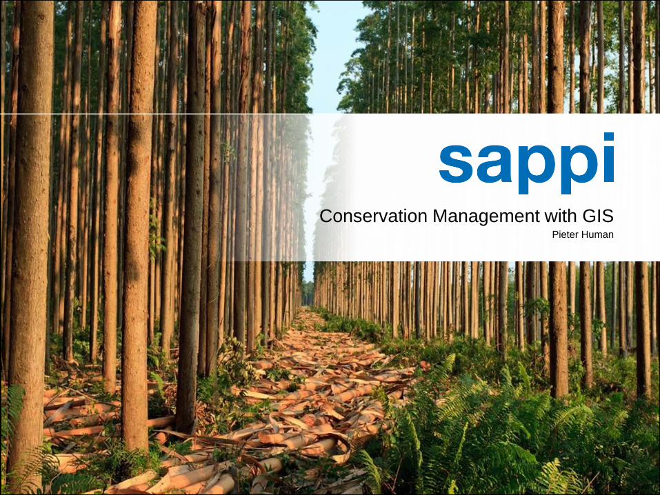
| Conservation Management with GIS | Pieter Human | 18/11/20141
Conservation Management with GISPieter Human
| Conservation Management with GIS | Pieter Human | 18/11/20142
Content• Sappi the Company
• GIS is Green in Sappi
• Land Management
• Data Management
• Data Structure
• Data Distribution
• Environmental Management
• EIA Mapping
• Water/Hydrological Management
• Environmental Incident Monitoring
• Sustainable Forestry Practices
• GPS Camera Game Spotting
• Sappi Important Conservation Areas
• Catchment Management
• Mobile GIS
• Incident logging
• Spatial Analysis
• Timber Flow Modelling
• Transport Optimisation
• Remote sensing
• Disaster Mapping
• Predictive Modelling
• Conclusion
| Conservation Management with GIS | Pieter Human | 18/11/20143
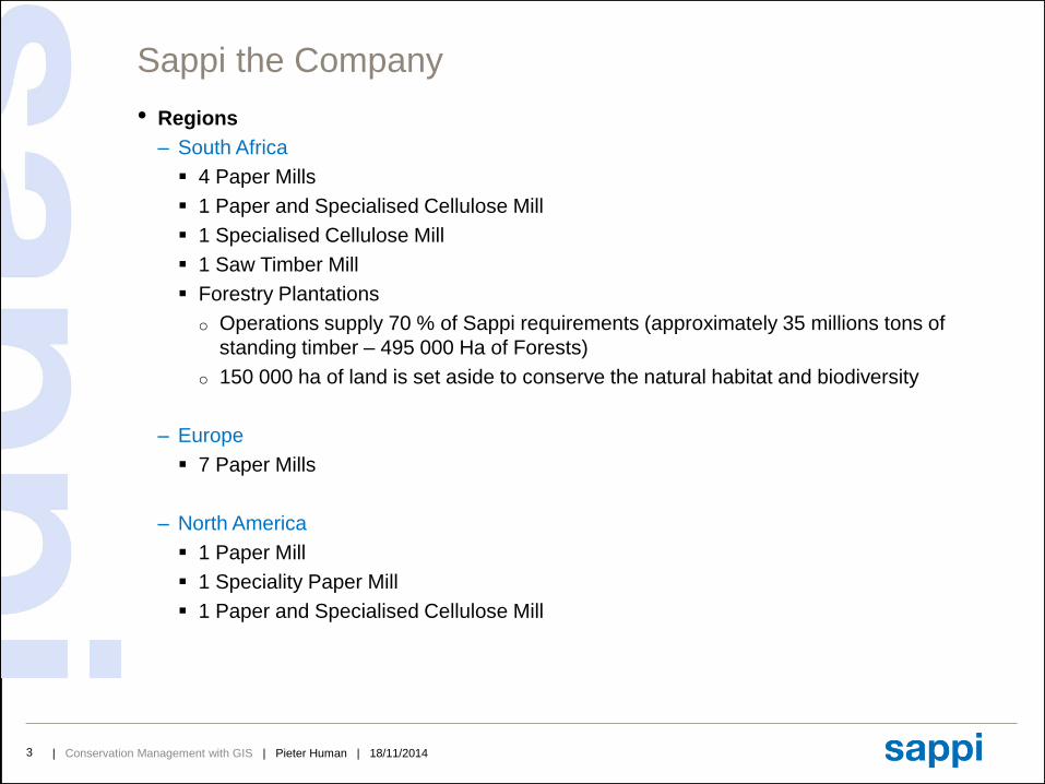
Sappi the Company
• Regions
– South Africa
4 Paper Mills
1 Paper and Specialised Cellulose Mill
1 Specialised Cellulose Mill
1 Saw Timber Mill
Forestry Plantations
o Operations supply 70 % of Sappi requirements (approximately 35 millions tons of
standing timber – 495 000 Ha of Forests)
o 150 000 ha of land is set aside to conserve the natural habitat and biodiversity
– Europe
7 Paper Mills
– North America
1 Paper Mill
1 Speciality Paper Mill
1 Paper and Specialised Cellulose Mill
| Conservation Management with GIS | Pieter Human | 18/11/20144
Content• Sappi the Company
• GIS is Green in Sappi
• Land Management
• Data Management
• Data Structure
• Data Distribution
• Environmental Management
• EIA Mapping
• Water/Hydrological Management
• Environmental Incident Monitoring
• Sustainable Forestry Practices
• GPS Camera Game Spotting
• Sappi Important Conservation Areas
• Catchment Management
• Mobile GIS
• Incident logging
• Spatial Analysis
• Timber Flow Modelling
• Transport Optimisation
• Remote sensing
• Disaster Mapping
• Predictive Modelling
• Conclusion
| Conservation Management with GIS | Pieter Human | 18/11/20145
GIS is Green in Sappi
• Green Management using GIS
– Sappi managed 495 000 hectares of commercial timber plantations
Accurate mapping of all standing timber and natural areas
o Mapping Important Conservation Areas
o Accurate data enable accurate planning and cost effective operations
EIA maps for re-establishment of trees
o Identifying non-conformance areas
o Identifying natural areas
Accurate Delineation
o Cut back planting areas close to streams and wetlands
Reduce transport cost using route optimisation
o Network Analysis
Natural area and erosion management
o Catchment management
o Stream crossing management
o Flow simulation
Effective operational planning
o Identifying correct Timber Extraction Method (terrain, slope, distance to road)
o Harvesting Maps and Analysis
| Conservation Management with GIS | Pieter Human | 18/11/20146
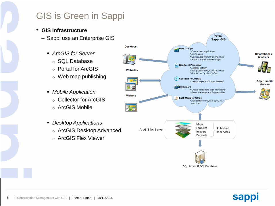
GIS is Green in Sappi
• GIS Infrastructure
– Sappi use an Enterprise GIS
ArcGIS for Server
o SQL Database
o Portal for ArcGIS
o Web map publishing
Mobile Application
o Collector for ArcGIS
o ArcGIS Mobile
Desktop Applications
o ArcGIS Desktop Advanced
o ArcGIS Flex Viewer
SQL Server & SQL Database
Portal
Sappi GIS
User Groups
* Create own application
* Invite users
* Control and monitor user activity
* Publish and share own maps
GeoEvent Processor
* Monitor activity
* Notify users on specific activities
* Administer by cloud admin
Collector for ArcGIS
* Mobile app for IOS and Android
Dashboard
* Create and share data monitoring
* Great warnings and flag activities
ESRI Maps for Office
* Add dynamic maps to pptx, xlsx
and docx
MapsFeaturesImageryDatasets
Published as services
ArcGIS for Server
| Conservation Management with GIS | Pieter Human | 18/11/20147
Content• Sappi the Company
• GIS is Green in Sappi
• Land Management
• Data Management
• Data Structure
• Data Distribution
• Environmental Management
• EIA Mapping
• Water/Hydrological Management
• Environmental Incident Monitoring
• Sustainable Forestry Practices
• GPS Camera Game Spotting
• Sappi Important Conservation Areas
• Catchment Management
• Mobile GIS
• Incident logging
• Spatial Analysis
• Timber Flow Modelling
• Transport Optimisation
• Remote sensing
• Disaster Mapping
• Predictive Modelling
• Conclusion
| Conservation Management with GIS | Pieter Human | 18/11/20148
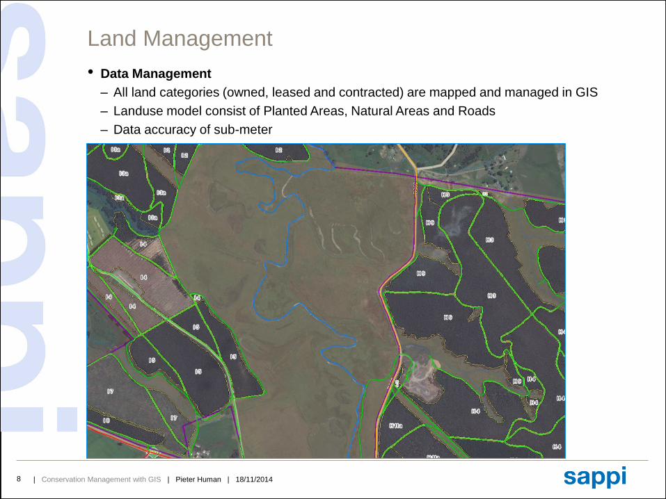
Land Management
• Data Management
– All land categories (owned, leased and contracted) are mapped and managed in GIS
– Landuse model consist of Planted Areas, Natural Areas and Roads
– Data accuracy of sub-meter
| Conservation Management with GIS | Pieter Human | 18/11/20149
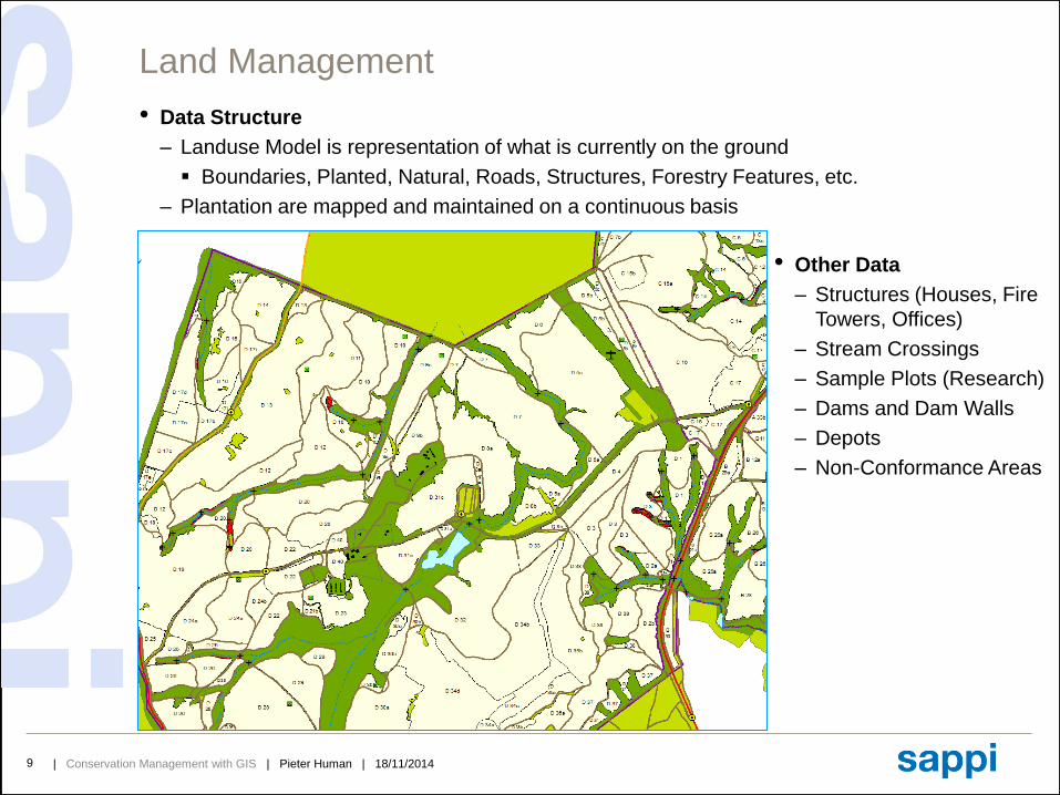
Land Management
• Data Structure
– Landuse Model is representation of what is currently on the ground
Boundaries, Planted, Natural, Roads, Structures, Forestry Features, etc.
– Plantation are mapped and maintained on a continuous basis
• Other Data
– Structures (Houses, Fire
Towers, Offices)
– Stream Crossings
– Sample Plots (Research)
– Dams and Dam Walls
– Depots
– Non-Conformance Areas
| Conservation Management with GIS | Pieter Human | 18/11/201410
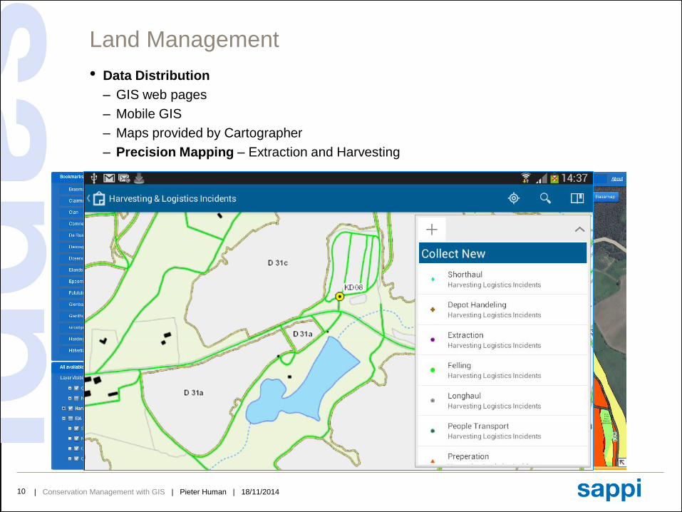
Land Management
• Data Distribution
– GIS web pages
– Mobile GIS
– Maps provided by Cartographer
– Precision Mapping – Extraction and Harvesting
| Conservation Management with GIS | Pieter Human | 18/11/201411
Content• Sappi the Company
• GIS is Green in Sappi
• Land Management
• Data Management
• Data Structure
• Data Distribution
• Environmental Management
• EIA Mapping
• Water/Hydrological Management
• Environmental Incident Monitoring
• Sustainable Forestry Practices
• GPS Camera Game Spotting
• Sappi Important Conservation Areas
• Catchment Management
• Mobile GIS
• Incident logging
• Spatial Analysis
• Timber Flow Modelling
• Transport Optimisation
• Remote sensing
• Disaster mapping
• Predictive modelling
• Conclusion
| Conservation Management with GIS | Pieter Human | 18/11/201412
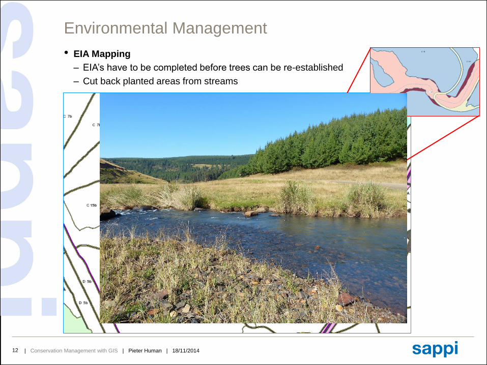
Environmental Management
• EIA Mapping
– EIA’s have to be completed before trees can be re-established
– Cut back planted areas from streams
| Conservation Management with GIS | Pieter Human | 18/11/201413
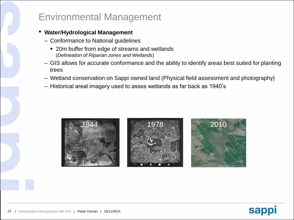
Environmental Management
• Water/Hydrological Management
– Conformance to National guidelines
20m buffer from edge of streams and wetlands(Delineation of Riparian zones and Wetlands)
– GIS allows for accurate conformance and the ability to identify areas best suited for planting
trees
– Wetland conservation on Sappi owned land (Physical field assessment and photography)
– Historical areal imagery used to asses wetlands as far back as 1940’s
1944 1978 2010
| Conservation Management with GIS | Pieter Human | 18/11/201414
Environmental Management
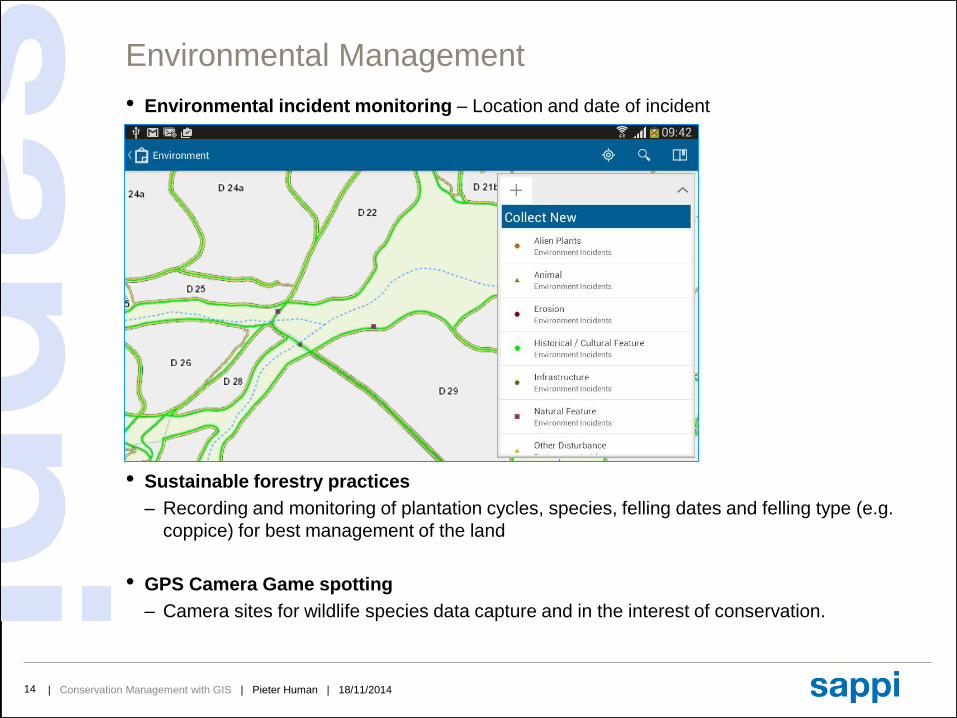
• Environmental incident monitoring – Location and date of incident
• Sustainable forestry practices
– Recording and monitoring of plantation cycles, species, felling dates and felling type (e.g.
coppice) for best management of the land
• GPS Camera Game spotting
– Camera sites for wildlife species data capture and in the interest of conservation.
| Conservation Management with GIS | Pieter Human | 18/11/201415
Environmental Management
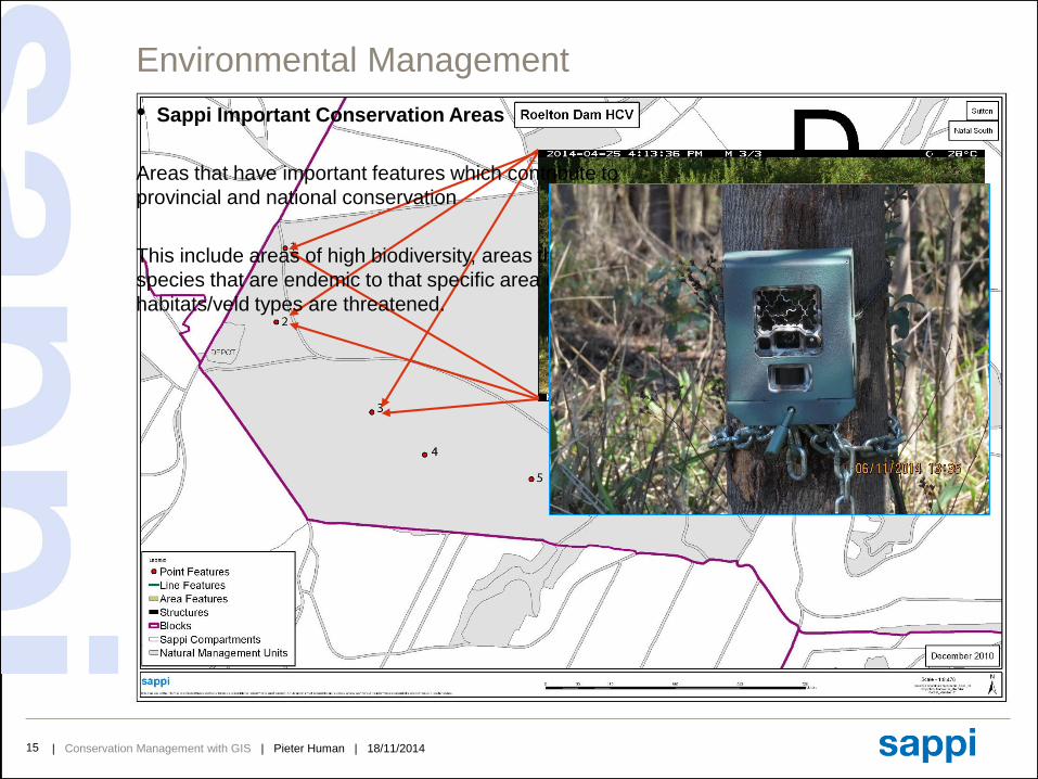
• Sappi Important Conservation Areas
Areas that have important features which contribute to
provincial and national conservation
This include areas of high biodiversity, areas that contain
species that are endemic to that specific area or where
habitats/veld types are threatened.
| Conservation Management with GIS | Pieter Human | 18/11/201416
Content• Sappi the Company
• GIS is Green in Sappi
• Land Management
• Data Management
• Data Structure
• Data Distribution
• Environmental Management
• EIA Mapping
• Water/Hydrological Management
• Environmental Incident Monitoring
• Sustainable Forestry Practices
• GPS Camera Game Spotting
• Sappi Important Conservation Areas
• Catchment Management
• Mobile GIS
• Incident logging
• Spatial Analysis
• Timber Flow Modelling
• Transport Optimisation
• Remote sensing
• Disaster Mapping
• Predictive Modelling
• Conclusion
| Conservation Management with GIS | Pieter Human | 18/11/201417
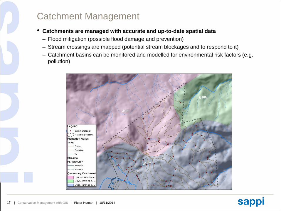
Catchment Management
• Catchments are managed with accurate and up-to-date spatial data
– Flood mitigation (possible flood damage and prevention)
– Stream crossings are mapped (potential stream blockages and to respond to it)
– Catchment basins can be monitored and modelled for environmental risk factors (e.g.
pollution)
| Conservation Management with GIS | Pieter Human | 18/11/201418
Content• Sappi the Company
• GIS is Green in Sappi
• Land Management
• Data Management
• Data Structure
• Data Distribution
• Environmental Management
• EIA Mapping
• Water/Hydrological Management
• Environmental Incident Monitoring
• Sustainable Forestry Practices
• GPS Camera Game spotting
• Sappi Important Conservation Areas
• Catchment Management
• Mobile GIS
• Incident logging
• Spatial Analysis
• Timber Flow Modelling
• Transport Optimisation
• Remote sensing
• Disaster Mapping
• Predictive Modelling
• Conclusion
| Conservation Management with GIS | Pieter Human | 18/11/201419
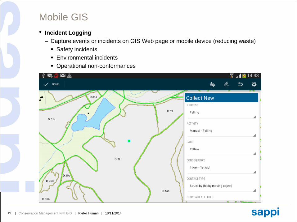
Mobile GIS
• Incident Logging
– Capture events or incidents on GIS Web page or mobile device (reducing waste)
Safety incidents
Environmental incidents
Operational non-conformances
| Conservation Management with GIS | Pieter Human | 18/11/201420
Content• Sappi the Company
• GIS is Green in Sappi
• Land Management
• Data Management
• Data Structure
• Data Distribution
• Environmental Management
• EIA Mapping
• Water/Hydrological Management
• Environmental Incident Monitoring
• Sustainable Forestry Practices
• GPS Camera Game Spotting
• Sappi Important Conservation Areas
• Catchment Management
• Mobile GIS
• Incident logging
• Spatial Analysis
• Timber Flow Modelling
• Transport Optimisation
• Remote sensing
• Disaster Mapping
• Predictive Modelling
• Conclusion

| Conservation Management with GIS | Pieter Human | 18/11/201421
Spatial Analysis
• Timber Flow Modelling
– Shortest distance to depot from each compartment
– Felling extraction analysis using DEM
Provides closest central extraction point to road
Extraction length calculations
Up Hill and Down Hill extraction modelling for efficient planning (type of equipment)
| Conservation Management with GIS | Pieter Human | 18/11/201422
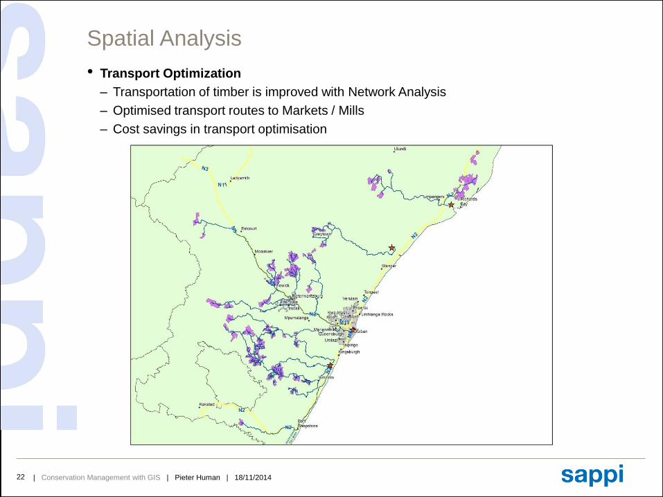
Spatial Analysis
• Transport Optimization
– Transportation of timber is improved with Network Analysis
– Optimised transport routes to Markets / Mills
– Cost savings in transport optimisation
| Conservation Management with GIS | Pieter Human | 18/11/201423
Content• Sappi the Company
• GIS is Green in Sappi
• Land Management
• Data Management
• Data Structure
• Data Distribution
• Environmental Management
• EIA Mapping
• Water/Hydrological Management
• Environmental Incident Monitoring
• Sustainable Forestry Practices
• GPS Camera Game Spotting
• Sappi Important Conservation Areas
• Catchment Management
• Mobile GIS
• Incident logging
• Spatial Analysis
• Timber Flow Modelling
• Transport Optimisation
• Remote sensing
• Disaster Mapping
• Predictive Modelling
• Conclusion

| Conservation Management with GIS | Pieter Human | 18/11/201424
Remote Sensing
• Disaster Mapping
– Post fire analysis
Determine where the fire originated
The area affected by the fire
| Conservation Management with GIS | Pieter Human | 18/11/201425
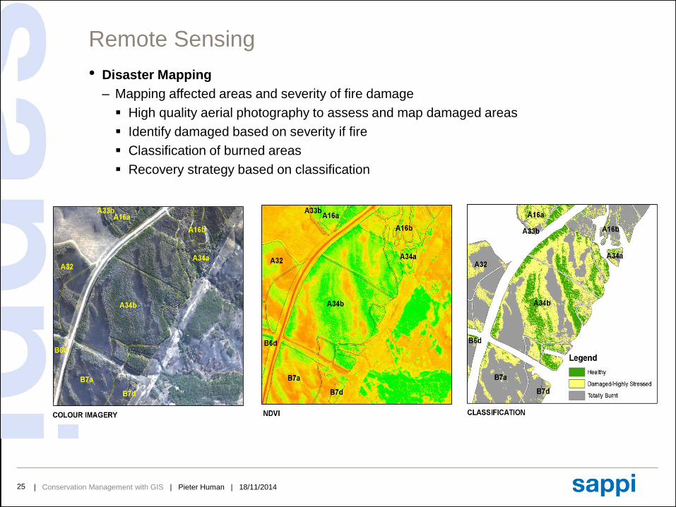
Remote Sensing
• Disaster Mapping
– Mapping affected areas and severity of fire damage
High quality aerial photography to assess and map damaged areas
Identify damaged based on severity if fire
Classification of burned areas
Recovery strategy based on classification
| Conservation Management with GIS | Pieter Human | 18/11/201426
Remote Sensing
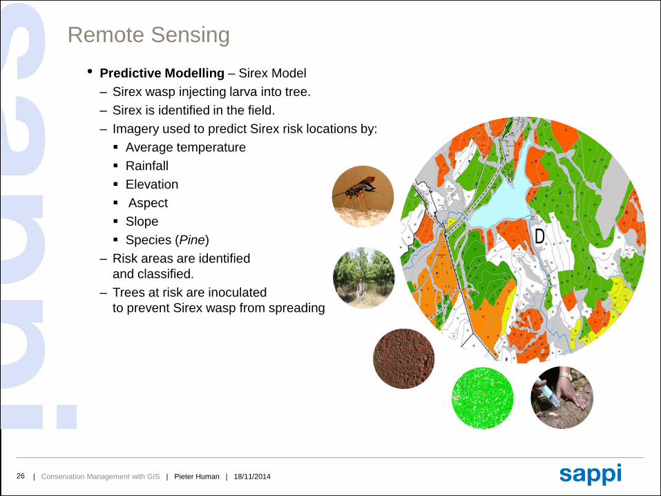
• Predictive Modelling – Sirex Model
– Sirex wasp injecting larva into tree.
– Sirex is identified in the field.
– Imagery used to predict Sirex risk locations by:
Average temperature
Rainfall
Elevation
Aspect
Slope
Species (Pine)
– Risk areas are identified
and classified.
– Trees at risk are inoculated
to prevent Sirex wasp from spreading
| Conservation Management with GIS | Pieter Human | 18/11/201427
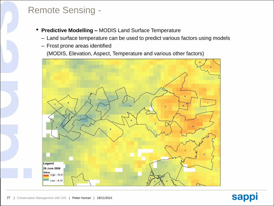
Remote Sensing -
• Predictive Modelling – MODIS Land Surface Temperature
– Land surface temperature can be used to predict various factors using models
– Frost prone areas identified
(MODIS, Elevation, Aspect, Temperature and various other factors)
| Conservation Management with GIS | Pieter Human | 18/11/201428
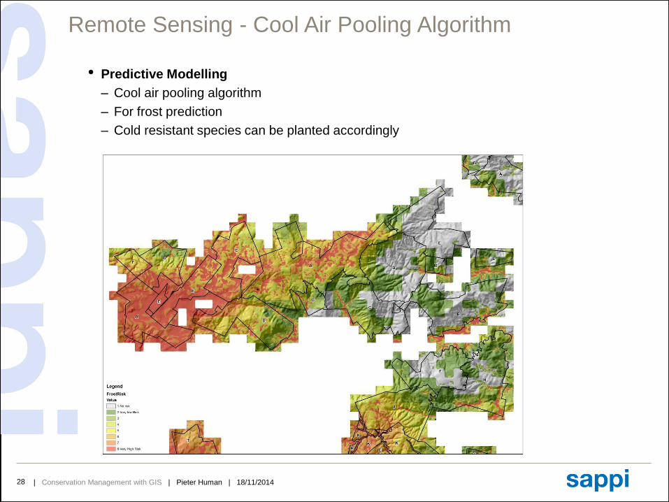
Remote Sensing - Cool Air Pooling Algorithm
• Predictive Modelling
– Cool air pooling algorithm
– For frost prediction
– Cold resistant species can be planted accordingly
| Conservation Management with GIS | Pieter Human | 18/11/201429
Conclusion
• Using GIS, Sappi Strives to
Achieve a high quality of data that is accurate and reliable
Help manage all plantations in a environmentally friendly manner
Maintain and conserve our natural and important conservation areas
Sharing information and knowledge to all Sappi foresters and Contractors
• Final Thought
GIS is the tool to manage accurate and reliable data
BUT MOST IMPORTANTLY
Data is the basis for Good Knowledge
&
Success is how you implement the Knowledge
| Conservation Management with GIS | Pieter Human | 18/11/201430
Thank You