Embed Size (px)
Citation preview

Prepared by the Department of the Environment
Conservation Management Zones of AustraliaSouth Eastern Australia Mixed Temperate Forests Woodlands and Grasslands
Conservation Management Zones of Australia, South Eastern Australia Mixed Temperate Forests Woodlands and Grasslands
AcknowledgementsThis project and its associated products are the result of collaboration between the Department of the Environment’s Biodiversity Conservation Division and the Environmental Resources Information Network (ERIN). Invaluable input, advice and support were provided by staff and leading researchers from across the Department of Environment (DotE), Department of Agriculture (DoA), the Commonwealth Scientific and Industrial Research Organisation (CSIRO) and the academic community. We would particularly like to thank staff within the Wildlife, Heritage and Marine Division, Parks Australia and the Environment Assessment and Compliance Division of DotE; Nyree Stenekes and Robert Kancans (DoA), Sue McIntyre (CSIRO), Richard Hobbs (University of Western Australia), Michael Hutchinson (ANU); David Lindenmayer and Emma Burns (ANU); and Gilly Llewellyn, Martin Taylor and other staff from the World Wildlife Fund for their generosity and advice.
Special thanks to CSIRO researchers Kristen Williams and Simon Ferrier whose modelling of biodiversity patterns underpinned identification of the Conservation Management Zones of Australia.
Image CreditsFront Cover: Jamison Valley, Blue Mountains – Sue Wright, Tourism AustraliaPage 4: Great Otway National Park – James Lauritz, copyright Tourism VictoriaPage 10: Regent Honeyeater (Anthochaera phrygia) – Trent BrowningPage 17: Sunset over Signal Peak, Grampians National Park – Gav OwenPage 25: Genoa Peak, Croajingolong National Park – Paul Sinclair, copyright Tourism VictoriaPage 26: Leadbeater’s Possum (Gymnobelideus leadbeateri) – Dan HarleyPage 28: Giant Gippsland Earthworm (Megacsolides australis) – Alan YenPage 29: Green and Golden Bell Frog (Litoria aurea) – Frank LemckertPage 30: Southern Bent-wing bat (Miniopterus schreibersii bassanii) – Steve BournePage 35: Twelve Apostles, Port Campbell National Park – Paoli Smith, copyright Great Ocean Road MarketingPage 43: Yarra Ranges National Park – Graham Scheer, Magray Images, copyright Tourism VictoriaPage 44: Eucalyptus woodlands with tussock grass, Murray-Sunset National Park – John BakerPage 45: Eucalyptus tall open forests with ferns, herbs, sedges, rushes or wet tussock grasses (Eucalyptus regnans) – Patche99zPage 46: Eucalyptus open forests with a shrubby understorey, Eurobodalla National Park – Murray FaggPage 47: Eucalyptus open forests with a grassy understorey, Nattai National Park – R NicolaiPage 48: Eucalyptus woodlands with a shrubby understorey, Thirlmere Lakes National Park – R NicolaiPage 49: Temperate tussock grasslands Natural Temperate Grassland of the Victorian Volcanic Plain – Department of the EnvironmentBack Cover: Jamison Valley, Blue Mountains – Sue Wright, Tourism Australia
© Commonwealth of Australia, 2015.
The Conservation Management Zones of Australia profile is licensed by the Commonwealth of Australia for use under a Creative Commons By Attribution 3.0 Australia licence with the exception of the Coat of Arms of the Commonwealth of Australia, the logo of the agency responsible for publishing the report, content supplied by third parties, and any images depicting people.
For licence conditions see here.

Conservation Management Zones of Australia, South Eastern Australia Mixed Temperate Forests Woodlands and Grasslands
Contents
Acknowledgement of Traditional Owners and Country ����������������������������������������������2
Introduction ���������������������������������������������������������������������������������������������������������������������������������2
Zone at a glance �������������������������������������������������������������������������������������������������������������������������3
Population characteristics �������������������������������������������������������������������������������������������������������6
Employment, volunteering and incomes ��������������������������������������������������������������������������9
Agriculture, Natural Resource Management practices and sources of NRM advice ��������������������������������������������������������������������������������������������������11
Land tenure, land use, Native Title and Local Government Areas ������������������������� 13
Zone vegetation characteristics����������������������������������������������������������������������������������������� 16
Ramsar and Nationally Important Wetlands ������������������������������������������������������������������ 18
World and National Heritage ���������������������������������������������������������������������������������������������� 22
Major National Reserve System properties �������������������������������������������������������������������� 23
EPBC Act (1999) threatened ecological communities ������������������������������������������������� 24
EPBC Act (1999) threatened species ��������������������������������������������������������������������������������� 26
EPBC Act (1999) migratory species ������������������������������������������������������������������������������������ 34
Threatened endemic species ���������������������������������������������������������������������������������������������� 36
Invasive species ����������������������������������������������������������������������������������������������������������������������� 40
Vegetation profiles and management recommendations ��������������������������������������� 43
2 / Conservation Management Zones of Australia, South Eastern Australia Mixed Temperate Forests Woodlands and Grasslands
The Australian Government acknowledges Australia’s Traditional Owners and pays respect to Elders past and present of our nation’s Aboriginal and Torres Strait Islander communities� We honour the deep spiritual, cultural and customary connections of Traditional Owners to the Australian landscape, including Australia’s waterways, land and sea country�
Introduction The 23 Conservation Management Zones of Australia are geographic areas, classified according to their ecological and threat characteristics. The zones are also aligned with the Interim Biogeographic Regionalisation of Australia.
The Conservation Management Zones provide a way of understanding Australia’s natural environment that will assist in long-term conservation planning and help the Australian Government to better design, deliver and report on Natural Resource Management (NRM) investments, including ensuring alignment of national NRM priorities with local action.
The Conservation Management Zones also provide a filter through which to make national environmental and socio-economic data more accessible and comprehensible, and a framework for gathering on-ground knowledge and expertise about the environment. This will improve information flow to the Australian Government about regional NRM requirements, best practice management, emerging NRM issues and knowledge gaps.
The Conservation Management Zones do not represent any change to existing administrative boundaries or governance structures, but aim to support the NRM and wider community to cooperatively manage environmental assets across boundaries, where they share common threats, ecological characteristics and stakeholders.
Each Conservation Management Zone profile contains a standard suite of nationally available ecological and socio-economic information. We hope that this information will enable Australians of all ages and backgrounds to engage with, understand and appreciate Australian landscapes, and support all Australians to manage our natural resources more effectively.
The profile information provides an indicative, high-level stock-take of the environmental and socio-economic landscape and it is not intended to be comprehensive. It should also be noted that, at present, the profiles contain only limited information on aquatic ecosystems, coastal assets and Indigenous land management practices. In future, consultation and comprehensive literature reviews will enable us to provide more complete information.
Acknowledgement of Traditional Owners and Country

3 / Conservation Management Zones of Australia, South Eastern Australia Mixed Temperate Forests Woodlands and Grasslands
Zone at a glance
Area of zone: 22,984,191 hectares
% of Australia:
2.98%35.55 people per square kilometre
Population density:
Zone population characteristics
0
2,000,000
4,000,000
6,000,000
8,000,000
10,000,000
8,420,754
Tota
l
Engl
ish a
s a
seco
nd
lang
uage
I ndi
geno
us
Ove
r 65
Yout
h (1
5–24
)
Num
ber o
f peo
ple
Zone employment characteristics
95.5%
4.5%
UnemployedEmployed
Source: Based on Australian Bureau of Statistics data

4 / Conservation Management Zones of Australia, South Eastern Australia Mixed Temperate Forests Woodlands and Grasslands
Major cities and towns Population
Albury – Wodonga 84,982
Ballarat 95,021
Bathurst 34,124
Bendigo 88,668
Canberra-Queenbeyan 411,609
Cowra-Young-Yass 22,204
Geelong 179,042
Goulburn 21,460
Melbourne 4,246,345
Melton 45,688
NSW South Coast 39,178
Orange 34,996
Pakenham 32,916
Sale 12,764
Sunbury 33,045
Traralgon-Morwell 40,602
Wagga Wagga 53,832
Warranambool 33,024
Warragul-Drouin 31,280
Natural Resource Management (NRM) regions
Murray Local Land Services (LLS) NSWRiverina LLS NSWSouth East LLS NSWCorangamite Catchment Management Authority (CMA) VIC
East Gippsland CMA VICGlenelg-Hopkins CMA VICGoulburn-Broken CMA VICNorth Central CMA VICNorth East CMA VICPort Philip and Westernport CMA VICWest Gippsland CMA VIC
Top five agricultural commodities Value (millions)
Dairy $1,888
Beef $1,461
Lamb $956
Vegetables for consumption $728
Wool $713Total value of agricultural commodities (including other commodities not listed here)
$8,714
Climate characteristics*
Mean annual temperature 12.7 Celsius
Mean Maximum of the Hottest Month 26.2 Celsius
Mean Minimum of the Coldest Month 1.8 Celsius
Mean Annual Rainfall 797.9 mm
Dominant rainfall season Winter
* The figures are interpolated 75-year means (1921 to 1995) representing the period prior to the onset of rapid climatic warming. Cited in: Williams KJ, Belbin L, Austin MP, Stein J, Ferrier S (2012) Which environmental variables should I use in my biodiversity model? International Journal of Geographic Information Sciences 26(11), 2009–2047. (Data derived from Australian Climate surfaces version 2.1 for the ANUCLIM-BIOCLIM package).
For future climate projections please refer to: http://www.climatechangeinaustralia.gov.au/
Source: Based on Australian Bureau of Statistics data

5 / Conservation Management Zones of Australia, South Eastern Australia Mixed Temperate Forests Woodlands and Grasslands
Native Title area
6%
94%
Other areaNative Title area
National Reserve System area
14%
86%
Other areaNRS area
Native vegetation clearance level
51%49%
Uncleared (ha)Cleared (ha)
Number of threatened species by class
224
32
18
1212
Fish
FrogsBirdsPlants Mammals
Insects
Reptiles
Sharks Other Crustaceans
24
3
113
Status of EPBC Act listed threatened species, communities and migratory species
0.0 34.8 69.6 104.4 139.2 174.0
174
120
73
25
15Threatened ecologicalcommunities
Migratory species
Critically endangered species
2Conservation dependent
Endangered species
Vulnerable species
Source: Based on data from the National Native Title Register; Collaborative Australian Protected Area Database (CAPAD); National Vegetation Information System (NVIS); Species’ Profile and Threats Database (SPRAT).

6 / Conservation Management Zones of Australia, South Eastern Australia Mixed Temperate Forests Woodlands and Grasslands
Population
Population by age group
19%
14%
32%
22%
65 years and over40–64 years
15–24 years0–14 years 25–39 years
13%
Indigenous population by age group
40%
21%
3%
19%
17%
65 years and over40–64 years
15–24 years0–14 years 25–39 years
Farmer and farm managers by age group
15%
3%
27%
55%
65 years and over40–64 years
25–39 years15–24 years
Gender of farmers and farm managers
26,238
11,276
FemaleMale
Source: Based on Australian Bureau of Statistics data
Population characteristics
7 / Conservation Management Zones of Australia, South Eastern Australia Mixed Temperate Forests Woodlands and Grasslands
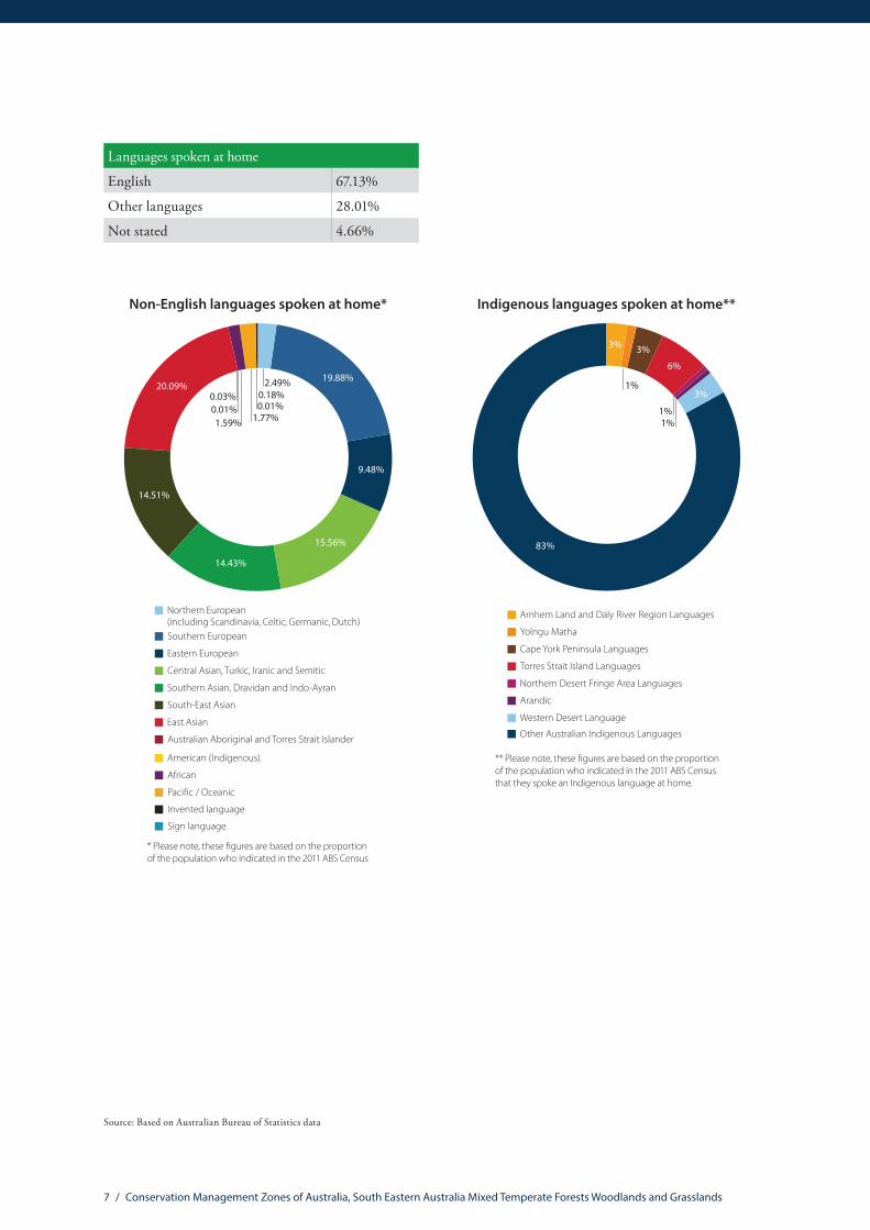
Languages spoken at home
English 67.13%
Other languages 28.01%
Not stated 4.66%
Non-English languages spoken at home*
Northern European (including Scandinavia, Celtic, Germanic, Dutch)Southern European
Eastern European
Central Asian, Turkic, Iranic and Semitic
Southern Asian, Dravidan and Indo-Ayran
South-East Asian
East Asian
Australian Aboriginal and Torres Strait Islander
American (Indigenous)
African
Paci�c / Oceanic
Invented language
9.48%
15.56%
20.09% 2.49%
0.01%1.77%
0.03% 0.18%
Sign language
* Please note, these �gures are based on the proportion of the population who indicated in the 2011 ABS Census that they spoke a language other than English at home.
19.88%
14.51%
14.43%
0.01%1.59%
Indigenous languages spoken at home**
83%
Arnhem Land and Daly River Region Languages
Yolngu Matha
Cape York Peninsula Languages
Torres Strait Island Languages
Northern Desert Fringe Area Languages
Arandic
Western Desert Language
** Please note, these �gures are based on the proportion of the population who indicated in the 2011 ABS Census that they spoke an Indigenous language at home.
Other Australian Indigenous Languages
1%
1%1%
6%
3%
3%
3%
Source: Based on Australian Bureau of Statistics data

8 / Conservation Management Zones of Australia, South Eastern Australia Mixed Temperate Forests Woodlands and Grasslands
Education
0%
5%
10%
15%
20%
25%
30%
35%
40%
45%
65 years and over40–64 years
25–39 years15–24 years
Highest level of educational attainment – total population
Inad
equa
tely
des
crib
ed/N
ot st
ated
No
Educ
atio
nal A
ttai
nmen
t
Scho
ol Y
ears
10
or b
elow
Scho
ol Y
ears
11
and
12
Cert
i�ca
te L
evel
Bach
elor
Deg
ree/
Adva
nced
Dip
lom
a an
d D
iplo
ma
Post
grad
uate
Deg
ree/
Gra
duat
eD
iplo
ma
& G
radu
ate
Cert
i�ca
te
Highest level of educational attainment – Indigenous community
0%
5%
10%
15%
20%
25%
30%
35%
40%
45%
Inad
equa
tely
des
crib
ed/N
ot st
ated
No
Educ
atio
nal A
ttai
nmen
t
Scho
ol Y
ears
10
or b
elow
Scho
ol Y
ears
11
and
12
Cert
i�ca
te L
evel
Bach
elor
Deg
ree/
Adva
nced
Dip
lom
a an
d D
iplo
ma
Post
grad
uate
Deg
ree/
Gra
duat
eD
iplo
ma
& G
radu
ate
Cert
i�ca
te
65 years and over40–64 years
25–39 years15–24 years
0%
5%
10%
15%
20%
25%
30%
35%
40%
45%
50%
65 years and over40–64 years
25–39 years15–24 years
Highest level of educational attainment – farmers and farm managers
Inad
equa
tely
des
crib
ed/N
ot st
ated
No
Educ
atio
nal A
ttai
nmen
t
Scho
ol Y
ears
10
or b
elow
Scho
ol Y
ears
11
and
12
Cert
i�ca
te L
evel
Bach
elor
Deg
ree/
Adva
nced
Dip
lom
a an
d D
iplo
ma
Post
grad
uate
Deg
ree/
Gra
duat
eD
iplo
ma
& G
radu
ate
Cert
i�ca
te
0
100,000
200,000
300,000
400,000
500,000
Post-school quali�cation types*
15–2
4 ye
ars o
ld
25–3
9 ye
ars o
ld
40–6
4 ye
ars o
ld
65 y
ears
an
d ab
ove
Natural and Physical Sciences
Agriculture, Environmental and Related Studies
Health and education
Architecture, building, society and culture and creative arts
Information Technology, Management and Commerce and service industries
* Please note, this table omits quali�cations of mixed �eld, quali�cations that are not adequately described, and information relating to census respondents who have not stated their quali�cation or are not applicable (i.e. Not of age to have post-school quali�cation).
Source: Based on Australian Bureau of Statistics data
9 / Conservation Management Zones of Australia, South Eastern Australia Mixed Temperate Forests Woodlands and Grasslands
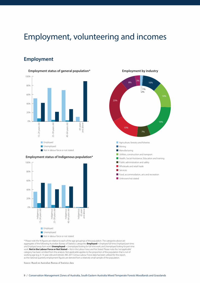
Employment
0%
20%
40%
60%
80%
100%
Employment status of general population*
65 y
ears
and
abov
e
15–2
4 ye
ars o
ld
40–6
4 ye
ars o
ld
25–3
9 ye
ars o
ld
Employed
Unemployed
Not in labour force or not stated
* Please note the % �gures are relative to each of the age groupings of the population. The categories above are aggregates of the following Australian Bureau of Statistics categories: Employed = Employed full-time; Employed part-time; and Employed away from work. Unemployed = Unemployed looking for full-time work; and Unemployed looking for part-time work. Not in the Labour Force or Not Stated = Not in the Labour Force; and Not Stated. Please note the ‘not applicable’ category has been omitted from the analysis. Not applicable applies to the proportion of the population that is not of working age (e.g. 0–15 year olds and retired). ABS 2011 Census Labour Force data has been utilised for this report, as the national quarterly employment �gures are derived from a relatively small sample of the population.
Employment by industry
Agriculture, forestry and sheries
Mining
Manufacturing
Utilities, construction and transport
Health, Social Assistance, Education and training
Public administration and safety
Wholesale and retail trade
Services
Food, accommodation, arts and recreation
Unknown/not stated
10%
19%
7%
15%
23%
8%3%
14%
1%2%
0%
20%
40%
60%
80%
100%
Employment status of general population*
65 y
ears
and
abov
e
15–2
4 ye
ars o
ld
40–6
4 ye
ars o
ld
25–3
9 ye
ars o
ld
Employed
Unemployed
Not in labour force or not stated
* Please note the % �gures are relative to each of the age groupings of the population. The categories above are aggregates of the following Australian Bureau of Statistics categories: Employed = Employed full-time; Employed part-time; and Employed away from work. Unemployed = Unemployed looking for full-time work; and Unemployed looking for part-time work. Not in the Labour Force or Not Stated = Not in the Labour Force; and Not Stated. Please note the ‘not applicable’ category has been omitted from the analysis. Not applicable applies to the proportion of the population that is not of working age (e.g. 0–15 year olds and retired). ABS 2011 Census Labour Force data has been utilised for this report, as the national quarterly employment �gures are derived from a relatively small sample of the population.
0%
20%
40%
60%
80%
100%
Employment status of Indigenous population*
Indi
geno
us65
yea
rsan
d ab
ove
Indi
geno
us15
–24
year
s old
Indi
geno
us40
–64
year
s old
Indi
geno
us25
–39
year
s old
Employed
Unemployed
Not in labour force or not stated
Source: Based on Australian Bureau of Statistics data
Employment, volunteering and incomes

10 / Conservation Management Zones of Australia, South Eastern Australia Mixed Temperate Forests Woodlands and Grasslands
Volunteering
0%
10%
20%
30%
40%
50%
60%
70%
80%
Volunteering rates
15–2
4 ye
ars o
ld
25–3
9 ye
ars o
ld
40–6
4 ye
ars o
ld
65 y
ears
an
d ab
ove
Not a volunteer
Volunteer
Not stated or not applicable
Income
Total household income (% of households)*
20.0%
47.7%
10.3%
6.1%
15.8%
Over $104,000
Under $20,800
Not Stated/Partially Stated
$20,800–64,999 $65,000–$103,999
* Please note these �gures have been derived from the ABS Equivalised Total Household Income (HIED)Census 2011 data. ABS data categories have been aggregated for the purposes of this report. For more information see: http://www.abs.gov.au/websitedbs/censushome.nsf/home/statementsdwellinghied?opendocument&navpos=430
In the 2011–12 �nancial year, persons who earned $67,500 or less were eligible for Low Income Tax O�set. Human Services applied the following de�nitions of “low income” as eligibility criteria for the Low Income Supplement in the 2012–13 �nancial year: Income below $30,000 for singles, $45,000 combined for couples, or $60,000 combined for couples or singles with a dependent child.
Source: Based on Australian Bureau of Statistics data

11 / Conservation Management Zones of Australia, South Eastern Australia Mixed Temperate Forests Woodlands and Grasslands
Agricultural commodity values
Value of agricultural commodities^
$0
$200
$400
$600
$800
$1,000
$1,200
$1,400
$1,600
$1,800
$2,000
Oth
er b
road
acre
cro
ps
Nut
s
Frui
t
Oils
eeds
Legu
me
for g
rain
Hay
Cere
als f
or g
rain
Eggs
Woo
l
Beef
Lam
b
Pork
Dai
ry
Vege
tabl
es fo
r see
d
Vege
tabl
es fo
r con
sum
ptio
n
Nur
serie
s and
cut
�ow
ers
Mill
ions
^ Data obtained from the Australian Bureau of Statistics Value of Agricultural Commodities Produced. The value estimates in this publication are derived by the multiplication of price and quantity estimates of agricultural commodities. Price information is estimated based on the average unit value of a given commodity realised in the market place. For more information please refer to: http://www.abs.gov.au/AUSSTATS/[email protected]/Lookup/7503.0Explanatory%20Notes12010-11?OpenDocument
Source: Based on Australian Bureau of Statistics data
Agriculture, Natural Resource Management practices and sources of NRM adviceAustralian farmers manage over 60% of the Australian continent and shoulder much of the burden of responsibility for maintaining and protecting Australia’s natural resource wealth. The information contained in this profile aims to assist the wider community, non-governmental organisations and government agencies to support Australia’s key environmental custodians.
Number of people employed in agriculture, �shing, forestry and downstream industries
50,748
103,890
204
79
83Forestry industry, including
production, logging, sawmillingand downstream wood and
paper product manufacturing
Fishing industry, includingproduction and downstream
seafood processingand wholesaling
Agriculture downstreamindustries, including services,
food and beverage
Agriculture industries(production)
34,388
1,657

12 / Conservation Management Zones of Australia, South Eastern Australia Mixed Temperate Forests Woodlands and Grasslands
Natural Resource Management practices and sources of NRM advice
0%
10%
20%
30%
40%
50%
60%
70%
80%
90%
100%
Feral animal control*(% of agricultural holdings)
No
man
agem
ent
of fe
ral a
nim
als
Oth
er (u
nspe
ci�e
d)fe
ral a
nim
al c
ontr
ol
Fera
l goa
ts
0%
1%
2%
3%
4%
5%
6%
7%
8%
Native vegetation protection and regeneration*(% of agricultural holdings)
Oth
er
Stop
ping
mec
hani
cal
or c
hem
ical
des
truc
tion
Redu
cing
gra
zing
pre
ssur
e
Man
agin
g w
eeds
Fenc
ing
o�/e
xclu
ding
stoc
k
Sought advice when adopting native vegetation management**
83.28%
16.72%
NoYes
Sources of advice**^
Yes
No
Yes
No
Yes
No
Yes
No
Yes
No
Yes
No
Yes
No
Priv
ate
cons
ulta
nt o
rag
ribus
ines
s age
nt
CMA/
NRM
regi
onem
ploy
ed fa
cilit
ator
Rese
arch
and
Dev
elop
men
t Cor
pora
tion
Gov
ernm
ent
exte
nsio
n o�
cer
Peer
s or n
eigh
bour
s
Farm
er g
roup
Land
care
or f
arm
erpr
oduc
tion
grou
p
** The sample for the Drivers of Practice Change 2012 survey consisted of a random subsample of 1228 broadacre farm managers from the Australian Agricultural and Grazing Industries Survey (AAGIS) frame. The data has been aligned to Conservation Management Zones from ABS Statistical Area 2 units. For this reason, the figures presented here are indicative only.
^ This chart indicates the sources of advice utilised for native vegetation management from respondents who identified they sought advice.
For more information please refer to http://www.daff.gov.au/SiteCollectionDocuments/forestry/domestic-forestry/prep-for-future/drivers-practice-change.pdf
* Data obtained from the Australian Bureau of Statistics (ABS) 2012 Land Management Practices Survey (LaMPS) 2012. LaMPS collected land practices information from approximately 50,000 farm businesses across Australia. The data has been aligned to Conservation Management Zones from ABS Statistical Area 2 units and Australian Agricultural Environment units. The % figures presented here are indicative only. For more information on LaMPS please refer to: http://www.abs.gov.au/ausstats/[email protected]/mf/4630.0

13 / Conservation Management Zones of Australia, South Eastern Australia Mixed Temperate Forests Woodlands and Grasslands
Land tenure, land use, Native Title and Local Government Areas
Land tenure
Crown Land – Private – Leased
Crown Land – Public
Crown Land – Public – Leased
Crown Land – Unknown – Leased
Freehold – Unknown
No Data/Unknown
0.25%30.07%
37.57%
32.11%
0.001%0.001%
Land use
Grazing Modi�ed Pastures
Conservation and Natural Environments
Industry, Residential, Services and Mining
Cropping and Horticulture
Production Forestry (native vegetation)
Plantation Forestry
Production from Irrigated Agriculture and Plantations
Water (natural)
Other
0.5%0.4%0.1%
46%
32%
6%
7%
2% 2%
Source: Land tenure data based on Environmental Resources Information Network (ERIN) categorisation of Public Sector Mapping Authority (PSMA) State Tenure 2012; Land use mapping based on Australian Collaborative Land Use and Management Program (ACLUMP) 2012. For more information on Australian land use and management information and classification please refer to: http://www.daff.gov.au/ABARES/aclump/Pages/Default.aspx
Indigenous Land Councils
New South Wales Aboriginal Land Council: www.alc.org.au
Native Title Services Victoria: http://www.ntsv.com.au

14 / Conservation Management Zones of Australia, South Eastern Australia Mixed Temperate Forests Woodlands and Grasslands
Local Government Areas
Albury City Council NSW
Auburn City Council NSW
Bankstown City Council NSW
Bathurst Regional Council NSW
Bega Valley Shire Council NSW
Blacktown City Council NSW
Blayney Shire Council NSW
Blue Mountains City Council NSW
Bombala Council NSW
Boorowa Council NSW
Cabonne Shire Council NSW
Camden Council NSW
Campbelltown City Council NSW
Cooma-Monaro Council NSW
Cowra Shire Council NSW
Dubbo City Council NSW
Eurobodalla Shire Council NSW
Forbes Shire Council NSW
Goulburn Mulwaree Council NSW
Greater Hume Shire Council NSW
Gundagai Shire Council NSW
Harden Shire Council NSW
Hawkesbury City Council NSW
Junee Shire Council NSW
Lithgow City Council NSW
Lockhart Shire Council NSW
Mid-Western Regional Council NSW
Local Government Areas
Narromine Shire Council NSW
Oberon Council NSW
Orange City Council NSW
Palerang Council NSW
Parkes Shire Council NSW
Penrith City Council NSW
Queanbeyan City Council NSW
Shoalhaven City Council NSW
Snowy River Shire Council NSW
Tumbarumba Shire Council NSW
Tumut Council NSW
Upper Lachlan Shire Council NSW
Wagga Wagga City Council NSW
Warrumbungle Shire Council NSW
Weddin Shire Council NSW
Wellington Council NSW
Wingecarribee Shire Council NSW
Wollondilly Shire Council NSW
Yass Valley Council NSW
Young Shire Council NSW
Alpine Shire VIC
Ararat Rural City VIC
Ballarat City VIC
Banyule City VIC
Bass Coast Shire VIC
Baw Baw Shire VIC
Bayside City VIC
Native Title and Traditional Owners
Traditional Owners Registered Native Title Body Corporate Hectares % of zone
Gunai/Kurnai People Gunaikurnai Land & Waters Aboriginal Corporation RNTBC 1,159,376 5.04
Gunditjmara People Gunditj Mirring Traditional Owners Aboriginal Corporation RNTBC 63,296 0.28
Wotjobaluk People Barengi Gadjin Land Council Aboriginal Corporation RNTBC 36,062 0.16
Gunditjmara and Eastern Maar peoples
Gunditj Mirring Traditional Owners Aboriginal Corporation RNTBC, Eastern Maar Aboriginal Corporation RNTBC
3,915 0.02
Source: The Native Title Tribunal Register, October 2013. For more information please refer to: http://www.nntt.gov.au/Pages/Searchportal.aspx

15 / Conservation Management Zones of Australia, South Eastern Australia Mixed Temperate Forests Woodlands and Grasslands
Local Government Areas
Benalla Rural City VIC
Boroondara City VIC
Brimbank City VIC
Buloke Shire VIC
Campaspe Shire VIC
Cardinia Shire VIC
Casey City VIC
Central Goldfields Shire VIC
Colac Otway Shire VIC
Corangamite Shire VIC
Darebin City VIC
East Gippsland Shire VIC
Frankston City VICFrench-Elizabeth-Sandstone Islands (Uninc) VIC
Gabo Island (Unincorporated) VIC
Glen Eira City VIC
Glenelg Shire VIC
Golden Plains Shire VIC
Greater Bendigo City VIC
Greater Dandenong City VIC
Greater Geelong City VIC
Greater Shepparton City VIC
Hepburn Shire VIC
Hobsons Bay City VIC
Horsham Rural City VIC
Hume City VIC
Indigo Shire VIC
Kingston City VIC
Knox City VIC
Latrobe City VIC
Loddon Shire VIC
Macedon Ranges Shire VIC
Manningham City VIC
Mansfield Shire VIC
Maribyrnong City VIC
Maroondah City VIC
Local Government Areas
Melbourne City VIC
Melton City VIC
Mitchell Shire VIC
Moira Shire VIC
Monash City VIC
Moonee Valley City VIC
Moorabool Shire VIC
Moreland City VIC
Mornington Peninsula Shire VIC
Mount Alexander Shire VICMount Baw Baw Alpine Resort (Unincorporated) VIC
Mount Buller Alpine Resort (Unincorporated) VIC
Mount Stirling Alpine Resort (Unincorporated) VIC
Moyne Shire VIC
Murrindindi Shire VIC
Nillumbik Shire VIC
Northern Grampians Shire VIC
Port Phillip City VIC
Pyrenees Shire VIC
Queenscliffe Borough VIC
South Gippsland Shire VIC
Southern Grampians Shire VIC
Stonnington City VIC
Strathbogie Shire VIC
Surf Coast Shire VIC
Towong Shire VIC
Wangaratta Rural City VIC
Warrnambool City VIC
Wellington Shire VIC
West Wimmera Shire VIC
Whitehorse City VIC
Whittlesea City VIC
Wodonga City VIC
Wyndham City VIC
Yarra City VIC
Yarra Ranges Shire VIC
16 / Conservation Management Zones of Australia, South Eastern Australia Mixed Temperate Forests Woodlands and Grasslands
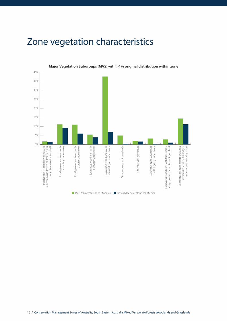
Zone vegetation characteristics
Major Vegetation Subgroups (MVS) with >1% original distribution within zone
Euca
lypt
us w
oodl
ands
with
a tu
ssoc
k gr
ass u
nder
stor
ey
Tem
pera
te tu
ssoc
k gr
assla
nds
Euca
lypt
us w
oodl
ands
with
a sh
rubb
y un
ders
tore
y
Euca
lypt
us w
oodl
ands
with
fern
s, he
rbs,
sedg
es, r
ushe
s or w
et tu
ssoc
k gr
assla
nd
Euca
lypt
us o
pen
fore
sts w
itha
shru
bby
unde
rsto
rey
Oth
er tu
ssoc
k gr
assla
nds
Euca
lypt
us o
pen
woo
dlan
dsw
ith a
gra
ssy
unde
rsto
rey
Euca
lypt
us o
pen
fore
sts w
itha
gras
sy u
nder
stor
ey
Euca
lypt
us ta
ll op
en fo
rest
s and
ope
nfo
rest
s with
fern
s, he
rbs,
sedg
es,
rush
es o
r wet
tuss
ock
gras
ses
Euca
lypt
us (+
/- ta
ll) o
pen
fore
st w
itha
dens
e br
oad-
leav
ed a
nd/o
r tre
e-fe
rnun
ders
tore
y (w
et sc
lero
phyl
l)
0%
5%
10%
15%
20%
25%
30%
35%
40%
Present day percentage of CMZ areaPre 1750 percentage of CMZ area

17 / Conservation Management Zones of Australia, South Eastern Australia Mixed Temperate Forests Woodlands and Grasslands
The National Vegetation Information System (NVIS) framework is a nationally consistent vegetation classification system based on vegetation data collected by states and territories. It provides information on the extent and distribution of vegetation types across the Australian landscape.
Two products are used to provide the Zone Vegetation Characteristics graph. A modelled pre-European vegetation distribution (pre-1750), and extant (current extent) vegetation, which is based on contemporary vegetation mapping. The information presented here relates to Major Vegetation Subgroups (MVSs). There are 85 MVS types across Australia, describing the structure and floristic composition of dominant and secondary vegetation stratums (e.g. canopy and mid-storey species). Major Vegetation Subgroups only reflect the dominant vegetation type occurring in an area from a mix of vegetation types. Less-dominant vegetation groups which may also be present are therefore not represented.
It is important to note that the vegetation information is indicative only, as state and territory mapping in Australia is of variable resolution and scale. However, this data is the best available nationally consistent information on vegetation, and the dataset continues to evolve and increase in accuracy.
Analysing this information at Conservation Management Zone, rather than national level provides greater discrimination for decision makers, as clearance levels of vegetation types are not uniform across Australia. For example, eucalypt woodlands with a tussock grass understory is a vegetation type found across Australia. In the Brigalow Woodlands Conservation Management Zone, eucalypt open woodlands with a tussock grass understory originally covered approximately 36% of the zone, but today it only covers only 14.5 % of the zone (58.7% of this vegetation community has been cleared in the Brigalow). In the Northern Australia Tropical Savannah zone, this vegetation type originally occupied 19.6% of the zone. Today, it occupies approximately 19.4% of the zone (only 2.3% of this vegetation type has been cleared). It should be noted that this data only provides an indication of change in extent, and not vegetation condition.
For more information on the National Vegetation Information System (NVIS) please refer to: http://www.environment.gov.au/topics/science-and-research/databases-and-maps/national-vegetation-information-system

18 / Conservation Management Zones of Australia, South Eastern Australia Mixed Temperate Forests Woodlands and Grasslands
Nationally Important Wetlands Jurisdiction Hectares Criteria
Anderson Inlet VIC 131.00 2, 3, 4
Bald Hills State Wildlife Reserve VIC 13.00 1, 3, 5
Banongill Network VIC 87.80 1
Bega Swamp NSW 21.20 1, 6
Bemm, Goolengook, Arte and Errinundra Rivers VIC 3,862.10 1, 2, 3, 4
Bendora Reservoir ACT 70.90 5
Benedore River VIC 3,523.50 1, 2, 3, 4, 5
Bethungra Dam Reserve NSW 0.10 3
Big Badja Swamp NSW 85.70 1, 5, 6
Big River VIC 1,874.70 2, 3, 4, 5, 6
Billabong Flora and Fauna Reserve VIC 20.70 1, 5
Bondi Lake NSW 26.80 1, 6
Bosses/Nebbor Swamp VIC 258.30 1, 3
Boyd Plateau Bogs NSW 0.10 1, 2, 5
Central Highlands Peatlands VIC 10.50 1
Clyde River Estuary NSW 1,069.30 1, 3, 5
Cobden-Terang Volcanic Craters VIC 568.60 1
Coila Creek Delta NSW 3.90 1, 4
Coopers Swamp NSW 0.10 1, 3
Coree Flats NSW 0.10 1
Corner Inlet VIC 9,054.40 1, 3, 4, 5
Cotter Flats ACT 0.10 1
Cullendulla Creek and Embayment NSW 13.50 1, 6
Cundare Pool/Lake Martin VIC 3,741.20 1, 3, 4
Ramsar and Nationally Important Wetlands
Ramsar wetlands Jurisdiction Hectares
Corner Inlet VIC 14,801 Edithvale-Seaford Wetlands – Seaford VIC 261
Gippsland Lakes VIC 61,025Port Phillip Bay (Western Shoreline) and Bellarine Peninsula – Corio Bay
VIC 17,164
Western District Lakes VIC 32,683Western Port VIC 2,975
For more information on Ramsar please refer to: http://www.environment.gov.au/topics/water/water-our-environment/wetlands/ramsar-convention-wetlands

19 / Conservation Management Zones of Australia, South Eastern Australia Mixed Temperate Forests Woodlands and Grasslands
Nationally Important Wetlands Jurisdiction Hectares Criteria
Deep Water Morass VIC 56.20 1, 3, 5
Dergholm (Youpayang) Wetlands VIC 8.20 1, 3
Durras Lake NSW 275.20 1, 6
Edithvale-Seaford Wetlands VIC 131.70 1, 3, 6
Ewing’s Marsh (Morass) VIC 1,335.90 1, 5
Genoa River VIC 1,034.40 1, 3, 4, 5, 6
Horse Park Wetland ACT 0.10 1, 3, 6
Howqua River VIC 2,029.20 1, 2, 3, 4, 5, 6
Jack Smith Lake State Game Reserve VIC 2,859.50 1, 3, 5
Jacksons Bog NSW 0.10 1, 6
Jerrabomberra Wetlands ACT 0.10 3, 6
Kooraweera Lakes VIC 367.80 1, 2, 4, 5
Kosciusko Alpine Fens, Bogs and Lakes NSW 296.20 1, 4, 5
Lake Bathurst NSW 989.00 1, 3, 6
Lake Beeac VIC 658.50 1, 3, 4, 5
Lake Bookaar VIC 552.70 1, 3, 5
Lake Bunga VIC 16.00 1, 5
Lake Buninjon VIC 285.60 1, 3, 5
Lake Colongulac VIC 1,563.40 1, 3
Lake Condah VIC 81.80 1, 6
Lake Connewarre State Wildlife Reserve VIC 3,596.20 1, 2, 3, 4, 5
Lake Corangamite VIC 24,423.60 1, 2, 3, 4, 5
Lake Cundare VIC 294.80 1, 3, 4
Lake Dartmouth VIC 5,927.90 6
Lake George NSW 12,850.70 1, 3, 5, 6
Lake Gnarpurt VIC 2,595.90 1, 2, 3
Lake Hume VIC 9,973.00 1, 2, 6
Lake King Wetlands VIC 16,137.40 1, 2, 3, 4, 5
Lake Linlithgow Wetlands VIC 1,392.30 1, 3, 4, 5
Lake Milangil VIC 250.10 1, 2, 3, 5
Lake Muirhead VIC 659.70 1, 3, 4
Lake Murdeduke VIC 1,864.20 1, 2, 3
Lake Tali Karng VIC 11.50 1, 3, 6
Lake Terangpom VIC 197.70 1, 2, 3
Lake Tyers VIC 1,282.80 1, 3, 5
Lake Victoria Wetlands VIC 9,256.90 1, 2, 3, 5, 6
Lake Wellington Wetlands VIC 27,546.50 1, 2, 3, 4, 5, 6
Lake Wendouree VIC 223.80 1, 3, 6

20 / Conservation Management Zones of Australia, South Eastern Australia Mixed Temperate Forests Woodlands and Grasslands
Nationally Important Wetlands Jurisdiction Hectares Criteria
Lerderderg River VIC 5,192.60 3, 4, 5, 6
Lindenow Wildlife Sanctuary VIC 30.80 1, 3
Lower Goulburn River Floodplain VIC 0.80 1, 2
Lower Lough Calvert & Lake Thurrumbong VIC 1,066.50 1, 2
Lower Merri River Wetlands VIC 145.60 1, 2, 3, 5
Lower Snowy River Wetlands System VIC 2,860.00 1, 2, 3, 5
Macleod Morass VIC 508.80 1, 3
Mallacoota Inlet Wetlands VIC 995.40 1, 3, 5, 6
Merimbula Lake NSW 376.40 1
Merin Merin Swamp VIC 215.00 1, 3
Micalong Swamp NSW 123.90 1, 6
Middle Lough Calvert VIC 554.40 1, 2, 3, 4
Mitta Mitta River VIC 2,319.90 3, 4, 5, 6
Monaro Lakes NSW 376.80 1, 2, 5
Moruya River Estuary Saltmarshes NSW 76.20 1, 2
Mount William Swamp VIC 627.20 1, 3, 4
Mud Islands VIC 5.40 1, 2, 3, 4, 5
Mundi-Selkirk Wetlands VIC 3.40 1, 2, 3
Nadgee Lake and tributary wetlands NSW 269.40 1, 2, 5
Nargal Lake NSW 11.10 1, 3
Nelson Lagoon NSW 95.30 1
Nerrin Nerrin Wetlands VIC 523.80 1, 3, 4, 5
Nunnock Swamp NSW 1.50 1, 2, 3, 5
Packers Swamp NSW 0.10 1, 2
Pambula Estuarine Wetlands NSW 330.80 2, 3, 5, 6
Point Cook & Laverton Saltworks VIC 517.60 1, 2, 3, 4, 5
Powlett River Mouth VIC 18.60 6
Princetown Wetlands VIC 152.70 1, 2, 3
Red Rock Lakes & The Basins VIC 234.10 1, 6
Rooty Break Swamp VIC 0.90 1
Russells Swamp VIC 92.00 3
Shallow Inlet Marine & Coastal Park VIC 1,920.50 1, 3, 4
Snowy River VIC 46,500.30 1, 3, 4, 5, 6
Stonyford-Bungador Wetlands VIC 63.40 1
Suggan Buggan and Berrima Rivers VIC 1,253.20 2, 3, 4
Swan Bay & Swan Island VIC 412.70 1, 2, 3, 4, 5
Sydenham Inlet Wetlands VIC 1,369.60 1, 3, 5
Tambo River (Lower Reaches) East Swamps VIC 100.20 3

21 / Conservation Management Zones of Australia, South Eastern Australia Mixed Temperate Forests Woodlands and Grasslands
Nationally Important Wetlands Jurisdiction Hectares Criteria
Tamboon Inlet Wetlands VIC 798.00 1, 3, 5
Tea Tree Swamp (Delegate River) VIC 176.10 1, 3, 5
Thurra River VIC 2,961.80 1, 3, 5
Tower Hill VIC 305.50 1, 3, 6
Tuross River Estuary NSW 1,095.10 1, 2, 5
Upper Buchan River VIC 856.40 1, 2, 3, 4, 5
Upper Cotter River ACT 0.10 1, 6
Upper Lough Calvert VIC 848.70 1, 2, 3
Upper Naas Creek ACT 0.10 1
Waldrons Swamp NSW 71.70 1, 3
Wallaga Lake NSW 822.90 5, 6
Wallagoot Lagoon (Wallagoot Lake) NSW 377.50 5, 6
Werribee-Avalon Area VIC 2,743.50 1, 3, 4, 5
Western Port VIC 29,150.00 1, 2, 3, 4, 5, 6
Widderin Swamps VIC 296.70 1, 3, 4, 6
Wongungarra River VIC 304.60 1, 3, 4, 5
Wonnangatta River VIC 3,699.00 1, 2, 3, 4, 5, 6
Woorndoo-Hopkins Wetlands VIC 692.50 1, 2
Yambuk Wetlands VIC 364.90 1, 2, 3, 5
Yarra River VIC 1,412.10 1, 3, 4
Werribee-Avalon Area VIC 2,743.52 1, 3, 4, 5
Western Port VIC 29,150.05 1, 2, 3, 4, 5, 6
Widderin Swamps VIC 296.74 1, 3, 4, 6
Wongungarra River VIC 304.56 1, 3, 4, 5
Wonnangatta River VIC 3,699.04 1, 2, 3, 4, 5, 6
Woorndoo-Hopkins Wetlands VIC 692.53 1, 2
Yambuk Wetlands VIC 364.93 1, 2, 3, 5
Yarra River VIC 1,412.10 1, 3, 4
Nationally important wetlands are defined according to the following criteria:1. It is a good example of a wetland type occurring within a biogeographic region in Australia.2. It is a wetland which plays an important ecological or hydrological role in the natural functioning of a major wetland system/complex.3. It is a wetland which is important as the habitat for animal taxa at a vulnerable stage in their life cycles, or provides a refuge when
adverse conditions such as drought prevail.4. The wetland supports 1% or more of the national populations of any native plant or animal taxa.5. The wetland supports native plant or animal taxa or communities which are considered endangered or vulnerable at the national level.6. The wetland is of outstanding historical or cultural significance.Please note, the above are a subset of all the Nationally Important Wetlands found within the Zone. For more information on Nationally Important Wetlands please see: http://www.environment.gov.au/resource/directory-important-wetlands-australia-third-edition

22 / Conservation Management Zones of Australia, South Eastern Australia Mixed Temperate Forests Woodlands and Grasslands
Please refer to the Australian Heritage Database for detailed information on listing criteria for these heritage values: http://www.environment.gov.au/topics/heritage/publications-and-resources/australian-heritage-database
For more information on Australia’s world and national heritage please refer to: http://www.environment.gov.au/topics/heritage/about-australias-heritage
World and National Heritage
Heritage values World or National Heritage type Jurisdiction Hectares % of zone
The Greater Blue Mountains Area World and National Natural NSW 244,493.99 1.06
Royal Exhibition Building and Carlton Gardens World Heritage Cultural VIC 25.453798 0.00
Australian Alps National Parks and Reserves National Natural NSW 928,777.434007 4.04
Grampians National Park (Gariwerd) National Natural VIC 167,179.82 0.73
Budj Bim National Heritage Landscape – Tyrendarra Area
National Indigenous VIC 8,154.59 0.04
Castlemaine Diggings National Heritage Park National Historic VIC 7,535.67 0.03
Great Ocean Road and Scenic Environs National Historic VIC 4,308.35 0.02
Point Nepean Defence Sites and Quarantine Station Area
National Historic VIC 529.48 0.00
Point Cook Air Base National Historic VIC 256.33 0.00Flemington Racecourse National Historic VIC 127.8 0.00Coranderrk National Indigenous VIC 81.65 0.00Old Government House and the Government Domain
National Historic NSW 49.52 0.00
Royal Exhibition Building National Historic Place National Historic VIC 25.45 0.00
Australian War Memorial and the Memorial Parade National Historic ACT 25.49 0.00
Mount William Stone Hatchet Quarry National Indigenous VIC 17.96 0.00
High Court – National Gallery Precinct National Historic ACT 14.15 0.00
Flora Fossil Site – Yea National Natural VIC 12.57 0.00Glenrowan Heritage Precinct National Historic VIC 8.01 0.00
Eureka Stockade Gardens National Historic VIC 7.83 0.00Melbourne Cricket Ground National Historic VIC 7.69 0.00Sidney Myer Music Bowl National Historic VIC 6.25 0.00Rippon Lea House and Garden National Historic VIC 5.58 0.00
Newman College National Historic VIC 4.02 0.00Old Parliament House and Curtilage National Historic ACT 3.6 0.00
High Court of Australia (former) National Historic VIC 0.25 0.00
ICI Building (former) National Historic VIC 0.23 0.00Australian Academy of Science Building National Historic ACT 0.16 0.00
23 / Conservation Management Zones of Australia, South Eastern Australia Mixed Temperate Forests Woodlands and Grasslands
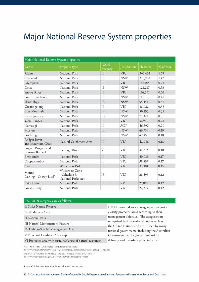
Major National Reserve System properties
Major National Reserve System properties
Name Property type IUCN category Jurisdiction Hectares % of zone
Alpine National Park II VIC 363,402 1.58Kosciuszko National Park II NSW 325,990 1.42Grampians National Park II VIC 167,185 0.73Deua National Park IB NSW 121,217 0.53Snowy River National Park II VIC 114,691 0.50South East Forest National Park II NSW 111,013 0.48Wadbilliga National Park IB NSW 95,455 0.42Croajingolong National Park II VIC 88,022 0.38Blue Mountains National Park II NSW 80,493 0.35Kanangra-Boyd National Park IB NSW 71,321 0.31Yarra Ranges National Park II VIC 57,960 0.25Namadgi National Park II ACT 46,392 0.20Morton National Park II NSW 43,754 0.19Goobang National Park II NSW 42,455 0.18Rodger River and Mountain Creek Natural Catchment Area II VIC 42,288 0.18
Suggan Buggan and Berrima Rivers H.R. Heritage River V VIC 41,793 0.18
Errinundra National Park II VIC 40,089 0.17Coopracambra National Park II VIC 38,497 0.17Avon Wilderness Park IB VIC 35,318 0.15
Mount Darling – Snowy Bluff
Wilderness Zone – Schedule 5, National Parks Act
IB VIC 28,595 0.12
Lake Eildon National Park II VIC 27,861 0.12Great Otway National Park II VIC 27,239 0.12
The IUCN categories are as follows:
Ia Strict Nature Reserve IUCN protected area management categories classify protected areas according to their management objectives. The categories are recognised by international bodies such as the United Nations and are utilised by many national governments, including the Australian Government, as the global standard for defining and recording protected areas.
Ib Wilderness Area
II National Park
III Natural Monument or Feature
IV Habitat/Species Management Area
V Protected Landscape/ Seascape
VI Protected area with sustainable use of natural resources
Please refer to the IUCN website for further explanation: http://www.iucn.org/about/work/programmes/gpap_home/gpap_quality/gpap_pacategories/
For more information on Australia’s National Reserve System please refer to: http://www.environment.gov.au/topics/land/national-reserve-system
Source: Collaborative Australian Protected Area Database 2012.

24 / Conservation Management Zones of Australia, South Eastern Australia Mixed Temperate Forests Woodlands and Grasslands
EPBC Act (1999) threatened ecological communitiesThreatened ecological communities
Name Listing status % of total distribution* % of zone**Silurian Limestone Pomaderris Shrubland of the South East Corner and Australian Alps Bioregions
Endangered 100 0.001
Lowland Grassy Woodland in the South East Corner Bioregion
Critically Endangered 100 0.058
Natural Temperate Grassland of the Victorian Volcanic Plain
Critically Endangered 99.90 6.705
Grassy Eucalypt Woodland of the Victorian Volcanic Plain
Critically Endangered 99.90 10.349
Gippsland Red Gum (Eucalyptus tereticornis subsp. mediana) Grassy Woodland and Associated Native Grassland
Critically Endangered 99.90 2.005
Natural Temperate Grassland of the Southern Tablelands of NSW and the Australian Capital Territory
Endangered 99.50 0.047
Upland Basalt Eucalypt Forests of the Sydney Basin Bioregion Endangered 88.20 0.295
Upland Wetlands of the New England Tablelands and the Monaro Plateau Endangered 54.40 0.007
White Box-Yellow Box-Blakely’s Red Gum Grassy Woodland and Derived Native Grassland
Critically Endangered 42.00 4.243
Seasonal Herbaceous Wetlands (Freshwater) of the Temperate Lowland Plains
Critically Endangered 38.40 0.067
Grey Box (Eucalyptus microcarpa) Grassy Woodlands and Derived Native Grasslands of South-eastern Australia
Endangered 18.30 1.382
Subtropical and Temperate Coastal Saltmarsh Vulnerable 8.80 0.081
Alpine Sphagnum Bogs and Associated Fens Endangered 2.90 0.064Littoral Rainforest and Coastal Vine Thickets of Eastern Australia
Critically Endangered 1.20 0.002
Weeping Myall Woodlands Endangered 0.00 0.002
* % of the total national distribution describes the proportion of the total national distribution of the Threatened Ecological Community that is found within the zone.
** % of the total zone area describes the proportion of the zone that the Threatened Ecological Community is likely or known to occur in.

25 / Conservation Management Zones of Australia, South Eastern Australia Mixed Temperate Forests Woodlands and Grasslands
It should be noted that the identification of any given Threatened Ecological Community above does not imply that the Threatened Ecological Community (TEC) is found uniformly across the Conservation Management Zone. Rather, the % of the TEC’s total distribution (*) within the zone is an indication of its importance to that zone in terms of conservation efforts. The % of the zone (**) indicates how rare, or difficult the ecological community may be to find within the zone.
The threatened ecological communities above are listed under The Environment Protection and Biodiversity Conservation Act 1999 (EPBC Act), which is the Australian Government’s principal environmental legislation. For more information, please refer to http://www.environment.gov.au/biodiversity/threatened/communities

26 / Conservation Management Zones of Australia, South Eastern Australia Mixed Temperate Forests Woodlands and Grasslands
EPBC Act (1999) threatened species
Threatened mammals
Common name Scientific name Status % of total distribution*
% of zone**
Eastern Barred Bandicoot (Mainland) Perameles gunnii unnamed subsp. Endangered 100 0.01Long-footed Potoroo Potorous longipes Endangered 97.63 3.89Konoom, Smoky Mouse Pseudomys fumeus Endangered 79.56 11.64Leadbeater’s Possum Gymnobelideus leadbeateri Endangered 72.19 0.45Southern Brown Bandicoot (Eastern) Isoodon obesulus obesulus Endangered 51.49 8.56Dayang, Heath Rat Pseudomys shortridgei Vulnerable 38.45 1.66Long-nosed Potoroo (SE mainland) Potorous tridactylus tridactylus Vulnerable 36.23 6.51
Southern Bent-wing Bat Miniopterus schreibersii bassanii Critically Endangered 35.43 2.08
Grey-headed Flying-fox Pteropus poliocephalus Vulnerable 27.95 20.99Spot-tailed Quoll, Spotted-tail Quoll, Tiger Quoll (southeastern mainland population)
Dasyurus maculatus maculatus (SE mainland population) Endangered 27.11 20.65
Brush-tailed Rock-wallaby Petrogale penicillata Vulnerable 16.18 2.90New Holland Mouse, Pookila Pseudomys novaehollandiae Vulnerable 15.64 6.47Koala (combined populations of Queensland, New South Wales and the Australian Capital Territory)
Phascolarctos cinereus (combined populations of Qld, NSW and the ACT)
Vulnerable 9.87 17.94
Large-eared Pied Bat, Large Pied Bat Chalinolobus dwyeri Vulnerable 8.26 9.54South-eastern Long-eared Bat Nyctophilus corbeni Vulnerable 5.73 8.01Mountain Pygmy-possum Burramys parvus Endangered 1.06 0.00Southern Right Whale Eubalaena australis Endangered n/a n/aHumpback Whale Megaptera novaeangliae Vulnerable n/a n/a

27 / Conservation Management Zones of Australia, South Eastern Australia Mixed Temperate Forests Woodlands and Grasslands
Threatened birds
Common name Scientific name Status % of total distribution*
% of zone**
Helmeted Honeyeater, Yellow-tufted Honeyeater (Helmeted)
Lichenostomus melanops cassidix Endangered 100 0.004
Regent Honeyeater Anthochaera phrygia Endangered 37.44 38.914
Swift Parrot Lathamus discolor Endangered 34.29 26.771
Superb Parrot Polytelis swainsonii Vulnerable 26.78 21.081
Gould’s Petrel Pterodroma leucoptera leucoptera Endangered 25.05 0.000
Australasian Bittern Botaurus poiciloptilus Endangered 20.8 33.540Australian Fairy Tern Sternula nereis nereis Vulnerable 17.69 4.437
Eastern Bristlebird Dasyornis brachypterus Endangered 14.64 3.066
Red-tailed Black-Cockatoo (south-eastern) Calyptorhynchus banksii graptogyne Endangered 9.87 0.613
Orange-bellied Parrot Neophema chrysogaster Critically Endangered 6.68 1.844
Australian Painted Snipe Rostratula australis Endangered 1.57 1.332
Plains-wanderer Pedionomus torquatus Vulnerable 1.47 0.450
Malleefowl Leipoa ocellata Vulnerable 0.43 2.014
Salvin’s Albatross Thalassarche cauta salvini Vulnerable 0.04 0.420
Shy Albatross, Tasmanian Shy Albatross Thalassarche cauta cauta Vulnerable 0.03 0.420
Northern Royal Albatross Diomedea epomophora sanfordi Endangered 0.03 0.420
Gibson’s Albatross Diomedea exulans gibsoni Vulnerable 0.02 0.224
White-capped Albatross Thalassarche cauta steadi Vulnerable 0.02 0.420
Campbell Albatross Thalassarche melanophris impavida Vulnerable 0.02 0.208
Chatham Albatross Thalassarche eremita Endangered 0.02 0.116
Southern Royal Albatross Diomedea epomophora epomophora Vulnerable 0.02 0.420
Antipodean Albatross Diomedea exulans antipodensis Vulnerable 0.01 0.235
Wandering Albatross Diomedea exulans (sensu lato) Vulnerable 0.01 0.235
Buller’s Albatross, Pacific Albatross Thalassarche bulleri Vulnerable 0 0.000
Tristan Albatross Diomedea exulans exulans Endangered n/a n/a
Soft-plumaged Petrel Pterodroma mollis Vulnerable n/a n/a
Black-browed Albatross Thalassarche melanophris Vulnerable n/a n/a
Grey-headed Albatross Thalassarche chrysostoma Endangered n/a n/a
Kermadec Petrel (western) Pterodroma neglecta neglecta Vulnerable n/a n/a
Buller’s Albatross, Pacific Albatross Thalassarche bulleri Vulnerable n/a n/a
Blue Petrel Halobaena caerulea Vulnerable n/a n/a
Southern Giant-Petrel Macronectes giganteus Endangered n/a n/a
Northern Giant-Petrel Macronectes halli Vulnerable n/a n/a
* % of total distribution describes the proportion of the total national distribution of the threatened species that is found within the zone.
** % of zone describes the proportion of the zone that the threatened species is likely or known to occur in.
The % of zone indicates how rare, or difficult the species may be to find within the zone.
28 / Conservation Management Zones of Australia, South Eastern Australia Mixed Temperate Forests Woodlands and Grasslands
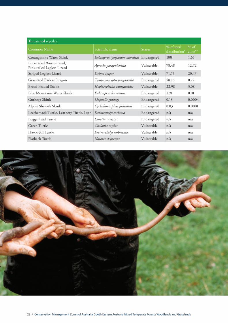
Threatened reptiles
Common Name Scientific name Status % of total distribution*
% of zone**
Corangamite Water Skink Eulamprus tympanum marnieae Endangered 100 1.65Pink-tailed Worm-lizard, Pink-tailed Legless Lizard Aprasia parapulchella Vulnerable 78.48 12.72
Striped Legless Lizard Delma impar Vulnerable 71.53 20.47
Grassland Earless Dragon Tympanocryptis pinguicolla Endangered 58.16 0.72
Broad-headed Snake Hoplocephalus bungaroides Vulnerable 22.98 3.08
Blue Mountains Water Skink Eulamprus leuraensis Endangered 1.91 0.01
Guthega Skink Liopholis guthega Endangered 0.18 0.0004
Alpine She-oak Skink Cyclodomorphus praealtus Endangered 0.03 0.0001
Leatherback Turtle, Leathery Turtle, Luth Dermochelys coriacea Endangered n/a n/a
Loggerhead Turtle Caretta caretta Endangered n/a n/a
Green Turtle Chelonia mydas Vulnerable n/a n/a
Hawksbill Turtle Eretmochelys imbricata Vulnerable n/a n/a
Flatback Turtle Natator depressus Vulnerable n/a n/a

29 / Conservation Management Zones of Australia, South Eastern Australia Mixed Temperate Forests Woodlands and Grasslands
Other threatened fauna
Common name Scientific name Status % of total distribution*
% of zone**
Giant Gippsland Earthworm Megascolides australis Vulnerable 100 0.32Macquarie Perch Macquaria australasica Endangered 100 0.08
Golden Sun Moth Synemon plana Critically Endangered 91.22 0.54
Yarra Pygmy Perch Nannoperca obscura Vulnerable 87.1 0.40Booroolong Frog Litoria booroolongensis Endangered 86.14 5.50Bathurst Copper Butterfly, Purple Copper Butterfly, Bathurst Copper, Bathurst Copper Wing, Bathurst-Lithgow Copper, Purple Copper
Paralucia spinifera Vulnerable 84.54 0.43
Glenelg Spiny Freshwater Crayfish, Pricklyback Euastacus bispinosus Endangered 79.04 0.46
Murray Cod Maccullochella peelii Vulnerable 77.56 0.05Green and Golden Bell Frog Litoria aurea Vulnerable 72.52 0.38Spotted Tree Frog Litoria spenceri Endangered 70.55 2.52Variegated Pygmy Perch, Ewens Pygmy Perch, Golden Pygmy Perch Nannoperca variegata Vulnerable 67.74 0.09
Eastern Dwarf Galaxias, Dwarf Galaxias Galaxiella pusilla Vulnerable 67.45 2.62Giant Burrowing Frog Heleioporus australiacus Vulnerable 64.31 17.20

30 / Conservation Management Zones of Australia, South Eastern Australia Mixed Temperate Forests Woodlands and Grasslands
Other threatened fauna
Common name Scientific name Status % of total distribution*
% of zone**
Northern Corroboree Frog Pseudophryne pengilleyi Critically Endangered 60.42 0.10
Barred Galaxias Galaxias fuscus Endangered 58.18 0.08Yellow-spotted Tree Frog, Yellow-spotted Bell Frog Litoria castanea Endangered 55.92 5.30
Alpine Stonefly Thaumatoperla alpina Endangered 49.67 0.33Growling Grass Frog, Southern Bell Frog, Green and Golden Frog, Warty Swamp Frog
Litoria raniformis Vulnerable 43.88 41.55
Trout Cod Maccullochella macquariensis Endangered 39.99 0.08Stuttering Frog, Southern Barred Frog (in Victoria) Mixophyes balbus Vulnerable 12.96 2.74
Australian Grayling Prototroctes maraena Vulnerable 9.74 0.45Alpine Tree Frog, Verreaux’s Alpine Tree Frog Litoria verreauxii alpina Vulnerable 8.47 0.19
Silver Perch, Bidyan Bidyanus bidyanus Critically Endangered 7.28 0.23
Black Rockcod, Black Cod, Saddled Rockcod Epinephelus daemelii Vulnerable 0.4 0.016
Glenelg Freshwater Mussel Hyridella glenelgensis Critically Endangered 0.36 0.00002
Baw Baw Frog Philoria frosti Endangered 0.22 0.00006
Littlejohn’s Tree Frog, Heath Frog Litoria littlejohni Vulnerable May be present
May be present
Southern Corroboree Frog Pseudophryne corroboree Critically Endangered
May be present
May be present
Murray Hardyhead Craterocephalus fluviatilis Endangered May be present
May be present
Grey Nurse Shark (east coast population) Carcharias taurus (east coast population)
Critically Endangered n/a n/a
Great White Shark Carcharodon carcharias Vulnerable n/a n/aWhale Shark Rhincodon typus Vulnerable 0 n/a

31 / Conservation Management Zones of Australia, South Eastern Australia Mixed Temperate Forests Woodlands and Grasslands
Threatened flora
Common Name Scientific name Status % of total distribution*
% of zone**
Snowy River Westringia Westringia cremnophila Vulnerable 100 0.06
Dwarf Spider-orchid Caladenia pumila Critically Endangered 100 0.14
Kilsyth South Spider-orchid Caladenia sp. Kilsyth South (G.S.Lorimer 1253)
Critically Endangered 100 0.0001
Canberra Spider Orchid Caladenia actensis Critically Endangered 100 0.02
Robust Greenhood Pterostylis valida Critically Endangered 100 0.01
Genowlan Point Pultenaea, Genowlan Pultenaea
Pultenaea sp. Genowlan Point (NSW 417813)
Critically Endangered 100 0.00004
Small Golden Moths Orchid, Early Golden Moths Diuris basaltica Endangered 100 0.06
Silver Gum, Buxton Gum Eucalyptus crenulata Endangered 100 0.03
Grampians Pincushion-lily Borya mirabilis Endangered 100 0.01
Imlay Mallee, Mount Imlay Mallee Eucalyptus imlayensis Endangered 100 0.0002Adamson’s Blown-grass, Adamson’s Blowngrass Lachnagrostis adamsonii Endangered 100 2.42
None Zieria parrisiae Endangered 100 0.002Sunshine Diuris, Fragrant Doubletail, White Diuris Diuris fragrantissima Endangered 100 0.01
Mongarlowe Mallee Eucalyptus recurva Endangered 100 0.01
Charming Spider-orchid Caladenia amoena Endangered 100 0.03
Gaping Leek-orchid Prasophyllum correctum Endangered 100 0.04
Genoa River Correa Correa lawrenceana var. genoensis Endangered 100 0.02
Tumut Grevillea Grevillea wilkinsonii Endangered 100 0.01
Enigmatic Greenhood Pterostylis aenigma Endangered 100 0.01
None Westringia kydrensis Endangered 100 0.05
Mountain Trachymene Trachymene scapigera Endangered 100 0.004
None Zieria obcordata Endangered 100 0.05
Basalt Greenhood Pterostylis basaltica Endangered 100 0.03
Button Wrinklewort Rutidosis leptorrhynchoides Endangered 100 2.27
Bog Grevillea Grevillea acanthifolia subsp. paludosa Endangered 100 0.17
Silver-leaf Candlebark, Mt Canobolas Candlebark Eucalyptus canobolensis Endangered 100 0.01
Tuggeranong Lignum Muehlenbeckia tuggeranong Endangered 100 0.01
None Zieria buxijugum Endangered 100 0.01
Wee Jasper Grevillea Grevillea iaspicula Endangered 100 0.01
Bald-tip Beard-orchid Calochilus richiae Endangered 100 0.01
Southern Shepherd’s Purse Ballantinia antipoda Endangered 100 0.08

32 / Conservation Management Zones of Australia, South Eastern Australia Mixed Temperate Forests Woodlands and Grasslands
Threatened flora
Common Name Scientific name Status % of total distribution*
% of zone**
Frankston Spider-orchid Caladenia robinsonii Endangered 100 0.01
Fringed Spider-orchid Caladenia thysanochila Endangered 100 0.01
Pambula Midge-orchid Genoplesium rhyoliticum Endangered 100 0.03
None Zieria formosa Endangered 100 0.0002
Araluen Zieria Zieria adenophora Endangered 100 0.001
Strzelecki Gum Eucalyptus strzeleckii Vulnerable 100 1.41
Salt-lake Tussock-grass Poa sallacustris Vulnerable 100 0.42
Warty Zieria Zieria tuberculata Vulnerable 100 0.05
Drooping Grevillea, Ben Major Grevillea Grevillea floripendula Vulnerable 100 0.02
Chef ’s Cap Correa baeuerlenii Vulnerable 100 0.50
Wellington Mintbush Prostanthera galbraithiae Vulnerable 100 0.06
Ginninderra Peppercress Lepidium ginninderrense Vulnerable 100 0.01
a stringybark Eucalyptus alligatrix subsp. miscella Vulnerable 100 0.001
Small-leaved Gum Eucalyptus parvula Vulnerable 100 0.14
Araluen Gum Eucalyptus kartzoffiana Vulnerable 100 0.15
Robertson’s Peppermint Eucalyptus robertsonii subsp. hemisphaerica Vulnerable 100 0.06
Grampians Rice-flower Pimelea pagophila Vulnerable 100 0.04
Enfield Grevillea Grevillea bedggoodiana Vulnerable 100 0.06
Williamsons Bush-pea Pultenaea williamsoniana Vulnerable 100 0.05
Buttercup Doubletail Diuris aequalis Vulnerable 100 0.23
Aniseed Boronia, Galbraith’s Boronia Boronia galbraithiae Vulnerable 100 0.05
Forrester’s Bottlebrush Callistemon forresterae Vulnerable 100 0.04
Betka Bottlebrush Callistemon kenmorrisonii Vulnerable 100 0.01
Grey Deua Pomaderris Pomaderris gilmourii var. cana Vulnerable 100 0.01
Pale Pomaderris Pomaderris pallida Vulnerable 100 0.37
Budawangs Wallaby-grass Plinthanthesis rodwayi Vulnerable 100 0.02
Marble Daisy-bush Olearia astroloba Vulnerable 100 0.001
None Pultenaea parrisiae Vulnerable 100 0.04Colquhoun Grevillea, Nowa Nowa Grevillea Grevillea celata Vulnerable 100 0.06
None Leionema ralstonii Vulnerable 100 0.06
Leafy Nematolepis Nematolepis frondosa Vulnerable 100 0.01
None Nematolepis rhytidophylla Vulnerable 100 0.001
Shiny Nematolepis Nematolepis wilsonii Vulnerable 100 0.002

33 / Conservation Management Zones of Australia, South Eastern Australia Mixed Temperate Forests Woodlands and Grasslands
Threatened flora
Common Name Scientific name Status % of total distribution*
% of zone**
Mignonette Leek-orchid, Cobungra Leek-orchid, Dense Leek-orchid Prasophyllum morganii Vulnerable 100 0.15
Bredbo Gentian Gentiana bredboensis Vulnerable 100 0.01
Parris’ Pomaderris Pomaderris parrisiae Vulnerable 100 0.80
Bega Wattle Acacia georgensis Vulnerable 100 0.14
Phantom Wattle Acacia phasmoides Vulnerable 100 0.04
Langi Ghiran Grevillea Grevillea montis-cole subsp. brevistyla Vulnerable 100 0.002
Grampians Bitter-pea Daviesia laevis Vulnerable 100 0.41Limestone Blue Wattle, Buchan Blue, Buchan Blue Wattle Acacia caerulescens Vulnerable 100 0.09
None Westringia davidii Vulnerable 100 0.01
Narrow-leaf Bent-grass Deyeuxia pungens Vulnerable 100 0.01
Round-leaf Pomaderris Pomaderris vacciniifolia Critically Endangered 99.96 0.95
River Swamp Wallaby-grass, Floating Swamp Wallaby-grass Amphibromus fluitans Vulnerable 99.94 0.10
French Island Spider-orchid Caladenia insularis Vulnerable 99.9 0.05Rosella Spider-orchid, Little Pink Spider-orchid Caladenia rosella Endangered 99.63 0.07
Yass Daisy Ammobium craspedioides Vulnerable 99.33 3.00
Fragrant Leek-orchid Prasophyllum suaveolens Endangered 98.11 1.07
* % of total distribution describes the proportion of the total national distribution of the threatened species that is found within the zone.
** % of zone describes the proportion of the zone that the threatened species is likely or known to occur in. The % of zone indicates how rare, or difficult the species may be to find within the zone.
The above species are listed under The Environment Protection and Biodiversity Conservation Act 1999 (EPBC Act), the Australian Government’s principal environmental legislation.
Please note that the list of threatened flora species is not comprehensive. The flora listed here have a significant proportion of their total national distribution within the zone. For more information please refer to: http://www.environment.gov.au/biodiversity/threatened/species or the Species Profiles and Threats Database http://www.environment.gov.au/cgi-bin/sprat/public/sprat.pl

34 / Conservation Management Zones of Australia, South Eastern Australia Mixed Temperate Forests Woodlands and Grasslands
EPBC Act (1999) migratory species
Migratory birds
Common name Scientific name
Antipodean Albatross Diomedea antipodensis
Bar-tailed Godwit Limosa lapponica
Black-browed Albatross Thalassarche melanophris
Black-faced Monarch Monarcha melanopsis
Black-tailed Godwit Limosa limosa
Broad-billed Sandpiper Limicola falcinellusBuller’s Albatross, Pacific Albatross Thalassarche bulleri
Campbell Albatross Thalassarche impavida
Caspian Tern Sterna caspia
Cattle Egret Ardea ibis
Chatham Albatross Thalassarche eremita
Common Sandpiper Actitis hypoleucos
Curlew Sandpiper Calidris ferruginea
Double-banded Plover Charadrius bicinctus
Eastern Curlew Numenius madagascariensisFlesh-footed Shearwater, Fleshy-footed Shearwater
Puffinus carneipes
Fork-tailed Swift Apus pacificus
Gibson’s Albatross Diomedea gibsoniGreat Egret, White Egret Ardea alba
Great Knot Calidris tenuirostrisGreater Sand Plover, Large Sand Plover Charadrius leschenaultii
Grey Plover Pluvialis squatarola
Grey-headed Albatross Thalassarche chrysostoma
Grey-tailed Tattler Heteroscelus brevipesLatham’s Snipe, Japanese Snipe Gallinago hardwickii
Lesser Sand Plover, Mongolian Plover Charadrius mongolus
Little Curlew, Little Whimbrel Numenius minutus
Little Tern Sterna albifronsMarsh Sandpiper, Little Greenshank Tringa stagnatilis
Northern Giant-Petrel Macronectes halli
Migratory birds
Common name Scientific nameNorthern Royal Albatross Diomedea sanfordi
Oriental Plover, Oriental Dotterel Charadrius veredus
Pacific Golden Plover Pluvialis fulva
Painted Snipe Rostratula benghalensis (sensu lato)
Rainbow Bee-eater Merops ornatus
Red Knot, Knot Calidris canutus
Red-necked Stint Calidris ruficollis
Ruddy Turnstone Arenaria interpres
Rufous Fantail Rhipidura rufifrons
Salvin’s Albatross Thalassarche salvini
Sanderling Calidris alba
Satin Flycatcher Myiagra cyanoleuca
Sharp-tailed Sandpiper Calidris acuminata
Short-tailed Shearwater Puffinus tenuirostrisShy Albatross, Tasmanian Shy Albatross
Thalassarche cauta (sensu stricto)
Sooty Shearwater Puffinus griseus
Southern Giant-Petrel Macronectes giganteusSouthern Royal Albatross
Diomedea epomophora (sensu stricto)
Spectacled Monarch Monarcha trivirgatus
Terek Sandpiper Xenus cinereus
Tristan Albatross Diomedea dabbenena
Wandering Albatross Diomedea exulans (sensu lato)
Wedge-tailed Shearwater Puffinus pacificus
Whimbrel Numenius phaeopusWhite-bellied Sea-Eagle Haliaeetus leucogaster
White-capped Albatross Thalassarche steadi
White-throated Needletail Hirundapus caudacutus
Wood Sandpiper Tringa glareola
Terek Sandpiper Xenus cinereus

35 / Conservation Management Zones of Australia, South Eastern Australia Mixed Temperate Forests Woodlands and Grasslands
Other migratory species
Common name Scientific name
Bryde’s Whale Balaenoptera edeni
Dusky Dolphin Lagenorhynchus obscurus
Flatback Turtle Natator depressusGiant Manta Ray, Chevron Manta Ray, Pacific Manta Ray, Pelagic Manta Ray, Oceanic Manta Ray
Manta birostris
Great White Shark Carcharodon carcharias
Green Turtle Chelonia mydas
Hawksbill Turtle Eretmochelys imbricata
Humpback Whale Megaptera novaeangliae
Killer Whale, Orca Orcinus orca
Leatherback Turtle, Leathery Turtle, Luth Dermochelys coriacea
Loggerhead Turtle Caretta caretta
Porbeagle, Mackerel Shark Lamna nasus
Pygmy Right Whale Caperea marginata
Southern Right Whale Eubalaena australis
Whale Shark Rhincodon typus
For more information please refer to: http://www.environment.gov.au/topics/biodiversity/migratory-species

36 / Conservation Management Zones of Australia, South Eastern Australia Mixed Temperate Forests Woodlands and Grasslands
Threatened endemic species
Taxonomic group Scientific name Reservation status EPBC Act status IUCN status
Birds Procellaria parkinsoni Not recorded in reserves n/a Vulnerable
Birds Pterodroma baraui Not recorded in reserves n/a Endangered
Birds Spheniscus magellanicus Recorded in reserves n/a Near Threatened
Butterflies Paralucia spinifera Not recorded in reserves Vulnerable Endangered
Crabs, Yabbies, Isopods and Allies Austrogammarus australis Recorded in reserves n/a Extinct
Crabs, Yabbies, Isopods and Allies Engaeus mallacoota Recorded in reserves n/a Critically
EndangeredCrabs, Yabbies, Isopods and Allies Engaeus rostrogaleatus Recorded in reserves n/a Vulnerable
Crabs, Yabbies, Isopods and Allies Engaeus sternalis Recorded in reserves n/a Critically
EndangeredCrabs, Yabbies, Isopods and Allies Engaeus urostrictus Recorded in reserves n/a Vulnerable
Crabs, Yabbies, Isopods and Allies Engaeus victoriensis Recorded in reserves n/a Near Threatened
Crabs, Yabbies, Isopods and Allies Euastacus brachythorax Not
recorded in reserves n/a Endangered
Crabs, Yabbies, Isopods and Allies Euastacus claytoni Recorded in reserves n/a Endangered
Crabs, Yabbies, Isopods and Allies Euastacus diversus Recorded in reserves n/a Endangered
Crabs, Yabbies, Isopods and Allies Euastacus rieki Not recorded
in reserves n/a Endangered
Crabs, Yabbies, Isopods and Allies Gramastacus insolitus Recorded in reserves n/a Near Threatened
Earthworms Megascolides australis Recorded in reserves Vulnerable VulnerableFish Galaxias fuscus Recorded in reserves Endangered n/a
Frogs Philoria frosti Recorded in reserves Endangered Critically Endangered
Frogs Pseudophryne pengilleyi Recorded in reserves Vulnerable Endangered
Lampreys Mordacia praecox Not recorded in reserves n/a Vulnerable
Mammals Gymnobelideus leadbeateri Recorded in reserves Endangered EndangeredMammals Potorous longipes Recorded in reserves Endangered Endangered
Molluscs Hyridella glenelgensis Not recorded in reserves
Critically Endangered n/a
Molluscs Austropyrgus colensis Not recorded in reserves
n/a Near Threatened
Molluscs Austropyrgus foris Not recorded in reserves n/a Near Threatened
Threatened endemic species

37 / Conservation Management Zones of Australia, South Eastern Australia Mixed Temperate Forests Woodlands and Grasslands
Threatened endemic species
Taxonomic group Scientific name Reservation status EPBC Act status IUCN status
Molluscs Austropyrgus grampianensis Not recorded in reserves n/a Near Threatened
Molluscs Victodrobia millerae Not recorded in reserves n/a Vulnerable
Molluscs Victodrobia victoriensis Recorded in reserves n/a Near Threatened
Molluscs Allocharopa okeana Not recorded in reserves n/a Near Threatened
Molluscs Cralopa colliveri Not recorded in reserves n/a Vulnerable
Plants Borya mirabilis Recorded in reserves Endangered n/a
Plants Caladenia actensis Not recorded in reserves
Critically Endangered n/a
Plants Caladenia aff. venusta (kilsyth south)
Not recorded in reserves Critically Endangered n/a
Plants Caladenia audasii Recorded in reserves Endangered n/a
Plants Caladenia orientalis Not recorded in reserves
Endangered n/a
Plants Caladenia rosella Recorded in reserves Endangered n/aPlants Caladenia thysanochila Recorded in reserves Endangered n/aPlants Calochilus richiae Recorded in reserves Endangered n/aPlants Corunastylis ectopa Recorded in reserves Critically Endangered n/aPlants Diuris basaltica Recorded in reserves Endangered n/aPlants Diuris fragrantissima Recorded in reserves Endangered n/aPlants Genoplesium rhyoliticum Recorded in reserves Endangered n/a
Plants Prasophyllum bagoense Not recorded in reserves Critically Endangered n/a
Plants Prasophyllum subbisectum Recorded in reserves Endangered n/aPlants Pterostylis basaltica Recorded in reserves Endangered n/a
Plants Pterostylis x aenigma Not recorded in reserves Endangered n/a
Plants Thelymitra mackibbinii Recorded in reserves Vulnerable n/aPlants Ammobium craspedioides Recorded in reserves Vulnerable n/aPlants Olearia astroloba Recorded in reserves Vulnerable n/aPlants Rutidosis leptorrhynchoides Recorded in reserves Endangered n/aPlants Senecio garlandii Recorded in reserves Vulnerable n/a
Plants Budawangia gnidioides Not recorded in reserves Vulnerable n/a
Plants Acacia caerulescens Recorded in reserves Vulnerable n/aPlants Acacia constablei Recorded in reserves Vulnerable n/aPlants Acacia georgensis Recorded in reserves Vulnerable n/aPlants Acacia phasmoides Recorded in reserves Vulnerable n/aPlants Daviesia laevis Recorded in reserves Vulnerable n/aPlants Pultenaea parrisiae Recorded in reserves Vulnerable n/a
Plants Pultenaea sp. genowlan point Not recorded in reserves Critically Endangered n/a

38 / Conservation Management Zones of Australia, South Eastern Australia Mixed Temperate Forests Woodlands and Grasslands
Threatened endemic species
Taxonomic group Scientific name Reservation status EPBC Act status IUCN status
Plants Pimelea pagophila Recorded in reserves Vulnerable n/aPlants Callistemon forresterae Recorded in reserves Vulnerable n/aPlants Callistemon kenmorrisonii Recorded in reserves Vulnerable n/a
Plants Eucalyptus canobolensis Not recorded in reserves
Endangered n/a
Plants Eucalyptus imlayensis Recorded in reserves Endangered n/aPlants Eucalyptus kartzoffiana Recorded in reserves Vulnerable n/aPlants Eucalyptus parvula Recorded in reserves Vulnerable n/a
Plants Eucalyptus recurva Recorded in reserves Endangered Critically Endangered
Plants Eucalyptus strzeleckii Recorded in reserves Vulnerable n/aPlants Leptospermum thompsonii Recorded in reserves Vulnerable n/aPlants Deyeuxia pungens Recorded in reserves Vulnerable n/aPlants Lachnagrostis adamsonii Recorded in reserves Endangered n/aPlants Plinthanthesis rodwayi Recorded in reserves Vulnerable n/aPlants Poa sallacustris Recorded in reserves Vulnerable n/a
Plants Rytidosperma pumilum Not recorded in reserves Vulnerable n/a
Plants Baloskion longipes Not recorded in reserves Vulnerable n/a
Plants Grevillea bedggoodiana Recorded in reserves Vulnerable n/aPlants Grevillea iaspicula Recorded in reserves Endangered n/aPlants Grevillea infecunda Recorded in reserves Vulnerable n/aPlants Grevillea wilkinsonii Recorded in reserves Endangered n/aPlants Grevillea williamsonii Recorded in reserves Endangered n/a
Plants Hakea dohertyi Not recorded in reserves Endangered n/a
Plants Persoonia marginata Not recorded in reserves Vulnerable n/a
Plants Boronia galbraithiae Recorded in reserves Vulnerable n/aPlants Correa baeuerlenii Recorded in reserves Vulnerable n/a
Plants Leionema ralstonii Not recorded in reserves Vulnerable n/a
Plants Nematolepis frondosa Recorded in reserves Vulnerable n/aPlants Nematolepis rhytidophylla Recorded in reserves Vulnerable n/aPlants Nematolepis wilsonii Recorded in reserves Vulnerable n/aPlants Zieria adenophora Recorded in reserves Endangered n/aPlants Zieria buxijugum Recorded in reserves Endangered n/aPlants Zieria citriodora Recorded in reserves Vulnerable n/a
Plants Zieria covenyi Not recorded in reserves Endangered n/a
Plants Zieria formosa Recorded in reserves Endangered n/aPlants Zieria obcordata Recorded in reserves Endangered n/a
Plants Zieria parrisiae Not recorded in reserves Endangered n/a
Reptiles Aprasia parapulchella Recorded in reserves Vulnerable n/a

39 / Conservation Management Zones of Australia, South Eastern Australia Mixed Temperate Forests Woodlands and Grasslands
Sout
h Ea
ster
n A
ustr
alia
mix
edte
mpe
rate
fore
sts
woo
dlan
dsan
d gr
assl
ands
CM
Z
Con
cent
ratio
ns o
f unr
eser
ved
ende
mic
spe
cies
Aus
tralia
n N
atur
al H
erita
geA
sses
smen
t Too
l
Dat
a S
ourc
es:
- All
biod
iver
sity
dat
a ha
ve b
een
deriv
ed fr
om th
e A
ustra
lian
Nat
ural
H
erita
ge A
sses
smen
t Too
l, w
hich
incl
udes
spe
cies
loca
tion
reco
rds
from
Aus
tralia
n m
useu
ms,
Aus
tralia
n he
rbar
ia, B
irds
Aus
tralia
, CS
IRO
,st
ate
and
terr
itory
gov
ernm
ents
and
oth
er s
ourc
es.
- Wei
ghte
d en
dem
ism
/ ric
hnes
s sc
ores
are
cal
cula
ted
for a
ll sp
ecie
s w
ithin
a s
peci
fied
grou
p w
ith th
e ex
cept
ion
of v
ascu
lar p
lant
s (in
clud
es
only
75
fam
ilies
) and
ver
tebr
ates
(doe
s no
t inc
lude
fish
spe
cies
).Fo
r a fu
ll lis
t of t
axa
incl
uded
in A
NH
AT
see
ww
w.e
nviro
nmen
t.gov
.au/
herit
age/
inde
x.ht
ml
- Dra
inag
e an
d w
ater
bodi
es h
ave
been
der
ived
from
the
Geo
scie
nce
Aust
ralia
GE
OD
ATA
TO
PO 1
0M 2
002
- Loc
ality
dat
a ha
ve b
een
deriv
ed fr
om th
e G
eosc
ienc
e A
ustra
liaG
EO
DA
TA T
OP
O 1
0M 2
002
data
laye
r
Cav
eat:
Whi
le e
very
effo
rt ha
s be
en m
ade
to e
nsur
e ac
cura
cy a
ndco
mpl
eten
ess,
no
guar
ante
e is
giv
en, n
or re
spon
sibi
lity
take
n by
the
Com
mon
wea
lth fo
r err
ors
or o
mis
sion
s an
d th
e C
omm
onw
ealth
doe
sno
t acc
ept r
espo
nsib
ility
in re
spec
t of a
ny in
form
atio
n or
adv
ice
give
nin
rela
tion
to, o
r as
a co
nseq
uenc
e of
, any
thin
g co
ntai
ned
here
in.
Prod
uced
by:
The
Dep
artm
ent o
f the
Env
ironm
ent.
© C
omm
onw
ealth
of A
ustra
lia 2
008
CM
Z B
ound
arie
s
Park
s an
d R
eser
ves
Con
cent
ratio
n of
end
emic
s
1 - 2
3 - 5
6 - 9
10 -
13
14 -
18
19 -
23
24 -
33
34 -
51
Sout
h Ea
ster
n A
ustr
alia
MTW
G C
MZ
090
180
45K
ilom
etre
s
The c
olou
r grid
s and
nu
mbe
rs a
re a
n in
dica
tion
of th
e loc
atio
n an
d nu
mbe
r of e
ndem
ic
spec
ies t
hat h
ave a
ll th
eir
know
n ra
nge o
utsid
e of
the N
atio
nal R
eser
ve
Syste
m. C
once
ntra
tions
of
unr
eser
ved
ende
mic
sp
ecie
s may
be u
sefu
l fo
cal a
reas
for p
rivat
e lan
d co
nser
vatio
n eff
orts
.
Ende
mism
ana
lyse
s wer
e pr
ovid
ed b
y th
e Aus
tral
ian
Gov
ernm
ent D
epar
tmen
t of
Env
ironm
ent
Aust
ralia
n N
atur
al
Her
itage
Ass
essm
ent T
ool
(AN
HAT
). Th
e AN
HAT
da
taba
se h
as b
een
com
pile
d fro
m sp
ecim
ens a
nd si
te
reco
rds h
eld
in st
ate a
genc
y w
ildlif
e atla
ses,
mus
eum
co
llect
ions
, and
the w
ork
of in
divi
dual
rese
arch
ers.
For m
ore i
nfor
mat
ion
plea
se re
fer t
o: h
ttp:
//w
ww.
envi
ronm
ent.
gov.a
u/to
pics
/her
itage
/pu
blic
atio
ns-a
nd-re
sour
ces/
aust
ralia
n-na
tura
l-he
ritag
e-as
sess
men
t-too
l
Conc
entr
atio
ns o
f unr
eser
ved
ende
mic
spe
cies

40 / Conservation Management Zones of Australia, South Eastern Australia Mixed Temperate Forests Woodlands and Grasslands
Invasive species
Invasive mammals
Common name Scientific name % of total distribution* % of zone**
Cat, House Cat, Domestic Cat Felis catus 2.99 99.95Red Fox, Fox Vulpes vulpes 3.72 99.84Rabbit, European Rabbit Oryctolagus cuniculus 4.15 98.98Domestic Dog Canis lupus familiaris 8.58 93.02Brown Hare Lepus capensis 21.31 92.17House Mouse Mus musculus 5.95 92.03Black Rat, Ship Rat Rattus rattus 18.79 90.94Goat Capra hircus 7.16 66.79Domestic Cattle Bos taurus 8.55 63.36Pig Sus scrofa 3.86 59.01Feral deer species in Australia Feral deer 26.70 44.49Brown Rat, Norway Rat Rattus norvegicus 32.01 26.47Horse Equus caballus 1.69 10.92
Other invasive fauna
Common name Scientific name % of total distribution* % of zone**
European Goldfinch Carduelis carduelis 25.63 99.98Common Starling Sturnus vulgaris 10.64 99.91House Sparrow Passer domesticus 7.77 99.90Common Blackbird, Eurasian Blackbird Turdus merula 24.87 99.04Rock Pigeon, Rock Dove, Domestic Pigeon Columba livia 8.70 96.45Skylark Alauda arvensis 32.66 91.74Spotted Turtle-Dove Streptopelia chinensis 19.49 70.66Mallard Anas platyrhynchos 22.58 69.52Common Myna, Indian Myna Acridotheres tristis 27.32 61.49Eurasian Tree Sparrow Passer montanus 44.53 53.79European Greenfinch Carduelis chloris 51.85 44.51Song Thrush Turdus philomelos 96.34 16.73Red-whiskered Bulbul Pycnonotus jocosus 26.08 9.04Nutmeg Mannikin Lonchura punctulata 0.81 0.93Red Junglefowl, Domestic Fowl Gallus gallus 40.90 0.08Common Pheasant Phasianus colchicus 2.46 0.08Indian Peafowl, Peacock Pavo cristatus 2.42 0.08
* % of the total national distribution of the invasive species found within the zone.
** % of the total zone area that the invasive species is likely or known to occur in.

41 / Conservation Management Zones of Australia, South Eastern Australia Mixed Temperate Forests Woodlands and Grasslands
Invasive flora
Common name Scientific name % of total distribution* % of zone**
Blackberry, European Blackberry Rubus fruticosus aggregate 27.33 99.07
Willows except Weeping Willow, Pussy Willow and Sterile Pussy Willow
Salix spp. except S.babylonica, S.x calodendron & S.x reichardtii
31.28 89.66
Gorse, Furze Ulex europaeus 46.8 81.10Serrated Tussock, Yass River Tussock, Yass Tussock, Nassella Tussock (NZ) Nassella trichotoma 61.56 77.54
Bridal Creeper, Bridal Veil Creeper, Smilax, Florist’s Smilax, Smilax Asparagus Asparagus asparagoides 17.62 62.93
Chilean Needle grass Nassella neesiana 52.42 59.80Broom, English Broom, Scotch Broom, Common Broom, Scottish Broom, Spanish Broom
Cytisus scoparius 53.1 55.07
African Boxthorn, Boxthorn Lycium ferocissimum 21.35 48.89
Boneseed Chrysanthemoides monilifera subsp. monilifera 26.38 36.51
Montpellier Broom, Cape Broom, Canary Broom, Common Broom, French Broom, Soft Broom
Genista monspessulana 51.16 33.18
Prickly Pears Opuntia spp. 9.18 15.16Flax-leaved Broom, Mediterranean Broom, Flax Broom Genista linifolia 67.24 11.97
Fireweed, Madagascar Ragwort, Madagascar Groundsel Senecio madagascariensis 14.81 9.44
Salvinia, Giant Salvinia, Aquarium Watermoss, Kariba Weed Salvinia molesta 6.44 8.52
Alligator Weed Alternanthera philoxeroides 20.99 7.01Silver Nightshade, Silver-leaved Nightshade, White Horse Nettle, Silver-leaf Nightshade, Tomato Weed, White Nightshade, Bull-nettle, Prairie-berry, Satansbos, Silver-leaf Bitter-apple, Silverleaf-nettle, Trompillo
Solanum elaeagnifolium 8.4 5.46
Bitou Bush Chrysanthemoides monilifera subsp. rotundata 17.79 5.20
Madeira Vine, Jalap, Lamb’s-tail, Mignonette Vine, Anredera, Gulf Madeiravine, Heartleaf Madeiravine, Potato Vine
Anredera cordifolia 12.07 4.89
Water Hyacinth, Water Orchid, Nile Lily Eichhornia crassipes 10.09 4.12Lantana, Common Lantana, Kamara Lantana, Large-leaf Lantana, Pink Flowered Lantana, Red Flowered Lantana, Red-Flowered Sage, White Sage, Wild Sage
Lantana camara 1.94 3.96
Asparagus Fern, Climbing Asparagus Fern Asparagus scandens 46.68 3.91

42 / Conservation Management Zones of Australia, South Eastern Australia Mixed Temperate Forests Woodlands and Grasslands
* % of the total national distribution of the invasive species found within the zone.
** % of the total zone area that the invasive species is likely or known to occur in.
It should be noted that the identification of any given invasive species above does not imply that the species is found uniformly across the Conservation Management Zone. The % of the zone area (**) indicates how common or rare the species may be within the zone.
For more information on invasive species please refer to: http://www.environment.gov.au/topics/biodiversity/invasive-species
Invasive flora
Common name Scientific name % of total distribution* % of zone** Athel Pine, Athel Tree, Tamarisk, Athel Tamarisk, Athel Tamarix, Desert Tamarisk, Flowering Cypress, Salt Cedar
Tamarix aphylla 1.09 3.36
Delta Arrowhead, Arrowhead, Slender Arrowhead Sagittaria platyphylla 6.53 2.40
Prickly Pears Austrocylindropuntia spp. 24.31 1.31Asparagus Fern, Ground Asparagus, Basket Fern, Sprengi’s Fern, Bushy Asparagus, Emerald Asparagus
Asparagus aethiopicus 8.93 1.20
Climbing Asparagus-fern, Ferny Asparagus Protasparagus plumosus 7.86 1.11
Climbing Asparagus-fern Asparagus plumosus 7.86 1.11Cabomba, Fanwort, Carolina Watershield, Fish Grass, Washington Grass, Watershield, Carolina Fanwort, Common Cabomba
Cabomba caroliniana 2.58 1.07
Cat’s Claw Vine, Yellow Trumpet Vine, Cat’s Claw Creeper, Funnel Creeper Dolichandra unguis-cati 1.36 0.34
Prickly Pears Cylindropuntia spp. 1.18 0.32Bridal Veil, Bridal Veil Creeper, Pale Berry Asparagus Fern, Asparagus Fern, South African Creeper
Asparagus declinatus 0.4 0.01
Radiata Pine Monterey Pine, Insignis Pine, Wilding Pine Pinus radiata May be present May be
present
Bitou Bush, Boneseed Chrysanthemoides monilifera May be present May be present
Mesquite, Algaroba Prosopis spp. May be present May be present
Olive, Common Olive Olea europaea May be present May be present
Ward’s Weed Carrichtera annua May be present May be present
Buffel-grass, Black Buffel-grass Cenchrus ciliaris May be present May be present
Broom Genista sp. X Genista monspessulana May be present May be
present
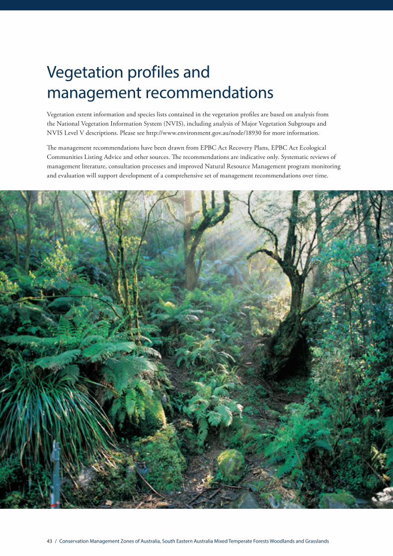
43 / Conservation Management Zones of Australia, South Eastern Australia Mixed Temperate Forests Woodlands and Grasslands
Vegetation profiles and management recommendationsVegetation extent information and species lists contained in the vegetation profiles are based on analysis from the National Vegetation Information System (NVIS), including analysis of Major Vegetation Subgroups and NVIS Level V descriptions. Please see http://www.environment.gov.au/node/18930 for more information.
The management recommendations have been drawn from EPBC Act Recovery Plans, EPBC Act Ecological Communities Listing Advice and other sources. The recommendations are indicative only. Systematic reviews of management literature, consultation processes and improved Natural Resource Management program monitoring and evaluation will support development of a comprehensive set of management recommendations over time.

44 / Conservation Management Zones of Australia, South Eastern Australia Mixed Temperate Forests Woodlands and Grasslands
Eucalyptus woodlands with a tussock grass understorey vegetation profile
Protection Sustainable Agricultural Practice
Rehabilitation Fire Management
Wildlife Management
Weed Management
Feral Animal Management
Disease Management
Purchase high quality remnants into reservation.
Encourage uptake of conservation agreements and covenants on private land.
Maintain a 30-50 metre native vegetation buffer around remnants to protect against incursion by feral predators, weeds and spray drift.
Ban firewood collection and bush rock removal.
Retain standing dead trees and fallen timber.
Protect from road widening and maintenance activities.
Do not permit commercial apiarists to place bee hives within 3km of the remnant.
Limit or exclude grazing during drought, and spring/summer when native ground cover is in flower or seed.
Graze 3-days on; 28-days rest in late summer. 7-days on; 56-days rest in autumn and winter. Maintain 80% groundcover minimum and a sward height of 10cm at all times.
Protect paddock trees with fencing.
Avoid soil compaction from vehicles/machinery or stock camps.
Avoid herbicide and pesticide application in or near remnants.
Avoid cultivation, ripping and excavation.
Do not plant trees/shrubs into good condition, or derived grassland sites.
Replant indigenous species if the site shows no signs of natural regeneration after two years. Plant trees and shrubs at the same density evident in local, good quality grassy woodland sites.
Use high quality seed, of local provenance if possible.
Do not allow a full canopy to develop (which may shade out understorey species). Please seek advice from your local NRM organisation for advice on managing canopy species densities.
Don’t allow the remnant to become overly shrubby.
Please seek advice from your local NRM organisation prior to undertaking any fire management.
Fire intervals should be a minimum of 5 years, maximum of 40 years.
Apply mosaic burning in small areas at staggered intervals. Retain unburnt areas.
Ensure that appropriate weed control measures follow any burning activity.
Maintain and protect paddock trees as these provide critical links for wildlife movement.
If few mature, hollow-bearing trees are present, provide bird and arboreal mammal nesting boxes. Monitor boxes regularly for pest species such as Noisy Miners and Indian Mynas.
If fallen timber has been removed from remnant sites, add coarse woody debris (e.g. recycled untreated timbers) to provide habitat.
Monitor and manage densities of Eastern Grey Kangaroos.
Mow/slash sporadically and in a mosaic pattern in late summer or autumn after native ground layer plants have seeded.
Hand pulling, spot spraying and weed wiping are appropriate weed control measures.
Prevent weed introduction through adopting good hygiene measures and minimising soil disturbance.
Don’t stockpile topsoil within remnant areas.
Use machinery hygiene protocols and monitor for weeds afterwards, including when ripping to control rabbits.
Control feral grazers (deer, rabbits, goats) and erect fences where appropriate (e.g. of stock dams, individual guards for targeted plants).
Control feral predators including foxes, dogs, cats and pigs.
Do not push fallen timber into stacks or windrows as these form harbours for foxes, rabbits and cats.
18.29%Remaining
Change in extent
Pres
ent d
ay
Pre-
1750
37.6%
6.9%
Commonly found species within this communityEucalyptus camaldulensis; Eucalyptus microcarpa; Eucalyptus melliodora; Melaleuca parvistaminea; Melicytus dentatus; Cassinia arcuata; Eleocharis acuta; Pimelea curviflora; Themeda triandra; Elymus scaber; Microlaena stipoides; Dianella revoluta; tussock grass.
Management recommendations
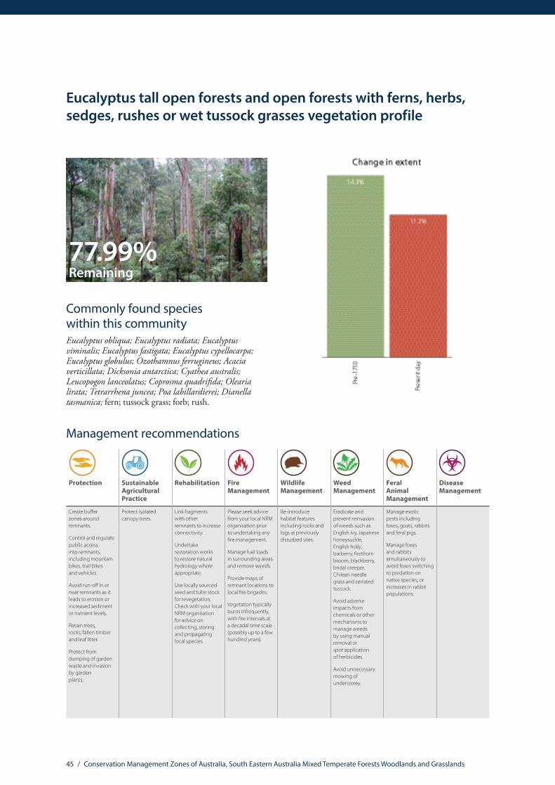
45 / Conservation Management Zones of Australia, South Eastern Australia Mixed Temperate Forests Woodlands and Grasslands
Eucalyptus tall open forests and open forests with ferns, herbs, sedges, rushes or wet tussock grasses vegetation profile
77.99%Remaining
Commonly found species within this communityEucalyptus obliqua; Eucalyptus radiata; Eucalyptus viminalis; Eucalyptus fastigata; Eucalyptus cypellocarpa; Eucalyptus globulus; Ozothamnus ferrugineus; Acacia verticillata; Dicksonia antarctica; Cyathea australis; Leucopogon lanceolatus; Coprosma quadrifida; Olearia lirata; Tetrarrhena juncea; Poa labillardierei; Dianella tasmanica; fern; tussock grass; forb; rush.
Protection Sustainable Agricultural Practice
Rehabilitation Fire Management
Wildlife Management
Weed Management
Feral Animal Management
Disease Management
Create buffer zones around remnants.
Control and regulate public access into remnants, including mountain bikes, trail bikes and vehicles.
Avoid run-off in or near remnants as it leads to erosion or increased sediment or nutrient levels.
Retain trees, rocks, fallen timber and leaf litter.
Protect from dumping of garden waste and invasion by garden plants.
Protect isolated canopy trees.
Link fragments with other remnants to increase connectivity.
Undertake restoration works to restore natural hydrology where appropriate.
Use locally sourced seed and tube stock for revegetation. Check with your local NRM organisation for advice on collecting, storing and propagating local species.
Please seek advice from your local NRM organisation prior to undertaking any fire management.
Manage fuel loads in surrounding areas and remove weeds.
Provide maps of remnant locations to local fire brigades.
Vegetation typically burns infrequently, with fire intervals at a decadal time scale (possibly up to a few hundred years).
Re-introduce habitat features including rocks and logs at previously disturbed sites.
Eradicate and prevent reinvasion of weeds such as English ivy, Japanese honeysuckle, English holly, barberry, firethorn broom, blackberry, bridal creeper, Chilean needle grass and serrated tussock.
Avoid adverse impacts from chemicals or other mechanisms to manage weeds by using manual removal or spot application of herbicides.
Avoid unnecessary mowing of understorey.
Manage exotic pests including foxes, goats, rabbits and feral pigs.
Manage foxes and rabbits simultaneously to avoid foxes switching to predation on native species, or increases in rabbit populations.
Management recommendations
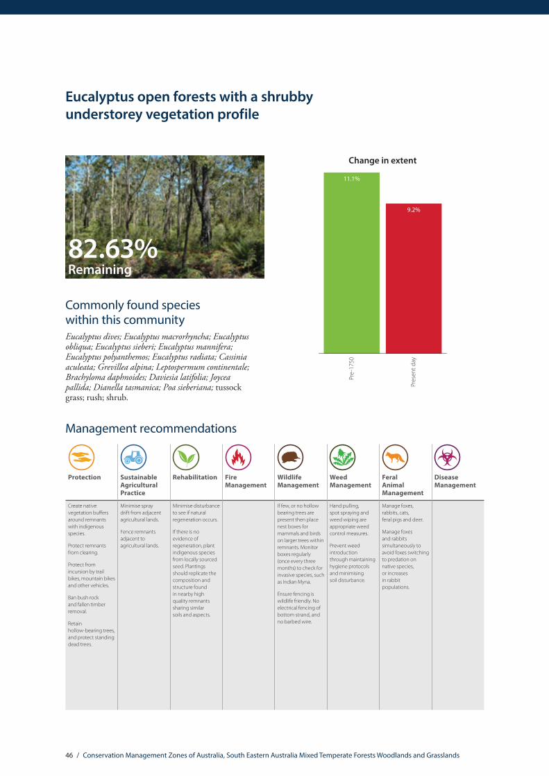
46 / Conservation Management Zones of Australia, South Eastern Australia Mixed Temperate Forests Woodlands and Grasslands
Eucalyptus open forests with a shrubby understorey vegetation profile
82.63%Remaining
Commonly found species within this communityEucalyptus dives; Eucalyptus macrorhyncha; Eucalyptus obliqua; Eucalyptus sieberi; Eucalyptus mannifera; Eucalyptus polyanthemos; Eucalyptus radiata; Cassinia aculeata; Grevillea alpina; Leptospermum continentale; Brachyloma daphnoides; Daviesia latifolia; Joycea pallida; Dianella tasmanica; Poa sieberiana; tussock grass; rush; shrub.
Change in extent
Pres
ent d
ay
Pre-
1750
11.1%
9.2%
Protection Sustainable Agricultural Practice
Rehabilitation Fire Management
Wildlife Management
Weed Management
Feral Animal Management
Disease Management
Create native vegetation buffers around remnants with indigenous species.
Protect remnants from clearing.
Protect from incursion by trail bikes, mountain bikes and other vehicles.
Ban bush rock and fallen timber removal.
Retain hollow-bearing trees, and protect standing dead trees.
Minimise spray drift from adjacent agricultural lands.
Fence remnants adjacent to agricultural lands.
Minimise disturbance to see if natural regeneration occurs.
If there is no evidence of regeneration, plant indigenous species from locally sourced seed. Plantings should replicate the composition and structure found in nearby high quality remnants sharing similar soils and aspects.
If few, or no hollow bearing trees are present then place nest boxes for mammals and birds on larger trees within remnants. Monitor boxes regularly (once every three months) to check for invasive species, such as Indian Myna.
Ensure fencing is wildlife friendly. No electrical fencing of bottom strand, and no barbed wire.
Hand pulling, spot spraying and weed wiping are appropriate weed control measures.
Prevent weed introduction through maintaining hygiene protocols and minimising soil disturbance.
Manage foxes, rabbits, cats, feral pigs and deer.
Manage foxes and rabbits simultaneously to avoid foxes switching to predation on native species, or increases in rabbit populations.
Management recommendations

47 / Conservation Management Zones of Australia, South Eastern Australia Mixed Temperate Forests Woodlands and Grasslands
Eucalyptus open forests with a grassy understorey vegetation profile
54.75%Remaining
Commonly found species within this communityEucalyptus goniocalyx; Eucalyptus pauciflora; Eucalyptus dives; Eucalyptus macrorhyncha; Eucalyptus polyanthemos; Eucalyptus nortonii; Eucalyptus dalrympleana; Cassinia aculeata; Cassinia longifolia; Acacia dealbata; Pimelea linifolia; Hardenbergia violacea; Epilobium billardierianum; Joycea pallida; Poa sieberiana; Austrostipa scabra; tussock grass; rush; forb.
Change in extent
Pres
ent d
ay
Pre-
1750
10.9%
6%
Protection Sustainable Agricultural Practice
Rehabilitation Fire Management
Wildlife Management
Weed Management
Feral Animal Management
Disease Management
Create native vegetation buffers around remnants with indigenous species.
Protect remnants from clearing.
Protect from incursion by trail bikes, mountain bikes and other vehicles.
Ban bush rock and fallen timber removal.
Retain hollow-bearing trees, and protect standing dead trees.
Minimise spray drift from adjacent agricultural lands.
Fence remnants adjacent to agricultural lands.
Minimise disturbance to see if natural regeneration occurs.
If there is no evidence of regeneration, plant indigenous species from locally sourced seed. Plantings should replicate the composition and structure found in nearby high quality remnants sharing similar soils and aspects.
If few, or no hollow bearing trees are present then place nest boxes for mammals and birds on larger trees within remnants. Monitor boxes regularly (once every three months) to check for invasive species, such as Indian Myna.
Ensure fencing is wildlife friendly. No electrical fencing of bottom strand, and no barbed wire.
Hand pulling, spot spraying and weed wiping are appropriate weed control measures.
Prevent weed introduction through maintaining hygiene protocols and minimising soil disturbance.
Manage foxes, rabbits, cats, feral pigs and deer.
Manage foxes and rabbits simultaneously to avoid foxes switching to predation on native species, or increases in rabbit populations.
Management recommendations

48 / Conservation Management Zones of Australia, South Eastern Australia Mixed Temperate Forests Woodlands and Grasslands
Eucalyptus woodlands with a shrubby understorey vegetation profile
72.65%Remaining
Commonly found species within this communityEucalyptus ovata; Eucalyptus obliqua; Eucalyptus leucoxylon; Eucalyptus pauciflora; Eucalyptus baxteri; Eucalyptus dives; Eucalyptus viminalis; Melaleuca squarrosa; Leptospermum continentale; Calytrix tetragona; Xanthorrhoea australis; Acacia verticillata; Drosera peltata; Lepidosperma carphoides; Hypolaena fastigiata; Tetratheca ciliata; Gahnia radula; Neurachne alopecuroidea; forb; sedge; tussock grass; rush.
Change in extent
Pres
ent d
ay
Pre-
1750
5.5%
4%
Protection Sustainable Agricultural Practice
Rehabilitation Fire Management
Wildlife Management
Weed Management
Feral Animal Management
Disease Management
Purchase high quality remnants into reservation. Encourage uptake of conservation agreements and covenants on private land.Maintain a 30–50 metre native vegetation buffer around remnants to protect against incursion by feral predators, weeds and spray drift.Ban firewood collection and bush rock removal.Retain standing dead trees and fallen timber. Protect from road widening and maintenance activities. Do not permit commercial apiarists to place bee hives within 3km of the remnant.
Manage grazing practices including avoiding high-intensity set stocking. Limit or exclude grazing during drought periods and during spring and summer when native ground cover is in flower or seed.
Avoid herbicide and pesticide application in or near remnants.
Do not direct or divert run-off into remnant areas.
Avoid soil compaction from vehicles/machinery or stock camps.
Avoid cultivation, ripping and excavation.
Do not plant trees/shrubs into good condition, or derived grassland sites.
Replant native, indigenous species if the site shows no signs of natural regeneration after two years. Plant trees and shrubs at the same density evident in local, good quality grassy woodland sites.
Use high quality seed, of local provenance if possible.
Do not allow a full canopy to develop (which may shade out understorey species). Please seek advice from your local NRM organisation on managing canopy species densities.
Please seek advice from your local NRM organisation prior to undertaking any fire management actions.
A minimum fire interval of five years, maximum of 40 years is recommended.
Apply mosaic burning in small areas at staggered intervals. Retain unburnt areas.
Ensure that appropriate weed control measures follow any burning activity.
If few, or no hollow bearing trees are present then place nest boxes for mammals and birds on larger trees within remnants. Monitor boxes regularly (once every three months) to check for invasive species, such as Indian Myna.
Hand pulling, spot spraying and weed wiping are appropriate weed control measures.
Prevent weed introduction through maintaining hygiene protocols and minimising soil disturbance.
Control feral grazers (deer, rabbits, goats) and erect fences where appropriate (e.g. of stock dams, individual guards for highly palatable young plants).
Control feral predators including foxes, dogs, cats and pigs.
Management recommendations

49 / Conservation Management Zones of Australia, South Eastern Australia Mixed Temperate Forests Woodlands and Grasslands
Temperate tussock grasslands
7.30%Remaining
Commonly found species within this communityThemeda triandra; Allocasuarina verticillata; Poa sieberiana; Poa labillardierei; Austrodanthonia caespitosa; Acacia melanoxylon; Eucalyptus camaldulensis; Acacia paradoxa; Elymus scaber; Austrodanthonia setacea; other grass; tussock grass; forb.
Change in extent
Pres
ent d
ay
Pre-
1750
4.9%
0.4%
Protection Sustainable Agricultural Practice
Rehabilitation Fire Management
Wildlife Management
Weed Management
Feral Animal Management
Disease Management
Encourage uptake of conservation agreements and covenants on private land.
Purchase good quality remnants into reservation where possible.
Remnants in travelling stock routes should be monitored carefully to ensure that they do not become degraded.
Avoid soil disturbance such as ploughing, creation of vehicle tracks, stockpiling, or rock removal.
Create native vegetation buffers of greater than 30 metres.
Prevent trampling and excessive grazing pressure.
Graze 3 days on; 28 days rest period.
Totally exclude grazing during spring and summer flowering and seeding periods.
Maintain a minimum sward height of 10cm at all times (across all the site).
Avoid fertiliser and herbicide application in or near remnants. Where cropping is undertaken in adjacent paddocks, minimise spray drift into remnants.
Consult your local NRM Organisation for advice on appropriate revegetation methods.
Rehabilitate sites with locally sourced seed. Monitor closely to ensure that weed species do not compete with young native recruits for soil moisture and light.
Revegetate between existing remnants to reconnect, extend and buffer sites.
Please seek advice from your local NRM organisation prior to undertaking any fire management actions.
Ensure any fencing of remnants is wildlife friendly, is not electrified and does not contain barbed wire.
Manage weeds including Chilean Needle Grass, African Lovegrass, Serrated Tussock Grass and St Johns Wort.
Avoid adverse impacts from chemicals or other mechanisms to manage weeds.
Avoid disturbance during peak flowering season (no mow/ slash/burn).
Ensure weed seed not spread by grazing or machinery.
Maintain cover of native perennials.
Undertaking baiting for foxes and cats.
Ensure grass dependent fauna are not affected by feral animal trapping/removal program.
Management recommendations

ALC
100.
0915


![SCHEER ELEKTROHANDWERKZEUGE · SCHEER - ELEKTROHANDWERKZEUGE Ersatzteilliste Handoberfräse HM 18-E [Text eingeben] WERK WIERNSHEIM • 75446 Wiernsheim • Lindenstraße 70 • Tel.(07044)9617-0](https://img.pdfslide.net/doc/110x75/5c01d63009d3f279018d462e/scheer-ele-scheer-elektrohandwerkzeuge-ersatzteilliste-handoberfraese-hm-18-e.jpg)