Embed Size (px)
Citation preview
Conserving America's Wetlands
AcknowledgementsMany agencies, institutions, and individuals contributed their time, energ y,and expertise to the completion of this report, as follows:
James L. Connaughton, Chairman, CEQJim T. Bates, Associate Director, OMB
White House Wetlands Working Group
Gregory Schildwachter, CEQGeorge Dunlop, DOATyler Duvall, DOTRob Fairweather, OMBBenjamin Grumbles, EPAMike Hickey, OMBTimothy Keeney, NOAAArlen Lancaster, USDADavid Verhey, DOI
Core Work Team
Mike Hickey, OMBCharles Stern, OMBJo Ann Mills, FWSJennifer Wallace, NOAABill Wilen, FWS
Working Group Staff
Bill Wilen, DOI/FWS, LeadAstor Boozer, USDA/NRCSEllen Cummings, USACEJason Goldberg, DOI/FWSCamille Mittelholtz, DOTGregory Peck, EPAMyra Price, EPACindy Ryberg, DOIDave Stout, FWSMark Sudol, USACEJennifer Wallace, NOAA
Production
Mark Newcastle, DOI/FWSFrances Pflieger, DOC/NOAAJerry Slaff, DOC/NOAA
This report to Congress shows how federal agencies implemented President George W. Bush’s 2004 Earth Daygoal to “work to restore and to improve and to protect at least three million acres of wetlands over the nextfive years.” The report includes the accomplishments of the first four years and the requested budget andplanned accomplishments for FY 2009, with descriptions of contributing federal programs.
The White House Council on Environmental Quality730 Jackson Place
Washington, DC 20503
http://www.whitehouse.gov/ceq/
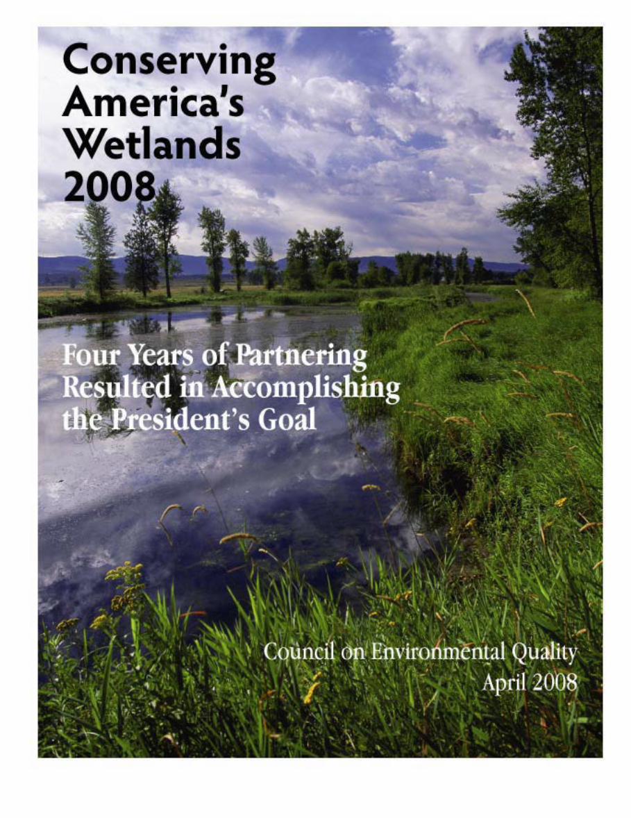
Cover photo: Lee Metcalf National Wildlife Refuge, Montana. (Hillebrand, FWS)
Conserving America’s Wetlands 2008:Four Years of Partnering
Resulted in Accomplishingthe President’s Goal
Department of Agriculture
Department of Commerce
Department of Transportation
Department of the Army
Department of the Interior
Environmental Protection Agency
Council on Environmental QualityApril 2008

Members of Congress:On Earth Day 2004, the President set a bold new goal to move beyond the national policy of “no net loss” of wetlands to one
of achieving an overall gain by creating, improving, and protecting three million acres of wetlands by Earth Day 2009. I am pleasedto inform you, in this fourth annual progress report on President George W. Bush’s Wetlands Initiative, that the President’s goal hasbeen achieved and exceeded. And we have accomplished this goal one year ahead of schedule. More than 3.6 million acres ofwetlands have been restored, protected, or improved in the four years since the President established our new national goal. ByEarth Day 2009, the original date set forth in the President’s initiative, we anticipate that nearly 4.5 million acres of wetlands willlikely be restored, protected, or improved, exceeding the President’s goal by 50 percent.
This report chronicles the contributions of federal agencies—working together and in partnership with state and localgovernments, corporations, and a wide range of nongovernmental organizations and individuals—to achieve the President’sconservation vision.
Our collective accomplishments are a testament to the effectiveness of proactive conservation programs, such as the WetlandsReserve Program, National Wildlife Refuge System, North American Wetlands Conservation Act, Aquatic Ecosystem RestorationProgram, and the National Estuary Program. These programs cover 20 times more area than our regulatory mitigation programs thatreplace wetlands developed for other uses. Regulatory agency programs deliver on the “no overall net loss of wetlands” policy byreplacing the ecological functions of wetlands developed, which amounts to about two acres of wetlands conservation for every acreof development, or a total of 46,000 acres of mitigation for about 23,000 acres of wetlands developed in a given year. The real large-scale conservation, however, is taking place through programs contributing to the President’s Wetland Goal, which have conservedapproximately 900,000 acres annually.
Cooperative Conservation continues to be the cornerstone of our ongoing success. Under the Cooperative ConservationExecutive Order 13352, the Departments of Interior, Agriculture, Commerce, and Defense, and the Environmental Protection Agency,work in partnership with each other and with state, local, and tribal governments; private institutions; and other nongovernmentalentities and individuals to meet conservation goals. These partnerships leverage the best of what each has to offer. Through CoastalAmerica’s Corporate Wetlands Restoration Partnership, more than 400 corporations and NGOs work together to provide matchingfunds and in-kind services, resulting in significant contributions to wetlands restoration and protection.
While we have achieved much in these past four years, we must continue our conservation efforts with the same sense ofpurpose that has resulted in exceeding the aggressive goal set by the President in 2004. Future progress will depend on our closeattention to the types and quality of wetlands. Many of the wetlands we are restoring or improving through the cross-cuttingprograms of this initiative involve planting grasses and trees, or flooding areas to create habitat for wetland species. Over time, asplants mature, shallow-water wetlands will become meadow or forested wetlands. We must ensure this succession of growth resultsin a distribution of wetland types serving diverse ecological roles that benefit wildlife as well as communities and people. Thesuccess of future wetlands conservation will continue to rely on the teamwork and dedication that has brought us this far. ThePresident appreciates the time and efforts of all, both in and outside of government, who work together to conserve, protect, andenhance our nation’s valuable wetlands.
Sincerely,
James L. ConnaughtonChairman

Contents
Executive Summary .......................................................................................................................................................1
Introduction ..................................................................................................................................................................3
Accomplishments ..........................................................................................................................................................5Restore or Create Wetlands ...................................................................................................................................................... 5Improve Wetlands .................................................................................................................................................................... 8Protect Wetlands ..................................................................................................................................................................... 12
Perspective ................................................................................................................................................................... 17
Appendix A. Methodology and Definitions ................................................................................................................ 21
Appendix B. Conserving Wetlands ..............................................................................................................................25
Appendix C. Department of Agriculture (USDA) ........................................................................................................31
Appendix D. Department of Commerce, National Oceanic and Atmospheric Administration (NOAA) ....................35
Appendix E. Department of the Army, U.S. Army Corps of Engineers, Civil Works (USACE) ...................................39
Appendix F. Department of the Interior (DOI) .......................................................................................................... 43
Appendix G. Department of Transportation (DOT) ...................................................................................................51
Appendix H. Environmental Protection Agency (EPA) ...............................................................................................53
Appendix I. Coastal Wetlands Planning, Protection and Restoration Act (CWPPRA) ................................................55
Acronyms .....................................................................................................................................................................57

1
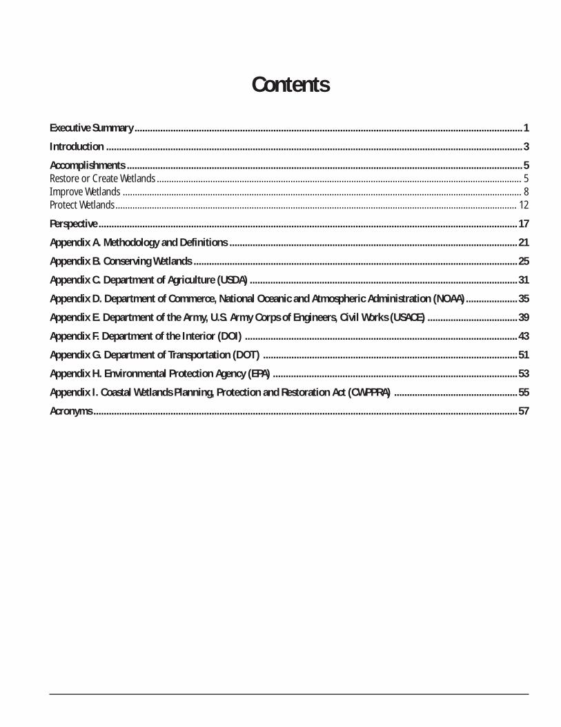
Executive Summarys'tnediserP
yaDhtraEslaoG9002
stnemhsilpmoccAruoFtsriFehtnihtraEretfasraeY
*4002yaD
detcejorPstnemhsilpmoccA9002yaDhtraEyb
detaerCroderotseRsercA 000,000,1 000,791,1 000,674,1
devorpmIsercA 000,000,1 000,970,1 000,713,1
detcetorPsercA 000,000,1 000,423,1 000,007,1
sercAlatoT 000,000,3 000,006,3 000,394,4
*As adjusted by actual results
On Earth Day 2004, President Bush celebrated the oppor-tunity to move beyond the
federal policy of “no net loss” ofwetlands and called for a newcommitment to attain an overallincrease in the quality and quantityof wetlands in America.
As President Bush said in April2004, “The old policy of wetlands wasto limit the loss of wetlands. Today,I’m going to announce a new policyand a new goal for our country:Instead of just limiting our losses...we will move beyond the nonet loss of wetlands in America to having an overall increase ofAmericans’ wetlands over the next five years.”
President Bush described achieving his goal for expand-ing wetlands acreage by restoring or creating, improving andprotecting “at least three million acres of wetlands over thenext five years.” The goal is to achieve at least one million acresin each of these separate categories between Earth Day 2004and Earth Day 2009. This goal reflects federal agency perfor-mance in restoring, improving, and protecting wetland acres.The three million acre target does not reflect a net acreage total(i.e., only additional wetlands are tabulated, not losses ofwetlands).
After four years of working toward the President’s five-year goal, the team of six federal agencies working with multiplestates, communities, tribes, and private landowners haveexceeded the three million acre target a year early.
Since the President established the goal, 3,600,000 acresof wetlands have been restored or created, improved, orprotected.
This report also highlights anticipated progress betweenEarth Day 2008 and Earth Day 2009, during which time theBush Administration expects an additional 893,000 wetlandacres to be restored or created, improved, or protected.
The President’s focus on wetlands has prompted theseaccomplishments, as well as improvements in cooperation andunderstanding among the many federal departments, states,
communities, tribes, and landowners that care for and managewetlands. The federal government team includes the Environ-mental Protection Agency and the Departments of Agriculture,Commerce, Interior, Transportation, and the Army.
Many government agencies contribute to the continuinggoal of “no net loss” by ensuring mitigation for wetlands thatare developed for other uses. Even though mitigation forwetlands replaces more wetland acres than are lost, thesenumbers are not included in the three categories reportedhere. The report describes these and other programs thatcontribute to maintaining the nation’s wetlands base.
This report chronicles the major contributions of federalagencies, working together and in partnership with others, thathave exceeded each of the categories—and have done it a fullyear ahead of schedule.
Wetlands have long been recognized as critical to a clean,properly functioning environment and to ecosystem health.They provide a protective buffer for our towns and citiesagainst floods and storm surges, and they provide importantecological benefits, contributing to water quality, supplying life-sustaining habitat for hundreds of species, and connectingaquatic and terrestrial ecosystems. The nation’s wetlandsprovide an array of benefits to society, and their continuedability to function and thrive affects the economic, ecological,and cultural heritage of all Americans.
2
Wetlands Loss in Coastal Areas: Bucking the National “Net Gain” Trend
Coastal wetlands are all wetlands in coastal watersheds,i.e., local watersheds that drain to the ocean, theGreat Lakes, or an estuary or bay. Coastal wetlands
include salt marshes, bottomland hardwood swamps, freshmarshes, seagrass beds, mangrove swamps, and shrubbydepressions known in the southeast United States as “po-cosins.” Coastal wetlands and estuaries are extremelyimportant as nursery, refuge, foraging, and spawning areas forestuarine, marine, and anadromous fish. Coastal wetlandscurrently make up about 38 percent of the wetlands in thelower 48 states, or approximately 41 million acres.
Wetland trends in the conterminous United States havebeen measured and reported periodically by the U.S. Fishand Wildlife Service (FWS). Nationwide, net wetland loss hasdecreased from about 458,000 acres per year in the 1960sto 58,500 acres in the late 1990s. In the most recent period,1998–2004, there was a slight increase in wetlands in theconterminous United States.
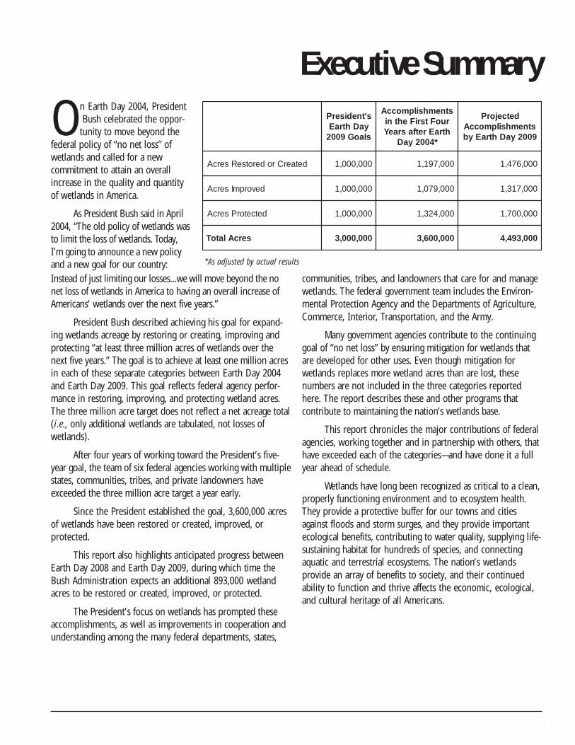
Volunteers at a restoration project in the Lafourche Parish, Louisiana, work to plant salt marsh grasses and place sand fencing, which will helpstabilize new habitat conditions created by the project. (NOAA)
Because coastal wetlands have not been tracked as adistinct category in the existing FWS reports, the NationalOceanic and Atmospheric Administration (NOAA) partneredwith the FWS to assess the status and trends of wetlands inthe coastal watersheds of the Great Lakes, Atlantic Ocean,and Gulf of Mexico, for the period 1998–2004. Initialindications from the effort reflect that during this periodcoastal watersheds possibly were losing a substantialamount of wetlands, despite the national trend of net gain.Final results of the study are expected to be released in ajoint NOAA/FWS report during the summer of 2008.
Although the wetlands targets presented by thePresident in 2004 have been met nationwide, it is almostcertain that wetlands will continue to be lost in coastalwatersheds. Because people enjoy living near the coast, theycontinue to build roads, homes, and other structures incoastal watersheds. Emphasis on coastal wetland conserva-tion—both protection and restoration—in federal, state, andother wetland programs will be needed to address this lossof coastal wetlands.
3
Introduction
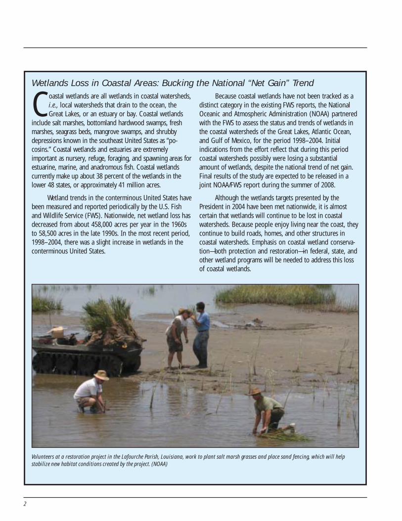
Figure 1. Anticipated Progress Toward the President’s Wetlands Goal
Note: Values have been adjusted for double-counted acres.
The importance of wetlands stewardship is reflected in thearray of public–private partnerships that have formed,enhanced through efforts at the federal level. Recogniz-
ing the need for more effective use and coordination of federalwetlands activities, on April 22, 2004, President George W.Bush announced a new national policy and goal on wetlands toachieve an overall increase of U.S. wetlands each year, byrestoring or creating, improving, or protecting at least threemillion wetland acres between Earth Day 2004 and 2009. TheDepartments of the Interior, Agriculture, Commerce, Transpor-tation, and the Army, and the Environmental Protection Agencyhave exceeded this target a year ahead of schedule in partner-ship with state, local, and tribal governments; private institu-tions; other nongovernmental entities; and individuals.
To achieve the President’s wetlands goal for Earth Day2009, the President specifically called for:
• Restoring or creating at least one million wetland acres;• Improving or enhancing at least one million wetland acres;• Protecting at least one million wetland acres.
All three of these targets have been met a year early.Between Earth Day 2004 and 2008, approximately 1,197,000acres have been restored or created, 1,079,000 acres have beenimproved, and 1,324,000 acres have been protected (Figure 1).Agencies expect to add an additional 893,000 acres throughEarth Day 2009.
Since Earth Day 2004, the primary programs makingcontributions to restoration or creation are:
• Wetlands Reserve Program (USDA/NRCS);• North American Wetlands Conservation Act (DOI/
FWS);• National Wildlife Refuge System (DOI/FWS);• Conservation Reserve Program (USDA/FSA);• Conservation Technical Assistance (USDA/NRCS);• Partners for Fish and Wildlife Program (DOI/FWS);• Coastal Wetland Planning, Protection, and Restoration
Projects, LA (USACE, EPA, FWS, NOAA, NRCS);• Aquatic Ecosystem Restoration Program (DOA/Civil
Works);
-
200,000
400,000
600,000
800,000
1,000,000
1,200,000
1,400,000
1,600,000
1,800,000
Restore or Create Improve Protect
acre
s
Earth Day 2009
Earth Day 2008
Earth Day 2007
Earth Day 2006
Earth Day 2005
4
• North American Waterfowl Management Plan–JointVentures (DOI/FWS); and
• National Estuary Program (EPA).
The primary contributors to wetlands improvement are:
• North American Wetlands Conservation Act;• Coastal Wetland Planning, Protection, and Restoration
Act, La.;• Wetlands Reserve Program;• National Wildlife Refuge System;• Conservation Technical Assistance;• Partners for Fish and Wildlife Program;• North American Waterfowl Management Plan–Joint
Ventures;• Aquatic Ecosystem Restoration Program; and• National Estuary Program.
Wetlands protection through acquisitions or long-termeasements is being accomplished by:
• North American Wetlands Conservation Fund;• Wetlands Reserve Program;• National Wildlife Refuge System;• National Estuary Program; and• Migratory Bird Conservation Fund (DOI/FWS).Because more than 85 percent of our nation’s wetlands are
on non-federal lands, the effectiveness of federal efforts toimprove the health, quality, and use of the nation’s wetlands willbe greatly enhanced by expanding public–private partnerships.Through cooperative conservation, the federal government canfacilitate these partnerships by providing matching grants,
technical assistance, and opportunities for the re-establishment,rehabilitation, enhancement, and protection of wetlands.
Federal agencies must continue to encourage and partnerwith non-federal parties (state and local governments, tribes,and nongovernmental organizations). Well-coordinated public–private partnerships focused on wetlands opportunities willyield significant ecological benefits. Our ecology and economyare interdependent; a healthy environment and strongeconomy must both flourish.
About This ReportConserving America’s Wetlands 2008: Four Years of
Partnering Resulted in Accomplishing the President’s Goaldocuments attempted progress toward the President’s goal toexpand our nation’s wetlands by creating, improving, andprotecting at least three million acres of wetlands. In providinginformation, the participating agencies used terminology similarto that developed by the White House Wetlands Working Groupand the same terminology used in previous editions of thisreport. Agencies reported all notable accomplishments towardthe President’s goal in the year the project was completed, orprojected to be completed, rather than the year the project wasfunded. Adjustments were made to account for projectsreported by multiple agencies (“double-counting”). Projectedestimates in the 2007 report were adjusted in this year’s reportas actual results became available. Appendix A provides athorough discussion of terminology and methodology, Appen-dix B describes efforts that help maintain the wetlands base,and Appendices C through I present program-level informationand descriptions by agency.
5
Accomplishments
Figure 2. Proportion of Wetland Acres Anticipated to be Restored or Createdby Major Programs in FY 2009
The President’s goal for wetlands has led the responsiblefederal agencies to focus their resources to achievemeaningful results. Agencies do this by managing programs
more strategically, leveraging resources, and partnering withothers whenever possible. The following sections summarizeaccomplishments planned for each of the three goal areas. Majorcontributing programs in FY 2009 are identified and highlighted.Wetland Reserve accomplishments reflect the anticipatedincrease in the wetland enrollment acreage cap and mandatoryfunding under the new Farm Bill, assuming that all authorizedacres are enrolled.
Restore or Create
After Four Years of Accomplishment: 1,197,000 acresEstimated Accomplishment Earth Day 2009: 279,000 acres(totals adjusted for double-counting )
Wetlands can be added by creating new wetlands or byrestoring former wetlands lost to drainage or inundation. Newwetlands are created in upland areas or deepwater sites. A gainin wetland acres may also be achieved by re-establishing formerwetlands to restore functions and values approximatingnatural/historic conditions. Because of difficulties in establish-ing wetlands in upland areas, agencies have preferred to re-establish former wetlands when possible. In many cases, thenecessary soils and seed stock still exist, and wetlands flourishonce more as soon as the hydrology is restored.
During the first four years (April 2004 through April2008), federal agencies reported restoring or creating1,197,000 acres of new wetlands. By Earth Day 2009, federalagencies plan to restore or create an additional 279,000 acresof wetlands. During the first four years, 95 percent of the gainsresulted from re-establishing former wetlands, and five percentfrom establishing (i.e., creating new) wetlands (primarily onupland sites).
The federal government will restore wetlands in FY 2009primarily through the Wetlands Reserve Program, NorthAmerican Wetlands Conservation Act, Partners for Fish andWildlife Program, National Wildlife Refuge System, ConservationReserve Program, and Conservation Technical AssistanceProgram (Figure 2).
Wetlands Reserve ProgramThis voluntary program provides technical and financial
assistance to eligible landowners to address wetland, wildlifehabitat, soil, water, and related natural resource concerns onprivate lands. The program provides financial incentives forlandowners to restore, protect, and enhance wetlands inexchange for retiring marginal land from agriculture. Enroll-ment options include permanent easements, 30-year ease-ments, and restoration cost-share agreements.
The Wetlands Reserve Program ( WRP) was reauthorizedin the Farm Security and Rural Investment Act of 2002 (Farm
24%
23%
15%
10%
8%
5%
15%
Wetlands Reserve Program
North American Wetlands Conservation Act
Partners for Fish and Wildlife Program
National Wildlife Refuge System
Conservation Reserve Program
Conservation Technical Assistance Program
Other (See Tables C-2, D-2, E-2, F-2,H-2, I-2)
6
Bill). The program is administered by NRCS and funded by theCommodity Credit Corporation. In FY 2007, NRCS state officessecured 379 easements on approximately 74,508 acres.
The types of wetlands restored by NRCS through thisprogram vary, from floodplain forest to prairie potholes tocoastal marshes. Historically, floodplain forest and associatedsloughs and small emergent marsh wetlands account forapproximately 65 percent of the program’s restoration activity.A majority of the enrolled floodplain acres offered into theprogram occur in areas subject to frequent flooding that wereoriginally drained or cleared for agricultural production.
WRP expects to restore or create approximately 79,000acres of wetlands in FY 2008 and84,000 acres in FY 2009.
North AmericanWetlands ConservationAct
This FWS program promoteslong-term conservation of NorthAmerican wetland ecosystems for thebenefit of waterfowl and othermigratory birds, fish, and otherwildlife. Funds are provided byappropriations and bynonappropriated sources such as theCoastal Wetlands Planning, Protec-tion and Restoration Act (CWPPRA);interest earned on Pittman-RobertsonWildlife Restoration program funds;
flows to 970 acres to re-establish estuarine intertidal wetlandsand streams, rehabilitate 149 acres of palustrine wetlandhabitat, and link these wetlands to 2,000 acres of previouslyrestored wetland habitat in the refuge.
Six partners—including state and county agencies,conservation organizations, and a private foundation—areproviding $9,722,000 in contributions to match the $1 millionNAWCA grant. $941,750 of the NAWCA grant will be allocatedto habitat restoration. The partnership’s protection andrestoration plans will support other ongoing regional conserva-tion efforts in Sonoma County and will improve habitatconnectivity between completed and future wetland restora-tion projects.
and fines collected under theMigratory Bird Treaty Act.
In FY 2007, NAWCA initiatedthe Sonoma Baylands Wetlands Restoration Project in Califor-nia, a planned multi-phase program headed by the SonomaLand Trust to protect and restore wetland and associatedupland habitats in the north San Pablo Bay area of SonomaCounty. The project will permanently protect 4,064 acres ofwetland habitat via fee title acquisitions, and re-establish orrehabilitate a minimum of 1,019 acres of these acquired acres.The wetlands to be restored include estuarine and freshwateremergent and forested habitats. One of the primary restorationprojects will occur on Sears Point, part of the San Pablo BayNational Wildlife Refuge, where the partners will restore tidal
NAWCA expects to restore or create approximately79,000 acres of wetlands in FY 2008 and FY 2009.
Partners for Fish and Wildlife ProgramThe Partners for Fish and Wildlife Program is a popular
and effective FWS program for voluntary and citizen-basedwetlands restoration and enhancement activities. The Partnersprogram serves as a bridge to owners and managers of privatelands to develop partnerships for improvement of fish andwildlife populations and their habitats. Its approach is simple:engage willing partners, through nonregulatory incentives, to
Six partners will restore tidal flows to 970 acres to re-establish estuarine intertidal wetlands and streamsand link these wetlands to 2,000 acres of previously restored wetland habitat on San Pablo Bay NationalWildlife Refuge in Sonoma County, California. This project was made possible by a NAWCA grant. (FWS)
7
conserve and protect wildlife values on their property. As thedelivery mechanism for strategic habitat conservation, thePartners program staff coordinates with public and privatepartners to reach national conservation goals. By workingcooperatively with private landowners to restore and enhancehabitat on private lands, the Partners program helps reduce thereliance on regulation to achieve the FWS mission of conservingTrust species and keeping common species common.
The Partners for Fish and Wildlife Program in SouthDakota restored three wetlands totaling 11.3 acres in associa-tion with a grassland seeding in a Conservation ReserveProgram field. The wetland restorations were designed by aPartners’ biologist, and construction was completed by FWSpersonnel and equipment. This project is part of a decade-longpartnership between USDA, Ducks Unlimited, and the Partnersprogram to restore wetlands in Conservation Reserve Program(CRP) tracts. Over the past 10 years, this partnership hasresulted in 406 restored wetlands totaling 1,339 acres. Inaddition, the Partners program is actively working with land-owners to develop options for retaining CRP grasslands forgrazing, as opposed to converting the grassland back to tillageagriculture. Upon expiration of a CRP contract, Partners’biologists work closely with landowners to develop a grazingmanagement plan for the area. The goal is to provide a suite of
conservation practices and technical assistance to helplandowners optimize rangeland health on expired CRP tracts.
The Partners program expects to restore or createapproximately 51,000 acres of wetlands in FY 2008 and FY 2009.
National Wildlife Refuge SystemThe mission of the National Wildlife Refuge System,
managed by FWS, is to administer a national network of landsand waters for the conservation, management, and whereappropriate, restoration of the fish, wildlife, and plant re-sources and their habitats within the United States for thebenefit of present and future generations of Americans. InOregon, FWS and partners completed an 82-acre tidal marshrestoration project on Nestucca Bay National Wildlife Refuge inthe fall of 2007. The project site is located in the upper estuaryalong the Little Nestucca River and was composed of fiveprivate ownerships prior to acquisition by the refuge. Over acentury ago, this area was diked and drained, converting themarsh to pastures for dairy farms. The restoration project wasdesigned and implemented by the FWS, Ducks Unlimited, andthe Confederated Tribes of the Siletz Indians. Partners contrib-uting funds to the FWS for the restoration included DucksUnlimited, Oregon Watershed Enhancement Board, NationalFish and Wildlife Foundation, Oregon Coastal Program, Pacific
Coast Joint Venture, James H. StanardFamily Foundation, The NatureConservancy, and Tillamook People’sUtility District. Siuslaw NationalForest, Oregon Department of Fishand Wildlife, and William L. FinleyNational Wildlife Refuge provided in-kind services and materials. A diverseassemblage of wildlife speciesincluding migratory waterfowl,wading birds, and raptors areresponding rapidly to the recoveringintertidal habitats. Fish documentedusing the area since restorationinclude juvenile coho and Chinooksalmon, cutthroat trout, and otherestuarine-dependent fish.
The NWRS anticipates restoring34,000 acres of wetlands in FY 2008and FY 2009 through re-establishingwetlands on former sites.This wetland restoration project—in a focus area of the South Dakota Partners for Fish and Wildlife
Program—benefits high-priority migratory bird species. (FWS)
8
Conservation Reserve ProgramThis USDA program restores wetlands, ranging from prairie
potholes to floodplains to bottomland hardwood forest. Cur-rently, one million acres of wetlands and 1.4 million acres ofassociated buffers are under long-term contracts. CRP wetlandsuccesses include partnerships with states through the Conserva-tion Reserve Enhancement Program (CREP), which has enrolledover 87,000 acres of wetlands and associated buffers. Inaddition, in August 2004, President Bush announced the Non-Floodplain Wetland Restoration Initiative to encourage landown-ers to enroll 250,000 acres of large wetland prairie potholecomplexes and playa lakes located outside the 100-year flood-plain. These wetlands provide important environmental benefits,including critical breeding habitat for ducks and grassland birds.Wildlife biologists at the Department of the Interior estimate thatCRP efforts have resulted in a 30 percent increase in duckpopulations and significant increases in grassland bird popula-tions on CRP lands compared to cropland.
Other CRP wetland restoration initiatives include theprairie pothole duck nesting initiative and the constructedtreatment wetlands implemented in the Iowa CREP. The ducknesting initiative, which began in 2006, provides for enrollmentof up to 100,000 acres in prairie pothole lands targeted towetland and surrounding nesting habitat. The Iowa CREPproject creates wetlands in tile-drained cropland that removenitrogen from the drainage water, while providing otherwetland benefits.
The Conservation Reserve Program anticipates restoringor creating 17,000 acres of wetlands in FY 2008 and another26,000 acres in FY 2009.
Conservation Technical Assistance ProgramThe broad purpose of NRCS’s Conservation Technical
Assistance (CTA) Program is to help private landowners,conservation districts, tribes, and other organizations byproviding technical assistance through a national network oflocally respected, technically skilled, professional conservation-ists. These conservationists deliver consistent, science-based,site-specific solutions to help private landowners conserve,maintain, and improve the nation’s natural resource base. TheCTA Program provides the foundation for NRCS to assistfarmers, ranchers, other landowners, local groups, tribes, andlocal governments to plan and implement natural resourceconservation systems.
In FY 2007, CTA was the major source of technicalassistance for planning and applying conservation practicesand systems to conserve and enhance natural resources onnon-federal land. These conservation actions delivered publicbenefits in the form of better soil quality, reduced delivery ofsediment and nutrients to surface and ground waters, increasedconservation of water supplies, healthier grazing and forestland ecosystems, diverse and healthier wildlife habitat, andimproved wetlands condition and function.
An example of the success NRCS has attained in creatingand re-establishing wetlands is the construction of duck wingshaped terraces in Jefferson Parish, Louisiana. In 2007, the CTAProgram partnered with Ducks Unlimited, Louisiana Depart-ment of Natural Resources, Crescent Soil and Water Conserva-tion District, Barataria-Terrebonne National Estuary Program,Louisiana State University Extension Service, and JeffersonParish local government to plan, design, construct, and vegetate18,750 linear feet of earthen terraces in Jefferson Parish,Louisiana. The terraces were constructed 2.5 miles south ofLafitte, Louisiana, along Barataria Waterway east and west ofDupree Cut. Thirty-six duck wing terraces averaging 500 linearfeet were constructed to calm wind effect in open water areas,to re-establish submersed aquatic vegetation to restorewetlands, and to reduce erosion along adjacent shorelines.Existing berms and levees were repaired to maintain adequatewater levels in the project area. This wetland restorationproject also enhanced a total 5,437.5 acres of intermediate tobrackish coastal marsh, thus benefiting a diverse array ofmigratory birds and other wildlife in the area.
The Conservation Technical Assistance Program expectsto restore or create approximately 17,000 acres of wetlands inFY 2008 and FY 2009.
Improve Wetlands
After Four Years of Accomplishment: 1,079,000 acresEstimated Accomplishment Earth Day 2009: 238,000 acres(totals adjusted for double-counting )
Some degraded wetlands do not function properlybecause of past or present stressors. Agencies can improvewetlands by modifying the physical, chemical, or biologicalcharacteristics of a degraded wetland site with the goal ofrepairing its natural/historic functions and associated values(referred to as rehabilitation). They also can modify the
9
physical, chemical, or biological site characteristics to heighten,intensify, or improve specific functions or to change the growthstage or composition of vegetation. These actions are takenwith a specific goal in mind, such as improving water quality,floodwater retention, or wildlife habitat. This type of improve-ment, called enhancement, results in a change in wetlandfunctions and associated values, may lead to a decline in otherwetland functions and values, and does not result in a gain inwetland acres.
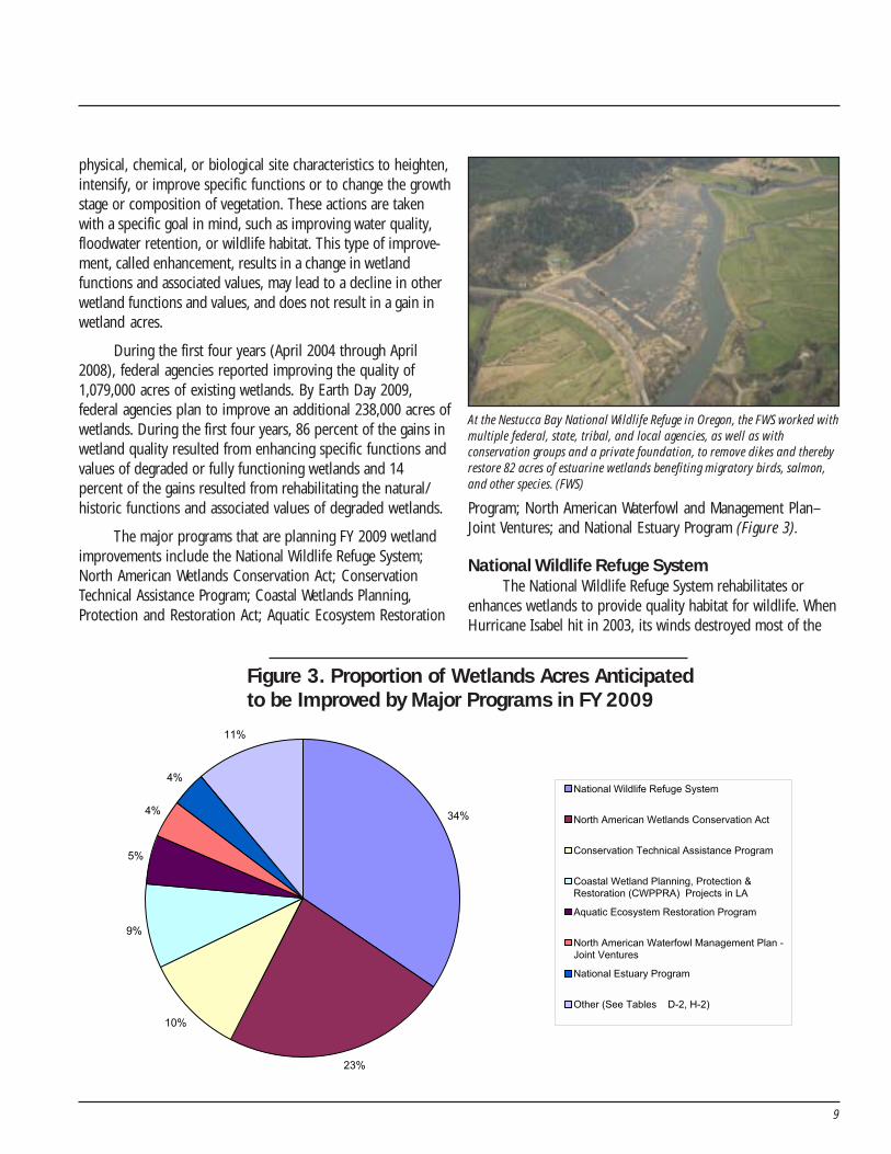
During the first four years (April 2004 through April2008), federal agencies reported improving the quality of1,079,000 acres of existing wetlands. By Earth Day 2009,federal agencies plan to improve an additional 238,000 acres ofwetlands. During the first four years, 86 percent of the gains inwetland quality resulted from enhancing specific functions andvalues of degraded or fully functioning wetlands and 14percent of the gains resulted from rehabilitating the natural/historic functions and associated values of degraded wetlands.
The major programs that are planning FY 2009 wetlandimprovements include the National Wildlife Refuge System;North American Wetlands Conservation Act; ConservationTechnical Assistance Program; Coastal Wetlands Planning,Protection and Restoration Act; Aquatic Ecosystem Restoration
Program; North American Waterfowl and Management Plan–Joint Ventures; and National Estuary Program (Figure 3).
National Wildlife Refuge SystemThe National Wildlife Refuge System rehabilitates or
enhances wetlands to provide quality habitat for wildlife. WhenHurricane Isabel hit in 2003, its winds destroyed most of the
At the Nestucca Bay National Wildlife Refuge in Oregon, the FWS worked withmultiple federal, state, tribal, and local agencies, as well as withconservation groups and a private foundation, to remove dikes and therebyrestore 82 acres of estuarine wetlands benefiting migratory birds, salmon,and other species. (FWS)
Figure 3. Proportion of Wetlands Acres Anticipatedto be Improved by Major Programs in FY 2009
34%
23%
10%
9%
5%
4%
4%
11%
National Wildlife Refuge System
North American Wetlands Conservation Act
Conservation Technical Assistance Program
Coastal Wetland Planning, Protection &Restoration (CWPPRA) Projects in LA
Aquatic Ecosystem Restoration Program
North American Waterfowl Management Plan -Joint Ventures
National Estuary Program
Other (See Tables D-2, H-2)
10
remnant stands of mature Atlantic white cedar in the GreatDismal Swamp NWR in southeastern Virginia and northeasternNorth Carolina. An FWS forester and other refuge staff haveworked to bring back some of the lost forest. A helicoptercompany is removing the damaged trees, while leaving standingtrees to produce seed. This makes room for naturally regenerat-ing seedlings to sprout and thrive. To augment natural regenera-tion, especially in some areas affected by the record-breakingdrought of 2007, seedlings grown from seeds collected in therefuge will be planted.
Atlantic white cedar forests are a globally rare communitytype. The Atlantic white cedar wetlands at Great Dismal SwampNWR provide habitat for the rare Hessel’s hairstreak and thedeclining black-throated green warbler (Wayne’s race).Historically, enslaved laborers harvested the durable cedar inthe Great Dismal Swamp and cut it into roof shingles and barrelstaves. The cathedral-like stands reminiscent of diminutiveredwood forests will be reestablished for the enjoyment offuture generations through this project, which will rehabilitatemore than 900 acres of the damaged wetlands.
The National Wildlife Refuge System expects to rehabili-tate or enhance approximately 112,000 acres of wetlands onrefuges throughout the United States in FY 2008 and FY 2009.
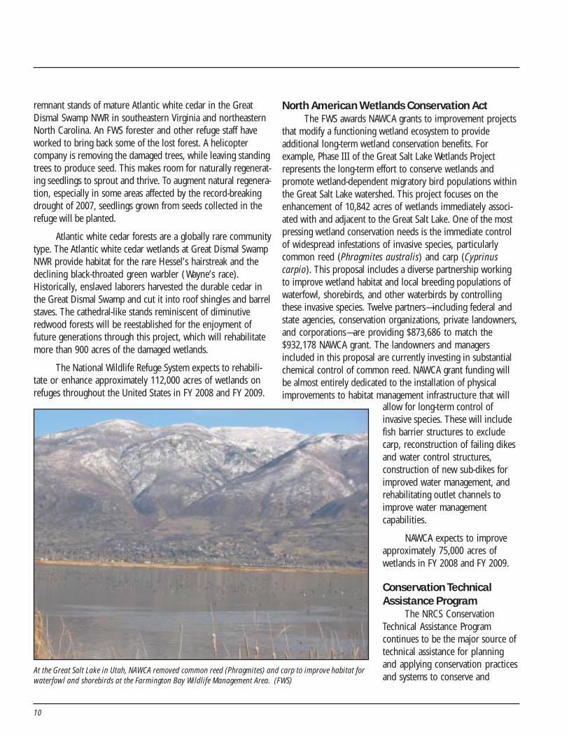
North American Wetlands Conservation ActThe FWS awards NAWCA grants to improvement projects
that modify a functioning wetland ecosystem to provideadditional long-term wetland conservation benefits. Forexample, Phase III of the Great Salt Lake Wetlands Projectrepresents the long-term effort to conserve wetlands andpromote wetland-dependent migratory bird populations withinthe Great Salt Lake watershed. This project focuses on theenhancement of 10,842 acres of wetlands immediately associ-ated with and adjacent to the Great Salt Lake. One of the mostpressing wetland conservation needs is the immediate controlof widespread infestations of invasive species, particularlycommon reed (Phragmites australis) and carp (Cyprinuscarpio). This proposal includes a diverse partnership workingto improve wetland habitat and local breeding populations ofwaterfowl, shorebirds, and other waterbirds by controllingthese invasive species. Twelve partners—including federal andstate agencies, conservation organizations, private landowners,and corporations—are providing $873,686 to match the$932,178 NAWCA grant. The landowners and managersincluded in this proposal are currently investing in substantialchemical control of common reed. NAWCA grant funding willbe almost entirely dedicated to the installation of physicalimprovements to habitat management infrastructure that will
allow for long-term control ofinvasive species. These will includefish barrier structures to excludecarp, reconstruction of failing dikesand water control structures,construction of new sub-dikes forimproved water management, andrehabilitating outlet channels toimprove water managementcapabilities.
NAWCA expects to improveapproximately 75,000 acres ofwetlands in FY 2008 and FY 2009.
Conservation TechnicalAssistance Program
The NRCS ConservationTechnical Assistance Programcontinues to be the major source oftechnical assistance for planningand applying conservation practicesand systems to conserve and
At the Great Salt Lake in Utah, NAWCA removed common reed (Phragmites) and carp to improve habitat forwaterfowl and shorebirds at the Farmington Bay Wildlife Management Area. (FWS)
11
enhance natural resources on non-federal land. These conservationactions deliver public benefits in theform of better soil quality, reduceddelivery of sediment and nutrients tosurface and ground waters, increasedconservation of water supplies,healthier grazing and forest landecosystems, diverse and healthierwildlife habitat, and improvedwetlands condition and function.
The Conservation TechnicalAssistance Program expects toimprove approximately 34,000 acresof wetlands in FY 2008 and FY 2009.
Coastal Wetlands Planning,Protection and RestorationAct (CWPPRA) Projects inLouisiana
The Coastal Wetlands Planning,
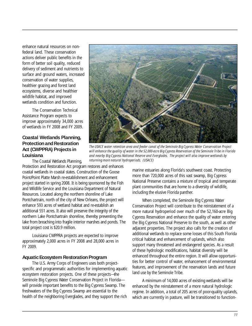
marine estuaries along Florida’s southwest coast. Protectingmore than 720,000 acres of this vast swamp, Big CypressNational Preserve contains a mixture of tropical and temperateplant communities that are home to a diversity of wildlife,including the elusive Florida panther.
When completed, the Seminole Big Cypress WaterConservation Project will contribute to the reinstatement of amore natural hydroperiod over much of the 52,160-acre BigCypress Reservation and enhance the quality of water enteringthe Big Cypress National Preserve to the south, as well as otheradjacent properties. The project also calls for the creation ofadditional wetlands to replace some losses of this South Floridacritical habitat and enhancement of uplands, which alsosupport many threatened and endangered species. As a resultof these hydrologic modifications, habitat diversity will beenhanced throughout the entire region. It will allow opportuni-ties for better control of water, enhancement of environmentalfeatures, and improvement of the reservation lands and futureland use by the Seminole Tribe.
A minimum of 14,000 acres of existing wetlands will beenhanced by the reinstatement of a more natural hydrologicregime. In addition, a total of 205 acres of poor-quality uplands,which are currently in pasture, will be transitioned to function-
Protection and Restoration Act program restores and enhancescoastal wetlands in coastal states. Construction of the GoosePoint/Point Platte Marsh re-establishment and enhancementproject started in spring 2008. It is being sponsored by the Fishand Wildlife Service and the Louisiana Department of NaturalResources. Located along the northern shoreline of LakePontchartrain, north of the city of New Orleans, the project willenhance 593 acres of wetland habitat and re-establish anadditional 551 acres. It also will preserve the integrity of thenorthern Lake Pontchartrain shoreline, thereby preventing thelake from breaching into fragile interior marshes and ponds. Thetotal project cost is $20.9 million.
Louisiana CWPPRA projects are expected to improveapproximately 2,000 acres in FY 2008 and 28,000 acres inFY 2009.
Aquatic Ecosystem Restoration ProgramThe U.S. Army Corps of Engineers uses both project-
specific and programmatic authorities for implementing aquaticecosystem restoration projects. One of these projects—theSeminole Big Cypress Water Conservation Project in Florida—will provide important benefits to the Big Cypress Swamp. Thefreshwaters of the Big Cypress Swamp are essential to thehealth of the neighboring Everglades, and they support the rich
The USACE water retention area and feeder canal of the Seminole Big Cypress Water Conservation Projectwill enhance the quality of water in the 52,000-acre Big Cypress Reservation of the Seminole Tribe in Floridaand nearby Big Cypress National Reserve and Everglades. The project will also improve wetlands byreturning more natural hydroperiods. (USACE)
5 - Aquatic Ecosystem
12
ing wetland habitat. The establish-ment of water retention cells totaling656 acres will aid in control offlooding throughout the Reservationand provide much-needed water forirrigation during periods of drought.
This project is designed toimprove the quality of water and runofffrom all phosphorus-generatingagricultural sources within thereservation. A phosphorus level of 50ppb is the goal, which is the currentperformance level designed for thestormwater treatment areas. Shoulddesign performance levels for phos-phorus become more stringent, theproject is designed to incorporateadditional alternative technology tomeet stricter levels.
The Aquatic EcosystemRestoration Program expects toimprove approximately 2,000 acres ofwetlands in FY 2008 and 16,000 acres
Joint Ventures expect to improve approximately 16,000acres of wetlands in FY 2008 and 13,000 acres in FY 2009.
Protect Wetlands
After Four Years of Accomplishment: 1,324,000 acresEstimated Accomplishment Earth Day 2009: 376,000 acres(totals adjusted for double-counting )
Priority wetlands are protected from activities that mayimperil their existence or condition. In this report, protectionrefers to acquisition of land or easements of at least 30 years.Because protection maintains the base of existing wetlands, itdoes not result in a gain of wetland acres or function.
During the first four years (April 2004 through April2008), federal agencies reported protecting 1,324,000 acres ofexisting wetlands. By Earth Day 2009, federal agencies plan toprotect an additional 376,000 acres of wetlands.
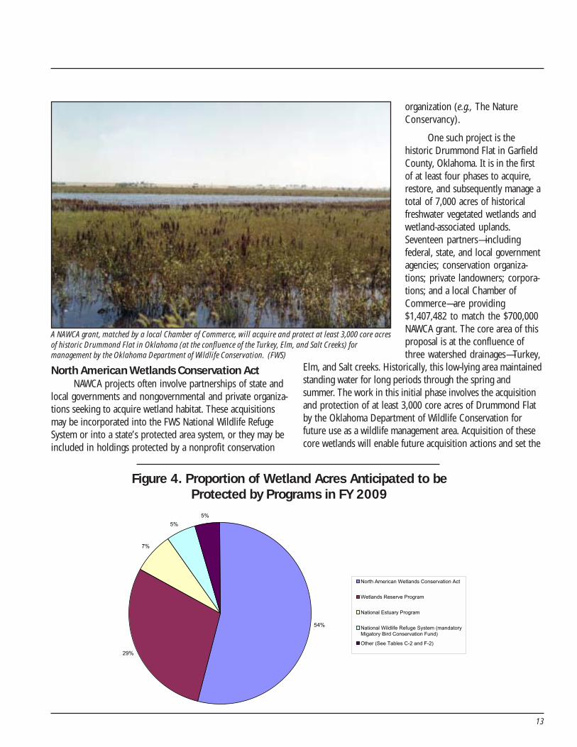
The major programs planning wetland protection inFY 2009 are the North American Wetlands Conservation Act,Wetlands Reserve Program, National Estuary Program, andNational Wildlife Refuge System’s Migratory Bird ConservationFund program (Figure 4).
in FY 2009.
North American Waterfowl Management Plan–Joint Ventures
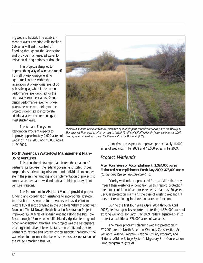
This tri-national strategic plan fosters the creation ofpartnerships between the federal government, states, tribes,corporations, private organizations, and individuals to cooper-ate in the planning, funding, and implementation of projects toconserve and enhance wetland habitat in high-priority “jointventure” regions.
The Intermountain West Joint Venture provided projectfunding and coordination assistance to incorporate strategicbird habitat conservation into a watershed-based effort torestore fluvial arctic grayling in the Big Hole Valley of southwestMontana. The McDowell Reach Riparian Restoration Projectimproved 1,200 acres of riparian wetlands along the Big HoleRiver through 12 miles of wildlife-friendly riparian fencing andother rehabilitation activities. The project was the centerpieceof a larger initiative of federal, state, non-profit, and privatepartners to restore and protect critical habitats throughout thewatershed in a manner that benefits the livestock operations ofthe Valley’s ranching families.
The Intermountain West Joint Venture, composed of multiple partners under the North American WaterfowlManagement Plan, worked with ranchers to install 12 miles of wildlife-friendly fencing to improve 1,200acres of riparian wetlands along the Big Hole River in Montana. (FWS)
13
North American Wetlands Conservation ActNAWCA projects often involve partnerships of state and
local governments and nongovernmental and private organiza-tions seeking to acquire wetland habitat. These acquisitionsmay be incorporated into the FWS National Wildlife RefugeSystem or into a state’s protected area system, or they may beincluded in holdings protected by a nonprofit conservation
organization (e.g., The NatureConservancy).
One such project is thehistoric Drummond Flat in GarfieldCounty, Oklahoma. It is in the firstof at least four phases to acquire,restore, and subsequently manage atotal of 7,000 acres of historicalfreshwater vegetated wetlands andwetland-associated uplands.Seventeen partners—includingfederal, state, and local governmentagencies; conservation organiza-tions; private landowners; corpora-tions; and a local Chamber ofCommerce—are providing$1,407,482 to match the $700,000NAWCA grant. The core area of thisproposal is at the confluence ofthree watershed drainages—Turkey,
Elm, and Salt creeks. Historically, this low-lying area maintainedstanding water for long periods through the spring andsummer. The work in this initial phase involves the acquisitionand protection of at least 3,000 core acres of Drummond Flatby the Oklahoma Department of Wildlife Conservation forfuture use as a wildlife management area. Acquisition of thesecore wetlands will enable future acquisition actions and set the
Figure 4. Proportion of Wetland Acres Anticipated to beProtected by Programs in FY 2009
54%
29%
7%
5%
5%
North American Wetlands Conservation Act
Wetlands Reserve Program
National Estuary Program
National Wildlife Refuge System (mandatoryMigatory Bird Conservation Fund)
Other (See Tables C-2 and F-2)
A NAWCA grant, matched by a local Chamber of Commerce, will acquire and protect at least 3,000 core acresof historic Drummond Flat in Oklahoma (at the confluence of the Turkey, Elm, and Salt Creeks) formanagement by the Oklahoma Department of Wildlife Conservation. (FWS)
14
stage for the restoration of historicwetland values in a region wherelimited habitat is heavily used bymigratory waterfowl, shorebirds, andwading birds and other wildlife.
NAWCA expects to protectapproximately 227,000 acres ofwetlands in FY 2008 and FY 2009.
Wetlands Reserve ProgramNRCS is especially proud of the
partnership efforts that have beengenerated as a result of thisprogram’s activities. Restoration oftwo Wetlands Reserve Programeasements in 2007 owned by TwinOaks Land Company in WinnebagoCounty, Iowa, have not only restoredand enhanced wetlands and wildlifeto the local area, but are serving as awater quality filter for area farmers.The easements, totaling over 300 acres, comprise nearly 120acres of wetland soils that have been restored and/or enhanced.Of those acres, 50 acres will offer a natural filter to six drainagetile lines. The lines were brought to the surface so the wetlandscould filter out any sediments, nutrients, and contaminantsfrom surrounding farmland before entering the drainagesystem downstream.
The Wetlands Reserve Program expects to protectapproximately 100,000 acres of wetlands in FY 2008 and anadditional 122,000 acres in FY 2009.
National Estuary ProgramAt the 28 National Estuary Program (NEP) sites around the
country, local stakeholders work together to identify and prioritizethe problems in their estuaries. NEP community stakeholdersinclude citizens; educators; government representatives at thestate, local, and federal levels; environmental advocates; businessleaders; scientists; farmers; and people who fish. Each communitydevelops and implements a Comprehensive Conservation andManagement Plan with specific actions designed to protect theestuary and its resources. The plan addresses all aspects ofenvironmental conservation for the estuary, including waterquality, habitat, living resources, and land use practices, whichleads to restoration/creation, improvement, and protectionactivities including land protection and acquisition projects.
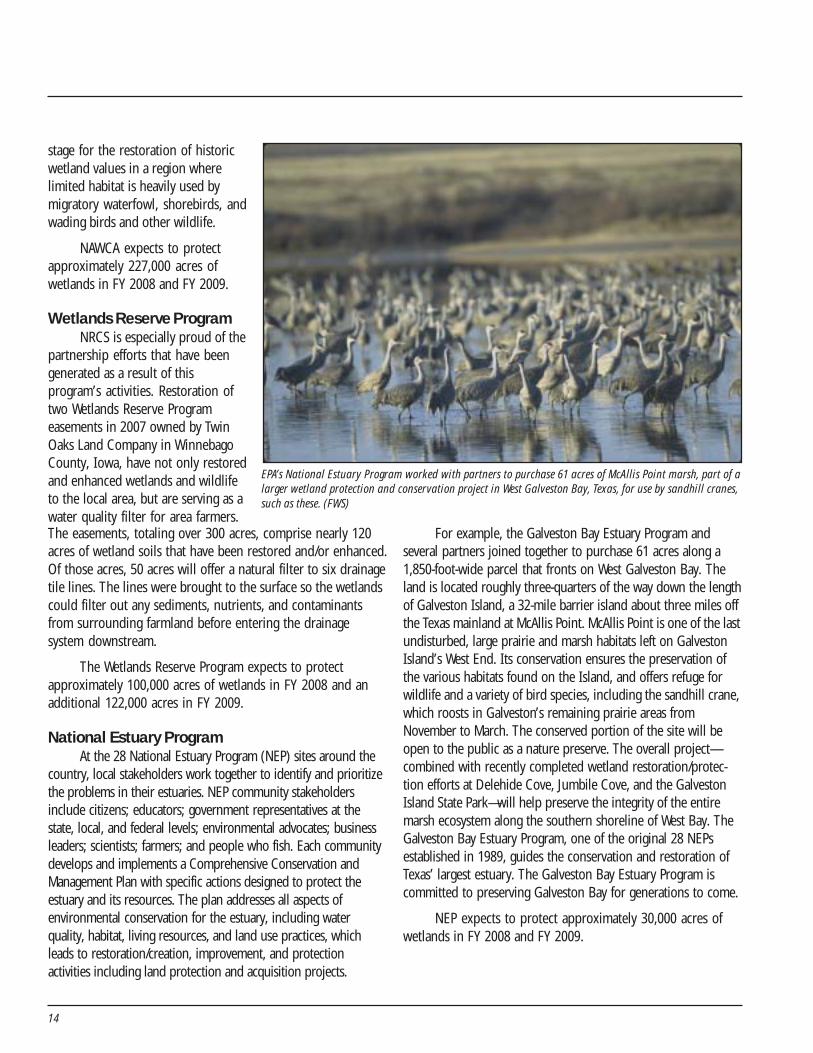
For example, the Galveston Bay Estuary Program andseveral partners joined together to purchase 61 acres along a1,850-foot-wide parcel that fronts on West Galveston Bay. Theland is located roughly three-quarters of the way down the lengthof Galveston Island, a 32-mile barrier island about three miles offthe Texas mainland at McAllis Point. McAllis Point is one of the lastundisturbed, large prairie and marsh habitats left on GalvestonIsland’s West End. Its conservation ensures the preservation ofthe various habitats found on the Island, and offers refuge forwildlife and a variety of bird species, including the sandhill crane,which roosts in Galveston’s remaining prairie areas fromNovember to March. The conserved portion of the site will beopen to the public as a nature preserve. The overall project—combined with recently completed wetland restoration/protec-tion efforts at Delehide Cove, Jumbile Cove, and the GalvestonIsland State Park—will help preserve the integrity of the entiremarsh ecosystem along the southern shoreline of West Bay. TheGalveston Bay Estuary Program, one of the original 28 NEPsestablished in 1989, guides the conservation and restoration ofTexas’ largest estuary. The Galveston Bay Estuary Program iscommitted to preserving Galveston Bay for generations to come.
NEP expects to protect approximately 30,000 acres ofwetlands in FY 2008 and FY 2009.
EPA’s National Estuary Program worked with partners to purchase 61 acres of McAllis Point marsh, part of alarger wetland protection and conservation project in West Galveston Bay, Texas, for use by sandhill cranes,such as these. (FWS)
15
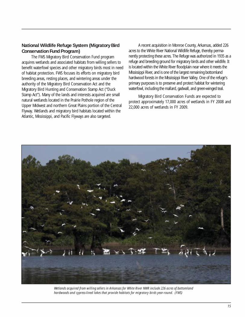
National Wildlife Refuge System (Migratory BirdConservation Fund Program)
The FWS Migratory Bird Conservation Fund programacquires wetlands and associated habitats from willing sellers tobenefit waterfowl species and other migratory birds most in needof habitat protection. FWS focuses its efforts on migratory birdbreeding areas, resting places, and wintering areas under theauthority of the Migratory Bird Conservation Act and theMigratory Bird Hunting and Conservation Stamp Act (“DuckStamp Act”). Many of the lands and interests acquired are smallnatural wetlands located in the Prairie Pothole region of theUpper Midwest and northern Great Plains portion of the CentralFlyway. Wetlands and migratory bird habitats located within theAtlantic, Mississippi, and Pacific Flyways are also targeted.
A recent acquisition in Monroe County, Arkansas, added 226acres to the White River National Wildlife Refuge, thereby perma-nently protecting these acres. The Refuge was authorized in 1935 as arefuge and breeding ground for migratory birds and other wildlife. Itis located within the White River floodplain near where it meets theMississippi River, and is one of the largest remaining bottomlandhardwood forests in the Mississippi River Valley. One of the refuge’sprimary purposes is to preserve and protect habitat for winteringwaterfowl, including the mallard, gadwall, and green-winged teal.
Migratory Bird Conservation Funds are expected toprotect approximately 17,000 acres of wetlands in FY 2008 and22,000 acres of wetlands in FY 2009.
Wetlands acquired from willing sellers in Arkansas for White River NWR include 226 acres of bottomlandhardwoods and cypress-lined lakes that provide habitats for migratory birds year-round. (FWS)

16
17
Perspective
Federal agencies have accomplished the acreage targets ofthe President’s five-year goal in four years—a full yearahead of schedule. Each of the agencies developed
creative solutions, with particular emphasis on public–privatepartnerships and cooperative conservation. These partnershipsinvolve federal, state, and local governments; corporations; awide range of nongovernmental conservation organizations;and, in many cases, individuals.
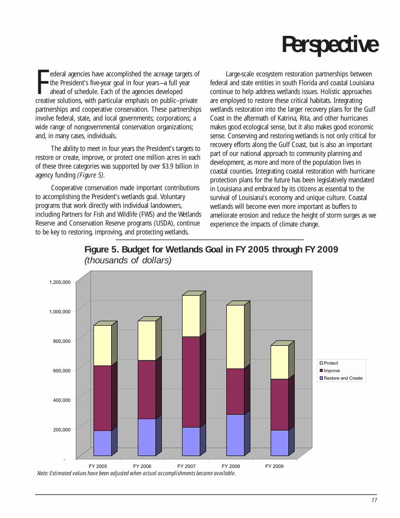
The ability to meet in four years the President’s targets torestore or create, improve, or protect one million acres in eachof these three categories was supported by over $3.9 billion inagency funding (Figure 5).
Cooperative conservation made important contributionsto accomplishing the President’s wetlands goal. Voluntaryprograms that work directly with individual landowners,including Partners for Fish and Wildlife (FWS) and the WetlandsReserve and Conservation Reserve programs (USDA), continueto be key to restoring, improving, and protecting wetlands.
Large-scale ecosystem restoration partnerships betweenfederal and state entities in south Florida and coastal Louisianacontinue to help address wetlands issues. Holistic approachesare employed to restore these critical habitats. Integratingwetlands restoration into the larger recovery plans for the GulfCoast in the aftermath of Katrina, Rita, and other hurricanesmakes good ecological sense, but it also makes good economicsense. Conserving and restoring wetlands is not only critical forrecovery efforts along the Gulf Coast, but is also an importantpart of our national approach to community planning anddevelopment, as more and more of the population lives incoastal counties. Integrating coastal restoration with hurricaneprotection plans for the future has been legislatively mandatedin Louisiana and embraced by its citizens as essential to thesurvival of Louisiana’s economy and unique culture. Coastalwetlands will become even more important as buffers toameliorate erosion and reduce the height of storm surges as weexperience the impacts of climate change.
-
200,000
400,000
600,000
800,000
1,000,000
1,200,000
FY 2005 FY 2006 FY 2007 FY 2008 FY 2009
Protect
Improve
Restore and Create
Figure 5. Budget for Wetlands Goal in FY 2005 through FY 2009(thousands of dollars)
Note: Estimated values have been adjusted when actual accomplishments became available.
18
The Energy Policy Act of 2005, through its Coastal ImpactAssistance Program (CIAP) section 384, may provide $250million in each fiscal year from 2007 through 2010 to eligiblecoastal states and their coastal political subdivisions forprojects and activities to: protect, restore, or conserve coastalareas, including wetlands; mitigate damage to natural habitats;administer the program; implemental federally approvedmarine, coastal, or comprehensive conservation managementplans; and mitigate the impact of Outer Continental Shelfactivities through funding of onshore infrastructure projectsand public service needs. A maximum of 23 percent of thefunds can be spent on two of those uses—administration of theprogram and mitigation of Outer Continental Shelf activities. InNovember 2007, DOI’s Minerals Management Service approvedLouisiana’s CIAP State Plan, making Louisiana the first eligiblecoastal state to receive federal approval under this program.Louisiana’s Plan is dominated by wetland restoration andconservation projects and programs, such as creating marsheswith dredged material, restoring Mississippi River inflows intoadjacent wetlands, protecting and restoring barrier and interiorshorelines that help protect adjacent wetlands, and conservingcoastal forests.
Increased federal attention to wetlands efforts hasheightened public awareness of the importance of wetlandsand their role in sustaining a resilient coast. The devastatinghurricanes of 2005 have served to increase the sense ofurgency among the American public for conserving, restoring,and creating coastal wetlands. An informed public working inpartnership with federal, state, tribal, and local agenciesprovides an opportunity to ensure wetlands are conserved forfuture generations.
These cooperative conservation and stewardship effortsdepend on accurate, timely, and reliable data that provide acommon working map of where restoration efforts have beenrealized, are in progress, or need to be initiated. Although theNational Wetlands Inventory and National Resources Inventoryprovide a base of information for this purpose, an integratednational, regional, and local information system to capture,manage, and share the site information on restoration effortswould improve the value of this information for decisionmakers. This system could provide real-time access to informa-tion that can be viewed and validated by a community ofpartners in the context of map location, landscape position,and focus areas.
To satisfy these require-ments, the system must begeospatially enabled withgeographic informationsystems (GIS) technology andit must take advantage of thepower of the Internet forpromoting collaboration. Sucha system could significantlyimprove the tracking ofaccomplishments, managementof data, dissemination ofinformation, environmentalanalyses, and decision making.Progress toward the President’swetlands goal was estimatedusing the best means available,but this was a challengebecause of weaknesses in thereporting system that requiredan adjustment for over-reporting of acreage resultingfrom partnerships and sharedresponsibilities. We can
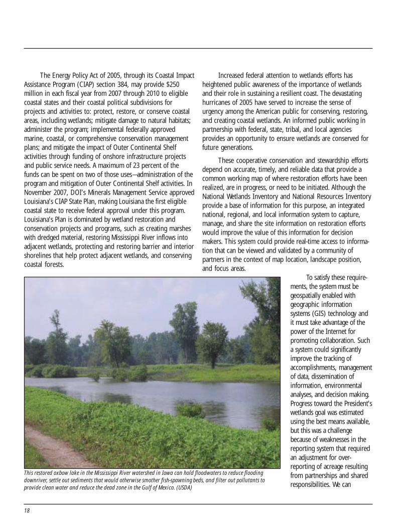
This restored oxbow lake in the Mississippi River watershed in Iowa can hold floodwaters to reduce floodingdownriver, settle out sediments that would otherwise smother fish-spawning beds, and filter out pollutants toprovide clean water and reduce the dead zone in the Gulf of Mexico. (USDA)
19
significantly improve the reporting system and move forwardfrom estimating accomplishments to measuring them through theuse of GIS technology. A proof-of-concept project has beenfunded by the Environmental Protection Agency (see Trackingand Sharing Wetlands Restoration, Creation, and ImprovementData Using GIS, page 24).
Such a system will allow state and federal agencies andprivate sector partners to share GIS-based information concern-ing wetlands using national and international standards-basedsolutions. Decision makers and managers at all levels inside andoutside the government will be able to make better-informed andmore timely wetland decisions. We are making progress in linkingand publishing data for the public and for partner agencies. TheNational Wetland Inventory now delivers mapped wetland datafor 56 percent of the nation in real time over the Internet to theU.S. Army Corps of Engineers wetland permit tracking system andthe FWS Environmental Conservation Online System (ECOS).Almost 44 million users viewed, printed, or downloaded wetlandsdata through the FWS state-of-the-art Wetlands Mapper with its
array of analytical tools. For citizen access, National WetlandsInventory data are now also viewable through Google Earth.Through expanded use of standards-based web services, FWS ispromoting on-demand access to current wetlands informationfor decision support.
Last year, we correctly estimated that we would achievewetlands acreage targets of the President’s Earth Day 2004 goala year earlier than our target date of Earth Day 2009. To ensurethat the strides made not only continue, but increase, decisionmakers and individual citizens should have browser-basedaccess to the information they need to track past accomplish-ments and make decisions that leverage our limited resourcesto protect and enhance our nation’s wetlands. As we strive toincrease both the quantity and quality of wetlands while facingthe challenges of environmental changes, we know the successof this endeavor lies with public–private partnerships and thesupport of Congress and the American public.
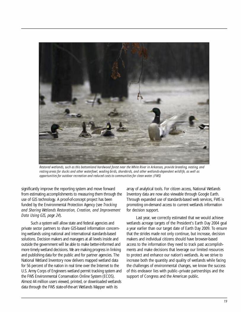
Restored wetlands, such as this bottomland hardwood forest near the White River in Arkansas, provide breeding, nesting, andresting areas for ducks and other waterfowl, wading birds, shorebirds, and other wetlands-dependent wildlife, as well asopportunities for outdoor recreation and reduced costs to communities for clean water. (FWS)

20
21
Appendix A.Methodology and Definitions
Data Call to the AgenciesThe data call for wetlands performance and budget data
went to the Departments of Agriculture, Army, Commerce, theInterior, and Transportation and to the Environmental Protec-tion Agency. The Working Group improved interagencyguidance based on lessons learned last year. The guidanceincreased the consistency and accuracy of the estimatesdeveloped.
Reporting PeriodPerformance and funding data for programs covered the
following time periods:
• FY 2007 actual budget and performance results• FY 2008 enacted budget and estimated performance
results• FY 2009 President’s requested budget and estimated
performance results.To assess progress for the fourth year since the President’s
April 2004 announcement, half of the reported achievements forFY 2007 were combined with half of the planned accomplish-ments for FY 2008. Projected estimates in the previous reportwere adjusted using actual results for FY 2007.
Year Performance and Budget DataReported
Performance data are reported in the year the project iscompleted, land acquired, or easement purchased. However,funding is reported in the year it is appropriated. For example,funding for a multi-year wetlands improvement project wouldbe reported in FY 2007 and FY 2008 when funding is appropri-ated, but the number of acres improved would be accrued inFY 2009 and FY 2010 as the accomplishments are realized.
Scope of Funding Included in the ReportWetlands activities funded by both discretionary and
mandatory funds are included. Discretionary funds arecontrolled by appropriations acts, and mandatory funds arecontrolled by laws other than appropriations acts (e.g., CoastalWetlands Planning, Protection, and Restoration Act funds, andfunds collected from the sale of Migratory Bird ConservationStamps [“Duck Stamps”]). All annually appropriated funds are
considered to be discretionary funds. The funding amountsidentified in this report are estimates that were available at thetime the President’s FY 2009 Budget Request was presented toCongress. For future reports, estimates should be adjustedbased on enacted budgets.
Definitions of AccomplishmentsIn 2000, the White House Wetlands Working Group
( WHWWG)—composed of representatives from all majorfederal agencies involved in wetlands work—agreed to usewetlands terminology and definitions that had been developedduring the mid-1990s. Information was provided by theparticipating agencies using terminology similar to that previ-ously developed by the WHWWG and the same terminologyused in previous Earth Day wetlands reports.
To “restore or create” wetlands results in a gain ofwetland acres and includes:
• Creation of wetlands that did not previously exist onan upland or deepwater site. These actions arereferred to as “establishment” by the WHWWG.
• Restoration of a former wetland to its natural/historicfunction and resulting value. Typically, such a formerwetland had been drained for some purpose. Theseactions are known as “re-establishment” by theWHWWG.
To “improve” wetlands results in a gain of wetlandsfunctions or quality, rather than additional acreage, and includes:
• Repair of the natural/historic functions and associatedvalues of a degraded wetland. The WHWWG refers tothese actions as “rehabilitation” of wetlands. Rehabili-tation results in a gain in wetlands quality.
• Heightening, intensification, or improvement of one ormore selected functions and associated values. TheWHWWG called these types of actions “enhancement.”Enhancement is undertaken for a purpose such aswater quality improvement, flood water retention, orwildlife habitat. Enhancement results in the gain ofselected wetland functions and associated values butmay also lead to a decline in other wetland functionsand values.
To “protect” wetlands includes acquisition of land oreasements of at least 30 years’ duration.
22
Limitations to Activities Counted towardthe President’s Goal
Wetlands onlyPrograms that perform both wetlands activities and non-
wetlands activities reported funding and performance relatedonly to the wetlands component, not their entire program. Forexample, when land is purchased for waterfowl management itmay include both wetlands and associated upland nestingcover. These upland acres were deducted from the acresreported as contributing to the President’s wetlands goal, andthe cost of these acres was generally deducted from the fundsexpended for the project. The number of acres of wetlandscontributed by a program to the President’s wetlands goal willbe smaller than the number of habitat acres reported in otherbudget documents because the habitat acres typically includeupland buffer strips, associated upland cover, and nestingislands.
Eradication and abatement activities in wetlandsThe first year an invasive plant or animal is eradicated or
its population abated, the acreage will be reported as a gainunder “improve.” Additional eradication or abatement work onthe same area is considered to be maintenance and is notcounted in the improve category.
Winter flooding of agricultural landsWhether this acreage is counted depends on (1) whether
the land is wetland or upland before the flooding and (2)whether the land is being newly flooded or the land is within afootprint that has been flooded in past winters. If the field isupland before being artificially flooded during the winter andupland after the water is removed in the spring, the acres arenot counted. If the field is a farmed wetland before the floodingand this is the first year the field has been flooded, the acres arecounted. Subsequent years of winter flooding are consideredmanagement and are not counted. The first year the acreagewill be reported as an improvement in quality through enhance-ment, because adding winter water results in the improvementof wildlife habitat. Farmed wetlands are defined as areas wherethe soil surface has been mechanically or physically altered forproduction of crops, but hydrophytes will become establishedif farming is discontinued.
Accomplishments outside the United StatesDue to the migratory nature of birds, some programs
work to restore, improve, and protect wetlands in Canada,Mexico, and the Caribbean. International portions of programswere not included in the data reported.
Uplands workMany programs carry out activities in upland areas that are
crucial to the health and sustainability of wetlands. These uplandacres were not counted toward the President’s wetlands goal.
Wetland Conservation On-the-GroundActivities That Maintain the Nation’sWetland Base
Many important on-the-ground wetland activities are notcounted toward meeting the President’s goal because they arefocused on maintaining or managing the nation’s wetlands baseand do not add acres, increase wetland quality, or fall withinthe definition of “protect.” Many agencies spend far more fundsmaintaining and managing the existing wetlands base than theydo making additions to the base. The base is critically impor-tant, because wetland gains can only be built on a stablefoundation. Other activities that help sustain the wetlands baseare included in Appendix B, Conserving Wetlands.
Cyclical workThis work is carried out to sustain wetlands (e.g., habitat
maintenance on a National Wildlife Refuge to maximize wetlandhabitat values). Cyclic water-level management and other cyclicwetland activities are used to mimic naturally occurring floodregimes for the benefit of wildlife. Only new activities on afootprint of wetlands not previously manipulated for increasedvalue were counted in the “improved” category as rehabilita-tion or an enhancement.
Management and maintenance activitiesEffective management and maintenance activities are
critical to sustain wildlife and plant populations. Managementactivities involve periodic manipulation of the physical,chemical, or biological characteristics critical to maintaininghabitat quality. These manipulations mimic natural regimesthrough periodic flooding, mowing, or prescribed burns.Maintenance activities include the repair of water controlstructures, fences, or structural protection. Cessation ofmanagement and maintenance activities triggers loss in targeted
23
wetland values. Maintenance activities do not result in anincrease in wetlands acreage or quality.
Compensatory mitigationWetlands created or improved as mitigation for the loss
or degradation of other wetland values are not counted towardthe President’s goal. Programs that provide compensatorymitigation for wetland losses are not counted as contributing tothe new wetlands goal because they maintain the nation’swetlands base. Examples of these types of programs are theFederal Highway Administration programs that mitigate theimpacts of highways on wetlands, the Clean Water Act provi-sions that require the mitigation of permitted wetland losses,and the Natural Resources Damage Assessment and RestorationProgram, which restores and improves wetlands at formerhazardous waste sites.
Shoreline stabilizationThe preservation of a marsh or channel using shoreline
stabilization techniques (e.g., rock revetments, or steel orplastic sheet pile protection) is called armored or hard shore-line stabilization. Partial preservation from shoreline erosionusing vegetative plantings is called soft shoreline protection.Shoreline stabilization prevents loss of wetland acreage due tosubsidence; erosion by tides, wind, and boat traffic; and similarfactors. Because it does not increase the quantity or quality ofwetlands and does not meet the definition of protect, thisacreage is not counted toward the President’s goal.
Correcting for Over-Reporting of AcreageMore and more programs are participating in cooperative
conservation partnerships. They have proven to be effectiveand efficient mechanisms to leverage resources and expertise.Many programs work cooperatively with both internal andexternal federal partners as well as non-federal partners.Correcting for over-reporting of acreage is a challenge toaccurately reporting accomplishments. One partner mayprovide materials and equipment, another labor, anothertechnical assistance, and yet another land. For example, a 100-acre project with four partners could be reported by each ofthe partners, and could appear to be 400 acres when com-bined. In some cases, one partner may not be aware that alandowner is working with multiple partners.
These partnerships may result in over-reporting ofperformance. To correct for this “double-counting,” partner-
ship worksheets were used. Programs were asked to identifypartnership groups separately on the worksheets. Someagencies do not collect partnership data, and of those that do,most do not collect this data to the level of detail necessary tomake refined adjustments for double-counting. Although all theperformance data was accounted for on the partnershipworksheets, the resolution was not sufficient to make adjust-ments to individual program accomplishments. Therefore, anoverarching correction was necessary to avoid over-reportingthe acres created or restored, improved, and protected.
To calculate this double-counting adjustment, all theacreage reported as accomplished through federal partnershipswas summed by category. The calculation assumed two federalpartners were involved in situations where at least one addi-tional federal partner was reported by the reporting agency.Half of the total acreage accomplished through multiple federalpartnerships by category was subtracted from the raw total, bycategory. The partnership adjustment for FY 2008 was used forFY 2009.
Moving Toward a PerformanceMeasurement and Tracking System
This document reflects the lessons learned in developingthe progress reports over the past four years. Over-reportingdue to partnerships remains a significant concern. The consen-sus is that the best solution to the problem would involve theuse of geographic information system (GIS) technology orother geo-enabled technologies.
The use of GIS technology to track wetland programs andtheir contribution toward the national goal would simplify theproblem of adjusting for double-counting. The digital projectboundaries could be entered into a GIS, analyzed for multipleoverlaps, and overlaid on a digital map of the United States. Themap would facilitate the development of monitoring programsto ensure wetlands are restored, improved, and protected andthat they provide the intended functions and values.
Tracking systems require agreement on common perfor-mance measures and definitions. The definitions in this reporthave been in place since the mid-1990s. A proof-of-conceptproject has been funded by the Environmental ProtectionAgency (see Tracking and Sharing Wetlands Restoration,Creation, and Improvement Data Using GIS).
24
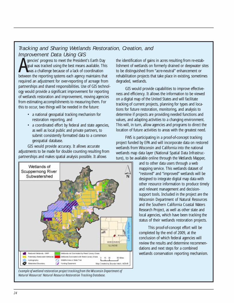
Tracking and Sharing Wetlands Restoration, Creation, andImprovement Data Using GIS
Agencies’ progress to meet the President’s Earth Daygoal was tracked using the best means available. This was a challenge because of a lack of coordination
between the reporting systems each agency maintains thatrequired an adjustment for over-reporting of acreage frompartnerships and shared responsibilities. Use of GIS technol-ogy would provide a significant improvement for reportingof wetlands restoration and improvement, moving agenciesfrom estimating accomplishments to measuring them. Forthis to occur, two things will be needed in the future:
• a national geospatial tracking mechanism forrestoration reporting, and
• a coordinated effort by federal and state agencies,as well as local public and private partners, tosubmit consistently formatted data to a commongeospatial database.
GIS would provide accuracy. It allows accurateadjustments to be made for double counting resulting frompartnerships and makes spatial analysis possible. It allows
the identification of gains in acres resulting from re-estab-lishment of wetlands on formerly drained or deepwater sitesto be distinguished from “acre-neutral” enhancement orrehabilitation projects that take place in existing, sometimesdegraded, wetlands.
GIS would provide capabilities to improve effective-ness and efficiency. It allows the information to be viewedon a digital map of the United States and will facilitatetracking of current projects, planning for types and loca-tions for future restoration, monitoring, and analysis todetermine if projects are providing needed functions andvalues, and adapting activities to a changing environment.This will, in turn, allow agencies and programs to direct thelocation of future activities to areas with the greatest need.
FWS is participating in a proof-of-concept trackingproject funded by EPA and will incorporate data on restoredwetlands from Wisconsin and California into the nationalwetlands map data layer (National Spatial Data Infrastruc-ture), to be available online through the Wetlands Mapper,
Example of wetland restoration project tracking from the Wisconsin Department ofNatural Resources’ Natural Resource Restoration Tracking Database.
and to other data users through a webmapping service. This wetlands dataset of“restored” and “improved” wetlands will bedesigned to integrate digital map data withother resource information to produce timelyand relevant management and decision-support tools. Included in the project are theWisconsin Department of Natural Resourcesand the Southern California Coastal WatersResearch Project, as well as other state andlocal agencies, which have been tracking thestatus of their wetlands restoration projects.
This proof-of-concept effort will becompleted by the end of 2009, at theconclusion of which federal agencies willreview the results and determine recommen-dations and next steps for a combinedwetlands conservation reporting mechanism.
25
Appendix B.Conserving Wetlands
Other Activities that Help Maintain theWetlands Base
Federal agencies engage in various actions that helpmaintain the existing base of wetlands. The President’s goalhelped sharpen focus on these activities. A policy of having an“overall increase” of wetlands must be built on a strongfoundation of “no net loss.” Key programs that contribute tothe base, but that are outside the President’s initiative, fall intothe following categories:
• Managing wetlands,• Cooperative conservation,• Regulation and mitigation,• Support activities.
Managing WetlandsApproximately 13 percent of the nation’s current base of
wetlands is managed by federal agencies. Many units of FWS’sNational Wildlife Refuge System were established for theirwetland values, and FWS spends approximately $25 millionannually to actively manage more than 1.1 million acres ofwetlands. Wetlands management activities include creatingdesired conditions through the use of canals, levees, watercontrol structures, and pumps. Cyclical water level andmanagement activities–including mechanical disturbance,prescribed burning, or chemical treatment–also are used toproduce native wildlife foods in wetlands. Other federalagencies managing wetlands include the National Park Service,U.S. Forest Service, Bureau of Land Management, NationalOceanic and Atmospheric Administration, Bureau of Reclama-tion, Bureau of Indian Affairs, and Department of Defense. Allof these wetlands are being conserved for sustainable benefits.
Cooperative ConservationSeventy-four percent of the land in the United States is
privately owned. To better conserve privately owned wetlands,the federal government relies on voluntary, incentive-basedconservation programs. For example, technical and financialassistance provided by the Natural Resources ConservationService and FWS help private landowners apply neededconservation techniques on their land. When private landown-ers use these programs to restore, protect, and improve
wetlands on their property, they serve as stewards of ourenvironment. Other cooperative conservation efforts include:
Public–private partnershipsThe success of federal actions to encourage and partner
with non-federal parties—including state and local governments,Indian tribes, and nongovernmental entities—increases opportu-nities to make progress through cooperative endeavors. Recenttrends are encouraging. For example, through Coastal America’sCorporate Wetland Restoration Partnership (CWRP), more than400 corporations, non-governmental organizations, and other
Coastal America and the CorporateWetlands Restoration Partnership
Throughout the four years of progress toward thePresident’s wetlands goal, interagency cooperation hasbeen highly effective in achieving results on the ground.Formalized cooperative processes, such as CWPPRA andthe FWS Joint Ventures, have played an important role, ashave informal cross-agency cooperative efforts such asCoastal America. Working on wetlands projects that spanmultiple federal agencies and programs, Coastal Americaserves as a facilitator and provides a virtual meeting placewhere multiple federal programs come together to workon projects of mutual interest.
The efficiencies gained through collaboration havenot been limited to federal agencies alone. ThroughCoastal America’s Corporate Wetlands RestorationPartnership (CWRP), more than 400 corporations, non-governmental organizations, and other partners contrib-uted to the President’s wetlands goal by providingmatching funds and in-kind services for wetlandsrestoration and protection projects. These CWRPmembers and partners helped leverage federal dollars forvital wetlands restoration projects throughout our nation(see http://www.coastalamerica.gov/text/cwrp.html). TheCWRP is expected to continue to grow over the nextseveral years. The coordinated use of such public–private wetlands restoration and protection effortsshould yield major ecological benefits.
26
partners contributed to the President’s wetlands goal by provid-ing matching funds and in-kind services for wetlands restorationand protection projects.
Another example of successful public–private partner-ships is the FWS Joint Ventures ( JVs). Formed to implement theNorth American Waterfowl Management Plan, they are self-directed partnerships involving federal, state, and localgovernments; corporations; and a wide range of nongovern-mental conservation organizations. JVs have proven to besuccessful tools for developing cooperative conservationefforts to protect waterfowl and other bird habitat. JVs addressmultiple local, regional, and continental goals for sustainingmigratory bird populations by developing scientifically basedhabitat projects that benefit waterfowl and other migratorybird populations.
Technical assistanceMost federal agencies involved with wetlands activities
provide federal, state, and local partners with technical(biological, engineering, hydrological, etc.) expertise to supportvarious development, conservation, and restoration projectsacross the country. These programs offer technical assistanceto help conserve, restore, and protect a variety of fish andwildlife and their habitats. Among the laws providing a founda-tion for technical assistance and conservation partnerships arethe Fish and Wildlife Coordination Act, National EnvironmentalPolicy Act, Clean Water Act, Federal Power Act, Estuary Restora-tion Act, and Environmental Restoration Act.
Regulation and Mitigation
Water qualityAn important aspect of the President’s Wetlands Initiative
is its continued emphasis on the goal of “no net loss” ofwetlands. Section 404 of the Clean Water Act regulates thedischarge of dredged or fill material into waters of the UnitedStates, including wetlands, and is jointly administered by theU.S. Army Corps of Engineers (USACE) and the EnvironmentalProtection Agency. The USACE has primary responsibility forday-to-day permitting of activities in jurisdictional “waters ofthe United States,” a broad category of aquatic resources thatincludes wetlands. A comprehensive permit review requiresapplicants to first avoid and then minimize impacts, and finallyuse compensatory mitigation to replace aquatic resourcefunctions lost. Regulated activities under this program includefills for development, water resource projects (such as dams
and levees), and infrastructure development. During the pastthree years, more than 260,000 permit applications wereprocessed requiring applicants to avoid impacts to more than21,000 acres of wetlands, and maintaining a ratio of more thantwo acres of mitigation for every acre of permitted impacts towetlands.
The USACE has recently converted to a new database andmanagement tool that allows it to better track project actions,including both impacts and compensatory mitigation. This toolalso includes a spatial database with maps supported by GIS,which facilitates a watershed approach for evaluation ofprojects. The USACE is currently working with its Federal, Stateand local partners, and the general public, to share data and toensure public accessibility to the system. The USACE and EPAhave recently promulgated a joint rule that proposes integratingthe watershed approach in mitigation planning. For moreinformation on the compensatory mitigation rule visit http://www.usace.army.mil/inet/functions/cw/cecwo/reg/ or http://www.epa.gov/wetlandsmitigation.
FarmlandThe Wetland Conservation (“Swampbuster”) provision
established in the 1985 Farm Bill, and amended in the 1990Farm Bill, requires all agricultural producers to protect thewetlands on the farms they own or operate if they wish to beeligible for certain USDA farm program benefits. Producers arenot eligible if they have planted an agricultural commodity on awetland that was converted by drainage, leveling, or any othermeans after December 23, 1985, or if they have converted awetland for the purpose of agricultural commodity production,or for making such production possible, after November 28,1990. NRCS Conservation Technical Assistance staff makewetlands determinations, develop wetlands mitigation andrestoration plans, and administer other Swampbuster-relatedprovisions.
TransportationUnder Federal Aid Highway legislation, state transportation
agencies may use national Highway System and Surface Transpor-tation Program funds to finance wetland and natural habitatconservation planning and implementation, as well as compensa-tory mitigation and restoration projects that offset unavoidablelosses from transportation projects. The Department of Transpor-tation has a goal of 1-to-1 wetland acre mitigation; under theFederal Aid Highway Program it has achieved more than 49,000acres of wetland mitigation since 1996, with mitigation exceeding
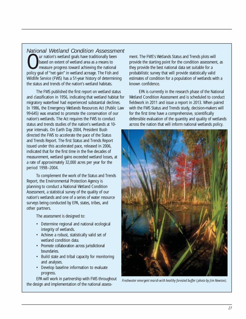
27
National Wetland Condition Assessment
Our nation’s wetland goals have traditionally beenbased on extent of wetland area as a means tomeasure progress toward achieving the national
policy goal of “net gain” in wetland acreage. The Fish andWildlife Service (FWS) has a 51-year history of determiningthe status and trends of the nation’s wetland habitats.
The FWS published the first report on wetland statusand classification in 1956, indicating that wetland habitat formigratory waterfowl had experienced substantial declines.In 1986, the Emergency Wetlands Resources Act (Public Law99-645) was enacted to promote the conservation of our
ment. The FWS’s Wetlands Status and Trends plots willprovide the starting point for the condition assessment, asthey provide the best national data set suitable for aprobabilistic survey that will provide statistically validestimates of condition for a population of wetlands with aknown confidence.
EPA is currently in the research phase of the NationalWetland Condition Assessment and is scheduled to conductfieldwork in 2011 and issue a report in 2013. When pairedwith the FWS Status and Trends study, decision-makers willfor the first time have a comprehensive, scientificallydefensible evaluation of the quantity and quality of wetlandsacross the nation that will inform national wetlands policy.
Freshwater emergent marsh with healthy forested buffer (photo by Jim Newton).
nation’s wetlands. The Act requires the FWS to conductstatus and trends studies of the nation’s wetlands at 10-year intervals. On Earth Day 2004, President Bushdirected the FWS to accelerate the pace of the Statusand Trends Report. The first Status and Trends Reportissued under this accelerated pace, released in 2006,indicated that for the first time in the five decades ofmeasurement, wetland gains exceeded wetland losses, ata rate of approximately 32,000 acres per year for theperiod 1998–2004.
To complement the work of the Status and TrendsReport, the Environmental Protection Agency isplanning to conduct a National Wetland ConditionAssessment, a statistical survey of the quality of ournation’s wetlands and one of a series of water resourcesurveys being conducted by EPA, states, tribes, andother partners.
The assessment is designed to:
• Determine regional and national ecologicalintegrity of wetlands.
• Achieve a robust, statistically valid set ofwetland condition data.
• Promote collaboration across jurisdictionalboundaries.
• Build state and tribal capacity for monitoringand analyses.
• Develop baseline information to evaluateprogress.
EPA will work in partnership with FWS throughoutthe design and implementation of the national assess-
28
acres affected by more than 31,000 acres. The 2005 Safe,Accountable, Flexible, Efficient Transportation Equity Act: ALegacy for Users requires that metropolitan and statewide plansreflect environmental mitigation and coordination with resourceagencies. The Federal Highway Administration also fundsresearch on wetlands mitigation in connection with highways,and wetlands mitigation is an eligible project cost for federaltransit and airport assistance.
Support Activities
Wetland mappingThe FWS strategically maps the nation’s wetlands and
deepwater habitats to gather information on their characteris-tics, extent, and status and trends through the NationalWetlands Inventory. The legislative mandates for the NationalWetlands Inventory come from the Emergency WetlandsResources Act (Public Law 99-645). OMB Circular A-16 alsodirects the FWS to build the wetlands layer of the NationalSpatial Data Infrastructure. The goal of the NWI is to produceinformation on the characteristics, extent, and status of thenation’s wetlands and deepwater and riparian habitats in orderto promote understanding and conservation of these re-sources. The program currently has wetland data for 56percent of the nation available on-demand and is updating onepercent per year. Wetlands data are used in planning foremerging conservation issues such as energy development,species population declines, and global climate change wherethey are used to model sea-level rise. The National WetlandsInventory is making progress in linking and publishing data forthe public and for partner agencies. The wetlands data areviewable and downloadable by anyone with a computer andaccess to the Internet through the Wetlands Mapper and theNational Map. The National Wetland Inventory also deliversmapped wetland data in real time over the Internet through itsweb mapping service, e.g., the U.S. Army Corps of Engineerswetland permit tracking system and the FWS EnvironmentalConservation Online System. For people with only a casualinterest in wetlands, National Wetlands Inventory data are alsoviewable through Google Earth. Through expanded use ofstandards-based web services, the Fish and Wildlife Service ispromoting access to current wetlands information for decisionsupport.http://www.fws.gov/nwi/
Wetland status and trends analysesThe Emergency Wetlands Resources Act of 1986 also
mandated that the Fish and Wildlife Service produce a report toCongress on the status and trends of the nation’s wetlands on a10-year cycle. As part of the President’s Wetlands Initiative, theFWS completed an updated national wetlands status and trendsreport in 2005. The study found that there are about 107.7million acres of wetlands in the conterminous United States.Between 1998 and 2004, there was an estimated gain inwetlands acreage of 191,750 acres, or about 32,000 acres peryear. The net gain in wetlands acreage was attributed to anincrease in freshwater ponds, conversion of agricultural landsor former agricultural lands that had been idled in combinationwith wetland restorations. Freshwater wetland losses tosilviculture and to urban and rural development offset someacreage gains. The report did not document or address changesin wetlands quality. There is additional work to be done toensure that the nation’s wetlands base is sustained and providesthe necessary functions, diversity, and structure to improve thequality of our wetland resources as outlined in the President’s2004 message, and that all federal contributing activities aretracked as the nation races to address community safety,energy development, clean water, and wildlife conservation in achanging environment. The fourth update of this report will beproduced in 2010.http://www.fws.gov/nwi/statusandtrends.htm
National Resources InventoryThe NRCS conducts the National Resources Inventory
(NRI), a scientifically based statistical survey of the nation’snatural resources that provides updated information on thestatus, condition, and trends of land, soil, water, and relatedresources on the nation’s non-federal land. The NRI is unique inthat it is a nationally consistent database constructed specifi-cally to estimate five-, 10-, and 15-year trends for naturalresources. The NRI process has reported that between 1997and 2003 there was an estimated net gain of 263,000 acres ofwetlands due to agricultural activities—an average annualincrease of 44,000 acres.http://www.nrcs.usda.gov/technical/nri/
Research and educationFederal agencies also are engaged in research to better
understand wetlands, wetland plants, and their responses totargeted actions and outside influences. Among the mostprominent programs are the national Wetlands Research Center
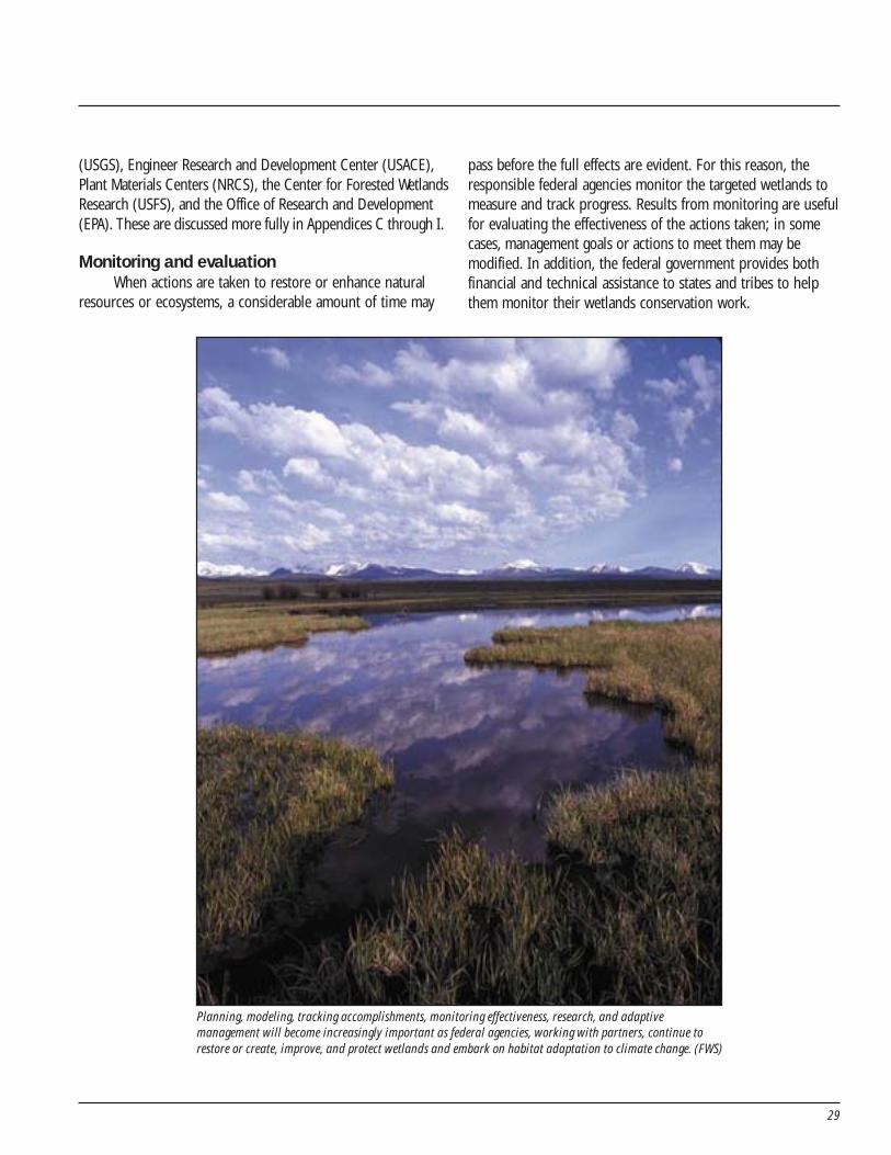
29
(USGS), Engineer Research and Development Center (USACE),Plant Materials Centers (NRCS), the Center for Forested WetlandsResearch (USFS), and the Office of Research and Development(EPA). These are discussed more fully in Appendices C through I.
Monitoring and evaluationWhen actions are taken to restore or enhance natural
resources or ecosystems, a considerable amount of time may
pass before the full effects are evident. For this reason, theresponsible federal agencies monitor the targeted wetlands tomeasure and track progress. Results from monitoring are usefulfor evaluating the effectiveness of the actions taken; in somecases, management goals or actions to meet them may bemodified. In addition, the federal government provides bothfinancial and technical assistance to states and tribes to helpthem monitor their wetlands conservation work.
Planning, modeling, tracking accomplishments, monitoring effectiveness, research, and adaptivemanagement will become increasingly important as federal agencies, working with partners, continue torestore or create, improve, and protect wetlands and embark on habitat adaptation to climate change. (FWS)

30
31
Appendix C.U.S. Department of Agriculture
Table C-1. USDA Programs Supporting the President’s WetlandsGoal in FY 2009. Funding (millions of dollars)
Agency Program
Restore
or
Create Improve Protect
Total
Wetlands
Funding
for goal
FY 2009
Difference
from
FY 2008
FSAConservation
Reserve Program13.900 5.200 0.000 19.100 3.100
NRCS
Conservation
Technical
Assistance
Program
10.870 16.083 0.000 26.953 0.000
NRCS
Environmental
Quality Incentives
Program
0.160 0.030 0.000 0.190 0.000
NRCS
Farm and
Ranchlands
Protection Program
0.000 0.000 7.000 7.000 0.000
NRCSGrasslands
Reserve Program0.000 0.000 0.000 0.000 -0.461
NRCSWetlands Reserve
Program45.905 3.707 131.388 181.000 -274.000
NRCSWildlife Habitat
Incentives Program0.700 0.140 0.000 0.840 0.000
71.535 25.160 138.388 235.083 -271.361Totals
32
Agency Program
Restore
or
Create Improve Protect
Total
Wetlands
FY 2009
Difference
from
FY 2008
FSAConservation
Reserve Program25,800 1,900 0 27,700 8,500
NRCS
Conservation
Technical
Assistance
Program
17,442 33,858 0 51,300 0
NRCS
Environmental
Quality Incentives
Program
500 250 0 750 0
NRCS
Farm and
Ranchlands
Protection Program
0 0 5,000 5,000 0
NRCSGrasslands
Reserve Program0 0 0 0 -760
NRCSWetlands Reserve
Program84,175 6,825 122,126 213,126 27,637
NRCSWildlife Habitat
Incentives Program8,050 352 0 8,402 0
135,967 43,185 127,126 306,278 35,377 Total
Table C-2. USDA Programs Supporting the President’s WetlandsGoal in FY 2009. Planned Accomplishments (in acres)
33
USDA Programs Supporting thePresident’s Wetlands Goal
Farm Service AgencyConservation Reserve Program (CRP): This program
establishes permanent vegetative cover on environmentallysensitive lands (including cropped and prior convertedwetlands) through long-term rental agreements. Currently, 2.4million wetland acres, including upland buffers, have beenrestored and are being maintained under 10- and 15-yearcontracts with annual rental payments of $126 million. The2002 Farm Bill authorized that, at any one time, up to 39.2million acres may be enrolled in CRP during 2002 through2007, an increase from 36.4 million acres authorized to beenrolled through 2002.http://www.fsa.usda.gov/FSA/webapp?area=home&subject=copr&topic=landing
Natural Resources Conservation ServiceConservation Technical Assistance (CTA) Program: In FY
2007, CTA helped landowners protect water quality on 6,374,280acres; improve fish and wildlife habitat quality on 2,781,782 acres;and create, restore, or enhance 58,595 acres of wetlands.http://www.nrcs.usda.gov/programs/cta
Environmental Quality Incentives Program (EQIP): Asa voluntary conservation program, EQIP promotes agriculturalproduction and environmental quality as compatible nationalgoals. Through EQIP, farmers and ranchers may receive financialand technical help to install and maintain conservation practicesthat enhance soil, water, and related natural resources, includingwetlands. The program has restored 33,808 acres of wetlands,and an additional 147,302 acres have been enhanced orimproved since the program was established in 1996. The 2002Farm Bill authorized $400 million for FY 2002, $700 million forFY 2003, $1 billion for FY 2004, $1.2 billion for both FY 2005and FY 2006, and $1.3 billion for FY 2007 and FY 2008.http://www.nrcs.usda.gov/programs/eqip
Farm and Ranchlands Protection Program: Thisprogram provides matching funds to help purchase develop-ment rights to keep productive farm and ranchland in agricul-tural uses for protecting topsoil by limiting conversion tononagricultural uses of land.http://www.nrcs.usda.gov/programs/frpp
Grasslands Reserve Program: This voluntary programoffers landowners the opportunity to protect, restore, and
enhance grasslands on their property. The program will conservevulnerable grasslands from conversion to cropland or other usesand conserve valuable grasslands by helping maintain viableranching operations. The program is jointly administered byNRCS and FSA (NRCS has lead responsibility on technical issuesand easement administration, and FSA has lead responsibility forrental agreement administration and financial activities). In FY2007, program staff processed 239 new applications totaling135,996 acres valued at approximately $12,893,272. Of thesetotals, farmers and ranchers preserved 13,000 acres of wetlandsusing common management practices to maintain the viability ofthe conserved grassland.http://www.nrcs.usda.gov/programs/grp
Wetlands Reserve Program ( WRP): WRP is a voluntaryprogram that assists landowners with restoring and protectingwetlands through conservation easements and cost-shareagreements. Since 1992, 1,921,144 wetland and associatedupland acres have been enrolled in the program. The 2002 FarmBill requires, to the maximum extent practicable, an additional250,000 acres to be enrolled in the program each year, for a totalprogram enrollment of 2,275,000 acres by the end of 2007. Totalprogram enrollment at the end of FY 2007 exceeded 1.92 millionwetland acres and associated upland acres.http://www.nrcs.usda.gov/programs/wrp
Wildlife Habitat Incentives Program ( WHIP): WHIP is avoluntary program that provides technical and financialassistance to enable eligible participants to develop uplandwildlife, wetland wildlife, threatened and endangered species,fish, and other types of wildlife habitat in an environmentallybeneficial and cost-effective manner. The purpose of theprogram is to create high-quality wildlife habitats that supportwildlife populations of local, state, and national significance. InFY 2006 through 2008, approximately 15,000 acres of wet-lands will have been protected, restored, developed, orenhanced under WHIP.http://www.nrcs.usda.gov/programs/whip/
USDA Programs that Maintain theWetlands Base
NRCS programs help private landowners apply neededconservation techniques on their land. When private landown-ers use these programs to restore, protect, and improvewetlands on their property, they serve as stewards of ourenvironment. Other cooperative conservation efforts include:

34
Plant Materials Program: This program focuses ondevelopment of plants and technology to help conserve naturalresources, including improving the function of wetlands. Thereare currently 27 plant materials centers (PMC) located acrossthe country. Each PMC develops vegetative solutions to naturalresource challenges within its service area. In the wetlandsarena, PMCs have selected over 56 improved plants forrestoration work, wetland enhancement, and nutrient filteringin constructed wetlands. Forty of these improved plants areuseful for revegetation within the Wetlands Reserve Program.The PMCs also develop the technology to successfully propa-gate, establish, and manage plant materials in wetland settings.
In FY 2008, PMCs are working on 50 studies directlyassociated with furthering the technology of vegetation inwetlands, as well as an additional 100 studies that will indirectlybenefit wetlands. These benefits include technology to protectand restore coastal marshes, improve the establishment ofsubmerged aquatic vegetation, restore or enhance wetlands,
protect the shorelines and buffer zones of wetlands, andenhance wetlands for wildlife uses and to support the WetlandsReserve Program. FY 2009 funding request is $10.9 million.
National Resources Inventory: NRCS conducts theNational Resources Inventory (NRI) in cooperation with IowaState University’s Center for Survey Statistics and Methodology.The NRI is a scientifically based longitudinal (statistical) surveyof the nation’s natural resources that provides information onstatus and trends of land use and soil, water, and relatedresources for the nation’s non-federal land. The NRI is uniquein that it provides nationally consistent statistical data that areexplicitly linked to the NRCS Soil Interpretations database andthat support analysis of resource trends on rural and devel-oped land over all regions of the United States since 1982. TheNRI shows that between 1997 and 2003 there was an estimatednet gain of 263,000 acres of wetlands due to agriculturalactivities—an average annual increase of 44,000 acres.http://www.nrcs.usda.gov/technical/nri
35
Appendix D.Department of Commerce
National Oceanic and Atmospheric Administration (NOAA)
Table D-1. NOAA Programs Supporting the President’s WetlandsGoal in FY 2009. Funding (millions of dollars)
NOAA Programs Supporting thePresident’s Wetlands Goal
Community-based Restoration Program (CRP): UnderFisheries and Habitat Restoration, the CRP applies a grassrootsapproach to restoration by actively engaging communitymembers in on-the-ground restoration of coastal fisheryhabitats around the nation. The CRP embraces cooperativeconservation, providing funding and technical expertise andestablishing partnerships that collaboratively restore NOAAtrust resources to improve environmental quality andstrengthen stewardship within local communities. FY 2009funding request is $13.1 million.http://www.nmfs.noaa.gov/habitat/restoration/projects_ programs/crp/
Great Lakes Habitat Restoration Program: In FY 2009,NOAA will establish a cross-NOAA program to coordinate
habitat restoration and protection efforts. Taking into accountthe priority needs identified by the Great Lakes InteragencyTask Force, NOAA will focus its restoration and protectionsupport on ongoing efforts at watersheds within Great LakesAreas of Concern. FY 2009 funding request is $1.5 million.http://www.corporateservices.noaa.gov/~nbo/08bluebook_highlights.html
NOAA Programs that Maintain theWetlands Base
National Estuarine Research Reserve System: Thisnetwork of protected areas was established for long-termresearch, education, and stewardship. The partnership pro-gram between NOAA and the coastal states protects more thanone million acres of estuarine land and water, which providesessential habitat for wildlife; offers educational opportunitiesfor students, teachers, and the public; and serves as living
Agency Program
Restore
or
Create Improve Protect
Total
Wetlands
Funding
for goal
FY 2009
Difference
from
FY 2008
NOAAFisheries Habitat
Restoration0.842 14.578 0.000 15.420 -0.655
Table D-2. NOAA Programs Supporting the President’s WetlandsGoal in FY 2009. Planned Accomplishments (in acres)
Agency Program
Restore
or
Create Improve Protect
Total
Wetlands
FY 2009
Difference
from
FY 2008
NOAAFisheries Habitat
Restoration7,000 2,000 0 9,000 1,000
36
laboratories for scientists. FY 2009 funding request foroperations and program support is $17.1 million. Additionally,$6.89 million is requested for land acquisition and constructionactivities (lands acquired with these funds will be incorporatedinto reserve boundaries), and $5.2 million is requested for acompetitive research program that will be administered by theNERRS program.http://nerrs.noaa.gov
Coastal Zone Management Program: The Coastal ZoneManagement (CZM) program is a voluntary federal–statepartnership dedicated to comprehensive management of thenation’s coastal resources. State CZM programs containprovisions for the protection of estuaries, coastal wetlands, andother natural resources. Funding supports implementation ofstate CZM programs, which include numerous state and localcoastal habitat protection and restoration projects. FY 2009funding request is $66.1 million.http://coastalmanagement.noaa.gov/
Coastal and Estuarine Land Conservation Program(CELCP): The CELCP was established to protect coastal andestuarine lands considered important for their ecological,conservation, recreational, historical, or aesthetic values, givingpriority to lands with significant ecological values that can beeffectively managed and protected. The program providesfunding to state and local governments to acquire such lands toensure they are permanently conserved for the benefit offuture generations. FY 2009 funding request is $15 million.http://coastalmanagement.noaa.gov/land
Pacific Coastal Salmon Recovery Fund (PCSRF):Congress established the PCSRF to contribute to the restorationand conservation of Pacific salmon and steelhead populationsand their habitats. The states of Washington, Oregon, Califor-nia, Idaho, and Alaska, and the Pacific Coastal and ColumbiaRiver tribes receive Congressional PCSRF appropriations fromNOAA’s National Marine Fisheries Service each year. The fundsupplements existing state, tribal, and local programs to fosterdevelopment of federal-state-tribal-local partnerships in salmonand steelhead recovery and conservation. The President’s FY2009 request for the fund is $35 million.http://nwr.nmfs.noaa.gov/salmon-recovery-planning/pcsrf/
National Estuaries Restoration Inventory: This programwas created to track estuary habitat restoration projects acrossthe nation. The purpose of the inventory is to provide informa-tion on restoration projects in order to improve restorationmethods, as well as to track acreage restored toward the million-acre goal of the Estuary Restoration Act.http://neri.noaa.gov
Damage Assessment, Remediation, and RestorationProgram (DARRP): As a natural resource trustee, NOAA acts onbehalf of the public to restore resources injured by oil spills,releases of other hazardous substances, and vessel groundings.DARRP collaborates with other federal, state, and tribal naturalresource trustees in assessing and quantifying injuries to naturalresources, seeking damages for those injuries, implementingrestoration actions, and monitoring progress to ensure restora-tion goals are met. FY 2009 funding request is $11.3 million.http://response.restoration.noaa.gov/http://www.darrp.noaa.gov/
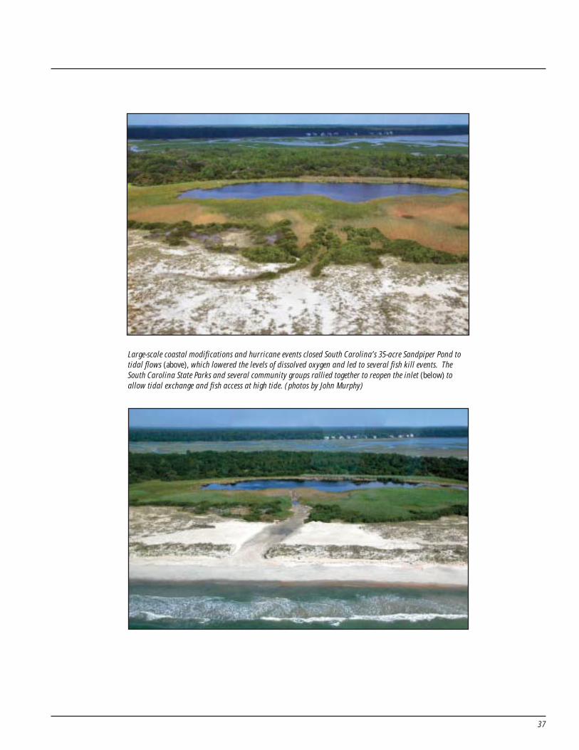
37
Large-scale coastal modifications and hurricane events closed South Carolina’s 35-acre Sandpiper Pond totidal flows (above), which lowered the levels of dissolved oxygen and led to several fish kill events. TheSouth Carolina State Parks and several community groups rallied together to reopen the inlet (below) toallow tidal exchange and fish access at high tide. (photos by John Murphy)

38
39
Appendix E.Department of the Army
U.S. Army Corps of Engineers, Civil WorksTable E-1. USACE Programs Supporting the President’sWetlands Goal in FY 2009. Funding (millions of dollars)
Agency Program
Restore
or
Create Improve Protect
Total
Wetlands
Funding
for goal
FY 2009
Difference
from FY
2008
USACEAquatic Ecosystem
Restoration Program39.200 203.000 0.800 243.000 0.000
Table E-2. USACE Programs Supporting the President’sWetlands Goal in FY 2009. Planned Accomplishments (in acres)
Agency Program
Restore
or
Create Improve Protect
Total
Wetlands
FY 2009
Difference
from FY
2008
USACEAquatic Ecosystem
Restoration Program1,642 15,741 0 17,383 -76
USACE Projects Supporting thePresident’s Wetlands Goal
Aquatic Ecosystem RestorationThe U.S. Army Corps of Engineers (USACE) has numerous
study, project-specific, and programmatic authorities forimplementing aquatic ecosystem restoration projects. The goalis to help restore aquatic habitat to a less degraded and morenatural condition in ecosystems whose structure, function, anddynamic processes have become degraded. In addition,activities contributing to the President’s goal may occur on the12 million acres of water and land managed by the USACE forother purposes, such as flood damage reduction, navigation,and recreation. Another contribution is the use of dredgedmaterial to create, restore, or improve wetland habitat as partof routine maintenance dredging of federal channels.
The data in the tables above represent a subset of thetotal USACE commitment to achieving the President’s goals.Because most USACE restoration projects take several years tocomplete, the funds appropriated in any one fiscal year have aminimal correlation to the number of acres that count towardthe President’s goal in that fiscal year. Projects are included inthe budget based on their effectiveness in addressing significantregional or national aquatic ecological problems. The aquaticecosystem studies and projects proposed by the USACE forfunding in FY 2009 include the following examples.
Comprehensive Everglades Restoration Plan (CERP):The primary and overarching purpose of CERP is to restore theSouth Florida ecosystem, which includes the Everglades. Theplan provides the framework and guidance to re-establish,rehabilitate, protect, and preserve the water resources of thegreater Everglades ecosystem. CERP has been described as theworld’s largest ecosystem restoration effort, and includes
40
providing more natural flows of water, improved water quality,and more natural hydro-periods within the remaining naturalareas. The plan is intended to help restore the ecosystem whileensuring clean and reliable water supplies, and providing floodprotection in urban areas.http://www.evergladesplan.org
Louisiana Coastal Area, La. Ecosystem Restoration:More than one million acres of Louisiana’s coastal wetlandshave been lost since the 1930s; another third of a million acrescould be lost over the next 50 years unless large-scale correc-tive actions are taken. The ecosystem restoration program willconstruct significant restoration features; undertake demon-stration projects; study potentially promising large-scale, long-term concepts; and take other needed actions to restore theecosystem. A 10-year plan of studies and projects was devel-oped through a public involvement process, and workingclosely with other federal agencies and the state of Louisiana.http://www.mvn.usace.army.mil/prj/lca/
Also in support of the projects is a science and technol-ogy program. This program provides the necessary science andtechnology to effectively address coastal ecosystem restorationneeds; provides analytical tools and recommendations to theprogram management team for appropriate studies to reduceuncertainties; integrates the roles and resources of the scien-tific community and other coastal protection agencies andpartners at the state, local, and federal level; and provides forinternal and external technical review and a systematic ap-proach for coordination with other ongoing and plannedrelated research activities.http://el.erdc.usace.army.mil/lcast/
Upper Mississippi River Environmental RestorationProgram: Originally authorized in 1986 but significantlymodified in 1999, the Environmental Restoration Program(ERP) provides for planning, construction, and evaluation ofmeasures for fish and wildlife habitat rehabilitation. Multiplehabitat projects are helping to revitalize the side channels andto re-establish or rehabilitate island, aquatic, and riparianhabitat in the Upper Mississippi River. The program alsoincludes funds for the collection of project and systemicbaseline data and monitoring.http://www.mvr.usace.army.mil/emp
Over the past 18 years, the ERP’s Habitat Rehabilitationand Enhancement Project (HREP) component has evolved intoa successful program that combines a broad range of construc-
tion techniques with approaches that strive to use or mimicnatural riverine processes, providing benefits to the river atsystem, reach, pool, and local scales. Since its 1999 reauthoriza-tion, the HREP program has continued to build upon thesuccessful foundation established in the program’s first years.
USACE Programs that Maintain the WetlandsBase
Environmental Stewardship: Together with its partners,the USACE provides environmental stewardship of nearly 12million acres of public land and water and oversees the naturalresources management of 456 operating civil works waterresources projects nationwide. The USACE strives to providesound environmental stewardship of lands and waters en-trusted to its care, while accomplishing multiple authorizedproject purposes. Its natural resources management mission isto manage and conserve those natural resources (including fishand wildlife, woodlands and grasslands, wetlands, soils, andwater) consistent with ecosystem sustainability principles, toserve the needs of present and future generations.
The stewardship of wetland resources is an integral partof the USACE stewardship responsibility. Although the classifi-cation and quantity of wetland acreage under USACE steward-ship has not yet been determined, an inventory of naturalresources (including wetlands) is required for each project.This effort is underway and is being accomplished as fiscalresources allow. Information from the inventories is incorpo-rated into master plans and operational management plans, andis used to help manage, conserve, and/or protect wetlandresources. Where feasible, wetland resources management isintegrated to provide mutual benefits, such as for efforts tomanage wetland-dependent plants and animals, includingendangered species. In addition, the effects of existing andproposed land-use activities are monitored or evaluated toguard against wetland degradation or loss. Opportunities toenhance wetland quality and quantity are implemented wherefeasible, employing partnerships and volunteer assistancewhere possible.http://corpslakes.usace.army.mil/employees/envsteward/envsteward.html
U.S. Army Engineer Research and DevelopmentCenter (ERDC): Within the Environmental Laboratory, theWetlands and Coastal Ecology group conducts field andlaboratory investigations on biotic and abiotic resources inwetlands and coastal systems and develops products/systems
41
supporting assessment, restoration, and management ofwetlands and coastal ecosystems. Examples of wetlandsresearch include the development of improved standards,techniques, and guidelines for the planning, design, andconstruction of USACE wetland restoration and creationprojects, as well as exploration of innovative plant harvesting/installation methods for the large-scale restoration of sub-merged aquatic vegetation ecosystems in the Chesapeake Bay.In addition, state-of-the-art tools and methods for wetlandsrestoration will be integrated to forecast physical, chemical,and biological responses to water resource managementactivities and to manage these resources within a watershed-scale perspective. Approximately $2.2 million is included in theFY 2009 budget for wetlands research.http://el.erdc.usace.army.mil/org.cfm?Code=EE-W
Regulatory Clean Water Act 404 Program: The USACEmanages the nation’s wetlands through a regulatory programrequiring permits for the discharge of dredged and fill materialinto jurisdictional waters of the United States. In a typical yearthe USACE receives permit requests to fill about 25,000 acresof jurisdictional waters. Of these, about 5,000 acres are notpermitted and, with respect to the 20,000 acres that arepermitted, the USACE requires mitigation on average of morethan two acres for each permitted acre lost. This importantregulatory program helps maintain the wetland base so otherfederal programs can achieve gains. FY 2009 funding request is$180 million.http://www.usace.army.mil/inet/functions/cw/cecwo/reg

42
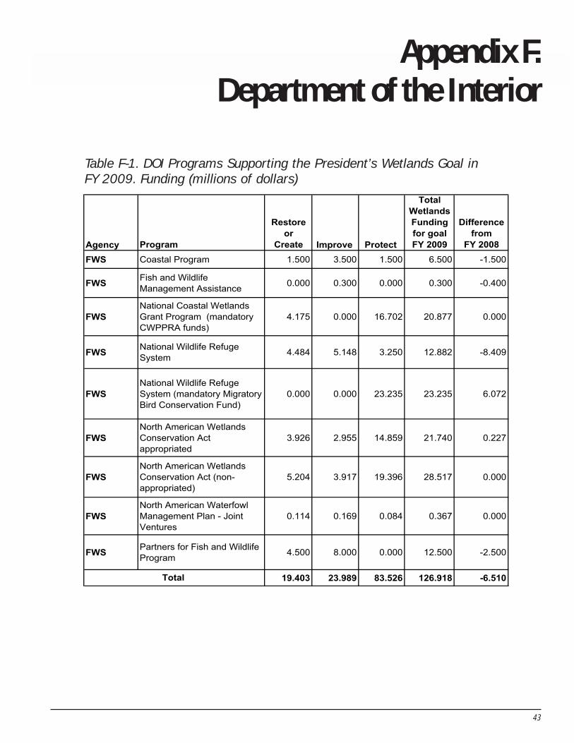
43
Appendix F.Department of the Interior
Table F-1. DOI Programs Supporting the President’s Wetlands Goal inFY 2009. Funding (millions of dollars)
Agency Program
Restore
or
Create Improve Protect
Total
Wetlands
Funding
for goal
FY 2009
Difference
from
FY 2008
FWS Coastal Program 1.500 3.500 1.500 6.500 -1.500
FWSFish and Wildlife
Management Assistance 0.000 0.300 0.000 0.300 -0.400
FWS
National Coastal Wetlands
Grant Program (mandatory
CWPPRA funds)
4.175 0.000 16.702 20.877 0.000
FWSNational Wildlife Refuge
System 4.484 5.148 3.250 12.882 -8.409
FWS
National Wildlife Refuge
System (mandatory Migratory
Bird Conservation Fund)
0.000 0.000 23.235 23.235 6.072
FWS
North American Wetlands
Conservation Act
appropriated
3.926 2.955 14.859 21.740 0.227
FWS
North American Wetlands
Conservation Act (non-
appropriated)
5.204 3.917 19.396 28.517 0.000
FWS
North American Waterfowl
Management Plan - Joint
Ventures
0.114 0.169 0.084 0.367 0.000
FWSPartners for Fish and Wildlife
Program4.500 8.000 0.000 12.500 -2.500
19.403 23.989 83.526 126.918 -6.510Total
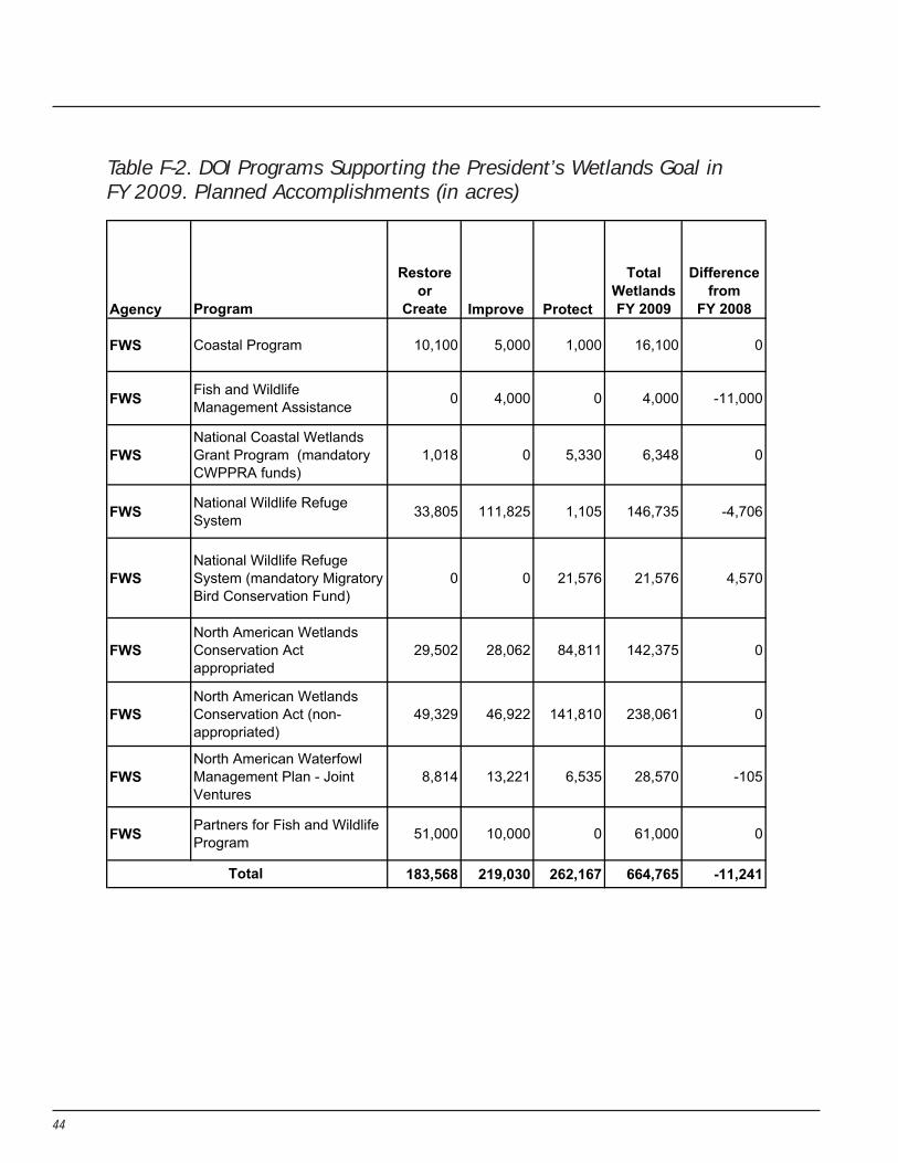
44
Table F-2. DOI Programs Supporting the President’s Wetlands Goal inFY 2009. Planned Accomplishments (in acres)
Agency Program
Restore
or
Create Improve Protect
Total
Wetlands
FY 2009
Difference
from
FY 2008
FWS Coastal Program 10,100 5,000 1,000 16,100 0
FWSFish and Wildlife
Management Assistance 0 4,000 0 4,000 -11,000
FWS
National Coastal Wetlands
Grant Program (mandatory
CWPPRA funds)
1,018 0 5,330 6,348 0
FWSNational Wildlife Refuge
System 33,805 111,825 1,105 146,735 -4,706
FWS
National Wildlife Refuge
System (mandatory Migratory
Bird Conservation Fund)
0 0 21,576 21,576 4,570
FWS
North American Wetlands
Conservation Act
appropriated
29,502 28,062 84,811 142,375 0
FWS
North American Wetlands
Conservation Act (non-
appropriated)
49,329 46,922 141,810 238,061 0
FWS
North American Waterfowl
Management Plan - Joint
Ventures
8,814 13,221 6,535 28,570 -105
FWSPartners for Fish and Wildlife
Program51,000 10,000 0 61,000 0
183,568 219,030 262,167 664,765 -11,241Total
45
DOI Programs Supporting the President’sWetlands Goal
Fish and Wildlife Service (FWS)Coastal Program: The Coastal Program works in 22
specific coastal communities to improve the health of water-sheds for fish, wildlife, and people by building partnerships;identifying, evaluating, and mapping important habitats;restoring habitats; and providing technical assistance andfinancial support to help protect important coastal habitats.Since 1994, the program has re-established or rehabilitated115,000 acres of coastal wetlands, 28,000 acres of coastaluplands, and more than 1,150 miles of coastal streamsidehabitat. It has also helped protect 1.35 million acres of coastalhabitat. FWS also provides technical assistance to other federal,state, and local agencies under this program.http://www.fws.gov/coastal
Fish and Wildlife Management Assistance (FWMA):This program delivers scientific information and projects thatsupport cooperative efforts to conserve America’s fisheries andwildlife resources. FWMA includes on-the-ground conservationactivities, such as assessing the condition of habitats, restoringstream and wetland habitats, restoring fish passage, andcontrolling aquatic nuisance species through physical, chemi-cal, and biological means.http://www.fws.gov/fisheries/fwma/
National Coastal Wetlands Conservation GrantsProgram: Since 1990, the program has made available morethan $202 million to 25 coastal states and one U.S. territory toacquire, conserve, or restore over 244,000 acres of coastalwetland ecosystems. Typically, between $17 and $20 million isawarded annually through a national competitive process.Grants for an individual project are limited to $1 million.Funding for this program comes from excise taxes on fishingequipment and motorboat and small engine fuels. States arerequired to provide either 50 or 75 percent of the total cost ofthe project, depending on whether the state has establishedand maintains a special fund for acquiring coastal wetlands,other natural areas, and open space. The program does notprovide grants to support planning, research, monitoringactivities, or construction or repair of structures for recre-ational purposes.http://www.fws.gov/coastal/coastalgrants
National Wildlife Refuge System: The mission of theNational Wildlife Refuge System, managed by FWS, is toadminister a national network of lands and waters for theconservation, management, and, where appropriate, restora-tion of the fish, wildlife, and plant resources and their habitatswithin the United States for the benefit of present and futuregenerations of Americans. Approximately one-quarter of the 96-million-acre National Wildlife Refuge System consists ofwetlands. The Refuge System protects, restores, rehabilitates,enhances, and conducts research on these wetlands. TheRefuge System sustains wetlands to enhance their value formigratory waterfowl and shorebirds, threatened and endan-gered species, and a myriad of native fish, wildlife, and plants.The wetland restoration and conservation programs of theRefuge System sustain the biodiversity and environmentalhealth of these habitats across diverse landscapes, and providewildlife-dependent recreational opportunities for the Americanpublic.http://www.fws.gov/refuges/
National Wildlife Refuge System, Migratory BirdConservation Fund program: The Migratory Bird Conserva-tion Fund program finances two land acquisition programs thatprotect wetlands. Financed by the sale of Federal MigratoryBird Hunting and Conservation Stamps (commonly known asFederal Duck Stamps), import duties, and refuge rights-of-wayfees, the Fund purchases major areas for migratory birds underthe authority of the Migratory Bird Conservation Act, and small,natural wetlands and interests under authority of the MigratoryBird Hunting and Conservation Stamp Act.
North American Wetlands Conservation Act Program:This program supports voluntary public–private partnershipsto conserve North American wetland ecosystems. It providesmatching grants to public and private groups and agencies forwetlands restoration and protection in the United States,Canada, and Mexico. More than 14.7 million acres of wetlandsand associated uplands have been protected, restored, orenhanced by program activities since 1991.http://birdhabitat.fws.gov/nawca/grants.htm
North American Waterfowl Management Plan–JointVentures: This tri-national strategic plan fosters the creation ofpartnerships among the federal government, states, tribes,corporations, private organizations, and individuals to cooper-ate in the planning, funding, and implementation of projects toconserve and enhance wetland habitat in high-priority “jointventure” regions. The plan calls for 16.1 million acres of
46
wetlands and associated uplands to be protected and 12.1million acres to be restored or enhanced.http://www.fws.gov/birdhabitat/nawmp
Partners for Fish and Wildlife Program: Authorized bythe Partners for Fish and Wildlife Act, this voluntary program,begun in 1987, works with landowners to restore fish andwildlife habitat including wetlands on private lands usingcooperative agreements. The FWS has entered into more than41,000 agreements with partners. The program has restored800,000 acres of wetlands and rehabilitated more than 1.6million acres of uplands and more than 6,000 miles of riparianand in-stream habitat. FWS also provides technical assistance toother federal, state, and local agencies under this program.http://www.fws.gov/partners
DOI Programs that Maintain the WetlandsBase
Fish and Wildlife ServiceNational Wildlife Refuge System: In FY 2007, the
National Wildlife Refuge System managed 135,174 acres formoist soils and 848,302 acres received other water-levelmanipulation. In FY 2008, those management activity accom-plishments are expected to include 127,274 moist soil acresmanaged, with water-level manipulation achieved on 841,459acres of water impoundments.http://www.fws.gov/refuges/
National Wetlands Inventory (NWI): The goal of the NWIis to produce information on the characteristics, extent, andstatus of the nation’s wetlands and deepwater and riparianhabitats in order to promote the understanding and conservationof these resources. The program currently has data for 56percent of the nation available on-demand and is updating onepercent per year. Federal, state, and local government agencies;tribes; academic institutions; Congress; and the private sectoruse this information and digital maps to guide natural resourceplanning, management, and project development. Wetlands dataare used in planning for emerging conservation issues such asenergy development, species population declines, avian influenza,and global climate change (where they are used to model sea-level rise). The wetlands data are available over the Internet.Wetlands status and trend data and reports provide contempo-rary information for decision-making and for wetlands policyformulation, assessment, and performance monitoring.http://www.fws.gov/nwi
Natural Resource Damage Assessment and Restoration(NRDAR) Program: The FWS’s NRDAR Program, as part of theEnvironmental Contaminants Program, restores wetland acresthat have been harmed by the release of contaminants fromformer hazardous waste sites and oil and chemical spills. In FY2007, the NRDAR program was responsible for the restorationand enhancement of nearly 5,000 wetland acres and for theprotection of 2,400 wetland acres. In addition, the Programrestored or enhanced 171 riparian stream miles and managedor protected 157 riparian stream miles. Where possible, theFWS partners with other federal agencies, other FWS programs,states, tribes, or non-governmental organizations to enlargethese ongoing restoration efforts, which increases the value ofthe restoration to fish and wildlife. Such efforts are critical tomaintaining high-quality base wetland acres. The Division ofEnvironmental Quality provides approximately $1.5 million intoxicology, ecology, and habitat restoration expertise to EPAand other federal and state partners to minimize impacts towetlands during the cleanup of contaminated areas. Thedivision makes substantial contributions to maintaining thebase of wetland acres as well as restoring and improvingwetlands at former hazardous waste sites and areas impactedby oil and chemical spills.http://contaminants.fws.gov/issues/restoration.cfm
U.S. Geological Survey (USGS)Healthy wetland ecosystems provide habitat for diverse
fish and wildlife communities, protection from erosion andflood attenuation from extreme storm events, water quality,and recreational opportunities. Studies conducted by USGSscientists describe factors that control wetland ecosystemstructure, dynamics, function, interactions with the surround-ing landscapes, and the provision of goods and services. Thisinformation is used to predict future changes to ecosystemsand describe the results of management alternatives. In supportof federal and state resource managers, USGS providesscientific expertise that helps decision makers build andimplement adaptive management strategies to support wetlandsrestoration and creation and to effectively improve and protectcoastal, forested, and freshwater wetlands and identify mea-sures to adapt management to climate change.http://biolog y.usgs.gov/ecosystems/wetlands.html
Areas of wetlands research by USGS include:
Prairie Pothole Region/Great Plains: Research in thisregion expands the ecological understanding of processes thatinfluence wetland functions and values in agriculture land-
47
scapes. Research on global climate change, sediment andnutrient dynamics, the effectiveness of wetland restoration andenhancement for flood storage and wildlife habitat, and thepotential of prairie pothole wetlands to sequester carbon arealso being addressed.http://www.npwrc.usgs.gov/about/factsheet/wetlands.htm
Great Lakes: In this region, the effects of Great Lakeswater-level fluctuations on wetlands are being researched, inaddition to global climate change studies that focus on interac-tions between climate change, lake levels, groundwaterhydrology, and wetland response. This research providesscientific information to support the restoration, conservation,and management of wetlands and fisheries habitats.http://www.glsc.usgs.gov
Gulf Coast: Hurricanes Katrina and Rita placed a highpriority on research, spatial analyses, predictive modeling,technology development, and information synthesis andoutreach related to the impacts to the nation’s critical Gulf Coastcoastal and freshwater wetlands and habitats. USGS wetlandsscience in this region provides scientific information thatresource managers and planners need to stabilize, restore,rehabilitate, and manage wetlands, including seagrass beds,mangrove forests, coastal saltwater and freshwater marshes, andforested wetlands. In addition, global climate change studiesfocus on riverine and coastal wetland response to CO2 levels inthe Lower Mississippi River Valley and the response of coastalwetlands to sea level rise and extreme events along the coast.http://www.nwrc.usgs.gov
Atlantic Coast: Wetlands research in the Atlantic regionprovides scientific information on restoration, enhancement,and creation of coastal and estuarine wetlands; wetlandshealth; and sustainability for the goods and services theyprovide. A major focus in this area includes global climatechange studies, which focus on wetland response to sea levelrise and wetland management options in maintaining healthywetlands and critical habitat for migrating waterfowl andfisheries species. Other investigations include the effects ofvarying fire regimes on wetland habitats in maintaining eleva-tion in response to sea level rise.http://www.pwrc.usgs.gov/wetlands
Puget Sound: Wetlands research in the Puget Soundfocuses on understanding nearshore ecosystem processes andlinkages to watersheds and wetlands, decision support andadaptive management strategies for coastal marsh and associ-ated near-shore habitat restoration for benthic and aquatic
organisms such as fisheries, and integrated research to improverestoration techniques for vegetated estuarine and coastalwetlands. The role of wetlands in urban and rural settings andthe relationship to fisheries will also be investigated.http://puget.usgs.gov/
Montane Wetlands: Wetlands and related riparianresearch in the montane regions of the West focuses on therelationship of sedimentation and vegetation dynamics inagricultural landscapes, the effectiveness of restoration effortsin meeting the habitat needs of wildlife and migratory birds,cumulative effects of groundwater withdrawal on wetlandprocesses, water level management on wildlife areas in relationto wetland dynamics and climate patterns, and wetland andriparian restoration for management in a changing climate.http://www.nrmsc.usgs.gov/research/montane_wetlands.htm
Restoring the Nation’s Greater Everglades and CoastalEcosystems: Restoring the nation’s Greater Everglades andadjacent Florida Bay and Biscayne Bay coastal ecosystems insouth Florida, over half of which is under the stewardship ofthe Department of the Interior, is the largest environmentalrestoration project ever attempted in the United States. USGScontinues to be a key partner in Greater Everglades restorationby providing fundamental and applied scientific information onecosystem history, water quality and contaminants, surface andgroundwater flows, and species responses to hydropatterndynamics. A major USGS thrust continues to be the develop-ment of new and improved ecosystem models such as hydro-logic, ecological, landscape, and water quality/ contaminantmodels. These models are being integrated into decisionsupport tools to aid in restoration-related planning decisions bythe Fish and Wildlife Service, National Park Service, U.S. ArmyCorps of Engineers, Florida Department of EnvironmentalProtection, EPA, and the South Florida Water ManagementDistrict to predict the consequences of varied managementalternatives, set ecological goals by providing yardsticks tomeasure restoration success, and manage the natural resourcesof the system.http://sofia.usgs.gov/
California Bay-Delta: Activities in the San Francisco bayand delta focus on providing status and trend information onwater quality in the San Joaquin River, Sacramento Riverwatersheds, and San Francisco estuary; wetlands restoration;and unbiased and reliable scientific information and tools thatexplain the occurrence and effects of toxic substances in theBay-Delta hydrologic environment. These activities support or
48
have related and overlapping objectives with the state/federalagencies’ CALFED Bay-Delta Program and the South Bay SaltPond Restoration Project. CALFED is a multi-agency, multi-billion-dollar, 30-year plan to restore ecosystem functions,improve water supply reliability, provide wetland restorationfor water quality improvement and wildlife habitat, and sustainwater quality for California watersheds. USGS providesleadership for CALFED’s scientific aspects and specific studiesthat develop new knowledge meant to improve programdecisions and be relevant to CALFED proposed actions. In FY
2008 and FY 2009, USGS will continue to work on identifyingthe effects of the changing hydrology, infrastructure, andclimate on the physical, chemical, and biological processes ofthe system. USGS will also address the interaction betweenimportant processes of the marshes and adjacent bays, with afocus on current declines of pelagic fish species and therestoration of salt ponds in ecosystems compatible with theneeds of the San Francisco bay and freshwater delta.http://sfbay.wr.usgs.gov/
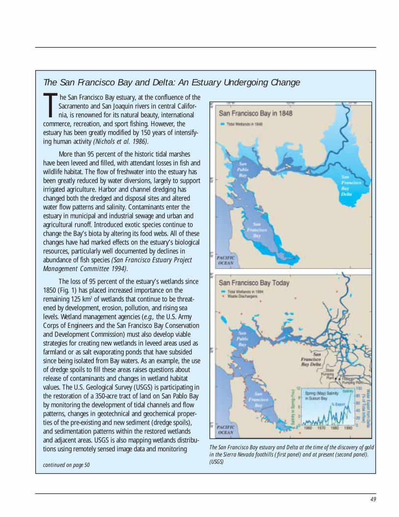
49
The San Francisco Bay and Delta: An Estuary Undergoing Change
The San Francisco Bay estuary, at the confluence of theSacramento and San Joaquin rivers in central Califor-nia, is renowned for its natural beauty, international
commerce, recreation, and sport fishing. However, theestuary has been greatly modified by 150 years of intensify-ing human activity (Nichols et al. 1986).
More than 95 percent of the historic tidal marsheshave been leveed and filled, with attendant losses in fish andwildlife habitat. The flow of freshwater into the estuary hasbeen greatly reduced by water diversions, largely to supportirrigated agriculture. Harbor and channel dredging haschanged both the dredged and disposal sites and alteredwater flow patterns and salinity. Contaminants enter theestuary in municipal and industrial sewage and urban andagricultural runoff. Introduced exotic species continue tochange the Bay’s biota by altering its food webs. All of thesechanges have had marked effects on the estuary’s biologicalresources, particularly well documented by declines inabundance of fish species (San Francisco Estuary ProjectManagement Committee 1994).
The loss of 95 percent of the estuary’s wetlands since1850 (Fig. 1) has placed increased importance on theremaining 125 km2 of wetlands that continue to be threat-ened by development, erosion, pollution, and rising sealevels. Wetland management agencies (e.g., the U.S. ArmyCorps of Engineers and the San Francisco Bay Conservationand Development Commission) must also develop viablestrategies for creating new wetlands in leveed areas used asfarmland or as salt evaporating ponds that have subsidedsince being isolated from Bay waters. As an example, the useof dredge spoils to fill these areas raises questions aboutrelease of contaminants and changes in wetland habitatvalues. The U.S. Geological Survey (USGS) is participating inthe restoration of a 350-acre tract of land on San Pablo Bayby monitoring the development of tidal channels and flowpatterns, changes in geotechnical and geochemical proper-ties of the pre-existing and new sediment (dredge spoils),and sedimentation patterns within the restored wetlandsand adjacent areas. USGS is also mapping wetlands distribu-tions using remotely sensed image data and monitoring The San Francisco Bay estuary and Delta at the time of the discovery of gold
in the Sierra Nevada foothills ( first panel) and at present (second panel).(USGS)continued on page 50
50
physical processes including currents, wind, and wavesthat alter wetlands and adjacent shallows. USGS isquantifying the distribution and elevations of theshoreline and developing models that characterize thephysical forces acting upon wetlands.
Recognition of the conflicts among the many usesof the Bay/Delta system have brought the public, re-source managers and regulators, and elected officialstogether to recognize the great need for credible,unbiased scientific information on the significance ofriver flow diversion, contaminant inputs, dredging, andhabitat alteration (San Francisco Estuary Project Manage-ment Committee 1994).
USGS, as a long-time leader in studies of the SanFrancisco Bay estuary, has provided much of the funda-mental knowledge of interrelations among the hydrology,geology, chemistry, and ecology of this complex estuarinesystem. The USGS is now focusing field, laboratory, andmodeling studies on the effects of freshwater flow on theestuary’s chemistry and biology, the distribution andinfluence of contaminants on estuarine invertebrates,and the processes influencing the character and stabilityof remaining wetlands.
References:Nichols, F. H., Cloern, J. E., Luoma, S. N., and Peterson, D.
H. 1986. The modification of an estuary. Science231:567–573.
San Francisco Estuary Project Management Committee.1994. Comprehensive Conservation and ManagementPlan: San Francisco Estuary Project.
http://biolog y.usgs.gov/ecosystems/interdecosci.html
The San Francisco Bay and Delta:An Estuary Undergoing Changecontinued from page 49
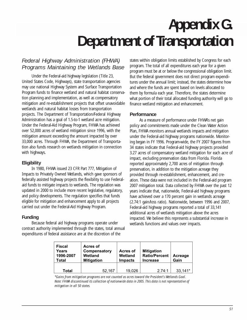
51
Appendix G.Department of Transportation
Federal Highway Administration (FHWA)Programs Maintaining the Wetlands Base
Under the Federal-aid highway legislation (Title 23,United States Code, Highways), state transportation agenciesmay use national Highway System and Surface TransportationProgram funds to finance wetland and natural habitat conserva-tion planning and implementation, as well as compensatorymitigation and re-establishment projects that offset unavoidablewetlands and natural habitat losses from transportationprojects. The Department of Transportation/Federal HighwayAdministration has a goal of 1.5-to-1 wetland acre mitigation.Under the Federal-Aid Highway Program, FHWA has achievedover 52,000 acres of wetland mitigation since 1996, with themitigation amount exceeding the amount impacted by over33,000 acres. Through FHWA, the Department of Transporta-tion also funds research on wetlands mitigation in connectionwith highways.
EligibilityIn 1980, FHWA issued 23 CFR Part 777, Mitigation of
Impacts to Privately Owned Wetlands, which gave sponsors offederally assisted highway projects the flexibility to use Federal-aid funds to mitigate impacts to wetlands. The regulation wasupdated in 2000 to include more recent legislative, regulatory,and policy developments. The regulation specifies that fundseligible for mitigation and enhancement apply to all projectscarried out under the Federal-Aid Highway Program.
FundingBecause federal aid highway programs operate under
contract authority implemented through the states, total annualexpenditures of federal assistance are at the discretion of the
states within obligation limits established by Congress for eachprogram. The total of all expenditures each year for a givenprogram must be at or below the congressional obligation limit.But the federal government does not direct program expendi-tures under the annual limit; instead, the states determine howand where the funds are spent based on levels allocated tothem by formula each year. Therefore, the states determinewhat portion of their total allocated funding authority will go tofinance wetland mitigation and enhancement.
PerformanceAs a measure of performance under FHWA’s net gain
policy and commitments made under the Clean Water ActionPlan, FHWA monitors annual wetlands impacts and mitigationunder the Federal-aid highway programs nationwide. Monitor-ing began in FY 1996. Program-wide, the FY 2007 figures from34 states indicate that Federal-aid highway projects provided3.27 acres of compensatory wetland mitigation for each acre ofimpact, excluding preservation data from Florida. Floridareported approximately 2,700 acres of mitigation throughpreservation, in addition to the mitigation acreage theyprovided through re-establishment, enhancement, and cre-ation. These data were not included in the Federal-aid program2007 mitigation total. Data collected by FHWA over the past 12years indicate that, nationwide, Federal-aid highway programshave achieved over a 170 percent gain in wetlands acreage(2.74:1 gain/loss ratio). Nationwide, between 1996 and 2007,Federal-aid highway programs reported a total of 33,141additional acres of wetlands mitigation above the acresimpacted. We believe this represents a substantial increase inwetlands functions and values over impacts.
Fiscal Years 1996-2007 Total
Acres of Compensatory Wetland Mitigation
Acres of Wetland Impacts
Mitigation Ratio/Percent Increase
Acreage Gain
Total 52,167 19,026 2.74:1 33,141* *Gains from mitigation programs are not counted as acres toward the President’s Wetlands Goal.
Note: FHWA discontinued its collection of nationwide data in 2005. This data is not representative ofmitigation in all 50 states.
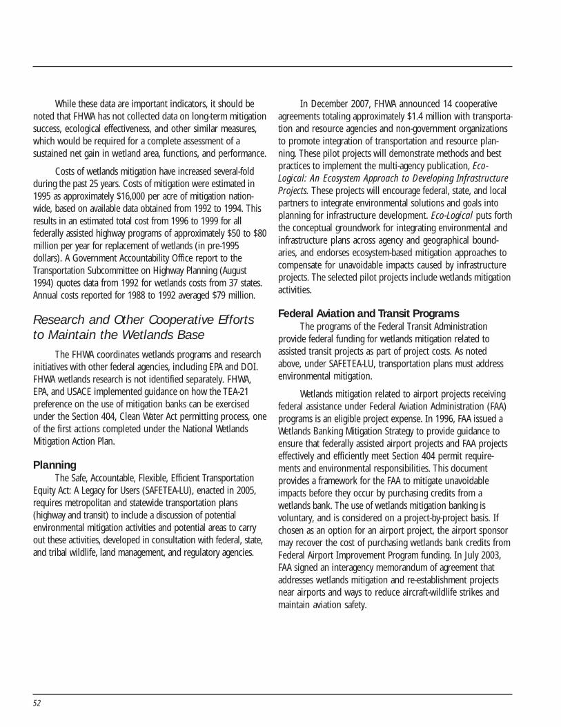
52
While these data are important indicators, it should benoted that FHWA has not collected data on long-term mitigationsuccess, ecological effectiveness, and other similar measures,which would be required for a complete assessment of asustained net gain in wetland area, functions, and performance.
Costs of wetlands mitigation have increased several-foldduring the past 25 years. Costs of mitigation were estimated in1995 as approximately $16,000 per acre of mitigation nation-wide, based on available data obtained from 1992 to 1994. Thisresults in an estimated total cost from 1996 to 1999 for allfederally assisted highway programs of approximately $50 to $80million per year for replacement of wetlands (in pre-1995dollars). A Government Accountability Office report to theTransportation Subcommittee on Highway Planning (August1994) quotes data from 1992 for wetlands costs from 37 states.Annual costs reported for 1988 to 1992 averaged $79 million.
Research and Other Cooperative Effortsto Maintain the Wetlands Base
The FHWA coordinates wetlands programs and researchinitiatives with other federal agencies, including EPA and DOI.FHWA wetlands research is not identified separately. FHWA,EPA, and USACE implemented guidance on how the TEA-21preference on the use of mitigation banks can be exercisedunder the Section 404, Clean Water Act permitting process, oneof the first actions completed under the National WetlandsMitigation Action Plan.
PlanningThe Safe, Accountable, Flexible, Efficient Transportation
Equity Act: A Legacy for Users (SAFETEA-LU), enacted in 2005,requires metropolitan and statewide transportation plans(highway and transit) to include a discussion of potentialenvironmental mitigation activities and potential areas to carryout these activities, developed in consultation with federal, state,and tribal wildlife, land management, and regulatory agencies.
In December 2007, FHWA announced 14 cooperativeagreements totaling approximately $1.4 million with transporta-tion and resource agencies and non-government organizationsto promote integration of transportation and resource plan-ning. These pilot projects will demonstrate methods and bestpractices to implement the multi-agency publication, Eco-Logical: An Ecosystem Approach to Developing InfrastructureProjects. These projects will encourage federal, state, and localpartners to integrate environmental solutions and goals intoplanning for infrastructure development. Eco-Logical puts forththe conceptual groundwork for integrating environmental andinfrastructure plans across agency and geographical bound-aries, and endorses ecosystem-based mitigation approaches tocompensate for unavoidable impacts caused by infrastructureprojects. The selected pilot projects include wetlands mitigationactivities.
Federal Aviation and Transit ProgramsThe programs of the Federal Transit Administration
provide federal funding for wetlands mitigation related toassisted transit projects as part of project costs. As notedabove, under SAFETEA-LU, transportation plans must addressenvironmental mitigation.
Wetlands mitigation related to airport projects receivingfederal assistance under Federal Aviation Administration (FAA)programs is an eligible project expense. In 1996, FAA issued aWetlands Banking Mitigation Strategy to provide guidance toensure that federally assisted airport projects and FAA projectseffectively and efficiently meet Section 404 permit require-ments and environmental responsibilities. This documentprovides a framework for the FAA to mitigate unavoidableimpacts before they occur by purchasing credits from awetlands bank. The use of wetlands mitigation banking isvoluntary, and is considered on a project-by-project basis. Ifchosen as an option for an airport project, the airport sponsormay recover the cost of purchasing wetlands bank credits fromFederal Airport Improvement Program funding. In July 2003,FAA signed an interagency memorandum of agreement thataddresses wetlands mitigation and re-establishment projectsnear airports and ways to reduce aircraft-wildlife strikes andmaintain aviation safety.
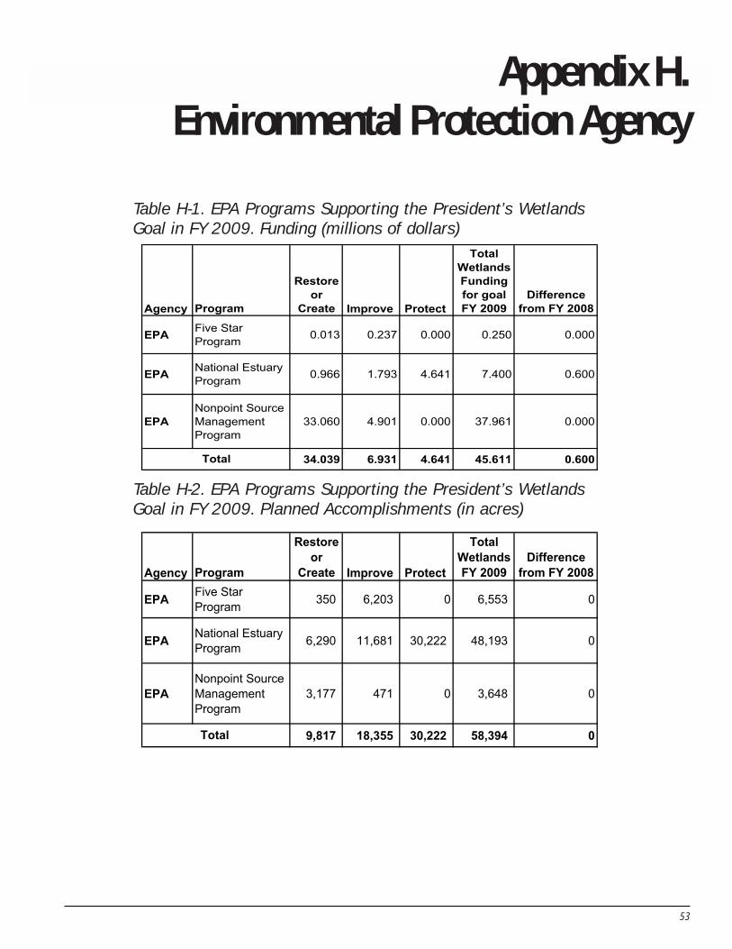
53
Appendix H.Environmental Protection Agency
Agency Program
Restore
or
Create Improve Protect
Total
Wetlands
Funding
for goal
FY 2009
Difference
from FY 2008
EPA Five Star
Program 0.013 0.237 0.000 0.250 0.000
EPA National Estuary
Program 0.966 1.793 4.641 7.400 0.600
EPA
Nonpoint Source
Management
Program
33.060 4.901 0.000 37.961 0.000
34.039 6.931 4.641 45.611 0.600Total
Agency Program
Restore
or
Create Improve Protect
Total
Wetlands
FY 2009
Difference
from FY 2008
EPA Five Star
Program 350 6,203 0 6,553 0
EPA National Estuary
Program 6,290 11,681 30,222 48,193 0
EPA
Nonpoint Source
Management
Program
3,177 471 0 3,648 0
9,817 18,355 30,222 58,394 0Total
Table H-1. EPA Programs Supporting the President’s WetlandsGoal in FY 2009. Funding (millions of dollars)
Table H-2. EPA Programs Supporting the President’s WetlandsGoal in FY 2009. Planned Accomplishments (in acres)
54
EPA Programs Supporting the President’sWetlands Goal
Five Star Challenge Grants Program: EPA and itspartners—National Fish and Wildlife Federation, NationalAssociation of Counties, Southern Company, Wildlife HabitatCouncil, and Pacific Gas & Electric—have helped catalyze over475 projects in all 50 states, the District of Columbia, and theU.S. Virgin Islands. Each year, 40 to 50 grants of $5,000 to$20,000 are awarded. The purpose of the Five Star RestorationProgram is to support community-based efforts to restorewetlands, river streams/corridors, and coastal habitat; builddiverse partnerships within the community; and foster localstewardship of resources through outreach.http://www.epa.gov/owow/wetlands/restore/5star
National Estuary Program (NEP): This program worksto restore and protect these sensitive and vital ecosystems. TheNEP provides funding and technical assistance to citizens,governments, businesses, researchers, and organizations inlocal communities to create and implement plans they developcollectively. These plans address problems facing their estuar-ies, such as excess nutrients, pathogens, toxic chemicals,introduced species, overfishing, and habitat loss and degrada-tion. With its partners, the NEP works to safeguard the health ofsome of our nation’s most productive natural resources, andtransfers the lessons learned to other watersheds.http://www.epa.gov/owow/estuaries
Nonpoint Source Management Plan: Under Section319 of the Clean Water Act, states, territories, and Indian tribesreceive grant money that supports a wide variety of activities,including technical assistance, financial assistance, education,training, technology transfer, demonstration projects, andmonitoring to assess the success of specific nonpoint-sourceimplementation projects, some of which include wetlandsrestoration projects.http://www.epa.gov/owow/nps/cwact.html
EPA Programs That Maintain theWetlands Base
Wetlands Grants Program: The EPA annually hasprovided funding to states, local governments, tribes, andnongovernmental organizations to strengthen and buildcomprehensive non-federal regulatory and nonregulatorywetlands programs. FY 2009 funding request is $16.8 million.http://www.epa.gov/owow/wetlands
Clean Water Act Section 404 Program: EPA and USACEshare regulatory responsibility pursuant to Clean Water ActSection 404. EPA and USACE establish the regulations andpolicies for implementation of the program, including develop-ment and implementation of the Section 404(b)(1) guidelines.The guidelines establish the substantive environmental criteriaused to evaluate applications for permits to discharge underSection 404. FY 2009 funding request is $22.2 million.http://www.epa.gov/owow/wetlands/
Ecological Research Program: EPA’s Office of Researchand Development conducts research on survey design,monitoring methods, and analyses used in the assessment ofthe quality of the nation’s waters, including wetlands. Researchis conducted in partnership with states and tribes to demon-strate how assessments of wetland condition can be used tomore effectively protect wetland resources and evaluate theeffectiveness of management actions including restoration. EPAawarded $1.1 million in 2007 to develop and test methods forassessing wetland condition in the Mid-Atlantic and Southeast.Approximately $400,000 has been set aside in FY 2008 dollarsto fund wetland projects in states in the Upper Midwest andRocky Mountain regions. In addition, technical assistance isbeing provided in support of the 2011 National WetlandCondition Assessment, including the funding of a pilot assess-ment of coastal wetlands in the Gulf of Mexico region. Othertechnical assistance, including training and data analysissupport, is being provided to states and tribes to aid in thedevelopment of wetland monitoring and assessment programs.The overall research program is increasing its focus on evaluat-ing ecosystem services provided by wetlands at multiple scales.http://www.epa.gov/ord
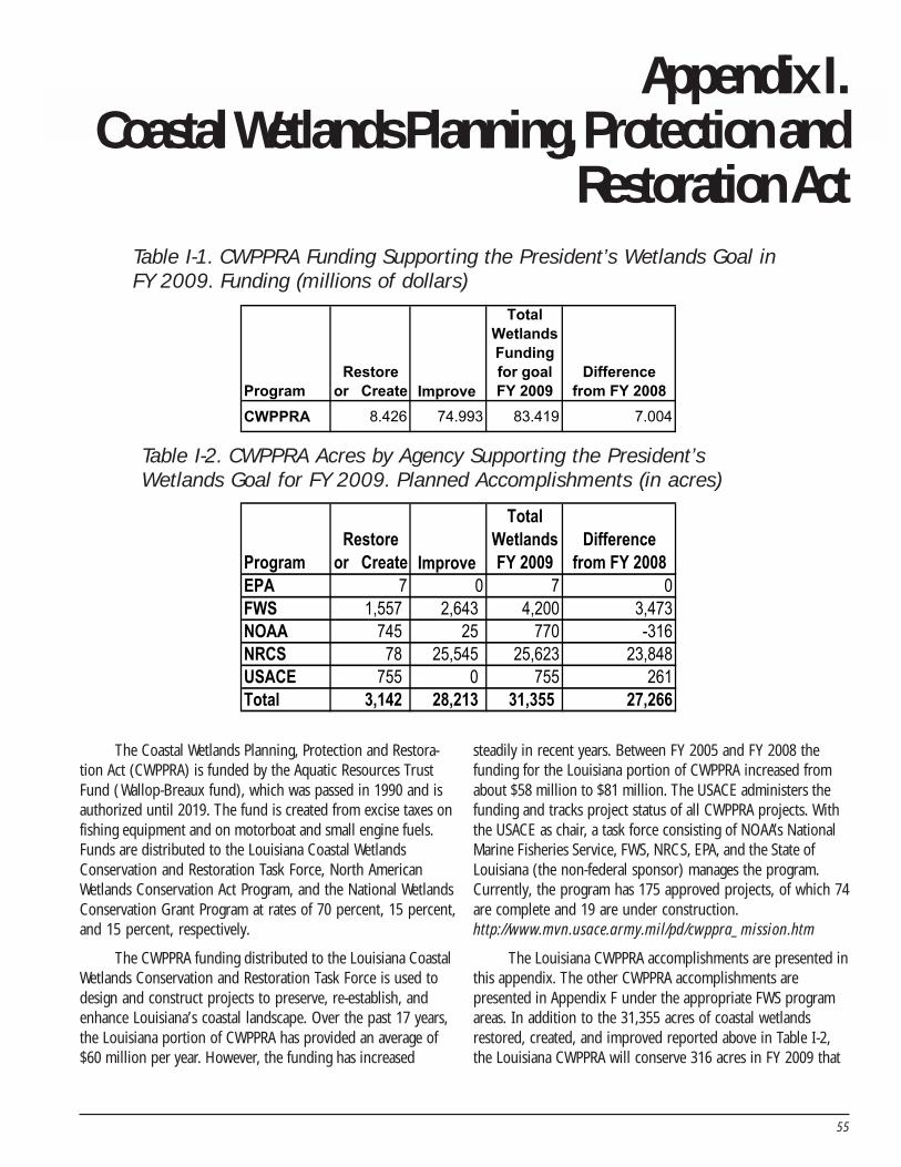
55
Appendix I.Coastal Wetlands Planning, Protection and
Restoration ActTable I-1. CWPPRA Funding Supporting the President’s Wetlands Goal inFY 2009. Funding (millions of dollars)
Program
Restore
or Create Improve
Total
Wetlands
Funding
for goal
FY 2009
Difference
from FY 2008
CWPPRA 8.426 74.993 83.419 7.004
Table I-2. CWPPRA Acres by Agency Supporting the President’sWetlands Goal for FY 2009. Planned Accomplishments (in acres)
Program
Restore
or Create Improve
Total
Wetlands
FY 2009
Difference
from FY 2008
EPA 7 0 7 0
FWS 1,557 2,643 4,200 3,473
NOAA 745 25 770 -316
NRCS 78 25,545 25,623 23,848
USACE 755 0 755 261
Total 3,142 28,213 31,355 27,266
The Coastal Wetlands Planning, Protection and Restora-tion Act (CWPPRA) is funded by the Aquatic Resources TrustFund ( Wallop-Breaux fund), which was passed in 1990 and isauthorized until 2019. The fund is created from excise taxes onfishing equipment and on motorboat and small engine fuels.Funds are distributed to the Louisiana Coastal WetlandsConservation and Restoration Task Force, North AmericanWetlands Conservation Act Program, and the National WetlandsConservation Grant Program at rates of 70 percent, 15 percent,and 15 percent, respectively.
The CWPPRA funding distributed to the Louisiana CoastalWetlands Conservation and Restoration Task Force is used todesign and construct projects to preserve, re-establish, andenhance Louisiana’s coastal landscape. Over the past 17 years,the Louisiana portion of CWPPRA has provided an average of$60 million per year. However, the funding has increased
steadily in recent years. Between FY 2005 and FY 2008 thefunding for the Louisiana portion of CWPPRA increased fromabout $58 million to $81 million. The USACE administers thefunding and tracks project status of all CWPPRA projects. Withthe USACE as chair, a task force consisting of NOAA’s NationalMarine Fisheries Service, FWS, NRCS, EPA, and the State ofLouisiana (the non-federal sponsor) manages the program.Currently, the program has 175 approved projects, of which 74are complete and 19 are under construction.http://www.mvn.usace.army.mil/pd/cwppra_mission.htm
The Louisiana CWPPRA accomplishments are presented inthis appendix. The other CWPPRA accomplishments arepresented in Appendix F under the appropriate FWS programareas. In addition to the 31,355 acres of coastal wetlandsrestored, created, and improved reported above in Table I-2,the Louisiana CWPPRA will conserve 316 acres in FY 2009 that
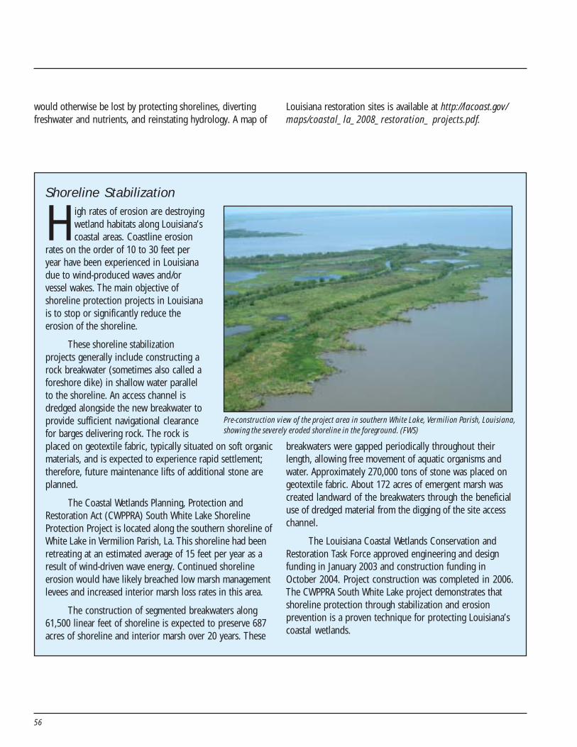
56
Shoreline Stabilization
High rates of erosion are destroyingwetland habitats along Louisiana’scoastal areas. Coastline erosion
rates on the order of 10 to 30 feet peryear have been experienced in Louisianadue to wind-produced waves and/orvessel wakes. The main objective ofshoreline protection projects in Louisianais to stop or significantly reduce theerosion of the shoreline.
These shoreline stabilizationprojects generally include constructing arock breakwater (sometimes also called aforeshore dike) in shallow water parallelto the shoreline. An access channel isdredged alongside the new breakwater toprovide sufficient navigational clearancefor barges delivering rock. The rock isplaced on geotextile fabric, typically situated on soft organicmaterials, and is expected to experience rapid settlement;therefore, future maintenance lifts of additional stone areplanned.
The Coastal Wetlands Planning, Protection andRestoration Act (CWPPRA) South White Lake ShorelineProtection Project is located along the southern shoreline ofWhite Lake in Vermilion Parish, La. This shoreline had beenretreating at an estimated average of 15 feet per year as aresult of wind-driven wave energy. Continued shorelineerosion would have likely breached low marsh managementlevees and increased interior marsh loss rates in this area.
The construction of segmented breakwaters along61,500 linear feet of shoreline is expected to preserve 687acres of shoreline and interior marsh over 20 years. These
breakwaters were gapped periodically throughout theirlength, allowing free movement of aquatic organisms andwater. Approximately 270,000 tons of stone was placed ongeotextile fabric. About 172 acres of emergent marsh wascreated landward of the breakwaters through the beneficialuse of dredged material from the digging of the site accesschannel.
The Louisiana Coastal Wetlands Conservation andRestoration Task Force approved engineering and designfunding in January 2003 and construction funding inOctober 2004. Project construction was completed in 2006.The CWPPRA South White Lake project demonstrates thatshoreline protection through stabilization and erosionprevention is a proven technique for protecting Louisiana’scoastal wetlands.
would otherwise be lost by protecting shorelines, divertingfreshwater and nutrients, and reinstating hydrology. A map of
Pre-construction view of the project area in southern White Lake, Vermilion Parish, Louisiana,showing the severely eroded shoreline in the foreground. (FWS)
Louisiana restoration sites is available at http://lacoast.gov/maps/coastal_la_2008_restoration_ projects.pdf.
57
AcronymsBLM Bureau of Land Management, DOICBBEP Coastal Bend Bays and Estuaries ProgramCEAP Conservation Effects Assessment Project, USDACELCP Coastal and Estuarine Land Conservation
Program, DOC/NOAACEQ Council on Environmental QualityCERCLA Comprehensive Environmental Response,
Compensation, and Liability Act of 1980CERP Comprehensive Everglades Restoration PlanCIAP Coastal Impact Assistance ProgramCREP Conservation Reserve Enhancement ProgramCRP/NOAA Community-based Restoration Program,
DOC/NOAACRP/FSA Conservation Reserve Program, USDA/FSACTA Conservation Technical Assistance Program,
USDA/NRCSCWA Clean Water ActCWPPRA Coastal Wetlands Planning, Protection and
Restoration ActCWRP Corporate Wetland Restoration Partnership,
USDA/Coastal AmericaCZM Coastal Zone Management Program, NOAADARRP Damage Assessment, Remediation, and
Restoration Program, DOC/NOAADOA Department of the ArmyDOC Department of CommerceDOI Department of the InteriorDOT Department of TransportationECOS Environmental Conservation Online System, DOI/
FWSEMAP Environmental Monitoring and Assessment
Program, EPAEPA Environmental Protection AgencyEQIP Environmental Quality Incentives Program,
USDA/NRCSERDC Engineer Research and Development Center,
DOA/USACEERP Environmental Restoration Program, DOA/USACEFAA Federal Aviation Administration, DOTFHWA Federal Highway Administration, DOT
FSA Farm Service Agency, USDAFWMA Fish and Wildlife Management AssistanceFWS Fish and Wildlife Service, DOIGAO Government Accountability Office, CongressGIS Geographic information systemHREP Habitat Rehabilitation and Enhancement Project,
DOA/USACEJVs Joint Venture Partnerships, DOI/FWSNAWCA North American Wetlands Conservation Act,
DOI/FWSNEP National Estuary Program, EPANERRS National Estuarine Research Reserve System,
DOC/NOAANOAA National Oceanic and Atmospheric
Administration, DOCNPS National Park Service, DOINRCS Natural Resources Conservation Service, USDANRDAR Natural Resource Damage Assessment and
Restoration, DOI/FWSNRI National Resources Inventory, USDA/NRCSNSDI National Spatial Data InfrastructureNWI National Wetlands Inventory, DOI/FWSNWRS National Wildlife Refuge System, DOI/FWSOMB Office of Management and BudgetOPA Oil Pollution Act of 1990PCSRF Pacific Coastal Salmon Recovery Fund,
DOC/NOAAPMC Plant Materials Center, USDA/NRCSSAFETEA Safe, Accountable, Flexible, Efficient
Transportation Equity ActUSACE U.S. Army Corps of Engineers, DOAUSBR U.S. Bureau of Reclamation, DOIUSDA U.S. Department of AgricultureUSFS U.S. Forest Service, USDAUSGS U.S. Geological Survey, DOIWHIP Wildlife Habitat Incentives Program,
USDA/NRCSWHWWG White House Wetlands Working GroupWRP Wetlands Reserve Program, USDA/NRCS

58