Embed Size (px)
Citation preview
APIRG/18 – WP/13 Appendix A
29/2/2012
CONSOLIDATED APIRG/17 CONCLUSIONS
Draft
Conclusions
No.
Title of Conclusions Text of Conclusions Follow-up Action To be
initiated by
Deliverable/
Intended
Outcome
Target
Dates
Status of
Implementation
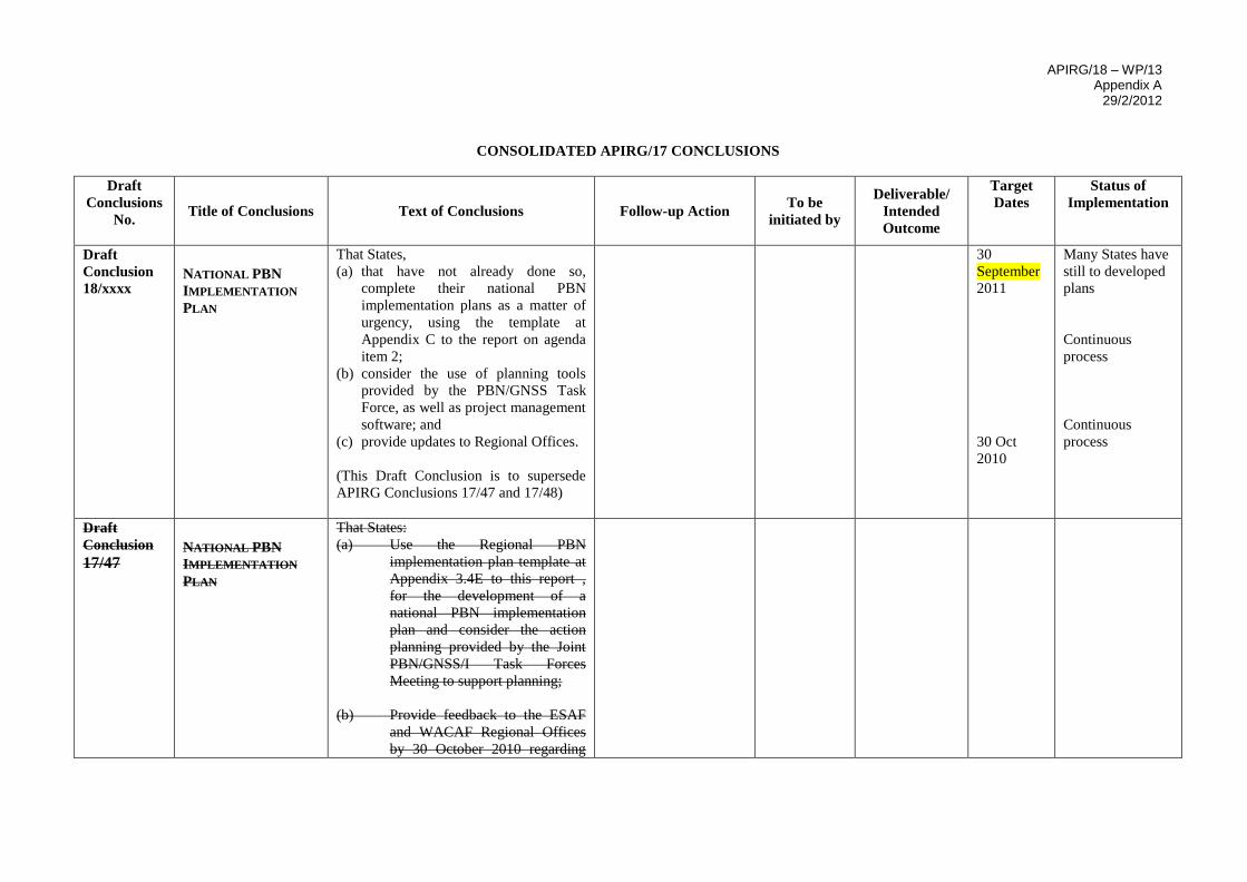
Draft
Conclusion
18/xxxx NATIONAL PBN
IMPLEMENTATION
PLAN
That States,
(a) that have not already done so,
complete their national PBN
implementation plans as a matter of
urgency, using the template at
Appendix C to the report on agenda
item 2;
(b) consider the use of planning tools
provided by the PBN/GNSS Task
Force, as well as project management
software; and
(c) provide updates to Regional Offices.
(This Draft Conclusion is to supersede
APIRG Conclusions 17/47 and 17/48)
30
September
2011
30 Oct
2010
Many States have
still to developed
plans
Continuous
process
Continuous
process
Draft
Conclusion
17/47 NATIONAL PBN
IMPLEMENTATION
PLAN
That States:
(a) Use the Regional PBN
implementation plan template at
Appendix 3.4E to this report ,
for the development of a
national PBN implementation
plan and consider the action
planning provided by the Joint
PBN/GNSS/I Task Forces
Meeting to support planning;
(b) Provide feedback to the ESAF
and WACAF Regional Offices
by 30 October 2010 regarding
APIRG/18 – WP/13 Appendix A
29/2/2012
-2-
2
Draft
Conclusions
No.
Title of Conclusions Text of Conclusions Follow-up Action To be
initiated by
Deliverable/
Intended
Outcome
Target
Dates
Status of
Implementation
progress in the development of
their national plans, indicating
any challenges, if any, that are
delaying the development of the
plan, as well as measures taken
or to be taken to overcome such
challenges; and
(c) Complete their National PBN
plans as soon as possible.
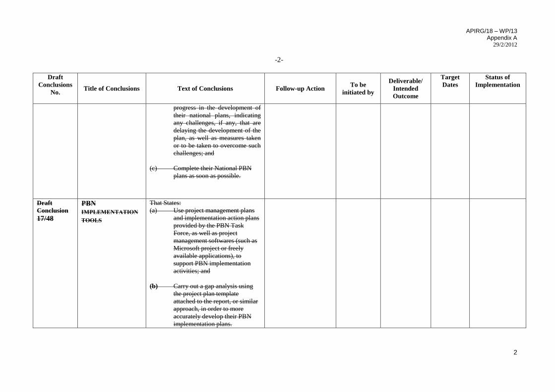
Draft
Conclusion
17/48
PBN
IMPLEMENTATION
TOOLS
That States:
(a) Use project management plans
and implementation action plans
provided by the PBN Task
Force, as well as project
management softwares (such as
Microsoft project or freely
available applications), to
support PBN implementation
activities; and
(b) Carry out a gap analysis using
the project plan template
attached to the report, or similar
approach, in order to more
accurately develop their PBN
implementation plans.
APIRG/18 – WP/13 Appendix A
29/2/2012
-3-
3
Draft
Conclusions
No.
Title of Conclusions Text of Conclusions Follow-up Action To be
initiated by
Deliverable/
Intended
Outcome
Target
Dates
Status of
Implementation
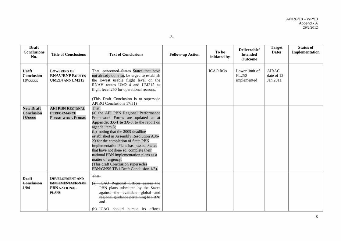
Draft
Conclusion
18/xxxxx
LOWERING OF
RNAV/RNP ROUTES
UM214 AND UM215
That, concerned States States that have
not already done so, be urged to establish
the lowest usable flight level on the
RNAV routes UM214 and UM215 as
flight level 250 for operational reasons.
(This Draft Conclusion is to supersede
APIRG Conclusions 17/51)
ICAO ROs
Lower limit of
FL250
implemented
AIRAC
date of 13
Jan 2011
New Draft
Conclusion
18/xxxx
AFI PBN REGIONAL
PERFORMANCE
FRAMEWORK FORMS
That;
(a) the AFI PBN Regional Performance
Framework Forms are updated as at
Appendix 3X-1 to 3X-3, to the report on
agenda item 3;
(b) noting that the 2009 deadline
established in Assembly Resolution A36-
23 for the completion of State PBN
implementation Plans has passed, States
that have not done so, complete their
national PBN implementation plans as a
matter of urgency.
(This draft Conclusion supersedes
PBN/GNSS TF/1 Draft Conclusion 1/3).
Draft
Conclusion
1/04
DEVELOPMENT AND
IMPLEMENTATION OF
PBN NATIONAL
PLANS
That:
(a) ICAO Regional Offices assess the
PBN plans submitted by the States
against the available global and
regional guidance pertaining to PBN;
and
(b) ICAO should pursue its efforts
APIRG/18 – WP/13 Appendix A
29/2/2012
-4-
4
Draft
Conclusions
No.
Title of Conclusions Text of Conclusions Follow-up Action To be
initiated by
Deliverable/
Intended
Outcome
Target
Dates
Status of
Implementation
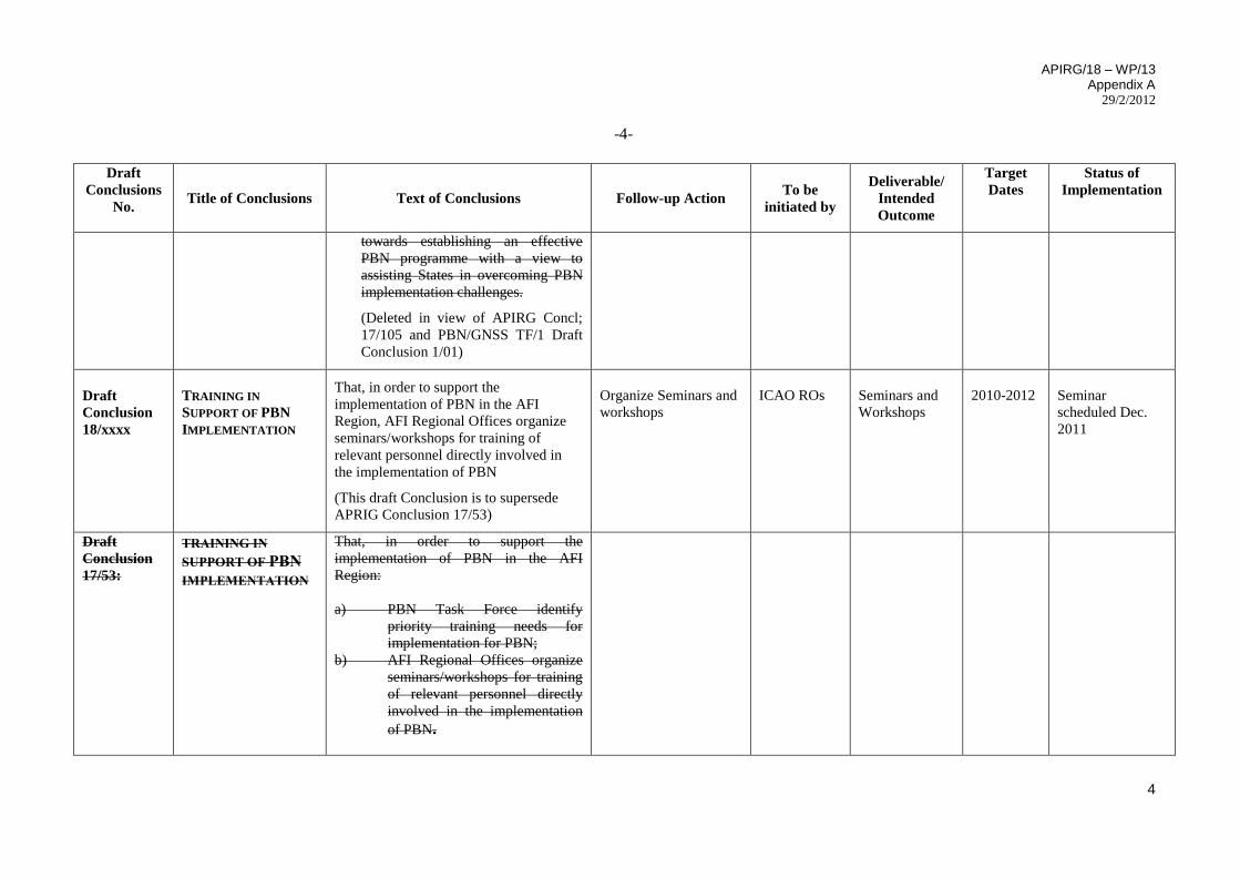
towards establishing an effective
PBN programme with a view to
assisting States in overcoming PBN
implementation challenges.
(Deleted in view of APIRG Concl;
17/105 and PBN/GNSS TF/1 Draft
Conclusion 1/01)
Draft
Conclusion
18/xxxx
TRAINING IN
SUPPORT OF PBN
IMPLEMENTATION
That, in order to support the
implementation of PBN in the AFI
Region, AFI Regional Offices organize
seminars/workshops for training of
relevant personnel directly involved in
the implementation of PBN
(This draft Conclusion is to supersede
APRIG Conclusion 17/53)
Organize Seminars and
workshops
ICAO ROs
Seminars and
Workshops
2010-2012
Seminar
scheduled Dec.
2011
Draft
Conclusion
17/53:
TRAINING IN
SUPPORT OF PBN
IMPLEMENTATION
That, in order to support the
implementation of PBN in the AFI
Region:
a) PBN Task Force identify
priority training needs for
implementation for PBN;
b) AFI Regional Offices organize
seminars/workshops for training
of relevant personnel directly
involved in the implementation
of PBN.
APIRG/18 – WP/13 Appendix A
29/2/2012
-5-
5
Draft
Conclusions
No.
Title of Conclusions Text of Conclusions Follow-up Action To be
initiated by
Deliverable/
Intended
Outcome
Target
Dates
Status of
Implementation
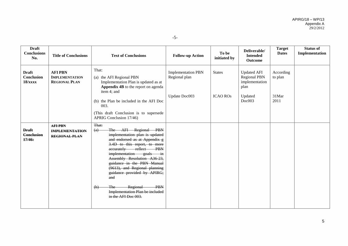
Draft
Conclusion
18/xxxx
AFI PBN
IMPLEMENTATION
REGIONAL PLAN
That:
(a) the AFI Regional PBN
Implementation Plan is updated as at
Appendix 4B to the report on agenda
item 4; and
(b) the Plan be included in the AFI Doc
003.
(This draft Conclusion is to supersede
APRIG Conclusion 17/46)
Implementation PBN
Regional plan
Update Doc003
States
ICAO ROs
Updated AFI
Regional PBN
implementation
plan
Updated
Doc003
According
to plan
31Mar
2011
Draft
Conclusion
17/46:
AFI PBN
IMPLEMENTATION
REGIONAL PLAN
That:
(a) The AFI Regional PBN
implementation plan is updated
and endorsed as at Appendix g
3.4D to this report, to more
accurately reflect PBN
implementation goals in
Assembly Resolution A36-23,
guidance in the PBN Manual
(9613), and Regional planning
guidance provided by APIRG;
and
(b) The Regional PBN
Implementation Plan be included
in the AFI Doc 003.
APIRG/18 – WP/13 Appendix A
29/2/2012
-6-
6
Draft
Conclusions
No.
Title of Conclusions Text of Conclusions Follow-up Action To be
initiated by
Deliverable/
Intended
Outcome
Target
Dates
Status of
Implementation
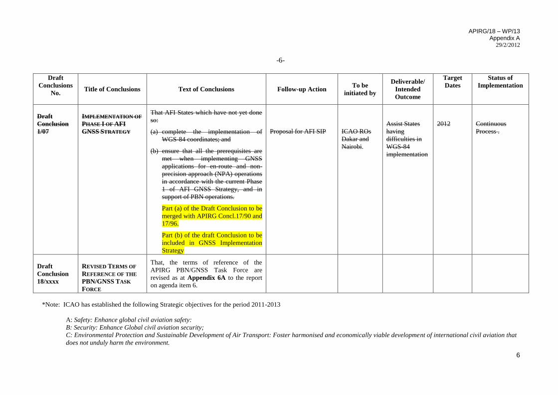
Draft
Conclusion
1/07
IMPLEMENTATION OF
PHASE I OF AFI
GNSS STRATEGY
That AFI States which have not yet done
so:
(a) complete the implementation of
WGS-84 coordinates; and
(b) ensure that all the prerequisites are
met when implementing GNSS
applications for en-route and non-
precision approach (NPA) operations
in accordance with the current Phase
1 of AFI GNSS Strategy, and in
support of PBN operations.
Part (a) of the Draft Conclusion to be
merged with APIRG Concl.17/90 and
17/96.
Part (b) of the draft Conclusion to be
included in GNSS Implementation
Strategy
Proposal for AFI SIP
ICAO ROs
Dakar and
Nairobi.
Assist States
having
difficulties in
WGS-84
implementation
2012
Continuous
Process .
Draft
Conclusion
18/xxxx
REVISED TERMS OF
REFERENCE OF THE
PBN/GNSS TASK
FORCE
That, the terms of reference of the
APIRG PBN/GNSS Task Force are
revised as at Appendix 6A to the report
on agenda item 6.
*Note: ICAO has established the following Strategic objectives for the period 2011-2013
A: Safety: Enhance global civil aviation safety:
B: Security: Enhance Global civil aviation security;
C: Environmental Protection and Sustainable Development of Air Transport: Foster harmonised and economically viable development of international civil aviation that
does not unduly harm the environment.
APIRG/18 – WP/13
Appendix B 29/2/2012
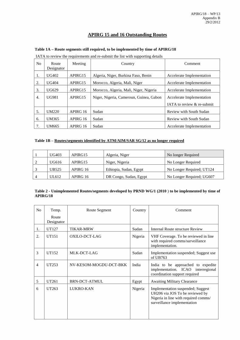
APIRG 15 and 16 Outstanding Routes
Table 1A – Route segments still required, to be implemented by time of APIRG/18
IATA to review the requirements and re-submit the list with supporting details
No Route
Designator
Meeting Country Comment
1. UG402 APIRG15 Algeria, Niger, Burkina Faso, Benin Accelerate Implementation
2. UG404 APIRG15 Morocco, Algeria, Mali, Niger Accelerate Implementation
3. UG629 APIRG15 Morocco, Algeria, Mali, Niger, Nigeria Accelerate Implementation
4. UG981 APIRG15 Niger, Nigeria, Cameroun, Guinea, Gabon Accelerate Implementation
IATA to review & re-submit
5. UM220 APIRG 16 Sudan Review with South Sudan
6. UM365 APIRG 16 Sudan Review with South Sudan
7. UM665 APIRG 16 Sudan Accelerate Implementation
Table 1B – Routes/segments identified by ATM/AIM/SAR SG/12 as no longer required
1 UG403 APIRG15 Algeria, Niger No longer Required
2 UG616 APIRG15 Niger, Nigeria No Longer Required
3 UB525 APIRG 16 Ethiopia, Sudan, Egypt No Longer Required; UT124
4 UL612 APIRG 16 DR Congo, Sudan, Egypt No Longer Required; UG607
Table 2 - Unimplemented Routes/segments developed by PRND WG/1 (2010 ) to be implemented by time of
APIRG/18
No Temp.
Route
Designator
Route Segment Country Comment
1. UT127 TIKAR-MRW Sudan Internal Route structure Review
2. UT151 OXILO-DCT-LAG Nigeria VHF Coverage. To be reviewed in line
with required comms/surveillance
implementation.
3 UT152 MLK-DCT-LAG Sudan Implementation suspended; Suggest use
of UB763
4 UT253 NV-KESOM-MOGDU-DCT-BKK India India to be approached to expedite
implementation. ICAO interregional
coordination support required
5 UT261 BRN-DCT-ATMUL Egypt Awaiting Military Clearance
6 UT263 LUKRO-KAN Nigeria Implementation suspended; Suggest
UH206 via JOS To be reviewed by
Nigeria in line with required comms/
surveillance implementation
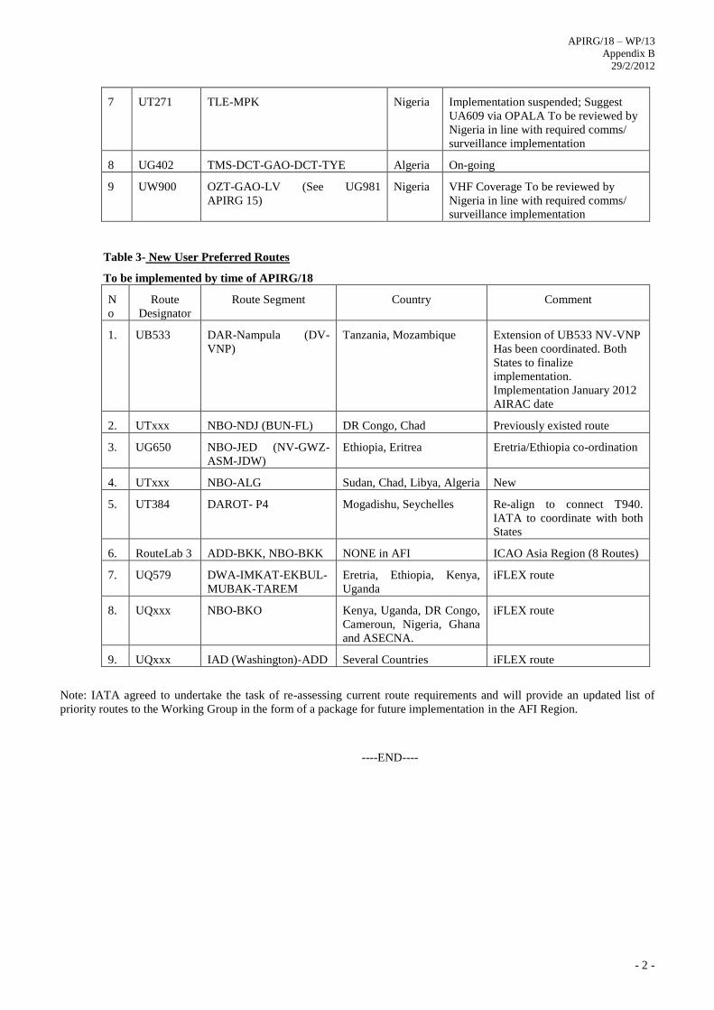
APIRG/18 – WP/13
Appendix B 29/2/2012
- 2 -
7 UT271 TLE-MPK Nigeria Implementation suspended; Suggest
UA609 via OPALA To be reviewed by
Nigeria in line with required comms/
surveillance implementation
8 UG402 TMS-DCT-GAO-DCT-TYE Algeria On-going
9 UW900 OZT-GAO-LV (See UG981
APIRG 15)
Nigeria VHF Coverage To be reviewed by
Nigeria in line with required comms/
surveillance implementation
Table 3- New User Preferred Routes
To be implemented by time of APIRG/18
N
o
Route
Designator
Route Segment Country Comment
1. UB533 DAR-Nampula (DV-
VNP)
Tanzania, Mozambique Extension of UB533 NV-VNP
Has been coordinated. Both
States to finalize
implementation.
Implementation January 2012
AIRAC date
2. UTxxx NBO-NDJ (BUN-FL) DR Congo, Chad Previously existed route
3. UG650 NBO-JED (NV-GWZ-
ASM-JDW)
Ethiopia, Eritrea Eretria/Ethiopia co-ordination
4. UTxxx NBO-ALG Sudan, Chad, Libya, Algeria New
5. UT384 DAROT- P4 Mogadishu, Seychelles Re-align to connect T940.
IATA to coordinate with both
States
6. RouteLab 3 ADD-BKK, NBO-BKK NONE in AFI ICAO Asia Region (8 Routes)
7. UQ579 DWA-IMKAT-EKBUL-
MUBAK-TAREM
Eretria, Ethiopia, Kenya,
Uganda
iFLEX route
8. UQxxx NBO-BKO Kenya, Uganda, DR Congo,
Cameroun, Nigeria, Ghana
and ASECNA.
iFLEX route
9. UQxxx IAD (Washington)-ADD Several Countries iFLEX route
Note: IATA agreed to undertake the task of re-assessing current route requirements and will provide an updated list of
priority routes to the Working Group in the form of a package for future implementation in the AFI Region.
----END----
APIRG/18 – WP/13
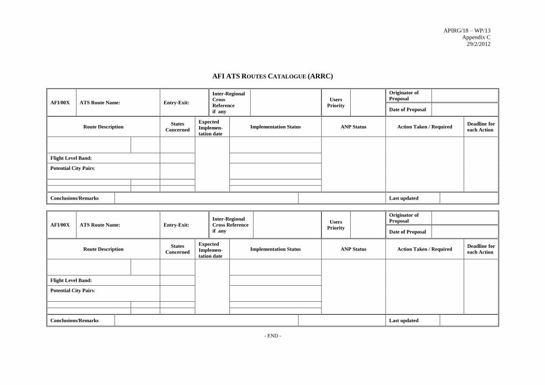
Appendix C 29/2/2012
AFI ATS ROUTES CATALOGUE (ARRC)
AFI/00X ATS Route Name: Entry-Exit:
Inter-Regional
Cross
Reference
if any
Users
Priority
Originator of
Proposal
Date of Proposal
Route Description States
Concerned
Expected
Implemen-
tation date
Implementation Status ANP Status Action Taken / Required Deadline for
each Action
Flight Level Band:
Potential City Pairs:
Conclusions/Remarks Last updated
AFI/00X ATS Route Name: Entry-Exit:
Inter-Regional
Cross Reference
if any
Users
Priority
Originator of
Proposal
Date of Proposal
Route Description States
Concerned
Expected
Implemen-
tation date
Implementation Status ANP Status Action Taken / Required Deadline for
each Action
Flight Level Band:
Potential City Pairs:
Conclusions/Remarks Last updated
- END -
APIRG/18 – WP/13
Appendix D 29/2/2012
______________________________________________________________________________
Page 1 of 2
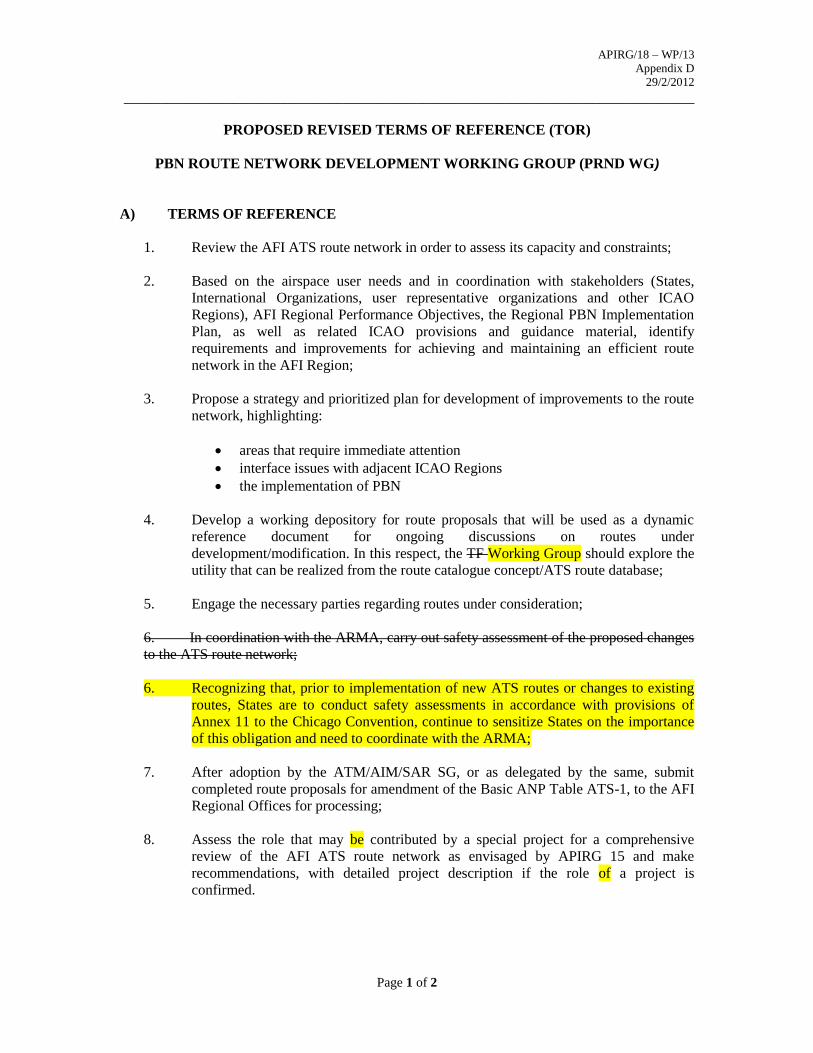
PROPOSED REVISED TERMS OF REFERENCE (TOR)
PBN ROUTE NETWORK DEVELOPMENT WORKING GROUP (PRND WG)
A) TERMS OF REFERENCE
1. Review the AFI ATS route network in order to assess its capacity and constraints;
2. Based on the airspace user needs and in coordination with stakeholders (States,
International Organizations, user representative organizations and other ICAO
Regions), AFI Regional Performance Objectives, the Regional PBN Implementation
Plan, as well as related ICAO provisions and guidance material, identify
requirements and improvements for achieving and maintaining an efficient route
network in the AFI Region;
3. Propose a strategy and prioritized plan for development of improvements to the route
network, highlighting:
areas that require immediate attention
interface issues with adjacent ICAO Regions
the implementation of PBN
4. Develop a working depository for route proposals that will be used as a dynamic
reference document for ongoing discussions on routes under
development/modification. In this respect, the TF Working Group should explore the
utility that can be realized from the route catalogue concept/ATS route database;
5. Engage the necessary parties regarding routes under consideration;
6. In coordination with the ARMA, carry out safety assessment of the proposed changes
to the ATS route network;
6. Recognizing that, prior to implementation of new ATS routes or changes to existing
routes, States are to conduct safety assessments in accordance with provisions of
Annex 11 to the Chicago Convention, continue to sensitize States on the importance
of this obligation and need to coordinate with the ARMA;
7. After adoption by the ATM/AIM/SAR SG, or as delegated by the same, submit
completed route proposals for amendment of the Basic ANP Table ATS-1, to the AFI
Regional Offices for processing;
8. Assess the role that may be contributed by a special project for a comprehensive
review of the AFI ATS route network as envisaged by APIRG 15 and make
recommendations, with detailed project description if the role of a project is
confirmed.
APIRG/18 – WP/13
Appendix D 29/2/2012
______________________________________________________________________________
Page 2 of 2
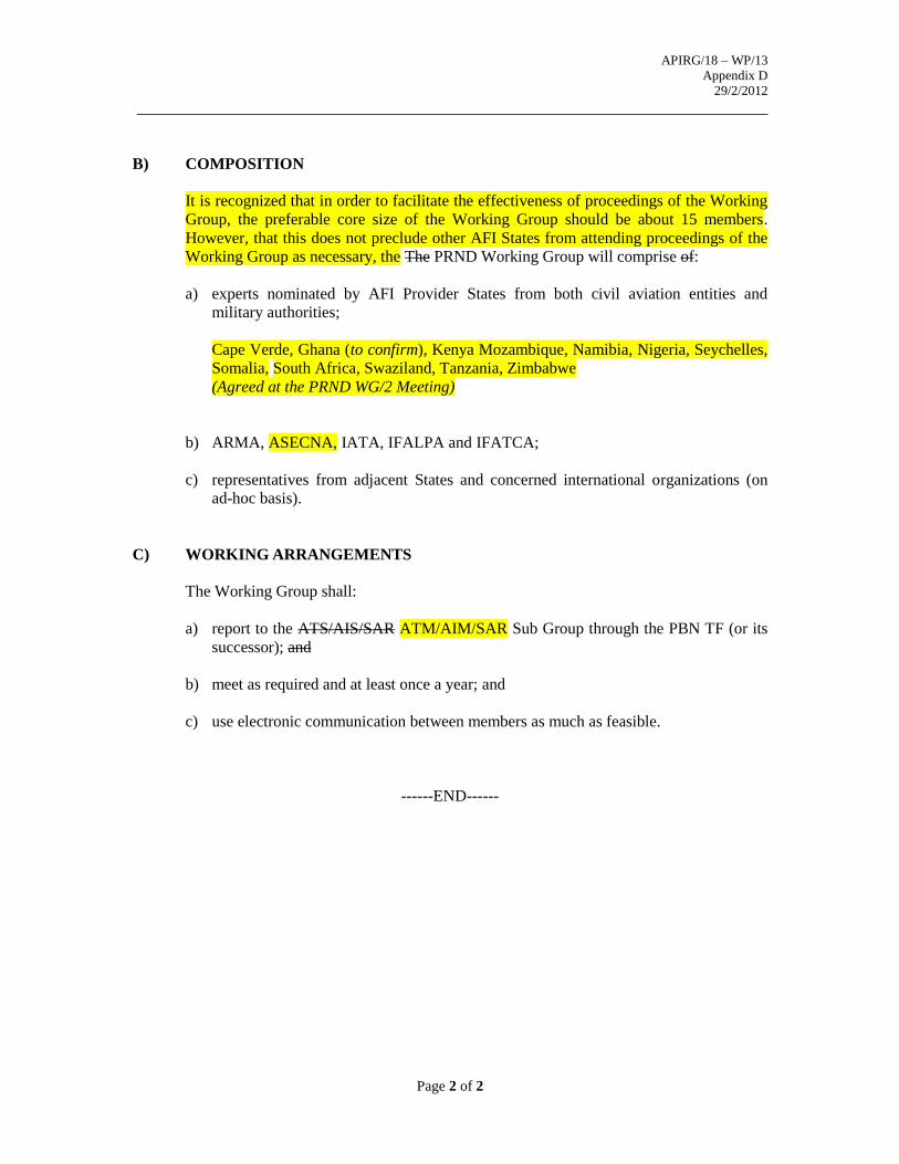
B) COMPOSITION
It is recognized that in order to facilitate the effectiveness of proceedings of the Working
Group, the preferable core size of the Working Group should be about 15 members.
However, that this does not preclude other AFI States from attending proceedings of the
Working Group as necessary, the The PRND Working Group will comprise of:
a) experts nominated by AFI Provider States from both civil aviation entities and
military authorities;
Cape Verde, Ghana (to confirm), Kenya Mozambique, Namibia, Nigeria, Seychelles,
Somalia, South Africa, Swaziland, Tanzania, Zimbabwe
(Agreed at the PRND WG/2 Meeting)
b) ARMA, ASECNA, IATA, IFALPA and IFATCA;
c) representatives from adjacent States and concerned international organizations (on
ad-hoc basis).
C) WORKING ARRANGEMENTS
The Working Group shall:
a) report to the ATS/AIS/SAR ATM/AIM/SAR Sub Group through the PBN TF (or its
successor); and
b) meet as required and at least once a year; and
c) use electronic communication between members as much as feasible.
------END------
APIRG/18 – WP/13 Appendix E
29/2/2012
ARMA/01/01 Page 1 of 5 25 July 2011
AFI RVSM SAFETY POLICY
JULY 2011
APIRG/18 – WP/13 Appendix E
29/2/2012
ARMA/01/01 Page 4 of 5 25 July 2011
2
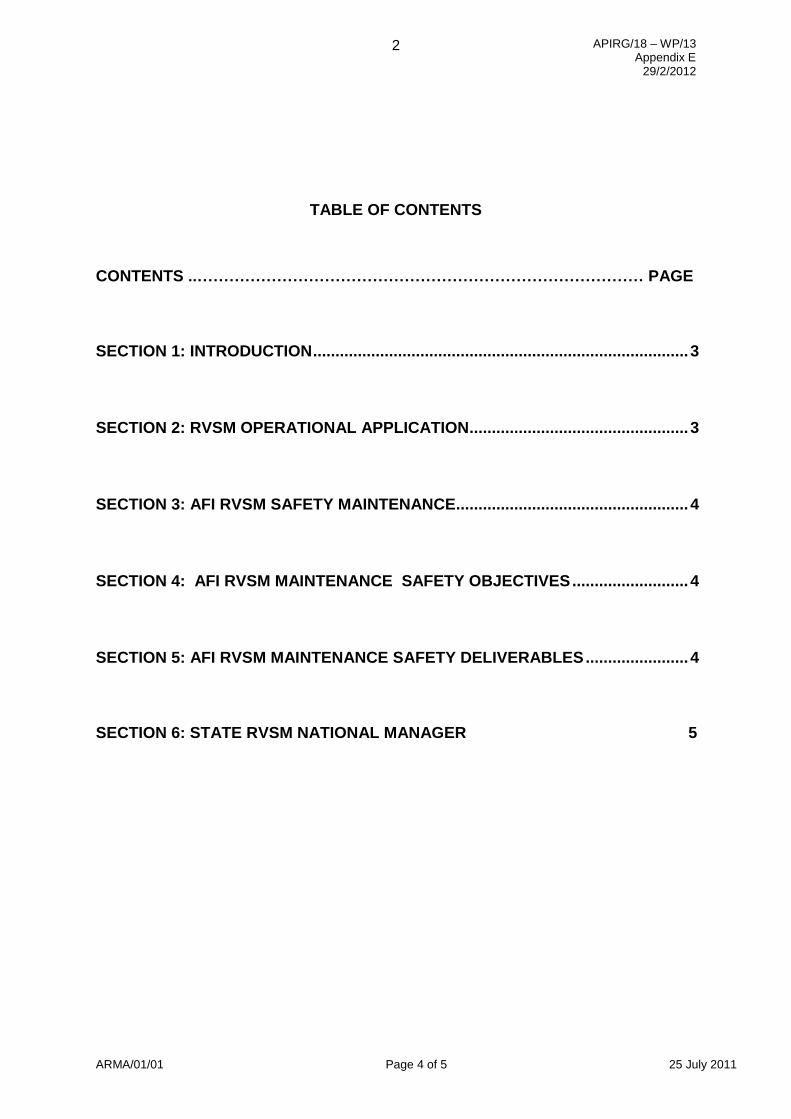
TABLE OF CONTENTS
CONTENTS ..………………………………………………………………………… PAGE
SECTION 1: INTRODUCTION .................................................................................... 3
SECTION 2: RVSM OPERATIONAL APPLICATION ................................................. 3
SECTION 3: AFI RVSM SAFETY MAINTENANCE.................................................... 4
SECTION 4: AFI RVSM MAINTENANCE SAFETY OBJECTIVES .......................... 4
SECTION 5: AFI RVSM MAINTENANCE SAFETY DELIVERABLES ....................... 4
SECTION 6: STATE RVSM NATIONAL MANAGER 5
APIRG/18 – WP/13 Appendix E
29/2/2012
3
ARMA/01/01 Page 5 of 5 25 July 2011
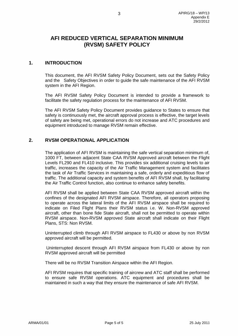
AFI REDUCED VERTICAL SEPARATION MINIMUM
(RVSM) SAFETY POLICY
1. INTRODUCTION
This document, the AFI RVSM Safety Policy Document, sets out the Safety Policy and the Safety Objectives in order to guide the safe maintenance of the AFI RVSM system in the AFI Region.
The AFI RVSM Safety Policy Document is intended to provide a framework to facilitate the safety regulation process for the maintenance of AFI RVSM.
The AFI RVSM Safety Policy Document provides guidance to States to ensure that safety is continuously met, the aircraft approval process is effective, the target levels of safety are being met, operational errors do not increase and ATC procedures and equipment introduced to manage RVSM remain effective.
2. RVSM OPERATIONAL APPLICATION
The application of AFI RVSM is maintaining the safe vertical separation minimum of, 1000 FT, between adjacent State CAA RVSM Approved aircraft between the Flight Levels FL290 and FL410 inclusive. This provides six additional cruising levels to air traffic, increases the capacity of the Air Traffic Management system and facilitates the task of Air Traffic Services in maintaining a safe, orderly and expeditious flow of traffic. The additional capacity and system benefits of AFI RVSM shall, by facilitating the Air Traffic Control function, also continue to enhance safety benefits.
AFI RVSM shall be applied between State CAA RVSM approved aircraft within the confines of the designated AFI RVSM airspace. Therefore, all operators proposing to operate across the lateral limits of the AFI RVSM airspace shall be required to indicate on Filed Flight Plans their RVSM status i.e. W. Non-RVSM approved aircraft, other than bone fide State aircraft, shall not be permitted to operate within RVSM airspace. Non-RVSM approved State aircraft shall indicate on their Flight Plans, STS: Non RVSM.
Uninterrupted climb through AFI RVSM airspace to FL430 or above by non RVSM approved aircraft will be permitted.
Uninterrupted descent through AFI RVSM airspace from FL430 or above by non RVSM approved aircraft will be permitted
There will be no RVSM Transition Airspace within the AFI Region.
AFI RVSM requires that specific training of aircrew and ATC staff shall be performed to ensure safe RVSM operations. ATC equipment and procedures shall be maintained in such a way that they ensure the maintenance of safe AFI RVSM.
APIRG/18 – WP/13 Appendix E
29/2/2012
ARMA/01/01 Page 4 of 5 25 July 2011
4
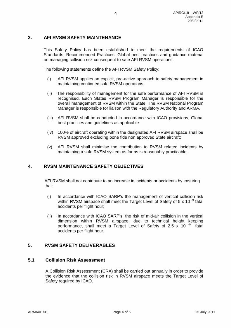
3. AFI RVSM SAFETY MAINTENANCE
This Safety Policy has been established to meet the requirements of ICAO Standards, Recommended Practices, Global best practices and guidance material on managing collision risk consequent to safe AFI RVSM operations.
The following statements define the AFI RVSM Safety Policy:
(i) AFI RVSM applies an explicit, pro-active approach to safety management in maintaining continued safe RVSM operations.
(ii) The responsibility of management for the safe performance of AFI RVSM is recognised. Each States RVSM Program Manager is responsible for the overall management of RVSM within the State. The RVSM National Program Manager is responsible for liaison with the Regulatory Authority and ARMA.
(iii) AFI RVSM shall be conducted in accordance with ICAO provisions, Global best practices and guidelines as applicable.
(iv) 100% of aircraft operating within the designated AFI RVSM airspace shall be RVSM approved excluding bone fide non approved State aircraft;
(v) AFI RVSM shall minimise the contribution to RVSM related incidents by maintaining a safe RVSM system as far as is reasonably practicable.
4. RVSM MAINTENANCE SAFETY OBJECTIVES
AFI RVSM shall not contribute to an increase in incidents or accidents by ensuring that:
(i) In accordance with ICAO SARP’s the management of vertical collision risk within RVSM airspace shall meet the Target Level of Safety of 5 x 10 -9 fatal accidents per flight hour;
(ii) In accordance with ICAO SARP’s, the risk of mid-air collision in the vertical dimension within RVSM airspace, due to technical height keeping performance, shall meet a Target Level of Safety of 2.5 x 10 -9 fatal accidents per flight hour.
5. RVSM SAFETY DELIVERABLES
5.1 Collision Risk Assessment
A Collision Risk Assessment (CRA) shall be carried out annually in order to provide the evidence that the collision risk in RVSM airspace meets the Target Level of Safety required by ICAO.
APIRG/18 – WP/13 Appendix E
29/2/2012
5
ARMA/01/01 Page 5 of 5 25 July 2011
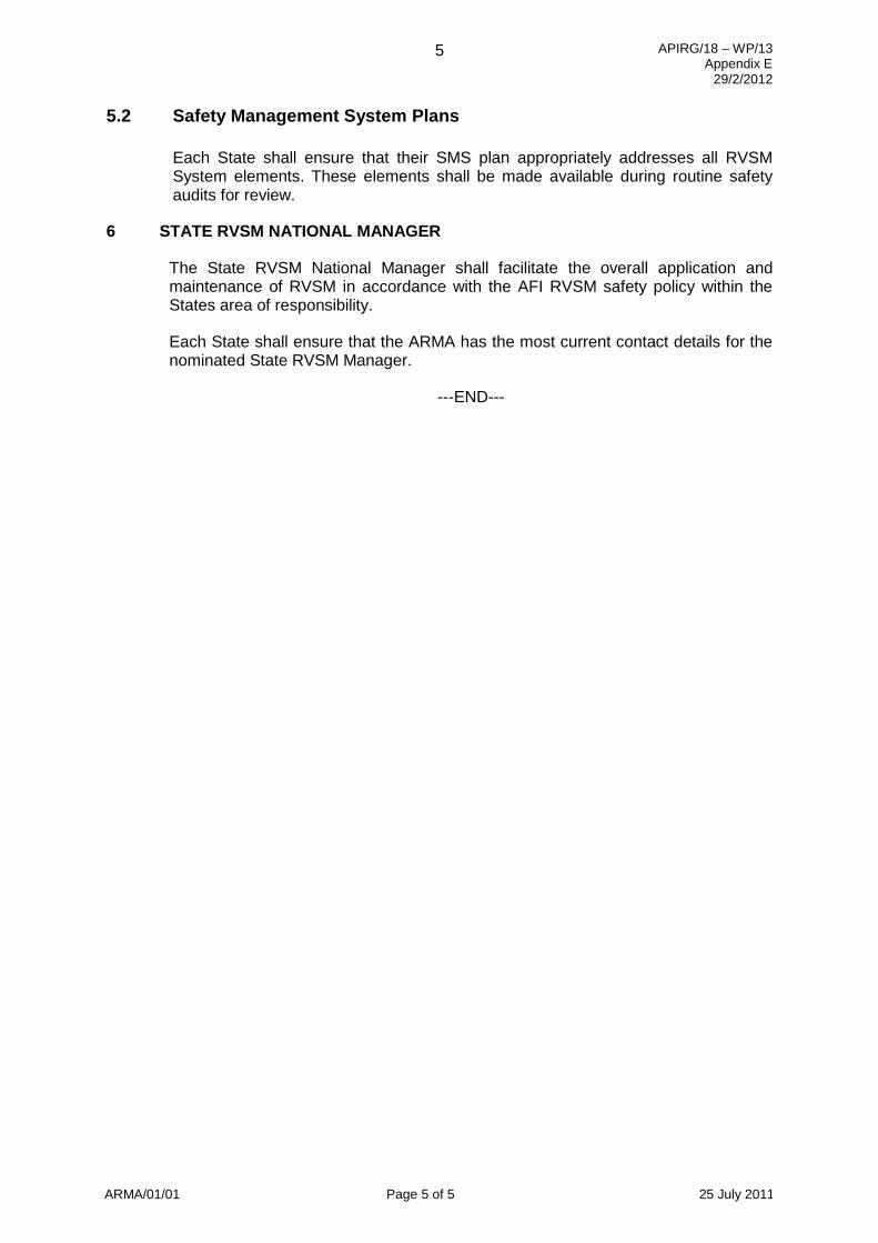
5.2 Safety Management System Plans
Each State shall ensure that their SMS plan appropriately addresses all RVSM System elements. These elements shall be made available during routine safety audits for review.
6 STATE RVSM NATIONAL MANAGER
The State RVSM National Manager shall facilitate the overall application and maintenance of RVSM in accordance with the AFI RVSM safety policy within the States area of responsibility.
Each State shall ensure that the ARMA has the most current contact details for the nominated State RVSM Manager.
---END---
APIRG/18 – WP/13
Appendix F
20/02/2012
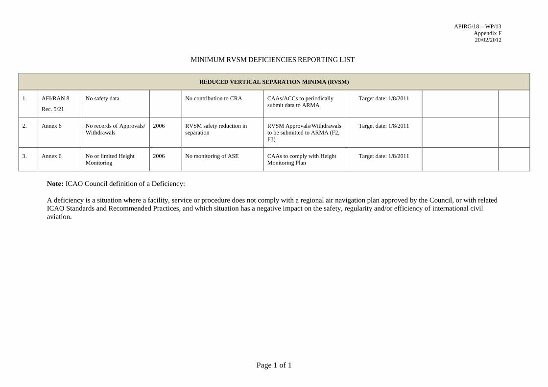
MINIMUM RVSM DEFICIENCIES REPORTING LIST
Page 1 of 1
REDUCED VERTICAL SEPARATION MINIMA (RVSM)
1. AFI/RAN 8
Rec. 5/21
No safety data No contribution to CRA CAAs/ACCs to periodically
submit data to ARMA
Target date: 1/8/2011
2. Annex 6 No records of Approvals/
Withdrawals
2006 RVSM safety reduction in
separation
RVSM Approvals/Withdrawals
to be submitted to ARMA (F2,
F3)
Target date: 1/8/2011
3. Annex 6 No or limited Height
Monitoring
2006 No monitoring of ASE CAAs to comply with Height
Monitoring Plan
Target date: 1/8/2011
Note: ICAO Council definition of a Deficiency:
A deficiency is a situation where a facility, service or procedure does not comply with a regional air navigation plan approved by the Council, or with related
ICAO Standards and Recommended Practices, and which situation has a negative impact on the safety, regularity and/or efficiency of international civil
aviation.
APIRG/18 – WP/13
Appendix G 29/2/2012
_________________________________________________________________________________
1
TERMS OF REFERENCE (TOR) OF THE
AFI AIR TRAFFIC MANAGEMENT/METEOROLOGY (AFI ATM/MET) TASK FORCE
1. Terms of Reference
1.1 Under guidance from ICAO Secretariat:
a) Evaluate the current and future requirements for MET in support of ATM in the AFI Region
and update Regional Air Navigation Plan accordingly and provide guidance material to assist
States to develop MET services to meet these requirements;
b) Assess aviation meteorological services, systems and architecture in the region and how they
can integrate weather information into decision support tools;
c) Review and update the AFI Volcanic Ash Contingency Plan (VACP) and monitor VACP
exercises;
d) Investigate sub-regional exchange of MET information and associated agreements that
facilitate ATM operations particularly over busy routes that overlap different FIRs;
e) Promote coordination between MET and ATM communities in the AFI Region to enhance the
level of understanding of MET requirements and capabilities in support of ATM;
f) Monitor global policy associated with source data and delivery of MET products for ATM;
g) Coordinate with MET/SG and ATM/AIS/SAR/SG on framework for contingency plan for
specific phenomenon including volcanic ash, radioactive cloud, tropical cyclone and Tsunami
with reference to developments made WMO scientific steering committee;
h) Report to the MET/SG Sub-group of APIRG for further co-ordination through the ICAO
Secretariat with other relevant bodies.
1.2 The objective being to improve efficiency of ATM and airlines by providing tailored regional
MET products needed to optimize flight routes in all weather conditions.
1.3 The Benefits will be to increase efficiency – save time and fuel as well as reduce carbon emissions.
2. Work Programme
2.1 The work to be addressed by the AFI ATM/MET Task Force includes:
a) Develop regional MET requirements for ATM by:
conducting MET/ATM meetings (TF meetings, Seminars) to contribute in developing
MET requirements for ATM;
analyzing existing ATM/MET surveys and develop new surveys, when necessary, to
determine regional ATM requirements for MET;
recommending regional MET requirements for ATM to MET/SG Meetings;
Determining regional MET requirements for ATM.
APIRG/18 – WP/13
Appendix G 29/2/2012
b) Developing methods to use weather information in decision support tools;
c) Review and update the AFI Volcanic Ash Contingency Plan (VACP) by:
Regularly updating the VACP through new requirements from the IAVWOPSG
Conducting annual VACP exercises or AFI ATM/MET Volcanic Ash Exercises
(VAEX/AFI);
reporting on annual VAEX/AFI to MET/SG meetings.
d) Develop sub-regional exchange of MET information to facilitate ATM operations by:
Encouraging States develop agreements on the exchange of MET information that
provides benefits to ATM operations on sub-regional level;
Encouraging States report developments to MET/ATM TF and MET/SG meetings;
Developing sub-regional exchange of MET information to facilitate ATM operations in
busy routes.
e) Develop regional implementation plan for Meteorological Service for Terminal Area (MSTA)
by:
Monitoring developments of MSTA (pending approval at conjoint ICAO/WMO
Divisional meeting 2014);
Monitoring ICAO Annex 3 developments (requirements for MSTA);
Developing regional implementation plan for MSTA ;
Monitoring regional implementation of MSTA;
Reporting implementation progress to MET/SG.
Developing regional implementation plan for Meteorological Services for the Terminal
Area.
f) Monitor global policies associated with source data and delivery of MET products for ATM by:
monitoring global policies associated with source data and delivery of MET products for
ATM ;
reporting results to MET/SG meetings;
monitor global policies associated with source data and delivery of MET products for
ATM.
3. Composition
3.1 The Task Force is composed of experts from:
a) South Africa, Senegal, France, Kenya, Gambia and Morocco.
b) Representatives of VAAC Toulouse, ASECNA, IATA, IFALPA and WMO are expected to
participate in the work of the Task Force.
---END---
APIRG/18 – WP/13
Appendix H 29/2/2012
Page 1
INTERNATIONAL CIVIL AVIATION ORGANIZATION
VOLCANIC ASH CONTINGENCY PLAN
AFI REGION
First Edition - April 2011
THIS DOCUMENT IS ISSUED BY THE WACAF AND NAIROBI OFFICES OF ICAO
UNDER THE AUTHORITY OF THE APIRG
APIRG/18 – WP/13
Appendix H 29/2/2012
____________________________________________________________________________________________________
TABLE OF CONTENTS
FOREWARD ................................................................................................................................................... 3
1. ALERTING PHASE .................................................................................................................................. 6
2. REACTIVE PHASE ................................................................................................................................ 7
3. PROACTIVE PHASE ............................................................................................................................... 8
4. AIR TRAFFIC CONTROL PROCEDURES ............................................................................................ 9
ATTACHMENT A - ANTICIPATED PILOT ISSUES WHEN ENCOUNTERING VOLCANIC ASH .... 13
ATTACHMENT B - ACTION TAKEN BY METEOROLOGICAL WATCH OFFICES (MWO) ............. 15
ATTACHMENT C - ACTION TO BE TAKEN BY THE AFI VAAC IN THE EVENT OF A
VOLCANIC ERUPTION .............................................................................................................................. 16
ATTACHMENT D - PROCEDURES FOR THE PRODUCTION OF MODELLED ASH
CONCENTRATION CHARTS ..................................................................................................................... 17
ATTACHMENT E - EXAMPLE SIGMET, NOTAM, ASHTAM ............................................................... 18
ATTACHMENT F – MAJOR VOLCANOES IN THE AFI REGION ......................................................... 21
APIRG/18 – WP/13
Appendix H 29/2/2012
____________________________________________________________________________________________________
FOREWARD
Within and adjacent to the Africa and Indian Ocean (AFI) Region there are areas of volcanic activities
which are likely to affect flight in the AFI Region. The major volcanoes in the region are located in
the following States: Algeria, Cameroon, Cape Verde Islands, Chad, Comoros Island, Democratic
Republic of Congo, Djibouti, Eritrea, Ethiopia, France (Reunion Island), Kenya, Madagascar, Mali,
Niger, Nigeria, Rwanda, Sao Tome and Principe, Spain (Canary Islands, Madeira), Sudan, Tanzania
and Uganda. The names of the concerned volcano are listed in Attachment F (source: Smithsonian
Institution).
The AFI Volcanic Ash Contingency Plan sets out standardised guidelines for the alerting of aircraft
when eruptions occur, and procedures to be followed.
Volcanic ash is a hazard for flight operations. Recent encounters with volcanic ash have resulted in
one or more of the following and other problems:
Engine failures and malfunctions;
Subsequent failure of electrical, pneumatical and hydraulic systems;
Blocking of sensors, resulting inter alia in erroneous airspeed indications;
Smoke, dust and/or chemical pollution of cabin air; resulting in the need for aircrews to use
oxygen masks;
Communication problems;
Loss of visibility through cockpit windows.
Regulatory authorities of States of the Operator1, or State of Registry
2as appropriate, should therefore
prescribe appropriate operational procedures for flight crew to be followed in case of operation in or
near airspaces that are contaminated by volcanic ash. Operators are required by ICAO Annex 6 to
assess the risk of operation in volcanic ash and to implement appropriate mitigation measures in
accordance with their Safety Management System as approved by the State of the Operator.
It should be noted that this document is an air traffic management (ATM) contingency plan including
its interfaces with supporting services such as MET and AIS and that the Plan therefore primarily
addresses the Provider States3. Where distinct actions by the Meteorological Watch Offices (MWOs)
are described, these are additional procedures to be considered by MWOs. Where actions by
Volcanic Ash Advisory Centre (VAAC) and Aircraft Operators are described, these are for
clarification only.
Volcanic Ash can also affect the operation of aircraft on aerodromes. In extreme cases, aerodromes
might no longer be available for operation at all, resulting in repercussions on the Air Traffic
Management systems; e.g. diversions, revised traffic flow, etc.
These suggested procedures are not intended to establish or confirm a safe level of ash concentration.
Operation through any area where volcanic ash is forecast is at the discretion of the operator.
NOTE: All modeled ash concentrations are subject to a level of uncertainty relative to errors in
the estimation of the eruption strength.
1 The term “State of the Operator” refers to the role of a Contracting State as the regulatory authority with regard to aircraft
operators having been issued an Aircraft Operator’s Certificate (AOC) by that` State.
2 The term “State of Registry” refers to the State on whose register the aircraft is entered.
3 The term “Provider State” refers to the role of a Contracting State as responsible for the provision of air navigation services
within airspace over its territory and, as agreed by Regional Air Navigation Meeting, within defined airspace over the High
Seas.
APIRG/18 – WP/13
Appendix H 29/2/2012
____________________________________________________________________________________________________
Considering that a commercial aircraft will travel about 150 km (80 NM) in 10 minutes and that
volcanic ash can rise to flight levels commonly used by turbine-engine aeroplanes in half that time,
timely response to reports of volcanic ash is essential.
It is imperative that information on the volcanic activity is disseminated as soon as possible. In order
to assist the staff in expediting the process in originating and issuing relevant messages (SIGMET,
NOTAM, ASHTAM), a series of templates should be available for different stages of the volcanic
activity. Examples of SIGMET, NOTAM and ASHTAM announcing volcanic activities in the
different stages and operational measures are contained in Attachment E. ASHTAM is promulgated
by service providers in the AFI Region, APIRG/16 Conclusion 16/52 refers.
A list of ICAO registered volcanoes should be available at the international NOTAM office with
volcano name, number and nominal position. The volcanoes in the AFI region are listed in
Attachment F.
In order to ensure the smooth implementation of the contingency plan in case of an actual volcanic
eruption, annual AFI ATM/MET Task Force Volcanic Ash Exercises (VAEX/AFI) should be
conducted.
Terminology
Area of Low Contamination: An airspace of defined dimensions where volcanic ash may be
encountered at concentrations equal to or less than 2x10⁻³
g/m3.
Area of Medium Contamination: An airspace of defined dimensions where volcanic ash may be
encountered at concentrations greater than 2x10⁻³
g/m3, but less than 4x10
-3 g/m
3.
Area of High Contamination: An airspace of defined dimensions where volcanic ash may be
encountered at concentrations equal to or greater than 4x10⁻³
g/m3, or areas of contaminated airspace
where no ash concentration guidance is available.
Note 1: Concentration areas are defined by the MET office co-located with the AFI VAAC:
Toulouse MET Office.
Note 2: “defined dimensions” refers to horizontal and vertical limits.
The response to a volcanic event that affects air traffic has been divided into three distinct phases
described briefly below. Volcanic activity at many locations is continuously monitored by the
scientific community. Furthermore, flight crew are required to report observations of significant
volcanic activity by means of a Special Air Report (Special AIREP). Arrangements are in place to
ensure that such information is transferred without undue delay to the appropriate aeronautical
institutions responsible for subsequent action:
ALERTING PHASE The initial response, “raising the alert”, commences when a volcanic
eruption is expected. Alerting information will be provided by SIGMET,
NOTAM or ASHTAM as appropriate and disseminated to affected aircraft in
flight by the most expeditious means. In addition to the normal distribution
list, the NOTAM/ASHTAM will be addressed to meteorological and
volcanological agencies.
APIRG/18 – WP/13
Appendix H 29/2/2012
____________________________________________________________________________________________________
If it is considered that the event could pose a hazard to aviation, a Danger
Area4 will be declared by NOTAM around the volcanic source. Normally,
clearances will not be issued through the Danger Area.
REACTIVE PHASE The Reactive Phase commences at the outbreak of the volcanic eruption and
entrance of volcanic ash into the atmosphere and mainly pertains to aircraft in
flight. A “Start of eruption SIGMET” will be issued and a Danger Area will
be declared by NOTAM. Clearances will not be issued through the Danger
Area.
PROACTIVE PHASE The Proactive Phase commences with the issuance of the first Volcanic Ash
Advisory (VAA) and Volcanic Ash Graphic (VAG) after completion of
reactive responses. Supplementary modelled ash concentration charts may be
available. The volcanic ash forecasts up to T+18 hours are to be used to
prepare SIGMET. SIGMET shall be issued as soon as practicable but not
more than 12 hours before the commencement of the period of validity, and
shall be valid for up to 6 hours. The T+12 hours and T+18 hours (and further
into the future, if available) volcanic ash forecasts are to be used to prepare
NOTAM/ASHTAM. Significant changes may result in a reversion to a
temporary Reactive Phase situation and unscheduled issuance of VAA, VAG
and ash concentration charts by Toulouse VAAC MET Office, SIGMET and
NOTAM/ASHTAM. As appropriate, Danger Areas will be notified via
NOTAM.
Note that where SIGMET and NOTAM are mentioned in this document, volcanic ash SIGMET and
volcanic ash NOTAM are being referred to.
This document pays due respect to Standards and Recommended Practices in ICAO Annexes, WMO
procedures, and guidance material contained in ICAO documents, including, but not limited to, the
following:
ICAO Annex 3 – Meteorological Services for International Air Navigation; ICAO Annex 11 – Air
Traffic Services; ICAO Annex 15 - Aeronautical Information Services; ICAO Doc 4444 – Procedures
for Air Navigation Services – Air Traffic Management; ICAO Doc 8126 – Aeronautical Information
Services Manual; ICAO Doc 8896 – Manual of Aeronautical Meteorological Practice; ICAO Doc
9691 – Manual on Volcanic Ash, Radioactive Material and Toxic Chemical Clouds; ICAO Doc 9766
– Handbook on the International Airways Volcanic Watch; ICAO Doc 9859 – Safety Management
Manual; ICAO AFI SIGMET Guide; and WMO No.386 Volume I (Manual of Global
Telecommunications System) Part II (Operational Procedures for the Global Telecommunications
System).
4 Wherever this document discusses the possible establishment of Danger Areas, States are not prevented from
establishing Restricted or Prohibited Areas over the sovereign territory of the State if considered necessary by
the State concerned.
APIRG/18 – WP/13
Appendix H 29/2/2012
____________________________________________________________________________________________________
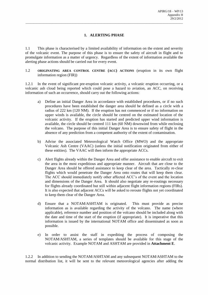
1. ALERTING PHASE
1.1 This phase is characterised by a limited availability of information on the extent and severity
of the volcanic event. The purpose of this phase is to ensure the safety of aircraft in flight and to
promulgate information as a matter of urgency. Regardless of the extent of information available the
alerting phase actions should be carried out for every event.
1.2 ORIGINATING AREA CONTROL CENTRE (ACC) ACTIONS (eruption in its own flight
information region (FIR))
1.2.1 In the event of significant pre-eruption volcanic activity, a volcanic eruption occurring, or a
volcanic ash cloud being reported which could pose a hazard to aviation, an ACC, on receiving
information of such an occurrence, should carry out the following actions:
a) Define an initial Danger Area in accordance with established procedures, or if no such
procedures have been established the danger area should be defined as a circle with a
radius of 222 km (120 NM). If the eruption has not commenced or if no information on
upper winds is available, the circle should be centred on the estimated location of the
volcanic activity. If the eruption has started and predicted upper wind information is
available, the circle should be centred 111 km (60 NM) downwind from while enclosing
the volcano. The purpose of this initial Danger Area is to ensure safety of flight in the
absence of any prediction from a competent authority of the extent of contamination.
b) Advise the associated Meteorological Watch Office (MWO) and the appropriate
Volcanic Ash Centre (VAAC) (unless the initial notification originated from either of
these entities). The VAAC will then inform the appropriate ACCs.
c) Alert flights already within the Danger Area and offer assistance to enable aircraft to exit
the area in the most expeditious and appropriate manner. Aircraft that are close to the
Danger Area should be offered assistance to keep clear of the area. Tactically re-clear
flights which would penetrate the Danger Area onto routes that will keep them clear.
The ACC should immediately notify other affected ACC’s of the event and the location
and dimensions of the Danger Area. It should also negotiate any re-routings necessary
for flights already coordinated but still within adjacent flight information regions (FIRs).
It is also expected that adjacent ACCs will be asked to reroute flights not yet coordinated
to keep them clear of the Danger Area.
d) Ensure that a NOTAM/ASHTAM is originated. This must provide as precise
information as is available regarding the activity of the volcano. The name (where
applicable), reference number and position of the volcano should be included along with
the date and time of the start of the eruption (if appropriate). It is imperative that this
information is issued by the international NOTAM office and disseminated as soon as
possible.
e) In order to assist the staff in expediting the process of composing the
NOTAM/ASHTAM, a series of templates should be available for this stage of the
volcanic activity. Example NOTAM and ASHTAM are provided in Attachment E.
1.2.2 In addition to sending the NOTAM/ASHTAM and any subsequent NOTAM/ASHTAM to the
normal distribution list, it will be sent to the relevant meteorological agencies after adding the
APIRG/18 – WP/13
Appendix H 29/2/2012
____________________________________________________________________________________________________
appropriate World Meteorological Organization (WMO) header. Example NOTAM and ASHTAM
are provided in Attachment E.
1.3 ADJACENT ACC ACTIONS
1.3.1 During the Alerting Phase aircraft should be tactically rerouted to avoid the Danger Area.
Any ash contamination should be contained within a limited area and disruption to traffic should not
be excessive. Adjacent ACCs should take the following action to assist:
a) When advised, re-clear flights to which services are being provided and which will be
affected by the Danger Area.
b) Unless otherwise instructed, continue normal operations except:
i) if one or more routes are affected by the Danger Area, stop clearing aircraft
on these routes and take steps to reroute onto routes clear of the Danger Area;
and
ii) initiate a running plot of the affected area.
2. REACTIVE PHASE
2.1 This phase commences at the outbreak of volcanic eruption. Major activities of the Reactive
Phase are: Issuance of an eruption commenced SIGMET, eruption commenced NOTAM/ASHTAM
and rerouting of airborne traffic. As appropriate, Danger Areas will be notified via NOTAM. This
phase will last until such time as the Proactive Phase can be activated.
2.2 ORIGINATING ACC ACTIONS (eruption in its own FIR)
2.2.1 The ACC providing services in the FIR within which the volcanic eruption takes place should
inform flights about the existence, extent and forecast movement of volcanic ash and provide
information useful for the safe conduct of flights.
2.2.2 Rerouting of traffic commences immediately or may be in progress if the alerting time has
been sufficient to facilitate activation of the Alerting Phase. The ACC should assist in rerouting
aircraft around the Danger Area as expeditiously as possible. Adjacent ACCs should also take the
Danger Area into account and give similar assistance to aircraft as early as possible.
2.2.3 During this phase the ACC should:
a) Maintain close liaison with its associated MWO. The MWO should issue a SIGMET
message on the extent and forecast movement of the ash cloud based on appropriate
sources of information.
b) Ensure a NOTAM is originated to define a Danger Area.
c) Ensure that reported differences between published information and observations (pilot
reports, airborne measurements, etc.) are forwarded as soon as possible to the appropriate
authorities.
APIRG/18 – WP/13
Appendix H 29/2/2012
____________________________________________________________________________________________________
d) Should significant reductions in intensity of volcanic activity take place during this phase
and the airspace no longer is contaminated by volcanic ash, a NOTAMC cancelling the
last active NOTAM shall be issued stating the cause for cancellation; new ASHTAM
should be promulgated to update the situation. Otherwise, begin planning for the
Proactive Phase in conjunction with the affected ACCs.
2.3 ADJACENT ACC ACTIONS
2.3.1 During the Reactive Phase the adjacent ACCs should take the following action:
a) Maintain close liaison with the originating ACC to design, implement and keep up to
date measures which will enable aircraft to remain clear of Danger Areas.
b) In the event that tactical measures are required, the adjacent ACC should, in cooperation
with the originating ACC, impose such measures. .
c) Maintain a running plot of the affected area.
d) Begin planning for the Proactive Phase in conjunction with the appropriate ACCs
concerned.
3. PROACTIVE PHASE
3.1 The Proactive Phase commences with the issuance of the first VAA/VAG by Toulouse
VAAC after completion of the reactive responses. The VAA/VAG will contain forecasts of the
expected vertical and horizontal extent of the volcanic ash cloud, and its expected movement, at six-
hourly time-steps for the period T+0 to T+18 hours. In addition, the meteorological office co-located
with the VAAC will issue ash concentration forecasts to supplement the VAA/VAG information, at
six-hourly intervals with a nominal validity time of 0000Z, 0600Z, 1200Z and 1800Z which will
define Areas of Low, Medium and High Contamination.
3.2 Following the Reactive Phase, the VAA/VAG and (where available) ash concentration
forecasts should be used to define airspace volumes encompassing the furthest extent of
contamination predicted for that period. These volumes should be used to:
a) publish NOTAM indicating the extent of Danger Areas, indicating which areas of
contamination are included therein;
b) issue SIGMET warning of potential hazard from areas of volcanic ash contamination;
c) publish NOTAM to separately indicate the extent of Areas of Medium Contamination if
not included in a Danger Area.
3.3 Longer term forecasts (i.e. beyond T+6 hours) should be used to generate NOTAM in order to
ensure that adequate information is available to support flight planning. These messages should
differentiate between levels of contamination.
3.4 Operators should use the information published regarding Areas of Low, Medium and High
Contamination to plan their flights in accordance with their regulatory requirements and the service
APIRG/18 – WP/13
Appendix H 29/2/2012
____________________________________________________________________________________________________
that will be provided in the airspace concerned. Operators should be aware that, depending on the
State concerned, Danger Areas may be established to contain an Area of High Contamination, Areas
of Medium/High Contamination, or Areas of Low/Medium/High Contamination.
3.5 The volcanic ash may affect any combination of airspace; therefore, it is impossible to
prescribe measures to be taken for any particular situation. Nor is it possible to detail the actions to be
taken by any particular ACC. The following guidance may prove useful during the Proactive Phase
but should not be considered mandatory:
a) ACCs affected by the movement of the ash should continue to originate
NOTAM/ASHTAM at appropriate intervals. ACCs concerned should continue to
publish details on measures taken.
b) Depending on the impact of the volcanic ash, the appropriate ACC may take the
initiative to organise teleconferences to exchange latest information on the
developments with Toulouse VAAC, ANSPs and MWO’s and operators concerned.
c) During this phase the VAAC should endeavour to assess the vertical extent of the ash
contamination and provide appropriate VAA/VAG to define the contaminated airspace
as accurately as possible. For the purpose of flight planning, operators should treat the
horizontal and vertical limits of the Danger Area to be over-flown as they would
mountainous terrain. Operators are cautioned regarding the risk of cabin
depressurisation or engine failure resulting in the inability to maintain level flight above
the Danger Area, especially where Extended Twin Operations (ETOPS) aircraft are
involved.
d) Any reported differences between published information and observations (pilot
reports, airborne measurements, etc.) should be forwarded as soon as possible to the
appropriate authorities; and
e) When the airspace is no longer contaminated by volcanic ash, a NOTAMC cancelling
the active NOTAM shall be promulgated. New ASHTAM should be promulgated to
update the situation.
4. AIR TRAFFIC CONTROL PROCEDURES5
4.1 If volcanic ash is reported or forecast in the FIR for which the ACC is responsible, the
following procedures should be followed:
a) relay all available information immediately to pilots whose aircraft could be affected to
ensure that they are aware of the horizontal and vertical extent of the ash contamination;
b) if requested, suggest appropriate rerouting to assist flights to avoid areas of known or
forecast ash contamination;
c) When appropriate, remind pilots that volcanic ash may not be detected by ATC radar
systems;
5 This information is adapted from the Manual on Volcanic Ash, Radioactive Material and Toxic Chemical
Clouds (Doc 9691). Refer to this document for full details.
APIRG/18 – WP/13
Appendix H 29/2/2012
____________________________________________________________________________________________________
d) If modelled ash concentration charts are available showing Areas of Low, Medium and
High Contamination, the Provider State may establish Danger Areas. Depending on the
State concerned, the Danger Areas will be established to contain an Area of High
Contamination, Areas of Medium/High Contamination, or Areas of Low/Medium/High
Contamination;
e) In the absence of ash concentration guidance, the entire area of forecast volcanic ash
should be considered as an Area of High Contamination, for the purposes of applying
ATC procedures, until ash concentration guidance is available;
f) Normally, ATC should not provide a clearance for an aircraft to enter or operate within a
Danger Area. Assistance to enable an aircraft to exit a Danger Area in the most
expeditious and appropriate manner should be provided;
g) If the ACC has been advised by an aircraft that it has entered an area of ash
contamination and indicates that a distress situation exists:
i) consider the aircraft to be in an emergency situation;
ii) do not initiate any climb clearances to turbine-powered aircraft until the
aircraft has exited the area of ash contamination; and
iii) do not attempt to provide vectors without pilot concurrence.
4.2 Experience has shown that the recommended escape manoeuvre for an aircraft which has
encountered volcanic ash is to reverse its course and begin a descent (if terrain permits). However, the
final responsibility for this decision rests with the pilot.
5. GENERAL GUIDANCE FOR THE DEVELOPMENT OF ATS CONTINGENCY PLANS
FOR VOLCANIC ASH6
5.1 In a contingency plan relating to volcanic ash certain steps need to be taken to provide a
coordinated and controlled response for dealing with an event of this nature. Responsibilities should
be clearly defined for the manager in charge, supervisors and Air Traffic Controllers (ATCOs). The
plan should also identify the officials who need to be contacted, the type of messages that are to be
created, the proper distribution of the messages and how to conduct business.
5.2 ATCOs need to be trained and be made aware of the potential effects if aircraft encounter
unsafe levels of volcanic ash.
5.3 Some particular points of guidance are as follows:
a) Volcanic ash clouds may extend for hundreds of miles horizontally and reach the
stratosphere vertically;
b) Volcanic ash may block the pitot-static system of an aircraft, resulting in unreliable
airspeed indications;
c) Braking conditions at airports where volcanic ash has recently been deposited on the
runway will affect the braking ability of the aircraft. This is more pronounced on
runways contaminated with wet ash. Pilots and ATCOs should be aware of the
consequences of volcanic ash being ingested into the engines during landing and taxiing.
6 This information is adapted from the Manual on Volcanic Ash, Radioactive Material and Toxic Chemical
Clouds (Doc 9691). Refer to this document for full details.
APIRG/18 – WP/13
Appendix H 29/2/2012
____________________________________________________________________________________________________
For departure it is recommended that pilots avoid operating in visible airborne ash;
instead they should allow sufficient time for the particles to settle before initiating a take-
off roll, in order to avoid ingestion of ash particles into the engine. In addition, the
movement area to be used should be carefully swept before any engine is started;
d) Volcanic ash may result in the failure or power loss of one or all engines of an aeroplane;
and
e) Airports might have to be declared unsafe for flight operations. This might have
consequences for the ATM system.
5.4 The ACC serves as the critical communication link between the pilot, dispatcher and
meteorologists during a volcanic eruption. During episodes of volcanic ash contamination within the
FIR, the ACC has two major communication roles. First and of greatest importance is its ability to
communicate directly with aircraft en route which may encounter the ash. Based on the information
provided in the volcanic ash SIGMET and VAAs and working with MWO, the ATCOs should be able
to advise the pilot of which flight levels are affected by the ash and the projected trajectory and drift
of the contamination. Through the use of radio communication, ACCs have the capability to
coordinate with the pilot alternative routes which would keep the aircraft away from the volcanic ash.
5.5 Similarly, through the origination of a NOTAM/ASHTAM for volcanic activity the ACC
can disseminate information on the status and activity of a volcano even for pre-eruption increases in
volcanic activity. NOTAM/ASHTAM and SIGMET together with special AIREPs are critical to
dispatchers for flight planning purposes. Operators need as much advance notification as possible on
the status of a volcano for strategic planning of flights and the safety of the flying public. Dispatchers
need to be in communication with pilots en route so that a coordinated decision can be made between
the pilot, the dispatcher and ATC regarding alternative routes that are available. It cannot be
presumed, however, that an aircraft which is projected to encounter ash will be provided with the
most desirable route to avoid the contamination. Other considerations have to be taken into account
such as existing traffic levels on other routes and the amount of fuel reserve available for flights
which may have to be diverted to other routes to allow for the affected aircraft to divert.
5.6 The NOTAM/ASHTAM for volcanic activity provide information on the status of activity of
a volcano when a change in its activity is, or is expected to be, of operational significance. They are
originated by the ACC and issued through the respective international NOTAM office based on the
information received from any one of the observing sources and/or advisory information provided by
the Toulouse VAAC. In addition to providing the status of activity of a volcano, the
NOTAM/ASHTAM also provides information on the location, extent and movement of the ash
contamination and the air routes and flight levels affected. NOTAM can also be used to limit access
to the airspace affected by the volcanic ash. Complete guidance on the issuance of NOTAM and
ASHTAM is provided in Annex 15 — Aeronautical Information Services. Included in Annex 15 is a
volcano level of activity colour code chart. The colour code chart alert may be used to provide
information on the status of the volcano, with “red” being the most severe, i.e. volcanic eruption in
progress with an ash column/cloud reported above flight level 250, and “green” at the other extreme
being volcanic activity considered to have ceased and volcano reverted to its normal pre-eruption
state. It is very important that NOTAM for volcanic ash be cancelled and ASHTAM be updated as
soon as the volcano has reverted to its normal pre-eruption status, no further eruptions are expected by
volcanologists and no ash is detectable or reported from the FIR concerned.
5.7 It is essential that the procedures which the ACC personnel, including supporting services
such as MET and AIS should follow during a volcanic eruption/ash cloud event described in the
foregoing paragraphs are translated into the local staff instructions (adjusted as necessary to take
account of local circumstances). It is also essential that these procedures/instructions form part of the
basic training for all MET, ATS and AIS personnel whose jobs would require them to take action in

APIRG/18 – WP/13
Appendix H 29/2/2012
____________________________________________________________________________________________________
accordance with the procedures. Background information to assist the ACC or Flight Information
Centre (FIC) in maintaining an awareness of the status of activity of volcanoes in their FIR(s) is
provided in the ICAO monthly International Airways Volcano Watch (IAVW) website at:
http://www2.icao.int/en/anb/met-aim/met/iavwopsg/Pages/default.aspx under Worldwide Weekly
Volcanic Activity Reports webpage. The major AFI volcanoes are listed in Attachment F.
APIRG/18 – WP/13
Appendix H 29/2/2012
____________________________________________________________________________________________________
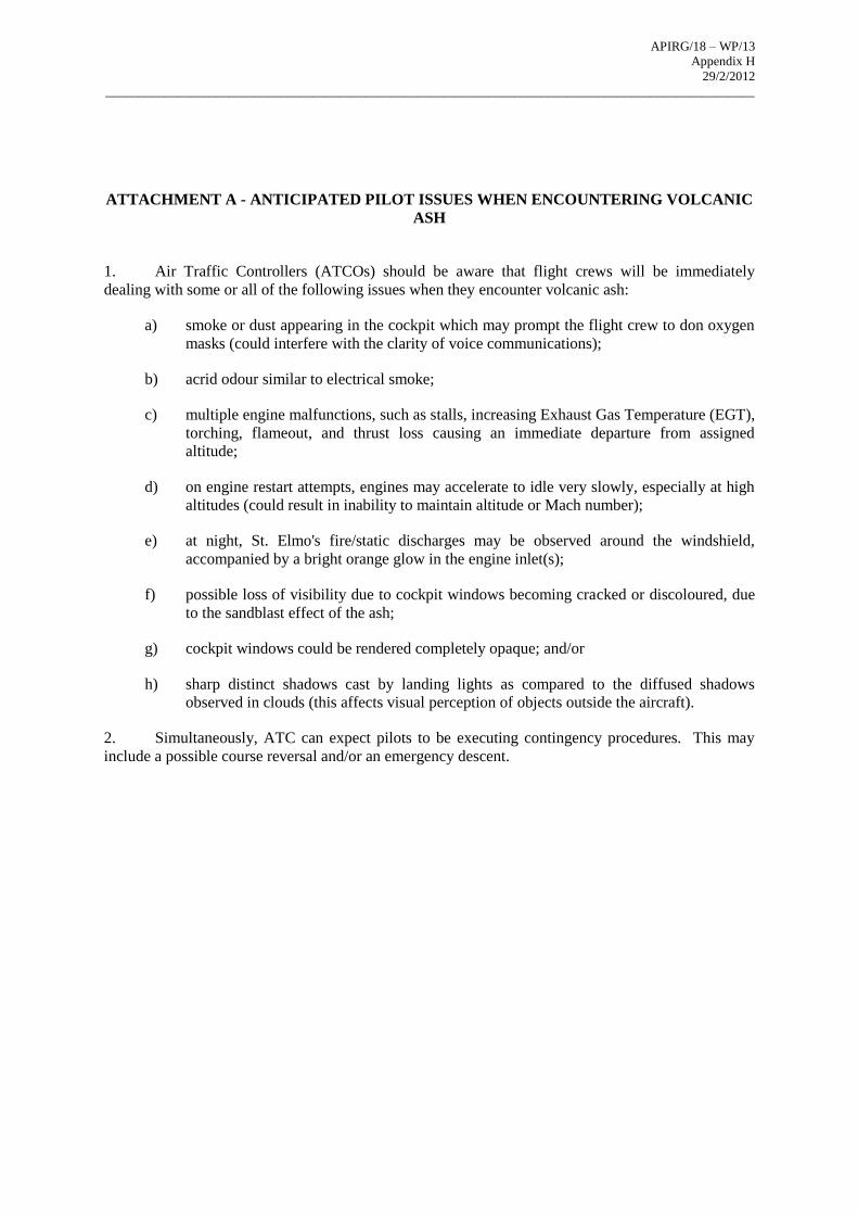
ATTACHMENT A - ANTICIPATED PILOT ISSUES WHEN ENCOUNTERING VOLCANIC
ASH
1. Air Traffic Controllers (ATCOs) should be aware that flight crews will be immediately
dealing with some or all of the following issues when they encounter volcanic ash:
a) smoke or dust appearing in the cockpit which may prompt the flight crew to don oxygen
masks (could interfere with the clarity of voice communications);
b) acrid odour similar to electrical smoke;
c) multiple engine malfunctions, such as stalls, increasing Exhaust Gas Temperature (EGT),
torching, flameout, and thrust loss causing an immediate departure from assigned
altitude;
d) on engine restart attempts, engines may accelerate to idle very slowly, especially at high
altitudes (could result in inability to maintain altitude or Mach number);
e) at night, St. Elmo's fire/static discharges may be observed around the windshield,
accompanied by a bright orange glow in the engine inlet(s);
f) possible loss of visibility due to cockpit windows becoming cracked or discoloured, due
to the sandblast effect of the ash;
g) cockpit windows could be rendered completely opaque; and/or
h) sharp distinct shadows cast by landing lights as compared to the diffused shadows
observed in clouds (this affects visual perception of objects outside the aircraft).
2. Simultaneously, ATC can expect pilots to be executing contingency procedures. This may
include a possible course reversal and/or an emergency descent.

APIRG/18 – WP/13
Appendix H 29/2/2012
____________________________________________________________________________________________________
APIRG/18 – WP/13
Appendix H 29/2/2012
____________________________________________________________________________________________________
ATTACHMENT B - ACTION TAKEN BY METEOROLOGICAL WATCH OFFICES
(MWO)
IN THE EVENT OF A VOLCANIC ERUPTION7
1. On receipt of information of a volcanic eruption and/or the existence of volcanic ash, the
MWO will:
a) Notify, if necessary, the AFI VAAC (Toulouse) designated to provide VAA/VAG for the
FIR for which the MWO is responsible that a volcanic eruption and/or ash has been
reported. In the event that the MWO becomes aware, from a source other than an ACC,
of the occurrence of pre-eruption activity, a volcanic eruption or ash from any other
source , the information will be passed with all available relevant details on the extent,
forecast movement and concentration of volcanic ash immediately to the ACC and to the
designated VAAC;
b) Reported differences between ash encounters by aircraft and the information published in
VAA/VAG, SIGMET or NOTAM/ASHTAM received by an ACC shall be made
available as soon as possible to the respective MWO, preferably in the form of an
AIREP. The MWO will relay the information to the respective originators of the
published information;
c) Notify adjacent MWOs designated to provide SIGMET that a volcanic eruption and/or
ash cloud has been reported, provide available relevant details on the extent, forecast
movement and (if known) concentration of volcanic ash. In the event that any other
MWO becomes aware of the occurrence of volcanic ash cloud from any source other
than the VAAC, the information should be passed immediately to the VAAC and any
adjacent MWO(s) downstream of the moving ash cloud;
d) As soon as practicable, advise the ACC and the VAAC whether or not the volcanic ash is
identifiable from satellite images/data, ground based or airborne measurements or other
relevant sources;
e) Issue SIGMET relating to the horizontal and vertical extent of volcanic ash cloud and its
expected movement (provided in the VA from Toulouse VAAC) for a validity period of
up to 6 hours. The SIGMET shall include an observed (or forecast) position of the ash
cloud at the start of the period of validity, and a forecast position at the end of the period
of validity. The SIGMET should be based on the advisory information provided by the
VAAC. Include in the SIGMET distribution list the two Regional OPMET Databanks
(RODBs) in Dakar and Johannesburg (Pretoria RODB). As well as inter-regional
distribution, the RODBs will ensure dissemination of the SIGMET to all the VAAC, the
London World Area Forecast Centre (WAFC) and the AFI Bulletin Compiling Centres
(BCC);
f) provide information to assist with the origination of NOTAM by ACCs and maintain
continuous coordination with ACCs, adjacent MWOs and the VAAC concerned to
ensure consistency in the issuance and content of SIGMET and NOTAM/ASHTAM; and
g) provide, if possible, regular volcanic briefings, based on the latest available ash
observations and forecasts, to ACCs, Airport Operators and aircraft operators concerned,
giving an outlook for beyond T+12 hours.
7 This information is adapted from the Handbook on the International Airways Volcano Watch (IAVW) (Doc
9766). Refer to this document for full details.
APIRG/18 – WP/13
Appendix H 29/2/2012
____________________________________________________________________________________________________
ATTACHMENT C - ACTION TO BE TAKEN BY THE AFI VAAC IN THE EVENT OF A
VOLCANIC ERUPTION8
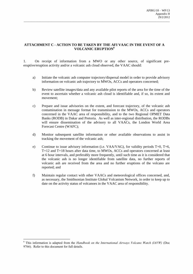
1. On receipt of information from a MWO or any other source, of significant pre-
eruptive/eruption activity and/or a volcanic ash cloud observed, the VAAC should:
a) Initiate the volcanic ash computer trajectory/dispersal model in order to provide advisory
information on volcanic ash trajectory to MWOs, ACCs and operators concerned;
b) Review satellite images/data and any available pilot reports of the area for the time of the
event to ascertain whether a volcanic ash cloud is identifiable and, if so, its extent and
movement;
c) Prepare and issue advisories on the extent, and forecast trajectory, of the volcanic ash
contamination in message format for transmission to the MWOs, ACCs and operators
concerned in the VAAC area of responsibility, and to the two Regional OPMET Data
Banks (RODB) in Dakar and Pretoria. As well as inter-regional distribution, the RODBs
will ensure dissemination of the advisory to all VAACs, the London World Area
Forecast Centre (WAFC);
d) Monitor subsequent satellite information or other available observations to assist in
tracking the movement of the volcanic ash;
e) Continue to issue advisory information (i.e. VAA/VAG), for validity periods T+0, T+6,
T+12 and T+18 hours after data time, to MWOs, ACCs and operators concerned at least
at 6 hour intervals, and preferably more frequently, until such time as it is considered that
the volcanic ash is no longer identifiable from satellite data, no further reports of
volcanic ash are received from the area and no further eruptions of the volcano are
reported; and
f) Maintain regular contact with other VAACs and meteorological offices concerned, and,
as necessary, the Smithsonian Institute Global Volcanism Network, in order to keep up to
date on the activity status of volcanoes in the VAAC area of responsibility.
8 This information is adapted from the Handbook on the International Airways Volcano Watch (IAVW) (Doc
9766). Refer to this document for full details.
APIRG/18 – WP/13
Appendix H 29/2/2012
____________________________________________________________________________________________________
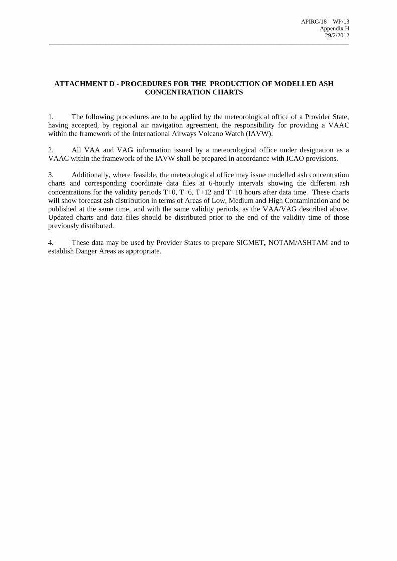
ATTACHMENT D - PROCEDURES FOR THE PRODUCTION OF MODELLED ASH
CONCENTRATION CHARTS
1. The following procedures are to be applied by the meteorological office of a Provider State,
having accepted, by regional air navigation agreement, the responsibility for providing a VAAC
within the framework of the International Airways Volcano Watch (IAVW).
2. All VAA and VAG information issued by a meteorological office under designation as a
VAAC within the framework of the IAVW shall be prepared in accordance with ICAO provisions.
3. Additionally, where feasible, the meteorological office may issue modelled ash concentration
charts and corresponding coordinate data files at 6-hourly intervals showing the different ash
concentrations for the validity periods T+0, T+6, T+12 and T+18 hours after data time. These charts
will show forecast ash distribution in terms of Areas of Low, Medium and High Contamination and be
published at the same time, and with the same validity periods, as the VAA/VAG described above.
Updated charts and data files should be distributed prior to the end of the validity time of those
previously distributed.
4. These data may be used by Provider States to prepare SIGMET, NOTAM/ASHTAM and to
establish Danger Areas as appropriate.
APIRG/18 – WP/13
Appendix H 29/2/2012
____________________________________________________________________________________________________
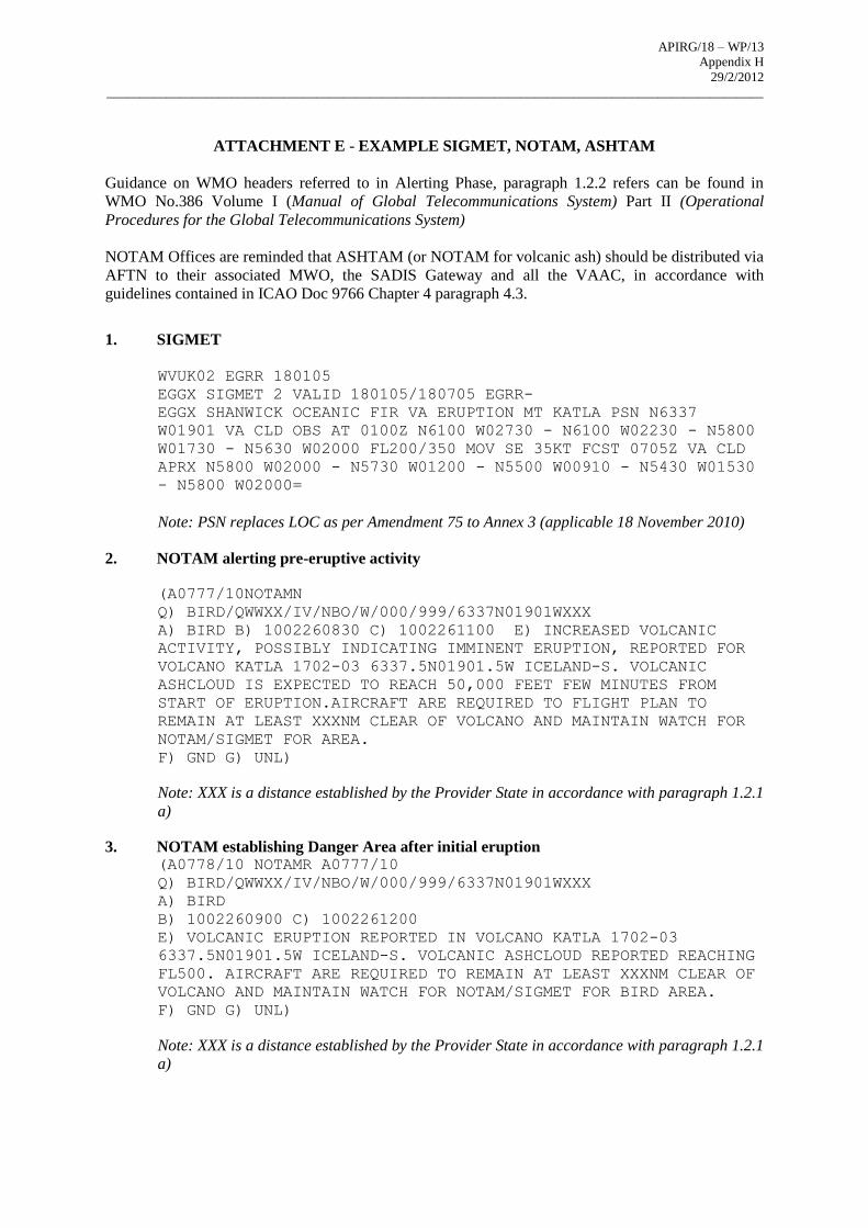
ATTACHMENT E - EXAMPLE SIGMET, NOTAM, ASHTAM
Guidance on WMO headers referred to in Alerting Phase, paragraph 1.2.2 refers can be found in
WMO No.386 Volume I (Manual of Global Telecommunications System) Part II (Operational
Procedures for the Global Telecommunications System)
NOTAM Offices are reminded that ASHTAM (or NOTAM for volcanic ash) should be distributed via
AFTN to their associated MWO, the SADIS Gateway and all the VAAC, in accordance with
guidelines contained in ICAO Doc 9766 Chapter 4 paragraph 4.3.
1. SIGMET
WVUK02 EGRR 180105
EGGX SIGMET 2 VALID 180105/180705 EGRR-
EGGX SHANWICK OCEANIC FIR VA ERUPTION MT KATLA PSN N6337
W01901 VA CLD OBS AT 0100Z N6100 W02730 - N6100 W02230 - N5800
W01730 - N5630 W02000 FL200/350 MOV SE 35KT FCST 0705Z VA CLD
APRX N5800 W02000 - N5730 W01200 - N5500 W00910 - N5430 W01530
- N5800 W02000=
Note: PSN replaces LOC as per Amendment 75 to Annex 3 (applicable 18 November 2010)
2. NOTAM alerting pre-eruptive activity
(A0777/10NOTAMN
Q) BIRD/QWWXX/IV/NBO/W/000/999/6337N01901WXXX
A) BIRD B) 1002260830 C) 1002261100 E) INCREASED VOLCANIC
ACTIVITY, POSSIBLY INDICATING IMMINENT ERUPTION, REPORTED FOR
VOLCANO KATLA 1702-03 6337.5N01901.5W ICELAND-S. VOLCANIC
ASHCLOUD IS EXPECTED TO REACH 50,000 FEET FEW MINUTES FROM
START OF ERUPTION.AIRCRAFT ARE REQUIRED TO FLIGHT PLAN TO
REMAIN AT LEAST XXXNM CLEAR OF VOLCANO AND MAINTAIN WATCH FOR
NOTAM/SIGMET FOR AREA.
F) GND G) UNL)
Note: XXX is a distance established by the Provider State in accordance with paragraph 1.2.1
a)
3. NOTAM establishing Danger Area after initial eruption (A0778/10 NOTAMR A0777/10
Q) BIRD/QWWXX/IV/NBO/W/000/999/6337N01901WXXX
A) BIRD
B) 1002260900 C) 1002261200
E) VOLCANIC ERUPTION REPORTED IN VOLCANO KATLA 1702-03
6337.5N01901.5W ICELAND-S. VOLCANIC ASHCLOUD REPORTED REACHING
FL500. AIRCRAFT ARE REQUIRED TO REMAIN AT LEAST XXXNM CLEAR OF
VOLCANO AND MAINTAIN WATCH FOR NOTAM/SIGMET FOR BIRD AREA.
F) GND G) UNL)
Note: XXX is a distance established by the Provider State in accordance with paragraph 1.2.1
a)
APIRG/18 – WP/13
Appendix H 29/2/2012
____________________________________________________________________________________________________
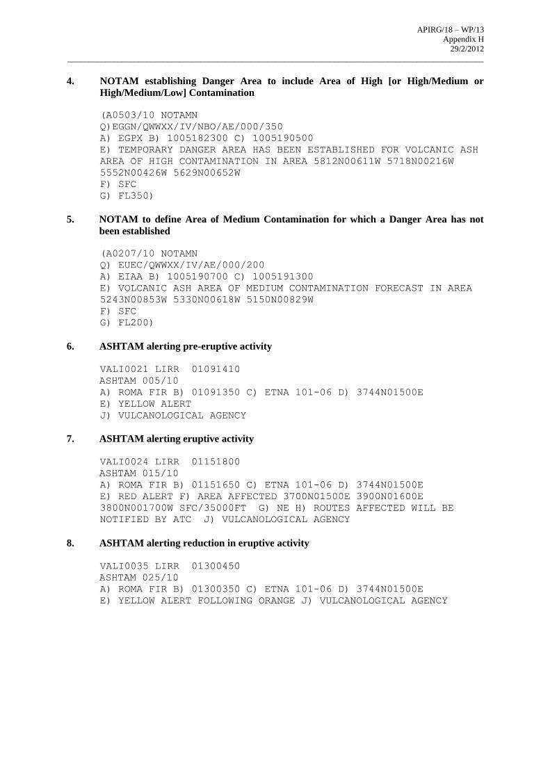
4. NOTAM establishing Danger Area to include Area of High [or High/Medium or
High/Medium/Low] Contamination
(A0503/10 NOTAMN
Q)EGGN/QWWXX/IV/NBO/AE/000/350
A) EGPX B) 1005182300 C) 1005190500
E) TEMPORARY DANGER AREA HAS BEEN ESTABLISHED FOR VOLCANIC ASH
AREA OF HIGH CONTAMINATION IN AREA 5812N00611W 5718N00216W
5552N00426W 5629N00652W
F) SFC
G) FL350)
5. NOTAM to define Area of Medium Contamination for which a Danger Area has not
been established
(A0207/10 NOTAMN
Q) EUEC/QWWXX/IV/AE/000/200
A) EIAA B) 1005190700 C) 1005191300
E) VOLCANIC ASH AREA OF MEDIUM CONTAMINATION FORECAST IN AREA
5243N00853W 5330N00618W 5150N00829W
F) SFC
G) FL200)
6. ASHTAM alerting pre-eruptive activity
VALI0021 LIRR 01091410
ASHTAM 005/10
A) ROMA FIR B) 01091350 C) ETNA 101-06 D) 3744N01500E
E) YELLOW ALERT
J) VULCANOLOGICAL AGENCY
7. ASHTAM alerting eruptive activity
VALI0024 LIRR 01151800
ASHTAM 015/10
A) ROMA FIR B) 01151650 C) ETNA 101-06 D) 3744N01500E
E) RED ALERT F) AREA AFFECTED 3700N01500E 3900N01600E
3800N001700W SFC/35000FT G) NE H) ROUTES AFFECTED WILL BE
NOTIFIED BY ATC J) VULCANOLOGICAL AGENCY
8. ASHTAM alerting reduction in eruptive activity
VALI0035 LIRR 01300450
ASHTAM 025/10
A) ROMA FIR B) 01300350 C) ETNA 101-06 D) 3744N01500E
E) YELLOW ALERT FOLLOWING ORANGE J) VULCANOLOGICAL AGENCY

APIRG/18 – WP/13
Appendix H 29/2/2012
____________________________________________________________________________________________________
APIRG/18 – WP/13
Appendix H 29/2/2012
____________________________________________________________________________________________________
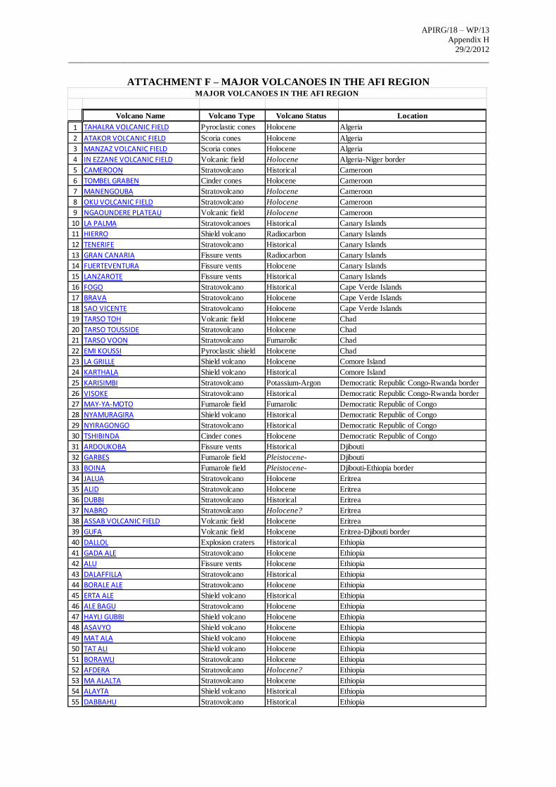
ATTACHMENT F – MAJOR VOLCANOES IN THE AFI REGION
Volcano Name Volcano Type Volcano Status Location
1 TAHALRA VOLCANIC FIELD Pyroclastic cones Holocene Algeria
2 ATAKOR VOLCANIC FIELD Scoria cones Holocene Algeria
3 MANZAZ VOLCANIC FIELD Scoria cones Holocene Algeria
4 IN EZZANE VOLCANIC FIELD Volcanic field Holocene Algeria-Niger border
5 CAMEROON Stratovolcano Historical Cameroon
6 TOMBEL GRABEN Cinder cones Holocene Cameroon
7 MANENGOUBA Stratovolcano Holocene Cameroon
8 OKU VOLCANIC FIELD Stratovolcano Holocene Cameroon
9 NGAOUNDERE PLATEAU Volcanic field Holocene Cameroon
10 LA PALMA Stratovolcanoes Historical Canary Islands
11 HIERRO Shield volcano Radiocarbon Canary Islands
12 TENERIFE Stratovolcano Historical Canary Islands
13 GRAN CANARIA Fissure vents Radiocarbon Canary Islands
14 FUERTEVENTURA Fissure vents Holocene Canary Islands
15 LANZAROTE Fissure vents Historical Canary Islands
16 FOGO Stratovolcano Historical Cape Verde Islands
17 BRAVA Stratovolcano Holocene Cape Verde Islands
18 SAO VICENTE Stratovolcano Holocene Cape Verde Islands
19 TARSO TOH Volcanic field Holocene Chad
20 TARSO TOUSSIDE Stratovolcano Holocene Chad
21 TARSO VOON Stratovolcano Fumarolic Chad
22 EMI KOUSSI Pyroclastic shield Holocene Chad
23 LA GRILLE Shield volcano Holocene Comore Island
24 KARTHALA Shield volcano Historical Comore Island
25 KARISIMBI Stratovolcano Potassium-Argon Democratic Republic Congo-Rwanda border
26 VISOKE Stratovolcano Historical Democratic Republic Congo-Rwanda border
27 MAY-YA-MOTO Fumarole field Fumarolic Democratic Republic of Congo
28 NYAMURAGIRA Shield volcano Historical Democratic Republic of Congo
29 NYIRAGONGO Stratovolcano Historical Democratic Republic of Congo
30 TSHIBINDA Cinder cones Holocene Democratic Republic of Congo
31 ARDOUKOBA Fissure vents Historical Djibouti
32 GARBES Fumarole field Pleistocene- Djibouti
33 BOINA Fumarole field Pleistocene- Djibouti-Ethiopia border
34 JALUA Stratovolcano Holocene Eritrea
35 ALID Stratovolcano Holocene Eritrea
36 DUBBI Stratovolcano Historical Eritrea
37 NABRO Stratovolcano Holocene? Eritrea
38 ASSAB VOLCANIC FIELD Volcanic field Holocene Eritrea
39 GUFA Volcanic field Holocene Eritrea-Djibouti border
40 DALLOL Explosion craters Historical Ethiopia
41 GADA ALE Stratovolcano Holocene Ethiopia
42 ALU Fissure vents Holocene Ethiopia
43 DALAFFILLA Stratovolcano Historical Ethiopia
44 BORALE ALE Stratovolcano Holocene Ethiopia
45 ERTA ALE Shield volcano Historical Ethiopia
46 ALE BAGU Stratovolcano Holocene Ethiopia
47 HAYLI GUBBI Shield volcano Holocene Ethiopia
48 ASAVYO Shield volcano Holocene Ethiopia
49 MAT ALA Shield volcano Holocene Ethiopia
50 TAT ALI Shield volcano Holocene Ethiopia
51 BORAWLI Stratovolcano Holocene Ethiopia
52 AFDERA Stratovolcano Holocene? Ethiopia
53 MA ALALTA Stratovolcano Holocene Ethiopia
54 ALAYTA Shield volcano Historical Ethiopia
55 DABBAHU Stratovolcano Historical Ethiopia
MAJOR VOLCANOES IN THE AFI REGION

APIRG/18 – WP/13
Appendix H 29/2/2012
____________________________________________________________________________________________________
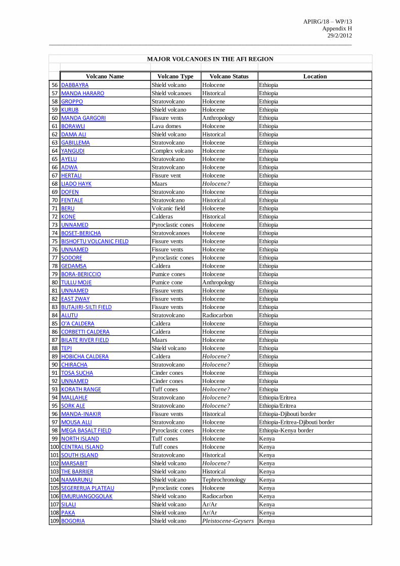
APIRG/18 – WP/13
Appendix H 29/2/2012
____________________________________________________________________________________________________
Volcano Name Volcano Type Volcano Status Location
56 DABBAYRA Shield volcano Holocene Ethiopia
57 MANDA HARARO Shield volcanoes Historical Ethiopia
58 GROPPO Stratovolcano Holocene Ethiopia
59 KURUB Shield volcano Holocene Ethiopia
60 MANDA GARGORI Fissure vents Anthropology Ethiopia
61 BORAWLI Lava domes Holocene Ethiopia
62 DAMA ALI Shield volcano Historical Ethiopia
63 GABILLEMA Stratovolcano Holocene Ethiopia
64 YANGUDI Complex volcano Holocene Ethiopia
65 AYELU Stratovolcano Holocene Ethiopia
66 ADWA Stratovolcano Holocene Ethiopia
67 HERTALI Fissure vent Holocene Ethiopia
68 LIADO HAYK Maars Holocene? Ethiopia
69 DOFEN Stratovolcano Holocene Ethiopia
70 FENTALE Stratovolcano Historical Ethiopia
71 BERU Volcanic field Holocene Ethiopia
72 KONE Calderas Historical Ethiopia
73 UNNAMED Pyroclastic cones Holocene Ethiopia
74 BOSET-BERICHA Stratovolcanoes Holocene Ethiopia
75 BISHOFTU VOLCANIC FIELD Fissure vents Holocene Ethiopia
76 UNNAMED Fissure vents Holocene Ethiopia
77 SODORE Pyroclastic cones Holocene Ethiopia
78 GEDAMSA Caldera Holocene Ethiopia
79 BORA-BERICCIO Pumice cones Holocene Ethiopia
80 TULLU MOJE Pumice cone Anthropology Ethiopia
81 UNNAMED Fissure vents Holocene Ethiopia
82 EAST ZWAY Fissure vents Holocene Ethiopia
83 BUTAJIRI-SILTI FIELD Fissure vents Holocene Ethiopia
84 ALUTU Stratovolcano Radiocarbon Ethiopia
85 O'A CALDERA Caldera Holocene Ethiopia
86 CORBETTI CALDERA Caldera Holocene Ethiopia
87 BILATE RIVER FIELD Maars Holocene Ethiopia
88 TEPI Shield volcano Holocene Ethiopia
89 HOBICHA CALDERA Caldera Holocene? Ethiopia
90 CHIRACHA Stratovolcano Holocene? Ethiopia
91 TOSA SUCHA Cinder cones Holocene Ethiopia
92 UNNAMED Cinder cones Holocene Ethiopia
93 KORATH RANGE Tuff cones Holocene? Ethiopia
94 MALLAHLE Stratovolcano Holocene? Ethiopia/Eritrea
95 SORK ALE Stratovolcano Holocene? Ethiopia/Eritrea
96 MANDA-INAKIR Fissure vents Historical Ethiopia-Djibouti border
97 MOUSA ALLI Stratovolcano Holocene Ethiopia-Eritrea-Djibouti border
98 MEGA BASALT FIELD Pyroclastic cones Holocene Ethiopia-Kenya border
99 NORTH ISLAND Tuff cones Holocene Kenya
100 CENTRAL ISLAND Tuff cones Holocene Kenya
101 SOUTH ISLAND Stratovolcano Historical Kenya
102 MARSABIT Shield volcano Holocene? Kenya
103 THE BARRIER Shield volcano Historical Kenya
104 NAMARUNU Shield volcano Tephrochronology Kenya
105 SEGERERUA PLATEAU Pyroclastic cones Holocene Kenya
106 EMURUANGOGOLAK Shield volcano Radiocarbon Kenya
107 SILALI Shield volcano Ar/Ar Kenya
108 PAKA Shield volcano Ar/Ar Kenya
109 BOGORIA Shield volcano Pleistocene-Geysers Kenya
MAJOR VOLCANOES IN THE AFI REGION
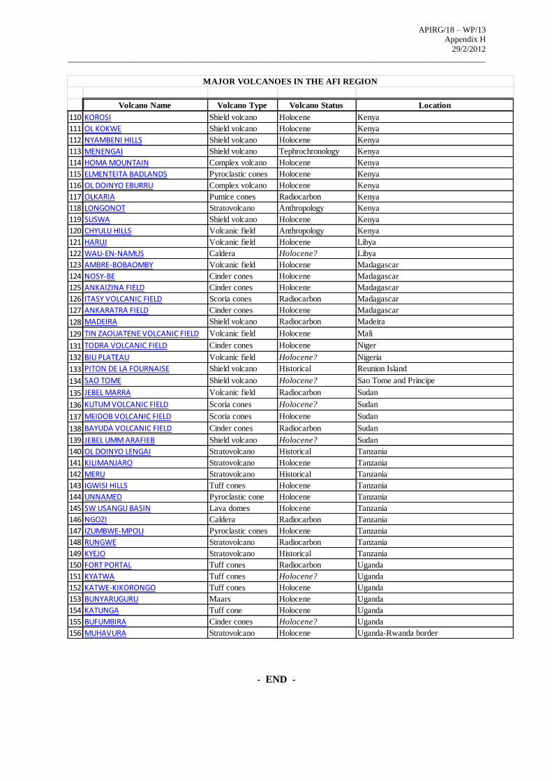
APIRG/18 – WP/13
Appendix H 29/2/2012
____________________________________________________________________________________________________
Volcano Name Volcano Type Volcano Status Location
110 KOROSI Shield volcano Holocene Kenya
111 OL KOKWE Shield volcano Holocene Kenya
112 NYAMBENI HILLS Shield volcano Holocene Kenya
113 MENENGAI Shield volcano Tephrochronology Kenya
114 HOMA MOUNTAIN Complex volcano Holocene Kenya
115 ELMENTEITA BADLANDS Pyroclastic cones Holocene Kenya
116 OL DOINYO EBURRU Complex volcano Holocene Kenya
117 OLKARIA Pumice cones Radiocarbon Kenya
118 LONGONOT Stratovolcano Anthropology Kenya
119 SUSWA Shield volcano Holocene Kenya
120 CHYULU HILLS Volcanic field Anthropology Kenya
121 HARUJ Volcanic field Holocene Libya
122 WAU-EN-NAMUS Caldera Holocene? Libya
123 AMBRE-BOBAOMBY Volcanic field Holocene Madagascar
124 NOSY-BE Cinder cones Holocene Madagascar
125 ANKAIZINA FIELD Cinder cones Holocene Madagascar
126 ITASY VOLCANIC FIELD Scoria cones Radiocarbon Madagascar
127 ANKARATRA FIELD Cinder cones Holocene Madagascar
128 MADEIRA Shield volcano Radiocarbon Madeira
129 TIN ZAOUATENE VOLCANIC FIELD Volcanic field Holocene Mali
131 TODRA VOLCANIC FIELD Cinder cones Holocene Niger
132 BIU PLATEAU Volcanic field Holocene? Nigeria
133 PITON DE LA FOURNAISE Shield volcano Historical Reunion Island
134 SAO TOME Shield volcano Holocene? Sao Tome and Principe
135 JEBEL MARRA Volcanic field Radiocarbon Sudan
136 KUTUM VOLCANIC FIELD Scoria cones Holocene? Sudan
137 MEIDOB VOLCANIC FIELD Scoria cones Holocene Sudan
138 BAYUDA VOLCANIC FIELD Cinder cones Radiocarbon Sudan
139 JEBEL UMM ARAFIEB Shield volcano Holocene? Sudan
140 OL DOINYO LENGAI Stratovolcano Historical Tanzania
141 KILIMANJARO Stratovolcano Holocene Tanzania
142 MERU Stratovolcano Historical Tanzania
143 IGWISI HILLS Tuff cones Holocene Tanzania
144 UNNAMED Pyroclastic cone Holocene Tanzania
145 SW USANGU BASIN Lava domes Holocene Tanzania
146 NGOZI Caldera Radiocarbon Tanzania
147 IZUMBWE-MPOLI Pyroclastic cones Holocene Tanzania
148 RUNGWE Stratovolcano Radiocarbon Tanzania
149 KYEJO Stratovolcano Historical Tanzania
150 FORT PORTAL Tuff cones Radiocarbon Uganda
151 KYATWA Tuff cones Holocene? Uganda
152 KATWE-KIKORONGO Tuff cones Holocene Uganda
153 BUNYARUGURU Maars Holocene Uganda
154 KATUNGA Tuff cone Holocene Uganda
155 BUFUMBIRA Cinder cones Holocene? Uganda
156 MUHAVURA Stratovolcano Holocene Uganda-Rwanda border
MAJOR VOLCANOES IN THE AFI REGION
- END -
APIRG/18 – WP/13
Appendix I 5/3/2012
_____________________________________________________________________________________________
Page 1 of 3
AFI STRATEGY FOR THE IMPLEMENTATION OF
NEW ICAO FLIGHT PLAN FORMAT AND SUPPORTING ATS MESSAGES
Recognizing that:
The Global Air Traffic Management Operational Concept (Doc 9854) requires information
management arrangements that provide accredited, quality-assured and timely information to be used
to support ATM operations;
ATM Requirement 87 in the Manual of Air Traffic Management System Requirements (Doc 9882)
provides that 4-D trajectories be used for traffic synchronization applications to meet ATM system
performance targets, explaining that automation in the air and on the ground will be used fully in order
to create an efficient and safe flow of traffic for all phases of flight;
The amended ICAO Flight Plan and associated ATS Message formats contained in Amendment 1 to
the Fifteenth Edition of the PANS ATM (Doc 4444, applicable 15 November 2012) have been
formulated to meet the needs of aircraft with advanced capabilities and the evolving requirements of
automated air traffic management systems;
The complexities inherent in automated computer systems preclude the adoption of a single regional
implementation date and transitions to the new flight plan format will therefore occur in accordance
with the declared transition period described in this document.
All States shall implement all provisions of Amendment 1 to the Fifteenth Edition of the PANS ATM
(Doc 4444, applicable 15 November 2012).
APIRG/17 established the AFI FPLT TF under Decision 17/61 to facilitate and guide the transition
and implementation.
The AFI implementation of Amendment 1 to the PANS-ATM shall:
a) Ensure that all States and airspace users implement all the provisions of Amendment 1 from 15
November 2012, not just selected aspects of the Amendment;
b) Acknowledge that States, having taken all practical efforts to fully implement all the Amendment
1 provisions in accordance with guidelines, are obliged, in event of any non-implemented
provisions, to inform ICAO about the “significant difference” in accordance with established
ICAO procedures by 30 June 2011 and publish such difference in their State AIPs. However, that
such action may not be taken before interested stakeholders including international organizations
have been given an opportunity to intervene in pre-empting the “significant difference.”
Note: The “significant difference” in this context does not relate to Standards and the obligation
imposed by Article 38 of the Convention. It however, relates to provisions of Annex 15 to the
Convention, inter alia, under section 4.1 thereof, regarding publication of significant differences
between State practices and SARPs and procedures.
APIRG/18 – WP/13
Appendix I 5/3/2012
_____________________________________________________________________________________________
Page 2 of 3
c) Ensure that, from 15 November 2012, all States and airspace users accept and disseminate the
‘NEW’ flight plan and associated ATS message formats only, and transmission of ‘PRESENT’
flight plan is forthwith discontinued.
Note: In the context of the implementation, ‘PRESENT’ refers to the existing flight planning and ATS
message formats as defined in the current version of the PANS-ATM and ‘NEW’ refers to the amended
provisions as contained in Amendment 1 to the PANS-ATM.
The AFI transition to the PANS-ATM Amendment 1 provisions shall:
a) Comply with the regional guidance provided by APIRG’s FPLT TF;
b) Preserve global consistency in implementation by basing implementation activities, to the extent
possible, on Guidelines 1 to 6 as described in the ICAO guidance material circulated under cover
of State Letter AN 13/2.1-09/9, dated 6 February 2009;
c) Ensure that the FPLT TF undertakes coordination to facilitate harmonization with implementation
in neighbouring regions;
d) Ensure that State specific constraints are reduced, if not eliminated;
e) Declare a transition period from 1 January 2012 until 14 November 2012, comprising;
• 1 January to 31 March 2012 - ANSPs software delivery and internal testing,
• 1 April to 30 June 2012 – ANSPs implementation, and
• 1 July to 14 November 2012 at 23:59 – airspace users testing and implementation.
f) Encourage States:
• To commence with implementation process as soon as practical, and not await the
transition period;
• Not to implement ‘NEW’ capability before the commencement of the ANSPs external
testing and implementation period;
• Insofar as possible, to complete ANSP implementation of ‘NEW’ capability by the end of
the ANSP’s external testing and implementation period.
g) Recognizing the risk to automated systems of having all airspace users simultaneously
commencing ‘NEW’ on the common implementation date (15 November 2012), encourage users
to take full advantage of the airspace users testing and implementation period to ensure operational
readiness of flight planning systems;
h) Encourage States (ANSPs) and airspace users to coordinate appropriate implementation
methodologies in order to ensure a staggered migration of airspace users to ‘NEW’ during the
airspace users testing and implementation period (i.e. 1 July – 14 November 2012);
i) Encourage States (ANSPs) and airspace users to immediately commence preparations to
implement Amendment 1 provisions in accordance with the declared transition period and report
progress to the Regional Offices quarterly (i.e., January, April, July and September).
APIRG/18 – WP/13
Appendix I 5/3/2012
_____________________________________________________________________________________________
Page 3 of 3
j) Require States to keep the Regional Offices updated on of scheduled transition dates;
k) Require States to make necessary preparations in order to accommodate up to 120 hours prior to
Estimated Off Blocks Time (EOBT) as of 15 November 2012; and
l) Require that States retain capability to simultaneously support ‘PRESENT’ and ‘NEW’ provisions
(flight plan and ATS message format) from the activation of their ‘NEW’ capabilities until the end
of the transition period (i.e. until and inclusive of 14 November 2012), at which point transmission
of ‘PRESENT’ shall be discontinued.
----END-----
APIRG/18 – WP/13
Appendix J 5/3/2012
______________________________________________________________________________________
Page 1 of 2
AFI FLIGHT PLAN TRANSITION TASK FORCE (FPLT TF)
Proposed Revised Terms of Reference (TOR)
Terms of reference:
1) Conduct a comprehensive review of Amendment 1 to the Fifteenth Edition
of the PANS ATM (Doc 4444, effective 15 November 2012) in order to identify, study
and address implementation complexities arising from the adoption of amended PANS
ATM Chapter 4, Chapter 11, Appendix 2 and Appendix 3 provisions relating to the
ICAO Flight Plan and associated ATS Message formats;
2) Collect and analyze information on the status of AFI ANSP flight plan
processing systems including ongoing upgrades to such systems;
3) On the basis of the above, and in accordance with relevant additional
ICAO provisions and the SP AFI/8 RAN Recommendation 6/5, develop a coordinated
AFI transition strategy and plan with associated timelines to enable the streamlined
coordinated implementation of the amended Flight Plan and ATS Message provisions
contained in Amendment 1 to the Fifteenth Edition of the PANS ATM; and
4) Periodically review the status of preparedness and propose solutions.
Considerations:
In addressing these terms of reference, the Task Force should consider, inter alia, the
following aspects:
a) Likelihood that changes within the systems in the AFI Region could differ
from systems in other ICAO Regions and accordingly provide
recommendable Regional action with global goals;
b) Inter and intra regional issues;
c) Impact on inter-system co-ordination messaging;
d) Impact on non-automated flight plan processing systems;
e) Systems that transition early will need to be capable of handling both
“NEW” and “PRESENT” instruction sets;
f) Inter-system exchanges need to take account of differing automation
capabilities in order to avoid excessive message rejection;
g) Establishment of an Information Management system to track
implementation timelines for various States/systems;
h) Management of Repetitive Flight Plans;
i) Implications for presentation formats, including paper & electronic flight
progress strips;
j) Impacts to users (flight planning systems etc);
APIRG/18 – WP/13
Appendix J 5/3/2012
______________________________________________________________________________________
Page 2 of 2
k) Appropriately timed withdrawal of existing State or Regional specific
requirements to ensure consistency with new (global) instruction set; and
l) Existing ICAO guidance material.
Membership
Core members:
ATM specialist and systems engineering experts (CNS) from AFI States and
ANSPs with existing and planned automated flight plan processing systems
ASECNA, IATA, IFALPA, IFATCA,
Note:
Algeria, Kenya, Senegal, Seychelles, South Africa, Sudan and Tanzania have
offered their expertise as core members.
Other members
AFI States and ANSPs other than the above
Expertise from States, ANSPs outside the AFI Region that may be invited by the
Task Force based on beneficial inputs they may contribute
Note:
Industry participation including systems providers, if required, is to be included
under responsibility of State delegations. The Task Force may however, invite
specific expertise from international organizations and relevant aviation industry
entities (including vendor organizations) in order to enhance information
available for the Task Force to progress its work. Such invitations shall be
managed to exclude promotion of commercial interests.
Reporting
The Task Force shall report progress to the AFI ATM/AIM/SAR Sub-Group in
coordination with CNS Sub-Group. However, owing to the limited time available for
planning and in some cases acquisition of systems, valuable planning information
emanating from the Task Force may, after coordination with Secretary of APIRG be
provided to States without waiting for forthcoming meetings of the AFI ATM/AIM/SAR
Sub-Group.
_____
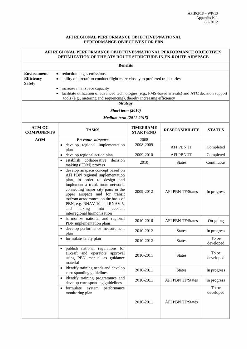
APIRG/18 – WP/13
Appendix K-1 8/2/2012
AFI REGIONAL PERFORMANCE OBJECTIVES/NATIONAL
PERFORMANCE OBJECTIVES FOR PBN
AFI REGIONAL PERFORMANCE OBJECTIVES/NATIONAL PERFORMANCE OBJECTIVES
OPTIMIZATION OF THE ATS ROUTE STRUCTURE IN EN-ROUTE AIRSPACE
Benefits
Environment reduction in gas emissions
Efficiency
Safety ability of aircraft to conduct flight more closely to preferred trajectories
increase in airspace capacity
facilitate utilization of advanced technologies (e.g., FMS-based arrivals) and ATC decision support
tools (e.g., metering and sequencing), thereby increasing efficiency
Strategy
Short term (2010)
Medium term (2011-2015)
ATM OC
COMPONENTS TASKS
TIMEFRAME
START-END
RESPONSIBILITY
STATUS
AOM En-route airspace 2008
develop regional implementation
plan
2008-2009
AFI PBN TF Completed
develop regional action plan 2009-2010 AFI PBN TF Completed
establish collaborative decision
making (CDM) process 2010 States Continuous
develop airspace concept based on
AFI PBN regional implementation
plan, in order to design and
implement a trunk route network,
connecting major city pairs in the
upper airspace and for transit
to/from aerodromes, on the basis of
PBN, e.g. RNAV 10 and RNAV 5,
and taking into account
interregional harmonization
2009-2012 AFI PBN TF/States In progress
harmonize national and regional
PBN implementation plans 2010-2016 AFI PBN TF/States On-going
develop performance measurement
plan 2010-2012 States In progress
formulate safety plan 2010-2012 States
To be
developed
publish national regulations for
aircraft and operators approval
using PBN manual as guidance
material
2010-2011 States To be
developed
identify training needs and develop
corresponding guidelines 2010-2011 States In progress
identify training programmes and
develop corresponding guidelines 2010-2011 AFI PBN TF/States in progress
formulate system performance
monitoring plan
2010-2011 AFI PBN TF/States
To be
developed

APIRG/18 – WP/13
Appendix K-1 8/2/2012
implementation of en-route ATS
routes 2010-2012 AFI PBN TF/States In progress
monitor implementation progress
in accordance with AFI PBN
implementation plan and State
implementation plan
2010 and beyond AFI PBN TF/States On-going
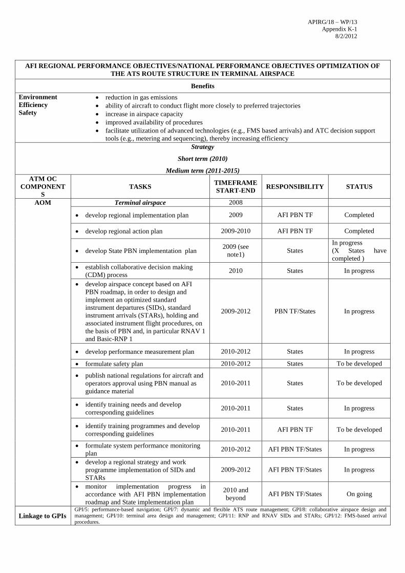
APIRG/18 – WP/13
Appendix K-1 8/2/2012
AFI REGIONAL PERFORMANCE OBJECTIVES/NATIONAL PERFORMANCE OBJECTIVES OPTIMIZATION OF
THE ATS ROUTE STRUCTURE IN TERMINAL AIRSPACE
Benefits
Environment
Efficiency
Safety
reduction in gas emissions
ability of aircraft to conduct flight more closely to preferred trajectories
increase in airspace capacity
improved availability of procedures
facilitate utilization of advanced technologies (e.g., FMS based arrivals) and ATC decision support
tools (e.g., metering and sequencing), thereby increasing efficiency
Strategy
Short term (2010)
Medium term (2011-2015)
ATM OC
COMPONENT
S
TASKS TIMEFRAME
START-END RESPONSIBILITY STATUS
AOM Terminal airspace 2008
develop regional implementation plan 2009 AFI PBN TF Completed
develop regional action plan 2009-2010 AFI PBN TF Completed
develop State PBN implementation plan 2009 (see
note1) States
In progress
(X States have
completed )
establish collaborative decision making
(CDM) process 2010 States In progress
develop airspace concept based on AFI
PBN roadmap, in order to design and
implement an optimized standard
instrument departures (SIDs), standard
instrument arrivals (STARs), holding and
associated instrument flight procedures, on
the basis of PBN and, in particular RNAV 1
and Basic-RNP 1
2009-2012 PBN TF/States In progress
develop performance measurement plan 2010-2012 States In progress
formulate safety plan 2010-2012 States To be developed
publish national regulations for aircraft and
operators approval using PBN manual as
guidance material
2010-2011 States To be developed
identify training needs and develop
corresponding guidelines 2010-2011 States In progress
identify training programmes and develop
corresponding guidelines 2010-2011 AFI PBN TF To be developed
formulate system performance monitoring
plan 2010-2012 AFI PBN TF/States In progress
develop a regional strategy and work
programme implementation of SIDs and
STARs
2009-2012 AFI PBN TF/States In progress
monitor implementation progress in
accordance with AFI PBN implementation
roadmap and State implementation plan
2010 and
beyond AFI PBN TF/States On going
Linkage to GPIs GPI/5: performance-based navigation; GPI/7: dynamic and flexible ATS route management; GPI/8: collaborative airspace design and management; GPI/10: terminal area design and management; GPI/11: RNP and RNAV SIDs and STARs; GPI/12: FMS-based arrival
procedures.
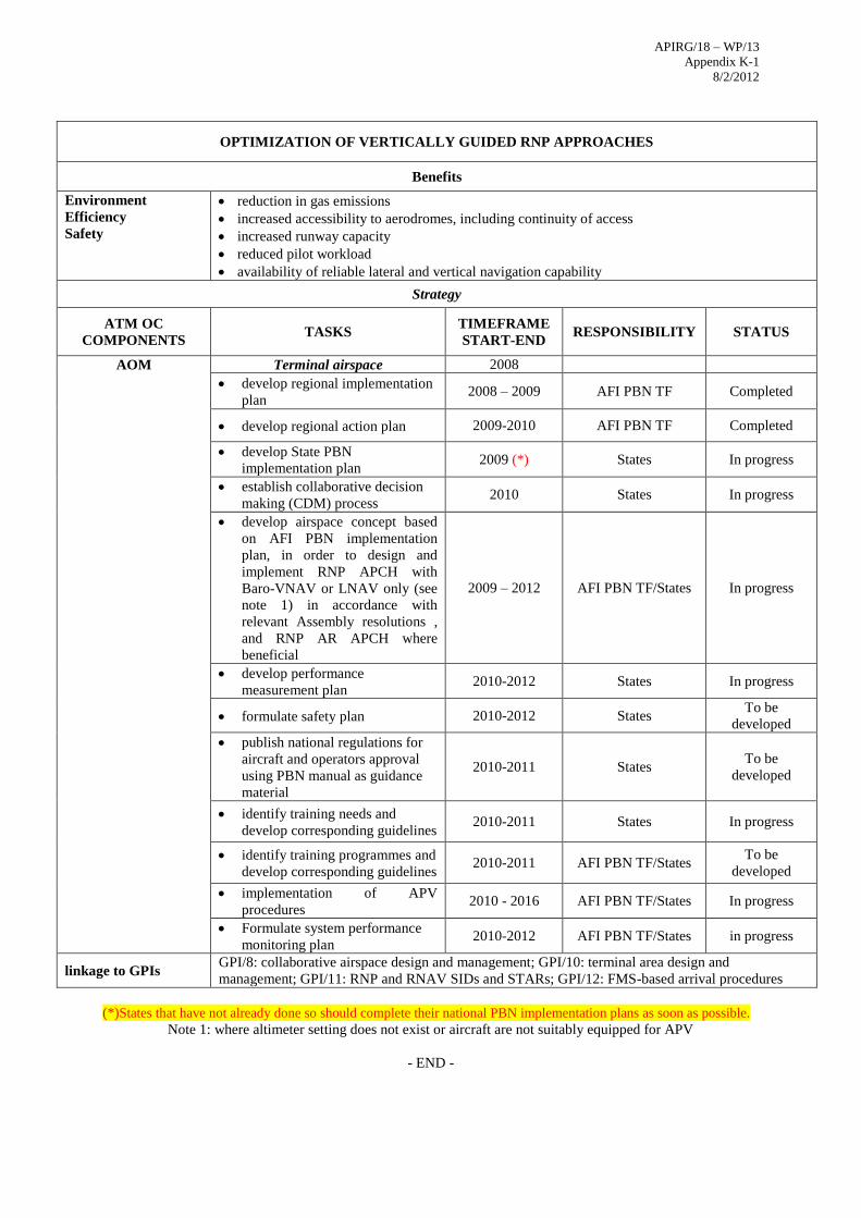
APIRG/18 – WP/13
Appendix K-1 8/2/2012
OPTIMIZATION OF VERTICALLY GUIDED RNP APPROACHES
Benefits
Environment
Efficiency
Safety
reduction in gas emissions
increased accessibility to aerodromes, including continuity of access
increased runway capacity
reduced pilot workload
availability of reliable lateral and vertical navigation capability
Strategy
ATM OC
COMPONENTS TASKS
TIMEFRAME
START-END RESPONSIBILITY STATUS
AOM Terminal airspace 2008
develop regional implementation
plan 2008 – 2009 AFI PBN TF Completed
develop regional action plan 2009-2010 AFI PBN TF Completed
develop State PBN
implementation plan 2009 (*) States In progress
establish collaborative decision
making (CDM) process 2010 States In progress
develop airspace concept based
on AFI PBN implementation
plan, in order to design and
implement RNP APCH with
Baro-VNAV or LNAV only (see
note 1) in accordance with
relevant Assembly resolutions ,
and RNP AR APCH where
beneficial
2009 – 2012 AFI PBN TF/States In progress
develop performance
measurement plan 2010-2012 States In progress
formulate safety plan 2010-2012 States To be
developed
publish national regulations for
aircraft and operators approval
using PBN manual as guidance
material
2010-2011 States To be
developed
identify training needs and
develop corresponding guidelines 2010-2011 States In progress
identify training programmes and
develop corresponding guidelines 2010-2011 AFI PBN TF/States
To be
developed
implementation of APV
procedures 2010 - 2016 AFI PBN TF/States In progress
Formulate system performance
monitoring plan 2010-2012 AFI PBN TF/States in progress
linkage to GPIs GPI/8: collaborative airspace design and management; GPI/10: terminal area design and
management; GPI/11: RNP and RNAV SIDs and STARs; GPI/12: FMS-based arrival procedures
(*)States that have not already done so should complete their national PBN implementation plans as soon as possible.
Note 1: where altimeter setting does not exist or aircraft are not suitably equipped for APV
- END -
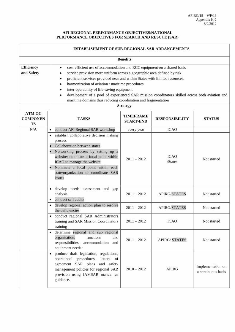
APIRG/18 – WP/13
Appendix K-2 8/2/2012
AFI REGIONAL PERFORMANCE OBJECTIVES/NATIONAL
PERFORMANCE OBJECTIVES FOR SEARCH AND RESCUE (SAR)
ESTABLISHMENT OF SUB-REGIONAL SAR ARRANGEMENTS
Benefits
Efficiency cost-efficient use of accommodation and RCC equipment on a shared basis
and Safety service provision more uniform across a geographic area defined by risk
proficient services provided near and within States with limited resources.
harmonization of aviation / maritime procedures
inter-operability of life-saving equipment
development of a pool of experienced SAR mission coordinators skilled across both aviation and
maritime domains thus reducing coordination and fragmentation
Strategy
ATM OC
COMPONEN
TS
TASKS TIMEFRAME
START-END
RESPONSIBILITY
STATUS
N/A conduct AFI Regional SAR workshop every year ICAO
establish collaborative decision making
process
Collaboration between states
Networking process by setting up a
website; nominate a focal point within
ICAO to manage the website
Nominate a focal point within each
state/organization to coordinate SAR
issues
2011 – 2012 ICAO
/States Not started
develop needs assessment and gap
analysis
conduct self audits
2011 – 2012 APIRG/STATES Not started
develop regional action plan to resolve
the deficiencies 2011 – 2012 APIRG/STATES Not started
conduct regional SAR Administrators
training and SAR Mission Coordinators
training
2011 – 2012 ICAO Not started
determine regional and sub regional
organisation, functions and
responsibilities, accommodation and
equipment needs.:
2011 – 2012 APIRG/ STATES Not started
produce draft legislation, regulations,
operational procedures, letters of
agreement SAR plans and safety
management policies for regional SAR
provision using IAMSAR manual as
guidance.
2010 – 2012 APIRG Implementation on
a continuous basis
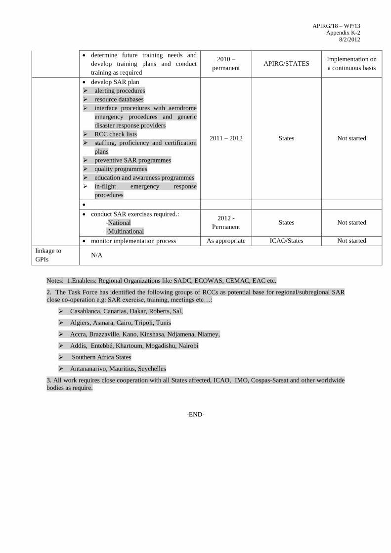
APIRG/18 – WP/13
Appendix K-2 8/2/2012
determine future training needs and
develop training plans and conduct
training as required
2010 –
permanent APIRG/STATES
Implementation on
a continuous basis
develop SAR plan
alerting procedures
resource databases
interface procedures with aerodrome
emergency procedures and generic
disaster response providers
RCC check lists
staffing, proficiency and certification
plans
preventive SAR programmes
quality programmes
education and awareness programmes
in-flight emergency response
procedures
2011 – 2012 States Not started
conduct SAR exercises required.:
-National
-Multinational
2012 -
Permanent States Not started
monitor implementation process As appropriate ICAO/States Not started
linkage to
GPIs N/A
Notes: 1.Enablers: Regional Organizations like SADC, ECOWAS, CEMAC, EAC etc.
2. The Task Force has identified the following groups of RCCs as potential base for regional/subregional SAR
close co-operation e.g: SAR exercise, training, meetings etc…:
Casablanca, Canarias, Dakar, Roberts, Sal,
Algiers, Asmara, Cairo, Tripoli, Tunis
Accra, Brazzaville, Kano, Kinshasa, Ndjamena, Niamey,
Addis, Entebbé, Khartoum, Mogadishu, Nairobi
Southern Africa States
Antananarivo, Mauritius, Seychelles
3. All work requires close cooperation with all States affected, ICAO, IMO, Cospas-Sarsat and other worldwide
bodies as require.
-END-
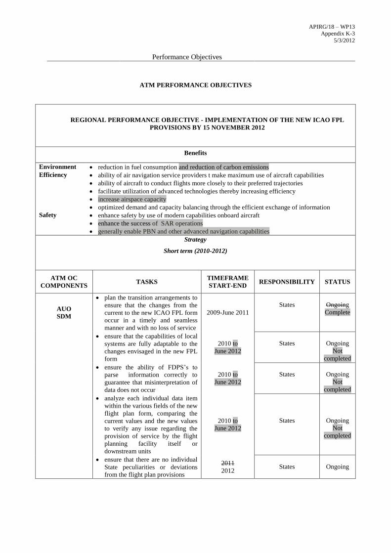
APIRG/18 – WP13
Appendix K-3
5/3/2012
Performance Objectives
ATM PERFORMANCE OBJECTIVES
REGIONAL PERFORMANCE OBJECTIVE - IMPLEMENTATION OF THE NEW ICAO FPL
PROVISIONS BY 15 NOVEMBER 2012
Benefits
Environment reduction in fuel consumption and reduction of carbon emissions
Efficiency ability of air navigation service providers t make maximum use of aircraft capabilities
ability of aircraft to conduct flights more closely to their preferred trajectories
facilitate utilization of advanced technologies thereby increasing efficiency
increase airspace capacity
optimized demand and capacity balancing through the efficient exchange of information
Safety enhance safety by use of modern capabilities onboard aircraft
enhance the success of SAR operations
generally enable PBN and other advanced navigation capabilities
Strategy
Short term (2010-2012)
ATM OC
COMPONENTS TASKS
TIMEFRAME
START-END
RESPONSIBILITY
STATUS
AUO
SDM
plan the transition arrangements to
ensure that the changes from the
current to the new ICAO FPL form
occur in a timely and seamless
manner and with no loss of service
2009-June 2011
States
Ongoing
Complete
ensure that the capabilities of local
systems are fully adaptable to the
changes envisaged in the new FPL
form
2010 to
June 2012
States
Ongoing
Not
completed
ensure the ability of FDPS’s to
parse information correctly to
guarantee that misinterpretation of
data does not occur
2010 to
June 2012
States
Ongoing
Not
completed
analyze each individual data item
within the various fields of the new
flight plan form, comparing the
current values and the new values
to verify any issue regarding the
provision of service by the flight
planning facility itself or
downstream units
2010 to
June 2012
States
Ongoing
Not
completed
ensure that there are no individual
State peculiarities or deviations
from the flight plan provisions
2011
2012
States
Ongoing
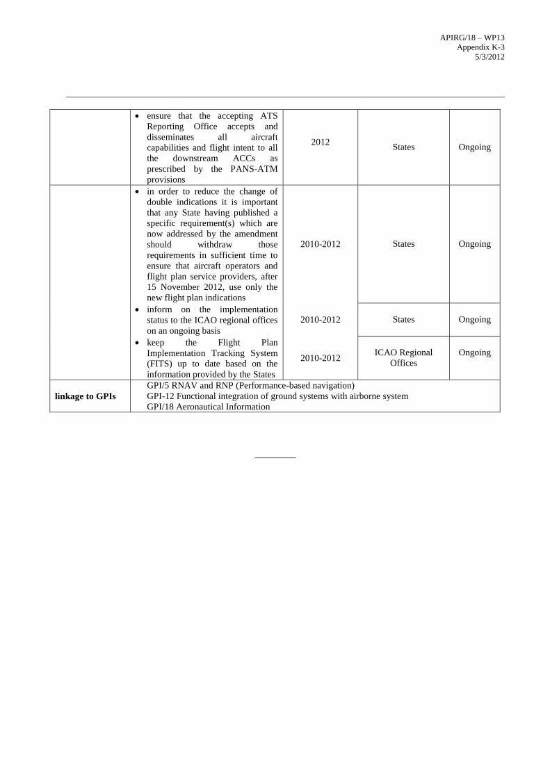
APIRG/18 – WP13
Appendix K-3
5/3/2012
ensure that the accepting ATS
Reporting Office accepts and
disseminates all aircraft
capabilities and flight intent to all
the downstream ACCs as
prescribed by the PANS-ATM
provisions
2012
States
Ongoing
in order to reduce the change of
double indications it is important
that any State having published a
specific requirement(s) which are
now addressed by the amendment
should withdraw those
requirements in sufficient time to
ensure that aircraft operators and
flight plan service providers, after
15 November 2012, use only the
new flight plan indications
2010-2012
States
Ongoing
inform on the implementation
status to the ICAO regional offices
on an ongoing basis
2010-2012
States
Ongoing
keep the Flight Plan
Implementation Tracking System
(FITS) up to date based on the
information provided by the States
2010-2012
ICAO Regional
Offices
Ongoing
linkage to GPIs
GPI/5 RNAV and RNP (Performance-based navigation)
GPI-12 Functional integration of ground systems with airborne system
GPI/18 Aeronautical Information
________