Embed Size (px)
Citation preview
Geoscience Frontiers xxx (2014) 1e10
Contents lists available at ScienceDirect
China University of Geosciences (Beijing)
Geoscience Frontiers
journal homepage: www.elsevier .com/locate/gsf
Research paper
Constraints on the geodynamic evolution of the AfricaeIberia platemargin across the Gibraltar Strait from seismic tomography
S. Monna a,*, A. Argnani b, G.B. Cimini a, F. Frugoni a, C. Montuori a
a Istituto Nazionale di Geofisica e Vulcanologia, Rome, Italyb Istituto di Scienze Marine e Consiglio Nazionale delle Ricerche, Bologna, Italy
a r t i c l e i n f o
Article history:Received 15 November 2013Received in revised form24 January 2014Accepted 6 February 2014Available online xxx
Keywords:AfricaeIberia plate marginTeleseismic tomographyVelocity anomalyMantle upwellingLithospheric subduction
* Corresponding author. Tel.: þ39 (0) 651860404.E-mail address: [email protected] (S. Monna).
Peer-review under responsibility of China University
Production and hosting by Els
1674-9871/$ e see front matter � 2014, China Univerhttp://dx.doi.org/10.1016/j.gsf.2014.02.003
Please cite this article in press as: Monna,Gibraltar Strait from seismic tomography, G
a b s t r a c t
Geophysical studies point to a complex tectonic and geodynamic evolution of the Alboran Basin and Gulfof Cadiz. Tomographic images show strong seismic waves velocity contrasts in the upper mantle. Thehigh velocity anomaly beneath the Alboran Sea recovered by a number of studies is now a well estab-lished feature. Several geodynamic reconstructions have been proposed also on the base of these images.We present and elaborate on results coming from a recent tomography study which concentrates on boththe Alboran and the adjacent Atlantic region. These new results, while they confirm the existence of thefast anomaly below the Alboran region, also show interesting features of the lithosphere-asthenospheresystem below the Atlantic. A high velocity body is imaged roughly below the Horseshoe Abyssal plaindown to sub-lithospheric depths. This feature suggests either a possible initiation or relic subduction.Pronounced low velocity anomalies pervade the upper mantle below the Atlantic region and separate thelithospheres of the two regions. We also notice a strong change of the upper mantle velocity structuregoing from south to north across the Gorringe Bank. This variation in structure could be related to thedifferent evolution in the opening of the central and northern Atlantic oceans.
� 2014, China University of Geosciences (Beijing) and Peking University. Production and hosting byElsevier B.V. All rights reserved.
1. Introduction
The geodynamic evolution of the Gulf of Cadiz/Alboran Basinregion is the result of the complex interaction between central andnorthern Atlantic oceanic domains, and the African and Eurasianplates (Fig. 1). Observations on magnetic anomalies and seismicdata suggest that the central and northern Atlantic oceans openedat different times, although the precise age of the early oceaniccrust is still debated (e.g., Labails et al., 2010; Bronner et al., 2011;Sibuet et al., 2012). Spreading occurred in early Jurassic in thecentral Atlantic and in early Cretaceous in the northern Atlantic. Inthe Iberian margin of North Atlantic mantle exhumation has been
of Geosciences (Beijing)
evier
sity of Geosciences (Beijing) and P
S., et al., Constraints on theeoscience Frontiers (2014), h
inferred to play a major role in the early opening stage (Bronneret al., 2011), whereas magnetic anomalies in the central Atlanticindicate that accretion is markedly asymmetric, with more oceaniccrust produced on the American side (Labails et al., 2010; Sibuetet al., 2012). Interestingly, this last observation is connected tothe occurrence, on the African side, of the central Atlantic magmaticprovince (Labails et al., 2010). The Gibraltar-Newfoundland Frac-ture Zone (GNFZ) is the northern limit of the central Atlantic, and isalso the zone of transfer of spreading into the Alpine Tethyanseaway in Jurassic times. In the western Tethyan region conver-gence between Eurasia (Iberia) and Africa plates started by Eocene,leading to consumption of the plate margins and to the presentgeological setting (Platt et al., 2013 and references therein). Atpresent the convergence between the two plates is at a rate ofw5 mm/yr (Stich et al., 2006; Serpelloni et al., 2007). The Africa-Eurasia plate boundary is clearly defined from the Gloria fault tothe Gorringe Bank (McKenzie, 1972; Srivastava et al., 1990; Zitelliniet al., 2009). From the Gorringe Bank proceeding to the east, acrossthe Strait of Gibraltar, the boundary is diffuse (McKenzie, 1972;Sartori et al., 1994; Serpelloni et al., 2007) with different locationshaving been proposed for it. A narrow band of deformation (SWIMFault Zone), is considered as a precursor to the formation of a new
eking University. Production and hosting by Elsevier B.V. All rights reserved.
geodynamic evolution of the AfricaeIberia plate margin across thettp://dx.doi.org/10.1016/j.gsf.2014.02.003
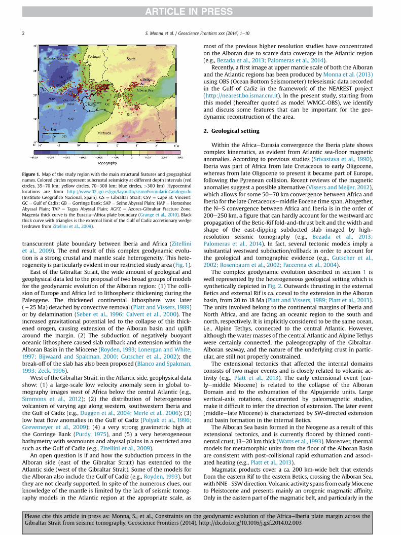
Figure 1. Map of the study region with the main structural features and geographicalnames. Colored circles represent subcrustal seismicity at different depth intervals (redcircles, 35e70 km; yellow circles, 70e300 km; blue circles, >300 km). Hypocentrallocations are from http://www.02.ign.es/ign/layoutIn/sismoFormularioCatalogo.do(Instituto Geográfico Nacional, Spain). GS ¼ Gibraltar Strait; CSV ¼ Cape St. Vincent;GC ¼ Gulf of Cadiz; GB ¼ Gorringe Bank; SAP ¼ Seine Abyssal Plain; HAP ¼ HorseshoeAbyssal Plain; TAP ¼ Tagus Abyssal Plain; AGFZ ¼ Azores-Gibraltar Fracture Zone.Magenta thick curve is the EurasiaeAfrica plate boundary (Grange et al., 2010). Blackthick curve with triangles is the external limit of the Gulf of Cadiz accretionary wedge(redrawn from Zitellini et al., 2009).
S. Monna et al. / Geoscience Frontiers xxx (2014) 1e102
transcurrent plate boundary between Iberia and Africa (Zitelliniet al., 2009). The end result of this complex geodynamic evolu-tion is a strong crustal and mantle scale heterogeneity. This hete-rogeneity is particularly evident in our restricted study area (Fig. 1).
East of the Gibraltar Strait, the wide amount of geological andgeophysical data led to the proposal of two broad groups of modelsfor the geodynamic evolution of the Alboran region: (1) The colli-sion of Europe and Africa led to lithospheric thickening during thePaleogene. The thickened continental lithosphere was later(w25 Ma) detached by convective removal (Platt and Vissers, 1989)or by delamination (Seber et al., 1996; Calvert et al., 2000). Theincreased gravitational potential led to the collapse of this thick-ened orogen, causing extension of the Alboran basin and upliftaround the margin. (2) The subduction of negatively buoyantoceanic lithosphere caused slab rollback and extension within theAlboran Basin in the Miocene (Royden, 1993; Lonergan and White,1997; Bijwaard and Spakman, 2000; Gutscher et al., 2002); thebreak-off of the slab has also been proposed (Blanco and Spakman,1993; Zeck, 1996).
West of the Gibraltar Strait, in the Atlantic side, geophysical datashow: (1) a large-scale low velocity anomaly seen in global to-mography images west of Africa below the central Atlantic (e.g.,Simmons et al., 2012); (2) the distribution of heterogeneousvolcanism of varying age along western, southwestern Iberia andthe Gulf of Cadiz (e.g., Duggen et al., 2004; Merle et al., 2006); (3)low heat flow anomalies in the Gulf of Cadiz (Polyak et al., 1996;Grevemeyer et al., 2009); (4) a very strong gravimetric high atthe Gorringe Bank (Purdy, 1975), and (5) a very heterogeneousbathymetry with seamounts and abyssal plains in a restricted areasuch as the Gulf of Cadiz (e.g., Zitellini et al., 2009).
An open question is if and how the subduction process in theAlboran side (east of the Gibraltar Strait) has extended to theAtlantic side (west of the Gibraltar Strait). Some of the models forthe Alboran also include the Gulf of Cadiz (e.g., Royden, 1993), butthey are not clearly supported. In spite of the numerous clues, ourknowledge of the mantle is limited by the lack of seismic tomog-raphy models in the Atlantic region at the appropriate scale, as
Please cite this article in press as: Monna, S., et al., Constraints on theGibraltar Strait from seismic tomography, Geoscience Frontiers (2014), h
most of the previous higher resolution studies have concentratedon the Alboran due to scarce data coverage in the Atlantic region(e.g., Bezada et al., 2013; Palomeras et al., 2014).
Recently, a first image at upper mantle scale of both the Alboranand the Atlantic regions has been produced by Monna et al. (2013)using OBS (Ocean Bottom Seismometer) teleseismic data recordedin the Gulf of Cadiz in the framework of the NEAREST project(http://nearest.bo.ismar.cnr.it). In the present study, starting fromthis model (hereafter quoted as model WMGC-OBS), we identifyand discuss some features that can be important for the geo-dynamic reconstruction of the area.
2. Geological setting
Within the AfricaeEurasia convergence the Iberia plate showscomplex kinematics, as evident from Atlantic sea-floor magneticanomalies. According to previous studies (Srivastava et al., 1990),Iberia was part of Africa from late Cretaceous to early Oligocene,whereas from late Oligocene to present it became part of Europe,following the Pyrenean collision. Recent reviews of the magneticanomalies suggest a possible alternative (Vissers and Meijer, 2012),which allows for some 50e70 km convergence between Africa andIberia for the late Cretaceousemiddle Eocene time span. Altogether,the NeS convergence between Africa and Iberia is in the order of200e250 km, a figure that can hardly account for the westward arcpropagation of the Betic-Rif fold-and-thrust belt and the width andshape of the east-dipping subducted slab imaged by high-resolution seismic tomography (e.g., Bezada et al., 2013;Palomeras et al., 2014). In fact, several tectonic models imply asubstantial westward subduction/rollback in order to account forthe geological and tomographic evidence (e.g., Gutscher et al.,2002; Rosenbaum et al., 2002; Faccenna et al., 2004).
The complex geodynamic evolution described in section 1 iswell represented by the heterogeneous geological setting which issynthetically depicted in Fig. 2. Outwards thrusting in the externalBetics and external Rif is ca. coeval to the extension in the Alboranbasin, from 20 to 18 Ma (Platt and Vissers, 1989; Platt et al., 2013).The units involved belong to the continental margins of Iberia andNorth Africa, and are facing an oceanic region to the south andnorth, respectively. It is implicitly considered to be the same ocean,i.e., Alpine Tethys, connected to the central Atlantic. However,although the water masses of the central Atlantic and Alpine Tethyswere certainly connected, the paleogeography of the Gibraltar-Alboran seaway, and the nature of the underlying crust in partic-ular, are still not properly constrained.
The extensional tectonics that affected the internal domainsconsists of two major events and is closely related to volcanic ac-tivity (e.g., Platt et al., 2013). The early extensional event (ear-lyemiddle Miocene) is related to the collapse of the AlboranDomain and to the exhumation of the Alpujarride units. Largevertical-axis rotations, documented by paleomagnetic studies,make it difficult to infer the direction of extension. The later event(middleelate Miocene) is characterized by SW-directed extensionand basin formation in the internal Betics.
The Alboran Sea basin formed in the Neogene as a result of thisextensional tectonics, and is currently floored by thinned conti-nental crust, 13e20 km thick (Watts et al., 1993). Moreover, thermalmodels for metamorphic units from the floor of the Alboran Basinare consistent with post-collisional rapid exhumation and associ-ated heating (e.g., Platt et al., 2013).
Magmatic products cover a ca. 200 km-wide belt that extendsfrom the eastern Rif to the eastern Betics, crossing the Alboran Sea,withNNEeSSWdirection. Volcanic activity spans fromearlyMioceneto Pleistocene and presents mainly an orogenic magmatic affinity.Only in the eastern part of the magmatic belt, and particularly in the
geodynamic evolution of the AfricaeIberia plate margin across thettp://dx.doi.org/10.1016/j.gsf.2014.02.003
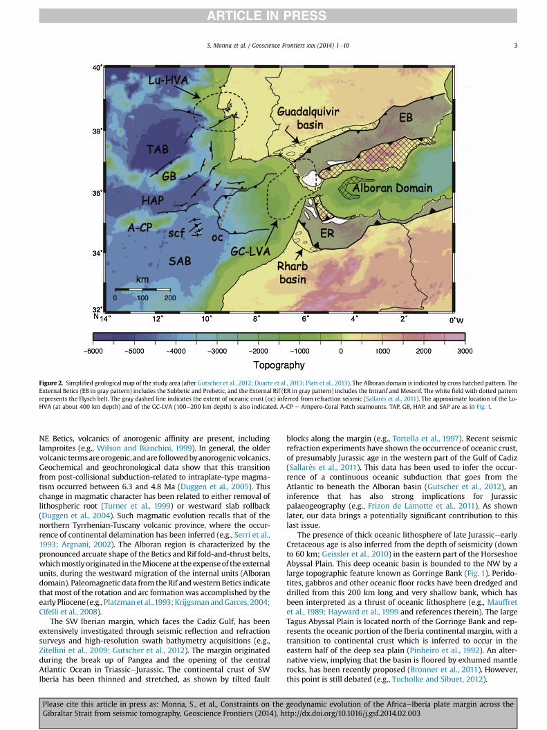
Figure 2. Simplified geological map of the study area (after Gutscher et al., 2012; Duarte et al., 2013; Platt et al., 2013). The Alboran domain is indicated by cross hatched pattern. TheExternal Betics (EB in gray pattern) includes the Subbetic and Prebetic, and the External Rif (ER in gray pattern) includes the Intrarif and Mesorif. The white field with dotted patternrepresents the Flysch belt. The gray dashed line indicates the extent of oceanic crust (oc) inferred from refraction seismic (Sallarès et al., 2011). The approximate location of the Lu-HVA (at about 400 km depth) and of the GC-LVA (100e200 km depth) is also indicated. A-CP ¼ Ampere-Coral Patch seamounts. TAP, GB, HAP, and SAP are as in Fig. 1.
S. Monna et al. / Geoscience Frontiers xxx (2014) 1e10 3
NE Betics, volcanics of anorogenic affinity are present, includinglamproites (e.g., Wilson and Bianchini, 1999). In general, the oldervolcanic termsareorogenic, andare followedbyanorogenicvolcanics.Geochemical and geochronological data show that this transitionfrom post-collisional subduction-related to intraplate-type magma-tism occurred between 6.3 and 4.8 Ma (Duggen et al., 2005). Thischange in magmatic character has been related to either removal oflithospheric root (Turner et al., 1999) or westward slab rollback(Duggen et al., 2004). Such magmatic evolution recalls that of thenorthern Tyrrhenian-Tuscany volcanic province, where the occur-rence of continental delamination has been inferred (e.g., Serri et al.,1993; Argnani, 2002). The Alboran region is characterized by thepronounced arcuate shape of the Betics and Rif fold-and-thrust belts,whichmostlyoriginated in theMioceneat theexpenseof the externalunits, during the westward migration of the internal units (Alborandomain). Paleomagnetic data from theRif andwesternBetics indicatethat most of the rotation and arc formationwas accomplished by theearly Pliocene (e.g., Platzmanet al.,1993;KrijgsmanandGarces, 2004;Cifelli et al., 2008).
The SW Iberian margin, which faces the Cadiz Gulf, has beenextensively investigated through seismic reflection and refractionsurveys and high-resolution swath bathymetry acquisitions (e.g.,Zitellini et al., 2009; Gutscher et al., 2012). The margin originatedduring the break up of Pangea and the opening of the centralAtlantic Ocean in TriassiceJurassic. The continental crust of SWIberia has been thinned and stretched, as shown by tilted fault
Please cite this article in press as: Monna, S., et al., Constraints on theGibraltar Strait from seismic tomography, Geoscience Frontiers (2014), h
blocks along the margin (e.g., Tortella et al., 1997). Recent seismicrefraction experiments have shown the occurrence of oceanic crust,of presumably Jurassic age in the western part of the Gulf of Cadiz(Sallarès et al., 2011). This data has been used to infer the occur-rence of a continuous oceanic subduction that goes from theAtlantic to beneath the Alboran basin (Gutscher et al., 2012), aninference that has also strong implications for Jurassicpalaeogeography (e.g., Frizon de Lamotte et al., 2011). As shownlater, our data brings a potentially significant contribution to thislast issue.
The presence of thick oceanic lithosphere of late JurassiceearlyCretaceous age is also inferred from the depth of seismicity (downto 60 km; Geissler et al., 2010) in the eastern part of the HorseshoeAbyssal Plain. This deep oceanic basin is bounded to the NW by alarge topographic feature known as Gorringe Bank (Fig. 1). Perido-tites, gabbros and other oceanic floor rocks have been dredged anddrilled from this 200 km long and very shallow bank, which hasbeen interpreted as a thrust of oceanic lithosphere (e.g., Mauffretet al., 1989; Hayward et al., 1999 and references therein). The largeTagus Abyssal Plain is located north of the Gorringe Bank and rep-resents the oceanic portion of the Iberia continental margin, with atransition to continental crust which is inferred to occur in theeastern half of the deep sea plain (Pinheiro et al., 1992). An alter-native view, implying that the basin is floored by exhumed mantlerocks, has been recently proposed (Bronner et al., 2011). However,this point is still debated (e.g., Tucholke and Sibuet, 2012).
geodynamic evolution of the AfricaeIberia plate margin across thettp://dx.doi.org/10.1016/j.gsf.2014.02.003
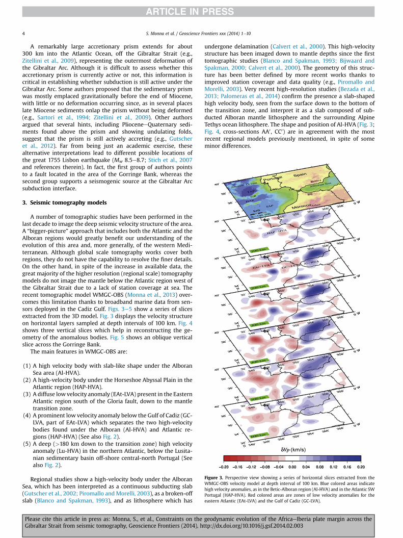
Figure 3. Perspective view showing a series of horizontal slices extracted from theWMGC-OBS velocity model at depth interval of 100 km. Blue colored areas indicatehigh velocity anomalies, as in the Betic-Alboran region (Al-HVA) and in the Atlantic SWPortugal (HAP-HVA). Red colored areas are zones of low velocity anomalies for theeastern Atlantic (EAt-LVA) and the Gulf of Cadiz (GC-LVA).
S. Monna et al. / Geoscience Frontiers xxx (2014) 1e104
A remarkably large accretionary prism extends for about300 km into the Atlantic Ocean, off the Gibraltar Strait (e.g.,Zitellini et al., 2009), representing the outermost deformation ofthe Gibraltar Arc. Although it is difficult to assess whether thisaccretionary prism is currently active or not, this information iscritical in establishing whether subduction is still active under theGibraltar Arc. Some authors proposed that the sedimentary prismwas mostly emplaced gravitationally before the end of Miocene,with little or no deformation occurring since, as in several placeslate Miocene sediments onlap the prism without being deformed(e.g., Sartori et al., 1994; Zitellini et al., 2009). Other authorsargued that several hints, including PlioceneeQuaternary sedi-ments found above the prism and showing undulating folds,suggest that the prism is still actively accreting (e.g., Gutscheret al., 2012). Far from being just an academic exercise, thesealternative interpretations lead to different possible locations ofthe great 1755 Lisbon earthquake (Mw 8.5e8.7; Stich et al., 2007and references therein). In fact, the first group of authors pointsto a fault located in the area of the Gorringe Bank, whereas thesecond group supports a seismogenic source at the Gibraltar Arcsubduction interface.
3. Seismic tomography models
A number of tomographic studies have been performed in thelast decade to image the deep seismic velocity structure of the area.A “bigger-picture” approach that includes both the Atlantic and theAlboran regions would greatly benefit our understanding of theevolution of this area and, more generally, of the western Medi-terranean. Although global scale tomography works cover bothregions, they do not have the capability to resolve the finer details.On the other hand, in spite of the increase in available data, thegreat majority of the higher resolution (regional scale) tomographymodels do not image the mantle below the Atlantic region west ofthe Gibraltar Strait due to a lack of station coverage at sea. Therecent tomographic model WMGC-OBS (Monna et al., 2013) over-comes this limitation thanks to broadband marine data from sen-sors deployed in the Cadiz Gulf. Figs. 3e5 show a series of slicesextracted from the 3D model. Fig. 3 displays the velocity structureon horizontal layers sampled at depth intervals of 100 km. Fig. 4shows three vertical slices which help in reconstructing the ge-ometry of the anomalous bodies. Fig. 5 shows an oblique verticalslice across the Gorringe Bank.
The main features in WMGC-OBS are:
(1) A high velocity body with slab-like shape under the AlboranSea area (Al-HVA).
(2) A high-velocity body under the Horseshoe Abyssal Plain in theAtlantic region (HAP-HVA).
(3) A diffuse low velocity anomaly (EAt-LVA) present in the EasternAtlantic region south of the Gloria fault, down to the mantletransition zone.
(4) A prominent low velocity anomaly below the Gulf of Cadiz (GC-LVA, part of EAt-LVA) which separates the two high-velocitybodies found under the Alboran (Al-HVA) and Atlantic re-gions (HAP-HVA) (See also Fig. 2).
(5) A deep (>180 km down to the transition zone) high velocityanomaly (Lu-HVA) in the northern Atlantic, below the Lusita-nian sedimentary basin off-shore central-north Portugal (Seealso Fig. 2).
Regional studies show a high-velocity body under the AlboranSea, which has been interpreted as a continuous subducting slab(Gutscher et al., 2002; Piromallo andMorelli, 2003), as a broken-offslab (Blanco and Spakman, 1993), and as lithosphere which has
Please cite this article in press as: Monna, S., et al., Constraints on theGibraltar Strait from seismic tomography, Geoscience Frontiers (2014), h
undergone delamination (Calvert et al., 2000). This high-velocitystructure has been imaged down to mantle depths since the firsttomographic studies (Blanco and Spakman, 1993; Bijwaard andSpakman, 2000; Calvert et al., 2000). The geometry of this struc-ture has been better defined by more recent works thanks toimproved station coverage and data quality (e.g., Piromallo andMorelli, 2003). Very recent high-resolution studies (Bezada et al.,2013; Palomeras et al., 2014) confirm the presence a slab-shapedhigh velocity body, seen from the surface down to the bottom ofthe transition zone, and interpret it as a slab composed of sub-ducted Alboran mantle lithosphere and the surrounding AlpineTethys ocean lithosphere. The shape and position of Al-HVA (Fig. 3;Fig. 4, cross-sections AA0 , CC0) are in agreement with the mostrecent regional models previously mentioned, in spite of someminor differences.
geodynamic evolution of the AfricaeIberia plate margin across thettp://dx.doi.org/10.1016/j.gsf.2014.02.003
S. Monna et al. / Geoscience Frontiers xxx (2014) 1e10 5
Lateral heterogeneity in the upper mantle beneath westernMediterranean and adjacent Atlantic region is also imaged byglobal travel time tomography (Bijwaard and Spakman, 2000;Montelli et al., 2004; Li et al., 2008; Simmons et al., 2012, amongmany others). These tomographic models are designed to imagelarge-scale seismic structure in the whole mantle for the primarypurpose of understanding the convective processes within theEarth’s interior (Grand et al., 1997). The recent global-scale P wavevelocity model LLNL-G3Dv3 developed by Simmons et al. (2012),which takes advantage of a more complex representation of theEarth’s stratification (relative to a purely spherical model) and usesa multiscale inversion approach (called PMTI) to capture also thefine details (where data are sufficient), reveals interesting featuresin the lithosphere-asthenosphere system of the study region. Themost relevant aspects of model LLNL-G3Dv3 that can be comparedto the features of model WMGC-OBS, are: the pronounced highvelocity anomaly, as large as þ2.5% (with respect to the mean ve-locity of 8.1 km/s), imaged from the Moho to at least 115 km depthin the Atlantic region southwest Portugal, and the large-scale lowvelocity anomaly (�1.0%) between the Atlantic Ridge and north-west Africa, which extends from 265 km down to the lower mantle(see Fig. 9, Simmons et al., 2012). The fast structure at 115 km depthcorresponds well to our HAP-HVA below the Horseshoe AbyssalPlain (Fig. 4, cross-sections AA0 , BB0, and Fig. 5), suggesting that it isa reliable upper mantle structure. The northerly portion of thelarge-scale low velocity anomaly in the central Atlantic is alsocaptured by the WMGC-OBS model southwest of the western Ibe-rian margin. The low velocity volume EAt-LVA in our study area ischaracterized by a larger velocity contrast (w�2%) with respect tothe broad LLNL-G3Dv3 low velocity anomaly.
4. Discussion
Seismic tomography gives us a snapshot of the current velocityheterogeneity which can help us answer some open problemsregarding the geodynamic evolution of this area. One of the keyquestions concerns the present relation between the Atlantic andAlboran regions. Recent studies based on extensive deployment oftemporary land seismic arrays, both on the Iberian Peninsula andNorth Africa (Topo-Iberia, http://www.ictja.csic.es/gt/rc/LSD/PRJ/indexTOPOIBERIA.html; PICASSO, https://earth.usc.edu/research/picasso/home), are able to focus with high resolution on theAlboran region. The shape of the high velocity body below theAlboran region has been well imaged in a recent paper (Bezadaet al., 2013) where the slab appears disconnected (torn off) fromthe Iberian plate under the Betics. The Al-HVA of our model isconsistent with the Alboran slab imaged by these high resolutionstudies, pointing to a former oceanic domain now entirely sub-ducted. These land-based studies, however, do not give informationon the transition towards the Atlantic region. Model WMGC-OBS isa first attempt to image this transition at upper-mantle scale basedon the integration of marine (OBS) and land data. A major resultevident from themodel is that there is not a continuity between thefast structures imaged in the two regions. In fact, the high-velocitybody (Al-HVA) under the Alboran Sea area is interrupted at itswestern side by a pronounced low-velocity anomaly (GC-LVA;Figs. 2 and 4, cross-section AA0). Fig. 6 is a 3D rendition of the high(A) and low (B) upper mantle velocity heterogeneity. These plotssuggest a more articulate reconstruction than one based on east-ward subduction underneath the Alboran of a single oceanic slabconnected to the Atlantic domain (e.g., Royden, 1993; Gutscheret al., 2002).
What more can we say about the Atlantic region? HAP-HVA isimaged in an area roughly underlying the Horseshoe Abyssal Plain,where the plate boundary passes from a linear transform to a
Please cite this article in press as: Monna, S., et al., Constraints on theGibraltar Strait from seismic tomography, Geoscience Frontiers (2014), h
diffuse convergent margin, and where the occurrence of Jurassicoceanic lithosphere is inferred (Hayward et al., 1999; Zitellini et al.,2009; Geissler et al., 2010). The thickness of HAP-HVA(w80e150 km in cross sections AA0eBB0; Fig. 4) does agree withvalues proposed in literature for old (w140Ma) oceanic lithosphere(McKenzie et al., 2005; Conrad and Lithgow-Bertelloni, 2006). Thepresence of oceanic crust, of presumably Jurassic age, has also beensupported by a seismic refraction profile in the Gulf of Cadiz(Sallarès et al., 2011). The HAP-HVA is interrupted to the east by thewell resolved GC-LVA seen in model WMGC-OBS.
The position and geometry of HAP-HVA, dipping in the south-east direction within the upper mantle, suggest the presence ofsubducted lithosphere (Fig. 5). The Gorringe Bank has been iden-tified by Gurnis et al. (2004), from geodynamic modeling based ongeophysical and geological information, as an incipient margin thatcould develop into a subduction zone. In this view the GorringeBank is an early stage system undergoing a forced style of subduc-tion driven by compression. The shortening accommodated acrossthe Gorringe Bank and adjacent structures has been estimated torange fromw50 km (Hayward et al., 1999) to a minimum of 20 km(Jiménez-Munt et al., 2010) on the basis of flexural isostatic models.
In spite of possible vertical smearing of the velocity anomalies,our images show a continuous, narrow and steep slab which rea-ches at least 350 km depth, suggesting a developed subductionprocess well beyond the early stage. The occurrence of a thickenedoceanic lithosphere which has accommodated the shorteningcaused by AfricaeIberia convergence (Jiménez-Munt et al., 2011),does not seem appropriate to explain the HAP-HVA given the depthextent of the high velocity body. In fact, assuming a 120 km thickoceanic lithosphere, the subducted slab is about 250 km long,suggesting that AfricaeIberia convergence has been accommo-dated in this structure since some millions of years. Future seis-mological investigations with larger instrumental coverage of thisarea need to be carried out for a better definition of the geometry ofthe subducted slab.
Subduction initiation in this area may be due to the convergencecomponent rather than foundering of a negatively buoyant litho-sphere, as no evidence of extensional tectonics has been reported inthe upper plate of the Horseshoe Abyssal Plain, where compres-sional earthquake focal mechanisms are found (e.g., Stich et al.,2007). Furthermore, our tomographic results indicate that sub-duction is limited to the Gorringe Bank structure and it may berelated to a lateral change from strike slip to transpression alongthe Gloria fault (Serpelloni et al., 2007).
The tomographic evidence of limited subduction underneaththe Horseshoe Abyssal Plain, physically separated by the largerAlboran slab (Al-HVA), points to a different scenario with respect tothose proposed by Duarte et al. (2013) for the active tectonics of theregion: the Gibraltar subduction is mostly inactive, as suggested bygeodetic data which show small to none differential motion acrossthe Gibraltar Strait (Stich et al., 2006; Serpelloni et al., 2007). On theother hand, AfricaeIberia convergence is active and it is accom-modated by significant shortening in the Gorringe Bank-Horseshoeregion (Jiménez-Munt et al., 2011).
Interestingly, most of the subcrustal seismicity located in thisarea is included in HAP-HVA (Fig. 5). Furthermore, two recentstrong earthquakes have been located below the Horseshoe abyssalPlain (Fukao, 1973; Stich et al., 2007) and are found at the top of thedescending lithosphere (Fig. 5). Our tomographic results supportthe interpretation that the Gorringe Bank-Horseshoe region couldbe the possible source area of the great 1755 Lisbon tsunamigenicearthquake, as suggested by other authors (e.g., Stich et al., 2007and references therein), and contrast with the hypothesis of asource located at the subduction interface underneath the GibraltarArc (e.g., Gutscher et al., 2012 and references therein).
geodynamic evolution of the AfricaeIberia plate margin across thettp://dx.doi.org/10.1016/j.gsf.2014.02.003
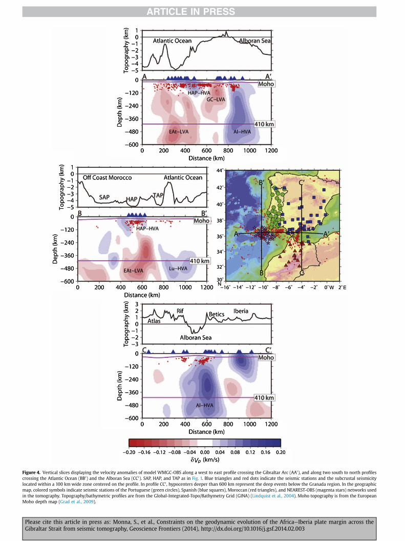
Figure 4. Vertical slices displaying the velocity anomalies of model WMGC-OBS along a west to east profile crossing the Gibraltar Arc (AA0), and along two south to north profilescrossing the Atlantic Ocean (BB0) and the Alboran Sea (CC0). SAP, HAP, and TAP as in Fig. 1. Blue triangles and red dots indicate the seismic stations and the subcrustal seismicitylocated within a 100 km wide zone centered on the profile. In profile CC0 , hypocenters deeper than 600 km represent the deep events below the Granada region. In the geographicmap, colored symbols indicate seismic stations of the Portuguese (green circles), Spanish (blue squares), Moroccan (red triangles), and NEAREST-OBS (magenta stars) networks usedin the tomography. Topography/bathymetric profiles are from the Global-Integrated-Topo/Bathymetry Grid (GINA) (Lindquist et al., 2004). Moho topography is from the EuropeanMoho depth map (Grad et al., 2009).
Please cite this article in press as: Monna, S., et al., Constraints on the geodynamic evolution of the AfricaeIberia plate margin across theGibraltar Strait from seismic tomography, Geoscience Frontiers (2014), http://dx.doi.org/10.1016/j.gsf.2014.02.003
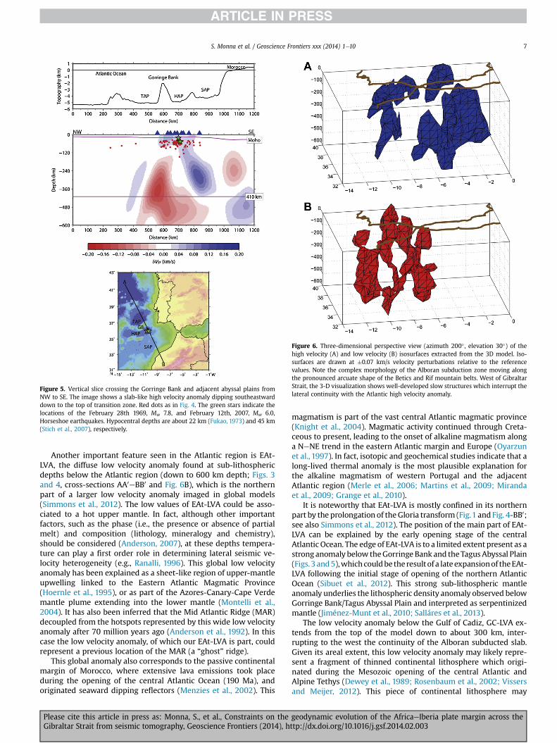
Figure 6. Three-dimensional perspective view (azimuth 200� , elevation 30�) of thehigh velocity (A) and low velocity (B) isosurfaces extracted from the 3D model. Iso-surfaces are drawn at �0.07 km/s velocity perturbations relative to the referencevalues. Note the complex morphology of the Alboran subduction zone moving alongthe pronounced arcuate shape of the Betics and Rif mountain belts. West of GibraltarStrait, the 3-D visualization shows well-developed slow structures which interrupt thelateral continuity with the Atlantic high velocity anomaly.
Figure 5. Vertical slice crossing the Gorringe Bank and adjacent abyssal plains fromNW to SE. The image shows a slab-like high velocity anomaly dipping southeastwarddown to the top of transition zone. Red dots as in Fig. 4. The green stars indicate thelocations of the February 28th 1969, Mw 7.8, and February 12th, 2007, Mw 6.0,Horseshoe earthquakes. Hypocentral depths are about 22 km (Fukao, 1973) and 45 km(Stich et al., 2007), respectively.
S. Monna et al. / Geoscience Frontiers xxx (2014) 1e10 7
Another important feature seen in the Atlantic region is EAt-LVA, the diffuse low velocity anomaly found at sub-lithosphericdepths below the Atlantic region (down to 600 km depth; Figs. 3and 4, cross-sections AA0eBB0 and Fig. 6B), which is the northernpart of a larger low velocity anomaly imaged in global models(Simmons et al., 2012). The low values of EAt-LVA could be asso-ciated to a hot upper mantle. In fact, although other importantfactors, such as the phase (i.e., the presence or absence of partialmelt) and composition (lithology, mineralogy and chemistry),should be considered (Anderson, 2007), at these depths tempera-ture can play a first order role in determining lateral seismic ve-locity heterogeneity (e.g., Ranalli, 1996). This global low velocityanomaly has been explained as a sheet-like region of upper-mantleupwelling linked to the Eastern Atlantic Magmatic Province(Hoernle et al., 1995), or as part of the Azores-Canary-Cape Verdemantle plume extending into the lower mantle (Montelli et al.,2004). It has also been inferred that the Mid Atlantic Ridge (MAR)decoupled from the hotspots represented by this wide low velocityanomaly after 70 million years ago (Anderson et al., 1992). In thiscase the low velocity anomaly, of which our EAt-LVA is part, couldrepresent a previous location of the MAR (a “ghost” ridge).
This global anomaly also corresponds to the passive continentalmargin of Morocco, where extensive lava emissions took placeduring the opening of the central Atlantic Ocean (190 Ma), andoriginated seaward dipping reflectors (Menzies et al., 2002). This
Please cite this article in press as: Monna, S., et al., Constraints on theGibraltar Strait from seismic tomography, Geoscience Frontiers (2014), h
magmatism is part of the vast central Atlantic magmatic province(Knight et al., 2004). Magmatic activity continued through Creta-ceous to present, leading to the onset of alkaline magmatism alonga NeNE trend in the eastern Atlantic margin and Europe (Oyarzunet al., 1997). In fact, isotopic and geochemical studies indicate that along-lived thermal anomaly is the most plausible explanation forthe alkaline magmatism of western Portugal and the adjacentAtlantic region (Merle et al., 2006; Martins et al., 2009; Mirandaet al., 2009; Grange et al., 2010).
It is noteworthy that EAt-LVA is mostly confined in its northernpart by the prolongation of theGloria transform (Fig.1 andFig. 4-BB0;see also Simmons et al., 2012). The position of the main part of EAt-LVA can be explained by the early opening stage of the centralAtlantic Ocean. The edge of EAt-LVA is to a limited extent present as astrong anomaly below theGorringe Bank and theTagusAbyssal Plain(Figs. 3 and5),whichcouldbe theresultof a lateexpansionof theEAt-LVA following the initial stage of opening of the northern AtlanticOcean (Sibuet et al., 2012). This strong sub-lithospheric mantleanomaly underlies the lithospheric density anomaly observed belowGorringe Bank/Tagus Abyssal Plain and interpreted as serpentinizedmantle (Jiménez-Munt et al., 2010; Salláres et al., 2013).
The low velocity anomaly below the Gulf of Cadiz, GC-LVA ex-tends from the top of the model down to about 300 km, inter-rupting to the west the continuity of the Alboran subducted slab.Given its areal extent, this low velocity anomaly may likely repre-sent a fragment of thinned continental lithosphere which origi-nated during the Mesozoic opening of the central Atlantic andAlpine Tethys (Dewey et al., 1989; Rosenbaum et al., 2002; Vissersand Meijer, 2012). This piece of continental lithosphere may
geodynamic evolution of the AfricaeIberia plate margin across thettp://dx.doi.org/10.1016/j.gsf.2014.02.003
S. Monna et al. / Geoscience Frontiers xxx (2014) 1e108
indicate that the Tethyan margin between Africa and Iberia was acontinental transform that linked the oceanic crust of the Horse-shoe and Seine Abyssal plains to the oceanic Alpine Tethys. Themost relevant implication for this paleogeographic interpretation isthat this buoyant continental lithosphere may have caused theextinction of the westward rollback of the Alpine Tethys oceaniclithosphere, while entering subduction. This interpretation agreeswith paleomagnetic data that show that oroclinal bending ended inearly Pliocene or earlier (e.g., Platt et al., 2003, Cifelli et al., 2008)and also with the present day GPS velocity filed, which shows thatthe Betics and Rif units in the Gibraltar Strait are currently movingtogether with the African region located north of the Atlas (e.g.,Serpelloni et al., 2007).
Finally, in the resolved part of our model below the Europeanplate we find a deep high velocity anomaly, Lu-HVA (Figs. 2 and 4,profile BB0) which resides in the mesosphere (400e650 km depth),the regionwhere slabs may accumulate (Anderson et al., 1992). Thishigh velocity body is located below the Variscan belt of Portugal.The Variscan orogeny took place from about 350 to 300 Ma (e.g.,Matte, 2001), contributing to the assembly of Pangea. The highvelocity body could therefore represent a relic subducted slab.Similar relics of Variscan subduction are interpreted to occur un-derneath the Paris Basin, where a high velocity anomaly is presentin the upper mantle (Averbuch and Piromallo, 2012). Pre-Variscanpalaeoreconstructions suggest that western Iberia had a differentevolution with respect to NW Africa, (e.g., Frizon de Lamotte et al.,2013). Interestingly, the transform zone (GNFZ) that separated theVariscan belt of Europe from the Appalachian-Mauritanian belt isinferred to run more or less along the present day Gloria Fault. Thislong-term evolution may have originated mantle heterogeneitythat varies north and south of the Gloria Fault. The subsequentimpinging of the eastern Atlantic magmatic activity may have alsooverprinted any pre-existing mantle features on the African plate.
5. Conclusions
The tomographic images of the upper mantle below thesouthwestern Iberian margin-Alboran region presented in thisstudy can help us better understand the lithosphere-asthenospheresystem across the Gibraltar Strait. Two clear high velocity anoma-lies of oceanic nature have been imaged in the Atlantic (HAP-HVA)and Alboran (Al-HVA) regions. The passage from the Atlantic to theAlboran is characterized by the pronounced low velocity anomalyGC-LVA which separates the high velocity lithospheres (HAP-HVAand Al-HVA), thus excluding the existence of a single slab sub-ducting from the Cadiz Gulf under the Alboran region. Velocitycontrasts between the fast/slow structures are 3 to 5%. In ourinterpretation GC-LVA represents a thinned continental lithospherewhich separated the Alboran and Atlantic oceanic domains.
The geometry of HAP-HVA below the Horseshoe abyssal plain,is consistent with the presence of a limited subduction zone (of ca.250 km) underlying the Horseshoe Abyssal Plain, driven by plateconvergence. This evidence suggests that compression in the re-gion comprising the Gorringe Bank-Horseshoe Abyssal Plainpossibly started earlier than expected on the basis lithosphericthickening only.
A diffuse volume of low velocity, EAt-LVA, extends from north-west Africa to southwest Iberia and from the surface down to thebottom of our model. This EAt-LVA is mostly confined in itsnorthern part by the prolongation of the Gloria transform, and itmay have originated in the Jurassic, during the opening of thecentral Atlantic Ocean.
In this study we presented and discussed new images extractedfrom the tomographic modelWMGC-OBS. Ourmodel clarifies someaspects and at the same time opens new questions on the upper
Please cite this article in press as: Monna, S., et al., Constraints on theGibraltar Strait from seismic tomography, Geoscience Frontiers (2014), h
mantle structure and on the plate-tectonic evolution of this area.We hope that this new information will prompt further discussionand reinterpretation of the wide amount of acquired geophysicaland geological data.
Acknowledgments
We thank the Guest Editor M. Yoshida for inviting us to partic-ipate to this special volume. We appreciated the constructive sug-gestions of the reviewer, which improved the manuscript. The OBSteleseismic data was collected during the NEAREST EC-project(coordinator N. Zitellini). We thank the NEAREST Working Groupformaking the seismic data available. The figureswere produced byusing GMT (Wessel and Smith, 1991). We thank an anonymousreviewer for helping us improve our paper.
References
Anderson, D.L., 2007. New Theory of the Earth, second ed., p. 408. http://dx.doi.org/10.2277/0521849594
Anderson, D.L., Tanimoto, T., Zhang, Y., 1992. Plate tectonics and hotspots: the thirddimension. Science 256, 1645e1651.
Argnani, A., 2002. The Northern Apennines and the kinematics of Africa-Europeconvergence. Bollettino della Società Geologica Italiana vol. spec. 1, 47e60.
Averbuch, O., Piromallo, C., 2012. Is there a remnant Variscan subducted slab in themantle beneath the Paris basin? Implications for the late Variscan lithosphericdelamination process and the Paris basin formation. Tectonophysics 558e559,70e83.
Bezada, M.J., Humphreys, E.D., Toomey, D.R., Harnafi, M., Dávila, J.M., Gallart, J.,2013. Evidence for slab rollback in westernmost Mediterranean from improvedupper mantle imaging. Earth and Planetary Science Letters 368, 51e60.
Bijwaard, H., Spakman, W., 2000. Nonlinear global P-wave tomography by iteratedlinearised inversion. Geophysical Journal International 141, 71e82.
Blanco, M.J., Spakman, W., 1993. The P-wave velocity structure of the mantle belowthe Iberian Peninsula: evidence for a subducted lithosphere below southernSpain. Tectonophysics 221, 13e34.
Bronner, A., Sauter, D., Manatschal, G., Péron-Pinvidic, G., Munschy, M., 2011.Magmatic breakup as an explanation for magnetic anomalies at magma-poorrifted margins. Nature Geoscience 4 (8), 549e553.
Calvert, A., Sandvol, E., Seber, D., Barazangi, M., Vidal, F., Alguacil, G., Jabour, N.,2000. Propagation of regional seismic phases (Lg and Sn) and Pn velocitystructure along the AfricaeIberia plate boundary zone: tectonic implications.Geophysical Journal International 142, 384e408. http://dx.doi.org/10.1046/j.1365-246x.2000.00160.x.
Cifelli, F., Mattei, M., Porreca, M., 2008. New paleomagnetic data from Oligocene-eupper Miocene sediments in the Rif chain (northern Morocco): Insights on theNeogene tectonic evolution of the Gibraltar arc. Journal of Geophysical Research113, B02104. http://dx.doi.org/10.1029/2007JB005271.
Conrad, C.P., Lithgow-Bertelloni, C., 2006. Influence of continental roots andasthenosphere on plate-mantle coupling. Geophysical Research Letters 33,L05312. http://dx.doi.org/10.1029/2005GL025621.
Dewey, J.F., Helman, M.L., Turco, E., Hutton, D.H.W., Knott, S.D., 1989. Kinematics ofthe western Mediterranean. In: Coward, M.P., Dietrich, D., Park, R.G. (Eds.),Alpine Tectonics, Geological Society, London, Special Publication, pp. 265e283.
Duarte, J.C., Rosas, F.M., Terrinha, P., Shellart, W.P., Boutelier, D., Gutscher, M.-A.,Ribeiro, A., 2013. Are subduction zones invading the Atlantic ? Evidence fromthe southwest Iberia margin. Geology. http://dx.doi.org/10.1130/G34100.1.
Duggen, S., Hoernle, K., Van Den Bogaard, P., Harris, C., 2004. Magmatic evolution ofthe Alboran Region: the role of subduction in forming the western Mediterra-nean and causing the Messinian Salinity Crisis. Earth and Planetary ScienceLetters 218, 91e108.
Duggen, S., Hoernle, K., Van Den Bogaard, P., Garbe-Schönberg, D., 2005. Post-Collisional transition from subduction to intraplate-type magmatism in thewesternmost Mediterranean: evidence for continental-edge delamination ofsubcontinental lithosphere. Journal of Petrology 46 (6), 1155e1201. http://dx.doi.org/10.1093/petrology/egi013.
Faccenna, C., Piromallo, C., Crespo-Blanc, A., Jolivet, L., Rossetti, F., 2004. Lateral slabdeformation and the origin of the western Mediterranean arcs. Tectonics 23.http://dx.doi.org/10.1029/2002TC001488.
Frizon de Lamotte, D., Raulin, C., Mouchot, N., Wrobel-Daveau, J.-C., Blanpied, C.,Ringenbach, J.-C., 2011. The southernmost margin of the Tethys realm duringthe Mesozoic and Cenozoic: initial geometry and timing of the inversion pro-cesses. Tectonics 30, TC3002. http://dx.doi.org/10.1029/2010TC002691.
Frizon de Lamotte, D., Tavakoli-Shirazi, S., Leturmy, P., Averbuch, O., Mouchot, N.,Raulin, C., Leparmentier, F., Blanpied, C., Ringenbach, J.-C., 2013. Evidence forLate Devonian vertical movements and extensional deformation in northernAfrica and Arabia: integration in the geodynamics of the Devonian world.Tectonics 32, 107e122. http://dx.doi.org/10.1002/tect.20007.
geodynamic evolution of the AfricaeIberia plate margin across thettp://dx.doi.org/10.1016/j.gsf.2014.02.003
S. Monna et al. / Geoscience Frontiers xxx (2014) 1e10 9
Fukao, Y., 1973. Thrust faulting at a lithospheric plate boundary. The Portugalearthquake of 1969. Earth and Planetary Science Letters 18, 205e216.
Geissler, W.H., Matias, L., Stich, D., Carrilho, F., Jokat, W., Monna, S., IbenBrahim, A.,Mancilla, F., Gutscher, M.-A., Sallarès, V., Zitellini, N., 2010. Focal mechanisms forsubecrustal earthquakes in the Gulf of Cadiz from a dense OBS deployment.Geophysical Research Letters 37, L18309. http://dx.doi.org/10.1029/2010GL044289.
Grad, M., Tiira, T., ESC Working Group, 2009. The Moho depth map of the EuropeanPlate. Geophysical Journal International 176, 279e292. http://dx.doi.org/10.1111/j.1365-246X.2008.03919.x.
Grand, S.P., Van der Hilst, R.D., Widiyantoro, S., 1997. Global seismic tomography: asnapshot of convection in the Earth. GSA Today 7, 1e7.
Grange, M., Schärer, U., Merle, R., Girardeau, J., Cornen, G., 2010. Plume-lithosphereinteraction during migration of cretaceous alkaline magmatism in SW Portugal:evidence from U-Pb ages and Pb-Sr-Hf isotopes. Journal of Petrology 51 (5),1143e1170.
Grevemeyer, I., Kaul, N., Kop, A., 2009. Heat flow anomalies in the Gulf of Cadiz andoff Cape San Vincente, Portugal. Marine and Petroleum Geology 26, 795e804.
Gurnis, M., Hall, C., Lavier, L., 2004. Evolving force balance during incipient sub-duction. Geochemistry Geophysics Geosystems 5, Q07001. http://dx.doi.org/10.1029/2003GC000681.
Gutscher, M.-A., Malod, J., Rehault, J.P., Contrucci, I., Klingelhoefer, F.,MendeseVictor, L., Spakman, W., 2002. Evidence for active subduction beneathGibraltar. Geology 30, 1071e1074. http://dx.doi.org/10.1130/0091-7613.
Gutscher, M.-A., Dominguez, S., Westbrook, G.K., Le Roy, P., Rosas, F., Duarte, J.C.,Terrinha, P., Miranda, J.M., Graindorge, D., Gailler, A., Sallares, V., Bartolome, R.,2012. The Gibraltar subduction: a decade of new geophysical data. Tectono-physics 574, 72e91. http://dx.doi.org/10.1016/j.tecto.2012.08.038.
Hayward, N., Watts, A.B., Westbrook, G.K., Collier, J.S., 1999. A seismic reflection andGLORIA study of compressional deformation in the Gorringe Bank region,eastern North Atlantic. Geophysical Journal International 138, 831e850.
Hoernle, K., Zhang, Y.-S., Graham, D., 1995. Seismic and geochemical evidence forlarge-scale mantle upwelling beneath the eastern Atlantic and western andcentral Europe. Nature 374, 34e39.
Jiménez-Munt, I., Fernàndez, M., Vergés, J., Afonso, J.C., Garcia-Castellanos, D.,Fullea, J., 2010. Lithospheric structure of the Gorringe Bank: insights into itsorigin and tectonic evolution. Tectonics 29, TC5019. http://dx.doi.org/10.1029/2009TC002458.
Jiménez-Munt, I., Fernàndez, M., Vergés, J., Garcia-Castellanos, D., Fullea, J., Pérez-Gussinyé, M., Afonso, J.C., 2011. Decoupled crust-mantle accommodation ofAfrica-Eurasia convergence in the NWMoroccan margin. Journal of GeophysicalResearch 116, B08403. http://dx.doi.org/10.1029/2010JB008105.
Knight, K.B., Nomade, S., Renne, P.R., Marzoli, A., Bertrand, H., Youbi, N., 2004. TheCentral Atlantic Magmatic Province at the TriassiceJurassic boundary: paleo-magnetic and 40Ar/39Ar evidence from Morocco for brief, episodic volcanism.Earth and Planetary Science Letters 228, 143e160.
Krijgsman, W., Garces, M., 2004. Paleomagnetic constrains on the geodynamicevolution of the Gibraltar Arc. Terra Nova 16, 281e287.
Labails, C., Olivet, J.-L., Aslanian, D., Roest, W.R., 2010. An alternative early openingscenario for the Central Atlantic Ocean. Earth and Planetary Science Letters 297,355e368.
Li, C., van der Hilst, R.D., Engdahl, E.R., Burdick, S., 2008. A new global model for Pwave speed variations in Earth’s mantle. Geochemistry Geophysics Geosystems9, Q05018. http://dx.doi.org/10.1029/2007GC001806.
Lindquist, K.G., Engle, K., Stahlke, D., Price, E., 2004. Global topography and ba-thymetry grid improves research efforts. Eos Transactions American Geophys-ical Union 85 (19), 186.
Lonergan, L., White, N., 1997. Origin of the Betic-Rif mountain belt. Tectonics 16,504e522.
Martins, L.T., Madeira, J., Youbi, N., Munhá, J., Mata, J., Kerrich, R., 2009. Rift-relatedmagmatism of the Central Atlantic magmatic province in Algarve, SouthernPortugal. Lithos 101, 102e124.
Mauffret, A., Mougenot, D., Miles, P.R., Malod, J.A., 1989. Cenozoic deformation andMesozoic abandoned spreading centre in the Tagus Abyssal Plain (westPortugal): result of a multichannel seismic survey. Canadian Journal EarthScience 26, 1101e1123.
Matte, P., 2001. The Variscan collage and orogeny (480e290 Ma) and the tectonicdefinition of the Armorica microplate: a review. Terra Nova 13, 122e128. http://dx.doi.org/10.1046/j.1365-3121.2001.00327.x.
McKenzie, D.P., 1972. Active tectonics of the Mediterranean region. GeophysicalJournal of the Royal Astronomical Society 30, 109e185.
McKenzie, D., Jackson, J., Priestley, K., 2005. Thermal structure of oceanic andcontinental lithosphere. Earth and Planetary Science Letters 233, 337e349.
Menzies, M., Klemperer, S.L., Ebinger, C.,J., Baker, J., 2002. Characteristics of volcanicrifted margins. In: Geological Society of America Special Paper 362, pp. 1e14.
Merle, R., Schärer, U., Girardeau, J., Cornen, G., 2006. Cretaceous seamounts alongthe continent-ocean transition of the Iberian margin: U-Pb ages and Pb-Sr-Hfisotopes. Geochimica et Cosmochimica Acta 70, 4950e4976.
Miranda, R., Valadares, V., Terrinha, P., Mata, J., do Rosario Azevedo, M., Gaspar, M.,Kulberg, J.C., Ribeiro, C., 2009. Age constraints on the Late Cretaceous alkalinemagmatism on the West Iberian Margin. Cretaceous Research 30, 575e586.
Monna, S., Cimini, G.B., Montuori, C., Matias, L., Geissler, W.H., Favali, P., 2013. Newinsights from seismic tomography on the complex geodynamic evolution oftwo adjacent domains: Gulf of Cadiz and Alboran Sea. Journal of GeophysicalResearch 118. http://dx.doi.org/10.1029/2012JB009607.
Please cite this article in press as: Monna, S., et al., Constraints on theGibraltar Strait from seismic tomography, Geoscience Frontiers (2014), h
Montelli, R., Nolet, G., Dahlen, F.A., Masters, G., Engdahl, E.R., Hung, S.H., 2004.Finite-frequency tomography reveals a variety of plumes in the mantle. Science303 (5656), 338e343.
Oyarzun, R., Doblas, M., López-Ruiz, J., Cebrá, J.M., 1997. Opening of the centralAtlantic and asymmetric mantle upwelling phenomena: implications for long-lived magmatism in western North Africa and Europe. Geology 25, 727e730.
Palomeras, I., Thurner, S., Levander, A., Liu, K., Villasenor, A., Carbonell, R.,Harnafi, M., 2014. Finite-frequency Rayleigh wave tomography of the westernMediterranean: mapping its lithospheric structure. Geochemistry GeophysicsGeosystems 15. http://dx.doi.org/10.1002/2013GC004861.
Pinheiro, L.M., Whitmarsh, R.B., Miles, P.R., 1992. The ocean-continent boundary offthe western continental margin of Iberia-II: crustal structure in the TagusAbyssal Plain. Geophysical Journal International 109, 106e124.
Piromallo, C., Morelli, A., 2003. P wave tomography of the mantle under the Alpine-Mediterranean area. Journal of Geophysical Research 108 (B2), 2065. http://dx.doi.org/10.1029/2002JB001757.
Platt, J.P., Allerton, S., Kirker, A., Mandeville, C., Mayfield, A., Platzman, E.S., Rimi, A.,2003. The ultimate arc: differential displacement, oroclinal bending, and ver-tical axis rotation in the external Betic-Rif arc. Tectonics 3 (22), 1017. http://dx.doi.org/10.1029/2001TC001321.
Platt, J.P., Behr, W.M., Johanesen, K., Williams, Jason R., 2013. The Betic-Rif Arc andits orogenic hinterland: a review. Annual Review of Earth and Planetary Sci-ences 41, 313e357.
Platt, J.P., Vissers, R.L.M., 1989. Extensional collapse of thickened continental lith-osphere: a working hypothesis for the Alboran Sea and the Gibraltar arc. Ge-ology 17, 540e543.
Platzman, E.S., Platt, J.P., Olivier, P., 1993. Palaeomagnetic rotations and fault kine-matics in the Rif arc of Morocco. Journal of the Geological Society, London 150,707e718.
Polyak, B.G., Fernàndez, M., Khutorskoy, M.D., Soto, J.I., Basov, I.A., Comas, M.C.,Khain, V.Y., Alonso, B., Agapova, G.V., Mazurova, I.S., Negredo, A., Tochitsky, V.O.,Linde, J. d. l., Bogdanov, N.A., Banda, E., 1996. Heat flow in the Alboran Sea,western Mediterranean. Tectonophysics 263, 191e218.
Purdy, G.M., 1975. The eastern end of the Azores-Gibraltar plate boundary.Geophysical Journal of the Royal Astronomical Society 43, 973e1000.
Ranalli, G., 1996. Seismic tomography and mineral physics. In: Boschi, E.,Ekström, G., Morelli, A. (Eds.), Seismic Modelling of the Earth Structure. IstitutoNazionale di Geofisica, Rome, pp. 443e459.
Rosenbaum, G., Lister, G.S., Dubosz, C., 2002. Relative motions of Africa, Iberia andEurope during Alpine orogeny. Tectonophysics 359, 117e129.
Royden, L.H., 1993. Evolution of retreating subduction boundaries formed duringcontinental collision. Tectonics 12, 629e638.
Sallarès, V., Gailler, A., Gutscher, M.-A., Graindorge, D., Bartolomé, R., Gràcia, E.,Díaz, J., Dañobeitia, J., Zitellini, N., 2011. Seismic evidence for the presence ofJurassic oceanic crust in the central Gulf of Cadiz (SW Iberian margin). Earthand Planetary Science Letters. http://dx.doi.org/10.1016/j.epsl.2011.09.003.
Sallarès, V., Martínez-Loriente, S., Prada, M., Gràcia, E., Ranero, C.R., Gutscher, M.-A.,Bartolomé, R., Gailler, A., Dañobeitia, J.J., Zitellini, N., 2013. Seismic evidence ofexhumed mantle rock basement at the Gorringe Bank and the adjacentHorseshoe and Tagus abyssal plains (SW Iberia). Earth Planetary Science Letters365, 120e131. http://dx.doi.org/10.1016/j.epsl.2013.01.021.
Sartori, R., Torelli, L., Zitellini, N., Peis, D., Lodolo, E., 1994. Eastern segment of theAzoreseGibraltar line (centraleeastern Atlantic): an oceanic plate boundarywith diffuse compressional deformation. Geology 22, 555e558.
Seber, D., Barazangi, M., Ibenbrahim, A., Demnati, A., 1996. Geophysical evidence forlithospheric delamination beneath the Alboran Sea and Rif-Betic mountains.Nature 379, 785e790.
Serri, G., Innocenti, F., Manetti, P.,1993. Geochemical and petrological evidence of thesubduction of delaminated Adriatic continental lithosphere in the genesis of theNeogene-Quaternary magmatism of central Italy. Tectonophysics 223, 117e147.
Serpelloni, E., Vannucci, G., Pondrelli, S., Argnani, A., Casula, G., Anzidei, M., Baldi, P.,Gasperini, P., 2007. Kinematics of the Western Africa-Eurasia plate boundaryfrom focal mechanisms and GPS data. Geophysical Journal International 169,1180e1200. http://dx.doi.org/10.1111/j.1365-246X.2007.03367.x.
Sibuet, J.-C., Rouzo, S., Srivastava, S., 2012. Plate tectonic reconstructions andpaleogeographic maps of the central and north Atlantic oceans. CanadianJournal of Earth Sciences 49, 1395e1415.
Simmons, N.A., Myers, S.C., Johannesson, G., Matzel, E., 2012. LLNL-G3Dv3: global Pwave tomography model for improved regional and teleseismic travel timeprediction. Journal of Geophysical Research 117, B10302. http://dx.doi.org/10.1029/2012JB009525.
Srivastava, S.P., Roest, W.R., Kovacs, L.C., Oakey, G., Lévesque, S., Verhoef, J.,Macnab, R., 1990. Motion of Iberia since the late Jurassic: results from detailedaeromagnetic measurements in the Newfoundland Basin. Tectonophysics 184,229e260. http://dx.doi.org/10.1016/0040-1951(90)90442-b.
Stich, D., Serpelloni, E., Mancilla, F., Morales, J., 2006. Kinematics of the Iberia-Maghreb plate contact from seismic moment tensors and GPS observations.Tectonophysics 426, 295e317.
Stich, D., Mancilla, F., Pondrelli, S., Morales, J., 2007. Source analysis of the February12th 2007, Mw 6.0 Horseshoe earthquake: implications for the 1755 Lisbonearthquake. Geophysical Research Letters 34, L12308. http://dx.doi.org/10.1029/2007GL030012.
Tortella, D., Torne, M., Perez-Estauan, A., 1997. Geodynamic evolution of the Easternsegment of the Azores-Gibraltar fracture zone: the Gorringe Bank and the Gulfof Cadiz region. Marine Geophysical Research 19, 211e230.
geodynamic evolution of the AfricaeIberia plate margin across thettp://dx.doi.org/10.1016/j.gsf.2014.02.003
S. Monna et al. / Geoscience Frontiers xxx (2014) 1e1010
Tucholke, B.E., Sibuet, J.-C., 2012. Problematic plate reconstruction. Nature Geo-science 5, 676e677.
Turner, S.P., Platt, J.P., George, R.M.M., Kelley, S.P., Pearson, D.G., Nowell, G.M., 1999.Magmatism associated with orogenic collapse of the BeticeAlboran Domain, SESpain. Journal of Petrology 40, 1011e1036.
Vissers, R.L.M., Meijer, P. Th, 2012. Iberian plate kinematics and Alpine collision inthe Pyrenees. Earth Science Reviews 114, 61e83.
Watts, A.B., Platt, J.P., Buhl, P., 1993. Tectonic evolution of the Alborán Sea basin.Basin Research 5, 153e177.
Wessel, P., Smith, W.H., 1991. Free software helps map and display data. Eos,Transactions American Geophysical Union 72 (41), 441e446.
Please cite this article in press as: Monna, S., et al., Constraints on theGibraltar Strait from seismic tomography, Geoscience Frontiers (2014), h
Wilson, M., Bianchini, G., 1999. Tertiary-quaternary Magmatism within the Medi-terranean and Surrounding Regions. In: Geological Society, London, SpecialPublication 156, pp. 141e168. http://dx.doi.org/10.1144/GSL.SP.1999.156.01.09.
Zeck, H.P., 1996. Betic-Rif orogeny: subduction of Mesozoic Tethys lithosphere un-der eastward drifting Iberia, slab detachment shortly before 22 Ma, and sub-sequent uplift and extensional tectonics. Tectonophysics 254, 1e16.
Zitellini, N., Gràcia, E., Matias, L., Terrinha, P., Abreu, M.A., De Alteriis, G., Henriet, J.P.,Dañobeita, J.J., Masson, D.G., Mulder, T., Ramella, R., Somoza, L., Diez, S., 2009.The quest for the AfricaeEurasia plate boundary west of the Strait of Gibraltar.Earth and Planetary Science Letters 280, 13e50. http://dx.doi.org/10.1016/j.epsl.2008.12.005.
geodynamic evolution of the AfricaeIberia plate margin across thettp://dx.doi.org/10.1016/j.gsf.2014.02.003