Embed Size (px)
Citation preview
Constraints on the origin and evolution of Iani Chaos, Mars
Nicholas H. Warner,1 Sanjeev Gupta,1 Jung‐Rack Kim,2,3 Jan‐Peter Muller,4
Lucille Le Corre,4 Jeremy Morley,5 Shih‐Yuan Lin,6 and Chris McGonigle1
Received 7 December 2010; revised 4 March 2011; accepted 18 March 2011; published 15 June 2011.
[1] The origin mechanisms and geologic evolution of chaotic terrain on Mars are poorlyconstrained. Iani Chaos, located at the headAres Vallis, is among themost geomorphologicallycomplex of the chaotic terrains. Its morphology is defined by (1) multiple, 1 to 2 kmdeep basins, (2) flat‐topped, fractured plateaus that are remnants of highland terrain,(3) knobby, fractured remnants of highland terrain, (4) plateaus with a knobby surfacemorphology, (5) interchaos grooved terrain, (6) interior layered deposits (ILDs), and(7) mantling material. Topography, the observed geomorphology, and measured fracturepatterns suggest that the interchaos basins formed as a result of subsurface volume loss andcollapse of the crust, likely owing to effusion of groundwater to the surface. Regionalpatterns in fracture orientation indicate that the basins developed along linear zones ofpreexisting weakness in the highland crust. Multiple overlapping basins and fracture systemspoint to multiple stages of collapse at Iani Chaos. Furthermore, the total estimatedvolume loss from the basins (104 km3) is insufficient to explain erosion of 104–105 km3
of material from Ares Vallis by a single flood. Comparisons with the chronology of AresVallis indicate multiple water effusion events from Iani Chaos that span the Hesperian,with termination of activity in the early Amazonian. Recharge of groundwater throughpreexisting fracture systems may explain this long‐lived, but likely episodic, fluvial activity.Late‐stage, early to middle Amazonian aqueous processes may have deposited the ILDs.However, the topography data indicate that the ILDs did not form within lacustrineenvironments.
Citation: Warner, N. H., S. Gupta, J.‐R. Kim, J.‐P. Muller, L. Le Corre, J. Morley, S.‐Y. Lin, and C. McGonigle (2011),Constraints on the origin and evolution of Iani Chaos, Mars, J. Geophys. Res., 116, E06003, doi:10.1029/2010JE003787.
1. Introduction
1.1. Origin of Chaotic Terrains
[2] The chaotic terrains on Mars consist of enclosedand semienclosed basins that are composed of, and are sur-rounded by, extensionally fractured cratered highland terrain[Carr, 1996, 1979; Rodriguez et al., 2005a; Scott andTanaka, 1986; Tanaka et al., 2005]. For any given chaosregion, the fractured highlands exhibit some morphologicvariation between (1) densely fractured knobby terrain/conical mounds and (2) fracture bounded plateaus and mesas.The association of several chaotic terrains with outflow
channels implies that these systems are closely related to acomplex set of processes that caused massive evacuations ofgroundwater onto the surface and collapse of the crust [Bakerand Milton, 1974; Baker, 1982; Baker et al., 1991; Carr,1979; Masursky et al., 1977; Rodriguez et al., 2005a; Sharp,1973].[3] Despite the relative certainty that groundwater played a
major role in the geologic history of many chaotic terrains onMars, the precise mechanism of groundwater release onto thesurface and the long‐term geologic evolution of individualchaos regions remain highly uncertain. Several plausiblehypotheses for the cause of collapse at each chaos region havebeen suggested for both the chaotic regions that are associatedwith floods and those that are not. From image‐based obser-vations, hydrologic modeling, and observed mineralogicalrelationships (e.g., presence of sulfates) these hypotheses areas follows: (1) catastrophic release of water from deep (∼1 to∼2 km) pressurized subsurface aquifers that were previouslyconfined beneath a globally extensive, thick cryosphere[Carr, 1979; Leask et al., 2006; Lucchitta et al., 1994], (2)release of groundwater from confined subsurface caverns[Rodriguez et al., 2003], (3) melting of subsurface or near‐surface ice by an igneous intrusion or subaerial/subglacialvolcanism [Chapman and Tanaka, 2002; Chapman et al.,2003; Leask et al., 2006; Masursky et al., 1977; Maxwelland Picard, 1974; Meresse et al., 2008], (4) release of
1Department of Earth Science and Engineering, Imperial CollegeLondon, London, UK.
2Ziin Consulting, Seoul, South Korea.3Now at Department of Geoinformatics, University of Seoul, Seoul,
Korea.4Mullard Space Science Laboratory, Department of Space and Climate
Physics, University College London, Holmbury St. Mary, UK.5Centre for Geospatial Science, University of Nottingham, Nottingham,
UK.6Department of Land Economics, National Chengchi University,
Taipei, Taiwan.
Copyright 2011 by the American Geophysical Union.0148‐0227/11/2010JE003787
JOURNAL OF GEOPHYSICAL RESEARCH, VOL. 116, E06003, doi:10.1029/2010JE003787, 2011
E06003 1 of 29
groundwater during major impact events [Wang et al., 2005],(5) dewatering of hydrous minerals by subsurface heat (e.g.,igneous intrusions) [Kargel et al., 2007; Montgomery andGillespie, 2005], (6) dissolution of subsurface hydrous clath-rates [Hoffman, 2000;Komatsu et al., 2000;Max and Clifford,2001], (7) melting and collapse of buried water ice in a con-fined basin [Zegers et al., 2010], and (8) sublimation of an ice‐rich substrate [Pedersen and Head, 2010].[4] It is unclear whether a single overarching mechanism
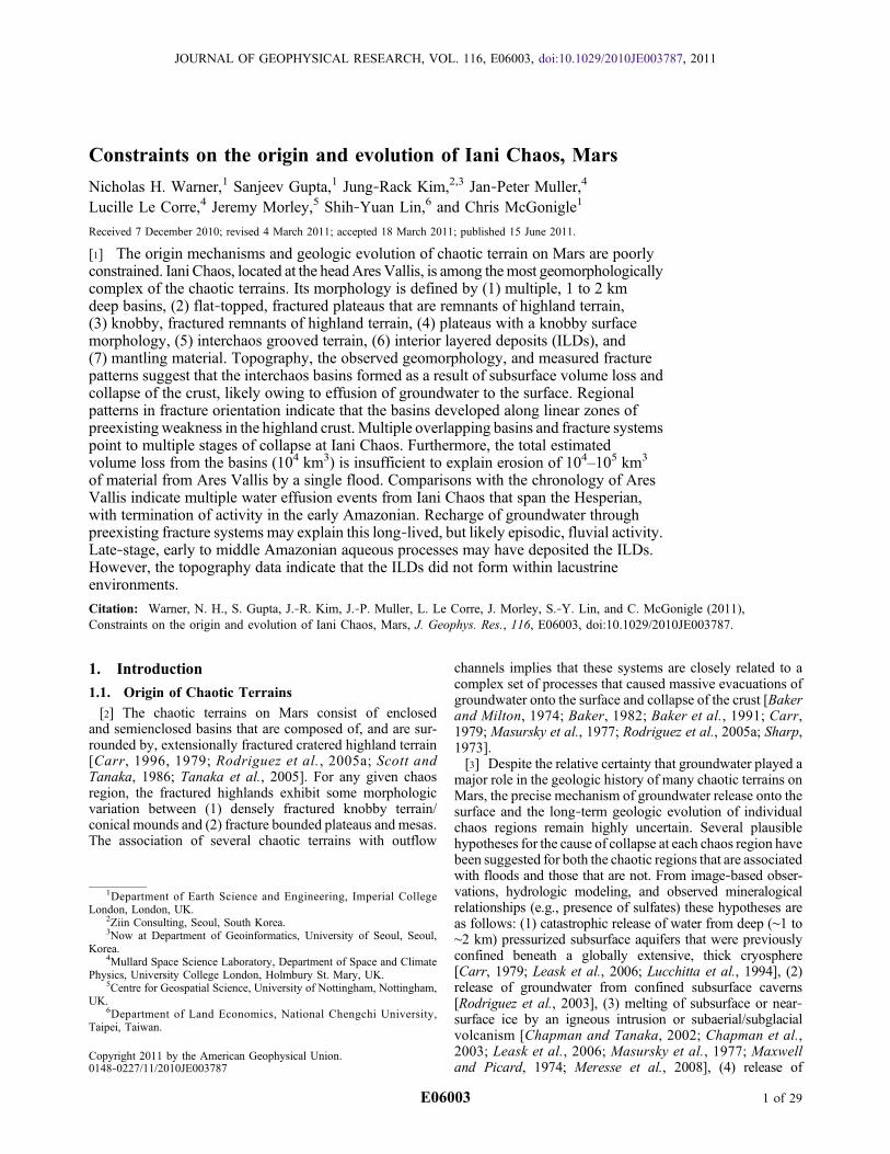
can explain the formation of all chaotic terrains. Variationin the geomorphology of different chaos regions impliesthat different formation mechanisms may have operated. Asan example, putative volcanic landforms that may suggestcryospheric melting and collapse are associated with somechaotic terrains, such as Hydraotes Chaos [Meresse et al.,2008], but are lacking in other regions, like Aram Chaos[Glotch and Christensen, 2005]. In addition, chaotic terrainslike Aromatum Chaos show evidence for only a single col-lapse event [Leask et al., 2006], while others, includingAureum Chaos [Rodriguez et al., 2005a], contain multi-ple overlapping basins that may require multiple collapseepisodes.
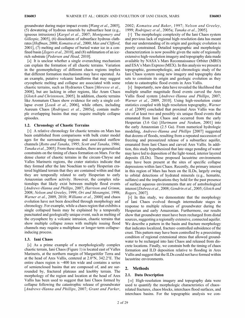
1.2. Chronology of Chaotic Terrains
[5] A relative chronology for chaotic terrains on Mars hasbeen established from comparisons with bulk crater modelages for the surrounding regions and associated outflowchannels [Rotto and Tanaka, 1995; Scott and Tanaka, 1986;Tanaka et al., 2005]. From these studies, there are generalizedconstraints on the timing of chaos formation on Mars. For thedense cluster of chaotic terrains in the circum‐Chryse andValles Marineris regions, the crater statistics indicate thatthey formed after the late Noachian to early Hesperian cra-tered highland terrain that they are contained within and thatthey are temporally related to early Hesperian to earlyAmazonian outflow activity. However, the complex rela-tionships that likely exist between multiple flood events[Andrews‐Hanna and Phillips, 2007; Harrison and Grimm,2008; Nelson and Greeley, 1999; Ori and Mosangini, 1998;Warner et al., 2009, 2010; Williams et al., 2000] and chaosevolution have not been described through morphology andchronology. For example, while a chaos region that exhibits asingle collapsed basin may be explained by a temporallypunctuated and geologically unique event, such as melting ofthe cryosphere by a volcanic intrusion, chaotic terrains thatshow multiple collapse zones with multiple issuing floodchannels may require a multiphase or longer‐term collapse‐inducing process.
1.3. Iani Chaos
[6] As a prime example of a morphologically complexchaotic terrain, Iani Chaos (Figure 1) is located east of VallesMarineris, at the northern margin of Margaritifer Terra andat the head of Ares Vallis, centered at 2.0°N, 342.2°E. Theentire chaos region is ∼400 km wide and contains a seriesof semienclosed basins that are composed of, and are sur-rounded by, fractured plateaus and knobby terrain. Themorphology of the region and location at the head of AresVallis has been used to suggest that Iani Chaos formed bycollapse following the catastrophic release of groundwater[Andrews‐Hanna and Phillips, 2007; Grant and Parker,
2002; Komatsu and Baker, 1997; Nelson and Greeley,1999; Rodriguez et al., 2005a; Tanaka et al., 2005].[7] The morphologic complexity of the Iani Chaos system
and previous lack of regional high‐resolution data has meantthat our understanding of its origin and geologic evolution ispoorly constrained. Detailed topographic and morphologiccharacterization is now possible given the suite of regionallyextensive high‐resolution imagery and topography data madeavailable by NASA’s Mars Reconnaissance Orbiter (MRO)and ESA’sMars Express (MEX). In this analysis we present atopographic, geomorphologic, and chronologic study of theIani Chaos system using new imagery and topography datasets to constrain its origin and geologic evolution as theyrelate to catastrophic flood events in Ares Vallis.[8] Importantly, new data have revealed the likelihood that
multiple smaller magnitude flood events carved the AresVallis flood system [Andrews‐Hanna and Phillips, 2007;Warner et al., 2009, 2010]. Using high‐resolution craterstatistics coupled with high‐resolution topography, Warneret al. [2009] concluded that proximal Ares Vallis was thesite of at least two and possibly six unique flood events thatemanated from Iani Chaos and occurred from the earlyHesperian (3.6 Ga) [Hartmann and Neukum, 2001] intothe early Amazonian (2.5 Ga). From numerical hydrologicmodeling, Andrews‐Hanna and Phillips [2007] suggestedthat dozens of floods, resulting from a repeated succession offreezing and pressurized release of a subsurface aquifer,emanated from Iani Chaos and carved Ares Vallis. In addi-tion, this study hypothesized that late‐stage ponding of watermay have led to deposition of the light‐toned, interior layereddeposits (ILDs). These proposed lacustrine environmentsmay have been present at the sites of specific collapsedepressions within Iani Chaos. Recently, the primary interestin this region of Mars has been on the ILDs, largely owingto orbital detections of hydrated minerals (e.g., hematite,sulfates) and the implications they hold for the past presenceof surface aqueous environments that are of astrobiologicalinterest [Dobrea et al., 2008;Gendrin et al., 2005;Glotch andRogers, 2007].[9] In this study, we demonstrate that the morphology
of Iani Chaos evolved through intermediate stages inresponse to multiple releases of groundwater during theHesperian and early Amazonian. Furthermore, our resultsshow that groundwater must have been recharged from distalsources, suggesting a regionally extensive, connected aquifer.We describe a pattern in the basin and fracture morphologythat indicates localized, fracture‐controlled subsidence of thecrust. This pattern may have been controlled by a preexistingcondition of regional extensional stress that allowed ground-water to be recharged into Iani Chaos and released from dis-crete locations. Finally, we constrain both the timing of chaosformation and ILD deposition relative to flooding in AresVallis and suggest that the ILDs could not have formedwithinlacustrine environments.
2. Methods
2.1. Data Description
[10] High‐resolution imagery and topography data wereused to quantify the morphologic characteristics of chaos‐related fractures, chaos blocks, interchaos flood surfaces, andinterchaos basins. For the topographic analysis we con-
WARNER ET AL.: ORIGIN AND EVOLUTION OF IANI CHAOS, MARS E06003E06003
2 of 29

structed a regional MEX High‐Resolution Stereo Camera(HRSC) digital terrain model (DTM) with 40 m grid spacingby mosaicing six HRSC DTM orbital strips. The DTM con-struction methods developed at University College Londonhave been previously described by Kim and Muller [2009]and Warner et al. [2009]. We also generated a near‐complete georeferenced and map‐projected MRO ContextCamera (CTX) mosaic at 6 m pixel−1 of the chaos region toanalyze the regional geomorphology. Specific geomorphicsurfaces were mapped from the CTX mosaic (including theILDs) to determine relative and absolute chronology byimpact crater statistics. HRSC orthoimages (15 m pixel−1)and the CTX mosaic were overlain on the digital terrainmodels to directly relate surface features to topography.Where available, MRO High‐Resolution Imaging ScienceExperiment (HiRISE) images at 25 cm pixel−1 were obtainedto highlight the stratigraphic characteristics of chaos blocksand the ILDs.
2.2. Impact Crater Chronology
[11] Previous crater counts from the highland terrains thatsurround Iani Chaos and Ares Vallis were acquired fromViking Orbiter and Mars Orbiter Camera (MOC) imagesusing craters with diameters (D) > 2 km or D > 5 km[Marchenko et al., 1998; Nelson and Greeley, 1999; Rottoand Tanaka, 1995; Scott and Tanaka, 1986; Tanaka andSkinner, 2004]. Crater model ages for the highlands suggesta late Noachian to early Hesperian (Hartmann and Neukum[2001] production function system, 4.0 Ga to 3.7 Ga) for-mation age. The timing of flood resurfacing in Ares Vallis hasmore recently been dated to the early Hesperian to earlyAmazonian periods (3.6 Ga to 2.5 Ga) [Warner et al., 2009,2010]. To improve upon these previous crater statisticsstudies we conducted high‐resolution crater counting (D >50 m for the ILDs, D > 100 m) and used absolute datingtechniques established by Hartmann and Neukum [2001] toestimate the crater retention age of the prechaos highland
Figure 1. HRSC DTM (40 m) overlain by a 15 m HRSC orthoimage displaying the Iani Chaos region onMars. The interchaos basins (B1–B8) and important morphologic features (e.g., highland plateaus, knobbyplateaus, and conical mounds) are highlighted. Interior layered deposits (ILDs) are displayed in white.
WARNER ET AL.: ORIGIN AND EVOLUTION OF IANI CHAOS, MARS E06003E06003
3 of 29

terrain surrounding Iani Chaos, proposed sedimentary infilldeposits (including the ILDs and mantling deposits), craterinfill material, and interchaos flood surfaces.[12] Counts were obtained from full‐resolution CTX mo-
saics (6 m pixel−1) using the Mars Editing and Assessmenttoolset [Simpson et al., 2008]. This Visual Basic® applicationallows craters to be tagged and measured on an imagebackdrop, while saving relevant diameter and location data toan ESRI® shape file. The freeware program Craterstats wasused to plot the crater statistics and to fit isochrons (witherror) to estimate absolute ages [Michael and Neukum, 2008].Crater statistics are presented here in table form as craterdensities for N(0.05) (ILDs only), N(0.1), N(0.5), N(1), N(5)(where N represents the cumulative number of craters coun-ted per 106 km2) and on log10 cumulative frequency plots thatutilize the production functions of Ivanov [2001] and chro-nology functions developed by Hartmann and Neukum[2001]. Wherever applicable, resurfacing corrections weremade following Michael and Neukum [2010].
3. Observations and Results
3.1. Geomorphology of Iani Chaos
[13] Figure 1 displays the 15 m pixel−1 HRSC imagemosaic overlain on the 40 m HRSC DTM. Using these high‐resolution regional data sets, we have classified Iani Chaosinto general morphologic zones that we refer to throughoutthe analysis. These zones are delineated on the basis ofcharacteristics of topography, relative chronology, fracturedensity, block morphology, and presence of geomorphicfeatures that suggest water flow (e.g., flood grooves, chan-nels, and streamlined remnants) and include (1) irregular,semicircular, or quasi‐linear basins (B1–B8) (Figure 1),(2) fractured remnants of cratered highland terrain composedof horizontally layered bedrock, capped by a single, smoothresistant capping unit (highland plateaus), (3) fracturedknobby terrain composed of isolated conical mounds that lacka resistant capping unit and contain subhorizontally layeredbedrock, (4) fractured plateaus of cratered highland terraincomposed of horizontally layered bedrock, exhibiting aknobby surface morphology (knobby plateaus), (5) groovedterrain that occurs between and issues from isolated topo-graphic depressions, (6) ILDs that overlie fractures and chaosblocks and occur in isolated patches within or at the edge ofthe basins (Figure 1), and (7) mantling material that occursthroughout and beyond the spatial extent of Iani Chaos.
3.1.1. Interchaos Basins[14] Figure 1 outlines the eight large (15 km to 120 km
wide) basins (B1–B8) that form interconnected and isolatedtopographic lows throughout Iani Chaos. These basins weredelineated on the basis of differences in total depth, planformmorphology, orientation, and relative relationships to AresVallis flood terrain (where applicable). Table 1 highlightsimportant morphometric and topographic characteristics ofeach basin. Below we provide a brief description of eachbasin.[15] Basin 1 (B1) is the largest single basin within Iani
Chaos. Located immediately south, and adjacent to thetopographically lowest flood channel in Ares Vallis [Warneret al., 2009], B1 can be best described as a semicircular ringbasin, containing a densely fractured, central topographic risethat is composed of smooth, flat‐topped blocks that are tens ofkilometers wide and are on average 2 km high relative to theminimum elevation of the floor of the basin. The maxi-mum elevation of the blocks that comprise the central high is−2230 m and is comparable to the elevation of the non-fractured highland terrain at the northwest margin of IaniChaos (−2200 m) (Figure 2a). Interior layered materials(ILDs) are present in discrete patches in the north, east, andsouthwest portions of the basin (section 3.1.6) (Figure 1).[16] Basin 2 (B2) is located east of B1 and heads the eastern
branch of Ares Vallis [Warner et al., 2009] (Figure 1). B2is a semicircular ring basin that contains a fractured centralhigh at ∼1.7 km above the floor of the basin. The maximumelevation of the central high, at −2700 m, is comparableto cratered highland terrain located east of Iani Chaos(Figure 2b).[17] Basins 3 and 4 (B3 and B4) are shallow depressions
located along the northwest margin of Iani Chaos (Figure 1).Both depressions contain hundreds of 100 m scale conicalmounds (Figure 2c). B3 is at its deepest ∼600 m deep. To thesouth, B3 is crosscut by the topographically lower andyounger interchaos basin, B5. B4 is separated from B3 by a6 km wide block of nonfractured cratered highland terrain.B4 has a maximum depth of ∼400 m. Located both adjacentto B3 and several kilometers west of B4, we have identifiedtwo unique grooved surfaces that are associated with shallowchaos depressions that are examples of interchaos flood ter-rain (see section 3.1.5) (Figure 3).[18] Basin 5 (B5) is a quasi‐linear topographic depression
(east‐northeast strike) located west of B1 (Figure 1). It has amaximum depth of ∼1.5 km (Figure 2d). B5 is bounded to thenorth by shallow chaotic terrains associated with B3 and B4
Table 1. Measured Volume and Depths for Individual Basins in Iani Chaos Measured From the 40 m HRSC DTM
Chaos Basin Sum of Difference From TINa (km) Grid Areab (km2) Max Depth (km) Mean Depth (km) Volume (km3)
B1 3804081 0.0016 1.9 0.7 6087B2 686441 0.0016 1.3 0.4 1098B3 92259 0.0016 0.6 0.2 148B4 16384 0.0016 0.4 0.2 26B5 931777 0.0016 1.5 0.4 1491B6 1708856 0.0016 1.5 0.3 2734B7 2064412 0.0016 1.1 0.3 3303B8 605826 0.0016 1.5 0.3 969Total 15856
aTIN, Triangulated Irregular Network.bSingle cell size equals 0.040 km.
WARNER ET AL.: ORIGIN AND EVOLUTION OF IANI CHAOS, MARS E06003E06003
4 of 29

and to the south by fractured plateaus of highland terrain(Figure 3). The largest (2 km wide) fractures run parallelto B5 and may be related to the formation and linear mor-phology of this basin. Unlike B1–B4, this basin is not locatedimmediately adjacent to flood‐grooved terrain.
[19] Basin 6 (B6) is composed of a series of irregular,interconnected topographic lows that mark the center ofIani Chaos (Figure 1). B6 is bounded by densely fracturedcratered highland material and contains numerous isolatedconical and plateau remnants. On average, the floor of B6 is
Figure 2. Topographic profiles derived from the 40 m HRSC DTM displaying the relative heights of theinterchaos basins to the surrounding highland terrain. The basins are between 400 m and 2 km deep, relativeto the highland terrain. The fractured plateaus that both border and are contained within some of the inter-chaos basins have an equivalent elevation to the surrounding nonfractured highlands.
WARNER ET AL.: ORIGIN AND EVOLUTION OF IANI CHAOS, MARS E06003E06003
5 of 29

significantly higher than B1, B2, and B5. This may in part bedue to the presence of ILDs that cover a significant portion ofthe basin’s floor (section 3.1.6). At its deepest point, B6 has afloor elevation of −4500 m, ∼1.5 km below the surroundinghighland terrain.[20] Basin 7 (B7) comprises a series of interconnected
basins in eastern Iani Chaos (Figure 1). B7 has a maximumdepth of ∼1.1 km. The lowest point of B7 corresponds with acircular topographic depression that may represent an ancient∼40 km wide impact crater. Within both the crater and theinterconnected topographic depressions, B7 contains a numberof densely fractured conical remnants, with discontinuousexposures of overlapping ILDs.[21] Basin 8 (B8) represents the southernmost basin of Iani
Chaos (Figure 1). B8 is a quasi‐linear topographic depressionwith a general northeast strike. Similar to B5, several largefractures strike parallel to this basin. At its deepest point B8 is∼1.5 km deep (Figure 2e). There is no evidence within thebasin, or adjacent to the basin, of flood eroded terrain (e.g.,channels, streamlined remnants, and grooved terrain). Thenorthern portion of B8 contains a thick, mounded outcrop ofILDs (section 3.1.6).3.1.2. Basin Volume Estimates[22] The topographic analysis suggests that the maximum
elevation of the nonfractured highland terrain that bounds theeastern, western, and southern margins of Iani Chaos iscomparable to the maximum elevation of many of the rem-nant fractured blocks that surround, andmost importantly, arescattered at several locations within the centers of the eight
interchaos basins (Figures 1 and 2). This observation suggeststhat the highland terrain was once continuous, with no majordeviation in topography across the widths of the basins. AsidefromB7, which may contain a large preexisting impact crater,the prominence and abundance of topographic highs withinthe basins negates the possibility that large topographicdepressions (e.g., impact craters) were present at the locationsof the eight basins before chaos formation. The interchaosdepressions therefore represent regions of significant volumeloss within theMartian crust. Below, we calculate the volumeof the interchaos depressions to estimate the total volume lossof material in Iani Chaos and to compare these values tovolume estimates of individual flood events within AresVallis.[23] To calculate volume, we digitized the topographically
irregular margins of each basin in ArcGIS, assigned an ele-vation value to each rim data point (3D point layer) from theHRSC DTM, and constructed a Triangulated Irregular Net-work (TIN) across the basin to represent the original, pre-chaos surface. The TIN was then converted to a 40 m griddedraster, from which the elevation values of the base HRSCDTM were subtracted to obtain the volume.[24] Table 1 provides the results of the volume calculation
for each basin. Figure 4 highlights the basin depth char-acteristics. It is noted that the HRSC DTM does not cover theentire extent of B5 and B8, but cuts each feature roughlyin half. Furthermore, many of the basins are partially filledwith sediments (ILDs) and/or mantles that superimposethe basin‐floor topography. While our analysis of the ILDs
Figure 3. CTX mosaics displaying flood‐grooved terrain (black arrows) on the northwest margin of IaniChaos. The topography and groove orientations suggest eastward flow from small, shallow chaos basinstoward Ares Vallis. (a) CTX images P04_002773_1784_XN_01S018W and P02_001995_1794_XN_00S018W illustrating grooved terrain east of B3. The northern rim of B5 truncates the grooves associatedwith this flooding event. (b) CTX images P15_006953_1767_XN_03S019W andB07_012504_1770_XN_03S020W displaying the grooved terrain to the west of B4. The southern margin of this flood surface is alsocrosscut by the younger basin B5.
WARNER ET AL.: ORIGIN AND EVOLUTION OF IANI CHAOS, MARS E06003E06003
6 of 29
(section 3.1.6) indicates that they may be relatively thin, wesuggest that our estimates of volume loss from these basinsare minimum values. The summed total volume of all thebasins in Iani Chaos is 1.6 × 10⁴ km3.
3.1.3. Chaos Block Morphology[25] The size and morphology of individual blocks and the
density of block fields within chaotic terrains are likelydirectly correlative with the size, orientation, and spacing ofextensional fractures [Rodriguez et al., 2005a]. Andrews‐Hanna and Phillips [2007] proposed that the regions ofhigh block density in chaotic terrains were areas wherehydrofracturing and water release generated numerous, closelyspaced fractures, whileRodriguez et al. [2005a] proposed thatthe large plateau remnants, with low fracture density, repre-sent regions of regional extension and limited subsidence.[26] Figure 5 highlights the variety of block morphologies
within Iani Chaos. In the highland marginal regions, large,kilometer‐scale fracture systems create isolated plateaus thatare up to ∼60 km in diameter and have relief of up to ∼2 km,measured from the floors of the bounding fractures (Figures 1and 5a). These large plateaus contain exposures of layeredbedrock and are often capped by a significantly thick (tensof meters) horizontally layered unit that is correlative acrossisolated plateaus andwith the undisturbed highlands over tensof kilometers (Figure 5a).[27] On the floors of the interchaos basins and super-
imposed on larger plateau remnants, are small conicalmounds (Figures 5b and 5c). These features range in widthfrom ∼100 m to ∼10 km and in height from tens of meters to∼1 km. In some regions, small conical mounds superimposethe fracture‐bounded plateau remnants forming knobbyplateaus (Figures 1 and 5c). This characteristic of overlappingblock morphologies is restricted to the central and easternregions of Iani Chaos (Figure 1). The maximum elevationof the mounds on the knobby plateaus is comparable to theelevation of the flat‐topped fractured plateaus in western IaniChaos and to the bordering, nonfractured highland terrain(Figure 1). The consistent defining characteristic of all thesmaller conical forms is the lack of a resistant capping unit.The slopes of the mounds typically range between 20° and
Figure 4. Depth map of the eight interchaos basins (B1–B8)displayed on the 40 m HRSC DTM. Basin volume (Table 1)was calculated by summing the calculated depths for eachgrid and multiplying that value by the grid area (1600 m2).The total calculated volume of the Iani Chaos basins is 1.6 ×10⁴ km3.
Figure 5. CTX images displaying different chaos block morphologies including (a) fractured plateaus(P15_006953_1767_XN_03S019W), (b) small conical mounds (P22_009603_1778_XN_02S018W andP04_002773_1784_XN_01S018W), and (c) plateaus superimposed by small conical mounds (knobbyplateaus) (P02_001995_1794_XN_00S018W).
WARNER ET AL.: ORIGIN AND EVOLUTION OF IANI CHAOS, MARS E06003E06003
7 of 29

30°, near the angle of repose. Where the flanks of the moundsare exposed, an internal layered stratigraphy that is similar inscale and lateral continuity to the layers exposed within thefractured plateaus and the surrounding nonfractured highlandterrain is visible (Figure 6).[28] Rodriguez et al. [2005a] indicated from observational
image analysis that subsidence and extensional fracturing ofthe highland terrain in Aureum Chaos only resulted in limitedwarping/tilting of the fractured highland plateaus. Here wequantify the tilt orientation and magnitude of the remnants ofhighland material in Iani Chaos, including both remnantplateau blocks and smaller conical mounds, to attempt toidentify patterns in the warping/tilting of chaos blocks. Bythis method, the location, magnitude, and mechanism ofsubsidence and extensional warping of the highland terrainwere constrained.[29] For this analysis, we usedArcGIS and the HRSCDTM
to measure both the slope angle and aspect (azimuth indegrees) of the upper surface of flat‐topped plateaus in IaniChaos to determine if the blocks underwent measurablerotation toward specific chaos depressions. We assume thatthe plateaus had an originally horizontal surface slope, con-trolled by the horizontal capping unit that is apparent onthe surface of all the blocks measured for the aspect analysis(A–I) (Figures 5 and 7). For each plateau block, we identifiedany significant deviation from the magnitude and directionof the slopes as they compare to typical values of the sur-rounding, nonfractured highland terrain. This method assumesthat secondary modification (erosion or deposition) of theupper surface has not smoothed the terrain on a regional scale,masking the primary tilt relationships of the blocks. This
assumption is validated by (1) the lateral continuity of thehorizontal capping unit acrossmultiple blocks, (2) the verticalcontinuity in the horizontally layered strata in the blocks, and(3) our slope aspect map (Figure 7), which reveals steepinterior plateau slopes (up to 50°) beneath the cappingunit. These steep slopes indicate limited postformation ero-sional modification of the fractured margins of the plateaus.Regional surface slopes, measured across the nonfracturedmarginal highland terrain from individual MOLA transects,range between 0.01° and 3°, depending on the location anddistance range (order of 100 km and 10 km, respectively) ofthe slope measurement.[30] Figure 7 presents two example regional slope aspect
maps for Iani Chaos derived from the HRSCDTM, regriddedto 1 km for ease in visualization and aspect computation. Fora selected plateau (A–I), we calculated the average aspect andthe average magnitude of the slope. Specific blocks that arelocated proximal to interchaos basins B1, B5, and B8 werechosen to reveal if the blocks tilted or warped in response tobasin formation. The results indicate that all plateaus have aconsistent average surface slope of 2.5° to 4°, similar to theupper range of slopes calculated for the nonfractured high-land terrain. Some measured plateaus that are proximal to thelinear chaos basins B5 and B8 show a consistent slope aspectthat suggests tilt toward the basins. As an example, themeasured grids on plateau A provide a statistically consistentpattern of surface tilt to the northeast, toward the interchaosbasin B5. The average slope of Block A is however low andsimilar to the upper bound slope of nonfractured highlandterrain (∼3°). The topographic profiles in Figures 2d and 2ealso display basinward sloping surfaces for the plateaus
Figure 6. High‐resolution images (CTX and High‐Resolution Imaging Science Experiment, HiRISE) ofsmall conical mounds within Iani Chaos. Subhorizontal to horizontal, meter‐scale layering is visible alongthe flanks of mounds (white arrows). The pattern of layering and thickness of individual layers is generallyconsistent with layers exposed along the fractured highland plateaus and within the nonfractured highlandterrain. (a) CTX image P13_006175_1774_XN_02S017W of layered stratigraphy in a small mound insouthern B1. (b) CTX image P04_002562_1795_XN_00S017W of layers exposed in a conical mound innorthern B1. (c) HiRISE image ESP_012728_1795_RED of layered, medium‐ to dark‐toned layers in amound in B1.
WARNER ET AL.: ORIGIN AND EVOLUTION OF IANI CHAOS, MARS E06003E06003
8 of 29

surrounding B5 and B8. This result may indicate limitedsubsidence (up to 300m) beneath these plateaus and block tilttoward the interchaos basin. The majority of blocks distal tothe collapse basins show an apparent random slope aspect.[31] For smaller conical mounds that lack a smooth capping
unit, the surface slope aspect cannot be calculated. Analysisof high‐resolution CTX and HiRISE images revealed that themajority of small conical mounds have an internal layeredstratigraphy that, upon initial examination, is similar in bed-ding thickness and dip to layered exposures in the surroundinghighland terrain and remnant plateaus (Figures 6 and 8). Usingthe ArcGIS extension LayerTools [Kneissl et al., 2010], weestimated the strike and dip of layers exposed within smallconical mounds that are on the floors of interchaos basins. Wehypothesized that the dip angles of the layers in these basin‐floor mounds might show significant tilting of the blocks,caused by undermining and collapse. For comparison, dipestimates were repeated for layers exposed in the remnantplateaus.[32] Layer contacts were identified at several locations on
the fracture‐bounded flanks of the plateau remnants. Layercontacts are sparse along the flanks of the smaller conicalmounds. In many places, talus and/or mantling material
obscure the flank exposures, particularly for the smallest(<1 km diameter) mounds. The results of the dip analysis forthe small conical mounds are therefore limited, both owing tothe lack of outcrops and the limited traceable extent of a singleunit. The measurements for the mounds indicate dips of 2° to9° (Figures 8a–8c), only slightly greater on average than thedip of the layers within the plateaus (1° to 3°) (Figure 8d).Furthermore, the measured layer dips for the plateaus aregenerally equal to the measured surface slopes. This validatesthat the surface slopes of the plateaus are reflective of theinternal layered stratigraphy and that the aspect measure-ments taken from the upper surface of the plateaus reflect thetilt of the entire block. Consistent with the slope aspectresults, from the LayerTools method we were unable toidentify evidence for significant warping or tilting of the largeplateau remnants. For the small mounds that occur withininterchaos basins, the larger dip estimates for the exposedlayers may be suggestive of block tilting during collapse,albeit limited to within 9° from horizontal.3.1.4. Fracture Morphology[33] Characteristic of all chaotic terrains, extension of the
crust around interchaos basins has created complex polygonalfracture networks that extend into the undisturbed cratered
Figure 7. Slope aspect map displayed over the 40 m HRSC DTM. Each arrow illustrates the magnitudeand direction of the average slope calculated from a 1 km size grid. Specific chaos blocks are highlighted todetermine if the blocks show evidence for tilt toward the basins B5, B6, and B8. The results demonstrate thatonly some of the blocks that are most proximal to the basins show a consistent pattern in surface aspect.These blocks are tilted, with a surface slope (�) of ∼2.5°–4° toward the interiors of the basins. Blocks locateddistal to the basins show an apparent random surface aspect (n equals the number of measurements).
WARNER ET AL.: ORIGIN AND EVOLUTION OF IANI CHAOS, MARS E06003E06003
9 of 29

highlands. To the first order, the fractures in these networksexhibit an apparent random orientation. However, it hasbeen proposed that global extensional stress fields may havefacilitated local groundwater release at specific locations onMars and influenced regional patterns in the formation ofchaos basins [Dohm et al., 2001; Komatsu et al., 2004;Lucchitta et al., 1994; Rodriguez et al., 2005a]. Given thishypothesis, if the extensional fracturing associated with chaosformation is influenced by regional and global structuralregimes, nonrandom patterns in the orientation of chaosfractures should be present.
[34] For this analysis we mapped the location and orien-tation of fractures within Iani Chaos to constrain the regional,paleostress field and to identify patterns relative to theinterchaos basins. As for all chaotic terrains on Mars, frac-tures within Iani Chaos are extensional. Individual fractureshave steep interior slopes (up to 50°), flat floors (filled withtalus), and are characterized by a linear, curvilinear, or pit‐chain planform morphology. Figure 9 illustrates examplesof the digitized fractures overlain on the CTX mosaic. Intotal, approximately 15,000 fracture segments were measuredacross the CTX strips. The fractures range inwidth from a few
Figure 8. Select CTX images of chaos blocks and plateaus illustrating the strike and dip characteristics ofthe internal stratigraphy. (a) CTX image P02_001995_1794_XN_00S018Wof shallow dipping (∼2°) layersin a small mound in B1. (b) CTX image P22_009603_1778_XN_02S018W of a small conical mound in B6.Layers in this mound show a dip of ∼7°. (c) CTX image P04_002773_1784_XN_01S018W showing layerswithin a small chaos mound in B6. Layers in this mound have a dip of ∼9°. (d) CTX image P15_006953_1767_XN_03S019W of near‐horizontal layers exposed on the flanks of a fractured plateau remnant of thehighland terrain.
WARNER ET AL.: ORIGIN AND EVOLUTION OF IANI CHAOS, MARS E06003E06003
10 of 29

meters to ∼3 km, in depth from a few meters to ∼2 km, and inspacing (measured across the largest width of a chaos block)from a few hundred meters to ∼60 km. The general polygonalpattern of fracturing in Iani Chaos is independent of the scaleand density of the fractures. However, in some regions, largefractures and pit chains follow parallel to the orientation ofquasi‐linear basins, such as for B5 and B8.[35] From the fracture measurements, we have identified
unique zones that have a consistent similarity in fracturedensity and scale in Iani Chaos. Importantly, these zonesexhibit multiple overlapping, nonrandom fracture patternsand correspond with specific geomorphologic features, suchas interchaos basins and smooth highland plateaus (Figure 9).Spatial associations have been identified that suggest a rela-tionship between fracture morphology, orientation, and basinlocation. Specifically, most of the fracture zones, regardlessof fracture scale, exhibit an average orientation that is con-sistent with the strike of associated basins (e.g., B5 and B8).The bordering nonfractured highland terrain grades intofractured plateaus of equal elevation that are surrounded bykilometer‐scale fractures with a low fracture density. In thisregion, the fracture patterns also suggest a consistent align-ment to nearby basins. In Zone 7 (Figure 9g), as well as inother regions of central, southern, and eastern Iani Chaos,large fracture systems crosscut densely fractured terrains.
This relationship has resulted in a superposition of knobbyterrain on large, isolated chaos plateaus. Several otherexamples of overlapping fracture systems are common andare obvious in the CTX imagery (Figure 10). The consistentrelationship observed in the imagery is the crosscutting ofsmaller and shallower fracture sets by larger fracture systems.3.1.5. Interchaos Flood Surfaces and Ares Vallis[36] Figure 3 identifies interchaos flood surfaces along the
northwest margin of Iani Chaos. They are identified by theoccurrence of subparallel grooves that emanate directly frominterchaos basins, including B3.We interpret these grooves tobe the result of erosion by macroturbulence (e.g., roller vor-tices) in a flood [Baker and Nummedal, 1978] on the basis oftheir subparallel alignment to the local slope (directed towardAres Vallis) and their morphologic similarity to previouslydescribed flood‐grooved terrain throughout the circum‐Chryse region [Baker, 1982; Baker and Kochel, 1979; Carr,1979; Komatsu and Baker, 1997; Nelson and Greeley, 1999;Scott and Tanaka, 1986; Tanaka et al., 2005; Tanaka, 1997].[37] Figure 3a is a CTX image of the grooved terrain
associated with interchaos basin B3. Figure 3b identifies thegrooved terrain west of B4. The grooves are 100 m wide andare regularly spaced by 100 m to 200 m. For the grooves inthe vicinity of B3, multiple surfaces with different grooveorientations are observed. To the northeast of B3, grooves
Figure 9. Montage of CTX mosaics in Iani Chaos displaying measured fracture patterns. Each map illus-trates the digitized fractures and the orientations of the fractures on rose diagrams. The fracture orientationsin Iani Chaos are not random. For several fracture zones, the fractures are aligned parallel to the orientationof linear chaos basins. This is particularly evident for Figures 9a–9c, 9e, and 9g (n equals the number ofmeasurements).
WARNER ET AL.: ORIGIN AND EVOLUTION OF IANI CHAOS, MARS E06003E06003
11 of 29

with a northeast‐southwest strike emanate from an oval, flat‐floored depression. Further to the northeast, grooves with aperpendicular northwest‐southeast strike are present. Thesouthern margin of this groove set is truncated by the steep(up to 50°) northern scarp of B5 (Figures 2 and 3), suggestingthat formation of the scarp wall (and thus B5) postdates for-mation of the grooves.[38] The best defined flood eroded surfaces associated with
Iani Chaos are the grooved terrains and flood channels ofproximal Ares Vallis. These flood terrains emanate northfrom B1 and B2. Utilizing a 50 m HRSC DTM and impactcrater chronology, Warner et al. [2009] mapped six distinctflood surfaces in proximal Ares Vallis. Here, using theimproved 40 m HRSC DTM (Figure 11), we present a sum-mary of this work, illustrating the location and elevation ofthese surfaces in the region proximal to Iani Chaos. Below,we describe the topographic relationships of northern IaniChaos relative to the Ares Vallis flood terrain, with emphasison the contact relationships between specific interchaosbasins and grooved surfaces.[39] The largest basin in Iani Chaos, B1, occurs at the head
of the deepest and youngest (early Amazonian) (Table 2)[Warner et al., 2009, 2010] outflow channel in Ares Vallis,Surface 6 (S6) (Figures 11a and 11b). At the northern marginof B1, S6 is 700m higher than the floor of B1, with an averageelevation of −4100 m. Along the east and west margins of B1,a topographically higher flood surface that bounds S6 ispresent. This surface, mapped as S5 is ∼1 km higher than thefloor of B1, with an average floor elevation of −3560 m(Figure 11a). Importantly, all grooves and smooth surfacesassociated with S5 and S6 are truncated by the northernmargin of B1 (Figures 11b and 11c). This suggests that theformation of this interchaos basin postdates the youngest,early Amazonian catastrophic flood events in Ares Vallis.
Furthermore, there are no flood grooves, streamlined rem-nants, or channels within B1 that might be suggestive ofpost–basin formation catastrophic flooding.[40] East of B1, B2 occurs at the head of the eastern
branch of Ares Vallis, mapped as S4 byWarner et al. [2009](Figures 11a and 11c). S4, carved in the early Hesperian,represents an early stage of catastrophic flood activity in AresVallis. The average elevation of S4, along the northernmargin of B2 is −3310 m. The surface is perched ∼900 mabove the floor of B2. Bounding the western margin of B2,an ∼8 km remnant strip of S5 separates the basin from B1(Figure 11c). Importantly, the grooved terrains and channelremnants of both S4 and S5 are truncated by B2, suggestingthat basin formation occurred after flooding on both surfaces.Furthermore, similar to B1, no channels, streamlined rem-nants, or grooved terrains were identified on the floor of B2.[41] From CTX and HRSC image analysis, flood eroded
terrain was not identified adjacent to the basins that occur inthe interior of Iani Chaos, B5–B8. Rather, all preservedgrooved terrains were identified along the northern marginsof the chaos system. Flood eroded surfaces associated withthe northwest highlandmargin of Iani Chaos (Figures 2 and 3)represent a previously undescribed source of flooding thatmay be directly related to events and features in the mainchannels of Ares Vallis. The groove orientations on thesesurfaces are consistent with water flow away from shallowchaos depressions and toward Ares Vallis (Figures 3 and11a). From HRSC topography data, the average elevation ofthe distal extent (northeast edge) of the B3 grooved terrainis −2700 m (Figures 1 and 3). The grooved surface at thislocation is truncated by perpendicularly oriented floodchannels that are associated with S5 and S6 (Figure 11a).Topographically, the B3 grooved terrain is perched ∼1.5 kmabove S6. By comparison to other flood surfaces in Ares
Figure 10. CTX images displaying overlapping patterns of fracture density and orientation in Iani Chaos:(a) CTX image P08_003973_1772_XN_02S019W of overlapping fracture patterns on large plateaus inwestern Iani Chaos and (b) CTX image P02_001995_1794_XN_00S018W of a dense set of fractures thatare crosscut by larger fractures in central Iani Chaos.
WARNER ET AL.: ORIGIN AND EVOLUTION OF IANI CHAOS, MARS E06003E06003
12 of 29
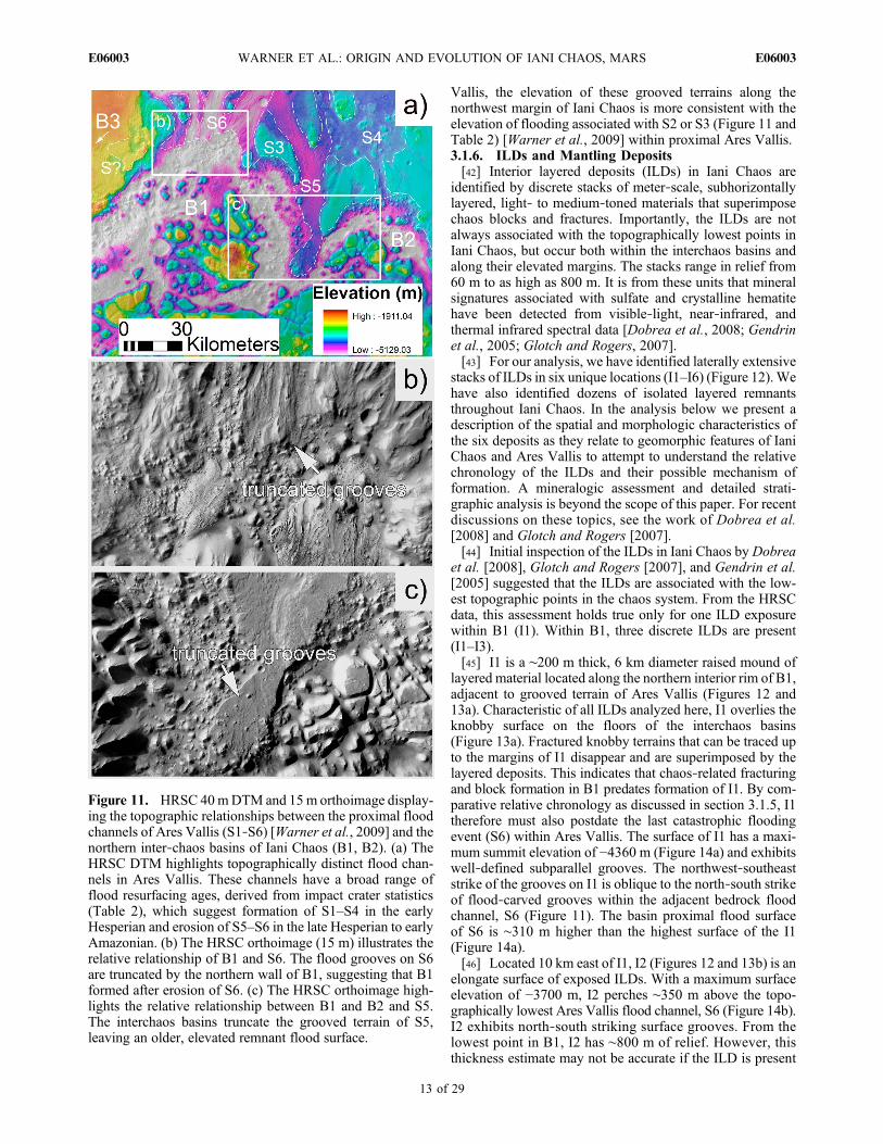
Vallis, the elevation of these grooved terrains along thenorthwest margin of Iani Chaos is more consistent with theelevation of flooding associated with S2 or S3 (Figure 11 andTable 2) [Warner et al., 2009] within proximal Ares Vallis.3.1.6. ILDs and Mantling Deposits[42] Interior layered deposits (ILDs) in Iani Chaos are
identified by discrete stacks of meter‐scale, subhorizontallylayered, light‐ to medium‐toned materials that superimposechaos blocks and fractures. Importantly, the ILDs are notalways associated with the topographically lowest points inIani Chaos, but occur both within the interchaos basins andalong their elevated margins. The stacks range in relief from60 m to as high as 800 m. It is from these units that mineralsignatures associated with sulfate and crystalline hematitehave been detected from visible‐light, near‐infrared, andthermal infrared spectral data [Dobrea et al., 2008; Gendrinet al., 2005; Glotch and Rogers, 2007].[43] For our analysis, we have identified laterally extensive
stacks of ILDs in six unique locations (I1–I6) (Figure 12).Wehave also identified dozens of isolated layered remnantsthroughout Iani Chaos. In the analysis below we present adescription of the spatial and morphologic characteristics ofthe six deposits as they relate to geomorphic features of IaniChaos and Ares Vallis to attempt to understand the relativechronology of the ILDs and their possible mechanism offormation. A mineralogic assessment and detailed strati-graphic analysis is beyond the scope of this paper. For recentdiscussions on these topics, see the work of Dobrea et al.[2008] and Glotch and Rogers [2007].[44] Initial inspection of the ILDs in Iani Chaos by Dobrea
et al. [2008], Glotch and Rogers [2007], and Gendrin et al.[2005] suggested that the ILDs are associated with the low-est topographic points in the chaos system. From the HRSCdata, this assessment holds true only for one ILD exposurewithin B1 (I1). Within B1, three discrete ILDs are present(I1–I3).[45] I1 is a ∼200 m thick, 6 km diameter raised mound of
layered material located along the northern interior rim of B1,adjacent to grooved terrain of Ares Vallis (Figures 12 and13a). Characteristic of all ILDs analyzed here, I1 overlies theknobby surface on the floors of the interchaos basins(Figure 13a). Fractured knobby terrains that can be traced upto the margins of I1 disappear and are superimposed by thelayered deposits. This indicates that chaos‐related fracturingand block formation in B1 predates formation of I1. By com-parative relative chronology as discussed in section 3.1.5, I1therefore must also postdate the last catastrophic floodingevent (S6) within Ares Vallis. The surface of I1 has a maxi-mum summit elevation of −4360 m (Figure 14a) and exhibitswell‐defined subparallel grooves. The northwest‐southeaststrike of the grooves on I1 is oblique to the north‐south strikeof flood‐carved grooves within the adjacent bedrock floodchannel, S6 (Figure 11). The basin proximal flood surfaceof S6 is ∼310 m higher than the highest surface of the I1(Figure 14a).[46] Located 10 km east of I1, I2 (Figures 12 and 13b) is an
elongate surface of exposed ILDs. With a maximum surfaceelevation of −3700 m, I2 perches ∼350 m above the topo-graphically lowest Ares Vallis flood channel, S6 (Figure 14b).I2 exhibits north‐south striking surface grooves. From thelowest point in B1, I2 has ∼800 m of relief. However, thisthickness estimate may not be accurate if the ILD is present
Figure 11. HRSC 40mDTM and 15m orthoimage display-ing the topographic relationships between the proximal floodchannels of Ares Vallis (S1‐S6) [Warner et al., 2009] and thenorthern inter‐chaos basins of Iani Chaos (B1, B2). (a) TheHRSC DTM highlights topographically distinct flood chan-nels in Ares Vallis. These channels have a broad range offlood resurfacing ages, derived from impact crater statistics(Table 2), which suggest formation of S1–S4 in the earlyHesperian and erosion of S5–S6 in the late Hesperian to earlyAmazonian. (b) The HRSC orthoimage (15 m) illustrates therelative relationship of B1 and S6. The flood grooves on S6are truncated by the northern wall of B1, suggesting that B1formed after erosion of S6. (c) The HRSC orthoimage high-lights the relative relationship between B1 and B2 and S5.The interchaos basins truncate the grooved terrain of S5,leaving an older, elevated remnant flood surface.
WARNER ET AL.: ORIGIN AND EVOLUTION OF IANI CHAOS, MARS E06003E06003
13 of 29

only as a thin veneer on an underlying topographic high. Three‐dimensional HRSC perspective views reveal onlappingcharacteristics between layers of I2 and a nonlayered conicalmound (layers in the mound may be obscured by talus)(Figure 15a).[47] I3 is a 45 km long, 18 kmwide mounded ILD exposure
located immediately within the western margin of B1(Figures 12 and 13c). Figure 14c provides a northwest‐southeast topographic profile taken perpendicular to the strikeof the mound. The summit elevation of I3 is −3630 m,approximately 420 m higher than S6 in Ares Vallis, and∼300 m lower than S4. Measured from the bottom of themound to the summit, the mound has ∼700 m of relief.However, perspective views of I3 reveal onlapping relation-ships between conical mounds of remnant highland materialand the layered deposits (Figure 15b). Similar to I2, thissuggests that I3 may be thinner than its total relief impliesas it may drape preexisting elevated topography. The uppersurface of the ILD mound is grooved, showing a northwest‐southeast groove orientation that is oblique to grooves on I2,but consistent with the groove orientation on I1. However,local variations in groove orientation are obvious (Figure 13c),particularly around the conical mounds and margins of thedeposit where grooves are perpendicular or oblique to thegeneral northwest pattern.[48] I4, located near the center of Iani Chaos (Figures 12
and 13d), represents an aerially extensive ILD that exhibitsobvious meter‐scale horizontally layered stratigraphy ofalternating light and medium‐toned material. The averageelevation, taken across the surface of I4, is −3400 m(Figure 14d), approximately 650 m higher than the chaos‐proximal elevation of S6. Similar to other ILDs in Iani Chaos,fractures truncate abruptly against I4. This also suggests thatdeposition of the layered materials postdates fracturing and
mound formation. Unique to the previously described ILDs,I4 shows no evidence for surface grooving. Rather, thedeposit is either laterally continuous, with a smooth surface,or has been degraded into small remnant layered mounds
Figure 12. HRSC orthomosaic (15 m) of Iani Chaos dis-playing the locations of the six interior layered deposits(I1–I6) discussed in this analysis. Transects A–F are alsodrawn on the image. The topographic profiles from thesetransects are displayed in Figure 14.
Table 2. Impact Crater Statistics for Iani Chaos and Ares Vallisa
SurfacesArea(km2) Counts N(0.05) N(0.1) N(0.5) N(1) N(5) Model Age From Fit (Ga) Relative Age
This Study (Iani Chaos)Fractured plateaus 30474 23149 NA 7.6 × 10⁵ 2.0 × 10⁴ 4.7 × 10³ 6.9 × 10² 3.08b (+0.07, −0.10);
3.90 (+0.03, −0.04)LHb,c, EAb,d;MNc, MNd
Floor‐fractured crater 693 899 NA 1.3 × 10⁶ 1.6 × 10⁴ 1.4 × 10³ NA 2.87 (+0.33, −0.56) LHc, EAd
Grooved terrain (west) 74 156 NA 2.1 × 10⁶ 1.4 × 10⁴ NA NA 2.87 (+0.24, −0.34) LHc, EAd
ILD north (I1, I2, I3) 882 170 1.9 × 10⁵ 5.3 × 10⁴ 1.1 × 10³ NA NA 0.02 (+0.003, −0.003) LAc, LAd
ILD central (I4) 3153 436 1.4 × 10⁵ 4.3 × 10⁴ 9.5 × 10² NA NA 0.10 (+0.03, −0.03) LAc, LAd
ILD east (I5) 62 24 3.9 × 10⁵ 8.1 × 10⁴ NA NA NA 0.04 (+0.01, −0.01) LAc, LAd
ILD south (I6) 408 44 1.1 × 10⁵ 4.2 × 10⁴ 4.9 × 10³ NA NA 0.02 (+0.005, −0.005) LAc, LAd
Mantling unit 333 399 NA 1.2 × 10⁶ 9.0 × 10³ NA NA 0.71 (+0.05, −0.05) MAc, MAd
From Warner et al. [2009] (Proximal Ares Vallis)S1 1164 1189 NA 1.0 × 10⁶ 1.7 × 10⁴ 3.4 × 10³ NA 3.60 (+0.07, −0.14) LNc, EHd
S2 525 59 NA NA 1.9 × 10⁴ 3.8 × 10³ NA 3.62 (+0.09, −0.27) LNc, EHd
S4 2243 1795 NA 8.0 × 10⁵ 1.3 × 10⁴ 3.6 × 10³ NA 3.62 (+0.08, −0.18) LNc, EHd
S5 1149 115 NA NA 9.6 × 10³ 1.7 × 10³ NA 2.53 (+0.81, −1.80) EAc, EAd
S6 5735 3078 NA 5.4 × 10⁵ 9.9 × 10³ 1.7 × 10³ NA 2.86 (+0.39, −0.76) LHc, EAd
From Warner et al. [2010] (Proximal‐Distal Ares Vallis)S6 21720 13781 NA 6.3 × 10⁵ 1.4 × 10⁴ 2.5 × 10³ NA 2.54b (+0.13, −0.13),
3.73 (+0.04, −0.05)EAb,c, EAb,d;LNc, EHd
aStatistics for each surface are displayed as N(X), where N is the cumulative number of craters counted on a surface per 106 km2 and X is the given diameterrange in kilometers. Absolute model ages are derived from crater production and chronology functions presented by Ivanov [2001] andHartmann andNeukum[2001]. NA, data not available; E, early; M, middle; L, late; N, Noachian; H, Hesperian; A, Amazonian.
bResurfacing correction.cHartmann age system.dNeukum age system.
WARNER ET AL.: ORIGIN AND EVOLUTION OF IANI CHAOS, MARS E06003E06003
14 of 29
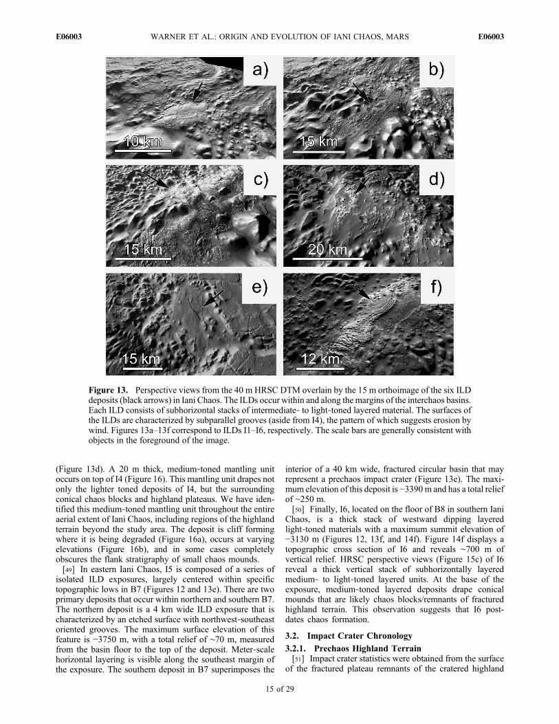
(Figure 13d). A 20 m thick, medium‐toned mantling unitoccurs on top of I4 (Figure 16). This mantling unit drapes notonly the lighter toned deposits of I4, but the surroundingconical chaos blocks and highland plateaus. We have iden-tified this medium‐toned mantling unit throughout the entireaerial extent of Iani Chaos, including regions of the highlandterrain beyond the study area. The deposit is cliff formingwhere it is being degraded (Figure 16a), occurs at varyingelevations (Figure 16b), and in some cases completelyobscures the flank stratigraphy of small chaos mounds.[49] In eastern Iani Chaos, I5 is composed of a series of
isolated ILD exposures, largely centered within specifictopographic lows in B7 (Figures 12 and 13e). There are twoprimary deposits that occur within northern and southern B7.The northern deposit is a 4 km wide ILD exposure that ischaracterized by an etched surface with northwest‐southeastoriented grooves. The maximum surface elevation of thisfeature is −3750 m, with a total relief of ∼70 m, measuredfrom the basin floor to the top of the deposit. Meter‐scalehorizontal layering is visible along the southeast margin ofthe exposure. The southern deposit in B7 superimposes the
interior of a 40 km wide, fractured circular basin that mayrepresent a prechaos impact crater (Figure 13e). The maxi-mum elevation of this deposit is −3390m and has a total reliefof ∼250 m.[50] Finally, I6, located on the floor of B8 in southern Iani
Chaos, is a thick stack of westward dipping layeredlight‐toned materials with a maximum summit elevation of−3130 m (Figures 12, 13f, and 14f). Figure 14f displays atopographic cross section of I6 and reveals ∼700 m ofvertical relief. HRSC perspective views (Figure 15c) of I6reveal a thick vertical stack of subhorizontally layeredmedium‐ to light‐toned layered units. At the base of theexposure, medium‐toned layered deposits drape conicalmounds that are likely chaos blocks/remnants of fracturedhighland terrain. This observation suggests that I6 post-dates chaos formation.
3.2. Impact Crater Chronology
3.2.1. Prechaos Highland Terrain[51] Impact crater statistics were obtained from the surface
of the fractured plateau remnants of the cratered highland
Figure 13. Perspective views from the 40 m HRSC DTM overlain by the 15 m orthoimage of the six ILDdeposits (black arrows) in Iani Chaos. The ILDs occur within and along the margins of the interchaos basins.Each ILD consists of subhorizontal stacks of intermediate‐ to light‐toned layered material. The surfaces ofthe ILDs are characterized by subparallel grooves (aside from I4), the pattern of which suggests erosion bywind. Figures 13a–13f correspond to ILDs I1–I6, respectively. The scale bars are generally consistent withobjects in the foreground of the image.
WARNER ET AL.: ORIGIN AND EVOLUTION OF IANI CHAOS, MARS E06003E06003
15 of 29

terrain, located along the western and eastern boundaries ofIani Chaos (Figure 17). The surfaces of the remnant plateausare characterized by a relatively smooth landscape that ismorphologically and topographically consistent with thehighland plains that surround Iani Chaos. Tanaka et al. [2005]mapped the highland terrain in this region as part of the early
to middle Noachian age Libya Montes unit from craters withD > 5 km.[52] Table 2 provides the crater statistics for all surfaces in
this study, including the Ares Vallis flood surfaces fromWarner et al. [2009, 2010] for comparison. For the remnantplateaus, over 23,000 impact craters with D > 100 m werecounted from the CTX mosaic over an area of ∼30,000 km2.
Figure 14. Topographic profiles of the ILDs in Iani Chaos, corresponding with transects across the ILDspresented in Figure 12. Each ILD consists of a mound of layered materials ranging from 60 to 800 m inheight, measured from the base of the associated interchaos basin. Transect B highlights the topographicrelationship between I2 and the topographically lowest flood surface of Ares Vallis, S6. Here, the uppersurface of I2 is ∼350 m higher than the nearby flood surface.
WARNER ET AL.: ORIGIN AND EVOLUTION OF IANI CHAOS, MARS E06003E06003
16 of 29

Figure 18a illustrates the cumulative frequency histogram forcounts taken from the plateaus. For craters with D > 2.6 km,the data closely follow the 3.9 Ga isochron indicating a modelformation age ofmiddle to late Noachian (Table 2), consistentwith the findings by Tanaka et al. [2005]. However, our datareveal a previously undescribed major deviation from the3.9 Ga isochron for D < 2.6 km. The slope of the cumulativefrequency curve between D = 700 m to 2.6 km declinesgradually until a fit is reestablished at 3.0 Ga for D = 200 mto 700 m, indicating a late Hesperian resurfacing event. At
diameters less than 200 m, the general rollover in the datamay be the result of either (1) preferential destruction of thesmallest crater population by dust infill or other erosive/burial processes or (2) human error in counting the smallest,most abundant crater population.3.2.2. Crater Modification and Fracture Age[53] The largest diameter craters (D > 8 km) within Iani
Chaos show varying states of preservation, with some cratersthat have distinct ejecta blankets and rims and some that lackejecta, have heavily modified rims, and contain significantinfill. The layered infill material in some modified impactbasins exhibit networks of polygonal fractures that some-times form chaos‐block morphology and often have interiorrim moats that are typical of other floor‐fractured craters(FFC) on Mars [Rodriguez et al., 2005a; Sato et al., 2010].FFCs on Mars are preferentially located near chaotic terrainsand outflow channels, including Iani Chaos and Ares Vallis,and are therefore likely related to the evacuation of water,subsurface volume loss, and extensional fracturing at theselocations.[54] Figure 19 identifies one particular FFC, located along
the southern margin of Iani Chaos at 5.5°S, 343.5°E. Thecrosscutting relationship of the crater floor materials to thefractures indicates that extensional fracturing of the FFCoccurred after the floor materials were emplaced. Figure 18bprovides the cumulative frequency histogram of craters withD > 100 m on the surface of the floor material. The data(Table 2) indicate a best fit to the 2.9 Ga isochron for the floorof material at D = 400 m to 1 km. At D < 400 m the curvedeviates significantly from the isochron indicating preferen-tial removal of the smaller craters. It should be noted that themodel age error for the floor of this crater (+0.3, −0.6 Ga)indicates substantial variability in the potential age offormation (Hesperian to early Amazonian). This error isdue to the small area of the analysis and limited number ofcraters (25) with diameters between 400 m and 1 km, fromwhich the fit was constructed. From this data set, extensionalfracturing of the floor material within the crater can beconstrained to a time during or after the Hesperian. Byassociation with adjacent fracture systems in Iani Chaos, thisloosely constrains the timing of fracturing in Iani Chaos tothis time period.3.2.3. Chronology of Associated Flood Surfaces[55] High‐resolution image analysis reveals interchaos
channel floors that are defined by regularly spaced longitu-dinal grooves. Two grooved floor remnants were identifiedwithin Iani Chaos, proximal to the shallow chaos basins onthe northwest margin of Iani Chaos (B3 and B4) (Figures 2and 3). Inferred flow direction from groove orientation sug-gests that flow occurred to the east, from discrete, shallowchaos depressions, toward proximal channels of Ares Vallis.The areas of these surfaces are small and the cumulative craterfrequency histograms reveal significant errors (maximumerror of +/−300Ma) in themodel ages (Figure 18c). However,the ages are consistent with the general Hesperian to earlyAmazonian timing of circum‐Chryse floods [Marchenkoet al., 1998; Nelson and Greeley, 1999; Rotto and Tanaka,1995; Tanaka and Skinner, 2004; Warner et al., 2009].[56] From the topography, the B3 and B4 grooved terrains
are not likely related to the topographically lowest andyoungest flood events in Ares Vallis, S5–S6 (Figure 11). Forthese surfaces to have formed as the result of a chronologi-
Figure 15. Perspective views of ILDs in Iani Chaos from theHRSC DTM: (a) layered materials within I2 drape a conicalmound on the floor of B1, (b) light‐toned layered materialswithin I3 embay against conical mounds within B5, and(c) layered materials within I6 cover small conical featureson the floor of B8. These observations suggest that the ILDsare younger than the interchaos basins that contain the smallconical mounds.
WARNER ET AL.: ORIGIN AND EVOLUTION OF IANI CHAOS, MARS E06003E06003
17 of 29

cally synchronous event, flooding from B3 and B4 wouldhave flowed over a substantial elevation drop of ∼1 km over ashort distance of only 30 km. There is however no evidencefor grooves, channels, or cataracts between these two surfacesthat would suggest continuous, time‐synchronous flow over alarge gradient. Rather, it is more likely that these topo-graphically high interchaos flood surfaces are related to theolder, topographically higher, early Hesperian age floodingevents in Ares Vallis, including S2–S4 (Table 2). We excludeS1 fromWarner et al. [2009] as a related surface because it istopographically higher at its downstream origin than the B3and B4 grooved terrain.3.2.4. Chronology of ILDs[57] Table 2 presents the crater count statistics for the most
regionally extensive ILDs in Iani Chaos. These include thenorthern ILD exposures in B1 (I1–I3) (Figure 18d), thecentral exposures within B6 (I4) (Figure 18e), the easternexposures in B7 (I5) (Figure 18f), and the southern exposuresin B8 (I6) (Figure 18g). Impact craters on these surfaces arepoorly preserved relative to craters on the highland plateausand basin floors (Figure 20). These features lack ejecta, arecommonly infilled with lower albedo material, and havesubdued rims that are superimposed by subparallel grooves.This morphology indicates that the ILDs do not easily pre-serve impact craters, and thus suggests that any model agederived from these features will not be representative of theirtrue formation age.[58] For the northern ILD surfaces (Figure 18d), the crater
cumulative frequency histogram indicates a steady decline
in slope for all diameter bins beneath D = 1.3 km (thelargest crater on the northern ILD surfaces = 1.3 km). A fitto the entire diameter range provides a model age of∼25 Ma (+3.2, −3.3), or late Amazonian relative age. For thecentral deposits, which have the largest aerial extent in IaniChaos (Table 2), a fit from D = 200 m – 500 m suggests a lateAmazonian model age of 100 Ma (+25, −26) (Figure 18e). Asharp decline in the cumulative frequency curve occurs onthis surface at D < 200 m, indicating preferential removal ofthe smallest diameter craters. For the eastern deposit, thecrater statistics indicate a fit to the late Amazonian, 44 Ma(+13, −13) isochron for craters with D = 50 m – 100 m(Figure 18f). Finally, for the series of ILDs in southern IaniChaos, a good fit to the 22 Ma (+5.3, −5.5) isochron isobvious for craters with D < 200m, with few craters availableat larger diameters (Figure 18g). In summary, all ILDs in IaniChaos have a late Amazonian crater retention age.
4. Discussion
4.1. Fracture‐Controlled Collapse Origin of Iani Chaos
[59] The fracture analysis (Figure 9) and topography data(Figure 2) provide important clues to the origin of Iani Chaos.Extensional fractures associated with chaos formation, on alocal (within individual basins) and regional scale (across IaniChaos), are not randomly oriented. Furthermore, the observedconsistency in the alignment of quasi‐linear basins (B5, B8)(Figure 1) and fracture systems indicates a genetic correlationbetween basin formation processes and extensional fracturing
Figure 16. CTX images highlighting example locations of the regionally extensive mantling unit in IaniChaos. (a) CTX image P02_001995_1794_XN_00S018W showing degradation of the mantling unit. Inmany places in Iani Chaos the mantle is scarp forming, suggesting that the material is well indurated.(b) CTX image P22_009603_1778_XN_02S018W illustrating the draping characteristic of the mantlingunit. In this image, the mantle occurs both at the base and on the upper surface of a 400 m tall scarp.(c) CTX image P02_001995_1794_00S018W displaying the medium‐toned mantling unit in centralIani Chaos. Here, within B6, the mantling unit overlies small conical mounds and light‐toned ILDsassociated with I4.
WARNER ET AL.: ORIGIN AND EVOLUTION OF IANI CHAOS, MARS E06003E06003
18 of 29

of the crust. From the topographic and stratigraphic obser-vations that indicate a previously continuous highland surfaceacross the interchaos basins (Figures 2 and 5a), we suggestthat the most likely mechanism for generating polygonalnetworks of extensional fractures in association with deepbasins is by collapse‐induced extension of the crust, a resultof undermining of the subsurface (volume loss). Volume lossfrom depth (1 km to 2 km) and collapse likely resulted inregional extension and formation of the kilometer‐scale(depth, width, and length) fracture sets.[60] The regional fracture analysis (Figure 9) revealed a
consistent variation in the orientation of fractures betweennorthern and southern Iani Chaos. For northern Iani Chaos,we identified a dominant ENE‐WSW directed fracture sys-tem that is aligned parallel to the general strike of B5 andsuggests maximumNNW‐SSE directed extensional stress. Inthe south, the dominant NNE‐SSW orientation of fracturesindicates a WNW‐ESE component of extension. These pat-terns, and their relationship to the orientations of interchaosbasins, are best explained if some preexisting condition ofextensional stress in the region influenced not only the
location of collapse events but also the alignments of theresultant extensional fractures. Furthermore, multiple direc-tional components of maximum extension were identified forspecific regions and may indicate multiple overlapping,preexisting extensional patterns and/or multiple basin for-mation events (Figures 9 and 10). For the large semicircularbasins (B1, B2, B6), fracture control is less obvious, however,these features occur at the locus of intersection of the quasi‐linear basins B5 and B8 and may thus represent a prechaoscondition of enhanced crustal weakness.[61] The slope aspect data provide further important clues
to the nature of collapse in Iani Chaos (Figure 7). As postu-lated by Rodriguez et al. [2005a], we hypothesized thatcollapse‐induced extension of the highland terrain withinIani Chaos may have caused warping/tilting of the basin‐bounding highland crust. However, the slope aspect analysis,topographic profiles (Figures 2 and 7), and LayerTools dipanalysis suggest that tilting of the plateaus and conicalmounds was limited, possibly only to regions that were mostproximal to the interchaos basins. From the topography data,the upper horizontal surfaces of some plateaus in westernIani Chaos are at an equal elevation to the surroundinghighland terrain, while others in northern, central, andeastern Iani Chaos occur only a few hundred meters belowthe highlands (Figures 1 and 2). These observations confirmthat significant collapse and subsurface volume loss did notoccur beneath the basin‐proximal plateaus and was restrictedto only specific zones in Iani Chaos that correspond with thelocations of the modern day, fracture‐controlled interchaosbasins.[62] Given the observation of grooved flood terrains (Ares
Vallis) that emanate from basins within Iani Chaos (B1–B4),we propose that volume loss within this region of the high-lands was caused by the evacuation of previously confinedgroundwater.We suggest that Iani Chaos formed by collapse‐induced extensional fracturing and basin formation over anaquifer that was pressurized beneath a thickened cryosphere[Carr, 1979;Coleman et al., 2007;Leask et al., 2006;Lucchittaet al., 1994]. As hypothesized for other circum‐Chrysechaotic terrains [Anderson et al., 2001; Dohm et al., 2001;Komatsu et al., 2004; Lucchitta et al., 1994; Rodriguezet al., 2005a], the directional component of the chaos‐related extensional fractures identified in northern andsouthern Iani Chaos may be consistent with the complexradial and concentric patterns of tectonic fracturing associ-ated with the long‐term evolution of the Tharsis bulge.There is some direct chronologic evidence to link the for-mation of global/regional fractures caused by the construc-tion of Tharsis and opening of Valles Marineris to theinitiation of flooding and groundwater release at Iani Chaos.Our absolute and relative chronology data indicate that basinformation in Iani Chaos likely occurred as early as theHesperian (B3 and B4) and as late as the early Amazonian(B1, B2, B5). The initial construction of Tharsis in theNoachian and the opening of Valles Marineris after the lateNoachian and into the Hesperian [Anderson et al., 2001;Anguita et al., 2006; Carr and Head, 2010; Nimmo andTanaka, 2005; Schultz, 1998; Tanaka et al., 1991; Werner,2009] likely occurred before, or at the very beginning of,the initial early Hesperian flooding activity in Ares Vallis[Warner et al., 2009, 2010]. Therefore, it is possible that
Figure 17. CTX mosaic displaying the impact crater counts(D > 100 m, except ILDs) for mapped surfaces in Iani Chaos,including the fractured plateaus, ILDs (D > 50 m), interchaosgrooved terrain, mantling unit, and crater floor infill for asingle floor‐fractured crater in southern Iani Chaos. Thestatistics from these counts are presented in Table 2. Thecumulative crater frequency histograms are presented inFigure 18.
WARNER ET AL.: ORIGIN AND EVOLUTION OF IANI CHAOS, MARS E06003E06003
19 of 29

Figure 18. Cumulative frequency histograms for impact craters in Iani Chaos. The model ages are derivedfrom specific surfaces that include (a) fractured highland plateaus, (b) infill within a floor‐fractured crater,(c) interchaos grooved terrain (flood eroded), (d) ILD exposures in northern Iani Chaos (I1–I3), (e) ILDs incentral Iani Chaos (I4), (f) ILDs in eastern Iani Chaos (I5), (g) ILDs in southern Iani Chaos (I6), and (h) themantling unit.
WARNER ET AL.: ORIGIN AND EVOLUTION OF IANI CHAOS, MARS E06003E06003
20 of 29

preexisting tectonic fractures, originating from a globalTharsis‐related stress field, may have facilitated the releaseof water at Iani Chaos, acting as a point of weakness orpermeable conduit through which pressurized subsurfacewater could escape.
4.2. Other Chaos Formation Hypotheses
[63] It has been proposed that impact crater floors may haverepresented initial zones of crustal weakness through whichsubsurface water could have gained access to the surface[Sato et al., 2010]. The image and topography data indicatethat the interchaos depressions, in most cases, do not exhibitdiagnostic impact basin morphologies (circular planformmorphology, raised rims, ejecta, conical central peaks). Infact, the largest semicircular basins (B1 and B2) containcentral topographic highs that are significantly broad (up to50 km in width), flat‐topped, and heavily cratered. Thesecharacteristics are inconsistent in relative scale and mor-phology with the conical central peaks of large impact craters(Figures 1 and 2). Aside from the few preserved fracturedfloor craters in Iani Chaos (Figures 17 and 19), there is noconfirming observational evidence that the largest chaosdepressions are collapsed remnants of these features. How-ever, it is unclear whether the fracture/basin alignments inIani Chaos were generated by the occurrence of preexistingfractures associated with large, Noachian age, buried impact
basins [Rodriguez et al., 2005b]. Fractures associated with thecrater containing Aram Chaos and with large crater basinssouth of Iani Chaos, including the Argyre, Ladon, andMargaritifer basins (among others) [Grant and Parker, 2002],may have had a control in generating a complex regionalextensional stress field (in conjunction with, or separatefrom the Tharsis‐related field) that facilitated water releaseat Iani Chaos. Similarly, from our observations we alsoreject the possibility that Iani Chaos and Ares Vallis formedfrom the release of pressurized, ice‐covered lakes that weresustained within preexisting impact craters or topographicdepressions [Zegers et al., 2010]. If preexisting depressionsexisted, they were likely small and did not dominate thepreexisting geomorphology of the region.[64] The occurrence of chaotic terrains on the floors of some
circum‐Chryse flood channels has been proposed as evidencethat flood erosion is capable of initiating chaos formation byremoving bedrock overburden from a pressurized aquifer[Coleman, 2005; Rodriguez et al., 2005a]. However, there isno evidence of flood grooving, channel systems, streamlinedfeatures, or other diagnostic indicators of catastrophic floodingon top of chaos blocks in Iani Chaos or within the interchaosbasins, aside from the small grooved terrains adjacent toB3 and B4. Furthermore, while it has been proposed that
Figure 19. CTX image B03_010671_1759_XN_04S016Whighlighting the craters on the floor of the infill materialwithin a floor‐fractured crater in southern Iani Chaos. Thefractures crosscut the infill material. The crater statistics indi-cate a late Hesperian to early Amazonian age for the infill.This constrains the age of this fracturing event to some pointafter this time, suggesting that extensional fracturing in IaniChaos may have occurred into the early Amazonian.
Figure 20. CTX image P04_002562_1795_XN_00S017Wshowing a 1 km size impact crater on the surface of an ILDdeposit in northern Iani Chaos (I2). The crater is highlydegraded and is superimposed by grooves that are likely asso-ciated with wind erosion. The morphology of the impact cra-ters and the presence of yardang‐like grooves on the ILDsindicate that the ILDs are easily eroded and likely semifriable.Crater statistics that are derived from the ILDs therefore canonly provide a crater retention age and not the true formationage of the deposits.
WARNER ET AL.: ORIGIN AND EVOLUTION OF IANI CHAOS, MARS E06003E06003
21 of 29

the Margaritifer flood system may have entered directlyinto the southern region of Iani Chaos before the formationof Ares Vallis [Grant and Parker, 2002], we have notobserved evidence in the high‐resolution imagery for floodgrooved terrain or channels that enter Iani. Rather, severalinterconnected chaos basins define the northern portion ofthe Margaritifer fluvial‐chaos system.[65] It remains unclear whether igneous processes caused
initial deformation and fracturing of the highland crust orpressurization of subsurface water in the Iani Chaos region.Regional mean slope measurements (Figure 7) do not revealevidence for regional deformation, such as doming, that mayhave been associated with upwelling magma. Furthermore,CTX imagery does not reveal conclusive evidence for surfacevolcanism or exhumed intrusive morphologies (e.g., dykes).While it is possible that regional intrusive processes may haveinitiated Iani Chaos, the frequency of flood activity withinAres Vallis [Warner et al., 2009, 2010] would have requiredintrusive igneous activity to have occurred on multipleoccasions throughout a period of ∼1 Ga. Furthermore, evi-dence for time‐synchronous flooding from Iani and HydapsisChaos (separated spatially by ∼500 km) [Warner et al., 2010]would have also required the circumstance of coincidentalindependent igneous activity that heated subsurface water ormelted subsurface ice deposits beneath two different chaoslocations. We therefore propose that the trigger mechanismfor flooding likely involved a long‐lived or episodic regionalprocess that is difficult (but not impossible) to explain by avolcanic mechanism that left no obvious surface expression.[66] Other origin hypotheses that include the release of
groundwater during major impact events [Wang et al., 2005],dissolution of subsurface hydrous clathrates [Hoffman, 2000;Komatsu et al., 2000; Max and Clifford, 2001], and subli-mation of an ice‐rich substrate [Pedersen and Head, 2010]are difficult to assess from morphology alone. The likelihoodthat sufficiently large impact events could have generatedsustained thermal energy to melt subsurface ice of sufficientvolumes to catastrophically and episodically erode AresVallis throughout a period of ∼1 Ga seems unlikely. Fur-thermore, if this hypothesis were correct, the impact event(s)did not leave obvious geomorphic markers. Figures 1 and 17reveal three and possibly four obvious prechaos craters in IaniChaos with D > 16 km (largest = 40 km) over an area of∼80,000 km2. Large impact events were extremely rareduring our proposed timing for chaos formation (Hesperianto early Amazonian) [Hartmann, 2005]. Late Hesperian agesurfaces on Mars collected only ∼10 impact craters withD > 16 km over an area of 106 km2 (N(16)). For earlyHesperian age surfaces, the N(16) value is ∼20.[67] Sublimation or dissolution of subsurface, hydrous
materials (e.g., ice, sulfates, and clathrates) may have resultedin regionally restricted collapse events as is observed in IaniChaos. Water that was derived from hydrous materials duringdissolution may have been released through preexistingweaknesses in the crust as we propose for the interchaosbasins. However, both the dissolution and sublimationhypotheses at Iani Chaos need to be reconciled with theassociation and catastrophic nature of flood channels and theimplication that floods in Ares Vallis occurred on multipleoccasions. It is also difficult to assess both the climatic con-ditions required to facilitate large‐scale sublimation of an ice
deposit beneath Iani Chaos or the chemical and stratigraphicrelationships that would be required to dissolve enoughhydrated minerals to release water of sufficient volume toerode Ares Vallis.
4.3. Multiple Collapse Episodes
[68] The minimum volume loss of material beneath IaniChaos is on the order of 104 km3, estimated from the HRSCDTM (Table 1). By comparison, Warner et al. [2009] iden-tified bedrock terraces and flood‐eroded trimlines withinAres Vallis that suggested water depths between 200 m and500 m for individual flood events. Using the total area ofthe bedrock‐eroded canyon system of Ares Vallis (∼1.1 ×10⁵ km2) and assuming an estimated flood depth of 200 m, arough, minimum total volume of material eroded by a singleflood event in Ares Vallis is 2.0 × 10⁴ km3. This volumeestimate excludes the distal region of Ares Vallis where theflood entered Chryse Planitia. In this region, volume isdifficult to calculate as down‐cutting was limited where theflood expanded. A total maximum volume for Ares Vallis,including the total depth of the channel systems is ∼105 km3.[69] While the erodibility of the Martian terrain at Ares
Vallis, flow viscosity, and flood sediment concentration areunknown, we suggest that the total volume loss within IaniChaos (104 km3) is insufficient to explain the erosion of AresVallis (104–105 km3) by a single, turbulent water flood,derived from an isolated aquifer of equivalent volume to thechaos depressions. Furthermore, it is unlikely that the totalvolume loss in Iani Chaos can be accounted for by release ofpure liquid water. Rather, some volume of material evacuatedfrom the interchaos basins may have been sediment and/orice. The total volume of water that was available from thebasins to do erosive work in Ares Vallis was therefore likelyless than the total estimated basin volumes. If floods of theequivalent volume to the interchaos basins carved AresVallis, then the sediment to water ratio (∼1:1) of the floodswould have beenmore similar to that of a viscous debris flow.On the basis of the geomorphology of putative flood depositsat the mouth of the circum‐Chryse outflow channels, Tanaka[1999] suggested that the channels might have been carved bysediment‐rich debris flows. However, by terrestrial analogy[Baker and Nummedal, 1978], the occurrence of longitudinalgrooves, knickpoints (cataracts), streamlined islands, andterraced flood surfaces within Ares Vallis [Warner et al.,2009] is more consistent with erosion by turbulent waterfloods. The channel‐source volume disparity thereforerequires the possibility that (1) water was recharged fromdistal sources into Iani Chaos and resulted in multiple floodevents into Ares Vallis and/or (2) tributaries, includingchannels from Aram and Hydapsis Chaos, contributed someunknown volume of water to the erosion of Ares Vallis.Estimates for the total volume of Aram Chaos (104 km3)[Zegers et al., 2010] and Hydapsis Chaos (104 km3) (ourestimate) are of the same order of magnitude to the IaniChaos basins. Taken together, and without a mechanism ofwater recharge, floods of this combined volume would stillbe characterized by a significantly high sediment to waterratio.[70] Uncertainties in the amount of water released from
tributaries to Ares Vallis make it difficult to assess whethertheir contribution alone could explain the erosion of Ares
WARNER ET AL.: ORIGIN AND EVOLUTION OF IANI CHAOS, MARS E06003E06003
22 of 29

Vallis. However, observations of multiple terraced surfaces inAres Vallis upstream of these tributaries indicate that multiplefloods likely issued directly from Iani Chaos [Warner et al.,2009]. Furthermore, from our fracture and chaos‐moundanalysis, we have identified evidence for multiple, overlappingfracture events and superimposing chaos‐mound morpholo-gies that are indicative of fracturing related to extensionalcollapse at different spatial scales at different times (Figures 9and 10). The occurrence of small conical mounds containedwithin shallow depressions, superimposed on the surfaces oflarger chaos plateaus, represents one example of overlappingchaos formation events (Figure 10). We suggest that thismorphology is best explained if older, shallow chaos depres-sions (similar in depth and morphology to B3 and B4) werelater fractured by younger, kilometer‐scale extensional fea-tures. By this model, the shallower depressions and conicalmound morphology formed from localized, shallow subsi-dence, while the larger fractures resulted from regionalextension that followed the formation of the deepest (up to2 km) interchaos basins (B1–B2, B5–B8).[71] In support of the multiple collapse hypothesis, we have
identified grooved terrains and shallow chaos basins (includ-ing B3 and B4) along the northwest margin of Iani Chaos thatare truncated by (and are therefore older than) the deeperbasins B1 and B5 (Figures 2 and 3 and Table 1). B3 and B4occur directly adjacent to flood terrain and we suggest thatsome of these shallow basins may represent the direct sourceof the small flood events. By comparison, B1, which destroysthe margins of the shallow basins, truncates the youngest,early Amazonian age Ares Vallis flood surface (S6, Table 2),suggesting that collapse of B1 was one of the last majorevents in the region. These relative relationships requiremultiple overlapping collapse events that are associated withmultiple, topographically distinct flood channels.
4.4. Hypotheses for Observed Basin and FractureChronology
[72] Assuming the model of cryosphere overpressurizationfor the initiation of flooding into Ares Vallis, the relativechronology of fracturing and basin formation events in IaniChaos may suggest a temporal control on the depth of col-lapse that was created by conditions within the cryosphere.We envision two possible scenarios for the observed cross-cutting fracture and basin relationships that indicate that thedeepest chaos basins are preceded by shallower collapseevents.[73] 1. Early‐stage (early Hesperian), shallow (200–500m)
collapse events involved only small volumes of water. Thiswater was sourced from a deep (∼2 km) aquifer that waspressurized by overburden of a thickened cryosphere. Theshallow collapse events occurred in the initial stage of cryo-sphere weakening/fracturing as water permeated throughfractures in the cryosphere. Shallow collapse by this mecha-nism may have occurred owing to local subsidence over theevacuated zone. Later events (Hesperian to early Amazonian)were more catastrophic, owing to further cracking of thecryosphere and opening of the aquifer to the surface. Multiplewater release events may have been facilitated by not onlyrecharge of groundwater into the system but refreezing of thefractures and aquifer repressurization [Andrews‐Hanna andPhillips, 2007; Hanna and Phillips, 2006; Wang et al., 2006].The younger water release events in this scenario tapped
larger volumes of water and thus caused deeper collapses andregional extension.[74] 2. Early‐stage (early Hesperian) shallow collapse
events resulted from the release of water from a shallowsubsurface water source, beneath a thin cryosphere (200 m–500 m). With time, progressive deepening of the cryosphereand water source led to overpressurization and deep‐seatedcollapse events, forming younger, 1 to 2 km deep collapsedepressions in the late Hesperian to early Amazonian.[75] The intriguing possibility of scenario 2 is that the
observed pattern of overlapping fractures and basins wasgenerated by cooling of the global climate from the earlyHesperian into the early Amazonian. This cooling wouldhave thickened the regionally extensive cryosphere beneathIani Chaos, causing the groundwater release events (floods)to tap a source that deepened with time. If this model iscorrect, chaos morphology may be a proxy for understandingthe evolution of the Hesperian hydro/cryosphere, with theimplication that the cryosphere thickened beneath Iani Chaosfrom 200 m to 2 km from the early Hesperian into the earlyAmazonian.
4.5. Distal Groundwater Recharge
[76] Given the source‐channel volume disparity, the chro-nology of the flood system, our observations for discretebasins, and the topographic evidence for limited subsidencebeneath the fractured highlands, we suggest that episodiceffusion of water into Ares Vallis was controlled by distalwater recharge that was not derived from local sources withinthe general region of Iani Chaos. While the water was likelyvertically confined beneath a cryosphere, it was directedlaterally through a regionally connected fracture‐controlledsubsurface aquifer system with episodic water release eventsoccurring at the sites of specific zones of crustal weakness. Bythis model, water release is spatially restricted to specificrelease points where multiple floods may have occurredfollowing cycles of repeated aquifer freezing and over-pressurization [Andrews‐Hanna and Phillips, 2007; Hannaand Phillips, 2006; Harrison and Grimm, 2008; Rodriguezet al., 2005a; Wang et al., 2006]. Because the fracturedhighlands that are adjacent to the collapse basins in IaniChaos show limited warping/tilting and exhibit equivalentelevation to the highland terrain, they may overlie a com-pletely intact, deep, frozen aquifer that was untapped byflooding events. Alternatively, the aquifer may have beencompartmentalized [Harrison and Grimm, 2009] and pres-ent only along specific regions of high crustal permeability(e.g., fracture systems). Northward and eastward directedsubsurface flow out of Iani Chaos is implied by the orien-tation of the chaos‐proximal flood channels. Recharge ofthis system may have been possible if the subsurface aquiferwas interconnected with distal aquifer systems associatedwith other chaotic terrains east of Vallis Marineris or withchaotic terrains and basins located south of Iani Chaos,including Margaritifer Chaos and Ladon Basin [Grant andParker, 2002].
4.6. Relationship of ILD Formation to the ChaosTerrain
[77] From observed onlapping relationships of the ILDswith chaos blocks in THEMIS‐VIS images,Glotch and Rogers[2007] and Dobrea et al. [2008] suggested that ILD deposi-
WARNER ET AL.: ORIGIN AND EVOLUTION OF IANI CHAOS, MARS E06003E06003
23 of 29

tion generally occurred after formation of the chaotic terrain.These observations are consistent with the results of ouranalysis, obtained from higher resolution CTX images andHRSC‐derived topography data (Figures 13–15). On thebasis of relative associations with previous crater count sta-tistics of the Ares Vallis region [Rotto and Tanaka, 1995;Tanaka et al., 2003], Glotch and Rogers [2007] suggested ascenario that the sulfate and hematite‐bearing ILDs thatoverly the chaotic terrain formed in the Hesperian, after and/or during catastrophic flooding in Ares Vallis. These authorsproposed that multiple smaller floods, derived from IaniChaos, may have resulted in the formation of playa lake en-vironments within isolated, semienclosed basins, correlatingwith the basins B1–B8. Model‐based predictions of late‐stage, low‐magnitude floods from Iani Chaos have been usedto suggest that ponding may have occurred within preexisting
collapse depressions where sulfate‐hematite mineralizationoccurred in an evaporative lake environment [Andrews‐Hanna and Phillips, 2007].[78] Our updated chronology data and topographic obser-
vations presented in this analysis enable us to (1) constrain thetiming of ILD formation in Iani Chaos and (2) test thehypothesis that the ILDs were deposited within lacustrineenvironments that were generated after the chaos basins wereformed. The crater statistics for the ILDs (Figures 18d–18g)suggest a late Amazonian crater‐retention age. This result issimilar to the crater statistics study presented by Rossi et al.[2008], who supplied a late Amazonian crater retention ageof 0.3 Ma for a limited area of the Iani Chaos ILDs, includingthe deposits in the northern and southern regions of the cha-otic terrain. From image observations, the surfaces of most ofthe ILDs are grooved and show poor crater preservation withsuperposition of the grooves on the rims of the current craterpopulation (Figures 13, 15, and 20). This suggests thatgrooving of the ILDs is likely the result of a recent, lateAmazonian process. The pattern of surface grooving isclearly not consistent with erosion by floods, as the grooveorientations are variable and do not typically show a consis-tent orientation relative to local slope and flooding in AresVallis. Furthermore, chaos blocks that surround the ILDs lacka streamlined morphology that would suggest significanterosion by water (Figure 15). Rather, the grooved morphol-ogy on all ILD surfaces is likely the result of relatively recentwind erosion, with local variations in orientation caused bydiversion of winds around complex topography. By thismechanism, the grooves are yardangs that formed within asemifriable material.[79] The late Amazonian model age for the ILDs is either
(1) a crater retention age that represents the time since thesurface of the ILDs has become stable enough to allow for theestablishment of a crater population or (2) an exhumation agethat indicates the time since the ILDs have been exposed tocratering. Our image analysis reveals a regionally extensivemantling unit across Iani Chaos (Figure 16). This mantlingunit overlies and embays chaos mounds and fractures, occursat variable elevations, and has been eroded in places to formscarps that expose underlying light‐toned ILDs (Figures 13dand 16c). From crater statistics collected from a continuouspatch of the mantling unit in northern Iani Chaos, we haveobtained a middle Amazonian model age (Figure 18h). It istherefore likely that the ILDs within Iani Chaos predate themantling unit and that their youthful crater model age mayrepresent the time since exhumation from beneath the man-tling unit.[80] From CTX image observations it is clear that all the
major ILD outcrops (I1–I6) rest on top of chaos mounds andsuperimpose both large and small fracture systems (Figures 13and 15). This indicates that the ILDs were deposited afterIani Chaos was fully developed, after basins B1–B8 wereformed. From crosscutting relationships between the floodgrooves of the proximal channels in Ares Vallis and theinterior walls of B1–B2 (Figure 11), we suggest that thesebasins (containing I1–I3) formed after the final flood ero-sional event in Ares Vallis. Using the crater statisticalanalysis presented by Warner et al. [2009, 2010] (Table 2),and these relative associations, we can constrain the timingof formation for the ILDs in B1 and B2 to sometime in the
Figure 21. Perspective HRSC views of northern Iani Chaosdisplaying important topographic relationships of the ILDsand the flood channels of Ares Vallis. (a) The mean elevationof the proximal surface of S6 (youngest Ares Vallis floodchannel) is approximately −4100 m. This image displaysthe −4100 m contour across the northwestern region of B1.The upper surface of I2 rests approximately 350 m abovethe −4100 m contour. This suggests that any water surface(a lake) that was contained within this contour was not of suf-ficient elevation to account for deposition of the upper surfaceof I2. (b) Along the western margin of B1, I3 rests approxi-mately 400 m above the −4100 m contour. This also suggeststhat water confined behind S6 could not account for deposi-tion of the upper surface of I3.
WARNER ET AL.: ORIGIN AND EVOLUTION OF IANI CHAOS, MARS E06003E06003
24 of 29

Amazonian, after the early Amazonian flood events thatformed the topographically lowest channels of Ares Vallis.For the ILDs in B5–B8, we lack relative chronologicinformation because there is no direct contact between floodchannels of Ares Vallis and the basin walls. However,because many of these deposits underlie the regionallyextensive mantling unit, they likely formed at some timeafter chaos formation and before the middle Amazonian.[81] From the topographic observations presented in
section 3.1.6 (Figure 14) we have determined that not all theanalyzed ILD outcrops correspond with the topographicallylowest regions in Iani Chaos.Most importantly, aside from I1,the upper surfaces of all the major ILDs (I2–I6) are topo-graphically higher than the lowest flood channels of AresVallis (S5, S6). In the case of I2, which occurs only a fewkilometers south of the proximal reach of S6, its upper surfacelies ∼350 m above the floor of the flood channel (Figures 2band 21a). From this simple topographic observation, and theobservation that I2 must have formed after B1 and thus afterthe proximal flood channels of Ares Vallis, we suggest that itis impossible for I2 to have formed by sedimentary depositionor evaporative accumulation within a standing body of waterwithin B1. Given the relative chronology, we suggest that atthe time of deposition of layered units in I2, there was notopographic boundary high enough that could have supportedthe formation of an equipotential lake surface within B1 toallow for deposition of the uppermost layered unit of the ILDmound. Similarly, the highest layered unit exposed within I3is ∼420 m higher than the proximal channels of Ares Vallis(Figure 21b). For I4–I6, topographic barriers are lackingwhere preexisting large fracture systems crosscut the sur-rounding basin walls. In order for standing water to havecovered the topographically highest ILD (I4), water wouldhave also inundated most of the interchaos fractures anddepressions that predate formation of I4. This would havegenerated a massive interchaos lake system; however, we donot observe any geomorphologic or topographic indicatorsof a regionally extensive lake.[82] Our results require an alternative formation mecha-
nism to the lacustrine basin hypothesis for the ILDs in IaniChaos. Recently, Rossi et al. [2008] presented a scenario forthe Amazonian age deposition of the ILDs in Iani Chaos asspring deposits. By this model, upwelling acidic waters,flowing through preexisting chaos fractures, depositedmound‐like, sulfate‐bearing layered units. Our analysis in-dicates that this scenario may be more plausible for the IaniChaos ILDs than the lacustrine hypothesis. However, theorigin of this Amazonian age water reservoir is unclear. In analternative model, air fall deposition by aeolian or volcanicprocesses may have generated regionally extensive, terrain‐blanketing stacks of horizontally layered materials that werelater altered by aqueous processes and partially eroded bywind, removing evidence of these deposits on upper surfacesof the chaotic terrains. The air fall deposition model howeverdoes not account for the fact that some of the topographicallylowest, confined regions in Iani Chaos, which are possibly theareas that are protected by wind erosion, do not contain evi-dence for ILD deposition. The exact origin mechanism for theILDs in Iani Chaos remains unresolved and requires higherresolution analysis (e.g., HiRISE images and DTMs) toidentify lateral and vertical patterns in the stratigraphy of thedeposits that might identify a specific process.
4.7. Summary of Geologic History of Iani Chaos
[83] Figure 22 provides a schematic summary that illus-trates our proposed relative and absolute sequence of eventsfor the formation of Iani Chaos as it relates to collapse events,fracturing, and flooding within Ares Vallis. The schematichighlights the uncertainties about the depth of the subsurfaceaquifer/cryosphere during the long‐term evolution of IaniChaos. Either a constant depth aquifer model or progressiveaquifer deepening model can explain the observed featuresin Iani Chaos if the volume of individual water effusionevents is adjusted to account for shallow collapses with thedeep aquifer model. Below, we highlight some of the majorevents that formed Iani Chaos and describe importantinterpretations.[84] 1. The first event in this region is identified in the crater
statistics from the nonfractured highland terrain that sur-rounds Iani Chaos. Deposition of the horizontally layeredunits that comprise the surface of the highland terrain and thefractured plateaus occurred in the late Noachian, near 3.9 Ga(Table 2).[85] 2. Crater statistics from the topographically highest,
shallow flood surfaces in Ares Vallis reveal a flood resurfa-cing age of ∼3.6 Ga [Warner et al., 2009]. This suggests thatevacuation of water from the Iani Chaos region may havebegun as soon as the early Hesperian. Shallow collapsedepressions (e.g., B3 and B4) and densely fractured moundsthat superimpose larger fractured plateaus may represent thesource of these earliest floods.[86] 3. The shape of the cumulative frequency curve in
Figure 18a indicates a resurfacing event on the highlands andon the fractured plateaus during the Hesperian, at ∼3.0 Ga.The origin of this resurfacing is enigmatic. It is unclear fromthis data set whether fracturing within Iani Chaos occurredbefore, during, or after the resurfacing, as the process ofresurfacing may have additionally affected the interiors of thefractures. This would particularly be relevant if top‐downerosion or burial (air fall) removed craters across the entireregion.[87] 4. A limited set of crater statistics identified a late
Hesperian age flood event (∼3.0 Ga) on the small groovedterrains associated with B3 andB4 on the northwest margin ofIani Chaos. On the basis of crosscutting relationships, boththe flood surfaces and the basins formed before B1 and B5and before the topographically lowest flood channels of AresVallis (S5, S6).[88] 5. Impact crater statistics taken from the topographi-
cally lowest flood channels in Ares Vallis (S5, S6) indicate aearly Amazonian flood resurfacing age of ∼2.5 Ga – 2.9 Ga[Warner et al., 2009, 2010]. These surfaces represent the lastmajor flood erosional activity within Ares Vallis.[89] 6. The northern rims of B1 and B2 truncate flood
grooves and smooth surfaces associated with S5 and S6. Thisindicates that these large interchaos basins, in their currentform, formed at some time after the early Amazonian(<2.5 Ga – 2.9 Ga).[90] 7. ILDs throughout Iani Chaos rest unconformably on
top of chaos mounds suggesting that they formed after IaniChaos was fully developed. From relative relationships withthe youngest Ares Vallis flood channels, the ILDs in B1 andB2must have formed at some point after the early Amazonian(<2.5 Ga – 2.9 Ga).
WARNER ET AL.: ORIGIN AND EVOLUTION OF IANI CHAOS, MARS E06003E06003
25 of 29
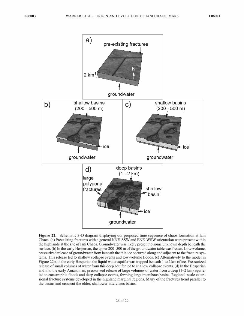
Figure 22. Schematic 3‐D diagram displaying our proposed time sequence of chaos formation at IaniChaos. (a) Preexisting fractures with a general NNE‐SSW and ENE‐WSW orientation were present withinthe highlands at the site of Iani Chaos. Groundwater was likely present to some unknown depth beneath thesurface. (b) In the early Hesperian, the upper 200–500m of the groundwater table was frozen. Low‐volume,pressurized release of groundwater from beneath the thin ice occurred along and adjacent to the fracture sys-tems. This release led to shallow collapse events and low‐volume floods. (c) Alternatively to the model inFigure 22b, in the early Hesperian the liquid water aquifer was trapped beneath 1 to 2 km of ice. Pressurizedrelease of small volumes of water from this deep aquifer led to shallow collapse events. (d) In the Hesperianand into the early Amazonian, pressurized release of large volumes of water from a deep (1–2 km) aquiferled to catastrophic floods and deep collapse events, forming large interchaos basins. Regional‐scale exten-sional fracture systems developed in the highland marginal regions. Many of the fractures trend parallel tothe basins and crosscut the older, shallower interchaos basins.
WARNER ET AL.: ORIGIN AND EVOLUTION OF IANI CHAOS, MARS E06003E06003
26 of 29

[91] 8. A regional mantling deposit drapes chaos moundsand ILDs throughout the entire Iani Chaos region and extendsinto Margaritifer and Meridiani Terra. From a crater statisticsstudy of a continuous patch of the mantling deposit, wesuggest the mantle formed during the middle Amazonian(∼700 Ma). The extent and draping characteristics of themantle point to an air fall origin.[92] 9. Late Amazonian (<100 Ma) aeolian erosion and/or
exhumation of the ILDs in Iani Chaos resulted in the estab-lishment of a new crater population on the ILDs.
5. Conclusion
[93] In this analysis we have provided constraints for theorigin and long‐term evolution of Iani Chaos. Our resultsdemonstrate the following: (1) Collapse of the highland crustin the Iani Chaos region was limited to specific locations thatcorrespond to interchaos basins. (2) The interchaos basinsformed by volume loss within the subsurface, likely related togroundwater effusion. (3) The total measured volume of theinterchaos basins is not sufficient to explain the erosion ofAres Vallis by a single water flood event. (4) Collapse of thehighland terrain led to regional and local extension that cre-ated polygonal fracture systems. (5) Multiple overlappingfracture sets suggest multiple episodes of collapse. (6) Theextensional fractures and associated basins form nonrandompatterns that require a preexisting control on the location ofcollapse and water release. (7) Preexisting weaknesses in thecrust, generated by an extensional stress field associated withTharsis, may have both caused the observed alignments of theinterchaos basins and allowed recharge of groundwater fromdistal sources through the Iani Chaos region. (8) ILDs arepresent within and adjacent to the interchaos basins, but notnecessarily at the topographically lowest points in Iani Chaos.(9) ILDs are younger than the basins they are containedwithin and the basins that border flood terrains in Ares Vallisare younger than the flooding events. (10) Lakes of sufficientdepth to deposit the ILDs could not have been sustainedwithin the basins given the lack of bounding topography.[94] The impact crater statistics and relative chronologies
indicate that Iani Chaos formed during the Hesperian, withbasin formation continuing into the early Amazonian. Ourchronology for this chaos region is generally consistent withthe timing of erosion within the associated flood channels ofAres Vallis [Marchenko et al., 1998; Nelson and Greeley,1999; Rotto and Tanaka, 1995; Tanaka and Skinner, 2004;Warner et al., 2009, 2010]. We suggest that the long‐livedflood erosion history that has been proposed for Ares Vallis[Warner et al., 2009, 2010] was likely controlled by multiplegroundwater effusion events, followed by episodes of col-lapse and fracturing of the highland terrain at Iani Chaos.Furthermore, these results require that groundwater waspresent (possibly episodically) beneath the Iani Chaos regionfor a significant period ofMars history (∼1 Ga), with rechargeoccurring from distal sources. Variations in the depths ofthe interchaos basins (200 m – 2 km) may be caused by either(1) differences in the volume of material that was evacuatedfrom a deep aquifer (∼1 km to 2 km) or (2) deepening ofthe aquifer through time. The aquifer‐deepening hypothesisrequires further testing, but may explain the observed relativechronology in Iani Chaos, where shallow chaos depressionsare crosscut by the margins of deeper basins. By this model,
the geologic evolution of Iani Chaos may have been con-trolled by climate cooling during the Hesperian and Ama-zonian when thickening of the cryosphere generated deeper,pressurized aquifer systems.
[95] Acknowledgments. We thank the HRSC PI, Gerhard Neukum(Freie Universitaet Berlin), and the team at the German Aerospace Centre(DLR) in Berlin as well as ESA for use of the HRSC data and various prepro-cessing software. We also thank the NASA MRO project and the CTX andHiRISE teams for use of their data. This research is supported by the UKSTFC (Science and Technology Facilities Council) under grants ST/F003099/1 and PP/E002366/1. S.G. was supported by a Royal Society–Leverhulme Trust Senior Research Fellowship. Kristy Barkan (Academyof Art University, San Francisco) is thanked for creating Figure 22. Wewould like to thank Alexis Rodriguez and Keith Harrison for their thoroughreviews.
ReferencesAnderson, R. C., J. M. Dohm, M. P. Golombek, A. F. C. Haldemann,B. J. Franklin, K. L. Tanaka, J. Lias, and B. Peer (2001), Primary centersand secondary concentrations of tectonic activity through time in the west-ern hemisphere of Mars, J. Geophys. Res., 106(E9), 20,563–20,585,doi:10.1029/2000JE001278.
Andrews‐Hanna, J. C., and R. J. Phillips (2007), Hydrological modeling ofoutflow channels and chaos regions on Mars, J. Geophys. Res., 112,E08001, doi:10.1029/2006JE002881.
Anguita, F., C. Fernandez, G. Cordero, S. Carrasquilla, J. Anguita, A. Nunez,S. Rodriguez, and J. Garcia (2006), Evidences for a Noachian‐Hesperianorogeny in Mars, Icarus, 185(2), 331–357, doi:10.1016/j.icarus.2006.07.026.
Baker, V. R. (1982), The Channels of Mars, Univ. of Tex. Press, Austin.Baker, V. R., and R. C. Kochel (1979), Martian channel morphology: Majaand Kasei Valles, J. Geophys. Res., 84(B14), 7961–7983, doi:10.1029/JB084iB14p07961.
Baker, V., and D. J. Milton (1974), Erosion by catastrophic floods on Marsand Earth, Icarus, 23(1), 27–41, doi:10.1016/0019-1035(74)90101-8.
Baker, V. R., and D. Nummedal (Eds.) (1978), The Channeled Scablands,186 pp., NASA, Washington, D.C.
Baker, V. R., R. G. Strom, V. C. Gulick, J. S. Kargel, G. Komatsu, andV. S. Kale (1991), Ancient oceans, ice sheets and the hydrological cycleon Mars, Nature, 352(6336), 589–594, doi:10.1038/352589a0.
Carr, M. H. (1979), Formation of Martian flood features by release of waterfrom confined aquifers, J. Geophys. Res., 84(B6), 2995–3007,doi:10.1029/JB084iB06p02995.
Carr, M. (1996), Water on Mars, 229 pp., Oxford Univ. Press, New York.Carr, M. H., and J. W. Head (2010), Geologic history of Mars, EarthPlanet. Sci. Lett., 294(3–4), 185–203, doi:10.1016/j.epsl.2009.06.042.
Chapman, M. G., and K. L. Tanaka (2002), Related magma‐ice interactions:Possible origins of chasmata, chaos, and surface materials in Xanthe,Margaritifer, and Meridiani Terrae, Mars, Icarus, 155(2), 324–339,doi:10.1006/icar.2001.6735.
Chapman, M. G., M. T. Gudmundsson, A. J. Russell, and T. M. Hare(2003), Possible Juventae Chasma subice volcanic eruptions and MajaValles ice outburst floods on Mars: Implications of Mars Global Surveyorcrater densities, geomorphology, and topography, J. Geophys. Res.,108(E10), 5113, doi:10.1029/2002JE002009.
Coleman, N. M. (2005), Martian megaflood‐triggered chaos formation,revealing groundwater depth, cryosphere thickness, and crustal heat flux,J. Geophys. Res., 110, E12S20, doi:10.1029/2005JE002419.
Coleman, N. M., C. L. Dinwiddie, and K. Casteel (2007), High outflowchannels on Mars indicate Hesperian recharge at low latitudes and thepresence of Canyon Lakes, Icarus, 189(2), 344–361, doi:10.1016/j.icarus.2007.01.020.
Dobrea, E. Z. N., F. Poulet, and M. C. Malin (2008), Correlations betweenhematite and sulfates in the chaotic terrain east of Valles Marineris,Icarus, 193(2), 516–534, doi:10.1016/j.icarus.2007.06.029.
Dohm, J. M., J. C. Ferris, V. R. Baker, R. C. Anderson, T. M. Hare,R. G. Strom, N. G. Barlow, K. L. Tanaka, J. E. Klemaszewski, andD. H. Scott (2001), Ancient drainage basin of the Tharsis region, Mars:Potential source for outflow channel systems and putative oceans orpaleolakes, J. Geophys. Res., 106(E12), 32,943–32,958, doi:10.1029/2000JE001468.
Gendrin, A., et al. (2005), Suffates in Martian layered terrains: TheOMEGA/Mars Express view, Science, 307(5715), 1587–1591,doi:10.1126/science.1109087.
WARNER ET AL.: ORIGIN AND EVOLUTION OF IANI CHAOS, MARS E06003E06003
27 of 29

Glotch, T. D., and P. R. Christensen (2005), Geologic and mineralogicmapping of Aram Chaos: Evidence for a water‐rich history, J. Geophys.Res., 110, E09006, doi:10.1029/2004JE002389.
Glotch, T. D., and A. D. Rogers (2007), Evidence for aqueous deposition ofhematite‐ and sulfate‐rich light‐toned layered deposits in Aureum andIani Chaos, Mars, J. Geophys. Res., 112, E06001, doi:10.1029/2006JE002863.
Grant, J. A., and T. J. Parker (2002), Drainage evolution in the MargaritiferSinus region, Mars, J. Geophys. Res., 107(E9), 5066, doi:10.1029/2001JE001678.
Hanna, J. C., and R. J. Phillips (2006), Tectonic pressurization of aquifersin the formation of Mangala and Athabasca Valles, Mars, J. Geophys.Res., 111, E03003, doi:10.1029/2005JE002546.
Harrison, K. P., and R. E. Grimm (2008), Multiple flooding events inMartian outflow channels, J. Geophys. Res., 113, E02002, doi:10.1029/2007JE002951.
Harrison, K. P., and R. E. Grimm (2009), Regionally compartmentedgroundwater flow on Mars, J. Geophys. Res. , 114 , E04004,doi:10.1029/2008JE003300.
Hartmann, W. K. (2005), Martian cratering 8: Isochron refinement and thechronology of Mars, Icarus, 174(2), 294–320, doi:10.1016/j.icarus.2004.11.023.
Hartmann, W. K., and G. Neukum (2001), Cratering chronology and theevolution of Mars, Space Sci. Rev., 96, 165–194, doi:10.1023/A:1011945222010.
Hoffman, N. (2000), White Mars: A new model for Mars’ surface andatmosphere based on CO2, Icarus, 146(2), 326–342, doi:10.1006/icar.2000.6398.
Ivanov, B. A. (2001), Mars/Moon cratering rate ratio estimates, Space Sci.Rev., 96, 87–104, doi:10.1023/A:1011941121102.
Kargel, J. S., R. Furfaro, O. Prieto‐Ballesteros, J. A. P. Rodriguez,D. R. Montgomery, A. R. Gillespie, G. M. Marion, and S. E. Wood(2007), Martian hydrogeology sustained by thermally insulating gasand salt hydrates, Geology, 35(11), 975–978, doi:10.1130/G23783A.1.
Kim, J.‐R., and J.‐P. Muller (2009), Multi‐resolution topographicdata extraction from Martian stereo imagery, Planet. Space Sci., 57,2095–2112, doi:10.1016/j.pss.2009.09.024.
Kneissl, T., S. van Gasselt, and G. Neukum (2010), Measurement of strikeand dip of geologic layers from remote sensing data: New software toolfor ArcGIS, Proc. Lunar Planet. Sci. Conf., 41st, 1640.
Komatsu, G., and V. R. Baker (1997), Paleohydrology and flood geomor-phology of Ares Vallis, J. Geophys. Res., 102(E2), 4151–4160,doi:10.1029/96JE02564.
Komatsu, G., J. Kargel, V. R. Baker, R. G. Strom, G. G. Ori, C. Mosangini,and K. L. Tanaka (2000), A chaotic terrain formation hypothesis: Explo-sive outgas and outflow by dissociation of clathrate on Mars, Proc. LunarPlanet. Sci. Conf., 31st, 1434.
Komatsu, G., J. M. Dohm, and T. M. Hare (2004), Hydrogeologic pro-cesses of large‐scale tectonomagmatic complexes in Mongolia‐southernSiberia and on Mars, Geology, 32(4), 325–328, doi:10.1130/G20237.2.
Leask, H. J., L. Wilson, and K. L. Mitchell (2006), Formation of AromatumChaos, Mars: Morphological development as a result of volcano‐iceinteractions, J. Geophys. Res., 111, E08071, doi:10.1029/2005JE002549.
Lucchitta, B. K., N. K. Isbell, and A. Howingtonkraus (1994), Topographyof Valles‐Marineris: Implications for erosional and structural history,J. Geophys. Res., 99(E2), 3783–3798, doi:10.1029/93JE03095.
Marchenko, A. G., A. T. Basilevsky, H. Hoffman, E. Hauber, A. C. Cook,and G. Neukum (1998), Geology of the common mouth of the Ares andTiu Valles, Mars, Sol. Syst. Res., 32, 425–452.
Masursky, H., J. M. Boyce, A. L. Dial, G. G. Schaber, and M. E. Strobell(1977), Classification and time of formation of Martian channels basedon Viking data, J. Geophys. Res., 82(28), 4016–4038, doi:10.1029/JS082i028p04016.
Max, M. D., and S. M. Clifford (2001), Initiation of Martian outflowchannels: Related to the dissociation of gas hydrate?, Geophys. Res. Lett.,28(9), 1787–1790, doi:10.1029/2000GL011606.
Maxwell, T. A., and M. D. Picard (1974), Evidence of subsurface water inequatorial region of Mars, AAPG Bull., 58, 915.
Meresse, S., F. Costard, N. Mangold, P. Masson, G. Neukum, and theHRSC Co‐I Team (2008), Formation and evolution of the chaotic terrainsby subsidence and magmatism: Hydraotes Chaos, Mars, Icarus, 194(2),487–500, doi:10.1016/j.icarus.2007.10.023.
Michael, G., and G. Neukum (2008), Surface dating: Software tool for ana-lysing crater sizefrequency distributions including those showing partialresurfacing events, Proc. Lunar Planet. Sci. Conf., 39th, 1780.
Michael, G. G., and G. Neukum (2010), Planetary surface dating fromcrater size‐frequency distribution measurements: Partial resurfacingevents and statistical age uncertainty, Earth Planet. Sci. Lett., 294(3–4),223–229, doi:10.1016/j.epsl.2009.12.041.
Montgomery, D. R., and A. Gillespie (2005), Formation of Martian outflowchannels by catastrophic dewatering of evaporite deposits, Geology,33(8), 625–628, doi:10.1130/G21270.1.
Nelson, D. M., and R. Greeley (1999), Geology of Xanthe Terra outflowchannels and the Mars Pathfinder landing site, J. Geophys. Res.,104(E4), 8653–8669, doi:10.1029/98JE01900.
Nimmo, F., and K. Tanaka (2005), Early crustal evolution of mars, Annu.Rev. Earth Planet. Sci., 33, 133–161, doi:10.1146/annurev.earth.33.092203.122637.
Ori, G. G., and C. Mosangini (1998), Complex depositional systems inHydraotes Chaos, Mars: An example of sedimentary process interac-tions in the Martian hydrological cycle, J. Geophys. Res., 103(E10),22,713–22,723, doi:10.1029/98JE01969.
Pedersen, G. B. M., and J. W. Head (2010), Chaos formation by sublima-tion of volatile‐rich substrate: Evidence from Galaxias Chaos, Mars,Icarus, 211(1), 316–329.
Rodriguez, J. A. P., S. Sasaki, and H. Miyamoto (2003), Nature and hydro-logical relevance of the Shalbatana complex underground cavernoussystem, Geophys. Res. Lett., 30(6), 1304, doi:10.1029/2002GL016547.
Rodriguez, J. A. P., S. Sasaki, R. O. Kuzmin, J. M. Dohm, K. L. Tanaka,H. Miyamoto, K. Kurita, G. Komatsu, A. G. Fairen, and J. C. Ferris(2005a), Outflow channel sources, reactivation, and chaos formation,Xanthe Terra, Mars, Icarus, 175(1), 36–57, doi:10.1016/j.icarus.2004.10.025.
Rodriguez, J. A. P., et al. (2005b), Control of impact crater fracturesystems on subsurface hydrology, ground subsidence, and collapse, Mars,J. Geophys. Res., 110, E06003, doi:10.1029/2004JE002365.
Rossi, A. P., G. Neukum, M. Pondrelli, S. van Gasselt, T. Zegers, E. Hauber,A. Chicarro, and B. Foing (2008), Large‐scale spring deposits onMars?, J. Geophys. Res., 113, E08016, doi:10.1029/2007JE003062.
Rotto, S., and K. L. Tanaka (1995), Geologic/geomorphic map of the ChrysePlantatia region, U.S. Geol. Surv. Misc. Geol. Invest. Map, I‐2441.
Sato, H., K. Kurita, and D. Baratoux (2010), The formation of floor‐fractured craters in Xanthe Terra, Icarus, 207(1), 248–264, doi:10.1016/j.icarus.2009.10.023.
Schultz, R. A. (1998), Multiple‐process origin of Valles Marineris basinsand troughs, Mars, Planet. Space Sci., 46, 827–829, doi:10.1016/S0032-0633(98)00030-0.
Scott, D. H., and K. Tanaka (1986), Geologic map of the western equatorialregion of Mars, U.S. Geol. Surv. Misc. Geol. Invest. Map, I‐1802‐A.
Sharp, R. P. (1973), Mars: Fretted and chaotic terrains, J. Geophys. Res.,78(20), 4073–4083, doi:10.1029/JB078i020p04073.
Simpson, J. I., J. R. Kim, and J.‐P. Muller (2008), 3D crater database pro-duction on Mars by automated crater detection and data fusion, paperpresented at ISPRS Congress Beijing 2008, Int. Soc. for Photogramm.and Remote Sens., Beijing.
Tanaka, K. L. (1997), Sedimentary history and mass flow structures ofChryse and Acidalia Planitiae, Mars, J. Geophys. Res., 102(E2),4131–4149, doi:10.1029/96JE02862.
Tanaka, K. L. (1999), Debris‐flow origin for the Simud/Tiu deposit onMars, J. Geophys. Res., 104(E4), 8637–8652, doi:10.1029/98JE02552.
Tanaka, K. L., and J. A. Skinner (2004), Advances in reconstructing thegeologic history of the Chryse region outflow channels on Mars, Proc.Lunar Planet. Sci. Conf., 35th, 1770.
Tanaka, K. L., M. P. Golombek, and W. B. Banerdt (1991), Reconciliationof stress and structural histories of the Tharsis region of Mars, J. Geophys.Res., 96(E1), 15,617–15,633, doi:10.1029/91JE01194.
Tanaka, K. L., J. A. Skinner, T. M. Hare, T. Joyal, and A. Wenker (2003),Resurfacing history of the northern plains of Mars based on geologicmapping of Mars Global Surveyor data, J. Geophys. Res., 108(E4),8043, doi:10.1029/2002JE001908.
Tanaka, K., J. A. Skinner, and T. M. Hare (2005), Geologic map of theNorthern Plains of Mars, U.S. Geol. Surv. Misc. Geol. Invest. Map,SIM‐2888.
Wang, C. Y., M. Manga, and A. Wong (2005), Floods on Mars releasedfrom groundwater by impact, Icarus, 175(2), 551–555, doi:10.1016/j.icarus.2004.12.003.
Wang, C. Y., M. Manga, and J. C. Hanna (2006), Can freezing cause floodson Mars?, Geophys. Res. Lett., 33, L20202, doi:10.1029/2006GL027471.
Warner, N., S. Gupta, J. P. Muller, J. R. Kim, and S. Y. Lin (2009), Arefined chronology of catastrophic outflow events in Ares Vallis, Mars,Earth Planet. Sci. Lett., 288(1–2), 58–69, doi:10.1016/j.epsl.2009.09.008.
Warner, N. H., S. Gupta, J. R. Kim, S. Y. Lin, and J. P. Muller (2010),Retreat of a giant cataract in a long‐lived (3.7–2.6 Ga) Martian outflowchannel, Geology, 38(9), 791–794, doi:10.1130/G31268.1.
Werner, S. C. (2009), The global Martian volcanic evolutionary history,Icarus, 201(1), 44–68, doi:10.1016/j.icarus.2008.12.019.
WARNER ET AL.: ORIGIN AND EVOLUTION OF IANI CHAOS, MARS E06003E06003
28 of 29

Williams, R. M., R. J. Phillips, and M. C. Malin (2000), Flow rates andduration within Kasei Valles, Mars: Implications for the formation of aMartian ocean, Geophys. Res. Lett., 27(7), 1073–1076, doi:10.1029/1999GL010957.
Zegers, T. E., J. H. P. Oosthoek, A. P. Rossi, J. K. Blom, and S. Schumacher(2010), Melt and collapse of buried water ice: An alternative hypothesisfor the formation of chaotic terrains on Mars, Earth Planet. Sci. Lett.,297(3–4), 496–504, doi:10.1016/j.epsl.2010.06.049.
S. Gupta, C. McGonigle, and N. H. Warner, Department of Earth Scienceand Engineering, Imperial College London, South Kensington Campus,London SW7 2AZ, UK. ([email protected])
J.‐R. Kim, Department of Geoinformatics, University of Seoul,Dongdeamun‐gu, Seoul 130‐743, Korea.L. Le Corre and J.‐P. Muller, Mullard Space Science Laboratory,
Department of Space and Climate Physics, University College London,Holmbury St. Mary RH5 6NT, UK.S.‐Y. Lin, Department of Land Economics, National Chengchi
University, ZhiNan Road, Taipei, 11605 Taiwan.J. Morley, Centre for Geospatial Science, Sir Clive Granger Building,
University of Nottingham, University Park, Nottingham NG7 2RD, UK.
WARNER ET AL.: ORIGIN AND EVOLUTION OF IANI CHAOS, MARS E06003E06003
29 of 29