Embed Size (px)
Citation preview
The following file is part of the
Arizona Department of Mines and Mineral Resources Mining Collection
ACCESS STATEMENT
These digitized collections are accessible for purposes of education and research. We have indicated what we know about copyright and rights of privacy, publicity, or trademark. Due to the nature of archival collections, we are not always able to identify this information. We are eager to hear from any rights owners, so that we may obtain accurate information. Upon request, we will remove material from public view while we address a rights issue.
CONSTRAINTS STATEMENT
The Arizona Geological Survey does not claim to control all rights for all materials in its collection. These rights include, but are not limited to: copyright, privacy rights, and cultural protection rights. The User hereby assumes all responsibility for obtaining any rights to use the material in excess of “fair use.”
The Survey makes no intellectual property claims to the products created by individual authors in the manuscript collections, except when the author deeded those rights to the Survey or when those authors were employed by the State of Arizona and created intellectual products as a function of their official duties. The Survey does maintain property rights to the physical and digital representations of the works.
QUALITY STATEMENT
The Arizona Geological Survey is not responsible for the accuracy of the records, information, or opinions that may be contained in the files. The Survey collects, catalogs, and archives data on mineral properties regardless of its views of the veracity or accuracy of those data.
CONTACT INFORMATION Mining Records Curator
Arizona Geological Survey 1520 West Adams St.
Phoenix, AZ 85007 602-771-1601
http://www.azgs.az.gov [email protected]
PRINTED: 05-12-2006
ARIZONA DEPARTMENT OF MINES AND MINERAL RESOURCES AZMILS DATA
PRIMARY NAME: GOLD HILL
ALTERNATE NAMES: HOUGHTON DEVELOPMENT
COCHISE COUNTY MILS NUMBER: 275
LOCATION: TOWNSHIP 23 S RANGE 25 E SECTION 30 QUARTER SW LATITUDE: N 31DEG 23MIN 51SEC LONGITUDE: W 109DEG 50MIN 54SEC TOPO MAP NAME: BISBEE NE - 7.5 MIN
CURRENT STATUS: PAST PRODUCER
COMMODITY: MANGANESE COPPER OXIDE BARIUM BARITE
BIBLIOGRAPHY: KEITH, S.8., 1973, AZBM BULL. 187, P. 87 USGS BULL 710,1920, P 113 USBM IC 7990, 1961, P 23 AZBM BULL 127,1930, P 44 ADMMR GOLD HILL FILE
22 i S. 31°30 '
180 000 FEET
10 "Tombstone
160 000 FEET
T. 23 S.
140 000 FEET
To Palominos
T. 24 S.
23
26
2
I 24
4t - (;
25
JunIper 6,
R. 23 E.
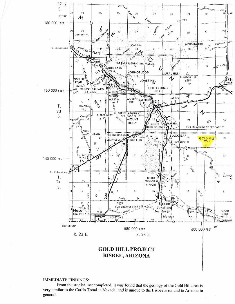
IMMEDIA TE FINDINGS:
19
BISBE(WEST
19 ~~
20 22
580 000 FEET
R. 24 E.
GOLD HILL PROJECT BISBEE, ARIZONA
23 24 19
)
25 30
-~-24 20
FOR ENLARGEMENT SEE PAGE 25
32
~)
GLANCE X'
-+- ----4- - -- --- -
CROOK ' . TUNNEL =----:1 E-- -l _
50'
From the studies just completed, it was found that the geology of the Gold Hill area is very similar to the Carlin Trend in Nevada, and is unique to the Bisbee area, and to Arizona in general.

GOLD HILL
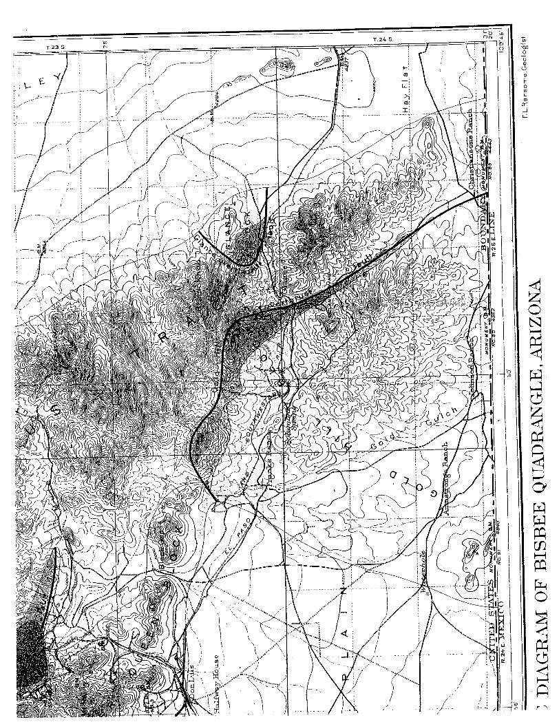
This is a brief geology report on the Gold Hill Mine or Gold Hill deposit located at Gold Hill, Bisbee, Warren Mining District in the Mule Mountains, Cochise County, Arizona. The mine is located in the SW 14, Section 30, 31 and 32, T ,223S, and R.25E. approximately 5 miles southeast of Bisbee on the south slope of Gold Hill at the upper part of Gold Gulch.
The over thrust fault of Gold Hill is connected with the Laramide orogeny. The Laramide orogeny occurred in a series of pulses, with quiescent phases intervening.
This event had its origins off the west coast of North America where the Farallon Plate was sliding (being sub ducted) under the North American plate. The Farallon Plate dragged along the bottom of the continental crust of the North American Plate, causing significant folding and faulting due the shallow angle of seduction and drag. Folds and faults in the Laramie strata resulted from block faulting and thrust faulting of the underlying basement complex and ore producing intrusions.
The Warren Mining District has been the largest gold producer in Arizona. The geology of Gold Hill is complex and is related to the Laramide orogeny and plate tectonics. At Gold Hill the Glance conglomerate beds are overridden by an over thrust block of Paleozoic limestone, and are locally turned up to a nearly vertical position in a compressed and slightly overturned anticline. Near the Gold Hill over thrust, the beds are upturned until they are practically vertical from the normal dip of 20 to 25 degrees to the northeast. Wherever the contact between the Paleozoic and Cretaceous rocks is exposed, the former are found to overlie the latter and to be separated from them by a zone of fracturing an~ brecciation. The approximate line of the fault can be readily followed along the north slope of Gold Hill, where it has a rather steep dip to the south and is accompanied by much crushing and disturbance of the underlying conglomerate and overlying Escabrosa and Naco Limestone.
The Cretaceous beds upon which the over thrust Paleozoic rocks rest are much disturbed in the vicinity of the fault. They are crushed and sheared and in some places metamorphosed to much-crumpled greenish sericitic schist. It is noteworthy that throughout its course, the Gold Hill fault actually outcrops with a somewhat steeper dip that might be expected from then general character of the over thrust. It is probable that this dip becomes less beneath the mass of the block and that its steepness near the present exposures of the fault is local. The over thrust was affected by strong compression acting along northeast-southwest lines. There is reason to believe that the hanging wall of the fault has been thrust over the footwall for a distance of at least 2 miles. As movement along the fault continued, the Paleozoic rocks of the hanging wall were thrust forward and upward until they pressed against the Cretaceous beds northeast of Gold Hill, and squeezed the latter into a closely compressed anticline in the immediate vicinity of the fault. The effect of the thrust appears also to have been recorded, at a distance from the fault, in the change of strike
I I'i . I
,I
ii i , 'I ; I·
ill ! I, i I
: I
and upturning of the Mural Limestone near the Easter Sunday Mine. It is probable that
the over thrust Paleozoic beds never extended much farther to northeast than the present
outcrop of the fissure. The steep dip of the fault where actually exposed and the nature of
the folding and squeezing of the Cretaceous beds in its vicinity, are phenomena to be
expected along the plowing front of a rigid over thrust mass, rather than in those portions
of the footwall which have been greatly overridden.
Bulletin 194, Metallic Mineral Districts and Production in Arizona, from the Arizona
Bureau of Geology and Mineral Technology reveals that the Gold Hill deposit shipped
1 700 tons of ore from 1901 to 1911 which yielded 1600 ounces of gold and 100 ounces of
silver. It also produced 50 tons of manganese ore which contained 52,600 pounds of
manganese.
The Gold Hill Mine consists of fourteen (14) patented claims which comprise over 250
acres. Silver Nickel Mining Co. has an interest in numerous patented claims in close
proximity to the north of the Gold Hill Mine.
There is a two-mile-long northwest-southeast fissure along Gold Hill. The replacement
masses contained copper oxides, barite, calcite and iron oxides and gold. About 50 tons
of manganese oxide were produced in 1918 (one carload). In the upper part of Gold
Gulch many placer gold deposits have been worked. The Gold Hill Mine is a prime
exploration target for gold along the over thrust fault fissure and Gold Hill block. Gold
has been produced from this area, and the surrounding area has been a placer gold source.
The high-gold, low copper character of the Gold Hill mine bodies, and their smaller
size, might reflect a zoning pattern from copper-rich, gold poor bodies in the center of
the district to gold-rich, copper-poorer bodies at the fringes of the system. The presence
of this metal zoning pattern and of peripheral manganese mineralization is similar to that
observed in some porphyry and/or intrusion related carbonate-hosted distal gold deposits
(e.g. Yauricicha (Peru) Bau (Malaysia) Cove (Nevada).
Chalocite is found irregularly but widely distributed through the large area of Glance
conglomerate stretching from Gold Hill southward for two to three miles. The mineral
occurs in minute reticulating veinlets, often microscopic in; size, and in little rounded
bunches, rarely over half an inch in diameter, usually enclosed within a thin envelope of
malachite. The chalocite is usually accompanied by the development of secondary quartz
in veinlets. Both chalocite and quartz have in part filled minute fissures in the
conglomerate, but have also in part replaced some of the finer interstitial, calcareous
matrix by which the pebbles are held together. Micron gold is also widely distributed
with the copper mineralization in the conglomerate.
In conclusion geological conditions are very favorable to the existence and presence of
large and profitable gold ore bodies.

Frederic M Rothermel Ph.D. Project Manager
Solomon Springs Copper Co. 5822 W. Michelle Drive
Glendale, Arizona 85308-1244 (602) 626-8604

.,{
.~\(,~"" ,
\
140000
FEET
T. 23 5
T. 24 S.
~ ! i : ') ( J ', 'I ( ):, ) \. ) ', ) l, ) i . ) \~ ) \~) ;, j ;.~ ,~ ,_) .J
/
.1 2
>22>30"t/ 11 / I \hl~k===:/;~~J)'J &:// ) ~·',L, ~'\J ~-~~ )l/d ia 109°52'30" '08 1 R. 24 E. '09 600000 FEET R. 25 E. I ~n" .
\\ Mapped, edited, and published by the Geological Survey o .\ S u~eno( c \6c~;;\O~'" M~ f')~
_':"~A t"'" ., ,.... .. r"\r"\r

(
t ':-Q p J ("'\
~ ~'''' : 0" (t) ,..-'
It It
I ~ z ()
I C
...-J C' .,. .ib
1 ~ \
~ t t
en G r>
0
()I
- C' ...1:. ~
i oQ
(f) CD
0 p
N N (0
~ ~ rt It
>
5 /
~ (
(
/ j
) N )
/ {
! I
( /0 ./! ,
mil~s /
Map concept; Richard I
Francaviglia
--Road
++++-++ Railroad
....--.-.- Flume
® Mine
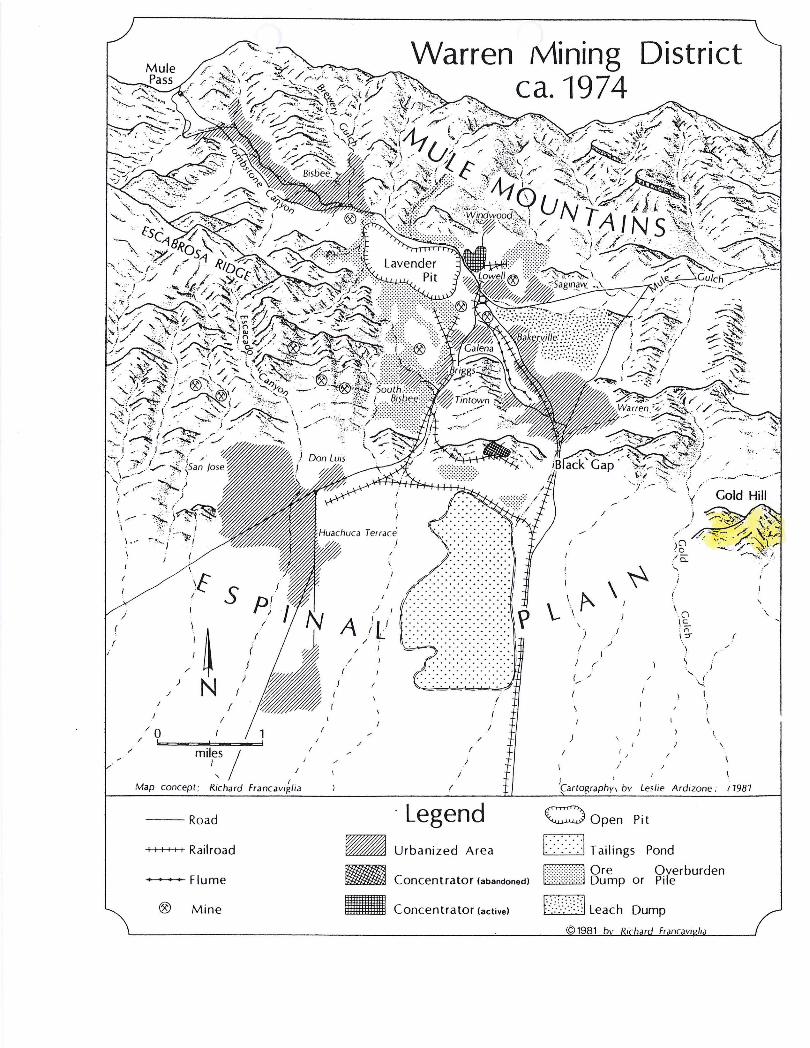
Warren Mining District
\
.1
ca. 1974
/
/
\~ ~ 1
A ./ I I ' , 1,1
ilL l
/
\(1 Ie. :r:; \:5"
(
I
/
/
/ : )
/
/
/
I
( .. ./
/
1 ,
\ \
"
\.,' I
I f Leslie Ardizone ;
Legend c::;) Open Pit
_ Urbanized Area 1::: :::: :::\ Tailings Pond
~ Concentrator (abandoned) ~ 8~~p or ~reerburden
_ Concentrator (active) F·:·Y·Y·;\ Leach Dump
\
17987

f C;oJj
u. ~. (.~lJl {h,ILAI '.tJIIVEY
?nOf[::,SIO;·.Al PAPEH NO. ~I PL. X;..II
.1 (,uLI) HILL I·RUM rHE NORTHVH.ST. :;,Hl)Wlt·JL-1 OVERTHRUST FAULT.
Ii (,UU) HILL FI~{)M rHE :'(llHH :)H')NI~J:~ ()/ElnHRlh!· FAULT.
276
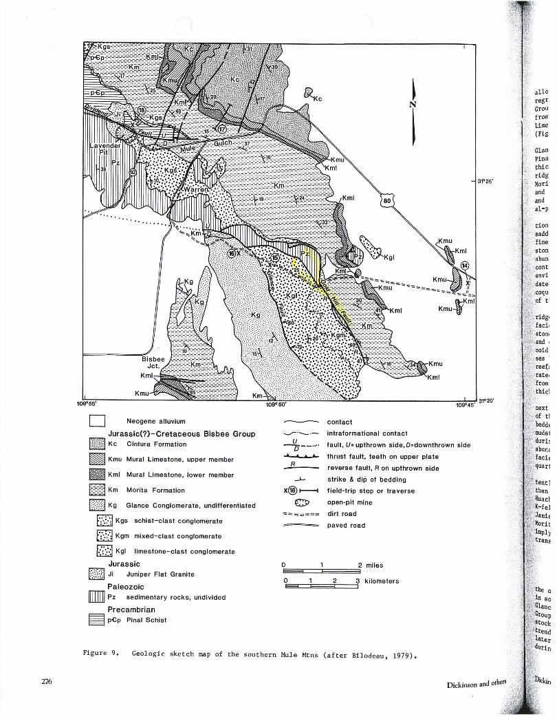
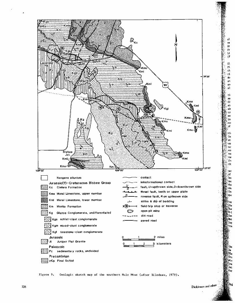
o Neogene alluvium
Jurassic(?)-Cretaceous Bisbee Group b)))mt~M Kc Cintura Formation
~ Kmu Mural Limestone, upper member
Kml Mural Limestone, lower member
~~:~:3 Km Morita Formation
k::;·:(.i Kg Glance Conglomerate, undifferentiated
f':';:.;":1 Kgs schist-clast conglomerate
f":';:d Kgm mixed- clast conglomerate
f.:':'::,:1 Kgl limestone-clast conglomerate
Jurassic
~-'-'; I .
,-' :. ~ ,,- JI , ,', .. .. Juniper Flat Granite
Paleozoic [llll] pz sedimentary rocks, undivided
Precambrian ~ p£p Pinal Schist
-- contact
--r-'_ .-u -0-_ ....
... • • +-
R
intraformational contact
fault, U= upthrown side,D=downthrown side
thrust fault, teeth on upper plate
reverse fault, R on upthrown side
strike & dip of bedding
field-trip stop or traverse
open-pit mine
dirt road
paved 'road
0EE33c::i===:r2==::5r kilometers
Figure 9. Geologic sketch map of the southern Mule Mtns (after Bilodeau, 1979).
Dickinson and others '
468 \101.-.5 THE COPPER HANDBOOK.
HORSE SHOE COPPER MINING CO. ARIZONA. Dead. Former office, Park Row Bldg., N ew York. Lands, near Safford ,
Graham County, Arizona, have passed to another corporation. Ignatius L. Qualey, president; Frank S. Weller, secretary; Chas. Carbonelle, treasurer
J
"Baker Tom" Putnam and" Larry" Summerfield, alias Fred Herbert, all have been sentenced to the penitentiary for swincUes connected with sales of stock of this eompany, their frauds being of a flagrant nature. HORSESHOE GOLD MINING CO. COLORADO.
Mine office: Central City, Gilpin Co., Colo. N. H. Scheur, superintend-'ent. Prope~ty is the Barnes mine, carrying ores of gold, silver and copper. Has steam power. HORSFAL MINING CO. COLORADO.
Mine office: Gold Hill, Boulder Co., Colo. D. Wiggens, superintendent. Ores carry gold, silver and copper: Has steam power and employed about
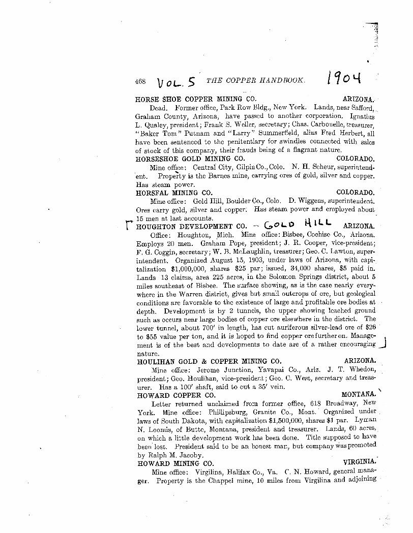
_ 15 men at last accounts. r HOUGHTON DEVELOPMENT CO. --., GO '- \) l~ 1 L L ARIZONA. Office: Houghton, .Mich. Mine office: Bisbee, Cochise Co., Arizona.
Employs 20 men. Graham Pope, president; J. R. Cooper, vice-president; F. G. Coggin, secretary; W. B. McLaughlin, treasurer; Geo. C. Lawton, superintendent. Organized August 15, 1903, under laws of Arizona, with capitalization $1,000,000, shares $25 par; issued, 34,000 shares, $5 paid in. Lands 13 claims, area 225 acres, in the Solomon Springs district, about 5 miles southeast of Bisbee. The surface showing, as is the case nearly everywhere in the Warren district, gives but small outcrops of ore, but geological conditions are favorable to the existence of large and profitable ore bodies at depth. Development is by 2 tunnels, the upper showing leached ground such as occurs near large bodies of copper ore elsewhere in the district. The lower tunnel, about 700' in length, has cut auriferous silver-lead ore of $26 ' to $55 value per ton, and it is hoped to find copper ore further on. Manage- J", ment is of the best and developments to date are of a rather encouraging nature. HOULIHAN GOLD & COPPER MINING CO. ARIZONA.
Mine office: Jerome Junction, Yavapai Co., Ariz. J. T. Whedon, president; Geo. Houlihan, vice-president; Geo. C. West, secretary and treasurer. Has a 100' shaft, said to cut a 35' vein. HOWARD COPPER CO. MONTANA.'
Letter returned unclaimed from former office, 618 Broadway, New York. Mine office: Philli psburg, Granite Co., Mont.' Organized under laws of South Dakota, with capitalization $1,500,000, shares $1 par. Lyman N. Loomis, of Butte, Montana, president and treasurer. Lands, 60 acres" on which a little development work has been done. Title supposed to have been'lost. President said to be an honest man, but company was promoted by Ralph M. Jacoby. HOWARD MINING CO. VIRGINIA.'
Mine office: Virgilina, Halifax Co., Va. r. N. Howard, general manager. Property is the Chappel mine, 10 miles from Virgilina and adjoining
IMMEDIA TE FINDINGS:
GOLD HILL PROJECT BISBEE, ARIZONA
From the studies just completed, it was found that the geology of the Gold Hill area is very similar to the Carlin Trend in Nevada, and is unique to the Bisbee area, and to Arizona in general.
March 2006

3C73
:40000 . FEET
T. 23 S.
T. 24 s.
? 0
~~~
/
,,'( '2 ../I'
2'30" +_
; 109 0 t2'30" . '08
Mapped, edited, and published by the Geological Survey Control by USGS and USC&GS
GOLD HILL PROJECT The Gold Hill project includes the old Gold Hill and Superior and Boston Mines in the
Warren Mining District, 2 miles southeast of Warren, Cochise County, Arizona. The following report is based on geologic studies completed by John B. Rothermel and
Frederic M. Rothermel, PhD in the spring of 2006. The over thrust fault of Gold Hill is connected with the Laramide orogeny. The
Laramide orogeny occurred in a series of pulses sixty million years ago with quiescent phases intervening.
The Laramide orogeny thrust a thick sheet of Paleozoic sedimentary rock (Escabrosa and Naco limestones) from the southwest up a gently inclined undulating fault fracture for a distance of several miles over Cretaceous beds. This thrust sheet is known as the upper plate of the Gold Hill Trend area, while the rocks it slid over are known as the lower plate.
The known ore bodies in the Gold Hill area tend to occur in stratigraphic windows that expose the lower plate rocks.
Several major and many minor faults run in this area. All of the faulting in the area created many conduits for large hydrothermal cells whose
mineral-rich waters emplaced the area. Alteration processes occurred including decalcification and breciation of the host rocks and dolomitization, sericite/illite alteration, silicification, argillization, barite-alunite alteration.
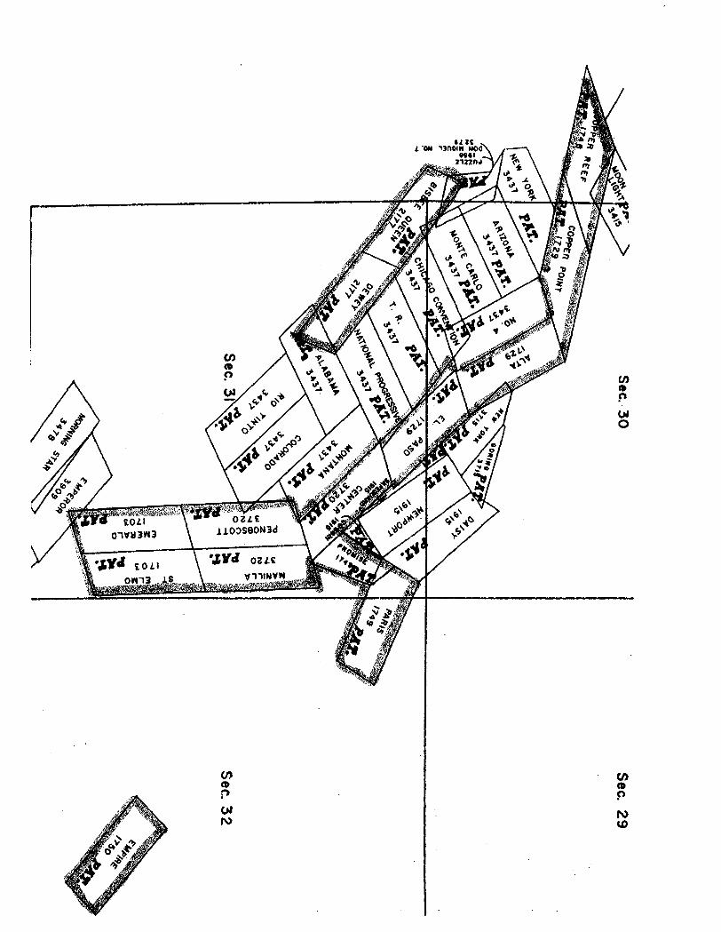
The Gold Hill patented claim group consisting of Mineral Surveys 1703, 1729, 1748, 1749, 1750, and 3720 cover this trend. Additional ground is available on Mineral Survey 2177, the patented acreage encompasses over 250 acres.
From this study and research, the structural geology of the Gold Hill project is very similar to the Carlin Trend in Nevada and is unique to the Bisbee area, and to Arizona in general.
John B. Rothermel Frederic M. Rothermel, PhD Project Managers- Gold Hill
5822 West Michelle Drive Glendale, Arizona 85308-1244
(602) 439-3143
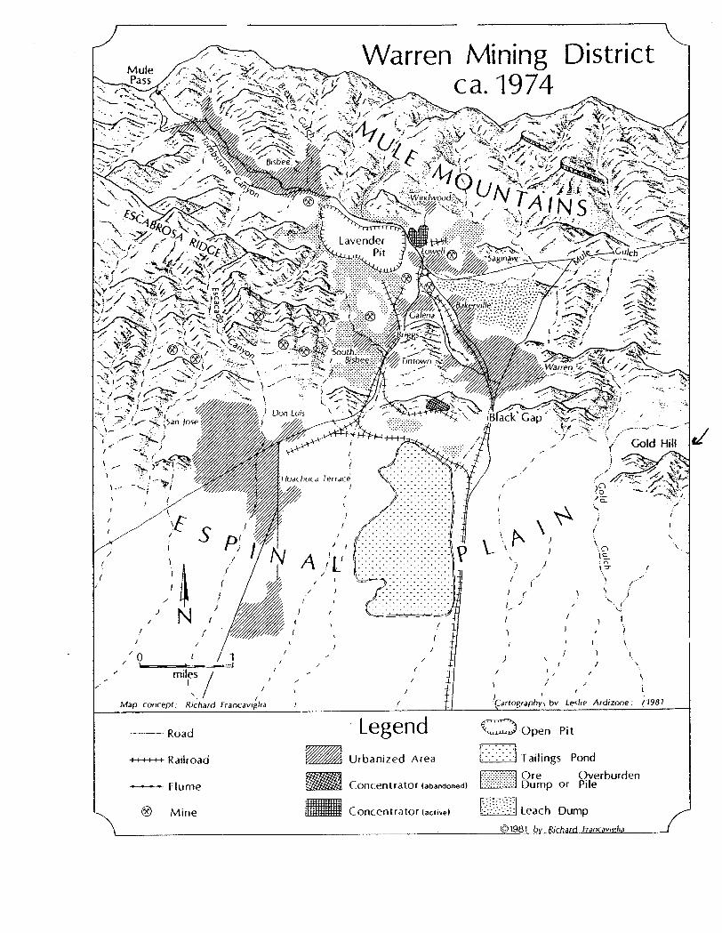
DIRECTIONS
How to get to the Gold Hill Mine, also known on maps as the Superior and Boston Mine.
Property is easily reached by going to Bisbee, Arizona. Bisbee is located 90 miles southeast of Tucson, and is nestled a mile high in the Mule Mountains of Cochise County. Bisbee was recently named one of the "50 Best Places to Live" by Modern Maturity magazine.
Once in Bisbee, travel about two miles SE to Warren, a suburb of Bisbee. Once in Warren, go south on the airport-Bisbee Junction paved road for % mile; turn left (east) onto a gravel road. This is Gold Gulch road and take it for a little over 1 mile until you come to a branch of two dirt roads. Take the road on the left. This is the Gold Hill Mine road (also known as the Superior & Boston Mine) for approximately 1 1;2 miles. This country road leads right to Gold Hill and to the property.
There are other roads going to the south end of the property as well. They are listed on the topographical map.
Although no mountainous grades will be encountered, a 4 wheel drive vehicle is recommended.
\
\..-
/
/'
)
/
~ N {
f I
/0 , 1 ,
/'
mil~s /
l
(
(
/ I
Map concept; Richard I
Francavj~lIa
--Road
++++++ Railroad
----- Flume
® Mine
Warren Mining District ca. 1974
Legend _ Urbanized Area
~ Concentrator (abandoned)
_ Concentrator (active)
'.
l
~rt.n""'~nh.,. bv Leslie Ardizone; (7987
c:;:)Open Pit
I>::: > :\ Tailings Pond
l}i~\JJId 8~inp or ~reerburden
t·}.:.:.:}·)~~lleach Dump

ACREAGE (Surface and Minerals)
The property includes 7 official United States Mineral surveys.
1) Mineral Survey 1703 St. Elmo Lode 19.96 acres Emerald Lode 19.96 acres
Total acreage: 39.920 acres
2) Mineral Survey 1729 El Paso Lode 20.637 acres Alta Lode 20.654 acres Copper Point Lode 20.645 acres
Total acreage: 61.936 acres
3) Mineral Survey 1748 Copper Reef Lode 20.645 acres
4) Mineral Survey 1749 Paris Lode 19.45 acres Promise Lode 9.483 acres
Total acreage: 28.933 acres
5) Mineral Survey 1750 Empire Lode 20.245 acres
6) Mineral Survey 3720 Center Lode 18.573 acres Manila 19.968 acres Penobscott 19.968 acres
Total acreage: 58.509 acres
7) Mineral Survey 2177 ~ Undivided interest Bisbee Queen Lode 17.123 acres 36.762 acres Dewey Lode 19.040 acres
~ Undivided interest 18.381 acres
Total acreage of 14 patented mining claims comprising Gold Hill Mine
248.569 Acres
en (D
$")
01 I\)
CJ) ca P 01 o
(I) a. p
N U)
276
D Neogene alluvium
Jurassic(?)-Cretaceous Bisbee Group f})fmMr~ Kc Cintura Formation
~ Kmu Mural Limestone, upper member
• Kml Mural Limestone, lower member
~:::::::a Km Morita Formation
((;;(1 Kg Glance Conglomerate, undifferentiated
fO:·;o:.:oJ Kgs schist-clast conglomerate
b::J Kgm mixed-clast conglomerate
fo:o;:~o:l Kgl limestone-clast conglomerate
Jurassic ,-,,:~,,- JI ~-'.;' . "'- Juniper Flat Granite
Paleozoic [lllill pz sedimentary rocks, undivided
Precambrian § p£p Pinal Schist
--- contact -...-;-._.-
u -0-_ .... • • • +-
R
intraformational contact
fault, U= upthrown side,D=downthrown side
thrust fault, teeth on upper plate
reverse fault, R on upthrown side
strike & dip of bedding
field-trip stop or traverse
open-pit mine
dirt road
paved road
o 2 miles ~~:::::E:::::===3
0EE33=:E=32c:=::j~ kilometers
Figure 9. Geologic sketch map of the southern Mule Mtns (after Bilodeau, 1979).
Dickinson and
-_ .. -" -_. '.-'- .... -. II T-' peoIT-. ·ONWOOD 1 -KT. ~ SAN JUAN 1a-eT -4J/IiI4it/Jl--I.V''1C: .;,'~n. '''-'''. I . . .... WOO~EY 1a- KT.J . '.' ' .~_ ... _ ..... ..;_ .. __ .." . . ~. TWIN PEAKS 4- mT ----f~i:p . -~-.-' -JL--r-RrpsEYf'a.~-KT"--- -------.•. -- ; .. ,: •. ,,, -AFt~VAIPA 4- mT ... " (#--- SANCHEZ 18-.eT; - ~ , •. ZlG:ZA~ 6a- mT --e .... ~ o--.,ANTELOPE 2- P£1! ~ . ,.' ! \ . _
: \ ,f GRAND PRIZE 1a- KT ~ . v". .• "'.~'. .' ", .' GOAT CAMP 6a mT-., " ........ : ,";: '-" .. ~-... : :CRESCENT 6a-:mT ' . ..i:.. ._ ! ... ". .--Sal. 181-eT7'
~'1a7': KT7'~ '. ~ GOLD CIRCLE 8- eT1 --c> ~ . ~! TABlE ~N. 1b- mT . -~_~~ARK 4- mT '.. . '. . :; B . ,.' ~ SWINGLE6a-mT' ~ I; .-'- ", .•• : I
:' .. ':. i LA~~ MTN. ~-:!~T?~'':'-:'.M'' ~.... ,:' ,- Al·~.JB·:":'KiR·~iLL 1 -K+ .~.BLAC~.HAWKs;.-:.mT .. ,,,I' ". i"? '''' .. :> .'. "', (lOY' 1 ,,' I • .-r- VI" a '-I ~. ". . . .... 1 ,." \J\. ".t
REEF.i~:':o~T,/; .... _.".. 1 ~ ~ ... ~.~:) "', ~·'~MAMMOToK:31....m1c'~~, .. \o:::=-BLA?~~~\~~Y8,":-m~.:,,'· ~ • / ASH,'peAK5-mT
?URHA~c,.~ul~91a-tT N. ','.,,;,;' ••• :SAN MA~U~1.~":-KT l:,' ',"" I., ".:," .. ,,~.::~' : ~'11 RANCH10~-IT 02-mT -'",' J ~ '-' .. ~ n (.,x j.;. . - ...... " )'" • ~ , ' ' LITTLE' HILLS 18- KTol., '0 ~t::·; :.... RATILESNAKE 5~"m'f' L I ',1, ... ."." "\ ;' .OOTH6a-m'-F"'\ .' ~."!": I. .:"~'''-''f--r' I' ""''''', I f",,·;I.. \ ", KIMBALL 12 T" -:-.- .. OWL HEAO-2;;,T ' '.' .. (rr: ... "UOI ,.' c;, '. I r'~ L v I' - m -0
J ---- M ..... <~\'t I' ',. 0 ..... 'r-..J.' .' '·ORACLEa- .. r" ~ -. \ .~~ I : .. ' . - ' . !" .. T~" OLlTA1a~KT':'~' ~'J.:t"<1".j ~aURN.EY~a-KTI.'" ~~~h'" .: I'V I I'. :.,.~'"YII'':'~ --.- •• ---.--:.:!---,.:,.----.. ---.-
-KT • , " \ '" r--'.....,~"'-.''--'''-,., 'J JIi!3,--.---- f L - " l GOLAN DR INA 12- m;r··"·'.:;c-...:- ""'\- FISHER HILLS 6 T -~-,,-, ... - .. ------- -'--:""'- .... u ~ ",' .., .• ' 1 r,FlEST .. , .: ~ a-m \' I
MAGONIGAL ,a-,1;<T '-..- I "\. • '~~. I' :::.... '.' "'"\" \ L -. I .. . - I •• _:'. ~ • _ •. _. __
/ r "" .. CA~DEL QRO·3-m", ~ ~'''~~. _w.""'" .". MARBL5.,.8lliA~1'~_._~_=:_.-~.-.-.-·-:_--.---·-·-~---· .......... ·---.-.-.-. ~.!.!t~:::..:;.;-- SILVER w.. 1a~KI,.· "'1-" ""--::i c ') R 'j~ o· "1 ReDiNGTON 1a- KT ~\ - .~ , I ~ .": ",\ MOlfE··4"r::!1I~';:::': .\ ~ \ ~ .. I,., ... ,. \ #--SP'KE.~~HILLS4~mT· '\ 1...-.-. ';~ ·.F ir..,l.,. r 12 . to . '.,.';.- . c. .., """"I t ... ' . :.~ .~""-'.. .. -'. ' .. ,,, .. ~ .. PELONCILL05?-mT
-IK~ :. ~'V<". r:'l '~+~ .. '-' :~'-~CA1AUIM~1a-Ki'" .... )<t;.~~ -~ ... 'B~UE ROq< 1 or-. -"i~'7' J<'." t'EV1S}ON 1a-.. KT~ _ ...... ,<.. ~ASCOT1a-eT·:.,::::.· \.
\ ., i~.'~"" \ ~;\5";"'" .:o.~- :'J''' .. \ LL. I '. WINCHEste~14-el___~~. ,: ..... , .. ~.,.._.~.",. APACHE PASS 3-mT~~" . <:" .~ L. ~. \"'. i" .,~;,",,~ - ,.F ') P ~ ~; _. ..!: . .!...~ ..... ---, SILVER CAMP·f8- KT -..... ~ ,
. ...j. ..... ... .. --.... 7;1' .. SeQIMt:NTARYHILLS:·1!=~T· - - .l-. ~ ''"~ . .'/ ---",-"" "'e' 'SKRUGE ia-KT ---. i 111~--" .' TUCSON. ' ..... ur ........... , I 'u.~, ; .. ' ~ '-
"::. --- --: =-... II .. :~"" ,'. I ~::OU.1EN SA!3E.1~-.;K.::TUA~9 :"":;;~"L \ ,. . YELLOWSTiONE 3- niT.' . I, , ... . . --J " 5r~c;:,c"'1-'·:"": '~.'.' 6c ,..6. . I I.;~ t".. ,: I .
';" - - - J.. ~S~~Itl!.AW HiLLP.a-:·tcr)"':.:,,:,,r ~I fr- ---: -Wttl:COX'~b-lT. ' •. - '.""'-:'::"
\815·- eT -1:::: 1 ___ 1 .M CARij)~~ AVE, 10b- mT~ i ...;,,1 ! 1 i~ '";CO~~I~E_l~T_, ___ . __ --_. _ '--,-.. '_1_. _~-::::-;;;:. ___ -=--.1..1 __ '-:":'~~:;:;:':~.:..' -lr-! _. _I'f-::-:-::-'-;:-:;:;-::--;-I ~::-F-'."" -; , ... I RINCO~'2-Il1T'" '[.0; • I' GOLDEN RULE 3·-IK ". <::.' I
i i .... '<V"" 1 .-.".'. ".:!'" ~ 'BLUEBIAD8 T' ~ : .J PAT HILLS·~-.-.mT-;· ; i '-.<' .. -- -, -e·...· . cc:s-- ... L.I~~:~:'::'!I~:~':' '-
C J":'::~' IPEAR{;E 5-!inT 1.- r.-~,:\~.,_ ' .,' ... ~-- .. . . .... CAUF.eRNIA4- m . ;
. ; r J ~:.";';;;;::,::::.?,.,, -:~.l·· ' ..
J
RUCKER CANYON 4~mT .
". ~ T,UROU~'~E 1a-J? ' . ~,.;;" "
. ,.,,,.,," I"':· ).-. 5~'~HELM ~ -.. ,. ,~ .... i . "", .~~ '" .-".·~f _-'._-1
6- -' -~..... . 0<- . ," " Vol II!: O~ _____ I I.JMBSr.oN~ 4- IK'.:. ;.~ ---= J -.-. J ... 1 '-MM~CrIE"",p4-If€/Q ~"', ... ' • ;\t ",,"-:,~ J; \: i"'~:""""" .. ~,:: •. ~. '.,:.1
GOTT6NWob~:~~~.'N6.-;;;'r +J-I .. )j~~ ::~~.~~:::/' ./:. -'!
K
~
L
10
- -- ~-~ ~ ~V&v!:Sy uuu !'U"~Jd' lC(,;ldIUlUYY G{: J9ical Survey Branch
Tucson
Se.i. 1: 1000000
... --:.::.----ti.-:.= . __ . ___ <0 ...... 10 0 10 lO )0 <10 Y.' 1{':~I~·t t::('H.B..E{'"E': .. :-_._._ --:-=..:. __ -=-....:....F....:..::.:·· .:'. 'I , ..•.. -":-·-:1.-:-":':"-:.::a
Scale
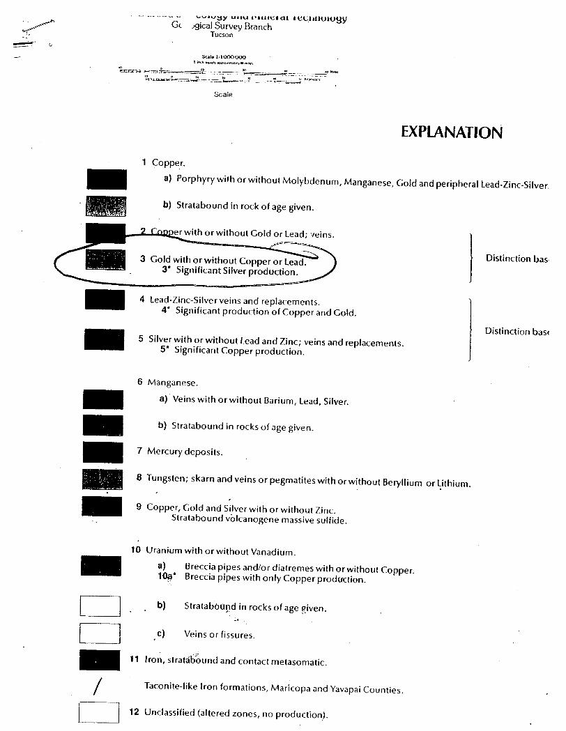
EXPLANATiON
1 Coppe.L
a) Porphyry with or without Molybdenum, Manganese, Gold and peripherallead-Zinc-Silver.
- '", . ", .. -.' .. : b) Stratabound in rock of age ·given.
_ ............. "'IIQ;~r with or without Cold or Lead; ·-Ieins. I Distinction bas·
D D
3 Gold with or without Copper or lead. 3* Significant Silver production.
4 Lead-Zine-Silver veins and replacements. 4* Significant production of Copper and Cold.
5 Silver with orwithout lead and Zinc; veins and replacements. 5* Significant Copper production.
6 Manganese.
a) Veins with or without Barium, Lead, Silver.
b) Stratabound in rocks of age given.
7 Mercury deposits.
8 Tungsten; skarn and veins or pegmatites with or without Beryllium or ~ithium.
9 Copper, Cold and Silver with or without Zinc. Stratabound volcanogene massive sulfide.
10 Uranium with or without Vanadium.
a) Breccia pipes and/or diatremes with or without Copper. 1~* Breccia pipes with only Copper production.
b) Stratabound in rocks of age given. :.:..
c) Veins or fissures.
11 Iro~f stratab~und and contact metasomatic.
/ Taconite-like Iron formations, Maricopa and Yavapai Counties.
i==:=J 12 Unclassified (altered zones, no production).
Distinction bas4
·e text).
)5 (see text).
".;
\.~
...
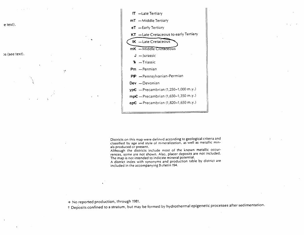
IT -Late Tertiary
mT -Middle Tertiary
eT - Early Tertiary
KT -Late Cretaceous to early Tertiary ".-
mK -Middle
J -Jurassic
R -Triassic
Pm -Permian
eous
PP -Pennsylvanian-Permian
Dev -Devonian
yp€ -Precambri;ln (1,250-1,000 m.y.)
mp€ -Precambri.3.n (1,650-1,350 m.y.)
ep€ -Precambrian (1,820-1,650 m.y.)
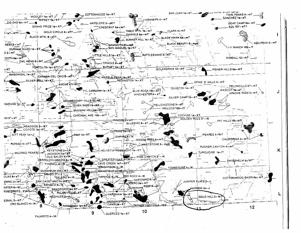
Districts on this rt:lap were defin(!d according to geological criteria and classified by age and style of mineralization, as well as metallic minals produced or present. Although the districts include most of the known metallic occurrences, some are not shown. Also, placer deposits are not included. The map is not intended to indiC3.te mineral potential. A district index with synonyms and production table by district are included in the accompanying Bulletin 194.
+ No reported production, through 1981. t Dep'osits confined to a stratum, but may be formed by hydrothermal epigenetic processes after sedimentation.
I
/ .;<..
/ /
i i i
I·· -I -;1
+III
;00 o o Q) o
q}
E o III C co tr ..J u.:
•
""d" wa::cz:2I,iiCl!.t WU:2~Q, ~"';:;""':' __ .A"'--"",; __ •• ~ _________ _
METALUC MINERAL DISTRICTS AND
PRODUCTION IN ARIZONA
Stanley B. Keith, Don E. Gest, Ed DeWitt, Netta Woode Toll, Beverly A Everson
Bulletin 194
1983
ARIZONA BUREAU OF GEOLOGY AND MINERAL TECHNOLOGY
The Bureau of Geology and Mineral Technology Is a division of the University of Arizona, an Equal Opportunity, Affirmative Action Employer
IL.
:·1
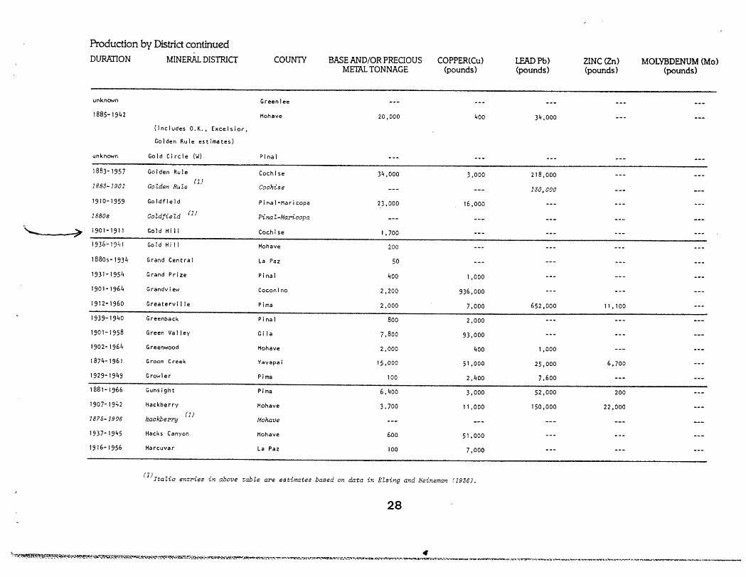
Production by District continued
DURATION MINERAL DISTRICT COUNTY BASE AND/OR PRECIOUS COPPER(Cu) LEADPb) ZINC (Zn) MOLYBDENUM (Mo) METAL TONNAGE (pounds) (pounds) (pounds) (pounds)
unknown Greenlee
1885-1942 Mohave 20,000 400 34.000
(Includes O.K., Excelsior,
Golden Rule estimates)
unknown Gold Circle (1oJ) Pinal
1883-1957 Golden Rule Coch I se 34,000 3,000 218,000
1883-1901 GoZden Rule (1)
Cochise 130,000
1910-1959 Go I dfi e I d Pinal-Maricopa 23,000 16,000
1880s GoZdfieZd (1)
PinaZ-Maricopa
',,-- ~ 1901-1911 Gold Hi II Cochise 1,700
1936-1,)111 Go I d Hill Mohave 200
18805-1934 Grand Central La Paz 50
1931-1954 Grand Prize Pinal 400 1,000
1901-1964 Grandview Coconino 2,200 936,000
1912-1960 Greatervi lie Pima 2,000 7,000 652,000 11,100
1939-1940 Greenback Pinal 800 2,000
1901-1958 Green Valley Gila 7,800 93,000
1902-1964 Greenwood Mohave 2,000 400 1,000
1874-1961 Groom Creek Yavapai 15,000 51,000 25,000 6,700
1929-1949 Growler Pima 100 2,400 7,600
1881-1966 Gunsight Pima 6,400 3,000 52,000 200
1907-1942 Hackberry Mohave 3.700 11,000 150,000 22,000
1875-1906 Hackberry (1)
Mohave
1937-1945 Hacks Canyon Mohave 600 51,000
1916-1956 Harcuvar La Paz 100 7,000
(1JltaZic entries in above tabZe are estimates based on data in Elsing and Heineman (1936),
28
. 4 ~.~~.{f!f~~~~;'~"L~·~·,~~~~~~~~--r...:"..o~~;~-:;:~l,:.:-&-;:·5':'.:f~:-.·.~~t...¥~~~~~'/I'1..';"""I .. ",."",.~,...· ..... ,..;'\o~·,,,.(!~~,..~."'t'l'\~;s..,"'rr .......... ~ .. ~:-a~ ... 'A":"t*.c::':t"'~":':"'l.'~"""~~"'.~:"~" ... '"l":--:'~~""" __ .'-~"--__ V":':'!'l..~f.·~~~ .... ':b"'_~,,"N"<'.-""""'_"'\'G"W\"'''''~~.'''~;r ......... t'"C. .. ~ •• _~ ...... '""-_____ _
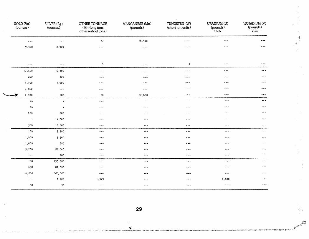
GOLD (Au) SILVER (Ag) OTHER TONNAGE MANGANESE (Mn)- TUNGSTEN (VI) URANIUM (U) V7\NADIUM (V) (ounces) (ounces) (Mn-Iong tons (pounds) (short ton units) (pounds) (pounds)
others-short tons) U30a V20S
77 74,500 ;!I
9,400 2,900 . i
5
10,500 16,300
200 300
5,100 4,000
3.000
~ 1,600 100 50 52,600
40 +
60 +
200 300
+ 14,000
300 16,800
100 3,200
1,400 5,300
1,000 600
5,200 86,000
200
100 133,500
400 81,000
5,000 560,000
1,200 1,329 4,800
30 30
29 .. ' .... ,!
'.' ... , ..••.. ' .,. ___ ._ •.. _ ....•. __ • __ . __ .. " • __ • .-"._ •• , ,,, ... ______ >" •.•. "_~ .. _-." ... " """'''_''_'~''_'~_''~~''''''.'''''''''''<''':'''.'''''::' •. :'.~' .... v t,.?·Jltl

rr-------. ---.-~----r-----T--J • ,
• f:J I' I . 1 : I Cd ,
I " .
JI M -. ~ ...
.............. .................... i
~I .................
...... .........
Scale ?~5~~9~ ___ S~5 __ ~
------. , I I
\ I I
\ 1
\ I I
l
Figure I.-Index map showing location of Arizona gold placer districts.
1- Gila City (Dome). 21. Granite Creek. 40. Canada del Oro. 2. Laguna. 22. Lynx Creek. 41. Clifton-Morenei. 3. Muggiris. 23. Copper Basin. 42. Gila River. 4. Castle Dome. 24. Groom Creek. 43. Alder Canyon. S. Kofa or S. H. 25. Big Bug. 44. Quijotoa. 6. Tank Mountains. 26. Hassayampa (Yavapai 45. Papago. 7. Trigo. County). 46. Armargosa. 8. La Paz. 27. Model. 47. Old Baldy. 9. La Cholla, Oro Fino, 28. Plaeenta. 48. Greaterville.
Middle Camp. 29. Weaver, Rieh Hill. 49. Las Guijas or Arivaca. 10. Plomosa. 30. Minnehaha. 50. Tyndall. II. Harquahala. 31. ·Black Canyon. 51. Harshaw. 12. Chemehuevis. 32. Humbug. 52. Patagonia or Mowry, 13. Silver Creek. 33. Vulture. Palmetto. 14. Lewis. 34. Hassayampa (Maricopa 53. Nogales. 15. Lookout. County). 54. Oro Blanco. 16. Wright Creek. 35. San Dominga. 55. Teviston. 17. Willow Beach. 36. Payson. 56. Dos Cabezas. 18. Gold Basin. 37. Globe-Miami. ~57. Pearce. / 19. King Tut. 38. Dripping Spring. 58. Gleeson. 20. Eureka. 39. Barbarossa. 59. Gold Gulch (Bisbee).
60. Huachuca.
Arizona Bureau of Mines Bulletin 11 168.
,j.'
"'):" ..... ',' ~.' ~. ' : .~ .,,: ": .. "" ~~. :: .. -:
': j'" ~'. ," ..... . ..
. ",' .......
INDEX OF MINING PROPER TIES IN
COCHISE COUNTY, ARIZON A
by
Stanton B. Keith Geologist
THE ARIZONA BUREAU OF MINES
Bulletin 187 1973
THE UNIVERSITY OF ARIZONA
TUCSON
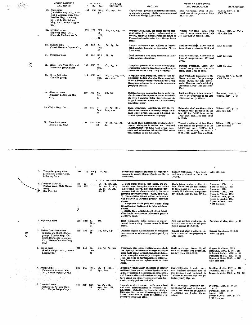
If. , MINING DrsTRICT LOCATION MINERAL TYPE OF OPERATION .. l~·-" AND MINES R. Sec. PRODUCTS GEOLOGY AND PRODUCTION REFERENCES
28. Muso mine .9S 25E NE\: Cu, Ag-, Au- Cupriferous, pyritic replacementorebodies Shaft workings. Over 12 thou- W.i1son, 1927, p. 61 (Leadville Mng. Co., Calu- 20 in steeply dipping, highly metamorphosed sand tons of ore produced from ABM file data met" Arizona Mng. Co., Cambrian Abrigo Limestone. 1917 to 1924. Needles Mng. "Smltng Co., U. S. Smltng and Rfng. Co., Andes Copper Co.)
29. Mystery mine 19S 25E SE\: Pb; Zn, Ag, Cu- Oxidized lead, zinc, and minor copper min- Tunnel workings. Some 9300 Wilson, 1927, p. 77-78 ,(Mystery Mng. Co., 29 eraliution in irregular replacement ore- tons of ore produced from 1924 ABM file1lata Minerals Exploration Co. ) NE\: bodieS, controlled by fractures and faults in • to 1930 and 94 tons in 1942.
-32 Pennsylvanian-Permian Naco Group lime-stone.
30. OntariO mine 19S 25E E. Cu, Ag, Au Copper carbonates and sulfides in bedded Shallow workings. A few tens of ABM file data (Great Western Copper Co.) Cen. replacement deposits in Cambrian Abrigo tons of ore produced, 1911 and
20 Limestone.
31. Poorman mine 19S 25E SE\: Pb, Ag Lead carbonste ore along fissures in Cam- Shallow workings. A few tens of ABM file data 17 brian Abrigo IJmestone. tons, of ore produced, 19111Uld
1920.
00 32. Sadie, New Year Gift, and 19S 25E E. Cu, Ag, Au Irregular pockets of oxidized copper min- Surface workings. About 100 ABM me data ~ Grenadier group mines Cen. erallzaUon in faulted and fractured Pennsyl- tons of ore produced intermit-32 vanian-Permian Naco Group limestone. tently from 1919 to 1925.
33. Silver Bill mine 19S 25E No. Pb, Zn, Ag, Cu-, lrregular.smaUstringers, pockets, IIJId re- Shaft workings connected to the Wilson, 1927, p. 74-75 (Costello group) Cen. Au-, Mo- placement bodies of oxidized base metslsul- Mystery mine. Large tonnage ABM me data
32 fides in Pennsylvanian-Permian Naco Group mined during the late 1800's, limestone adjacent to a quartz monzonite and 6,570 tons produced during porphyry contact. the periods 1922-1930 and 1938-
1941.
34. Silverton mine 19S 25E No. Cu, Au- Oxidizedcoppermineralif.lltion in an irreg- Shaft workings. A few thousand Ransome, 1912, p. 7 (Calumet" Arizona Mng. Cen. ular blanket-like deposit in thrust faultbec- tons of ore produced in the late Wilson, 1927, p. 58 Co.) 21 cia with Cambrian BoIs8 Quartzite and A- 1800's and esrly 1900's.
brigo Limestone above and Carboniferous limestone below.
35. (Tejon Mng. Co.) 19S 25E W. Cu, Ag, Pb-, Thin, irregular, cupriferous, pyriti~, re~ Extensive shaft workings. A few Wilson, 1927, p. 72 Cen. Zn-, Au- placement orebodies in Pennsylvanian-Per- thoUlland tons produced in the ABM file data 32 wan Naco Group limestone adjoining in- late 1910's, 5,200 tons during
trusive quartz monzonite porphyry. 1923-1928, and 1,180 tons, 1952 to 1956,
36. Tom Scott mine 19S 25E Cen. Pb, Zn, Cu, Ag, Oxidized base metal sulfide orebodies in ir- Tunnel workings. A few thou- Wilson, 1927, p. 72-74 (Tcjon Mng. Co.) 32 Au regular stringers in faulted and fractured sand tons of ore produced in the ABM file data
Penpsylvanian-PermJan Naco Group lime- 1880's and early 1900's, 440 stone and as bunches in brecc1s-fllIed solu- tons in 1929-1933, 890 tons in Uon cavtUeI! in the limestollll. 1943-1947, and 170 tons in 1954.
37. Turquolsc group mlnc 195 2SE NW\: Cu, Ag- Bed!:lecJ rcplaccment deposits of copper cor- Shallow workings. A few hund- ABM file data (Turquoise Copper Mng. 17 bonates in steeply dipping Csmbrlan Abrlgo red tons produced in the early " Smltng Co. ) Umestonc. 1900's.
~ XV(Wnrren District 22- 23- Cu, Pb, Zn, Ag, 1. Base metal' oxides, carbonates, and sul- Shaft, tunnel, andopenpitwork- Ransome, 1904, a, b ~ '(Bisbee area, Mule Moun- 245 25E Au, Mn, F, (Cd, fides in lorge, trregular replacement bodies iogs. More than 150 mlllion tons Bonillas et alia, 1917
", tains) " Bi, Se, Te, As, in tllted and faulted PaleozoiC limestone for- of balle metal ore and approxi- Ransome, 1920 ._ (See Fig. 9.) Sb, U) matlons that have been tnvaded by Jurassic mstely 35,000 tons of manganese Trischka, 1931, 1938
granitic porphyry stocks, dikes, and stlls. ore mined Since the late 1870's. Hogue" Wilson, 1950 2. Disseminsted copper oxides, carbonates, Burnham, 1959, p. 31 and sulfides in Jurassic granitic porphyry Hayes" Landis, 1964 stock. Bryant" Metz, 1966 3. Manganese oxide pods and lenses along ABM file data fractures and lault zones in Paleozoic lime-
I stones. 4. Spotty base metal and gold-silver m1ner-aHutlon in quartz veins in Jurassic granitic porphyry stock.
1. Bay State mine 23S 24E E. IItn Hard manganese oxide masses in discon- Adit and surface workings. A- Farnham et alia, 1961, p. 19 Cen. nected lenses along fissure zones in lime- bout 800 tons of sorted ore pro-21 stone. duced around 1917-1918.
2. Bisbee C9al1tion mines 22S 23E 26- Cu, Au-, Ag- Oxidized copper mineralization in irregular Tunnel and shaft workings. A- Copper Handbook, 1912-13 00 (Eureka and North Bisbee 27 quartz veins in a Jurassic granitic porphyry bout 75 tons of ore produced in ABM file data 01 groups; Eureka Mng. Co., stock. 19l1-1913.
North Bisbee Development Co., Bisbee Coalition Mng. Co.)
3. Boras mine 23S 24E So. Cu, Ag, Au, Mn Irregular, pipe-like, replacement orebod- Shaft workings. Some 50,000 Copper Handbook, 1926 (Phelps Dodge Corp., Boras Cen. ies ofptlrtly oxidized copper mineralization tons of copper ore produced, Ransome, 1920, p. 104, 110 Leasing Co. ) 21 along fault zones in Cambrian Abrigo Lime- mainly from 1920-1926. Wilson" Butler, 1930, p. 43
stone. Irregular and spotty stringers, vein- Farnham et alia, 1961, p. 21 lets, and pods of hard manganese oxides a- Bryant " Metz, 1966, p. 202 long fissures and as replacementa in lime- ABM file data stone.
4. Briggs mine 23S 24E NW\: Cu, Pb-, Zn-, Irregular replacement orebodies of largely Shaft workings. Probably sev- Bonillas et alia, 1917, p. 329 (Calumet" Arizona Mng. 22 Ag-, Au- oxidized, base metal mineralization in re- eral hundred thousand tons of Trischka, 1938, p. 37 Co" Phelps Dodge Corp.) lat1vely unaltered Mississippian Escabrosa ore produced and included in Bryant" Metz, 1966, p. 200-201
and Devonian Martin limestones along frac- Calumet" Arizona and Phelps ture zones and closely associated with Jur- Dodge yearly figures. assic porphyry dikes and sills.
5. Campbell mine 23S 24E SElj; Cu, Pb-, Zn-, Largely oxidized copper, with minor lead Shaft workings. Probably pro- TriBchka, 1931i, p. 37-39, (Calumet" Arizona Mng. 15 Ag-, Au-, (Bi, and zinc, mineralization in irregular re- duced several hundred thousand fig. 6 Co., Phelps Dodge Corp. ) In, Sn) placement orebodies in Cambrian Abrigo, tons of ore; included in Calumet Burnham, 1959, p. 17
Devonian Martin and Mississippian Esca- & Arizona and Phelps Dodge Copper, 1962 brosa limestones in close association with totals. Bryant" Metz, 1966, p. 201 porphyry dikes and sills. ABM file data