Embed Size (px)
Citation preview
3
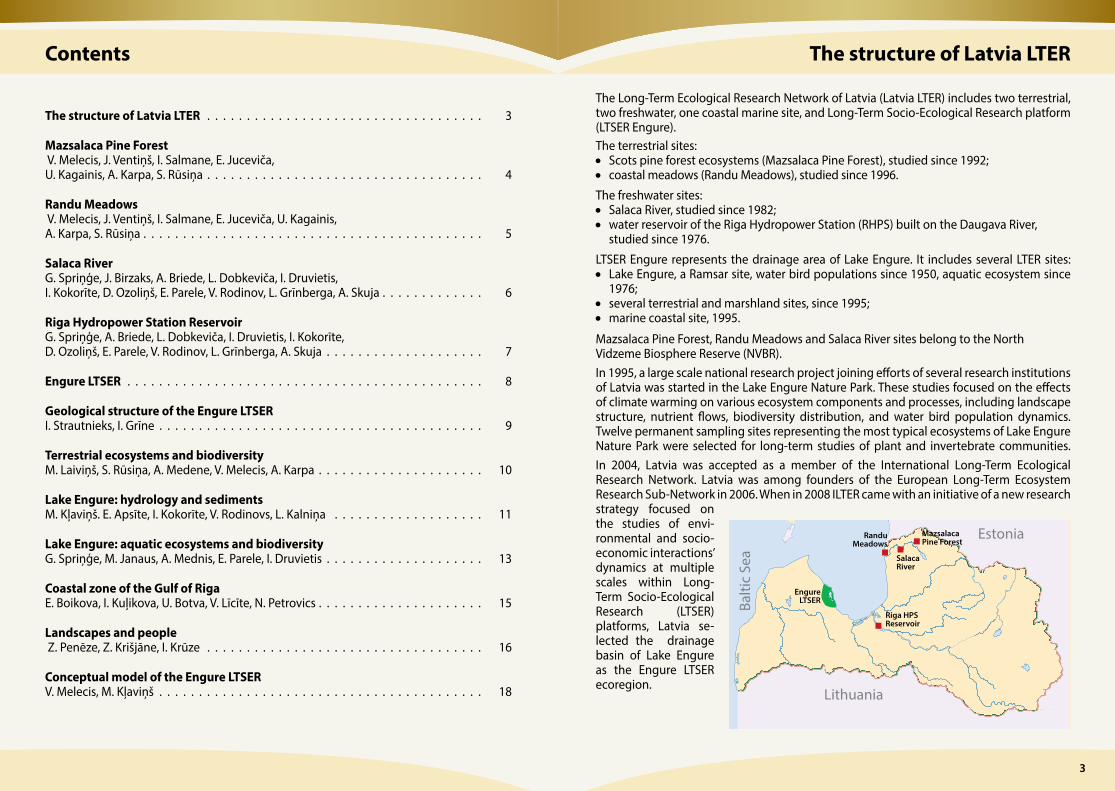
The structure of Latvia LTER
The Long-Term Ecological Research Network of Latvia (Latvia LTER) includes two terrestrial, two freshwater, one coastal marine site, and Long-Term Socio-Ecological Research platform (LTSER Engure). The terrestrial sites: • Scots pine forest ecosystems (Mazsalaca Pine Forest), studied since 1992;• coastal meadows (Randu Meadows), studied since 1996.
The freshwater sites: • Salaca River, studied since 1982;• water reservoir of the Riga Hydro power Station (RHPS) built on the Daugava River,
studied since 1976.
LTSER Engure represents the drainage area of Lake Engure. It includes several LTER sites:• Lake Engure, a Ramsar site, water bird populations since 1950, aquatic ecosystem since
1976;• several terrestrial and marshland sites, since 1995;• marine coastal site, 1995.
Mazsalaca Pine Forest, Randu Meadows and Salaca River sites belong to the North Vidzeme Biosphere Reserve (NVBR). In 1995, a large scale national research project joining efforts of several research institutions of Latvia was started in the Lake Engure Nature Park. These studies focused on the effects of climate warming on various ecosystem components and processes, including landscape structure, nutrient flows, biodiversity distribution, and water bird population dynamics. Twelve permanent sampling sites representing the most typical ecosystems of Lake Engure Nature Park were selected for long-term studies of plant and invertebrate communities. In 2004, Latvia was accepted as a member of the International Long-Term Ecological Research Network. Latvia was among founders of the European Long-Term Ecosystem Research Sub-Network in 2006. When in 2008 ILTER came with an initiative of a new research strategy focused on the studies of envi-ronmental and socio-economic inter actions’ dynamics at multiple scales within Long-Term Socio- Ecological Research ( LTSER) platforms, Latvia se-lected the drainage basin of Lake Engure as the Engure LTSER ecoregion.
Contents
The structure of Latvia LTER . . . . . . . . . . . . . . . . . . . . . . . . . . . . . . . . . . . 3
Mazsalaca Pine Forest V. Melecis, J. Ventiņš, I. Salmane, E. Juceviča, U. Kagainis, A. Karpa, S. Rūsiņa . . . . . . . . . . . . . . . . . . . . . . . . . . . . . . . . . . . 4
Randu Meadows V. Melecis, J. Ventiņš, I. Salmane, E. Juceviča, U. Kagainis, A. Karpa, S. Rūsiņa . . . . . . . . . . . . . . . . . . . . . . . . . . . . . . . . . . . . . . . . . . . 5
Salaca RiverG. Spriņģe, J. Birzaks, A. Briede, L. Dobkeviča, I. Druvietis, I. Kokorīte, D. Ozoliņš, E. Parele, V. Rodinov, L. Grīnberga, A. Skuja . . . . . . . . . . . . . 6
Riga Hydropower Station ReservoirG. Spriņģe, A. Briede, L. Dobkeviča, I. Druvietis, I. Kokorīte, D. Ozoliņš, E. Parele, V. Rodinov, L. Grīnberga, A. Skuja . . . . . . . . . . . . . . . . . . . . 7
Engure LTSER . . . . . . . . . . . . . . . . . . . . . . . . . . . . . . . . . . . . . . . . . . . . . 8
Geological structure of the Engure LTSERI. Strautnieks, I. Grīne . . . . . . . . . . . . . . . . . . . . . . . . . . . . . . . . . . . . . . . . . 9
Terrestrial ecosystems and biodiversity M. Laiviņš, S. Rūsiņa, A. Medene, V. Melecis, A. Karpa . . . . . . . . . . . . . . . . . . . . . 10
Lake Engure: hydrology and sedimentsM. Kļaviņš. E. Apsīte, I. Kokorīte, V. Rodinovs, L. Kalniņa . . . . . . . . . . . . . . . . . . . 11
Lake Engure: aquatic ecosystems and biodiversityG. Spriņģe, M. Janaus, A. Mednis, E. Parele, I. Druvietis . . . . . . . . . . . . . . . . . . . . 13
Coastal zone of the Gulf of RigaE. Boikova, I. Kuļikova, U. Botva, V. Līcīte, N. Petrovics . . . . . . . . . . . . . . . . . . . . . 15
Landscapes and people Z. Penēze, Z. Krišjāne, I. Krūze . . . . . . . . . . . . . . . . . . . . . . . . . . . . . . . . . . . 16
Conceptual model of the Engure LTSERV. Melecis, M. Kļaviņš . . . . . . . . . . . . . . . . . . . . . . . . . . . . . . . . . . . . . . . . . 18
Balti
c Se
a
Lithuania
EstoniaMazsalacaPine Forest
Salaca River
RanduMeadows
Riga HPS Reservoir
EngureLTSER
54
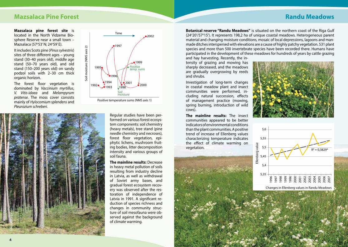
Mazsalaca Pine Forest
Mazsalaca pine forest site is located in the North Vidzeme Bio-sphere Reserve near a small town – Mazsalaca (57o53’ N; 24o59’ E). It includes Scots pine (Pinus sylvestris) sites of three different ages – young stand (30–40 years old), middle age stand (50–70 years old), and old stand (150–200 years old) on sandy podzol soils with 2–30 cm thick organic horizon. The forest floor vegetation is dominated by Vaccinium myrtillus, V. Vitis-idaea and Melampyrum pratense. The moss cover consists mainly of Hylocomium splendens and Pleurozium schreberi.
Regular studies have been per-formed on various forest ecosys-tem components: soil chemistry (heavy metals), tree stand (pine needle chemistry and necroses), forest floor vegetation, epi-phytic lichens, mushroom fruit-ing bodies, litter decomposition intensity and various groups of soil fauna. The mainline results: Decrease in heavy metal pollution of soils resulting from industry decline in Latvia, as well as with drawal of Soviet army bases, and gradual forest ecosystem recov-ery was observed after the res-toration of independence of Latvia in 1991. A significant re-duction of species richness and changes in community struc-ture of soil mesofauna were ob-served against the background of climate warming.
Maz
sala
ca p
ines
1992 19931994
1995
1996
1997
1998
1999
20002001
2002
Positive temperature sums (NMS axis 1)
Soil
moi
stur
e (N
MS
axis
2)
Time
Soilmoisture
Positivetemp. sums
Randu Meadows
Botanical reserve “Randu Meadows” is situated on the northern coast of the Riga Gulf (24o20’/57o15’). It represents 198,2 ha of unique coastal meadows. Heterogeneous parent material and changing moisture conditions, mosaic of local depressions, lagoons and man-made ditches interspersed with elevations are a cause of highly patchy vegetation. 531 plant species and more than 500 invertebrate species have been recorded there. Humans have participated in the development of these meadows for hundreds of years by cattle grazing and hay harvesting. Recently, the in-tensity of grazing and mowing has sharply decreased, and the meadows are gradually overgrowing by reeds and shrubs. Investigation of long-term changes in coastal meadow plant and insect communities were performed, in-cluding natural succession, effects of management practice (mowing, spring burning, introduction of wild cows). The mainline results: The insect communities appeared to be better indicators of environmental conditions than the plant communities. A positive trend of increase of Ellenberg values characterizing temperature indicates the effect of climate warming on vegetation.
1996
Elle
nber
g va
lue
5,6
1997
1998
1999
1996
2000
2001
2002
2003
2004
2005
2007
2006
5,55
5,5
5,45
5,4
5,35
R2 = 0,3829*
Changes in Ellenberg values in Randu Meadows
Rand
u M
eado
ws
54
76
Sala
ca R
iver
Salaca River
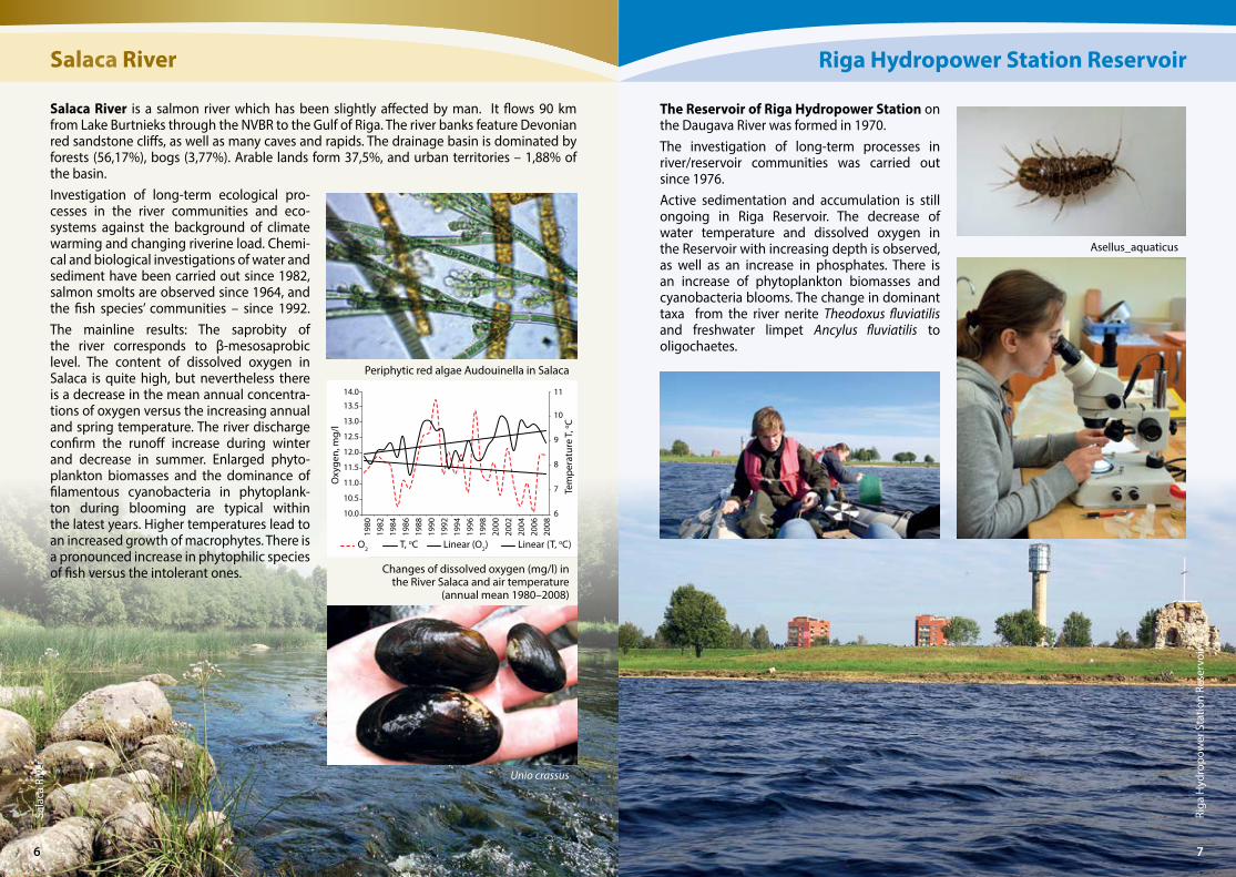
Salaca River is a salmon river which has been slightly affected by man. It flows 90 km from Lake Burtnieks through the NVBR to the Gulf of Riga. The river banks feature Devonian red sandstone cliffs, as well as many caves and rapids. The drainage basin is dominated by forests (56,17%), bogs (3,77%). Arable lands form 37,5%, and urban territories – 1,88% of the basin. Investigation of long-term ecological pro-cesses in the river communities and eco-systems against the background of climate warming and changing riverine load. Chemi-cal and biological investigations of water and sediment have been carried out since 1982, salmon smolts are observed since 1964, and the fish species’ communities – since 1992. The mainline results: The saprobity of the river corresponds to β-mesosaprobic level. The content of dissolved oxygen in Salaca is quite high, but nevertheless there is a decrease in the mean annual concentra-tions of oxygen versus the increasing annual and spring temperature. The river discharge confirm the runoff increase during winter and decrease in summer. Enlarged phyto-plankton biomasses and the dominance of filamentous cyanobacteria in phytoplank-ton during blooming are typical within the latest years. Higher temperatures lead to an increased growth of macrophytes. There is a pronounced increase in phytophilic species of fish versus the intolerant ones.
Periphytic red algae Audouinella in Salaca
6
7
8
9
10
11
10.0
10.5
11.0
11.5
12.0
12.5
13.0
13.5
14.0
1980
1982
1984
1986
1988
1990
1992
1994
1996
1998
2000
2002
2004
2006
2008
Tem
pera
ture
T, o C
Oxy
gen,
mg/
l
O2 T, oC Linear (O2) Linear (T, oC)
Changes of dissolved oxygen (mg/l) in the River Salaca and air temperature
(annual mean 1980–2008)
Riga
Hyd
ropo
wer
Sta
tion
Rese
rvoi
r
Riga Hydropower Station Reservoir
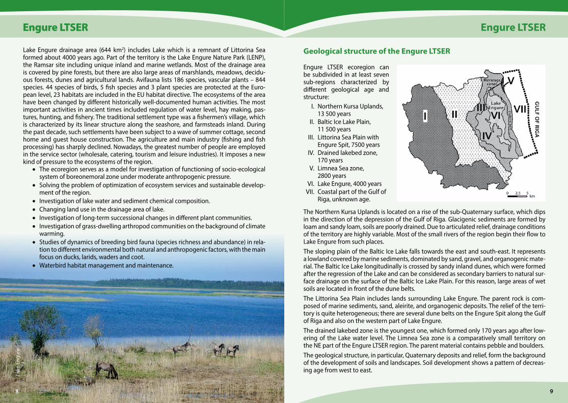
The Reservoir of Riga Hydropower Station on the Daugava River was formed in 1970. The investigation of long-term processes in river/reservoir communities was carried out since 1976.Active sedimentation and accumulation is still ongoing in Riga Reservoir. The decrease of water temperature and dissolved oxygen in the Reservoir with increasing depth is observed, as well as an increase in phosphates. There is an increase of phytoplankton biomasses and cyanobacteria blooms. The change in dominant taxa from the river nerite Theodoxus fluviatilis and freshwater limpet Ancylus fluviatilis to oligochaetes.
Asellus_aquaticus
Unio crassus
76
Engure LTSER
98
Engure LTSEREngure LTSER
Lake Engure drainage area (644 km2) includes Lake which is a remnant of Littorina Sea formed about 4000 years ago. Part of the territory is the Lake Engure Nature Park (LENP), the Ramsar site including unique inland and marine wetlands. Most of the drainage area is covered by pine forests, but there are also large areas of marshlands, meadows, decidu-ous forests, dunes and agricultural lands. Avifauna lists 186 species, vascular plants – 844 species. 44 species of birds, 5 fish species and 3 plant species are protected at the Euro-pean level, 23 habitats are included in the EU habitat directive. The ecosystems of the area have been changed by different historically well-documented human activities. The most important activities in ancient times included regulation of water level, hay making, pas-tures, hunting, and fishery. The traditional settlement type was a fishermen’s village, which is characterized by its linear structure along the seashore, and farmsteads inland. During the past decade, such settlements have been subject to a wave of summer cottage, second home and guest house construction. The agriculture and main industry (fishing and fish processing) has sharply declined. Nowadays, the greatest number of people are employed in the service sector (wholesale, catering, tourism and leisure industries). It imposes a new kind of pressure to the ecosystems of the region.
• The ecoregion serves as a model for investigation of functioning of socio-ecological system of boreonemoral zone under moderate anthropogenic pressure.
• Solving the problem of optimization of ecosystem services and sustainable develop-ment of the region.
• Investigation of lake water and sediment chemical composition. • Changing land use in the drainage area of lake. • Investigation of long-term successional changes in different plant communities. • Investigation of grass-dwelling arthropod communities on the background of climate
warming. • Studies of dynamics of breeding bird fauna (species richness and abundance) in rela-
tion to different environmental both natural and anthropogenic factors, with the main focus on ducks, larids, waders and coot.
• Waterbird habitat management and maintenance.
Lake
Eng
ure
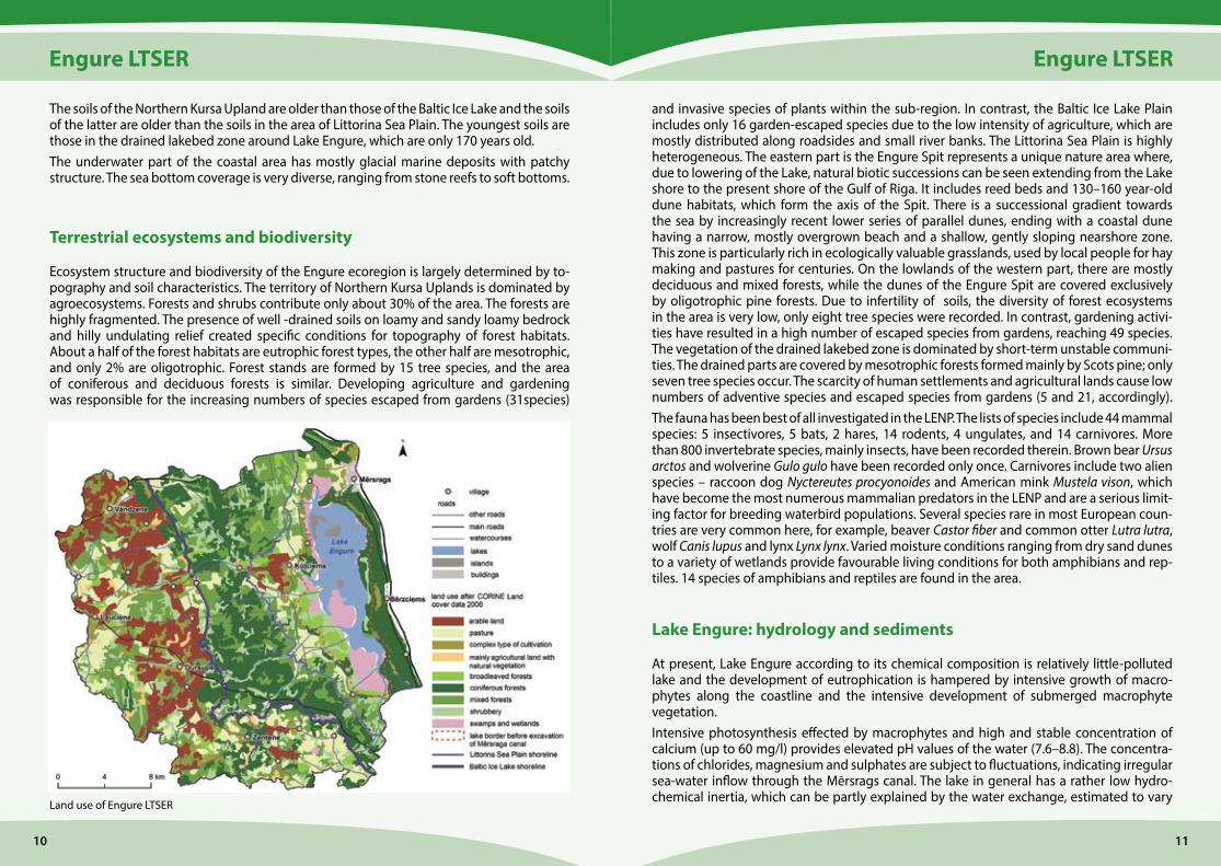
Geological structure of the Engure LTSER
Engure LTSER ecoregion can be sub divided in at least seven sub-regions characterized by different geological age and structure: I. Northern Kursa Uplands,
13 500 years II. Baltic Ice Lake Plain,
11 500 years III. Littorina Sea Plain with
Engure Spit, 7500 years IV. Drained lakebed zone,
170 years V. Limnea Sea zone,
2800 years VI. Lake Engure, 4000 years VII. Coastal part of the Gulf of
Riga, unknown age.
The Northern Kursa Uplands is located on a rise of the sub-Quaternary surface, which dips in the direction of the depression of the Gulf of Riga. Glacigenic sediments are formed by loam and sandy loam, soils are poorly drained. Due to articulated relief, drainage conditions of the territory are highly variable. Most of the small rivers of the region begin their flow to Lake Engure from such places. The sloping plain of the Baltic Ice Lake falls towards the east and south-east. It represents a lowland covered by marine sediments, dominated by sand, gravel, and organogenic mate-rial. The Baltic Ice Lake longitudinally is crossed by sandy inland dunes, which were formed after the regression of the Lake and can be considered as secondary barriers to natural sur-face drainage on the surface of the Baltic Ice Lake Plain. For this reason, large areas of wet soils are located in front of the dune belts. The Littorina Sea Plain includes lands surrounding Lake Engure. The parent rock is com-posed of marine sediments, sand, aleirite, and organogenic deposits. The relief of the terri-tory is quite heterogeneous; there are several dune belts on the Engure Spit along the Gulf of Riga and also on the western part of Lake Engure.The drained lakebed zone is the youngest one, which formed only 170 years ago after low-ering of the Lake water level. The Limnea Sea zone is a comparatively small territory on the NE part of the Engure LTSER region. The parent material contains pebble and boulders. The geological structure, in particular, Quaternary deposits and relief, form the background of the development of soils and landscapes. Soil development shows a pattern of decreas-ing age from west to east.
8
Engure LTSER
1110
Engure LTSER
The soils of the Northern Kursa Upland are older than those of the Baltic Ice Lake and the soils of the latter are older than the soils in the area of Littorina Sea Plain. The youngest soils are those in the drained lakebed zone around Lake Engure, which are only 170 years old. The underwater part of the coastal area has mostly glacial marine deposits with patchy structure. The sea bottom coverage is very diverse, ranging from stone reefs to soft bottoms.
Terrestrial ecosystems and biodiversity
Ecosystem structure and biodiversity of the Engure ecoregion is largely determined by to-pography and soil characteristics. The territory of Northern Kursa Uplands is dominated by agroecosystems. Forests and shrubs contribute only about 30% of the area. The forests are highly fragmented. The presence of well -drained soils on loamy and sandy loamy bedrock and hilly undulating relief created specific conditions for topography of forest habitats. About a half of the forest habitats are eutrophic forest types, the other half are mesotrophic, and only 2% are oligotrophic. Forest stands are formed by 15 tree species, and the area of coniferous and deciduous forests is similar. Developing agriculture and gardening was responsible for the increasing numbers of species escaped from gardens (31species)
Land use of Engure LTSER
and invasive species of plants within the sub-region. In contrast, the Baltic Ice Lake Plain includes only 16 garden-escaped species due to the low intensity of agriculture, which are mostly distributed along roadsides and small river banks. The Littorina Sea Plain is highly heterogeneous. The eastern part is the Engure Spit represents a unique nature area where, due to lowering of the Lake, natural biotic successions can be seen extending from the Lake shore to the present shore of the Gulf of Riga. It includes reed beds and 130–160 year-old dune habitats, which form the axis of the Spit. There is a successional gradient towards the sea by increasingly recent lower series of parallel dunes, ending with a coastal dune having a narrow, mostly overgrown beach and a shallow, gently sloping nearshore zone. This zone is particularly rich in ecologically valuable grasslands, used by local people for hay making and pastures for centuries. On the lowlands of the western part, there are mostly deciduous and mixed forests, while the dunes of the Engure Spit are covered exclusively by oligo trophic pine forests. Due to infertility of soils, the diversity of forest ecosystems in the area is very low, only eight tree species were recorded. In contrast, gardening activi-ties have resulted in a high number of escaped species from gardens, reaching 49 species. The vegetation of the drained lakebed zone is dominated by short-term unstable communi-ties. The drained parts are covered by mesotrophic forests formed mainly by Scots pine; only seven tree species occur. The scarcity of human settlements and agricultural lands cause low numbers of adventive species and escaped species from gardens (5 and 21, accordingly). The fauna has been best of all investigated in the LENP. The lists of species include 44 mammal species: 5 insectivores, 5 bats, 2 hares, 14 rodents, 4 ungulates, and 14 carnivores. More than 800 invertebrate species, mainly insects, have been recorded therein. Brown bear Ursus arctos and wolverine Gulo gulo have been recorded only once. Carnivores include two alien species – raccoon dog Nyctereutes procyonoides and American mink Mustela vison, which have become the most numerous mammalian predators in the LENP and are a serious limit-ing factor for breeding waterbird populations. Several species rare in most European coun-tries are very common here, for example, beaver Castor fiber and common otter Lutra lutra, wolf Canis lupus and lynx Lynx lynx. Varied moisture conditions ranging from dry sand dunes to a variety of wetlands provide favourable living conditions for both amphibians and rep-tiles. 14 species of amphibians and reptiles are found in the area.
Lake Engure: hydrology and sediments
At present, Lake Engure according to its chemical composition is relatively little-polluted lake and the development of eutrophication is hampered by intensive growth of macro-phytes along the coastline and the intensive development of submerged macrophyte vegetation.Intensive photosynthesis effected by macrophytes and high and stable concentration of calcium (up to 60 mg/l) provides elevated pH values of the water (7.6–8.8). The concentra-tions of chlorides, magnesium and sulphates are subject to fluctuations, indicating irregular sea-water inflow through the Mērsrags canal. The lake in general has a rather low hydro-chemical inertia, which can be partly explained by the water exchange, estimated to vary
Engure LTSER
1312
Engure LTSER
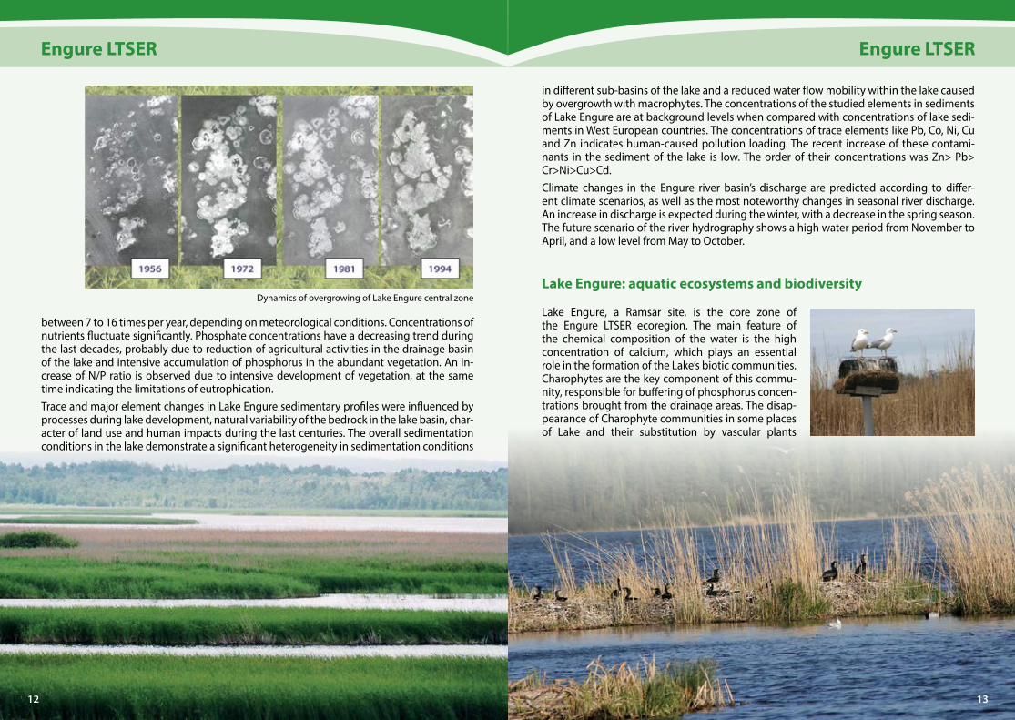
between 7 to 16 times per year, depending on meteorological conditions. Concentrations of nutrients fluctuate significantly. Phosphate concentrations have a decreasing trend during the last decades, probably due to reduction of agricultural activities in the drainage basin of the lake and intensive accumulation of phosphorus in the abundant vegetation. An in-crease of N/P ratio is observed due to intensive development of vegetation, at the same time indicating the limitations of eutrophication.Trace and major element changes in Lake Engure sedimentary profiles were influenced by processes during lake development, natural variability of the bedrock in the lake basin, char-acter of land use and human impacts during the last centuries. The overall sedimentation conditions in the lake demonstrate a significant heterogeneity in sedimentation conditions
Dynamics of overgrowing of Lake Engure central zone
in different sub-basins of the lake and a reduced water flow mobility within the lake caused by overgrowth with macrophytes. The concentrations of the studied elements in sediments of Lake Engure are at background levels when compared with concentrations of lake sedi-ments in West European countries. The concentrations of trace elements like Pb, Co, Ni, Cu and Zn indicates human-caused pollution loading. The recent increase of these contami-nants in the sediment of the lake is low. The order of their concentrations was Zn> Pb> Cr>Ni>Cu>Cd.Climate changes in the Engure river basin’s discharge are predicted according to differ-ent climate scenarios, as well as the most noteworthy changes in seasonal river discharge. An increase in discharge is expected during the winter, with a decrease in the spring season. The future scenario of the river hydrography shows a high water period from November to April, and a low level from May to October.
Lake Engure: aquatic ecosystems and biodiversity
Lake Engure, a Ramsar site, is the core zone of the Engure LTSER ecoregion. The main feature of the chemical composition of the water is the high concentration of calcium, which plays an essential role in the formation of the Lake’s biotic communities. Charophytes are the key component of this commu-nity, responsible for buffering of phosphorus concen-trations brought from the drainage areas. The disap-pearance of Charophyte communities in some places of Lake and their substitution by vascular plants
1312
Engure LTSER
1514
Engure LTSER
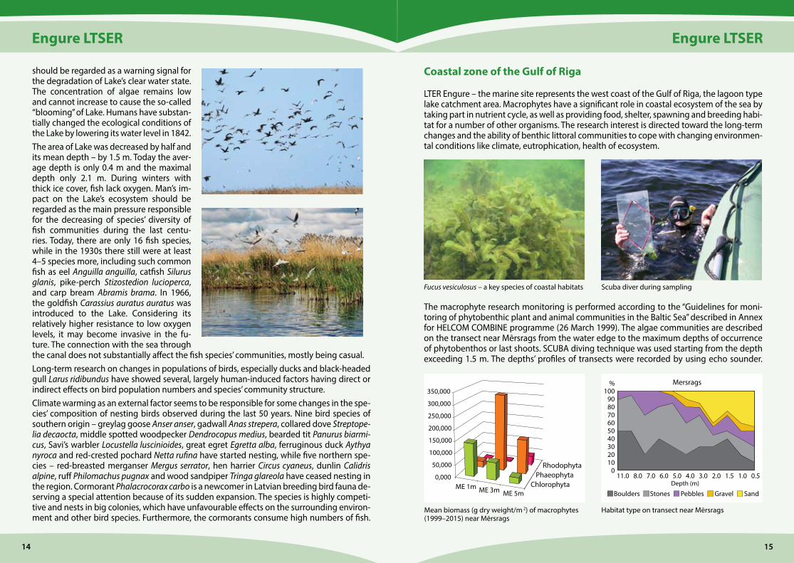
should be regarded as a warning signal for the degradation of Lake’s clear water state. The concentration of algae remains low and cannot increase to cause the so-called “blooming” of Lake. Humans have substan-tially changed the ecological conditions of the Lake by lowering its water level in 1842. The area of Lake was decreased by half and its mean depth – by 1.5 m. Today the aver-age depth is only 0.4 m and the maximal depth only 2.1 m. During winters with thick ice cover, fish lack oxygen. Man’s im-pact on the Lake’s ecosystem should be regarded as the main pressure responsible for the decreasing of species’ diversity of fish communities during the last centu-ries. Today, there are only 16 fish species, while in the 1930s there still were at least 4–5 species more, including such common fish as eel Anguilla anguilla, catfish Silurus glanis, pike-perch Stizostedion lucioperca, and carp bream Abramis brama. In 1966, the goldfish Carassius auratus auratus was introduced to the Lake. Considering its relatively higher resistance to low oxygen levels, it may become invasive in the fu-ture. The connection with the sea through the canal does not substantially affect the fish species’ communities, mostly being casual.Long-term research on changes in populations of birds, especially ducks and black-headed gull Larus ridibundus have showed several, largely human-induced factors having direct or indirect effects on bird population numbers and species’ community structure.Climate warming as an external factor seems to be responsible for some changes in the spe-cies’ composition of nesting birds observed during the last 50 years. Nine bird species of southern origin – greylag goose Anser anser, gadwall Anas strepera, collared dove Streptope-lia decaocta, middle spotted woodpecker Dendrocopus medius, bearded tit Panurus biarmi-cus, Savi’s warbler Locustella luscinioides, great egret Egretta alba, ferruginous duck Aythya nyroca and red-crested pochard Netta rufina have started nesting, while five northern spe-cies – red-breasted merganser Mergus serrator, hen harrier Circus cyaneus, dunlin Calidris alpine, ruff Philomachus pugnax and wood sandpiper Tringa glareola have ceased nesting in the region. Cormorant Phalacrocorax carbo is a newcomer in Latvian breeding bird fauna de-serving a special attention because of its sudden expansion. The species is highly competi-tive and nests in big colonies, which have unfavourable effects on the surrounding environ-ment and other bird species. Furthermore, the cormorants consume high numbers of fish.
Coastal zone of the Gulf of Riga
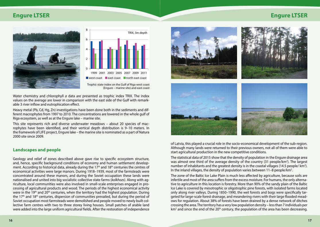
LTER Engure – the marine site represents the west coast of the Gulf of Riga, the lagoon type lake catchment area. Macrophytes have a significant role in coastal ecosystem of the sea by taking part in nutrient cycle, as well as providing food, shelter, spawning and breeding habi-tat for a number of other organisms. The research interest is directed toward the long-term changes and the ability of benthic littoral communities to cope with changing environmen-tal conditions like climate, eutrophication, health of ecosystem.
The macrophyte research monitoring is performed according to the “Guidelines for moni-toring of phytobenthic plant and animal communities in the Baltic Sea” described in Annex for HELCOM COMBINE programme (26 March 1999). The algae communities are described on the transect near Mērsrags from the water edge to the maximum depths of occurrence of phytobenthos or last shoots. SCUBA diving technique was used starting from the depth exceeding 1.5 m. The depths’ profiles of transects were recorded by using echo sounder.
Scuba diver during samplingFucus vesiculosus – a key species of coastal habitats
ME 1m ME 3m ME 5mChlorophyta
PhaeophytaRhodophyta
0,000
50,000
100,000
150,000
200,000
250,000
300,000
350,000
Habitat type on transect near Mērsrags
0102030405060
11.0
708090
100
8.0 7.0 6.0 5.0 4.0 3.0 2.0 1.5 1.0 0.5
Mersrags%
Depth (m)
SandGravelPebblesStonesBoulders
Mean biomass (g dry weight/m 2) of macrophytes (1999–2015) near Mērsrags
Engure LTSER
1716
Engure LTSER
Water chemistry and chlorophyll a data are presented as trophic index TRIX. The index values on the average are lower in comparison with the east side of the Gulf with remark-able 3 river inflow and eutrophication effect.Heavy metal (Pb, Cd, Hg, Zn) investigations have been done both in the sediments and dif-ferent macrophytes from 1997 to 2010. The concentrations are lowered in the whole gulf of Riga ecosystem, as well as at the Engure lake – marine site. This site represents rich and diverse underwater meadows – about 20 species of mac-rophytes have been identified, and their vertical depth distribution is 9–10 meters. In the framework of LIFE project, Engure lake – the marine site is nominated as a part of Natura 2000 site since 2009.
Landscapes and people
Geology and relief of zones described above gave rise to specific ecosystem structure, and, hence, specific background conditions of economy and human settlement develop-ment. According to historical data, already during the 17th and 18th centuries the centres of economical activities were large manors. During 1918–1939, most of the farmsteads were concentrated around these manors, and during the Soviet occupation these lands were nationalised and united into big socialistic collective state farms (kolkhozs). Along with ag-riculture, local communities were also involved in small-scale enterprises engaged in pro-cessing of agricultural products and wood. The periods of the highest economical activity were in the 19th and 20th centuries, when the territory had the highest population. During the 17th and 18th centuries, dispersion of communities prevailed, but during the period of Soviet occupation most farmsteads were demolished and people moved to newly built col-lective farm centres with two to three storey living houses. Small patches of arable land were added into the large uniform agricultural fields. After the restoration of independence
1999 2001 2003 2005 2007 20112009
8
6
4
2
0
TRIX, 3m depth
west coast east coast north east coast
Trophic state index on the Gulf of Riga west coast (Engure – marine site) and east coast
of Latvia, this played a crucial role in the socio-economical development of the sub-region. Although many lands were returned to their previous owners, not all of them were able to start agricultural production in the new competitive conditions. The statistical data of 2015 show that the density of population in the Engure drainage area was almost one third of the average density of the country (31 people/km2). The largest number of inhabitants and the greatest density is in the coastal villages (14.5 people/ km2). In the inland villages, the density of population varies between 11–8 people/km2. The zone of the Baltic Ice Lake Plain is much less affected by agriculture, because soils are infertile and most of the area suffers from the excess moisture. For humans, the only alterna-tive to agriculture in this location is forestry. More than 90% of the sandy plain of the Baltic Ice Lake is covered by mesotrophic or oligotrophic pine forests, with isolated farms located only along river valleys. During 1850–1990, the wet forests and bogs were specifically tar-geted for large-scale forest drainage, and meandering rivers with their large flooded mead-ows for regulation. About 38% of forests have been drained by a dense network of ditches crossing the area. The territory has a very low population density – less than 7 individuals per km2 and since the end of the 20th century, the population of the area has been decreasing.
Engure LTSER
1918
Engure LTSER
Even the previously existing small areas of agricultural lands are now abandoned and af-forestation of the region has increased by 14% since the 20th century.Human settlements are concentrated mostly on the eastern coastal part of the Engure Spit. Unlike the other areas, this has been subjected to a much heavier human pressure. During 1850–1990, the coastal area has been developing as a row of fisherman’s villages. There were no agricultural fields, except small gardens around houses. At present, on the western part of Lake economic activities are decreasing along with the population size, and on the coastal part of the sea construction of buildings increases despite of the fact that fishing and fish processing gradually declined since the early century due to the new EU fishing regulations. Active building of summer houses and small hotels now takes place in the coastal area, consequently, the forest areas have decreased by 3%.
Conceptual model of the Engure LTSER
In the framework of the large scale national research project, a conceptual integrated model of the Engure LTSER was developed on the basis of DPSIR (Drivers-Pressures-States- Impacts-Responses) concept. The Engure ecoregion was subdivided into seven sub- regions, mostly demarcated by geological and geographical barriers. Each sub-region has a specific ecosystem structure and elements of biodiversity. The analysis of governing drivers and pressures was performed separately for each sub-region during three time periods:
1. the 19th century – the beginning of the 20th century, 2. the period of Soviet occupation (1940–1991), 3. period after restoration of independence of Latvia (1991 – today).
The 1st period can be characterized by extensive and widespread agriculture. The territory was subjected to strong deforestation, because wood was widely used not only for building construction, but also for heating, iron ore smelting, production of wood-derived tar and charcoal. The increase in population numbers and shortage of lands was the main reason why Lake Engure water level was lowered in 1842 by digging the Mērsrags Canal. Agricul-tural practices of the estates and private farms were quite environmentally friendly, except at the end of the period, when modern methods of farming started to spread among farm-steads, including a more extensive use of artificial fertilizers. The 2nd period can be characterized by devastating attitude to natural resources. Private lands were taken away from the owners and merged in big collective farms (kolkhozs), and the people from single farmsteads were concentrated in village centres of these collective farms. Artificial fertilizers and pesticides were used in large quantities, causing pollution of soils and rivers. The 3rd period is characterized by a decrease in human pressure on the eco-systems of Latvia. After the restoration of independence, a major restructuring took place in the state policy and economy. Because of significant reduction in industry and removal of Soviet military bases, local environmental pollution decreased. Non-economic use of fertilizers and pesticides was stopped in line with land privatization. However, many new
landowners and farmers soon discovered that they could not provide agricultural products to the market, retaining competitive prices. It turned out to be unprofitable to rise cattle and produce milk even for their own use. Many fields and farms were abandoned and over-grew with secondary forest. Based on the conceptual model, two alternative scenarios of the development of the Engure ecoregion are discussed: (i) depopulation and land abandonment, and (ii) intensification of agriculture, small-scale industry and building construction. In both cases, the present state of ecosystems and biodiversity would be subjected to a significant change. A sustainable development of the ecoregion can be provided only by implementing certain environmen-tal management measures accompanied by long-term socio-ecological research and eco-logical monitoring.
Long-term ecoLogicaL research in Latvia
Project team: Viesturs Melecis, Gunta Spriņģe, Māris Kļaviņš, Ivars Strautnieks, Zanda Penēze, Zaiga Krišjāne
Photos: Aina Karpa, Ināra Melece, Ivars Druvietis, Ivars Strautnieks, Ineta Grīne, Egita Zviedre, Solvita Rūsiņa, Agnese Priede, Māris Kļaviņš
English editor: Andra DambergaLayout: Andra Liepiņa
Publisher: University of Latvia PressPrinted: SIA “Latgales druka”
9 7 8 9 9 3 4 1 8 1 6 0 3
ISBN 978-9934-18-160-3
© University of Latvia, 2016