Embed Size (px)
Citation preview
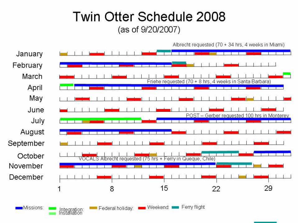
Controlled Towed Vehicle Controlled Towed Vehicle (CTV)(CTV)
Djamal Khelif & Carl Friehe, University of California, Irvine, CA Bob Bluth & Haf Jonsson, CIRPAS, Naval Postgraduate School, Monterey, CA Jesse Barge, Dan Bierly & Todd Morse, Zivko Aeronautics Inc., Guthrie, OKLarry Mahrt, NWRA Bellevue, Washington
A new aircraft-towed platform for air-sea interaction measurements
ONR SBIR and ONR Marine Meteorology
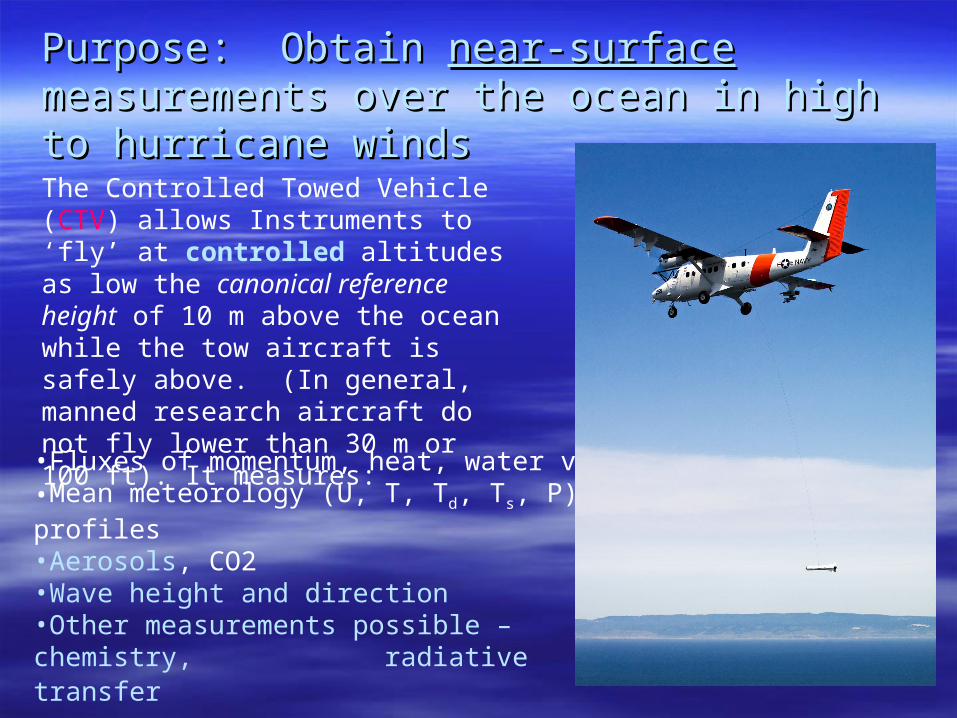
Purpose: Obtain Purpose: Obtain near-surfacenear-surface measurements measurements over the ocean in high to hurricane windsover the ocean in high to hurricane winds
•Fluxes of momentum, heat, water vapor•Mean meteorology (U, T, Td, Ts, P) & profiles•Aerosols, CO2•Wave height and direction•Other measurements possible – chemistry, radiative transfer
The Controlled Towed Vehicle (CTV) allows Instruments to ‘fly’ at controlled altitudes as low the canonical reference height of 10 m above the ocean while the tow aircraft is safely above. (In general, manned research aircraft do not fly lower than 30 m or 100 ft). It measures:
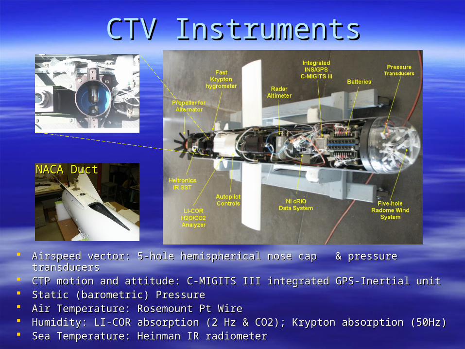
Airspeed vector: 5-hole hemispherical nose cap & pressure transducersAirspeed vector: 5-hole hemispherical nose cap & pressure transducers CTP motion and attitude: C-MIGITS III integrated GPS-Inertial unitCTP motion and attitude: C-MIGITS III integrated GPS-Inertial unit Static (barometric) PressureStatic (barometric) Pressure Air Temperature: Rosemount Pt WireAir Temperature: Rosemount Pt Wire Humidity: LI-COR absorption (2 Hz & CO2); Krypton absorption (50Hz)Humidity: LI-COR absorption (2 Hz & CO2); Krypton absorption (50Hz) Sea Temperature: Heinman IR radiometerSea Temperature: Heinman IR radiometer
CTV InstrumentsCTV Instruments
NACA DuctNACA Duct
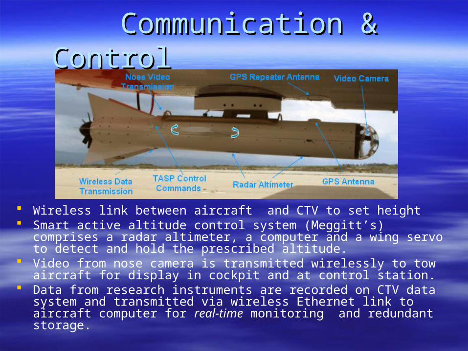
Wireless link between aircraft and CTV to set height Smart active altitude control system (Meggitt’s) comprises a radar
altimeter, a computer and a wing servo to detect and hold the prescribed altitude.
Video from nose camera is transmitted wirelessly to tow aircraft for display in cockpit and at control station.
Data from research instruments are recorded on CTV data system and transmitted via wireless Ethernet link to aircraft computer for real-time monitoring and redundant storage.
Communication & ControlCommunication & Control
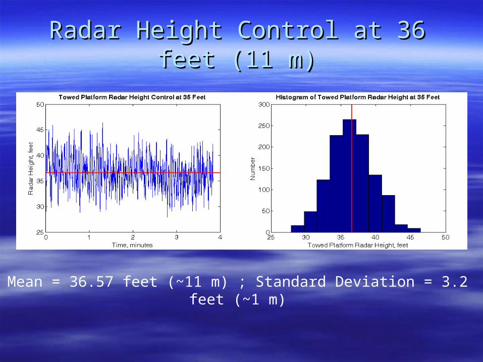
Radar Height Control at 36 feet (11 m)Radar Height Control at 36 feet (11 m)
Mean = 36.57 feet (~11 m) ; Standard Deviation = 3.2 feet (~1 m)
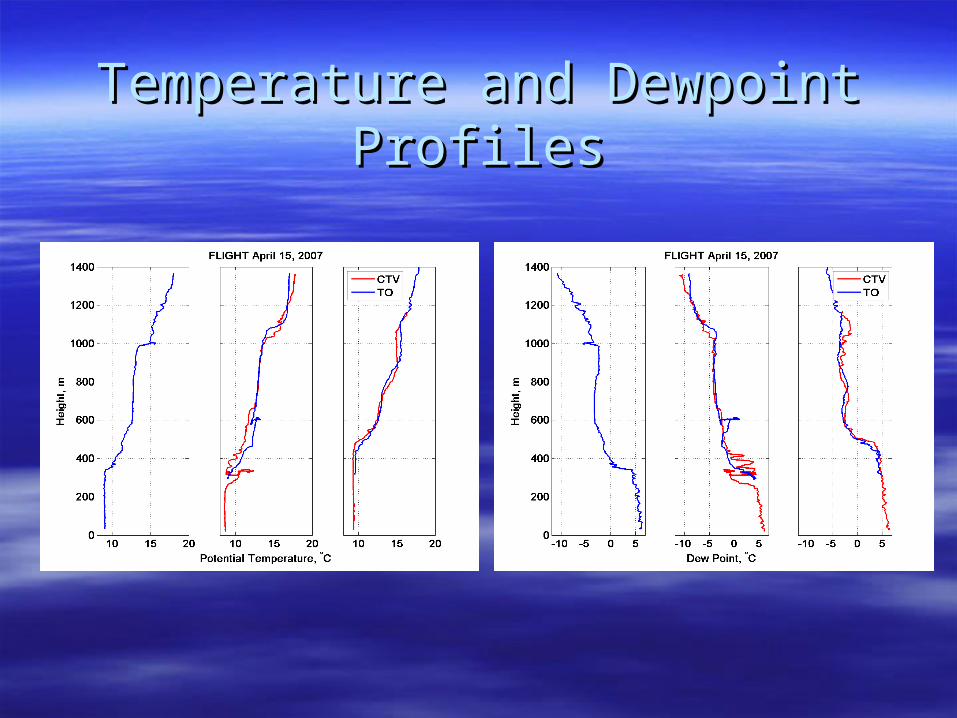
Temperature and Dewpoint ProfilesTemperature and Dewpoint Profiles
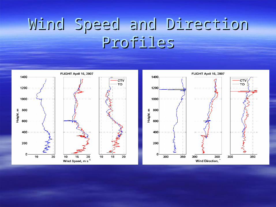
Wind Speed and Direction ProfilesWind Speed and Direction Profiles
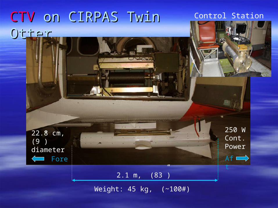
CTVCTV on CIRPAS Twin Otter on CIRPAS Twin Otter
Fore Aft
Control Station
22.8 cm, (9”) diameter
Weight: 45 kg, (~100#)
250 WCont.Power
2.1 m, (83”)
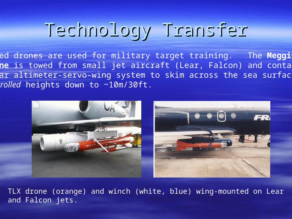
Technology TransferTechnology TransferTowed drones are used for military target training. The Meggitt TLX drone is towed from small jet aircraft (Lear, Falcon) and contains a radar altimeter-servo-wing system to skim across the sea surface at controlled heights down to ~10m/30ft.
TLX drone (orange) and winch (white, blue) wing-mounted on Lear and Falcon jets.
ConclusionsConclusions
MABL mean and turbulence measurements as low as 10 m. This was MABL mean and turbulence measurements as low as 10 m. This was only possible from surface platforms (FLIP, ships, ASIT, spar buoys) only possible from surface platforms (FLIP, ships, ASIT, spar buoys) BUT these lack the spatial coverage aircraft have. BUT these lack the spatial coverage aircraft have.
Simultaneous measurements from two different heights inside the Simultaneous measurements from two different heights inside the MABL or with aircraft in/above clouds and CTV below/in clouds, MABL or with aircraft in/above clouds and CTV below/in clouds, respectively (useful to clouds dynamics and processes studies.) respectively (useful to clouds dynamics and processes studies.)
Simultaneous measurements of surface fluxes and wave field Simultaneous measurements of surface fluxes and wave field mapping/imaging would be possible from aircraft during experiments mapping/imaging would be possible from aircraft during experiments focusing on wind forcing and wave field coupling such as GOTEX focusing on wind forcing and wave field coupling such as GOTEX (NSF/NCAR C130) with the bonus of optimized flight time.(NSF/NCAR C130) with the bonus of optimized flight time.
CTV may be an alternative to the very likely curtailment of low-level CTV may be an alternative to the very likely curtailment of low-level boundary-layer flights with NOAA P3s due to recent operational boundary-layer flights with NOAA P3s due to recent operational problems attributed to sea salt contamination of the engines during problems attributed to sea salt contamination of the engines during low flights in hurricanes.low flights in hurricanes.
The results obtained from the newly developed CTV indicate that The results obtained from the newly developed CTV indicate that
research aircraft will have enhanced capabilities such as:research aircraft will have enhanced capabilities such as:


![A PHP Error was encountered - CIRPAS InifapPDF-1.5 %µµµµ 1 0 obj >>> endobj 2 0 obj > endobj 3 0 obj >/ExtGState >/XObject >/ProcSet[/PDF/Text/ImageB/ImageC/ImageI] >>/MediaBox[](https://img.pdfslide.net/doc/110x75/5c9058e309d3f2dc088d128f/a-php-error-was-encountered-cirpas-pdf-15-1-0-obj-endobj-2-0-obj.jpg)
![Publications - · [11] Bassem Makni, Khaled Khelif, Rose Dieng-Kuntz, and Hac`ene Cherfi. Utilisation du Web S´emantique pour la gestion d’une liste de diffusion d’une CoP](https://img.pdfslide.net/doc/110x75/5f0583647e708231d41355af/publications-11-bassem-makni-khaled-khelif-rose-dieng-kuntz-and-hacene-cheri.jpg)