Embed Size (px)
Citation preview
1
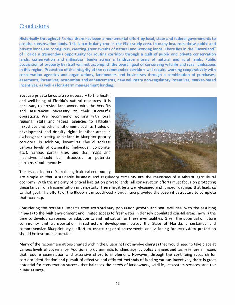
Photo by Carlton Ward Jr. Cooperative Conservation Blueprint Regional Pilot Project
A Strategic Approach Toward
Regional Conservation Connectivity
Prepared by Kimball Love Photos by Carlton Ward Jr. and the FWC
2013
2
Table of Contents Acronyms ...................................................................................................................................................................... 3
Executive Summary ...................................................................................................................................................... 4
Proposed Blueprint Implementation Benchmarks ................................................................................................... 6
Priority Strategic Opportunity Areas ........................................................................................................................ 7
Summary of Potential Blueprint Partnering and Project Opportunities .................................................................. 8
Introduction .................................................................................................................................................................. 9
The Blueprint Pilot Project ........................................................................................................................................ 9
Conservation Planning with Continuing Data Development .............................................................................. 11
Stakeholder Involvement and Coordination ....................................................................................................... 12
Incentives for Conservation Funding .................................................................................................................. 14
Moving Forward .......................................................................................................................................................... 16
Continue to Identify and Promote Connectivity ..................................................................................................... 16
Continue to Focus on Interagency Coordination and Buy-In.................................................................................. 16
Continue to Pursue Landowner Involvement ......................................................................................................... 17
Expand Funding Opportunities ............................................................................................................................... 18
Mitigation............................................................................................................................................................ 18
Payments for Ecosystem Services ....................................................................................................................... 19
Gopher Tortoise PES ........................................................................................................................................... 20
A Framework for the Florida Watershed Fund ................................................................................................... 20
Transition to the Peninsular Florida Landscape Conservation Cooperative (PFLCC) ............................................. 21
Strategic Approach ..................................................................................................................................................... 22
Strategic Partnering Opportunities ......................................................................................................................... 22
Blueprint Pilot Priority Strategic Opportunity Areas .............................................................................................. 24
Conclusions ................................................................................................................................................................. 26
APPENDIX I - Southwest Florida Blueprint Study Area Maps ..................................................................................... 27
APPENDIX II - Landowners Assistance Group ............................................................................................................. 31
APPENDIX III - Cooperative Conservation Blueprint Strategic Opportunities with Partners ...................................... 32
APPENDIX IV – Works Referenced .............................................................................................................................. 42
Acronyms
3
AG - Blueprint Landowner Assistance Group NGOs - Non-governmental Organizations
Blueprint - Cooperative Conservation Blueprint NRCS - Natural Resources Conservation Service
CLCP - Center for Landscape Conservation Planning OGT - FDEP Office of Greenways and Trails
CLIP - Critical Lands and Waters Identification Project PES - Payments for Ecosystem Services
Committee - Babcock Ranch Steering Committee PFLCC - Peninsular Florida Landscape Conservation Cooperative
CTF - Conservation Trust for Florida Pilot - Cooperative Conservation Blueprint Regional Pilot Project
DACS - Florida Department of Agriculture and Consumer Services Ridge - Lake Wales Ridge
FDEP - Florida Department of Environmental Protection SFWMD - South Florida Water Management District
FDOT - Florida Department of Transportation TDR - Transfer of development rights
FEGN - Florida Ecological Greenways Network US - United States
FNAI - Florida Natural Areas Inventory USDA – U.S. Department of Agriculture
FWC - Florida Fish and Wildlife Conservation Commission US DOI - U.S. Department of Interior
GIS - Geographic Information Systems USFWS - U.S. Fish and Wildlife Service
LAP - FWC Landowner Assistance Program WMDs -Water Management Districts
NE-PES - Northern Everglades Payment for Ecosystem Services WRP -NRCS Wetlands Reserve Program
4
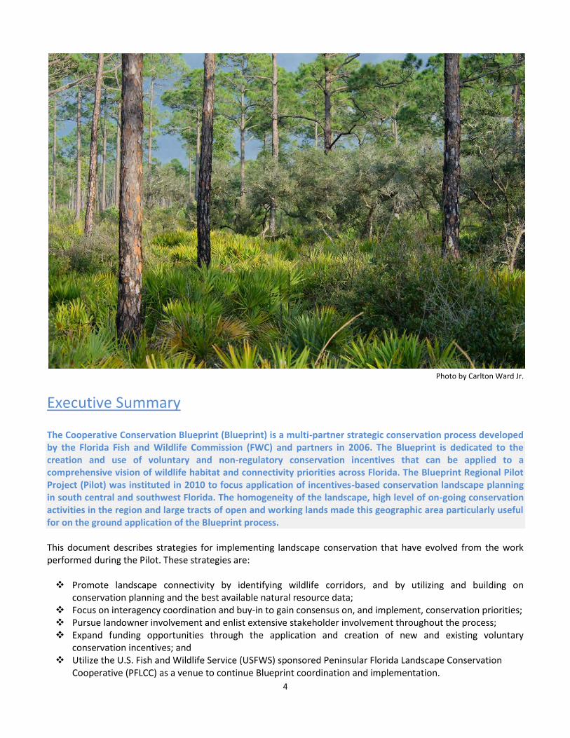
Photo by Carlton Ward Jr.
Executive Summary
The Cooperative Conservation Blueprint (Blueprint) is a multi-partner strategic conservation process developed by the Florida Fish and Wildlife Commission (FWC) and partners in 2006. The Blueprint is dedicated to the creation and use of voluntary and non-regulatory conservation incentives that can be applied to a comprehensive vision of wildlife habitat and connectivity priorities across Florida. The Blueprint Regional Pilot Project (Pilot) was instituted in 2010 to focus application of incentives-based conservation landscape planning in south central and southwest Florida. The homogeneity of the landscape, high level of on-going conservation activities in the region and large tracts of open and working lands made this geographic area particularly useful for on the ground application of the Blueprint process.
This document describes strategies for implementing landscape conservation that have evolved from the work performed during the Pilot. These strategies are:
Promote landscape connectivity by identifying wildlife corridors, and by utilizing and building on conservation planning and the best available natural resource data;
Focus on interagency coordination and buy-in to gain consensus on, and implement, conservation priorities; Pursue landowner involvement and enlist extensive stakeholder involvement throughout the process; Expand funding opportunities through the application and creation of new and existing voluntary
conservation incentives; and Utilize the U.S. Fish and Wildlife Service (USFWS) sponsored Peninsular Florida Landscape Conservation
Cooperative (PFLCC) as a venue to continue Blueprint coordination and implementation.
5
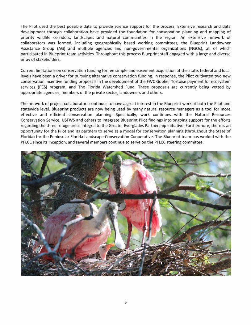
The Pilot used the best possible data to provide science support for the process. Extensive research and data development through collaboration have provided the foundation for conservation planning and mapping of priority wildlife corridors, landscapes and natural communities in the region. An extensive network of collaborators was formed, including geographically based working committees, the Blueprint Landowner Assistance Group (AG) and multiple agencies and non-governmental organizations (NGOs), all of which participated in Blueprint team activities. Throughout this process Blueprint staff engaged with a large and diverse array of stakeholders. Current limitations on conservation funding for fee simple and easement acquisition at the state, federal and local levels have been a driver for pursuing alternative conservation funding. In response, the Pilot cultivated two new conservation incentive funding proposals in the development of the FWC Gopher Tortoise payment for ecosystem services (PES) program, and The Florida Watershed Fund. These proposals are currently being vetted by appropriate agencies, members of the private sector, landowners and others. The network of project collaborators continues to have a great interest in the Blueprint work at both the Pilot and statewide level. Blueprint products are now being used by many natural resource managers as a tool for more effective and efficient conservation planning. Specifically, work continues with the Natural Resources Conservation Service, USFWS and others to integrate Blueprint Pilot findings into ongoing support for the efforts regarding the three refuge areas integral to the Greater Everglades Partnership Initiative. Furthermore, there is an opportunity for the Pilot and its partners to serve as a model for conservation planning (throughout the State of Florida) for the Peninsular Florida Landscape Conservation Cooperative. The Blueprint team has worked with the PFLCC since its inception, and several members continue to serve on the PFLCC steering committee.
6
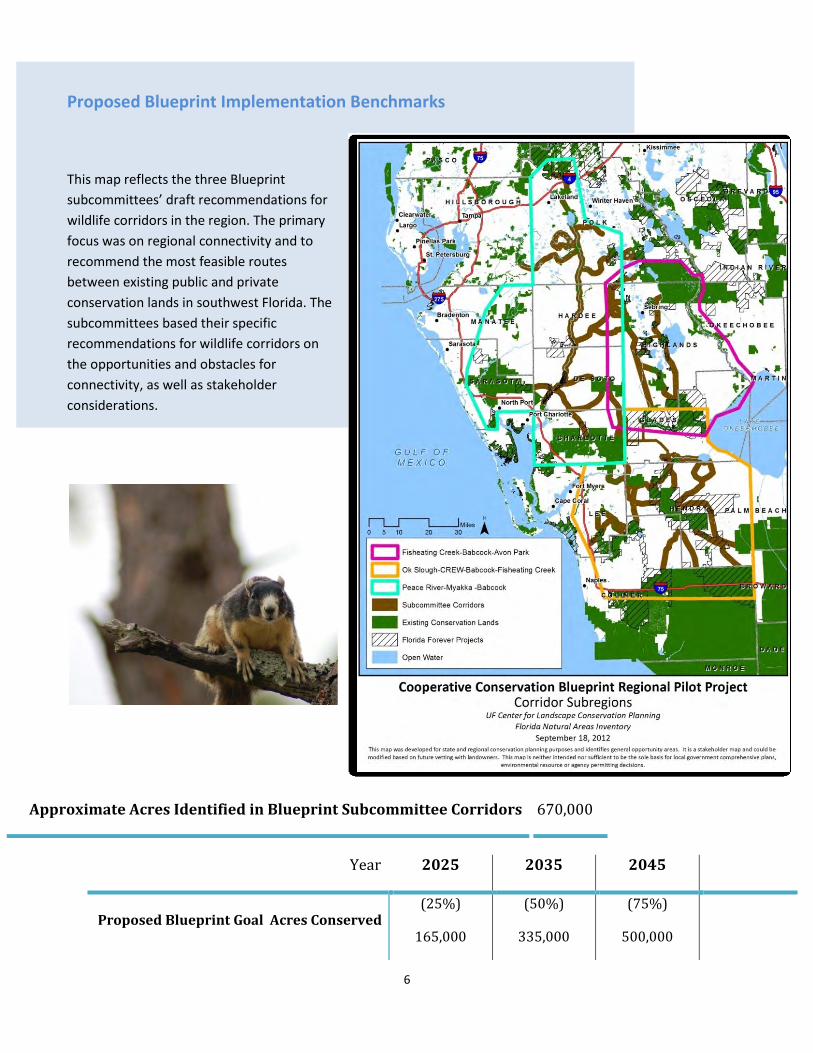
Proposed Blueprint Implementation Benchmarks
This map reflects the three Blueprint
subcommittees’ draft recommendations for
wildlife corridors in the region. The primary
focus was on regional connectivity and to
recommend the most feasible routes
between existing public and private
conservation lands in southwest Florida. The
subcommittees based their specific
recommendations for wildlife corridors on
the opportunities and obstacles for
connectivity, as well as stakeholder
considerations.
Approximate Acres Identified in Blueprint Subcommittee Corridors 670,000
Year 2025 2035 2045
(75%)
500,000 Proposed Blueprint Goal Acres Conserved
(25%)
165,000
(50%)
335,000
7
Photo by Carlton Ward Jr.
Priority Strategic Opportunity Areas
Through the work of the Blueprint in the Pilot region, the following is an initial identification of potential strategic opportunity areas that stand out for near future conservation efforts. It is provided as both a starting point and example for future discussion, with the goal that such identification will continue during follow-up work through the Blueprint or related projects and programs. Provided in no particular order of priority: Proposed Everglades Headwaters Refuge site located across US 27 in southeastern Polk County Corridor crossings across the Caloosahatchee River and especially the Caloosahatchee Ecoscape Florida
Forever Project Peace River-Green Swamp corridor connector and Interstate 4 crossing in northern Polk County US 27 corridor crossing between Smoak Ranch and Archbold Biological Station in southern Highlands County Ecological connectivity between Kissimmee Prairie State Preserve and Three Lakes Wildlife Management Area
and the conservation lands along the upper St. Johns River in Osceola and Okeechobee counties Ranchlands within corridors between Babcock Ranch, Bright Hour conservation easement and the Fisheating
Creek Wetland Reserve Program easements in Charlotte, Desoto, and Highlands counties Areas of parcel fragmentation in corridors between Babcock Ranch-Peace River-Myakka conservation lands
primarily in Desoto County Various Florida Forever projects adjacent to Okaloacoochee Slough State Forest in Hendry and Collier counties Lands between Fisheating Creek Wetland Reserve Program easements and Highlands Hammock State Park in
Highlands County
8
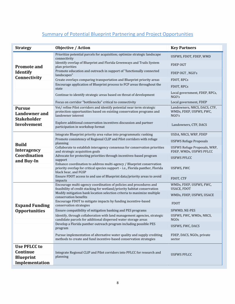
Summary of Potential Blueprint Partnering and Project Opportunities
Strategy Objective / Action Key Partners
Promote and Identify Connectivity
Prioritize potential parcels for acquisition; optimize strategic landscape connectivity
USFWS, FDOT, FDEP, WMD
Identify overlap of Blueprint and Florida Greenways and Trails System plan priorities
FDEP OGT
Promote education and outreach in support of "functionally connected landscapes"
FDEP OGT , NGO’s
Create overlays comparing transportation and Blueprint priority areas FDOT, RPCs
Encourage application of Blueprint process to FCP areas throughout the state
FDOT, RPCs
Continue to identify strategic areas based on threat of development Local government, FDEP, RPCs, NGO’s
Focus on corridor "bottlenecks" critical to connectivity Local government, FDEP
Pursue Landowner and Stakeholder Involvement
Vet/ refine Pilot corridors and identify potential near term strategic protection opportunities based on existing conservation programs and landowner interest
Landowners, NRCS, DACS, CTF, WMDs, FDEP, USFWS, FWC, NGO’s
Explore additional conservation incentives discussion and partner participation in workshop format
Landowners, CTF, DACS
Build Interagency Coordination and Buy-In
Integrate Blueprint priority area value into programmatic ranking USDA, NRCS, WRP, FDEP
Promote consistency of Regional CLIP and Pilot corridors with refuge planning
USFWS Refuge Proposals
Collaborate to establish interagency consensus for conservation priorities and strategic acquisition goals
USFWS Refuge Proposals, WRP, FDEP, WMDs, USFWS PFLCC
Advocate for protecting priorities through incentives-based program support
USFWS PFLCC
Enhance coordination to address multi-agency / Blueprint conservation priority overlap for critical species support – i.e., Florida panther, Florida black bear, and FGSP
USFWS, FWC
Ensure FDOT access to and use of Blueprint data/priority areas to avoid impacts
FDOT, CTF
Expand Funding Opportunities
Encourage multi-agency coordination of policies and procedures and feasibility of credit stacking for wetland/priority habitat conservation
WMDs, FDEP, USFWS, FWC, USACE, FDOT
Modify mitigation bank location selection criteria to maximize multiple conservation benefits
WMDs, FDEP, USFWS, USACE
Encourage FDOT to mitigate impacts by funding incentive-based conservation strategies
FDOT
Ensure compatibility of mitigation banking and PES programs SFWMD, NE-PES
Identify, through collaboration with land management agencies, strategic candidate parcels for additional dispersed water storage areas
USFWS, FWC, WMDs, NRCS, NGOs
Develop a Florida panther outreach program including possible PES program
USFWS, FWC, DACS
Pursue implementation of alternative water quality and supply crediting methods to create and fund incentive-based conservation strategies
FDEP, DACS, NGOs, private sector
Use PFLCC to Continue Blueprint Implementation
Integrate Regional CLIP and Pilot corridors into PFLCC for research and planning
USFWS PFLCC
9
Photo by Carlton Ward Jr.
Introduction The Cooperative Conservation Blueprint (Blueprint) was initiated in 2006 by the Florida Fish and Wildlife Conservation Commission (FWC) as part of the 2005 State Wildlife Action Plan. The Blueprint created a forum for conservation leadership among landowners, businesses, state, local and regional governments, universities, nonprofit organizations and those members of the general public interested in protecting habitat and biodiversity. The purpose of the Blueprint was to develop broad agreement on both voluntary and non-regulatory conservation incentives along with a comprehensive vision of wildlife habitat and connectivity priorities to which existing and new incentive ideas can be applied. The project is built on a science-based identification of priority lands to be conserved for the benefit of human, wildlife and watershed protection. Establishing a landscape-scale context for setting those priorities and providing for a collaborative environment between and among multiple stakeholders, the Blueprint provides for a comprehensive and holistic approach to successful and sustainable conservation decision making. Three creative incentive working groups were established early in the project to pursue the development of landowner incentives related to water, land and energy. Guiding principles were developed by those working groups along with several new incentive ideas. It became clear during this phase of the project that incentives were key to landowner participation and that support of sustainable agriculture is crucial to the success of the Blueprint project1. The science behind the identification of consensus conservation priorities alone cannot complete the mission of the Blueprint. Sustainability of agricultural operations depends on financial viability secured through the creation of “currency” for funding, operations cost reduction or other benefits to landowners such as regulatory certainty and consistency. In order to explore new approaches to that viability, development of Payments for Ecosystem Services (PES) became a focus of the overall Blueprint Project discussions and a keystone for the Blueprint Pilot created in the summer of 2010.
The Blueprint Pilot Project
1 Small, Christine, Morris, Julie, Hoctor, T.S. 2012. Southwest Florida Blueprint Pilot Project Area: 2011 Year-end Summary Report

10
The Pilot was conceived as a method for implementation of the Blueprint guiding principles in a regional context. The south-central and southwest Florida area extending from the Big Cypress National Preserve north to the upper reaches of the Peace and Kissimmee Rivers was selected because the following characteristics make it well-suited for landscape-level conservation planning:
Photo by Carlton Ward Jr.
The landscape and the attendant land uses are relatively homogenous.
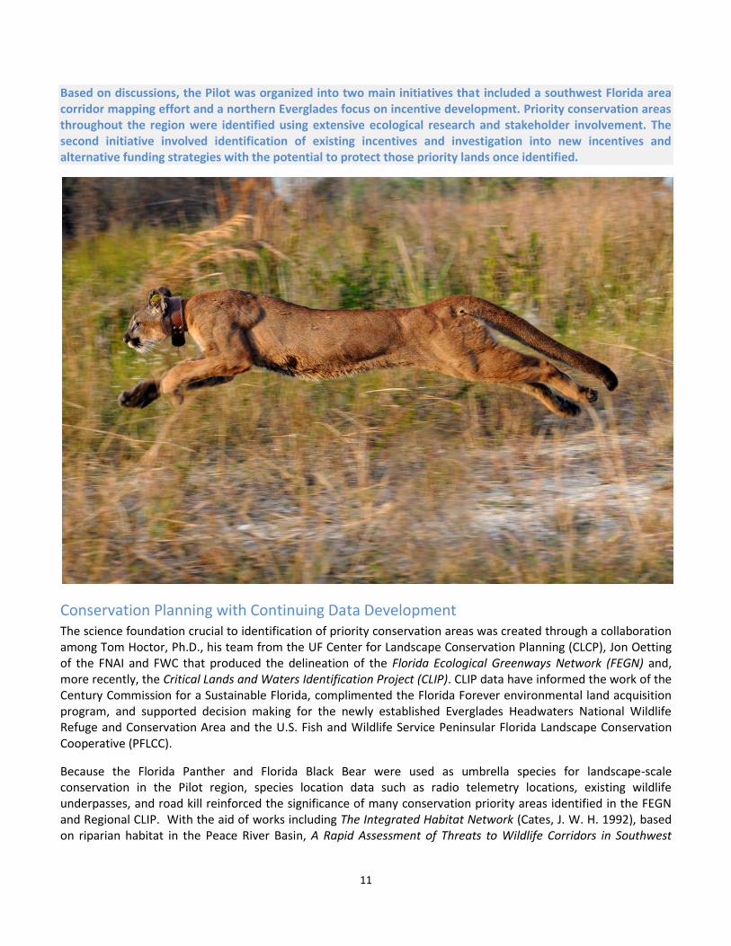
The habitat provides for protection of Florida Panther and Florida Black Bear populations that require large ranges with sparse human activity and serve as umbrella species for conservation of other species that benefit from improved habitat connectivity.
The vast majority of priority conservation areas are within large parcels held by a few landowners, simplifying development of protection agreements for those areas.
Realizing the value of these landowners as partners in the Pilot, the Landowner Assistance Group (AG) was recruited by Blueprint staff in the fall of 2010. Staff members organized and held a series of group and individual meetings with this select group of volunteers to determine necessary considerations for gaining the support of the agricultural community. The AG members are leaders in their respective fields of agricultural production, law or corporate management within the state agricultural community and many of them previously participated in the Blueprint incentive groups (See Appendix II). Familiar with various existing incentive programs, the AG pointed out that the road to success for agriculture and protected habitat must include new and innovative ways to enhance revenue and secure regulatory certainty for participating landowners. Payment for water-based ecosystem services was the number one recommendation by the AG for protecting lands identified through the Blueprint process. The need for a focus on potential water- related services provided by agricultural producers for purposes of conservation, payment for those services and regulatory certainty regarding arrangements for those services was the primary message regarding future collaboration for management of priority lands.
11
Based on discussions, the Pilot was organized into two main initiatives that included a southwest Florida area corridor mapping effort and a northern Everglades focus on incentive development. Priority conservation areas throughout the region were identified using extensive ecological research and stakeholder involvement. The second initiative involved identification of existing incentives and investigation into new incentives and alternative funding strategies with the potential to protect those priority lands once identified.
Conservation Planning with Continuing Data Development The science foundation crucial to identification of priority conservation areas was created through a collaboration among Tom Hoctor, Ph.D., his team from the UF Center for Landscape Conservation Planning (CLCP), Jon Oetting of the FNAI and FWC that produced the delineation of the Florida Ecological Greenways Network (FEGN) and, more recently, the Critical Lands and Waters Identification Project (CLIP). CLIP data have informed the work of the Century Commission for a Sustainable Florida, complimented the Florida Forever environmental land acquisition program, and supported decision making for the newly established Everglades Headwaters National Wildlife Refuge and Conservation Area and the U.S. Fish and Wildlife Service Peninsular Florida Landscape Conservation Cooperative (PFLCC).
Because the Florida Panther and Florida Black Bear were used as umbrella species for landscape-scale conservation in the Pilot region, species location data such as radio telemetry locations, existing wildlife underpasses, and road kill reinforced the significance of many conservation priority areas identified in the FEGN and Regional CLIP. With the aid of works including The Integrated Habitat Network (Cates, J. W. H. 1992), based on riparian habitat in the Peace River Basin, A Rapid Assessment of Threats to Wildlife Corridors in Southwest
12
Florida (Hoctor, T. S., J. Oetting, and M. O'Brien. 2011) and the Regional Assessment of Critical Lands and Waters Identification Project (Regional CLIP), additional data has been incorporated.
The southwest Florida focus was supported by work completed under the auspices of the Babcock Ranch Steering Committee (Babcock Committee) established in 2006 by Kitson and Partners. Kitson and Partners are the developers of Babcock Ranch Florida and were subject to a settlement agreement to develop a regional plan to “protect, enhance and re-establish wildlife corridors”. 2 Extensive background data related to current and projected land use, existing and potential transportation corridors, developments of regional impact, and estimates for sea level rise for the region set the stage for corridor connectivity assessments within the Committee’s final report. Scientific work by Tom Hoctor and Reed Noss addressing the regional habitat and corridor needs for the Florida Black Bear, Florida Panther, and Big Cypress/Sherman’s Fox Squirrels provided the necessary data to outline potential risks to a “moderate connectivity scenario” in an area consistent with the Blueprint Pilot region.
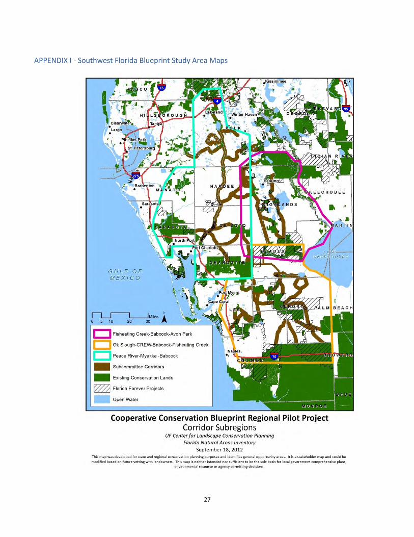
Stakeholder Involvement and Coordination With leadership from several Babcock Committee members and Blueprint staff, it was agreed that the Babcock Committee would continue the delineation of corridor implementation opportunities as members of the new Southwest Florida Blueprint Working Group (Working Group). The Working Group agreed to the task of identifying additional wildlife corridors important for regional ecological connectivity and developing recommendations for voluntary, incentives-based strategies for implementing protection of the identified corridors. With extensive background data related to southwest Florida and an established relationship with the Working Group, the focus on the southwest portion of the overall Blueprint Pilot area effectively began at the Babcock Committee meeting on September 22, 2010. By June of 2011 the Blueprint team organized three Corridor Subcommittees to identify wildlife corridors between existing public conservation lands in Collier, Lee, Hendry, Glades, Highlands, Hardee, DeSoto, Polk and parts of Charlotte, Manatee and Sarasota Counties. Subcommittee designations were based on the geography of three major watersheds including the Peace River, the Caloosahatchee River and Fisheating Creek/Avon Park. They are as follows:
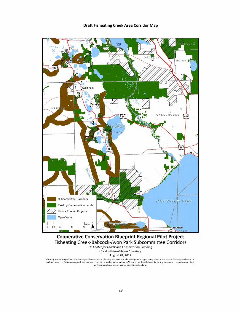
1) The “Fisheating Creek/Avon Park Subcommittee” focused on the Fisheating Creek Wildlife Management Area north to the Avon Park Air Force Range including the Fisheating Creek watershed, the Lake Wales Ridge (Ridge) and ranchlands and wetlands along the eastern side of the Ridge. This landscape includes most of Highlands County, but also includes portions of northern Glades, southeastern Polk, and extreme eastern DeSoto and Hardee Counties.
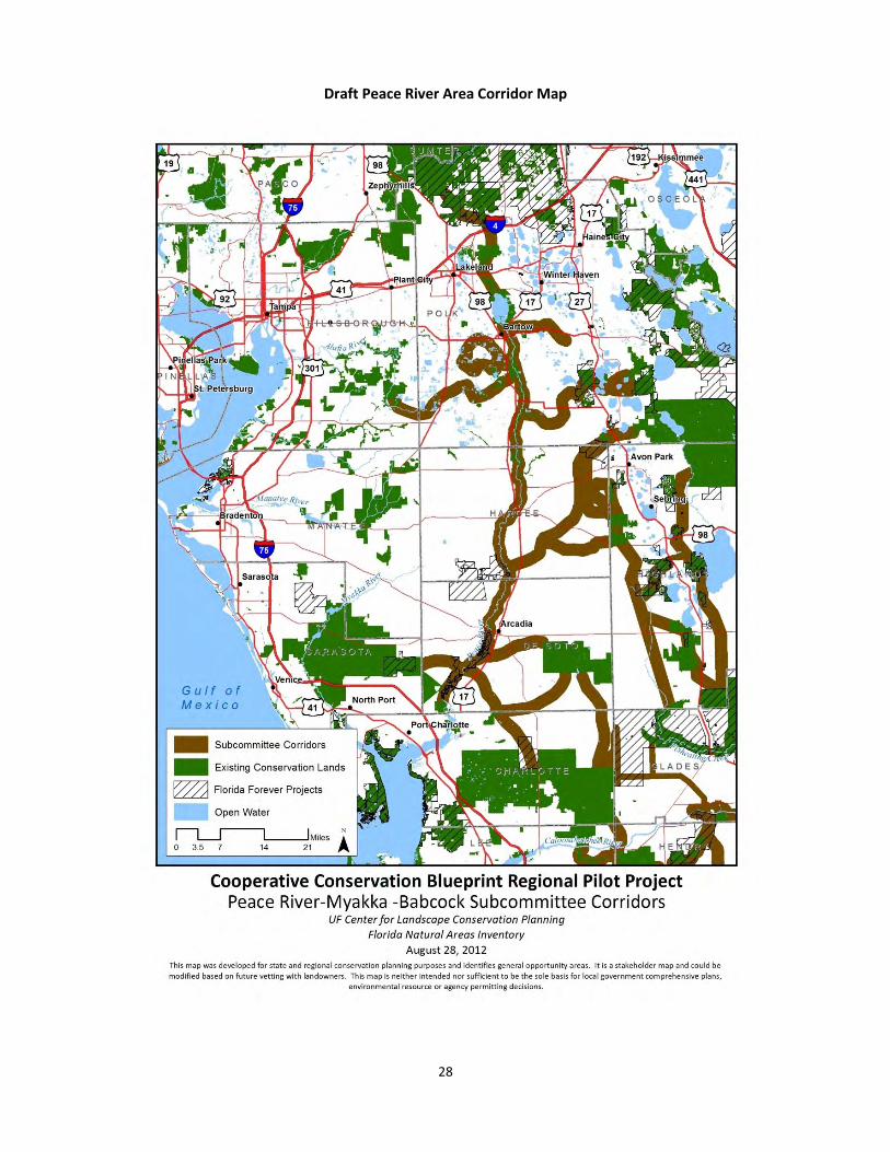
2) The “Peace River Subcommittee” identified corridors ranging from Babcock Ranch in Charlotte
County, west to the Myakka River conservation complex, north along the Peace River to the Green Swamp and along various tributaries to the west and east of the Peace River including interconnection to corridors along the Ridge to the east.
3) The “Caloosahatchee Subcommittee” focused on the Florida Panther National Wildlife Refuge northward to the Fisheating Creek Wildlife Management Area and to the Babcock Ranch Preserve (Collier, Hendry, Lee, and Glades Counties).
This process included a total of seven subcommittee meetings held between August and December 2011 with many additional individual meetings and phone conversations between Blueprint staff members and
2 Babcock Ranch Steering Committee. Babcock Ranch Steering Committee Final Report, January 2011. Pg. 2.
http://www.charlottefl.com/outreach/pzdocs/babcock/BabcockSteeringCommitteeFinal2011.pdf
13
representatives of natural resource management agencies, non-governmental organizations (NGOs), subcommittee members and landowners throughout the region. In general the Corridor Subcommittees recognized that:
1) The key for creating or maintaining corridors is to circumvent barriers to wildlife movement while developing incentives-based approaches to protect best available routes for functional connectivity.
2) The Pilot region is a high priority landscape for several agencies and focus should remain on potential
connections between Florida Forever land acquisition projects, WRP easements, the Everglades Headwaters National Wildlife Refuge, the new Fisheating Creek Wildlife Refuge and expansion of the Florida Panther National Wildlife Refuge.
3) Involvement of landowners is crucial to successful corridor protection.
4) Incentives are essential to landowner participation and will be most effective when identified and applied on a case by case basis.
5) Subcommittee members had valuable knowledge about the opportunities and obstacles to
connectivity in the region. The Southwest Florida Blueprint Pilot Project Area: 2011 Year-end Summary Report provides comprehensive detail of the results of the extensive effort put forth to identify challenges and opportunities for connectivity in this large and ecologically significant region. In addition to a vast array of recommendations for corridor implementation and policy adjustments, “arrow maps” were created to define areas considered most advantageous for corridor protection and practicable for implementation (Appendix I). In addition to recruiting the AG, Blueprint staff met with representatives of various regulatory agencies, water utilities and resource managers to encourage their participation in the Blueprint conservation priorities and incentive development. In collaboration with the South Florida Water Management District (SFWMD), staff members convened a Lake Okeechobee Interagency meeting highlighting activities in the Blueprint Pilot region. That meeting formed the foundation for further coordination between Blueprint staff, agencies and NGOs. In the fall of 2012 staff organized a meeting of key land and wildlife management experts representing several state and federal land management and planning entities. The daylong meeting provided for an open discussion of agency projects, Blueprint Pilot conservation tools and ultimately, within the context of agency conservation data needs, how continuing collaboration can support agency policy decision making and serve implementation goals of the Blueprint project. Most of the entities involved in this meeting currently manage incentives-based programs for conservation of agricultural lands. Relationships developed throughout the Blueprint project underscore the potential for a coordinated, effective and efficient interagency programmatic approach to successful landscape scale conservation.
14
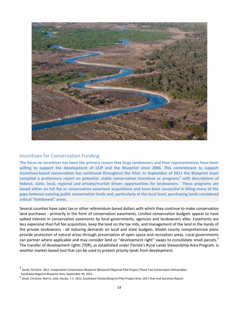
Incentives for Conservation Funding The focus on incentives has been the primary reason that large landowners and their representatives have been willing to support the development of CLIP and the Blueprint since 2006. This commitment to support incentives-based conservation has continued throughout the Pilot. In September of 2011 the Blueprint team compiled a preliminary report on potential, viable conservation incentives or programs3 with descriptions of federal, state, local, regional and private/market driven opportunities for landowners. These programs are based either on full fee or conservation easement acquisitions and have been successful in filling many of the gaps between existing public conservation lands and, particularly at the local level, purchasing lands considered critical “bottleneck” areas.
Several counties have sales tax or other referendum-based dollars with which they continue to make conservation land purchases - primarily in the form of conservation easements. Limited conservation budgets appear to have spiked interest in conservation easements by local governments, agencies and landowners alike. Easements are less expensive than full fee acquisition, keep the land on the tax rolls, and management of the land in the hands of the private landowners - all reducing demands on local and state budgets. Model county comprehensive plans provide protection of natural areas through preservation of open space and recreation areas. Local governments can partner where applicable and may consider land or “development right” swaps to consolidate small parcels.4 The transfer of development rights (TDR), as established under Florida’s Rural Lands Stewardship Area Program, is another market-based tool that can be used to protect priority lands from development.
3 Small, Christine. 2011. Cooperative Conservation Blueprint (Blueprint) Regional Pilot Project; Phase Two Continuation Deliverables
Southwest Regional Blueprint Area. September 30, 2011. 4 Small, Christine, Morris, Julie, Hoctor, T.S. 2012. Southwest Florida Blueprint Pilot Project Area: 2011 Year-end Summary Report.
15
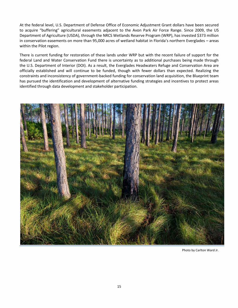
At the federal level, U.S. Department of Defense Office of Economic Adjustment Grant dollars have been secured to acquire “buffering” agricultural easements adjacent to the Avon Park Air Force Range. Since 2009, the US Department of Agriculture (USDA), through the NRCS Wetlands Reserve Program (WRP), has invested $373 million in conservation easements on more than 95,000 acres of wetland habitat in Florida’s northern Everglades – areas within the Pilot region.
There is current funding for restoration of these lands under WRP but with the recent failure of support for the federal Land and Water Conservation Fund there is uncertainty as to additional purchases being made through the U.S. Department of Interior (DOI). As a result, the Everglades Headwaters Refuge and Conservation Area are officially established and will continue to be funded, though with fewer dollars than expected. Realizing the constraints and inconsistency of government-backed funding for conservation land acquisition, the Blueprint team has pursued the identification and development of alternative funding strategies and incentives to protect areas identified through data development and stakeholder participation.
Photo by Carlton Ward Jr.
16
Moving Forward The pursuit of excellent natural resource data, incentives development and stakeholder outreach has been the hallmark of the Blueprint since its inception. Discussions with many landowners in the Pilot region supported the primary challenges to successful collaboration with landowners indicated early on by the AG. Agricultural producers must be able to maintain financial viability and be provided consistency in regulatory resource protection program requirements. These issues will determine ultimate involvement of the agricultural community in habitat protection and therefore the success of a corridor implementation program. In order to address these issues of uncertainty, the Blueprint recommends the following strategies to deal with planning, policy, and funding for protection of identified conservation priorities.
Continue to Identify and Promote Connectivity Wildlife corridors are essential for the long term viability of many focal and fragmentation-sensitive species. These areas that functionally connect larger conservation areas within the Pilot region, and to other adjacent regions, must be protected. Identification of these areas is the first step. Development of similar Regional CLIP datasets integrating or comparing state, regional, and local conservation priority data should be a priority for enhancing collaboration and expanding the scope of incentives-based conservation strategies. As the state plans for climate change and rising sea levels, much more attention to our southern-northern connections is warranted, and the southwest corridors provide options for functionally connecting south and north Florida. Additional efforts with conservation partners and stakeholders are needed to support enhanced identification and implementation of regional ecological networks throughout the state.
Continue to Focus on Interagency Coordination and Buy-In Interagency coordination is fundamental to the implementation of corridors through an organized and focused effort to maintain the integrity of large conservation landscapes for sustainable wildlife habitat and biodiversity. A major indicator of success for the overall Blueprint project will be action by federal, state, regional and local governments to confirm support of recommended corridors and incentives by incorporating protection for these critical areas in their policies and procedures. Through the Pilot efforts the Blueprint team has set the stage for multi-agency “buy-in” that can lead to the ultimate goal of implementation of priority conservation goals. Substantial support for the Blueprint process has been developed within agency and NGO staff members. Because of the subcommittee work, interagency coordination at many levels, as well as interaction with members of private industry and conservation groups, the Blueprint project values are regularly referred to in planning presentations by various agencies.5 Work across agency boundaries with consistent data on conservation priorities as a strategy to protect identified wildlife corridors and priority landscapes must be continued. Formal recognition and adoption of the southwest corridor maps as a guide for regional application of conservation incentive programs by the State of Florida could significantly aid conservation. Further, there can be a collaborative interagency “top priority” agreement that directs funding and management partners to pursue an expedited implementation of these corridors. At a minimum, federal, state, regional and local entities could budget preferential funding for projects in, adjacent to or nearby Blueprint Pilot identified conservation priorities. Focusing on incentives-based conservation approaches, these entities can work together to direct future development away from and minimize environmental impacts to conservation priority areas. Furthermore, as state and regional land management agencies are under pressure to surplus lands, providing current data and strategic analyses to agency staff members can support decision making processes.
5 Romig, Robert. Heartland 2060 FDOT Future Corridors Presentation. August 8, 2012. Sebring, FL.
2013 "Lunch with 1000 Friends of Florida" Webinar -- 2013 Legislative Preview -- noon until 1:30, Wednesday, January 9. This is part of the Dr. John M. DeGrove Community Steward Webinar Series.

17
The Blueprint team has been working with the NRCS staff to create a method by which WRP and/or other federal programs might assign bonus rankings to priority corridor areas. This is an excellent example of how corridor prioritization can be incorporated into existing programs in a manner that advances the resource conservation goals of both the Blueprint and partner agencies. Other potential programmatic accommodations might include federal and state bonus and combined banking credits, increased grant competitiveness, higher cost-share rates and changes to match requirements, adjusted gross income requirement waivers and/or additional landowner tax incentives. Greater detail on specific recommendations for working with agencies is attached as Appendix III, Conservation Cooperative Blueprint Strategic Opportunities with Partners.
Continue to Pursue Landowner Involvement Staff and stakeholders are aware that agricultural producers are under financial constraints and must maintain economic viability in order to sustain production and protect conservation values inherent to their lands. While landowners greatly value their agricultural tradition and would like to ensure that their heritage continues into future generations, without adequate currency (either cash or other calculable benefits), the members of the agricultural community may decide to subdivide, develop, or otherwise sacrifice the congruity and conservation value of these large parcels. In order to avoid this situation, creation of additional funding for protecting Blueprint priority areas in perpetuity is the key to successful conservation. Building on the foundation established in the Pilot, provisions must be made to continue efforts to engage landowners and agencies in the alignment of identified priority areas with existing and new incentives. Policy and programmatic accommodation for protection of these vital ecological connections will determine the level of landowner participation and support for current and future corridor implementation. When agencies and other land management partners confirm identified conservation priorities in existing and potential future incentives-based conservation programs, landowners can recognize the value of having defined corridors on their property and consider conservation activities an asset rather than a liability. Further detailed and effective policy-

18
making processes for habitat protection can bolster the efficacy of the Blueprint process making it more attractive to landowner, agency and conservation organization participation.
Expand Funding Opportunities Additional dedicated financial resources are needed to protect natural resources in Florida. Because government program funding depends on many variables, the Blueprint team has focused on the development of new market-based funding incentives for acquisition of land and development rights. Several market-based tools already in use by various levels of government can be expanded for application of corridor protection. The Blueprint team recommends that state, regional, and local governments pursue regional TDR programs that will incentivize redevelopment in existing urban areas while protecting high priority rural landscapes from conversion to intensive development. Two additional methods of funding for preservation and restoration projects are growing outside of traditional public program methodologies. Mitigation/conservation banking and PES projects have great potential for expanded conservation protection based on market and agency budget conditions.
Mitigation Through collaboration with the WMDs and the Florida Department of Environmental Protection (FDEP), more than 30 wetland mitigation banks have been approved by the State for various projects. For example, The Florida Department of Transportation (FDOT) established its first habitat conservation bank on a 1,700 acre ranch in Highlands County. The Platt Branch Mitigation Park provides habitat for seventeen protected species, several rare plant communities and is part of the larger 18,000 acre Fisheating Creek ecosystem.6 FWC manages the property and FDOT has invested almost $5 million in the acquisition and endowment for management. This project is indicative of Florida’s “off-site regional, multi-use approach” that could provide funding for protection of regional wildlife corridors and other conservation priority areas throughout the State.
Although the FDOT “Environmental Stewardship” policy is to avoid impacts to “must save” habitat, the FDOT Future Corridors Action Plan maps reveal many areas of potential conflict between corridors for wildlife and transportation.7 The action plan states specifically that a primary goal and official policy for FDOT is to “Offset unavoidable impacts to natural resources through mitigation.”8 Within the rural interior between Collier and Polk Counties there is great potential for mitigation dollars to be dedicated to wildlife corridor protection.
6 http://www.environment.fhwa.dot.gov/ecosystems/eei/fl.asp
7 2009. Florida’s Future Corridors Action Plan. Florida Department of Transportation. Pg. 12, 16.
8 Ibid. Pg. 9.
19
In addition, recent discussions with state regulatory agencies have revealed a willingness to investigate the possibility of mitigation rule expansion and revision to support payment of services for ecosystem protection and restoration. FDEP staff members responsible for mitigation rules have suggested there might be an opportunity to expand permitting requirements to encourage protection of priority conservation areas and top executives at SFWMD have stated support for exploring mitigation as an alternative funding source for habitat protection. Pursuit of potential agency flexibility to create more effective programs is recommended. With the new state legislation, HB 1389, providing “safe harbor” for landowners willing to be involved in dispersed water management projects, there is a legal framework that provides for an initial baseline for wetland assessments to be provided by FDEP and WMDs. This baseline establishes a barometer for calculation of ecological improvement based on restoration practices in a particular area. The documented improvement is called “lift” and is the value for which mitigation dollars are paid. Taking that potential to the next level, Blueprint staff members encourage policies that would allow agricultural producers to create private mitigation banks on an expanded watershed scale. Individually or through cooperative ventures, the agricultural community could, with multi-agency cooperation, provide new and expansive opportunities for habitat protection statewide. At the federal level, beginning in April of 2008, the US Army Corps of Engineers and the US Environmental Protection Agency published joint guidance that recognizes the potential value of accounting for and crediting the full range of ecosystem services involved in mitigation processes. Application of agency mitigation credits for various ecosystem services could substantially support the success of the water quality and wildlife best management practices programs under development in Florida. With agency support, the proper “valuation” of these services could be a game-changer in the ability to compensate landowners for ecosystem protection and enhancements.9
Payments for Ecosystem Services To date, ecosystem services and market programs have been driven by regulatory requirements and are primarily supported with public funding. The need to meet water quality standards and increase cost efficiency has resulted in creative programs that engage broad-based stakeholder groups. Depending on the collaboration with agricultural producers to improve environmental conditions and reduce the cost of infrastructure, successful programs such as those for New York City, Willamette, Oregon, and Ohio’s Miami River Watershed have been breaking ground in this relatively new field of ecosystem preservation and restoration. Here in Florida, the SFWMD in cooperation with the Florida Department of Environmental Protection, the Florida Department of Agriculture and Consumer Services and the USDA NRCS instituted the Northern Everglades Payment for Ecosystem Services Program (NE-PES) in 2011 as part of a larger dispersed water management program. This water storage program is a successful collaboration between regional water managers and the agricultural community. Driven by water quality and restoration mandates as well as the need for cost-effective strategies, this project pays ranchers for water storage on their land and is considered by ecosystem services experts to be a state-of-the-art agency/industry collaboration for effective resource management. Future funding is in place for the expansion of NE-PES, but with an ultimate goal of storing approximately a million acre-feet of water in the Northern Everglades, new or expanded PES programs must include a broader base of funding and less reliance on government dollars. To that end, another agricultural water storage project is in development that will involve citrus growers in the Indian River Lagoon watershed. Stormwater releases from large canals in the area are damaging the Lagoon and offshore marine resources by creating imbalances of salinity
9 Ruhl, J.B. Agriculture and Ecosystem Services: Strategies for State and Local Governments. NYU Environmental Law Journal, Vol. 17, No. 1, 2008. Pg. 426.
20
and nutrient levels. “Water farming” funded by utilities in the Lower St. Johns River can provide storage for huge volumes of stormwater currently being released to coastal estuaries. Such beneficial scenarios, this one featuring collaboration between the SFWMD and St. Johns River Water Management District, private landowners and industry, is being pursued for water and land resource protection. Public recognition and potential investor awareness of the value of agricultural lands for resource protection and restoration are key to any successful PES program. Agricultural operations have, in recent years, been recognized by economists and environmentalists as suppliers of multiple public benefits by “housing the natural capital capable of providing a stream of diverse . . . services, including . . . increased biodiversity, carbon sequestration, pollination, groundwater recharge, and improvement of water quality”.10 The FWC, along with many other public and private agencies, recognizes this “multi-functionality”11 and recommends that in order to maintain habitat for common and endangered species, ranchers and farmers must be supported in their efforts to continue providing these services to the general public.
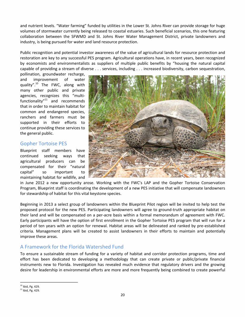
Gopher Tortoise PES Blueprint staff members have continued seeking ways that agricultural producers can be compensated for their “natural capital” so important to maintaining habitat for wildlife, and in June 2012 a new opportunity arose. Working with the FWC’s LAP and the Gopher Tortoise Conservation Program, Blueprint staff is coordinating the development of a new PES initiative that will compensate landowners for stewardship of habitat for this vital keystone species. Beginning in 2013 a select group of landowners within the Blueprint Pilot region will be invited to help test the proposed protocol for the new PES. Participating landowners will agree to ground-truth appropriate habitat on their land and will be compensated on a per-acre basis within a formal memorandum of agreement with FWC. Early participants will have the option of first enrollment in the Gopher Tortoise PES program that will run for a period of ten years with an option for renewal. Habitat areas will be delineated and ranked by pre-established criteria. Management plans will be created to assist landowners in their efforts to maintain and potentially improve these areas.
A Framework for the Florida Watershed Fund To ensure a sustainable stream of funding for a variety of habitat and corridor protection programs, time and effort has been dedicated to developing a methodology that can create private or public/private financial instruments new to Florida. Investigation has revealed much evidence that regulatory drivers and the growing desire for leadership in environmental efforts are more and more frequently being combined to create powerful
10 Ibid, Pg. 429. 11 Ibid, Pg. 429.
21
forces for funding conservation initiatives in many areas across the US and abroad.12 Many of these efforts have been designed to address watershed scale pollution and degradation issues. Fortunately, there are tools in law and in the marketplace that have and can be useful to implement a statewide funding program for conservation at this scale in Florida. Based on research into these mechanisms and public/private PES programs, Blueprint staff met with water and wastewater utilities representatives in the northern reaches of the Pilot area to discuss potential projects that might satisfy industry and landowner needs. These industry leaders could envision, and did support in concept, the many environmental co-benefits that could be realized through collaboration with landowners for wetlands restoration and/or shallow surface water storage. Considering the cost of new construction for regulatory compliance, avoiding these expenses through credit trading collaborations is an attractive proposition. While willing to continue the dialogue, utility representatives require specifics regarding potential legal agreements, types and location of projects, and benefits they might expect in such an arrangement. Based on discussions with regulatory agency staff members, experienced credit trading leaders and Florida water law experts, extensive research has been done to create a proposal outlining a framework for a statewide water quality trading program in Florida. This proposal is currently under review by regulatory and private water and utility industry experts. There is interest among agency, agriculture and water industry representatives in the development of an expanded water quality and/or supply trading program.
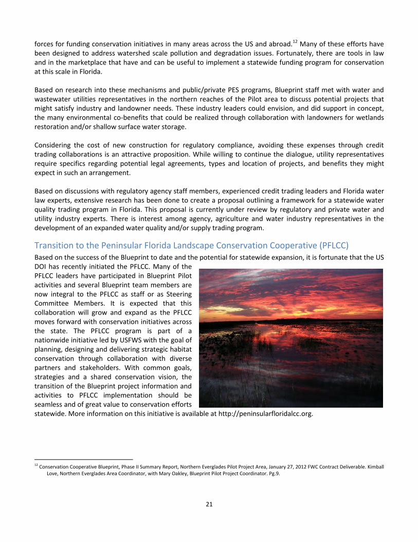
Transition to the Peninsular Florida Landscape Conservation Cooperative (PFLCC) Based on the success of the Blueprint to date and the potential for statewide expansion, it is fortunate that the US DOI has recently initiated the PFLCC. Many of the PFLCC leaders have participated in Blueprint Pilot activities and several Blueprint team members are now integral to the PFLCC as staff or as Steering Committee Members. It is expected that this collaboration will grow and expand as the PFLCC moves forward with conservation initiatives across the state. The PFLCC program is part of a nationwide initiative led by USFWS with the goal of planning, designing and delivering strategic habitat conservation through collaboration with diverse partners and stakeholders. With common goals, strategies and a shared conservation vision, the transition of the Blueprint project information and activities to PFLCC implementation should be seamless and of great value to conservation efforts statewide. More information on this initiative is available at http://peninsularfloridalcc.org.
12 Conservation Cooperative Blueprint, Phase II Summary Report, Northern Everglades Pilot Project Area, January 27, 2012 FWC Contract Deliverable. Kimball
Love, Northern Everglades Area Coordinator, with Mary Oakley, Blueprint Pilot Project Coordinator. Pg.9.
22
Strategic Approach
Strategic Partnering Opportunities A primary goal of the Blueprint process has been to “develop a common set or ’common currency’ of GIS-based conservation priorities used by all relevant agencies and partners as a foundational guide for incentives-based conservation planning and programs.”13 This common currency can provide a foundation for comprehensive and effective regional and statewide implementation of conservation priorities. The following is a list of current and potential partnering and project opportunities (more detailed descriptions are included as Appendix III):
U. S. Department of Agriculture Natural Resources Conservation Service – Wetlands Reserve Program
o Refine Pilot Corridors with continued landowner outreach.
o Integrate Blueprint priority area value into programmatic ranking.
U.S. Fish and Wildlife Service Refuge Proposals o Promote consistency of Regional CLIP
and Pilot corridors with refuge planning. o Collaborative strategic acquisition goals. o Prioritize potential parcels for
acquisition. o Optimize strategic landscape
connectivity.
Photo by Carlton Ward Jr. U.S. Fish and Wildlife Service Peninsular Florida Landscape Conservation Cooperative
o Integrate Regional CLIP and Pilot corridors into PFLCC for research and planning. o Develop interagency consensus for conservation priorities. o Advocate for protecting priorities through incentives-based program support. o Complete the latest version of CLIP - (CLIP3.0).
South Florida Water Management District Dispersed Water Storage Program- Northern Everglades Payment for Ecosystem Services
o Investigate opportunity to identify strategic candidate parcels for dispersed water storage areas. o Integrate Blueprint priority areas and other conservation priority co-benefits value into
programmatic ranking.
Florida Department of Environmental Protection Office of Greenways and Trails (OGT) Florida Greenways
o Identify overlap of Blueprint/Florida Greenways and Trails System (FGTS) Plan priorities. o Promote education and outreach in support of “functionally connected landscapes”.14
13 Hoctor, T. S., Conservation Cooperative Blueprint Strategic Opportunities with Partners. 2012 (Attached as Appendix III). 14
Ibid, pg. 8

23
Florida Department of Agriculture and Consumer Services o Pursue funding for BMP implementation. o Continue creation and implementation of Wildlife BMPs.
Florida Department of Transportation Future (Transportation) Corridors Program (FCP) o Ensure FDOT access to current Blueprint data and priority areas. o Create overlays comparing transportation and Blueprint priority areas. o Ensure FDOT uses Blueprint information to avoid or minimize impacts to priority areas. o Determine scale of mitigation required to compensate for FCP impacts to priority areas. o Encourage FDOT to mitigate impacts by funding incentive-based conservation strategies. o Encourage application of Blueprint process to additional FCP areas throughout the state.
Conservation Trust for Florida (CTF) o Expand CTF Easement Workshop Program to south-central/southwest Florida.
Explore additional conservation incentives discussion and partner participation in workshop
format.
Multi-agency Listed/Focal Species Habitat Protection/Management/Payments for Ecosystem Services
o Enhance coordination to address multi-agency/Blueprint conservation priority overlap including on species such as Florida panther, Florida grasshopper sparrow, gopher tortoise, and Florida black bear.
o Expand proactive and strategic voluntary protection program funding alternatives. o Develop a Florida Panther outreach program including possible PES program.
Mitigation Banking – US Army Corps of Engineers (USACE), Florida Department of Environmental Protection. Water Management Districts
o Encourage multi-agency coordination of policies and procedures. o Modify bank location selection criteria to maximize multiple conservation benefits. o Explore feasibility of credit stacking for wetland/priority habitat conservation. o Ensure compatibility of mitigation banking and PES programs.
Identification and Protection of Strategic Areas o Continue to identify strategic areas based on threat of development. o Focus on corridor “bottlenecks” including small parcels or narrow areas critical to connectivity. o Identify potential near term strategic protection opportunities based on existing conservation
programs and landowner interest. o Ensure Blueprint Pilot conservation priorities inform the conservation vision included in regional
planning council initiatives.
24
Blueprint Pilot Priority Strategic Opportunity Areas Many of these strategic areas are within the boundaries of on-going agency supported conservation projects. Continuing programmatic coordination and pursuit of incentive based funding can support these priorities:
Proposed Everglades Headwaters Refuge site located across US 27 in southeastern Polk County Corridor crossings across the Caloosahatchee River and especially the Caloosahatchee Ecoscape Florida
Forever Project Peace River-Green Swamp corridor connector and Interstate 4 crossing in northern Polk County US 27 corridor crossing between Smoak Ranch and Archbold Biological Station in southern Highlands
County Ecological connectivity between Kissimmee Prairie State Preserve and Three Lakes Wildlife Management
Area and the conservation lands along the upper St. Johns River in Osceola and Okeechobee counties Ranchlands within corridors between Babcock Ranch, Bright Hour conservation easement, and the
Fisheating Creek Wetland Reserve Program easements in Charlotte, Desoto, and Highlands counties that also have significant potential for Gopher Tortoise PES
Areas of parcel fragmentation in corridors between Babcock Ranch-Peace River-Myakka conservation lands primarily in Desoto County.
Various Florida Forever projects adjacent to Okaloacoochee Slough State Forest in Hendry and Collier counties
Lands between Fisheating Creek Wetland Reserve Program easements and Highlands Hammock State Park in Highlands County
25
Photo by Carlton Ward Jr.
The majority of these projects directly or indirectly addresses watershed restoration and can stand as candidate projects for consideration for support under The Florida Watershed Fund. Furthermore, “riparian network analysis” and identification of priority locations for dispersed water storage that include natural areas, as well as abandoned or active agricultural facilities, could be pursued to meet state water management goals. Additional research in these areas has the potential to support a menu of conservation goals that are inherent to the Blueprint and conservation missions of many agencies.15
The common currency of the Blueprint data underpins conservation goals, supports the work of the FWC State Wildlife Action Plan and fulfills several goals of the USFWS and PFLCC. Ensuring that the PFLCC adopts the work done by the Blueprint Pilot would further implementation efforts. The FWC should work with the USFWS and other PFLCC partners to incorporate the identified conservation priorities into that cooperative effort. The UF CLCP is continuing to expand its work in the Blueprint Pilot region through development of CLIP version 3.0 under the auspices of the PFLCC. The Gopher Tortoise PES program will be launched in 2013 in its test phase. This collaboration between landowners and FWC will move toward implementation over the next year. It is anticipated that The Watershed Fund proposal will be shepherded into its feasibility phase in the beginning of 2013 and discussions will continue as to how collaboration and outreach instituted in the Pilot can be carried on. In addition, members of the Blueprint team will work with the Central Florida Regional Planning Council on the Heartland 2060 regional visioning project to ensure Blueprint Pilot conservation priorities inform the conservation vision in their planning region.
15
Ibid, pg. 26 of this report
26
Conclusions Historically throughout Florida there has been a monumental effort by local, state and federal governments to acquire conservation lands. This is particularly true in the Pilot study area. In many instances these public and private lands are contiguous, creating great swaths of natural and working lands. There lies in the “Heartland” of Florida a tremendous opportunity for routing corridors through a quilt of public and private conservation lands, conservation and mitigation banks across a landscape mosaic of natural and rural lands. Public acquisition of property by itself will not accomplish the overall goal of conserving wildlife and rural landscapes in this region. Protection of the integrity of the recommended corridors will require working cooperatively with conservation agencies and organizations, landowners and businesses through a combination of purchases, easements, incentives, restoration and enhancements, new voluntary non-regulatory incentives, market-based incentives, as well as long-term management funding. Because private lands are so necessary to the health and well-being of Florida’s natural resources, it is necessary to provide landowners with the benefits and assurances necessary to their successful operations. We recommend working with local, regional, state and federal agencies to establish mixed use and other entitlements such as trades of development and density rights in other areas in exchange for setting aside land in Blueprint priority corridors. In addition, incentives should address various levels of ownership (individual, corporate, etc.), various parcel sizes and that maps and incentives should be introduced to potential partners simultaneously.
The lessons learned from the agricultural community are simple in that sustainable business and regulatory certainty are the mainstays of a vibrant agricultural economy. With the majority of critical habitat on private lands, all conservation efforts must focus on protecting these lands from fragmentation in perpetuity. There must be a well-designed and funded roadmap that leads us to that goal. The efforts of the Blueprint in southwest Florida have provided the base infrastructure to complete that roadmap. Considering the potential impacts from extraordinary population growth and sea level rise, with the resulting impacts to the built environment and limited access to freshwater in densely populated coastal areas, now is the time to develop strategies for adaption to and mitigation for these eventualities. Given the potential of future community and transportation infrastructure development across the State of Florida, a sustained and comprehensive Blueprint style effort to create regional assessments and visioning for ecosystem protection should be instituted statewide. Many of the recommendations created within the Blueprint Pilot involve changes that would need to take place at various levels of governance. Additional programmatic funding, agency policy changes and tax relief are all issues that require examination and extensive effort to implement. However, through the continuing research for corridor identification and pursuit of effective and efficient methods of funding various incentives, there is great potential for conservation success that balances the needs of landowners, wildlife, ecosystem services, and the public at large.
27
APPENDIX I - Southwest Florida Blueprint Study Area Maps
28
Draft Peace River Area Corridor Map
29
Draft Fisheating Creek Area Corridor Map
30
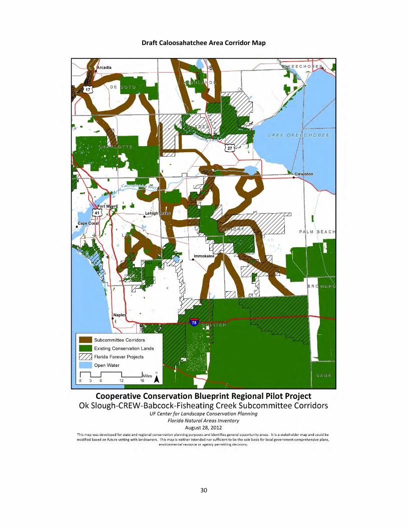
Draft Caloosahatchee Area Corridor Map
31
APPENDIX II - Landowners Assistance Group
Chuck Aller, Former Director of the Office of Water Policy – Florida Department of Agriculture and Consumer Services.
Chuck Littlejohn, Owner, Littlejohn, Mann & Associates – Represents the Florida Land Council comprised of some of the largest parcel landowners in the state.
Mike Minton, President, Dean Mead Law Firm, former Vice Chair, South Florida Water Management District, Chair-Elect of the Board of Trustees for the University of Florida Law Center Association, Inc., Vice Chair of the Harbor Branch Oceanographic Institute Foundation, Inc., member of the Orlando Chamber of Commerce and Board of Directors of the Central Florida Partnership. Mike Adams, President, Adams Ranch – Responsible for operating approximately 65,000 acres of ranchland and citrus groves in Okeechobee, St. Lucie, and Osceola Counties. Mike serves on many boards including the St. Lucie County Soil and Water Conservation District, University of Florida Treasure Coast Research Foundation, St. Lucie County Farm Bureau, the Florida Braford Breeders, and the Treasure Coast Resource Conservation & Development Council, and the Foundation Board of Indian River State College.
Dr. Hillary Swain, Director, Archbold Expeditions – Responsible for directing activities at Archbold Biological Station and the MacArthur Agro-ecology Research Center (MAERC). Dr. Swain is a Fellow of the American Association for the Advancement of Science and is past President of the Organization of Biological Field Stations. Among other appointments she currently serves as: Board member for the National Ecological Observation Network, Inc. (NEON); Board member for NatureServe; Chairperson of the Babcock Ranch, Inc. Board of Directors; and member of the Natural Resources Advisory Commission (NRAC) for Highlands County, Florida.
Mitch Hutchcraft, VP of Real Estate/Consolidated Citrus, King Ranch – Responsible for all issues related to real estate for King Ranch. Mitch recently succeeded in securing approval of new AgTEC center in western Martin County that will house new industry and agricultural research. Rehydration and other environmental improvements are planned for the property. Ron Edwards, CEO, Evans Properties – Evans Properties owns and operates over 30,000 acres in eight counties for citrus and cattle ranching. Ron’s leadership has been recognized with many awards and has distinguished the operations as innovative, conservation oriented, and technologically progressive.
Cary Lightsey, Owner, Lightsey Ranch – Cary operates 36,000 acres of land in the Kissimmee Basin where he raises cattle, produces citrus and sod, provides hunting services and is known as a conservationist as well as a top flight agricultural producer having just this last year been recognized as Florida’s Sunbelt Farmer of the Year. Cary is participating in the South Florida Water Management District (District) Northern Everglades Payment for Environment Services (NE-PES) Program.
32
APPENDIX III - Cooperative Conservation Blueprint Strategic Opportunities with Partners
By: Tom Hoctor December 9, 2012 The following is a discussion of opportunities to work with potential partners on programs and initiatives that could be relevant to efforts to protect Regional CLIP and Subcommittee Corridor (i.e., the Regional Blueprint) priorities within the Cooperative Conservation Blueprint Pilot Project (Pilot) study area. Discussions with representatives of these programs and initiatives could also lead to consideration of a broader application of Regional CLIP and Blueprint methods into other parts of Florida beyond the current Pilot study area. In the August progress report16, we included two sections, one discussing partner program opportunities and the other covering potentially relevant Geographic Information Systems (GIS) analyses for identifying areas of significance for various incentives-based conservation programs within Blueprint priority areas. Some of these GIS analyses have been made unnecessary based on our discussions with various partners including at the October 2012 partners roundtable, though others may still be relevant to further define potential overlap in priorities across agencies or with other partners. Therefore, these discussions have been merged below when relevant to a particular agency or program. Another important element of strategic opportunities is geography. Future work on Blueprint priorities will likely need to include identification of specific priority or focal areas that either need immediate attention due to threats such as conversion to intensive land uses, or provide specific protection opportunities. We discuss some of these areas in the second section below. Overall, the primary goal is to develop a common set or “common currency” of GIS-based conservation priorities used by all relevant agencies and partners as a foundational guide for incentives-based conservation planning and programs. The Blueprint Pilot project effort builds on the success in this regard by the statewide CLIP, by starting with CLIP data and bringing additional regional/local detail that is used to identify both science and stakeholder consensus conservation priorities. This combination of CLIP data, regional conservation priority data, and conservation priorities identified by stakeholders can enhance and facilitate the conservation work of all federal, state, and regional agencies and other partners in the Pilot region and throughout the state if similar processes are pursued. Discussion of Relevant Partner Opportunities 1) US Department of Agriculture (USDA) Natural Resources Conservation Service (NRCS) Wetlands Reserve Program (WRP) Blueprint staff members have met with NRCS staff several times including at the October 2012 Science Roundtable. In these meetings the WRP has been the primary topic, though there are other NRCS programs that might be relevant to protection of Blueprint priority areas in the future. Though there are some limitations in the applicability of WRP to protection of Blueprint priority areas, recent WRP easements have protected critical portions of Blueprint priorities including parts of the “Western Corridor” in the Fisheating Creek basin, which connects conservation lands along Fisheating Creek to Avon Park Air Force Range in Highlands and Polk Counties.
16
Small, Christine, Morris, Julie, Hoctor, T.S. 2012. Southwest Florida Blueprint Pilot Project Area: 2011 Year-end Summary Report.
33
WRP easements have the potential to protect additional significant lands that are Blueprint priorities including the potential completion of identified priority corridors. However, there are several potential primary limitations to WRP regarding Blueprint priorities. WRP targets degraded and even highly degraded wetlands that can be restored through changes in land use and land management practices and rehydration of affected wetlands. Candidate WRP lands include former or highly degraded wetlands that have been drained, converted to improved pasture, or converted to more intensive agriculture. In addition, NRCS handles WRP as primarily a reactive program; NRCS evaluates applications that are brought to them by landowners but does not strategically identify conservation priorities that are a good fit for the program and approach landowners about such properties. Additionally, WRP cannot be used to protect even small areas that are connected to degraded wetlands and would be advantageous for connecting to other protected areas, but do not include degraded wetlands. NRCS does include GIS data, with help from the Florida Fish and Wildlife Conservation Commission (FWC) Landowners’ Assistance Program (LAP), which identifies strategic conservation priorities such as CLIP data and Everglades Headwaters National Wildlife Refuge priorities. However, as discussed at the Science Roundtable in October 2012, NRCS prefers that any GIS data used for evaluation purposes should represent specific geographic priorities and “bona fide” as a reliable source of conservation priority areas. In this regard, some concern was expressed about the current status of the Blueprint Subcommittee Corridor data and whether it could be used in the WRP application evaluation process. These considerations lead to the following recommendations for maximizing the coordination and potential benefit of the WRP to protection of Blueprint priorities:
1. Work to “finalize” the Subcommittee Corridors by providing more specific corridor boundaries through: a) overlap with Regional CLIP Priority1 (P1) areas and/or corridors within the Florida Ecological Greenways Network (FEGN); b) overlap with corridors within the Babcock Moderate Connectivity Scenario; c) more specific corridor data where available such as for various corridors within the Peace River basin provided by Julie Morris; and d) additional corridor vetting with strategic landowners when feasible. In addition, if these corridor data are completed, we should discuss the feasibility/desirability of giving these areas the highest priority in the WRP evaluation scoring process, with Regional CLIP P1 priorities still being used but receiving fewer points than areas included in the Subcommittee Corridors.
2. Work with NRCS and FWC to add a question to the WRP evaluation process/form that gives significant additional scoring points to areas within, adjacent, or near Blueprint priority areas, including at least Regional CLIP P1 priorities to start but also working to get the Subcommittee Corridors included. More specifically, add the following to the NRCS WRP Ranking Worksheet:
Factor 3 – Location Proposed criterion: Proposed easement at least partially overlaps a "Subcommittee Corridor" identified through the Blueprint Pilot Project. Proposed points: 20-30, possibly depending on how much overlap. Rationale: The Location Factor appears to be where NRCS gives a proposal credit for being next to or within areas identified as priorities through a variety of other conservation programs including an existing criterion that mentions the Blueprint, as well as wildlife corridors, so it seems a good fit with the stakeholder-driven Subcommittee Corridors from the Blueprint Pilot. We could also consider factoring in Regional CLIP P1 here (and/or statewide CLIP priorities), with fewer points awarded than for the Subcommittee Corridors. Factor 4 – Wildlife Species
34
Proposed criterion: Proposed easement is located within Priorities 1 or 2 of the CLIP Biodiversity Resource Priorities (based on latest model version, currently version 2.0). Proposed points: 20-30, possibly depending on amount of overlap and whether Priority 1 or 2. Rationale: This Factor focuses specifically on habitat for rare and/or listed species, so focusing on CLIP's Biodiversity Resource Category seems most appropriate here.
3. Work with partners including Wildlands Conservation, The Nature Conservancy, Conservation Trust for Florida and others to identify strategic Blueprint priority areas that are good candidates for WRP easements. In addition, it should be understood that though WRP is focused on degraded wetlands in areas of more intensive agriculture, Blueprint priority areas include significant areas of improved pasture in this extensive rangeland landscape as well as some areas of even more intensive agriculture that would be suitable for WRP. We need to work with partners including the FWC LAP to make this point clear and to pursue identification of such lands within Blueprint priority areas.
4. Work with NRCS and the FWC LAP to ensure the most recent CLIP, Regional CLIP, more specifically delineated Subcommittee Corridors, or any other relevant GIS data are used in the WRP evaluation process as well as any other relevant LAP programs.
5. Work with NRCS, FWC, the Florida Department of Agriculture and Consumer Services (DACS) and other partners to determine whether WRP or other relevant programs can be applied to high, or higher, quality wetland easements. This was a common theme across the Corridor Subcommittees and was also discussed at the Science Roundtable, i.e., that there is a lot of interest by landowners who would like to protect their high quality wetlands with easements if there was a modified WRP or other program available to provide funding for such easements. Given that funding for fee simple acquisition of high quality habitat is likely to be limited for at least the short-term, except for properties associated with the new/expanded National Wildlife Refuges, easement programs that can protect non-degraded habitat for water conservation and recharge as well as other values are critical.
Regarding Recommendation #3 above, there are relatively straightforward GIS analyses that could address identifying Blueprint priority areas that include degraded or former wetlands. Options include:
a. Identification of former wetlands: Cooperative Land Cover and/or Florida Land Use, Land Cover Classification System land use data can be used to identify existing wetlands and then compared to wetlands identified with NRCS soils data, National Wetland Inventory wetlands, or potential natural vegetation maps to identify areas that likely were wetlands but are not in current land cover or land use data. The Nature Conservancy has developed an initial analysis that could be used as the basis for a more detailed approach. We have also obtained a potential natural vegetation map based on NRCS soils from the Charlotte Harbor National Estuary Program for much of the southwestern portion of the Blueprint Pilot region. In addition, we may be able to obtain a potential natural vegetation dataset for the South Florida Water Management District (SFWMD).
b. Identification of degraded wetlands: Degradation could be identified/assessed using ditch density, landscape integrity/context, FWC watershed assessment GIS layers or possibly shifts in wetland type based on comparing NWI classification to current wetland type. The Nature Conservancy also has a “restorable wetlands” layer for this region that is relevant.
2) US Fish and Wildlife Service (USFWS) National Wildlife Refuge Proposals and the Peninsular Florida Landscape Conservation Cooperative (PFLCC)
35
We have met with USFWS staff on several occasions and they were also heavily represented at the Science Roundtable in October 2012. Although listed species issues have also been discussed by USFWS staff (these discussions will be included in the species section below) the goals discussed in this section include: 1) Coordinate with USFWS regarding prioritizing candidate parcels for the Everglades Headwaters National Wildlife Refuge Proposal and determining the set of candidate sites for the Fisheating Creek and Florida Panther Refuge Study Areas. Charlie Pelizza, Kevin Godsea and other USFWS staff have stated that CLIP data is a very important element of their GIS analysis for development of the Refuge proposals. We have offered to help USFWS staff in any way regarding use of CLIP, Regional CLIP, or Subcommittee Corridor data in any part of the refuge assessment or implementation process. We have also discussed the issue that the Everglades Headwaters Refuge candidate sites are “fragmented,” i.e., scattered across the regional landscape rather than consolidated in one or several large core sites or corridors. However, it is important to note that many of these scattered locations are in “strategic” locations for protecting large landscapes and corridors. For example, one of the proposed Everglades Headwaters Refuge sites is located across US 27 in southeastern Polk County, which is likely the most important and strategic corridor connecting conservation landscapes south and west of the Lake Wales Ridge to existing and proposed conservation lands east and northeast of the Ridge. This particular site has been a FEGN Critical Linkage for approximately a decade and has documented use by both dispersing Florida panthers and Florida black bears. Therefore, this one specific proposed refuge site is an indication of how USFWS has clearly used CLIP and other relevant data in a way that aligns virtually all of their existing Everglades Headwaters Refuge proposed sites with CLIP, Regional CLIP, and relevant Subcommittee Corridor priorities. The goals for the PFLCC process are to ensure that: 1) CLIP, Regional CLIP, and the Subcommittee Corridors are used as part of a common foundation or currency for various conservation research and planning decisions; and 2) the potential exists for a consensus set of conservation priorities that are recognized by all the entities participating in the PFLCC process. There appears to be consensus or at least general agreement that these data are an important foundation for work relevant to the PFLCC. In addition, the USFWS has contracted with the Florida Natural Areas Inventory (FNAI) and the University of Florida Center for Landscape Conservation Planning to begin work on the CLIP 3.0 database, which has already begun with a planned completion data for CLIP 3.0 by the end of 2013. These considerations lead to the following recommendations for maximizing coordination with USFWS in the Florida Refuge planning and PFLCC efforts to facilitate protection of Blueprint priority areas:
1. Prioritize the protection of the Everglades Headwaters National Wildlife Refuge sites that overlap with Blueprint priority areas.
2. Ensure that USFWS has the Regional CLIP and Subcommittee Corridor GIS data for use in identification of sites for the Fisheating Creek and Florida Panther Refuge Study Areas.
3. For both recommendations #1 and #2, identify strategic locations (e.g., the wildlife corridor crossing US 27 in southeastern Polk County discussed above) for further prioritization of proposed refuge (and other conservation program) sites that are most strategic for protecting corridors within the Blueprint priority areas. In addition, the discussion about more specific delineation of the Subcommittee Corridors is also relevant here.
4. Work to get the PFLCC to adopt statewide CLIP and Regional CLIP as foundational priorities for guiding related research and programs.
36
5. Advocate additional outreach and development of the Subcommittee Corridor process and recommendations as part of a consensus stakeholder process for identifying conservation priorities with the PFLCC region.
6. Work to ensure that the PFLCC is an effective advocate for further development of existing and promising future incentives-based conservation programs to facilitate protection of Blueprint and related priority areas in the PFLCC region.
Beyond work on CLIP 3.0, one potential step forward is to confirm that the proposed Everglades Headwaters Refuge sites do overlap with Regional CLIP and Subcommittee Corridor priorities. This can be accomplished with a GIS overlay analysis with the most recent version of the GIS data representing the refuge sites. Additional analysis could include whether we consider any of those refuge sites to be “strategic” given their potential candidacy for other incentives programs or based on other landscape context or content criteria. 3) SFWMD Dispersed Water Storage/PES Although there are various SFWMD conservation programs for which Blueprint priorities are relevant (including a reinvigorated land conservation acquisition/easement program in the future), the primary goal for coordination in the phase of the Blueprint project is to determine whether Blueprint priority areas could be used by the SFWMD to select the most strategic sites for their dispersed water storage program. This could include development of GIS analyses that identify sites within Blueprint priorities that are the best candidates for dispersed water storage. Some of the criteria for the proposed WRP analyses discussed above could also be relevant to the dispersed water storage assessment, though there are some fundamental differences such as potential impacts to natural upland natural communities or focal species habitat that might need to be addressed. Recommendations for continued coordination include:
1. Work with SFWMD staff to determine whether they are receptive to using Regional CLIP data and/or additional analyses for developing a more strategic approach to dispersed water storage project site selection.
2. One suggestion at the Science Roundtable was that “NEPES is an RFP process for ranchers who are in DACS Best Management Practices program. 10% of score is for other conservation benefits.” Follow up with SFWMD staff to determine whether any existing or potential future evaluation process for NEPES or related dispersed water storage efforts include Blueprint priority areas and/or other relevant data to put more emphasis on identifying areas suitable for providing water quality and quantity benefits that also have value for other compatible conservation objectives including wildlife corridors.
3. In general, emphasize identification of co-conservation benefits across resources and programs including Blueprint priorities, Refuge proposals, focal species habitat, and water storage/restoration. Though dispersed water storage does not achieve all other conservation goals (such as protection of high quality upland natural communities or upland dependent focal species), ensure that all relevant agencies are working the Water Management Districts (WMDs) and the Florida Department of Environmental Protection (FDEP), to identify water restoration locations that maximize the benefits for other conservation goals and identified conservation priorities including the Blueprint priority areas.
Analysis of areas with potential high suitability or significance for dispersed water storage could include hydrologic modeling elements beyond the scope of this phase of the Blueprint project. However, a dispersed water storage analysis would also have similarities with the former and degraded wetlands analyses discussed above in the WRP GIS analysis section. Other relevant data could include basins with higher threat levels based on ongoing work from the Florida Fish and Wildlife Conservation Commission. Agricultural operations with appropriate water management infrastructure (such as potentially abandoned or active citrus) could also be priorities for dispersed water storage, especially when within Blueprint priority areas. ESRI ArcGIS Archydro
37
models or basin data combined with NHD flowlines data could also be used to identify suitable areas near surface water features connected to downstream watersheds within priority basins. The riparian network analysis that was part of the Regional CLIP data synthesis could also be relevant. Finally, draft priority areas or criteria identified by the Everglades Foundation could be starting point for additional analyses. 4) FDEP Office of Greenways and Trails (OGT) Florida Greenways and Trails System (FGTS) Plan Update The OGT is currently working on an update to the FGTS Plan scheduled to be completed soon. Tom Hoctor is working on the FEGN Update project and is coordinating with Jim Wood from OGT on the FGTS Plan update. They have discussed incorporating the Florida Wildlife Corridor (what are we going to do about this acronym?) concept into the new F G TS Plan as a way to bring greater attention to the collective significance of the FEGN Critical Linkages that are the basis of the Florida Wildlife Corridor. In turn, many of the corridor priorities (but not all) represented in both the Regional CLIP and Subcommittee Corridors are also within the Critical Linkages and the Florida Wildlife Corridor. Additional effort with OGT could include which of their trail priorities match up with our corridor priorities, such as the Peace River paddling trail and proposed multi-use greenway. In such cases it could be worth noting that protection of a larger corridor could benefit trail implementation or in some cases vice versa. Recommendations for continued coordination include:
1. Continue working with Jim Wood to determine whether incorporation of both the Blueprint and Florida Wildlife Corridor work and concept will strengthen their plan while providing additional support for protection of the Blueprint priority areas.
2. Work with OGT to identify Blueprint corridor priorities that overlap with FGTS Plan trail and FEGN priorities.
3. Coordinate with OGT and the Florida Wildlife Corridor team on education and outreach opportunities. This work should include identifying the Florida Forever projects most important for protecting FEGN Critical Linkages/Florida Wildlife Corridor and other Blueprint corridor priorities that align with OGT ecological greenways or priority trails. Then share this information with ARC and partners to make clear that Florida Forever is essential for protecting functionally connected landscapes in the Pilot region.
4. Consider working with OGT on co-location opportunities that might facilitate protection of Blueprint priority areas such as the Peace River regarding both expansion of the existing state paddling trails and development of the proposed Peace River multi-use greenway.
GIS analysis for coordination with OGT could include comparison of the Florida Greenways Plan trail (and FEGN) priorities to Blueprint priority areas as well as comparison of the Blueprint priority areas within Critical Linkages or other priority corridors that overlap with Florida Forever projects. 5) Potential Conservation Trust for Florida (CTF) Easement Workshop Program Expansion to South-central/Southwest Florida In May 2012, Tom Hoctor gave a presentation to a conservation, government, and landowner audience in Polk County regarding protection of regional ecological connectivity. One of the primary needs mentioned at that meeting was more information and assistance for landowners interested in conservation easements. CTF has conducted a series of workshops over several years to provide landowners information about easements and the process for protecting an easement. These workshops have focused on landowners in north-central and central Florida. Based on the feedback from the meeting in Polk County, CTF is interested in pursuing one or more conservation easement workshops in South-central and Southwest Florida, and they are currently pursuing funding to do so. Recommendations for potential coordination with CTF include:
1. Consider coordination with CTF to share conservation priorities data and potentially relevant information about incentives programs to tailor these conservation easement workshops to the region.
38
2. Consider whether a workshop format, potentially in partnership with CTF or other partners (such as TNC and Wildlands Conservation) is a useful means to facilitate continued outreach with landowners within Blueprint priority areas.
6) Listed/Focal Species Habitat Protection/Management/PES The gopher tortoise PES concept is potentially applicable to other listed or focal species in our region including Florida panther and other listed, candidate, or petitioned species. Any details regarding potential consideration or implementation of PES or other habitat conservation and management programs for these additional species is beyond the scope of this phase of the Blueprint project. However, proactive and strategic voluntary program alternatives to traditional listed species policies are a high priority for both the USFWS and FWC, and there are opportunities for additional coordination to address habitat conservation priorities for relevant focal species within Blueprint priority areas. The Florida panther is most relevant to the southwestern portion of the Pilot project area, which was covered by the Caloosahatchee Corridor Subcommittee. The Florida panther is also the primary focal species for the USFWS Florida Panther National Wildlife Refuge expansion study. However, The USFWS has also identified a potential expansion panther habitat zone north of the Caloosahatchee River from Cecil Webb WMA and Babcock Ranch east to Lake Okeechobee, and panthers have been documented dispersing both to the Myakka area in our Peace River Corridor subregion and north though the Fisheating-Avon Park Corridor subregion. Although the scale of a Florida panther PES program would be significantly different than that for the gopher tortoise, this approach may be a key element in efforts to build acceptance of panthers north of the Caloosahatchee River while providing key habitat and corridors for an expanding population. The Florida black bear is in the process of being delisted by the FWC. However, the state delisting requires a statewide management plan, and the Florida black bear statewide management plan requires the development of detailed conservation plans for each of the Florida black bear populations across the state. Two of those subpopulations, the Big Cypress and Highlands-Glades, are both within the Blueprint Pilot study area. The habitat and corridor needs of the Big Cypress subpopulation largely overlap with the areas most important to the Florida panther south of the Caloosahatchee River, but the Highland-Glades subpopulation is in critical need of additional habitat and corridor conservation protection. The Highland-Glades subpopulation also resides in a critical bottleneck in the corridors identified in both the Regional CLIP and Subcommittee Corridor data. Though development of these subpopulation conservation plans is not yet underway, we should consider how the Blueprint conservation priorities could benefit the development of these plans and vice versa. The Florida grasshopper sparrow is an endemic subspecies that is imminently threatened with extinction. Although large areas of its remaining and potential habitat are on several public conservation or US Department of Defense lands, there are other areas of existing or potential habitat on private lands that should be high conservation priorities for the region. This species is also a critical element for the Everglades Headwaters National Wildlife Refuge. Recommendations for maximizing relevance of Blueprint priority areas to focal species conservation include:
1. Develop a Florida panther outreach program with a focus on the feasibility of a panther PES program. Elements of an outreach program could include: identification of strategic landowners, coordinate to ensure outreach efforts are complementary with other programs including Blueprint , PFLCC, and Gopher Tortoise PES program, identification and address key stakeholder issues regarding panther population expansion, and develop economic options for developing a PES program capable of protecting panther habitat and corridor priority areas.
39
2. Discuss development of Florida black bear subpopulation conservation plans including to prioritize commencement of these efforts for the Highlands-Glades subpopulation. Work on identifying habitat and corridor priorities within the Blueprint region that would provide enough habitat to secure each subpopulation while providing functional connectivity for gene flow between subpopulations (including the Big Cypress, Highlands-Glades, and Ocala-St. Johns subpopulations).
3. Work with USFWS, FDEP (which manages one of the remaining extant Florida grasshopper sparrow populations in Kissimmee Prairie State Preserve), and other relevant partners to share data on existing and potential Florida grasshopper sparrow habitat to determine overlap with Blueprint priority areas and opportunities for coordinating recovery and protection efforts.
4. Consider working with county listed species HCP efforts (currently being conducted in counties including Highlands and Polk) to share data and determine amount of overlap between priority mitigation sites and Blueprint priority areas.
5. Work with USFWS and FWC to determine whether there are other focal species including candidate or petitioned species that may provide relevant opportunities such as Candidate Conservation Agreements (CCAs) for proactive or incentives-based approaches to habitat conservation within Blueprint priority areas.
Relevant GIS Analyses would be based on existing potential habitat models, Strategic Habitat Conservation Areas, or other relevant habitat prioritizations from FNAI, FWC, Tom Hoctor, or other relevant sources for selected focal species. The goal is to identify where Blueprint priority areas overlap with either potential habitat or priority habitat for any selected focal species, especially when these areas might be relevant to existing mitigation or incentives-based habitat conservation programs. Such analyses might also provide additional support for identification of USFWS refuge candidate or priority sites. 7) Mitigation Banking Mitigation banking has been discussed frequently in the Blueprint Pilot including most recently at the Science Roundtable in October 2012. Mitigation banking issues include agency fragmentation, lack of credit needs in the current economy, lack of opportunities for stacking mitigation credits, and lack of evaluation of strategic locations and multiple conservation benefits when selecting mitigation sites. Some of the recommendations discussed above address some of these issues, but these are our specific recommendations to maximize the benefit of mitigation banking for protecting Blueprint priority areas and multiple conservation benefits:
1. Work with agencies responsible for species and wetland mitigation banking (including WMDs, FDEP, USFWS, and FWC) to determine opportunities for better coordination in both site selection and crediting policies and procedures.
2. Modify mitigation bank site selection procedures and evaluation to emphasize strategic locations and maximizing multiple conservation benefits. This could include incentives such as increased credits for mitigation banks in strategic locations for protecting important wildlife corridors and/or providing multiple conservation benefits.
3. Determine whether mitigation credit stacking, especially in regards to sites in strategic locations or with multiple conservation benefits, are feasible. For example, could mitigation credit be stacked in locations that were high quality sites for both wetlands and listed species AND were in strategic locations for protecting priority wildlife corridors.
4. Ensure that mitigation banking and PES programs are compatible regarding allowing landowners to pursue both mitigation banking opportunities and payments for ecosystems services or habitat management (e.g., gopher tortoise or panther PES).
GIS analysis for mitigation banking could include identification of both high quality wetlands and identification of relevant focal species habitat or corridor conservation priorities. High quality/high significance wetlands could be
40
identified using FNAI/CLIP wetlands, FNAI PNA status, FWC watershed assessment GIS layers, landscape integrity/context. We could also use other CLIP 2.0 core data, resource categories, or aggregated priorities and Regional CLIP data and/or CHNEP or other regional priority layers. Focal species GIS analyses were discussed in the previous section. A simple GIS analysis of Blueprint priority areas within or near existing mitigation banks might also be useful. 7) Florida Department of Transportation Future (Transportation) Corridors FDOT representatives attended and discussed the Future Corridor planning efforts at the Science Roundtable in October 2012. These enhanced or new future transportation corridors include various large toll highways through rural landscapes including the Blueprint Pilot region. FDOT has selected several priority areas and project for the current round of Future Corridor planning which includes several potential highway projects within the Blueprint region. In addition, the large region from Tampa northeast to Jacksonville has also been selected as a priority region for Future Corridor planning. Recommendations for facilitating coordination with FDOT and ensuring avoidance, minimization, and sufficient mitigation planning within the Future Corridors process include:
1. Ensure that FDOT has the (most recent) CLIP, Regional CLIP, and Subcommittee Corridors GIS data both specifically for Future Corridor planning and within the ETDM transportation project evaluation process.
2. Engage FDOT regarding the scale of mitigation that would be needed to address the large-scale impacts of new highways through currently rural areas with large areas of high conservation priority.
3. Ensure that CLIP, Blueprint priority areas, and other relevant conservation priorities are used if/when routing alternative analyses are conducted, with the goal to avoid impacts to conservation priority areas.
4. Determine whether FDOT will consider minimization options including minimal exits and extensive bridging over important habitat and wildlife corridors.
5. Determine whether FDOT is willing to partner on incentives-based conservation strategies and programs especially in regards to funding such programs as part of a mitigation strategy for any potential impacts.
6. Consider coordination regarding the possibility that the Future Corridors Tampa-Jacksonville study could serve as the impetus for a similar Blueprint Pilot process in that region. This would be part of an effort to expand Blueprint Regional CLIP and stakeholder conservation priority identification in both a larger portion of the PFLCC and the entire state.
At this point, relevant GIS analysis would likely be limited to overlays comparing the general FDOT future corridor areas with the Regional CLIP and Subcommittee Corridor priorities to get an initial indication of potential overlap. Future GIS work could include more specific assessment of potential route impacts if/when such plans are developed by FDOT. Strategic Areas This section is an initial discussion regarding the identification of strategic areas, with the goal that such identification will continue during follow up work through the Blueprint, USFWS PFLCC, or related projects and programs. For the purposes of protecting the Blueprint priority areas including protection of identified wildlife/ecological corridors, Strategic Areas can be defined in at least three ways:
High priority areas for conservation that are, or appear to be, threatened by intensive development in the near or relatively near future;
High priority areas for conservation that are bottlenecks within identified wildlife/ecological corridors, where a bottleneck is defined as a narrow area, a critical connector area within an identified corridor that is divided into many smaller parcels with different owners (parcel fragmentation), or an otherwise difficult area to protect that might preclude completion of a protected corridor; and
41
High priority areas for conservation that have very high feasibility for protection in the near future such as qualification for existing conservation programs, landowner interest, etc.
Certain areas might qualify for two or more of these definitions, such as an area that is in a bottleneck for a corridor that also has high development threat but also has high protection feasibility. Identification of such Strategic Areas is an important next step for identifying specific places within the landscape to focus protection efforts. This next step should include a more detailed analysis of areas within the Regional CLIP and Subcommittee Corridors that qualify as Strategic Areas. Such analyses would include some of the GIS analyses described in the section above regarding potential suitability of priority areas for specific conservation programs such as the WRP. Additional analyses would include evaluation of where parcel fragmentation might affect or create bottlenecks in identified corridors, and where corridors and other conservation priority areas are potentially most threatened by near future development using Future Land Use or new human population growth projection data that will soon be available from other related projects at the University of Florida. However, through our work throughout the Pilot region, there are some obvious or potential Strategic Areas that stand out as existing or proposed focal areas for near future conservation efforts. The following list is provided as both a starting point and example for future discussion, and identification of a more thorough and vetted set of Strategic Areas. These examples are provided in no particular order of potential priority:
Proposed Everglades Headwaters Refuge site located across US 27 in southeastern Polk County (which could be expanded to the southwest to the Oldtown Creek Watershed Florida Forever Project)
Corridor crossings across the Caloosahatchee River and especially the Caloosahatchee Ecoscape Florida Forever Project
Peace River-Green Swamp corridor connector and Interstate 4 crossing in northern Polk County
US 27 corridor crossing between Smoak Ranch and Archbold Biological Station in southern Highlands County
Ecological connectivity between Kissimmee Prairie State Preserve and Three Lakes Wildlife Management Area and the conservation lands along the upper St. Johns River in Osceola and Okeechobee counties
Ranchlands within corridors between Babcock Ranch, Bright Hour conservation easement, and the Fisheating Creek WRP easements in Charlotte, Desoto, and Highlands counties that also have significant potential for Gopher Tortoise PES
Areas of parcel fragmentation in corridors between Babcock Ranch-Peace River-Myakka conservation lands primarily in Desoto County.
Various Florida Forever projects adjacent to Okaloacoochee Slough State Forest in Hendry and Collier counties
Lands between Fisheating Creek WRP easements and Highlands Hammock State Park in Highlands County.
42
APPENDIX IV – Works Referenced
The subcommittees also consulted additional science-based studies included the Heartland Ecological Assessment Report (Hoctor, T. S. et. al, 2010), Greater Ridge Conservation Planning Tool (The Nature Conservancy et. al, 2007), the Comprehensive Everglades Restoration Plan: Lake Okeechobee Watershed Project (US Army Corps of Engineers and SFWMD, 2001), The Southwest Florida Comprehensive Watershed Master Plan (US Army Corps of Engineers and SFWMD, 2010), the Avon Air Force Joint Land Use Study (US Air Force and the Central Florida Regional Planning Council, 2010) as well as America 2050, the Lincoln Institute of Land Policy and the Regional Plan Association. (November 2008). America
2050: An Infrastructure Vision for 21st Century America. Pp. 13, 14. [Accessible at
http://www.america2050.org/pdf/AM2050Infra08sm.pdf ]
American Society of Civil Engineers. (2012). 2012 Report Card for Florida’s Infrastructure.
Bolger, R., Monsma, D., and Nelson, R. (May 2009). Sustainable Water Systems: Step One—Redefining the
Nation’s Infrastructure Challenge. A Report of the Aspen Institute’s Dialogue on Sustainable Water Infrastructure
in the U.S. P. 10. [Accessible at
http://www.aspeninstitute.org/sites/default/files/content/docs/pubs/water_infra_final.pdf ]
Branosky, Evan; Jones, Cy and Selman, Mindy. (May 2011). Comparison Tables of State Nutrient Trading Programs
in the Chesapeake Bay Watershed. WRI Fact Sheet. World Resources Institute. Washington, D.C.
Bryant, Jr., L. Preston. (November 2006). Virginia Water Quality Improvement Fund Guidelines. Secretary of
Natural Resources, Office of the Governor. Richmond, Virginia.
Calvache, A. (March 2012). Water Funds: Conserving Green Infrastructure: A Guide for Design, Creation and
Operation. The Nature Conservancy. [Accessible on-line through TNC’s Conservation Gateway (once you are
registered): http://www.nature.org/ourscience/conservation-gateway/index.htm ]
(CDEP) Connecticut Department of Environmental Protection, Bureau of Water Protection and Land Reuse.
(March 2010). Connecticut’s Nitrogen Credit Exchange—An Incentive-based Water Quality Trading Program.
Hartford, CT. Pp. 5, 6.
Center for Economic Forecasting and Analysis. (January 20, 2012). The Economic Analysis of the FDEP Proposed
Numeric Nutrient Criteria in Florida. Florida State University. Tallahassee.
Conservation Technology Information Center. (September 2011). Wabash River Watershed Water Quality Trading
Feasibility Study: Final Report. Prepared for U.S. EPA Targeted Watershed Grant WS-00E7 1501-0.
Environmental Protection Agency, National Pollutant Discharge Elimination System. Web-based Water Quality
Trading Training. (6 modules) Http://cfpub1.epa.gov/npdes/wqtraining.cfm
Environmental Protection Agency. (October 2008). EPA Water Quality Trading Evaluation: Final Report.
(EPA) U.S. Environmental Protection Agency. (2011). Healthy Watersheds Initiative: National Framework and Action Plan. EPA 841-R-11-005.
43
(EPA) U.S. Environmental Protection Agency, Office of Wastewater Management, Water Permits Division. (August
2007). Water Quality Trading Scenario: Point Source - Nonpoint Source Trading, in Water Quality Trading Toolkit
for Permit Writers. EPA 833-R-07-004.
(EPA-NPDES) U.S. Environmental Protection Agency, National Pollutant Discharge Elimination System. (July 2007).
Neuse River Watershed, North Carolina: Neuse River Compliance Association Watershed-Based Permit. Case
Study 11. [Accessible at http://www.epa.gov/npdes/pubs/wq_casestudy_factsht11.pdf ]
(EPRI) Electric Power Research Institute. (2012). Pilot Trading Plan 1.0 for the Ohio River Basin Interstate Water
Quality Trading Project. Palo Alto, California.
(EPRI) Electric Power Research Institute. (September 2011). Barriers and Solutions for Farmer Participation in the
Ohio River Basin Water Quality Trading Program. Prepared by American Farmland Trust (A. Sorensen, P.I.) for
EPRI. Palo Alto, California. Technical update 1023642.
Fears, Darryl. “Bay Cleanup Plan has Environmental Groups at Odds.” The Washington Post. April 29, 2012.
Federal Register. (January 26, 2010). Part III. Environmental Protection Agency. 40 CFR Part 131. Water Quality
Standards for the State of Florida’s Lakes and Flowing Waters; Proposed Rule.
Florida Department of Environmental Protection Division of Environmental Assessment & Restoration. (October
2010). The Pilot Water Quality Credit Trading Program for the Lower St. Johns River: A Report to the Governor and
Legislature. Tallahassee, Florida.
Food & Water Watch. (October 2012). “The EPA is going to allow more pollution for the Clean Water Act’s 40th
birthday!” Washington, D.C.
Greenwire “Chesapeake Bay: Controversial Cleanup Plan Pits Enviros Against Each Other.” April 30, 2012. E&E
Publishing.
Hamilton, Katherine. “Testing the Waters: The Great Miami River Watershed Water Quality Credit Trading
Program.” Ecosystem Marketplace. September 19, 2006.
Hodges, Dave. “Putnam Takes Water Quality Seriously.” Tallahassee Democrat. October 11, 2012.
Keller, Rich. “Water Quality Credits/Dollars to be Earned by Farmers.” Ag Professional. August 14, 2012.
Kenny, Alice. “Ecosystem Services in the New York City Watershed.” Ecosystem Marketplace. February 10, 2006.
Kieser & Associates. (July 23, 2004). “Preliminary Economic Analysis of Water Quality Trading Opportunities in the
Great Miami River Watershed, Ohio.” Kalamazoo, Michigan. Prepared for (and available from) the Miami
Conservancy District, Dayton, Ohio.
Miami Conservancy District, Water Conservation Subdistrict. (February 2005). Great Miami River Watershed
Water Quality Credit Trading Program Operations Manual. Dayton, Ohio. [Accessible at
http://www.miamiconservancy.org/water/quality_credit.asp ]
44
National Research Council, Committee on Reducing Stormwater Discharge Contributions to Water Pollution. (2008). Urban Stormwater Management in the United States. National Academy of Sciences. P. 505, [This PDF is available from the National Academies Press at: http://www.nap.edu/catalog/12465.html] National Research Council, Committee on the Evaluation of Chesapeake Bay Program Implementation for Nutrient Reduction to Improve Water Quality. Achieving Nutrient and Sediment Reduction Goals in the Chesapeake Bay: An Evaluation of Program Strategies and Implementation. National Academies Press. Washington, D.C.
Newburn, David A. and Woodward, Richard T. (2012). “An Ex Post Evaluation of Ohio’s Great Miami Water Quality
Trading Program.” Journal of the American Water Resources Association. February 2012. Vol. 48, No. 1. P. 156.
North Carolina Department of Environment and Natural Resources’ Ecosystem Enhancement Program website.
http://portal.ncdenr.org/web/eep/home (multiple fact sheets at this website).
Quinlan, Paul. “Chesapeake Bay: Cap and Trade for Water Pollution—‘Trendy, Hip, Glitzy’ and Controversial.”
Greenwire. E&E Publishing. May 8, 2012.
Reardon, Roderick D. with Steinbrecher, Paul. (November 1, 2010). Costs for Utilities and Their Ratepayers to
Comply With EPA Numeric Nutrient Criteria for Freshwater Dischargers. Carollo Engineers, Orlando Florida, for
Florida Water Environmental Association Utility Council.
Secretary of Natural Resources for the Commonwealth of Virginia. (January 2012). Proposed Expansion of the Use
of Nutrient Credits in Virginia pursuant to Senate Joint Resolution 334 (2011): A Report to the Governor and the
General Assembly. Richmond, Virginia.
Selman, Mindy; Greenhalgh, Suzie; Branosky, Evan; Jones, Cy and Guiling, Jenny. (March 2009). Water Quality
Trading Programs: An International Overview. WRI Issue Brief No. 1. World Resources Institute. Washington, D.C.
Snyder, Annie. “Chesapeake Bay: Green Groups Challenge EPA Restoration Plan’s Trading Program.” Greenwire.
E&E Publishing. October 3, 2012.
Steinzor, Rena; Vidargas, Nick; Jones, Shana and Huang, Yee. (May 8, 2012). Water Quality Trading in the
Chesapeake Bay. Briefing Paper No. 1205 by the Center for Progressive Reform.
Torres, Chris. “USDA Banks on Multistate Nutrient Trading.” Lancaster Farming. September 15, 2012.
Virginia Tech. (March 2007). Status of Water Quality Credit Trading in Virginia. (Fact sheet.)
Willamette Partnership, in coordination with the U.S. Department of Agriculture’s Office of Environmental
Markets, the Pinchot Institute for Conservation, and the World Resources Institute. (July 2012). In it Together: A
How-To Reference for Building Point-Nonpoint Water Quality Trading Programs; (in 3 parts). [Accessible at
http://willamettepartnership.org/in-it-together/ ]
Zwick, Steve. “Ohio Water Trading: Driving without Drivers, A Conversation with the Miami Conservancy District’s Douglas ‘Dusty’ Hall.” Ecosystem Marketplace. June 10, 2008. Charlotte County Comprehensive Plan. 2010. Charlotte County Critical Wildlife Corridors. Future Land Use Element 2.2.1, FLU Map #22
45
http://www2.charlottefl.com/CompPlan/main/view_doc.aspx?docid=5#contentelement_6773 Collier County Growth Management Plan. 2004. Rural Lands Stewardship Area Overlay Program http://www.colliergov.net/Index.aspx?page=1515
Hoctor, T. S. 2004. Update of the Florida Ecological Greenways Network. Final Report. Office of Greenways and Trails, Florida Department of Environmental Protection, Tallahassee. http://www.dep.state.fl.us/gwt/network/pdf/Update%20of%20the%20Fl.%20Ecological%20Greenways%20Network%20Final%20Report%20%20%206_05_2004.pdf Hoctor, T. S. unpublished 2012. The Florida Wildlife Corridor and the Importance of the Highlands-Glades Florida Black Bear Subpopulation. http://conservation.dcp.ufl.edu/FWC%20Intro%20and%20Highlands_Glades%20Bears%20document.pdf Hoctor, T. S., M. O’Brien, and J. Oetting. 2010. Heartland Ecological Assessment Report. Completed for The Nature Conservancy and the Central Florida Regional Planning Council, Babson Park, FL. http://conservation.dcp.ufl.edu/Heartland_2060_Ecological_Report_Final.pdf Hoctor, T. S., J. Oetting, B. Stys, and S. Beyeler. 2006-2008. Critical Lands and Waters Identification Project (CLIP) Version 1.0 http://conservation.dcp.ufl.edu/CLIP%20Report%201.0.pdf Hoctor, T. S., J. Oetting, and M. O'Brien. 2011. Regional Assessment of Threats to Wildlife Corridors in Southwest Florida. http://conservation.dcp.ufl.edu/RA_Report_March%202011.pdf Noss, R. F., T. S. Hoctor, M. Noss, S. Beyeler, and D. Hammel. 2010. Babcock Regional Connectivity Analysis Report. Completed for the Babcock Ranch Steering Committee, Fort Myers, FL. http://www.babcockranchflorida.com/downloads.asp Oetting, J., T. Hoctor, and B. Stys. 2011. Critical Lands and Waters Identification Project (CLIP): Version 2.0. Completed for the FWC State Wildlife Grant Program, Tallahassee, FL. http://www.fnai.org/pdf/CLIP_2_Tech_Report.pdf Polk County Comprehensive Plan. 2012. PolkGreen Districts. Special-Area Overlay Districts and Areas, Future Land Use Element, Section 2.122 http://www.polk-county.net/subpage.aspx?menu_id=216&nav=res&id=478 The Nature Conservancy, University of Florida, GeoPlan Center, and Archbold Biological Station. 2007. The Greater Ridge Conservation Planning Tool (CD-ROM). Available: The Nature Conservancy, Lake Wales Ridge Program, Babson Park, FL. http://www.archbold-station.org/lwrewg/TNC-ABS-UF-2008-GreaterRidgeConservationPlanningTool-final.pdf The Highlands County Conservation Lands, Connectivity, and Corridor System, Unpublished. http://www.docstoc.com/docs/90571764/Highlands-County-Conservation-Lands_-Connectivity_-and-Corridor-System US Air Force and the Central Florida Regional Planning Council. 2010. Avon Air Force Joint Land Use Study. Prepared for the Department of Defense, Washington, D.C. http://www.cfrpc.org/JLUS-AvonParkAFR/
46
US Army Corp of Engineers. Unpublished. Southwest Florida Comprehensive Watershed Master Plan. http://conference.ifas.ufl.edu/GEER2010/Poster%20PDFs/McCallion_SWFFS%20Poster_FINAL.pdf US Army Corps of Engineers and SFWMD. 2010. Comprehensive Everglades Restoration Plan: Lake Okeechobee Watershed Project. http://www.evergladesplan.org/pm/projects/proj_01_lake_o_watershed.aspx USFWS. 2008. Florida Panther Recovery Plan (Puma concolor coryi), Third Revision. USFWS. Atlanta, Georgia. USFWS. 2010. Everglades Headwaters National Wildlife Refuge, Preliminary Project Proposal, Phase I of 4 Phases of Greater Everglades Strategic Habitat Conservation Initiative. Southeast Region USFWS, DOI. http://www.fws.gov/evergladesheadwaters/pdf/GEPIProjectProposal.pdf