Embed Size (px)
Citation preview
1
COOPERATIVE INSTITUTE FOR MESOSCALE METEOROLOGICAL STUDIES THE UNIVERSITY OF OKLAHOMA
Annual Report 2002 for Cooperative Agreement NA17RJ1227
Fiscal Year 2002 Research Progress/Fiscal Year 2003 Research Plans
Peter J. Lamb, Director Randy A. Peppler, Associate Director
John V. Cortinas, Jr., Assistant Director I. INTRODUCTION
The Cooperative Institute for Mesoscale Meteorological Studies (CIMMS) was established at the University of Oklahoma (OU) in 1978. Over the years, CIMMS has provided a mechanism to link the scientific and technical resources of OU and the National Oceanic and Atmospheric Administration (NOAA) to create a center of research excellence in mesoscale meteorology, regional climate studies, and related subject areas.
CIMMS promotes cooperation and collaboration on problems of mutual interest among university research scientists and graduate students with the NOAA Office of Oceanic and Atmospheric Research (OAR) National Severe Storms Laboratory (NSSL), National Weather Service (NWS) Radar Operations Center (ROC) for the WSR-88D (NEXRAD) Program, NWS NCEP (National Centers for Environmental Prediction) Storm Prediction Center (SPC), NWS Warning Decision Training Branch (WDTB), and our local NWS Forecast Office, all located in Norman, Oklahoma. CIMMS also fosters collaboration with the NWS National Environmental Satellite, Data, and Information Service (NESDIS) National Climatic Data Center (NCDC) in Asheville, NC, through a new research theme investigating climate change monitoring and detection, and with the NWS Southern Region Headquarters (SRH) in Fort Worth, TX.
This document describes the research progress made by CIMMS scientists at OU and those detailed to our collaborating NOAA units during fiscal year 2002 (July 1, 2001 through June 30, 2002) and presents research plans for fiscal year 2003 (July 1, 2002 through June 30, 2003), and as such represents the first annual report of five to be written for the present cooperative agreement (NA17RJ1227). CIMMS has concentrated its efforts and resources on the following principal research themes: (1) basic convective and mesoscale research, (2) forecast improvements, (3) climate effects of/controls on mesoscale processes, (4) socioeconomic impacts of mesoscale weather systems and regional-scale climate variations, (5) Doppler weather radar research and development, and (6) climate change monitoring and detection.
2
II. RESEARCH PROGRESS AND PLANS 1. Basic Convective and Mesoscale Research Progress – FY02 Project: Parameterization of Cloud Microphysics and Radiation Contributors: Kogan, Yi, Belochitsky
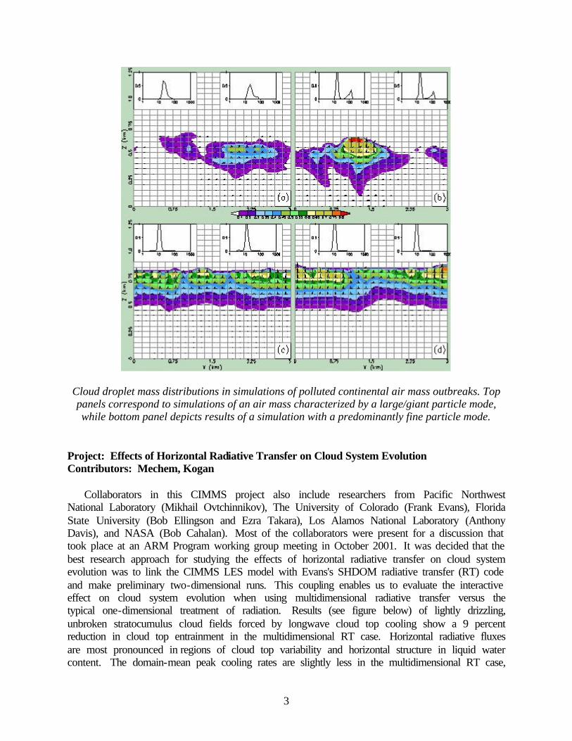
The development of a microphysics parameterization for stratiform clouds based on integral moments of the drop size distribution has continued. A valuable feature of this parameterization is the use of directly observable variables, such as radar reflectivity. For the purpose of model initialization, the latter can be obtained from the 24-hour routine millimeter cloud radar observations at the U.S. Department of Energy Atmospheric Radiation Measurement (ARM) Program Southern Great Plains (SGP) site. The results obtained during the last year include testing of a new regression analysis technique to improve the accuracy of representation of coagulation and sedimentation processes. We are now proceeding to the analysis of developed parameterizations and finding approaches to generalize them for a wider range of cloud systems. Such general parameterizations will provide a new powerful way to formulate cloud physics processes in numerical forecast models. Another thrust of the parameterization development effort is to study feedbacks between aerosol particle (AP) load, precipitation, and boundary layer thermodynamical parameters. In a series of large eddy simulation (LES) experiments simulating polluted continental air outbreaks over the ocean region, we investigated the effect of aerosol size distribution and the aerosol concentration vertical profile on marine stratocumulus drizzle production and cloud system dynamical structure. Our main conclusions to date are as follows:
(1) Large and giant AP descending into the cloud layer from the polluted layer above the
inversion significantly enhance drizzle production leading to attenuated turbulence, widening of the entrainment zone, decoupling of the subcloud layer, and accelerated stratocumulus breakup (see figure below).
(2) In a marine air mass modified by continental polluted air characterized predominantly by fine mode AP, precipitation was suppressed. The suppression was less if the pollutant particles were seeded from the polluted layer above the inversion.
(3) The feedbacks between polluted continental air mass outbreaks and drizzle production, positive for continental air masses characterized by a large/giant particle mode and negative for a fine particle mode, were enhanced in the presence of a wind shear across the inversion.
3
Cloud droplet mass distributions in simulations of polluted continental air mass outbreaks. Top panels correspond to simulations of an air mass characterized by a large/giant particle mode, while bottom panel depicts results of a simulation with a predominantly fine particle mode.
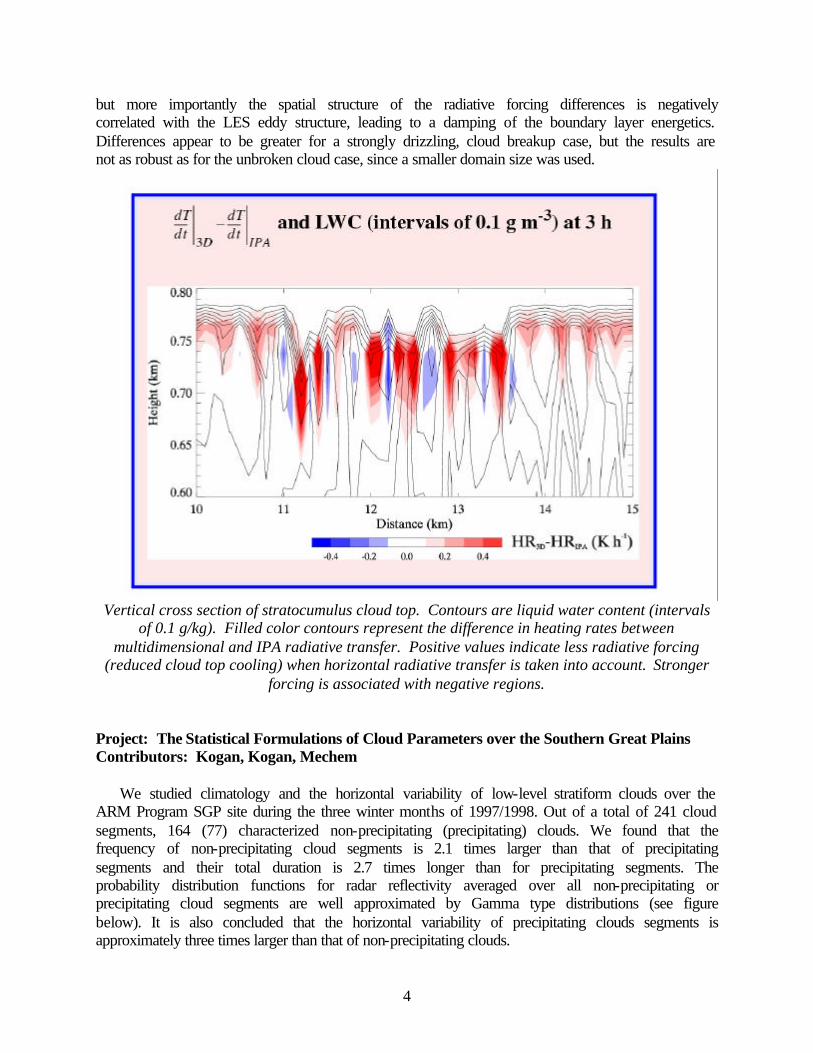
Project: Effects of Horizontal Radiative Transfer on Cloud System Evolution Contributors: Mechem, Kogan
Collaborators in this CIMMS project also include researchers from Pacific Northwest National Laboratory (Mikhail Ovtchinnikov), The University of Colorado (Frank Evans), Florida State University (Bob Ellingson and Ezra Takara), Los Alamos National Laboratory (Anthony Davis), and NASA (Bob Cahalan). Most of the collaborators were present for a discussion that took place at an ARM Program working group meeting in October 2001. It was decided that the best research approach for studying the effects of horizontal radiative transfer on cloud system evolution was to link the CIMMS LES model with Evans's SHDOM radiative transfer (RT) code and make preliminary two-dimensional runs. This coupling enables us to evaluate the interactive effect on cloud system evolution when using multidimensional radiative transfer versus the typical one-dimensional treatment of radiation. Results (see figure below) of lightly drizzling, unbroken stratocumulus cloud fields forced by longwave cloud top cooling show a 9 percent reduction in cloud top entrainment in the multidimensional RT case. Horizontal radiative fluxes are most pronounced in regions of cloud top variability and horizontal structure in liquid water content. The domain-mean peak cooling rates are slightly less in the multidimensional RT case,
4
but more importantly the spatial structure of the radiative forcing differences is negatively correlated with the LES eddy structure, leading to a damping of the boundary layer energetics. Differences appear to be greater for a strongly drizzling, cloud breakup case, but the results are not as robust as for the unbroken cloud case, since a smaller domain size was used.
Vertical cross section of stratocumulus cloud top. Contours are liquid water content (intervals
of 0.1 g/kg). Filled color contours represent the difference in heating rates between multidimensional and IPA radiative transfer. Positive values indicate less radiative forcing
(reduced cloud top cooling) when horizontal radiative transfer is taken into account. Stronger forcing is associated with negative regions.
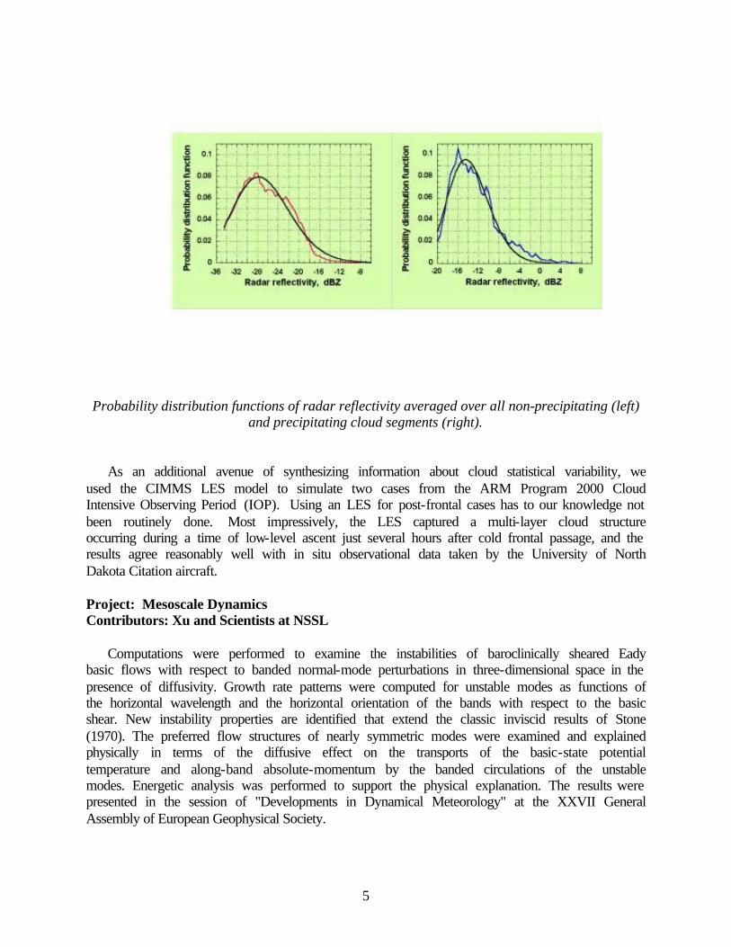
Project: The Statistical Formulations of Cloud Parameters over the Southern Great Plains Contributors: Kogan, Kogan, Mechem
We studied climatology and the horizontal variability of low-level stratiform clouds over the ARM Program SGP site during the three winter months of 1997/1998. Out of a total of 241 cloud segments, 164 (77) characterized non-precipitating (precipitating) clouds. We found that the frequency of non-precipitating cloud segments is 2.1 times larger than that of precipitating segments and their total duration is 2.7 times longer than for precipitating segments. The probability distribution functions for radar reflectivity averaged over all non-precipitating or precipitating cloud segments are well approximated by Gamma type distributions (see figure below). It is also concluded that the horizontal variability of precipitating clouds segments is approximately three times larger than that of non-precipitating clouds.
5
Probability distribution functions of radar reflectivity averaged over all non-precipitating (left)
and precipitating cloud segments (right).
As an additional avenue of synthesizing information about cloud statistical variability, we used the CIMMS LES model to simulate two cases from the ARM Program 2000 Cloud Intensive Observing Period (IOP). Using an LES for post-frontal cases has to our knowledge not been routinely done. Most impressively, the LES captured a multi-layer cloud structure occurring during a time of low-level ascent just several hours after cold frontal passage, and the results agree reasonably well with in situ observational data taken by the University of North Dakota Citation aircraft. Project: Mesoscale Dynamics Contributors: Xu and Scientists at NSSL
Computations were performed to examine the instabilities of baroclinically sheared Eady basic flows with respect to banded normal-mode perturbations in three-dimensional space in the presence of diffusivity. Growth rate patterns were computed for unstable modes as functions of the horizontal wavelength and the horizontal orientation of the bands with respect to the basic shear. New instability properties are identified that extend the classic inviscid results of Stone (1970). The preferred flow structures of nearly symmetric modes were examined and explained physically in terms of the diffusive effect on the transports of the basic-state potential temperature and along-band absolute-momentum by the banded circulations of the unstable modes. Energetic analysis was performed to support the physical explanation. The results were presented in the session of "Developments in Dynamical Meteorology" at the XXVII General Assembly of European Geophysical Society.
6
Project: Mesoscale Data Analyses and Data Assimilation Contributors: Xu and Scientists at NSSL
Doppler radar data assimilation. A theoretical formalism was derived for background error covariance functions applied to radial component winds projected onto the directions of radar beams. The derived covariance functions can be directly applied to optimal interpolations of radar radial winds on each conic surface of radar scans. They can be also used as influence functions for radial-wind analyses with zero background. The structures of these covariance functions are interpreted in terms of the influences of single-point observations to radial-wind analyses. The utility of these covariance functions are demonstrated by numerical experiments. The results show that using the derived error covariance functions improves analyses in data void areas especially in the vicinity of the radar.
Applied research was conducted to develop advanced dealiasing and 2dVar wind retrieval techniques for real-time Level-II radar data applications. Along with these studies and in collaboration with CIMMS scientists, a prototype system called Radar Wind Retrieval (RWR) package was installed together with the LDM (Local Data Manager) and WDSS-II (Warning Decision Support System II) systems on two NSSL workstations. This package has been running with real-time Level-II data (from KTLX in Oklahoma and from eight radars in New England) since June 2002. It produces real-time displays of the retrieved vector winds and makes available on-line data files (http://gaussian.gcn.ou.edu:8080/NewEngland and http://gaussian.gcn.ou.edu:8080/cgi-bin/product_ne.pl?KTLX). It has produced better than expected retrievals that have attracted attentions from a variety of potential users.
Further study of soil-vegetation physics with COAMPS and ARM Program data. In collaboration with scientists at NSSL and NRL, comprehensive surface observations and soil-vegetation data collected at the Oklahoma ARM Program SGP Central Facility were utilized to test the soil-vegetation model installed in the Navy's Coupled Ocean/Atmospheric Mesoscale Prediction System (COAMPS). Although the early installed version of soil-vegetation model was recently upgraded by introducing a skin temperature layer similarly to that in the ECMWF model, the upgraded model did not solve all of the previously identified problems. In particular, the upgraded model still tended to over-estimate the evaporation over wet soils, while under-estimating the evaporation over dryer soils. Two possible sources of the problems were identified; that is, (i) the neglect of soil water infiltration into the deep layer in the model (after rain or dew formation) and (ii) the neglect of evaporation within the soil pore spaces in the model. Parameterizations are introduced to represent these processes in the model. Tested with the ARM measurements, these parameterizations are found to be effective in correcting the problems. This made the model suitable for future COAMPS land-surface data assimilation. Currently this soil model is being evaluated at NRL Monterey for possible use in the operational version of COAMPS.
Duct parameter data assimilation. Low-altitude radar electromagnetic propagation can be strongly affected by the presence of surface-based and elevated ducts formed by capping inversions in the atmospheric boundary layer. The 2dVAR package developed for duct parameter analysis was upgraded (with the direct matrix inversion algorithm replaced by a variational descending algorithm suitable for large-scale computations). The upgraded package was provided to NRL and U.S. Navy Space and Naval Warfare (SPAWAR) for further tests and applications.
7
Project: Convective Boundary Layer Vertical Vortices Contributors: Kanak, Lilly, Snow, Fiedler
Three-dimensional, two-meter resolution boundary layer large eddy simulations have been conducted, the results of which exhibit vertical vortices with dust devil scale motions. This is likely the first LES to resolve and simulate dust devil-type circulations. The vortices have structure and intensity comparable to those of dust devil field observations by Sinclair and others. These results were presented at the International Symposium on Boundary Layers and Turbulence in The Netherlands in July 2002. Related work with Dr. Brian Fiedler, using numerical simulations of Rayleigh-Benard convection to study vertical vortices, was also completed and published. Project: Martian Dust Devils Contributors: Kanak, Cantor
Collaborative work continues with Bruce Cantor (and previously, Ken Edgett) at Malin Space Science Systems to study Martian dust devils. An outline for a research article (possibly to be submitted to the Journal of Geophysical Research) has been completed and work is continuing on the paper. Project: Idealized Convective Elements and Vertical Vortex Formation Contributors: Shapiro, Kanak
Study of the formation of vertical vortices in elliptical buoyant bubbles is being conducted in collaboration with OU Professor Alan Shapiro. The results of this work were published in the Journal of the Atmospheric Sciences in June 2002. Analytical and numerical work are described that demonstrate the formation of vertical vortex circulations in isolated elliptical bubbles in quiescent flows. Project: Tornadogenesis Contributors: Rasmussen, Gilmore
In examining the Dimmitt, TX, tornadic supercell observed during VORTEX, it was found that a pair of counter-rotating vortices of several-kilometer scale formed in low-levels, the cyclonic member being the incipient Dimmitt tornado. The vortex pair was strongly associated with the descent of a "blob" of precipitation from the echo overhang in the right rear portion of the storm.
After making this observation in one supercell, several additional tornadic and non-tornadic supercells were examined. Five observed tornadoes were associated with the descent of precipitation blobs, with several additional blobs being associated with low-level vortex genesis, but not tornadoes. One low-precipitation supercell did not exhibit any blob descent, and did not exhibit any periods of pronounced low-level vortex genesis.
8
Project: Reassessment of the Percentage of Tornadic Mesocyclones Contributors: Trapp, Stumpf, Manross
A large set of data, collected over an 8-year period, was analyzed to estimate the percentage of mesocyclonic thunderstorms that spawn tornadoes. A total of 5,322 mesocyclones – areas of rotation of several-kilometer diameter within vigorous thunderstorms – were objectively identified using data from operational Doppler (WSR-88D) radars across the United States. It was found that only 25 percent were associated with tornadoes. Expressed in terms of the height above ground level (AGL) of their “bases” or lower boundary, 15 percent of the mesocyclones whose bases were between altitudes of 3 and 7 km (i.e., mid-altitude) were tornadic, while 40 percent of the mesocyclones whose bases were at altitudes less than or equal to 500 m (i.e., low-altitude) were tornadic.
Our current study updates mesocyclone statistics based on 1970s data collected by research Doppler radars, primarily on thunderstorms in central Oklahoma. Such statistics are important since the presence of a Doppler radar-detected mesocyclone is frequently used by forecasters to predict future tornado development. Moreover, because the lowest altitude at which the operational radars can detect a mesocyclone increases with increasing distance from the radar, these new statistics that are a function of mesocyclone altitude can begin to let forecasters place better confidence bounds on their tornado warnings, given the mesocyclone altitude. Project: The Formation and Climatological Distribution of Tornadoes within Quasi-
Linear Convective Systems Contributors: Trapp, Stumpf, Savageau, Manross
Efforts during the year have been concentrated on the climatological component of this project. Specifically, we have classified all tornadoes reported in the contiguous U.S. in 1999 (and many in 2000) by respective parent storm type: “cell,” quasi-linear convective systems (QLCS), or “other.” This analysis complements a like classification for tornadoes reported in 1998, and is allowing us to compute the geographical, seasonal, and temporal distributions of the sampled tornadoes, as a function of the parent storm. Additionally, we are stratifying the QLCS tornadoes according to damage-based intensity (Fujita scale), estimated duration, number of fatalities, dollar amount of property damage, and other factors. Statistical tests have been applied to these and other results to determine their robustness.
To help characterize the larger-scale environment that supports the formation of QLCS tornadoes, initial work has begun on the construction of composite thermodynamic and wind profiles, using data from radiosonde observations taken in proximity to a sub sample of tornadic QLCSs in our dataset. Project: Thunderstorm Electrification Modeling Contributors: Mansell, Kuhlman, MacGorman, Ziegler, Straka
Recent efforts have focused on simulating the dynamic, microphysical, and electrical characteristics of observed thunderstorms. Our model was upgraded to include an explicit treatment of small atmospheric ion processes. One major case being studied is a thunderstorm that was observed during the Severe Thunderstorm Electrification and Precipitation Study (STEPS) in 2000. This 29 June 2000 tornadic storm has been a primary focus of the STEPS
9
community in terms of radar and lightning analysis, providing excellent opportunities for comparison with model results. Two other cases that are being simulated are the 10 July 1996 storm from the Stratospheric-Tropospheric Experiment: Radiation, Aerosols, and Ozone (STERAO) field program and the 9 August 1991 storms from the CaPE (Convection and Precipitation Electrification) field program in Florida.
We have also begun investigation of relationships between electrical and non-electrical characteristics of simulated storms. This investigation was begun with idealized storm environments and will later be expanded to storms simulated from observed environments. Project: Effect of Mesocyclones on the Storm's Charge Distribution Contributor: MacGorman
We obtained a few soundings in mesocyclones to supplement the one sounding we had obtained previously with lightning mapping data (in 1998 during MEaPRS). In all cases in which the balloon was in strong updrafts in a mesocyclone, significant charge density was absent below a height of approximately 8 km MSL, in agreement with the mesocyclone effect hypothesized by MacGorman et al. (1989). Outside of the mesocyclone, charge was present at the lower altitudes where it usually is observed. Our initial hypothesis, needing testing by model studies and with additional data, is that the strong updraft shifts graupel formation to higher altitudes, and the vorticity and strong upper-level divergence combine to interfere with recirculation of graupel into the updraft. Together these two effects prevent charge from occurring at lower altitudes in mesocyclone updrafts. Project: Inverted-Polarity Storms Contributor: MacGorman
By “inverted-polarity storm” and “inverted-polarity electrical structure”, we mean that the normal polarities of charge in two or more vertically separated regions of a storm are reversed. One hypothesis that has been suggested to explain why storms produce positive, instead of the usual negative, cloud-to-ground lightning is that the charge structure of the storm is inverted. Preliminary analyses both of our soundings and of the New Mexico Tech lightning mapping data suggest that inverted structure occurs in some storms. However, it does not appear to be true of all storms that produce many positive cloud-to-ground lightning flashes. Additional data analysis is needed to verify that storms can have inverted charge structure and to try to understand why. Plans – FY03 Project: Severe Storm Studies Contributor: Doswell
Research is proposed in several areas:
Numerical modeling study of the time-dependent behavior of convection. This work involves the use of a 3-d cloud model based on the ARPS model, developed by Dr. Daniel Weber. The goal is to determine how environmental factors, notably the forcing that initiates
10
deep convection and the environmental wind and thermodynamic profiles control the time-dependent behavior of deep convective storms.
Evaluation of synoptic-scale controls on tornado outbreaks. A classic forecasting problem is whether or not a particular synoptic-scale is going to produce a significant outbreak of tornadoes. Although much work has been done on individual case studies over the decades since tornado forecasting began in the 1950s, this issue remains problematic for forecasters. In collaboration with Mr. Richard Thompson and Mr. Roger Edwards of the Storm Prediction Center, an effort to clarify this will be undertaken with a large number of case studies, including “null’ cases where a significant tornado outbreak did not occur. We hope to determine whether or not there is a clear signal at synoptic scales that would permit an improvement in forecasting significant tornado outbreaks.
Societal impacts and interdisciplinary research. In collaboration with Prof. Scott Greene (OU Geography), a project is being considered that will undertake one of several candidate projects aimed at assessing the societal impact of weather information. A graduate student has been identified and once the project is determined, a proposal will be written to seek funding support for this work.
Automated tornado video photogrammetry. Even with pairs of mobile Doppler radars, tornadic wind fields near the surface are not readily observed. Therefore, many details of the time- and space-dependent wind field in tornadoes have remained unknown near the surface, where structures exist. The proliferation of inexpensive video cameras means that many tornadoes are captured on video during their interaction with human structures. The data that can be derived from photogrammetric analysis of these videos could be revolutionary in adding to our understanding of tornadic airflow, but there remains a need for a system that would provide rapid photogrammetric analysis of such videos. Given the rapid progress in automated image analysis, it should be possible to use these videos to provide tangential wind speed estimates at hundreds of points in space at high temporal frequency. In collaboration with Dr. Erik Rasmussen (CIMMS), funding will be sought to develop such an analysis system.
Work is also underway on the development of a revised perspective on parcel theory and buoyancy. This work is nearing completion. Project: Parameterization of Cloud Microphysics and Radiation Contributors: Kogan, Yi, Belochitsky
We plan to complete the development of an integral moment microphysics parameterization for stratiform clouds. The parameterization development work will be described in a Masters thesis to be completed in the fall of 2002. We will continue the analysis of the feedbacks between aerosol size distribution, its vertical load, drizzle, boundary layer thermodynamical parameters, and surface winds. We will study the effect of these parameters on cloud microstructure and aim to identify the parameter set that determines the cloud drop concentration. A separate part of this research will be directed at defining factors that control cloud base height and visibility in the marine boundary layer.
11
Project: Effects of Horizontal Radiative Transfer on Cloud System Evolution Contributors: Mechem, Kogan
We aim to increase our confidence in the results for the unbroken planetary boundary layer cloud case and further explore cases of broken cloud, where the evolutionary differences arising from the use of multidimensional radiative transfer should be more pronounced. Our goal is to investigate which types of clouds would benefit by accounting for forcing arising from horizontal radiative transfer. Project: The Statistical Formulations of Cloud Parameters over the Southern Great Plains Contributors: Kogan, Kogan, Mechem
In the next year the climatology of analyzed cases will be expanded to include two more years of observations. The characteristic empirical distributions of radar reflectivity for precipitating and non-precipitating clouds will be derived in a form convenient for use in mesoscale prediction models. Results from the two LES model simulations will be analyzed to show whether substantial variability is present at frequencies higher than what the cloud radar is able to resolve and to what degree the fixed turbulence assumption is valid for transforming time-height cloud radar data into space-height. In addition, the point correlation between model-derived reflectivity and cloud parameters such as liquid water will be explored. For situations where a good correlation exists, statistical measures of variability from the observational radar data could then be used as a direct proxy for variability in prognostic mesoscale model fields. Project: Mesoscale Dynamics Contributors: Xu and Scientists at NSSL
We will continue our current theoretical study on hybrid baroclinic-symmetric instabilities and examine the non-modal growths of perturbations in terms of singular vectors. We will also examine the energetic aspects of the hybrid baroclinic-symmetric instabilities for different boundary conditions (free-slip versus non-slip). Project: Mesoscale Data Assimilation Contributors: Xu and Scientists at NSSL
We will continue our current studies on mesoscale data assimilation in the following areas by: (a) developing advanced formalisms for mesoscale and storm-scale data assimilation using Doppler radar in combination with other observations; (b) improving techniques in Doppler radar data quality control and related real-time applications; and (c) developing error covariance estimation using innovation techniques. Project: Convective Boundary Layer Vertical Vortices Contributors: Kanak, Lilly, Snow, Fiedler
Further analyses of the high-resolution simulation results, and expansion to consider the effects of ambient winds and wind shears on vertical vortices are in progress. Two computer algorithms to detect and quantify vertical vortices in the run-time simulations are being explored.
12
The first follows the work of McWilliams that employs an algorithm designed to mimic the “human decision making process” for the recognition of vortex patterns. The second is based on the technique of Jeong and Hussein, in which the eigenvalues of the tensor, S2+O2 (where S+O is equal to the velocity gradient tensor) are evaluated and contoured to indicate the presence of a vortex. In addition, existing mobile radar, mobile mesonet, and sounding data from dust devils and their environments will be analyzed. This observational data and the analyses thereof may serve as a thesis project for a Master's degree student. Project: Idealized Convective Elements and Vertical Vortex Formation Contributors: Shapiro, Kanak
A proposal to the NSF is in preparation in which it is proposed to further explore the formation of vertical vortices in ellipsoidal convective elements. The inclusion of the effects of ambient winds, surface heat fluxes, variations in thermal stratification and the effects of viscosity will be investigated. Preliminary numerical simulations, including the effects of ambient winds, are currently being conducted. Project: Cirrus Outflow Dynamics Associated with Thunderstorms Contributors: Straka, Kanak, Lilly, Zrnic
A proposal for numerical and observational studies of thunderstorm cirrus outflow dynamics is being prepared for submission to the NSF. The role of microphysical processes, as examined through numerical simulation and possibly through the use of polarimetric radar data, will be emphasized. Project: Tornadogenesis Contributors: Rasmussen, Gilmore
Certain common observations in several supercells have provided evidence for a conceptual model of tornadogenesis. This process will be investigated using idealized numerical modeling, and reported using observations of the Dimmitt tornadic supercell. It is believed that tornadogenesis results from locally intense downdrafts at the supercell rear flank that penetrate a highly sheared local environment. Additional supercells will be investigated for the presence of blob behavior, and this will be reported in a formal contribution. Finally, we will complete work that analyzes the angular momentum budget of tornadoes observed during VORTEX with mobile Doppler radar. Project: Reassessment of the Percentage of Tornadic Mesocyclones Contributors: Trapp, Stumpf, Manross
The mesocyclone sample produced using our methodology is exaggerated when compared to the mesocyclone sample due to Burgess et al. (1979) and others. This is an artifact of the Mesocyclone Detection Algorithm (MDA) and associated verification procedure. Indeed, a new or different mesocyclone is defined for each radar volume scan within which the operational criteria are met. Hence, a single, manually identified mesocyclone that persists for one hour equates to 12 mesocyclones using our methodology, assuming 5-minute volume scans (and of
13
course a persistent operational mesocyclone). We are interested, however, only in percentages, rather than raw numbers of mesocyclones, and so comparison of our results with those of Burgess et al. should still be meaningful. Nevertheless, work is currently underway to piece together individual MDA detections to form single mesocyclones of appropriate duration. Project: The Formation and Climatological Distribution of Tornadoes within Quasi-
Linear Convective Systems Contributors: Trapp, Stumpf, Savageau, Manross
A task to be initiated is the computation of radar-based attributes of the tornadic and non-tornadic QLCSs in our dataset. Relevant Doppler radar data will be processed and analyzed, using the suite of automated algorithms developed at CIMMS and NSSL. Algorithmic output showing, for example, the size distribution of the parent vortices of QLCS tornadoes will help characterize tornadic QLCSs, and also point to any unique radar signatures that may have nowcasting utility. Project: Thunderstorm Electrification Modeling Contributors: Mansell, Kuhlman, MacGorman, Ziegler, Straka
Plans for the coming year include continuing the current simulation study cases and initiation of new cases. Data from the STEPS lightning mapping array will be used to test the lightning production in the model. The cases that provide good simulations of the observed lightning behavior will also be used to investigate relationships between lightning and other storm characteristics such as graupel mass and updraft volume. 2. Forecast Improvements Progress – FY02 Project: Implementation of CIMMS Stratiform Cloud Parameterization Into a Regional
Forecast Model Contributors: Mechem, Kogan
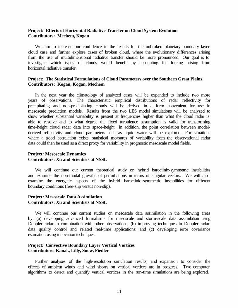
A case study of summer season planetary boundary layer cloud has been simulated using COAMPS (U.S. Navy's Coupled Ocean/Atmosphere Mesoscale Prediction System). Results using a horizontal grid of 2 km show a strong diurnal cycle and fair agreement with SSM/I liquid water path (see figure below). The finer the model resolution, the more important it is to use a more realistic microphysical parameterization. When drizzle processes are included, the model produces a transition from a well-mixed boundary layer topped by unbroken stratocumulus into a more potentially unstable, convective boundary layer regime. The transition produced is the mesoscale model analogue to the drizzle-induced cloud breakup demonstrated in LES studies. The convective regime contains appreciable vertical velocity, linked to a weak decoupling of the cloud and subcloud layers, with the characteristic of an ensemble of cumulus updrafts. The
14
results of the study demonstrate the potential of the CIMMS cloud physics parameterization in improving regional forecasting of stratocumulus cloud systems.
Comparison of COAMPS simulation results from 18 UTC 25 July 1997 showing cloud system
mesoscale structure. Liquid water path (LWP; g/m²) and cloud water (Qc; kg/kg) are plotted for drizzling (KK) and non-drizzling (ND) experiments. (a) KK LWP; (b) ND LWP; (c) and (d)
vertical cross-section of Qc along lines A1-A1' and A2-A2' indicated in (a) and (b). Project: Collaborations between the Research and Operational Forecasting Communities Contributors: Baldwin, Kain
Active interactions between CIMMS, NSSL and SPC continued with daily map discussions, individual research projects, and an experimental forecasting and research program during spring 2002. CIMMS/NSSL scientists prepared and delivered seminars to SPC and Norman WFO forecasters focusing on the interpretation of numerical model guidance. These seminars were presented as part of semi-annual SPC training programs. CIMMS/NSSL scientists also worked with SPC technology infusion specialists to extract code for parameterization of convective activity from NWP models and insert it into the SPC's sounding analysis routines. SPC forecasters now have the capability to process any sounding (observed, model-derived, or hand-crafted) through the Betts-Miller-Janjic and Kain-Fritsch convective schemes. And, CIMMS/NSSL scientists participated in the annual Spring Program that was conducted in coordination with the International H2O Experiment (IHOP).
15
CIMMS/NSSL scientists also participated in the COMET program. They served as guest lecturers at COMET symposia on several occasions during the year. This program plays a critically important role in educating and training NWS personnel by transferring knowledge and applications from the research community to the operational forecast community. Project: Objective Analysis Studies Contributors: Spencer
Analytic observations have been used to compare the traditional and triangle methods for the objective analysis of scalar variables. The traditional method for objective analysis assigns a grid point value based on the distance from the particular grid point to each member of the set of observations. Spatial derivatives subsequently are derived by applying a finite differencing scheme to the field of gridded observations. The triangle method for objective analysis calculates the spatial derivatives directly from each set of non-overlapping triangles that are formed by the observations, and the derivatives are assigned to the triangle centroids. By calculating spatial derivatives directly from the observations, the triangle method bypasses the need for finite differencing.
Results indicate that the traditional method for the analysis of a scalar variable is superior to the triangle method for scalar analysis because the simple averaging involved in creating the triangle centroid estimates of the scalar exposes the triangle analysis to the potential for significant damping of the input field. Gradient and Laplacian fields computed from the triangle method, however, are generally superior to those derived by the traditional method, which tends to force all the gradient information into the gaps between observing stations.
To overcome the deficiency of the triangle method's ability to produce an acceptable scalar analysis and the deficiency of the traditional method's ability to produce an acceptable derivative analysis, a variational objective analysis scheme has been developed that combines the best aspects of the triangle method with those of the traditional method. Analyses of the scalar and its spatial derivatives from the variational analysis scheme are generally superior to analyses from both the traditional and triangle methods. Project: Polarimetric Radar Observations of Downburst-Producing Thunderstorms Contributor: Scharfenberg
Polarimetric radar data of several downburst-producing thunderstorms have been examined. Very high local values of specific differential phase were frequently found to coincide with the first appearance of a divergent low-level radial velocity couplet. Considered along with high reflectivity factor and low differential reflectivity values, this indicated the bulk presence of a hail and rain mixture at low levels within the downdraft column. These observations were corroborated by a decrease in co-polar correlation coefficient toward the ground, indicating an increasing mixture of hydrometeor types.
Previous modeling studies have shown that melting hail is a large contributor to downward acceleration, enhancing wet microbursts. Wind tunnel studies revealed that melting hailstones form a water torus during their descent (see figure below), with frequent shedding of water drops of various sizes. Therefore, an increase in the specific differential phase was expected, as shed drops produced a large number of new oblate hydrometeors. Bulk hydrometeor characteristics deduced from these polarimetric radar observations were compared to these model and wind

16
tunnel studies. It was surmised that polarimetric radar signatures consistent with melting hail were observed, and diabatic cooling from this phase change likely contributed to these downbursts.
Wind tunnel model simulation of a melting hailstone in free fall. The meltwater forms a "torus" near the equator of the falling particle, yielding an oblate overall shape. Numerous water drops
of varied size are shed from the melting hailstone during its descent. Project: NOAA New England Forecasting Pilot Program: High Resolution Temperature
and Air Quality Contributors: Kain, Baldwin, Yussouf
A major goal of the Temperature Forecasting Pilot Project is to create and test new methods to improve the forecasts of 2-m temperature and dewpoint temperature out to 2 days from an ensemble of model forecasts. For the ensemble being investigated as part of this pilot project, we are using several different forecast models and many different model initial and boundary conditions. It is believed that by taking these different forecasts of the atmospheric evolution, and applying a simple bias correction to account for mean model error, we can provide improved temperature and dewpoint temperature forecasts for the New England region. Currently, this research ensemble is running continuously so that forecast data can be analyzed later. Project: Intermountain Precipitation Experiment Contributors: Schultz, Trapp, Burke
The Intermountain Precipitation Experiment (IPEX) is a field and research program designed to improve the understanding, analysis, and prediction of precipitation and precipitation processes in complex terrain. The field stage of the experiment occurred during the winter of 2000 and was led by a CIMMS scientist (Schultz). During the past year, CIMMS research focused on examining IOP 4 and writing a summary manuscript about this field project that was subsequently published in the Bulletin of the American Meteorology Society. IOP 4 occurred on
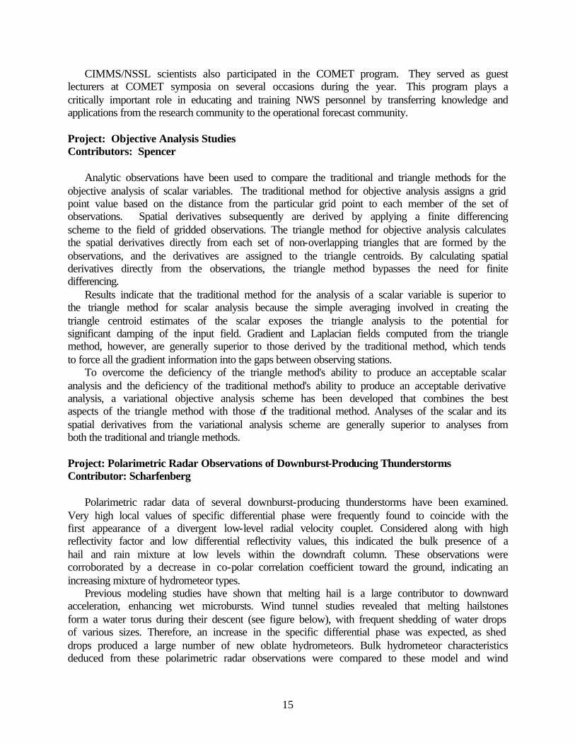
17
14 February 2000 and was an unusual severe storm during February in Nevada, Idaho and Utah, with a 71 mph wind gust in Cache Valley and a fatality in Brigham City due to high winds. The convection associated with this Valentine's Day event was well sampled by many research platforms. Examining the case for the purposes of the current study, a glance at the reflectivity loop gives the impression that this was a clear-cut bow echo. However, like many of the bow echoes studied thus far, its origin and structure were very complex. During its peak intensity, the leading edge of the system consisted of several strong, individual cells, each with mesocyclones. These storms produced six reported tornadoes in the vicinity of Pocatello, ID, and some of the velocity signatures from KSFX were unmistakably tornadic (see figure below). On the larger scale, though, the cells were part of a bow shaped convective system that moved as fast as 56 kts.
It may be best to describe this event as a bow echo with short-lived supercells along its leading edge. The bow echo was said to originate at 2107 UTC when the first 40 dBz echoes appeared along the pre-existing arcing line of precipitation. Essentially, the bowing reflectivity signature was already there before the development of strong convective updrafts. The bow then flattened somewhat, but the convection intensified and the stratiform region expanded. Overall, there was just enough bow character to classify this as a bow echo. The initiation is being classified as that of a squall line bow-echo because the individual cells formed along a line and did not merge with each other as they would in the cluster or merger modes. It is unclear whether the strong rear-inflow was truly an RIJ or was mostly background environmental wind. The 0-5 km shear was 88 knots on the 1800 UTC Boise, ID, sounding. It is remarkable that there was sufficient convective available potential energy in Idaho in February to support upright convection in the face of such strong shear.
Tornado Vortex Signature detection of Chubbuck tornado 2252 UTC.
18
Project: Warning Decision Making Analysis Contributors: Magsig, Wood, Yu, Hoggard, Said
Warning decision-making analysis continues to be an area of active collaborative research between CIMMS and the NWS Warning Decision Training Branch. CIMMS researchers have been heavily involved in WDTB workshops on analysis of warning decision-making. The workshops incorporate subject matter experts and warning forecasters from around the country to discuss many facets of the warning decision making process. The workshops are an opportunity to share knowledge and experience as well as to test new experimental techniques for issuing and verifying warnings. The year's workshops have investigated severe weather, flash flooding, winter weather, and the human side of the warning decision making process. Project: Warning-Related Forecast Improvements Contributors: Magsig, Wood, Yu, Hoggard, Said
The warning decision making process is multi-faceted, often being improved directly by unique observing systems, analysis tools, data analysis techniques, human factors, or improvements in forecast verification. Progress is being made in warning-related forecast improvements with the application of unique radar and satellite sensors and new data analysis techniques. OU’s Doppler On Wheels (DOW) radar has been used to illustrate the sampling limitations of operational radar and the potential improvement in warning decision-making using new tools and knowledge gained from analysis of their data. In the 3 May 1999 Oklahoma radar analysis, significant tornado damage was correlated with debris signatures in the reflectivity fields to illustrate a new relationship that has operational implications for detecting tornadoes producing significant damage. In another study using the DOW data, the structure and evolution of the hook echo was studied as it relates to tornadogenesis in multiple tornadic storms.
High-resolution satellite data was another unique sensor source used in an analysis of the 3 May tornado outbreak. The satellite data was used to develop a new technique for detecting tornado tracks remotely that can improve the verification of tornado forecasts. In addition to new remote sensing analysis, data analysis techniques have been developed to improve the ability to ensemble precipitation forecasts and improve warning decision-making using mesoscale models and other mesoscale environmental data. Project: Warning Simulation Contributors: Magsig, Wood, Yu, Hoggard, Said
CIMMS researchers continue to use simulations to study warning decision making for severe convective weather and winter weather. The simulation capabilities have been expanded to begin including decision support systems such as the System for Convection Analysis and Nowcasting (SCAN) and version 2 of the Flash Flood Monitoring and Prediction System (FFMP2.0). This has allowed investigation into flash flooding decision-making and the role of these systems in providing guidance to the forecaster.
CIMMS scientists have also collaborated with WDTB on research into optimal learning with the use of simulations. The research draws heavily from the aviation and private sector studies on how to use simulations in a variety of ways to improve performance. A format for preparing effective simulations was established using learning objectives, evaluation, feedback, and
19
experimental warning techniques. The structure was applied to four challenging severe weather events with severe hail, wind, and tornadoes to better understand how to maximize learning from the use of structured simulations. Project: Multiple-Radar Severe Storm Analysis Program (MR-SSAP) Contributors: Stumpf, Smith, Manross, Thomas, McCoy
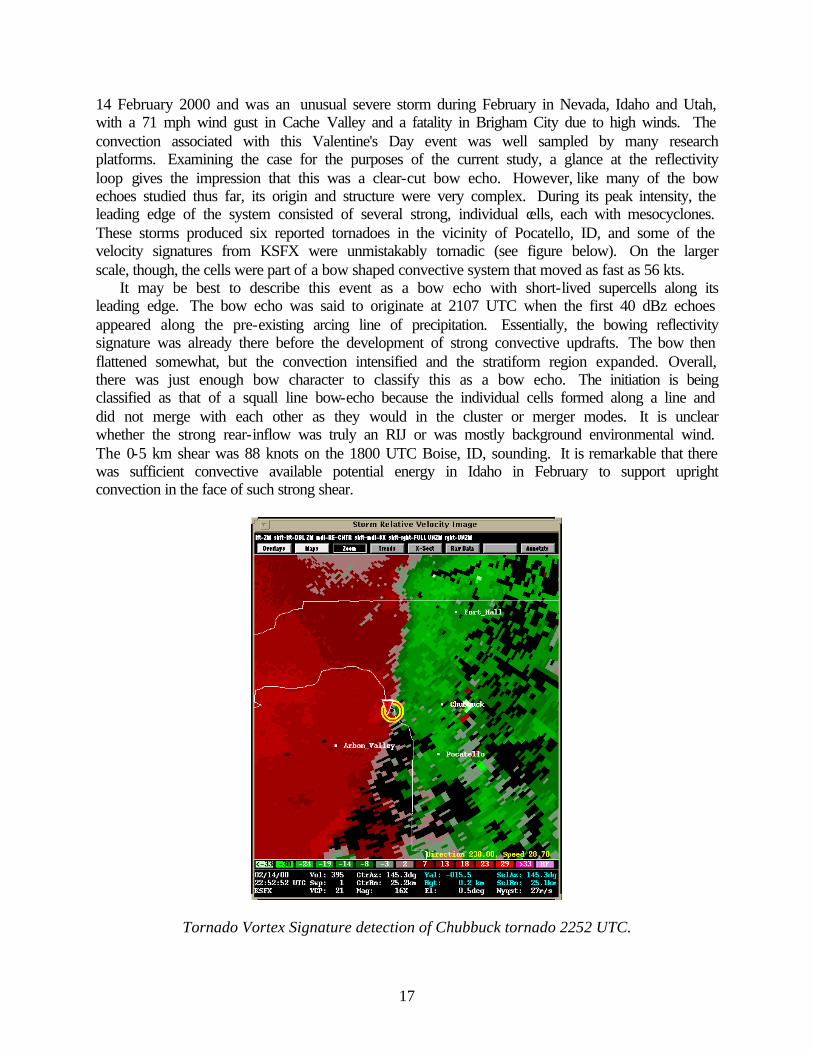
CIMMS has played the primary role in the prototype development and evaluation of severe weather applications used to analyze storm information using Doppler radar. During the previous year, CIMMS scientists continued to make improvements to these algorithms. Most severe weather algorithms have been designed for use with a single-radar data source. Our research has shown that effective warning decisions can only be made via the integration of information from many sources, including input from multiple remote sensors (multiple radars, mesoscale models, satellite, lightning, etc.). Therefore, the traditional single-radar sever weather algorithms are being updated to take advantage of additional data sources in order to reduce the uncertainty of the measurements and increase the accuracy of the diagnoses of severe weather.
The Multiple-Radar Severe Storms Analysis Program (MR-SSAP) for the Warning Decision Support System - Integrated Information (WDSS-II) has been initially developed. The original SSAP was the CIMMS-developed algorithm system that included the Storm-Cell Identification and Tracking (SCIT) algorithm, the Hail Diagnosis Algorithm (HDA), the Mesocyclone Detection Algorithm (MDA), the TVS Detection Algorithm (TDA), and the Damaging Downburst Prediction and Detection Algorithm (DDPDA). Each of these operated using only single-radar data (near-storm environment, NSE, data from the mesoscale model was also integrated into the original SSAP). The MR-SSAP extends the concepts of all five of these algorithms into the multiple-radar, multiple-sensor realm. During the past year, we have developed the Multiple-Radar SCIT (see figure below) and HDA algorithms that we believe will lead to improvements in understanding severe storms. New two-dimensional high-resolution (in time and space) hail algorithm and hail swath products have been developed. The WDSS-II facilitated the development process of the algorithms.
Multiple-Radar SCIT Output from 20 May 2001.
20
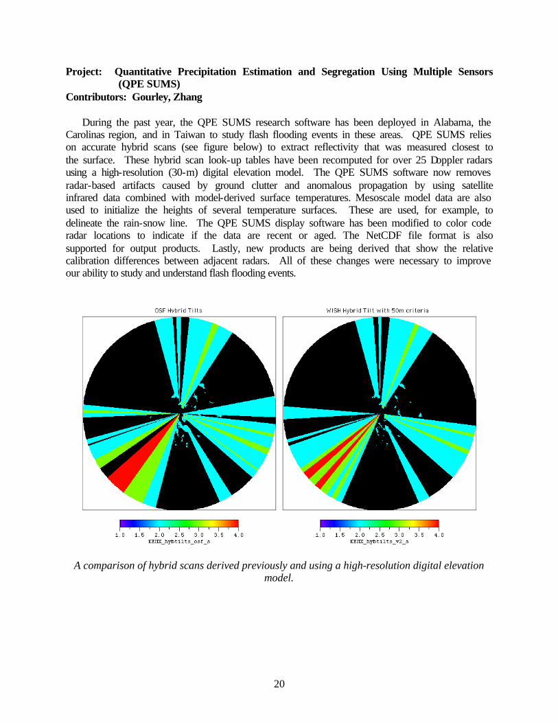
Project: Quantitative Precipitation Estimation and Segregation Using Multiple Sensors (QPE SUMS)
Contributors: Gourley, Zhang
During the past year, the QPE SUMS research software has been deployed in Alabama, the Carolinas region, and in Taiwan to study flash flooding events in these areas. QPE SUMS relies on accurate hybrid scans (see figure below) to extract reflectivity that was measured closest to the surface. These hybrid scan look-up tables have been recomputed for over 25 Doppler radars using a high-resolution (30-m) digital elevation model. The QPE SUMS software now removes radar-based artifacts caused by ground clutter and anomalous propagation by using satellite infrared data combined with model-derived surface temperatures. Mesoscale model data are also used to initialize the heights of several temperature surfaces. These are used, for example, to delineate the rain-snow line. The QPE SUMS display software has been modified to color code radar locations to indicate if the data are recent or aged. The NetCDF file format is also supported for output products. Lastly, new products are being derived that show the relative calibration differences between adjacent radars. All of these changes were necessary to improve our ability to study and understand flash flooding events.
A comparison of hybrid scans derived previously and using a high-resolution digital elevation model.
21
Project: SCIT Improvements Contributor: McCoy
In an effort to improve the performance of the CIMMS Storm Cell Identification and Tracking (SCIT) algorithm, modifications were made to its vertical association (VA) process. This involved the addition of a new vertical-merge technique that allows for the merging of 3D detections that overlap vertically, which is not permitted in the current algorithm. Test results using Doppler radar data from five storm cases show that the enhanced SCIT algorithm produced fewer VA failures than a baseline (unmodified) version of the algorithm, with the average failure rate (per storm case) decreasing from 25 to 17 percent (on a volume-scan scoring basis). The impact of the new technique on the time association (TA) process was also evaluated, with the enhanced SCIT algorithm producing, on average, 52 percent fewer TA failures compared to the baseline algorithm. Given the relatively small magnitude of change to the algorithm and the substantial reductions in both VA and TA failures, the new vertical-merge technique will likely be used for future storm-scale research projects. This project has been completed. Project: Three-Dimensional Multiple Radar Reflectivity Mosaic Contributors: Zhang, Xia, Calvert, Langston, Gourley
During the previous year, we developed research software that will produce a three-dimensional mosaic of radar reflectivity data. This software represents an analysis tool that is unique, giving researchers a new way to analyze Doppler radar data that may lead to forecast improvements. For example, this software will allow CIMMS scientists to analyze reflectivity data on isothermal surfaces. This software also has the capability to allow scientists to easily develop additional severe storms algorithms (e.g., identification, tracking and alert). The code for creating spherical-to-Cartesian coordinate transformation matrices is generalized and the software can be used for many types of Doppler radars. Project: National Basin Delineation Project Contributors: Cox, Kuhnert, Slayter, Arthur
Beginning in 1999, CIMMS and NSSL collaborated with the USGS Earth Resources Observation Systems (EROS) Data Center (EDC) to begin a unique study of flash flooding in the conterminous U.S., Puerto Rico, and Guam. This research project first required scientists to delineate all flash flood basins across this domain. Once the basin information was created, researchers calculated average basin rainfall rates and accumulations from radar precipitation estimates within each basin. These calculations were used to determine where and when flash flooding occurred.
The basin delineation was performed using the ArcView and ARC/INFO Geographic Information Systems (GIS), and was based on digital elevation data from the USGS National Elevation Dataset (NED). Produced at the EDC, the NED is a seamless mosaic of the highest resolution, best-quality elevation data for the U.S. Delineated basins and streams were then mosaiced for many Doppler radars in the country, with the exception of those sites in Alaska and Hawaii. Basins were attributed by county, county warning area, corresponding River Forecast Center, stream name (as available from the EPA/USGS National Hydrography Dataset – NHD),
22
intersection with lakes or reservoirs, area, and latitude/longitude of centroid and basin outlet, among others.
The center point of each 1-degree by 1-kilometer radar bin was assigned the ID of its corresponding basin. These assignments are used to determine the precipitation estimates to use for each average basin rainfall calculation. Basins not associated with a radar bin center point were iteratively merged with the next upstream basin until the new basin contained at least one radar bin center point. Similarly, basins smaller than two square miles were iteratively merged with the next upstream basin until the new basin was greater than two square miles.
This project has been completed. Project: Arizona Summertime Radar Climatology Contributors: Heinselman, Schultz
Previous studies, based primarily on low-resolution radar, lightning, and terrain data, show that elevated terrain influences the climatological diurnal precipitation cycle in central Arizona. Also, such studies show that summer precipitation in Arizona occurs intermittently as "bursts", periods of widespread rainfall, and "breaks", periods of little-to-no rainfall, owing to variations in the synoptic-scale pattern. In the present study, high resolution (1-km) radar data and digital terrain data show that within a burst, storms may initiate over a variety of elevated terrain features and either evolve mostly over mountains in the afternoon and over Phoenix during the evening. Such variations in reflectivity regime appear related to the tropospheric moisture, wind shear, and wind direction profiles at Phoenix, and lifting mechanisms available on a given day (e.g., diurnal heating, thunderstorm convergence lines, mountain-driven circulations, and synoptic-scale circulations).
This work identified the tropospheric conditions at Phoenix, Arizona that accompany the development of five radar reflectivity regimes during the 1999 summer season in central Arizona. The five reflectivity regimes include: the eastern mountain regime (EMR), the central and eastern mountain regime (CEMR), the central, eastern, and Phoenix (CEPR) regime, the widespread regime (WR), and the dry regime (DR). It describes 1) how characteristics of composite 1200 UTC soundings at Phoenix relate to each reflectivity regime, 2) how surges from the Gulf of California and the position of the Arizona monsoon boundary relate to each reflectivity regime, and 3) how evolution of the planetary boundary layer between 1200 and 2300 UTC at Phoenix indicates the importance of sustained low-to-mid-level moisture for storm development in Phoenix. Project: Microphysical Modeling Studies Contributors: Gilmore, Rasmussen
Two manuscripts were written and prepared for submission to Monthly Weather Review. The first manuscript details the differences in thunderstorm evolution and precipitation between liquid-only and simple ice and liquid phase microphysics. The purpose was to continue research by other scientists and to show the influence of the ice phase.
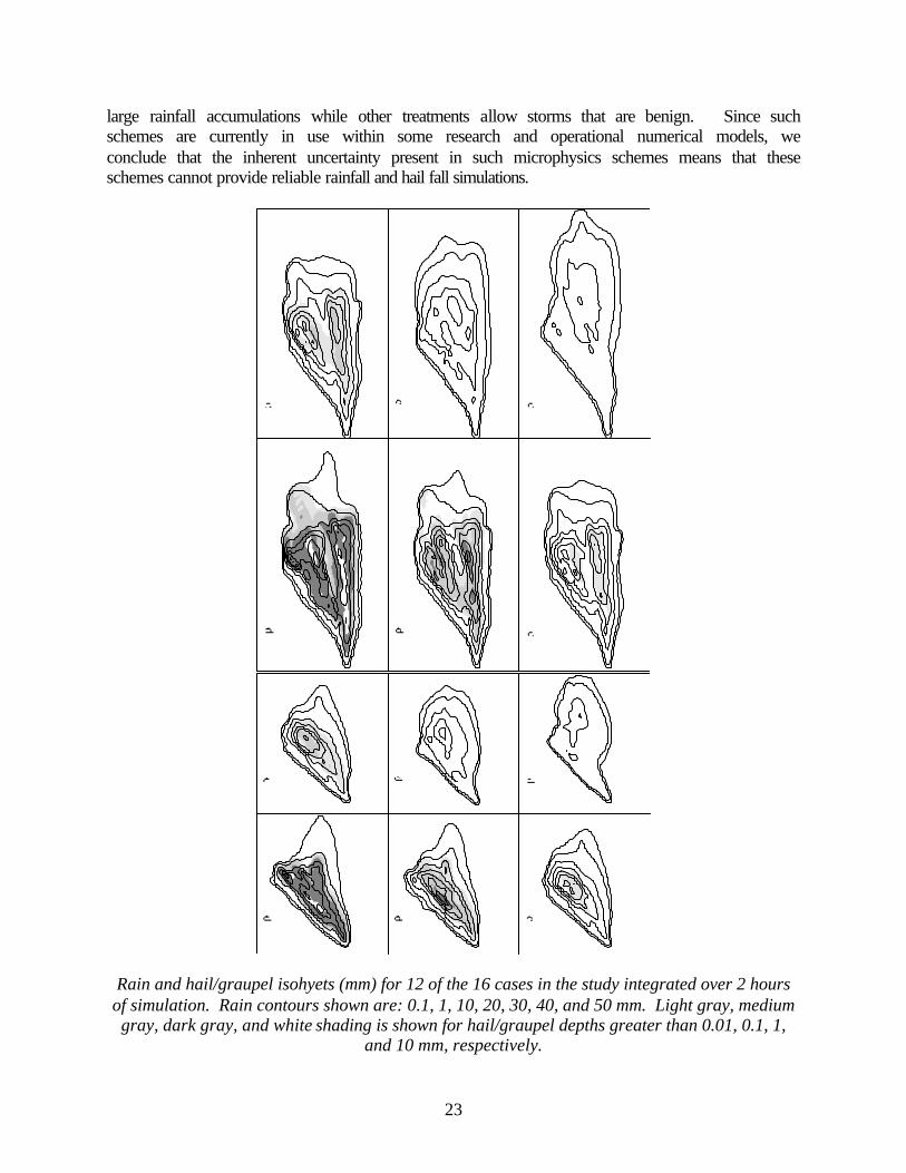
The second manuscript details the differences in thunderstorm precipitation as the parametric variables for the hail/graupel category change within their observed limits (see figure below). We use a three-class ice microphysics scheme similar to that used by others. Some microphysical treatments allow storms that drop very large and damaging hail to the ground with
23
large rainfall accumulations while other treatments allow storms that are benign. Since such schemes are currently in use within some research and operational numerical models, we conclude that the inherent uncertainty present in such microphysics schemes means that these schemes cannot provide reliable rainfall and hail fall simulations.
Rain and hail/graupel isohyets (mm) for 12 of the 16 cases in the study integrated over 2 hours of simulation. Rain contours shown are: 0.1, 1, 10, 20, 30, 40, and 50 mm. Light gray, medium gray, dark gray, and white shading is shown for hail/graupel depths greater than 0.01, 0.1, 1,
and 10 mm, respectively.
24
Project: Numerical Model Verification Studies Contributors: Baldwin, Kain
Automated data collection procedures have continued for quantitative precipitation forecasts from NCEP's operational models: an experimental version of the Eta model running twice daily, and experimental versions of the Weather Research and Forecast (WRF) model. These data are verified against analyses of both raingage observations and the so-called "Stage IV" high-resolution multi-sensor precipitation fields from NCEP using equitable threat (ET) and bias scores. These scores are compiled on a monthly basis and updated daily on the web at http://www.nssl.noaa.gov/etakf/verf/.
Development of new prototype verification techniques has also continued at CIMMS. These techniques are designed to mimic, as closely as possible, how a human subjectively assesses the skill of a forecast field or spatial maps of meteorological variables. In this work, we are expanding the paradigm of "point-to-point" verification to the verification of "events" or "objects", which are defined as meteorological phenomena. The main challenge is to develop an objective method to determine which regions within the spatial field possess similar attributes, which will likely be defined as some set of measures of the statistical structure of the spatial field. New measures of accuracy could then be obtained by examining the similarity between the forecast and observed objects.
This work is being corroborated by interactions with weather forecasters. Specifically, subjective impressions of model-forecast skill are being cross-checked against these new verification measures to determine whether or not the measures are providing useful information on the accuracy of the model for their particular needs. Project: Improving Numerical Guidance for Mesoscale Forecasting Contributors: Baldwin, Kain
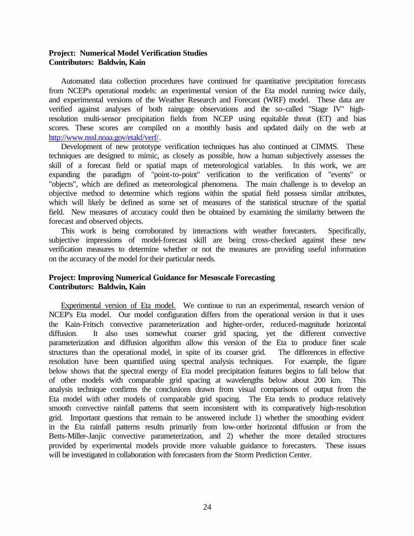
Experimental version of Eta model. We continue to run an experimental, research version of NCEP's Eta model. Our model configuration differs from the operational version in that it uses the Kain-Fritsch convective parameterization and higher-order, reduced-magnitude horizontal diffusion. It also uses somewhat coarser grid spacing, yet the different convective parameterization and diffusion algorithm allow this version of the Eta to produce finer scale structures than the operational model, in spite of its coarser grid. The differences in effective resolution have been quantified using spectral analysis techniques. For example, the figure below shows that the spectral energy of Eta model precipitation features begins to fall below that of other models with comparable grid spacing at wavelengths below about 200 km. This analysis technique confirms the conclusions drawn from visual comparisons of output from the Eta model with other models of comparable grid spacing. The Eta tends to produce relatively smooth convective rainfall patterns that seem inconsistent with its comparatively high-resolution grid. Important questions that remain to be answered include 1) whether the smoothing evident in the Eta rainfall patterns results primarily from low-order horizontal diffusion or from the Betts-Miller-Janjic convective parameterization, and 2) whether the more detailed structures provided by experimental models provide more valuable guidance to forecasters. These issues will be investigated in collaboration with forecasters from the Storm Prediction Center.
25
Fourier energy spectra for 3h accumulated precipitation from model forecasts and observed radar/gage analyses during June 2002. Spectra are ensemble averages of 37 cases of 12, 24,
and 36h forecasts plus 33 cases of 48h forecasts from each model along with observed fields at matching times.
Development of the WRF model. A semi-operational procedure for running and evaluating
the WRF model was developed. In particular, the research model forecasts were generated on a daily basis and model precipitation output was incorporated into our routine precipitation verification procedures. We collaborated with scientists at NCAR to supplement our forecasts with higher resolution WRF output from NCAR. The NCAR forecasts are also ingested into our verification database. The high-resolution forecasts were also included in organized subjective verification efforts that took place during the 2002 SPC/NSSL/CIMMS Spring Field Program. Subjective verification statistics indicate that forecasters found the value of WRF forecasts to be comparable to forecasts from the operational Eta. These results are quite encouraging considering that the WRF is still in a relatively early stage of development. Currently, WRF model development is hindered by the lack of a post-processing platform that is consistent with NCEP operational needs and accessible by scientists at various WRF development centers. CIMMS scientists are playing a leading role in developing a WRF post-processing package that will produce research-quality output similar to output currently being produced by operational NCEP models (i.e., having identical grids, computation of diagnostic quantities, etc.) This software will contribute significantly towards unifying the WRF model research occurring at different research centers.
26
Project: CAPS Contribution to the WRF Model Development Contributors: Xue, Gao, Brewster, Ren
This project contributes to the WRF model development component of a project supported by the FAA Aviation Weather Research program. The work at CAPS emphasizes the development of radar data assimilation components of the WRF three-dimensional variation (3D-VAR) data assimilation system, the validation of land surface models through comparison with soil temperature and moisture measurements from the Oklahoma Atmospheric Surface-layer Instrumentation (OASIS) project, and the initialization of a soil model through variational methods.
CAPS began the design of the radar-based component of the WRF 3D-VAR data assimilation system in 2000. Because of the spatially and temporally transient nature of flows at the non-hydrostatic flows, the application of 3D-VAR is considerably more complicated and requires the application of more sophisticated dynamical constraints. Further, Doppler radar data are a crucial source of non-conventional observations that must be properly analyzed. In 2001 and 2002, we developed a 3D-VAR framework that can handle all conventional data plus the Doppler radar radial velocity and reflectivity data (Gao et al. 2001). The system contains several equation constraints built around the three-dimensional nonhydrostatic equations of motion (Gao et al. 2002). Among the equation constraints are the three-dimensional mass continuity equation, diagnostic pressure equation, and the radial component of momentum equations. These equations are formulated in the terrain-following coordinates, as is the variational analysis. Work was also performed in the areas of radar data preprocessing and quality control.
CAPS worked on developing a variational parameter retrieval system for soil moisture and temperature, using the direct measurement data sets from Oklahoma Mesonet as the ground truth for verification. For such procedures to work well, the soil model needs to perform reasonable well. Model validation and sensitivity studies were performed, and the effort lead to an improvement to the force-restore model based on soil temperature prediction equations (Ren and Xue, 2002a, b). The impact of further improvements to the soil moisture equations is being examined. An initial version of the adjoint code of a two-layer soil model has also been developed, with the aid of an automatic adjoint code generator. Further code development is needed to couple the adjoint of the soil model and the PBL scheme to form a 4D-VAR retrieval system. Initial work with a non-adjoint based retrieval scheme is reported in Ren et al. (2002). Project: Ensemble Cloud Model Forecasting Contributor: Elmore
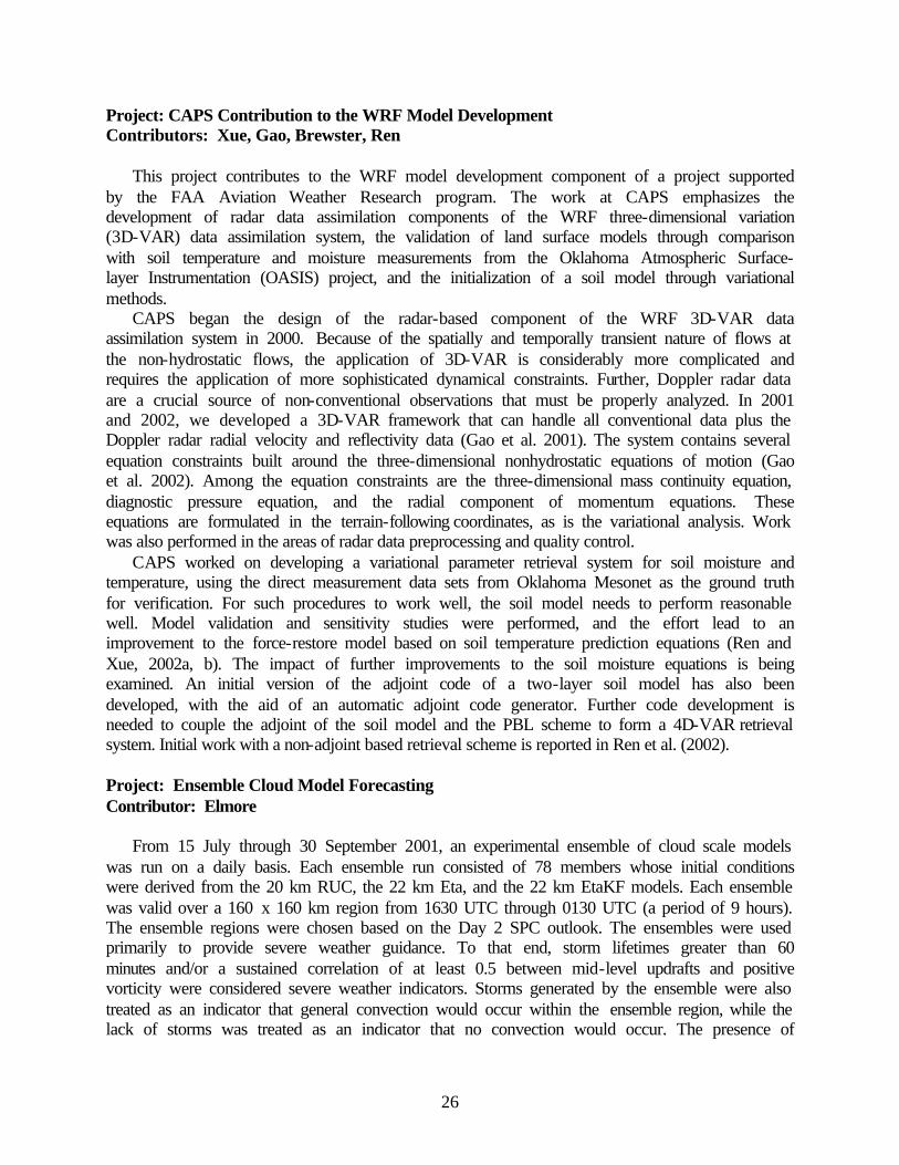
From 15 July through 30 September 2001, an experimental ensemble of cloud scale models was run on a daily basis. Each ensemble run consisted of 78 members whose initial conditions were derived from the 20 km RUC, the 22 km Eta, and the 22 km EtaKF models. Each ensemble was valid over a 160 x 160 km region from 1630 UTC through 0130 UTC (a period of 9 hours). The ensemble regions were chosen based on the Day 2 SPC outlook. The ensembles were used primarily to provide severe weather guidance. To that end, storm lifetimes greater than 60 minutes and/or a sustained correlation of at least 0.5 between mid-level updrafts and positive vorticity were considered severe weather indicators. Storms generated by the ensemble were also treated as an indicator that general convection would occur within the ensemble region, while the lack of storms was treated as an indicator that no convection would occur. The presence of
27
cloud-to-ground lightning was used as an indicator of observed convection. Manual determination of cell lifetimes is used to validate the forecast storm lifetimes.
Overall, the results are encouraging. Re-sampling techniques are used to examine the stability of the particular skill scores (see figure below). Storm lifetime is used as a proxy for severe weather. Modeled storms lasting longer than 60 minutes are used as severe weather indicators, as are storms that meet the supercell criteria.
Box-and-whisker plots of True Skill Statistic for the ensemble, based on bootstrap re-sampling.
Project: Spatial Bias Errors in Gridded Numerical Forecast Models Contributors: Elmore, Baldwin, Schultz
For a one-year period, both 0000 and 1200 UTC runs of the operational Eta model have been archived at the NSSL. The Eta analysis is used to analyze the accuracy of forecasts from previous runs. Hence, forecast errors can be determined for any of the archived fields (e.g., 24 h forecasts of 500 hPa geopotential). Using the collection of forecast error fields, the spatial distribution of 95 percent confidence intervals are constructed to show whether the mean bias errors are statistically significant (see figure below). Mean bias errors are defined for the four seasons and for the year. Some notable differences between the spatial bias error structure of the 0000 UTC forecast cycle and the 1200 UTC forecast cycle are observed. Notable differences are
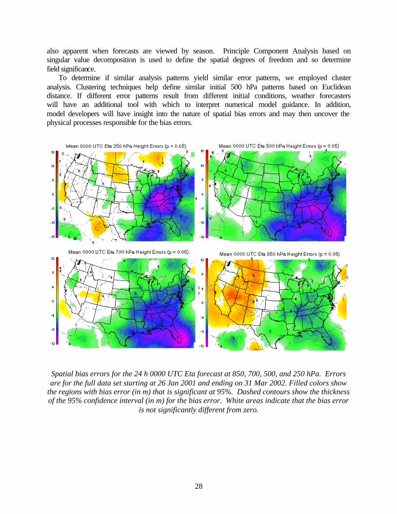
28
also apparent when forecasts are viewed by season. Principle Component Analysis based on singular value decomposition is used to define the spatial degrees of freedom and so determine field significance.
To determine if similar analysis patterns yield similar error patterns, we employed cluster analysis. Clustering techniques help define similar initial 500 hPa patterns based on Euclidean distance. If different error patterns result from different initial conditions, weather forecasters will have an additional tool with which to interpret numerical model guidance. In addition, model developers will have insight into the nature of spatial bias errors and may then uncover the physical processes responsible for the bias errors.
Spatial bias errors for the 24 h 0000 UTC Eta forecast at 850, 700, 500, and 250 hPa. Errors are for the full data set starting at 26 Jan 2001 and ending on 31 Mar 2002. Filled colors show
the regions with bias error (in m) that is significant at 95%. Dashed contours show the thickness of the 95% confidence interval (in m) for the bias error. White areas indicate that the bias error
is not significantly different from zero.
29
Project: Exploring Efficient Methodologies for Storing and Transferring Weather Data Contributor: Liang
Over the past year, CIMMS scientists at the SPC have conceived and analyzed various methods for processing very large, high-resolution data sets in time critical environments. Based on an analysis of various methodologies, we designed and tested a new data storage paradigm using a NFS server (NetApp F740) by which we were able to de-couple the compute server and the file/data server. The successful demonstration of this prototype shows that computers used for weather research can upgrade or maintain research computations with minimal impact to continuous data flow. Project: Precipitation-Type Research Contributors: Cortinas, Baldwin
During the past year, we tested various prototype algorithms that estimate the type of precipitation reaching the ground given a particular thermodynamic structure. Each algorithm was evaluated using output from a mesoscale model during the winter of 2001-2002. During the winter, the algorithms were run and analyzed each day to determine the accuracy and skill of the output. In addition to analyzing each algorithm, the algorithms were also combined to form an ensemble forecast, which was analyzed as well.
Preliminary results indicate that all the algorithms were skillful compared to a random precipitation-type forecast for all types of precipitation. Most were more skillful than the current precipitation-type algorithm, used by many operational meteorologists, for all types of precipitation except ice pellets. Project: Assimilation of Lightning Data into Mesoscale Models Contributors: Mansell, Ziegler, MacGorman, Fiedler, Beasley
The cloud-to-ground lightning assimilation methods developed for the MM5 model have be ported to the COAMPS model. Additionally, the model can also assimilate total lightning data from the lightning-mapping array. A case from the STEPS field program is being used to evaluate the impact of the assimilation. This project has ended. Plans - FY03 Project: Implementation of CIMMS Stratiform Cloud Parameterization Into a Regional
Forecast Model Contributors: Mechem, Kogan
In the coming year, this 6-year project supported by the U.S. Dept. of Defense under the Multidisciplinary University Research Initiative Program will be completed. A presentation of the research findings at scientific conferences and in journal publications will be an important part of this year effort.
30
Project: Collaborations Between the Research and Operational Forecasting Communities Contributors: Baldwin, Kain
CIMMS/NSSL scientists will continue to work closely with SPC forecasters and research scientists. Activities will include daily map discussions, individual research projects, and forecaster training activities. Project: Objective Analysis Studies Contributor: Spencer
The variational objective analysis scheme for analyzing scalar variables has been tested thus far by using analytic observations only. The next step is to compare the analysis techniques using structures that more realistically mimic atmospheric structures. Specifically, random grid points taken from model analyses will be treated as observations and analyses will be performed to determine the circumstances for which the variational method for objective analysis is superior. Also, the variational scheme will be tested in a real-time environment using actual observations and compared to the analysis scheme currently used in the operational environment. Project: Polarimetric Radar Observations of Downburst-Producing Thunderstorms Contributor: Scharfenberg
This research will be finalized and submitted to a refereed journal for publication. Observations of downburst-producing thunderstorms, including additional research into the possible operational applications of this research for weather forecasting, will be made in conjunction with the Joint Polarization Experiment (JPOLE). Project: NOAA New England Forecasting Pilot Program: High Resolution Temperature
and Air Quality Contributors: Kain, Baldwin, Yussouf
CIMMS scientists have played a major role in executing a multi-agency numerical modeling study for New England. This study is designed to quantify improvements in the forecasting of temperature and air quality in New England resulting from new and augmented observations and numerical modeling over the region. Furthermore, the study will assess the benefits of better predictive capabilities to the energy sector and provide a pathway for the high-resolution forecasts to be implemented operationally.
CIMMS scientists are generating model forecasts from different configurations of the Eta the Penn State/NCAR (MM5) mesoscale research models to contribute as members of a multi-model ensemble for this study. In addition, they are collaborating with scientists at NCEP and FSL to coordinate the collection of model output, preparing the full ensemble, and producing and displaying ensemble forecasts on the World Wide Web for future analysis.

31
Project: Warning Decision Making Analysis Contributors: Magsig, Wood, Yu, Hoggard, Said
Warning decision-making analysis is planned to continue during the next plan year for both severe convective weather and winter weather. One of the areas of analysis will focus on WDTB workshops dealing with warning methodologies. From the collaboration in these workshops, refinement of multi-sensor warning methodologies are planned as they relate to tornadoes, hail, wind, flash flooding, and winter weather. We will conduct research on how to best utilize mesoscale model guidance in the warning decision making process, which will also be a continuing component of warning decision making analysis. Project: Warning-Related Forecast Improvements Contributors: Magsig, Wood, Yu, Hoggard, Said
Ongoing warning-related forecast improvements are planned to continue during the next year. More time will be spent using high-resolution radar data (such as the Doppler On Wheels) to document the structure and evolution of tornadic storms and illustrate sampling limitations of some radars. Data integration into warning decision-making will also continue to be an area of active research. Determining optimal ways to incorporate mesoscale model guidance into warning decision making for severe deep convection and winter weather are planned along with improvements to mesoscale analysis techniques. Project: Warning Simulation Contributors: Magsig, Wood, Yu, Hoggard, Said
The recent innovation of using simulations in warning decision-making will continue to be an area of active research. Developing better techniques for feedback and evaluation will be a focus for improving the effectiveness of simulations. The simulation framework developed for severe convective weather will be further applied to flash flood warning decision making and winter weather decision making, where the human's data assimilation process can be quite different from that for severe hail, wind, and tornado warning decision making. Project: Multiple-Radar Severe Storm Analysis Program (MR-SSAP) Contributors: Stumpf, Smith, Manross, Thomas, McCoy
In the next year, CIMMS will enhance the MR-SSAP algorithms and complete the development of the multiple-radar MDA, TDA, and DDPDA algorithms. These will be used to evaluate Doppler radar data for severe storms in the southeast United States. Project: Quantitative Precipitation Estimation and Segregation Using Multiple Sensors
(QPE SUMS) Contributors: Gourley, Zhang
Throughout the next year, the QPE SUMS rainfall products will be compared to the Office of Hydrology's Multisensor Precipitation Estimation algorithm over the Tar River in North Carolina to determine which analysis system is more accurate. A new convective precipitation estimation
32
procedure will be developed and tested, as well as a velocity dealiasing module for evaluating data in polar coordinates. Lastly, a script will be written for automated archiving of QPE SUMS products for other research projects. Project: Three-Dimensional Multiple Radar Reflectivity Mosaic Contributors: Zhang, Xia, Calvert, Langston, Gourley
Over the next year, this project will continue to develop many severe storm algorithms in order to analyze severe storm structure. In addition to radar data, many of these algorithms will make use of other data types, such as satellite data, model data, and weather observations. Work will also begin on developing research algorithms to analysis velocity data. Project: Arizona Summertime Radar Climatology Contributors: Heinselman, Schultz
This work will continue by extending the data set to include the 1997 summer season. Radar reflectivity mosaics using data from radars at Phoenix and Flagstaff will be used to identify diurnal reflectivity regimes. Morning and evening soundings at Phoenix will be examined to identify any sounding characteristics unique to each reflectivity regime. Surface data will be examined to identify surges of moisture from the Gulf of California; identified surges will be related to reflectivity regime to determine their relative contribution toward convective activity in Arizona. Finally, upper-air maps and satellite data will be examined to identify the variety of flow patterns associated with identified reflectivity regimes.
Following the completion of this observational study, a mesoscale model (MM5) will be used to study the sensitivity of the model's diurnal precipitation output to composite soundings associated with each observationally identified regime. Such modeling studies are important because current operational models are severely limited in their ability to forecast diurnal precipitation patterns. Project: Microphysical Modeling Studies Contributors: Gilmore, Rasmussen
We are now studying the differences in the microphysics between our simple three-class ice scheme and those available in another research numerical model. Project: Numerical Model Verification Studies Contributors: Baldwin, Kain
Computation of ET and bias scores for various operational and experimental prediction models (including Eta and WRF) will continue. These scores will be computed in an automated fashion for the verification of quantitative precipitation amounts, and will be utilized for comparison with the subjective impressions of weather forecasters. In addition, development and testing of new "object-oriented" verification techniques will continue.
33
Project: CAPS Contribution to the WRF Model Development Contributors: Xue, Gao, Brewster, Ren
We will work on incorporating our radar assimilation components into the WRF 3D-VAR framework. We will investigate several strategies for 3D-VAR using radar data ranging from conventional techniques, to a multi-scale, multi-step process in which conventional 3D-VAR is followed by other variational procedures that insert correct storm-scale information into the domain and remove incorrect information in the background fields subject to appropriate dynamical constraints. The dynamic equations constraints built into the 3D-VAR system will be further refined and evaluated. WSR-88D base (Level 2) data from multiple systems ingested via the Collaborative Radar Acquisition Field Test (CRAFT) project will be included in these tests.
We will also continue to work on the problem of soil model initialization and calibration. Further development is needed to include the adjoint of the planetary boundary layer parameterization in order to be able to perform soil state-variable retrieval as a coupled system. Work continues in applying a non-adjoint parameter retrieval method for the soil model. We will also perform additional soil model sensitivity experiments. An adjoint code is being developed for a relatively simple two-layer soil model. If this proves effective, adjoint code will also be developed for and the variational procedure applied to the best land surface model option in the WRF model. Project: NOAA New England Forecasting Pilot Program: High Resolution Temperature
and Air Quality Contributors: Kain, Baldwin, Yussouf
Ensemble data will be analyzed extensively. Subject to availability of funds for the coming year, a second intensive modeling study will be carried out. This study will build on the knowledge gained in the initial pilot program and utilize various assimilation techniques to include augmented observations over the New England region. Project: Ensemble Cloud Model Forecasting Contributor: Elmore
Adaptive storm motion will be added, such that the modeled storm always stays within the grid. In addition, a horizontally and vertically stretched grid will be used, so that the model domain can be enlarged without a significant additional computational cost. Finally, three mesoscale models will again be used, but with 117 members. Done this way, forecasters can eliminate members that originate from mesoscale forecasts that are deemed unreasonable or unlikely. This effectively allows for some field modification of the ensemble initial conditions. Project: Spatial Bias Errors in Gridded Numerical Forecast Models Contributors: Elmore, Baldwin, Schultz
Additional data will be analyzed from the EtaKF research model to help determine the nature of the spatial bias errors. The differences between the Operational Eta and the EtaKF will be used to help determine some of the physical processes that might be responsible for the different spatial bias error patterns that appear in each model.
34
Project: Exploring Efficient Methodologies for Storing and Transferring Weather Data Contributor: Liang
Research will continue to improve methodologies for storing, transferring, and processing large, high-resolution meteorological datasets given the ever-increasing data size and network bandwidth in today's research environments. We expect to incorporate new computing and network equipment, such as the new second generation Intel IA-64 CPUs, AMD 64-bit x86 Opteron CPUs systems, and high-speed network switches, into the current methodologies. Project: Precipitation-Type Research Contributors: Cortinas, Baldwin
Research will continue on determining the accuracy of a suite of prototype precipitation-type algorithms to improve precipitation-type forecasts. Various experimental ensemble techniques will be analyzed during the next year to identify the most accurate and most skillful methods of combining output from various types of algorithms. Project: Land Atmosphere Memory Quantified Using Observations from the Oklahoma
Mesonet and the NOAA Land Surface Model Contributors: Basara, Nemunaitis, Monroe
An initial analysis has been conducted to identify those sites and dates that are suitable for use in the research project. The following work will be pursued: (1) development of a quality controlled data set that involves meteorological and hydrologic observations from Oklahoma Mesonet sites, thereby obtaining new insights into land-atmosphere interactions from diagnostic studies using such data; (2) quantify the impact of observed variability in soil hydraulic properties within the NOAA Land Surface Model (LSM) and explore the utility of ensemble techniques in the LSM in forecasting atmospheric processes within the planetary boundary layer; and (3) identify the parameterizations in the LSM that are sensitive to land surface conditions; using Mesonet data, the parameterizations will be modified, improved, and tested to produce reduced model variability. 3. Climatic Effects of/Controls on Mesoscale Processes Progress – FY02 Project: Fourth Workshop on Regional Climate Prediction and Applications – Tropical
Pacific Islands and Rim (27 May-5 July 2002) Contributor: Lamb
This Workshop was the fourth in a series being staged by CIMMS, with the primary financial sponsorship of the International Activities Office of the U. S. National Weather Service, and additional support from NOAA’s Office of Global Programs (OGP), USAID’s Office of Foreign Disaster Assistance (OFDA), and the Climate Information and Prediction Service (CLIPS) of the
35
World Meteorological Organization (WMO). The Workshop series is intended to improve the capabilities of national meteorological and hydrological services (NMHSs) in developing nations in the following respects – to understand the behavior of the global climate system; to use such understanding to develop or adapt seasonal climate (especially rainfall) prediction schemes for their countries; and to work with other professionals in their countries to apply the prediction schemes in the management of agricultural production, water resources, energy generation and consumption, and public health. The need for these Workshops emerged from NMS leaders of many developing nations recognizing that their organizations did not possess the expertise to capitalize on the seasonal prediction and application opportunities offered by the 1997-98 El Niño. This need was emphasized further by current predictions that another El Niño will develop in mid-to-late 2002.
This Fourth Workshop capitalized on the expertise of the CIMMS leadership and several of its long-time colleagues by focusing on the role of Tropical Pacific Ocean for climate in and immediately around that basin. Workshop participants (20) came from nations whose regional climate (especially rainfall) variability is influenced by the tropical Pacific on seasonal-to-interannual time-scales. Those nations extend from Southeast Asia (China, Hong Kong-China, Cambodia, Thailand, Malaysia) across the Philippines and Papua New Guinea to the islands of the western Pacific (Micronesia, Vanuatu, Fiji, Samoa), and also lie along the western coast of Central and South America (Mexico, Colombia, Peru, Bolivia, Chile). Thus, the participants came from WMO Regions II (Asia), III (South America), and V (South-West Pacific).
Most of the instruction was provided by Professor Lamb, Dr. José Marengo (native of Peru; now at Centro de Previsão de Tempo e Estudos Climaticos, CPTEC, Instituto Nacional de Pesquisas Espacias, Brasil), and Dr. Neville Nicholls (Bureau of Meteorology Research Centre, Australia). Their Teaching Assistants were Mr. Issa Lele (Nigerien Direction de la Météorologie Nationale, and African Centre of Meteorological Applications for Development, Niamey, Niger) and Mr. Helio Camargo Junior (CPTEC, Brasil). In addition, guest lectures were given by Dr. Elbert W. (Joe) Friday, Jr. (U.S. National Research Council; formerly Permanent Representative of USA with WMO), Dr. Patricio Aceituno (University of Chile), Dr. M. James Salinger (National Institute for Water and Atmospheric Research, NIWA, New Zealand), and Professor Lance M. Leslie (University of Oklahoma). The Workshop Program followed that described in an article on the Workshop Series in the April 2002 issue of the WMO Bulletin. Project: African Centre of Meteorological Applications for Development Contributor: Lamb, Dibi, El Hamly, Segele
A high level of collaboration and cooperation continued between CIMMS and the African Centre of Meteorological Applications for Development (ACMAD, Niamey, Niger) during the fiscal year. These activities are funded by an ongoing grant from the International Activities Office of the U.S. National Weather Service. Interactions included the following – continuation of a 5-year project entitled "New Radio and Internet Technology for Communication of Weather and Climate Information to Rural Communities for Sustainable Development in Africa" (RANET), that is funded by the U.S. Agency for International Development; and continued full-time research at CIMMS on aspects of African climate variability and predictability (for OU M.S. and Ph.D. degrees) by Ms. Pauline Agoh Dibi (Ivory Coast), Mr. Mostafa El Hamly (Morocco), and Mr. Zewdu Tessema Segele (Ethiopia).
36
Project: North Atlantic Climate Variability of Different Timescales Contributors: Portis, El Hamly, Lamb
We have investigated the seasonal/monthly signal of the NAO, the dominant mode of atmospheric variability over the North Atlantic, over different timescales with a focus on identifying coherent behavior across calendar months (see figure below). These coherences might indicate seasonal coordination between the atmosphere and the boundary forcing of the ocean/cryosphere. Seasonal coordination has recently been proposed as a feedback mechanism to enable coupling between the high-frequency atmosphere and the other low-frequency components of the North Atlantic climate system. If there exist coordination, then this would enhance the predictability of the NAO and its influential impact on the regional climate. A journal article on this work, “Timescale behavior of the seasonal signal of the North Atlantic Oscillation”, is in the final stages of preparation.
To address the seasonal aspects of the NAO signal, the above work’s results are based on a new mobile NAO index that better captures its seasonality by following the seasonal migration of the centers of action (Portis et al. 2001). Results include documentation of the strength of the monthly NAO signal and persistence across consecutive months over interannual, decadal and interdecadal timescales. The paper also investigates the existence of an internal seasonal oscillation that would allow for long-range seasonal predictability. The temporal variability or non-stationary of the NAO signal is also explored through wavelet analysis.
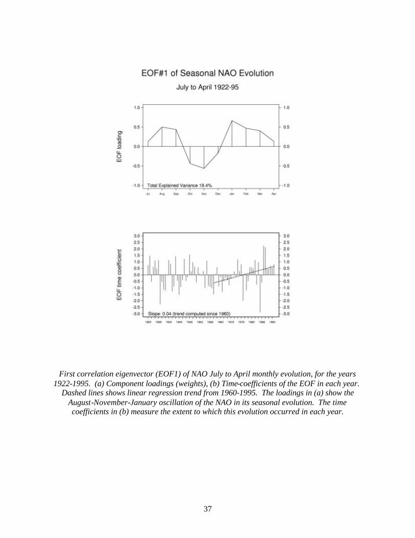
37
First correlation eigenvector (EOF1) of NAO July to April monthly evolution, for the years
1922-1995. (a) Component loadings (weights), (b) Time-coefficients of the EOF in each year. Dashed lines shows linear regression trend from 1960-1995. The loadings in (a) show the
August-November-January oscillation of the NAO in its seasonal evolution. The time coefficients in (b) measure the extent to which this evolution occurred in each year.
38
Project: North Atlantic Winter Surface Storm Track Variability Contributors: El Hamly, Lamb, Portis
We have built upon our past research on the North Atlantic winter (October-March) surface storm track variability for 1948-99 by investigating the several research areas: (1) climatological aspects of North Atlantic winter cyclone characteristics and behavior (including development and decay); (2) cyclone behavior under extreme North Atlantic Oscillation events; (3) storm track variability in the context of the recent atmospheric circulation trends; (4) ocean-atmosphere interactions over the North Atlantic Basin on decadal time-scales; (5) wavelet analysis of the North Atlantic winter storm tracks using cutting-edge wavelet techniques; (6) ENSO impact on cyclone tracks; and (7) relation of Atlantic weather systems and Moroccan precipitation patterns to NAO. The construction of a hybrid space- and time-smoothed cyclone track density function (CDF; see figure below) – which involves enhancement of an existing automated algorithm for identifying and tracking surface cyclones, an objective analysis scheme, and the Bessel technique – provides the foundation for this and future research.
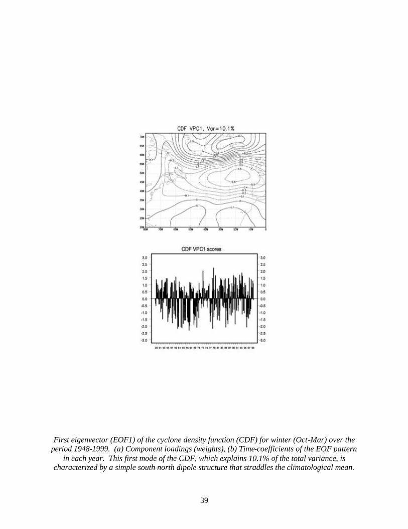
39
First eigenvector (EOF1) of the cyclone density function (CDF) for winter (Oct-Mar) over the
period 1948-1999. (a) Component loadings (weights), (b) Time-coefficients of the EOF pattern in each year. This first mode of the CDF, which explains 10.1% of the total variance, is
characterized by a simple south-north dipole structure that straddles the climatological mean.
40
Project: Variability of the North Atlantic Oscillation Contributors: Lamb, Portis, El Hamly
The Atlantic-North Africa climate system is an important theme for the international Climate Variability and Predictability (CLIVAR) program. The role of the Atlantic sea surface temperature (SST) field or ENSO event within this climate system is of high interest and debate. Two central issues that we have focused on this past year is 1) the character of the large-scale response of the atmosphere (via NAO) to the SST field on different timescales; 2) the coupling of the storm track to the atmosphere/ocean on different timescales.
Many researchers have associated a tripole pattern in the North Atlantic SST field with the North Atlantic Oscillation (Rodwell et al. 1999; Sutton and Allen 1997). A positive NAO is linked to cold SST anomalies south and west of Greenland, warm SST anomalies centered along the southeast coast of the United States and cold SST stretching westward in the subtropics. The temporal evolution of this tripole has been associated with the phases of the NAO (Sutton and Allen 1997) with a time frame of 12-14 years. Our correlation of the major patterns of variability of the storm track, NAO and SST fields all reflect coordination among these components of the climate system within this 12-14 year time frame. The storm tracks were identified from a daily cyclone density field from 20°N - 70°N and 80°W to 0° that was computed using Serreze’s cyclone tracking algorithm (Serreze et al. 1997).
Using a mobile NAO index that captures the seasonal migration of its nodes, we also studied the NAO signal on different timescales. Months with significant signal in the low frequency NAO spectrum had nodal locations over active ocean dynamics (July) and over a region with demonstrated links to low-frequency variations in the SST field (November and February). A century-scale oscillation was discovered in our study for the wintertime NAO. The phase transition years in the 1920s and the 1970s of this century-scale oscillation were accompanied by simultaneous and dramatic changes in other parts of the climate system such as the SST (Deser and Blackmon 1993). On the much shorter interannual timescale, wavelet analysis of the NAO signal showed that monthly singularities coincided with El Niño events at a rate that was statistically different from chance. Project: Characteristics of the Kiremt (June-September) Rainy Season in Ethiopia:
Variability of Kiremt Onset, Dry Spells, and Cessation Contributors: Segele, Lamb
The interannual variability of onset, dry spells, and cessation of the Kiremt rainy season was studied in association with local upper air sounding and global sea surface temperature data. The study shows that there is more variability in the onset of the Kiremt rains than in the cessation, and the highest variability is in regions where the rains start early in the year. Prior to onset, low level westerlies build up for at least two pentads, while upper level strong easterlies exceeding 10 ms-1 develop at least 3 pentads before the onset of the season over central Ethiopia. Lower tropospheric cooling, upper tropospheric and lower stratospheric warming, and tropospheric moisture increase are the major seasonal changes that accompany the onset of the season. These changes reverse sign after the rain ceases.
Dry spells are more frequent during the last one-third of the Kiremt, during which time the tropical easterly jet (TEJ) and the surface westerlies become more infrequent or weak. During years when long dry spells occur, easterly winds prevail throughout the troposphere and the TEJ
41
becomes weak, while in years when dry spells are short, westerlies prevail at lower levels and the TEJ becomes strong.
The onset and the effective length of the Kiremt growing season strongly correlate with Pacific sea surface temperature (SST). In particular, El Niño events are associated with delayed onset and shorter effective growing length. On the other hand, the cessation of the Kiremt more strongly correlates with SST over the Arabian Sea and Indian Ocean than over the Pacific Ocean. Project: Investigation Of Temporal And Spatial Variations Of Broadband Surface Albedo
Across The ARM Southern Great Plains Site Contributors: Duchon, Hamm
This project has focused on using solar broadband (0.3 to 3.0 micrometers) irradiance data from ARM Program SIRS (Solar Infrared Radiation Station) to compute ground-based surface albedos at six ARM Program extended facilities within the SGP region. The six locations were selected based on their high degree of surface representativeness with respect to the surrounding area. During the past year, software was developed to calculate daily values of hemispherical broadband surface albedo using 1998 and 1999 SIRS measurements from the six sites. Each daily albedo value represents the ratio of the total reflected shortwave irradiance to the total downwelling shortwave irradiance for one daylight cycle at a given location. These daily albedos have been arranged into annual time series for climatological analysis. Time series of satellite-derived Normalized Difference Vegetation Index (NDVI) and ground-measured daily precipitation have also been constructed to help determine if seasonal cycles of daily albedo exist and whether precipitation-related factors such as surface wetness can be linked to surface albedo.
The main results of this research are: 1) the maximum difference between mean albedos over the two-year period among the six sites is at least three times the difference in annual means at any site; i.e., the spatial variation is at least three times the interannual variation among the six sites; 2) there is little relation between mean annual albedo and annual precipitation; and 3) for sites with large amounts of bare soil, there are systematic changes in daily albedo in response to rainfall events followed by clear dry periods. Project: ARM Program Southern Great Plains Site Scientist Contributors: Lamb, Bahrmann, Bond
Since April 1992, CIMMS has played the role of “Site Scientist” for the Southern Great Plains ARM Site. This involves (1) provision of scientific guidance for site operations, (2) conducting a substantial research program that uses observations from the site and feeds back to enhance the effectiveness of the site, and (3) providing educational outreach across the K-12 levels to approximately 200 schools in Oklahoma and south-central Kansas. The Oklahoma Climatological Survey performs the educational outreach component.
ARM SGP Site Scientist Team activity also includes participation in Intensive Observational Periods (IOPs) conducted at or near the Central Facility site. One member of the site scientist team worked at the Central Facility this past year, providing SGP Site Operations personnel with scientific support for the operation of the site. This scientist also participated in field site inspection visits as part of the Continuous Quality Improvement Program (CQIP) and serves as the soil moisture instrument mentor.
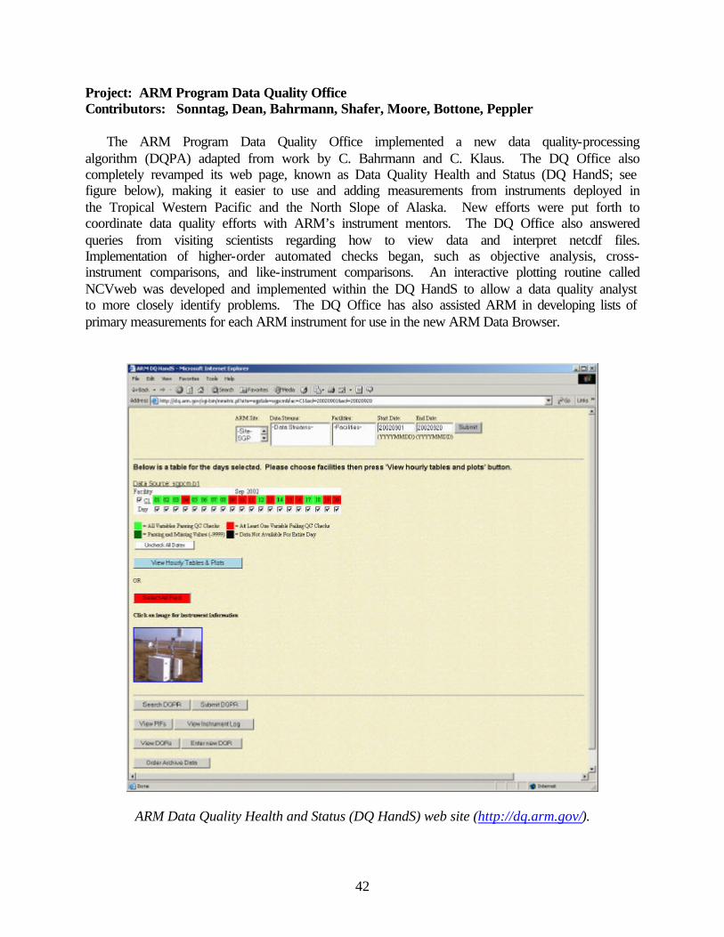
42
Project: ARM Program Data Quality Office Contributors: Sonntag, Dean, Bahrmann, Shafer, Moore, Bottone, Peppler
The ARM Program Data Quality Office implemented a new data quality-processing algorithm (DQPA) adapted from work by C. Bahrmann and C. Klaus. The DQ Office also completely revamped its web page, known as Data Quality Health and Status (DQ HandS; see figure below), making it easier to use and adding measurements from instruments deployed in the Tropical Western Pacific and the North Slope of Alaska. New efforts were put forth to coordinate data quality efforts with ARM’s instrument mentors. The DQ Office also answered queries from visiting scientists regarding how to view data and interpret netcdf files. Implementation of higher-order automated checks began, such as objective analysis, cross-instrument comparisons, and like-instrument comparisons. An interactive plotting routine called NCVweb was developed and implemented within the DQ HandS to allow a data quality analyst to more closely identify problems. The DQ Office has also assisted ARM in developing lists of primary measurements for each ARM instrument for use in the new ARM Data Browser.
ARM Data Quality Health and Status (DQ HandS) web site (http://dq.arm.gov/).
43
Project: Program Support through the Assimilation, Analysis and Dissemination of Global Raingauge Data
Contributors: Morrissey, Postawko, Greene
The Surface Reference Data Center (SRDC), which is a sub-program of the Global Precipitation Climatology Project (GPCP), has been funded by the Climate Observation program for several years. This quasi-operational, quasi-research center produces surface precipitation products from raingauge networks of sufficient density worldwide to be useful for comparisons with satellite rainfall estimates. The products are placed on the Internet (http://srdc.evac.ou.edu) for easy download by the research community. In addition, the SRDC developed new statistical methodologies through research to facilitate these comparisons. The SRDC is housed at the Environmental Verification and Analysis Center (EVAC) at OU.
Other work this year included an analysis of the GPCP’s satellite-only product using the Pacific island raingauge data (i.e., the PACRAIN database). The PACRAIN database was also updated through 2002.
Work was completed on assessing the usefulness of NASA’s Tropical Rainfall Measuring Mission’s (TRMM) validation data sets for possible inclusion into the SRDC and validation products. Results using Florida gauges appear useful for validation purposes.
Taylor’s Atlas, which contains monthly gauge totals from many Pacific islands prior to 1970, has been digitized and posted on our web page and is available for downloading.
The Schools of the Pacific Raingauge Climate Experiment (SPaRCE), funded initially by NOAA, has over 200 schools across the Pacific equipped with a direct read raingauge. Each school takes daily raingauge measurements and these measurements are then provided to the research community (http://www.evac.ou.edu/sparce/). In return for taking raingauge measurements, the schools are supplied with equipment and educational materials. Plans – FY03 Project: Fourth Workshop on Regional Climate Prediction and Applications – Tropical
Pacific Islands and Rim (27 May-5 July 2002) Contributor: Lamb
A fifth workshop is planned for spring 2003. Project: North Atlantic Climate Variability of Different Timescales Contributors: Portis, El Hamly, Lamb
To further explore the hypothesis that seasonality provides a feedback mechanism for coupling between the atmosphere and the other components of the North Atlantic climate system, the seasonal signal of the boundary forcing should also be studied. This would be an interdisciplinary approach involving such topics as Arctic radiation budget due to changes in sea ice extent and SST anomalies from ocean currents and salinity changes of waters over oceanic gyres due to in-situ variability of the hydrological budget or advection of sea ice. Our previous work has shown July and March to have unique seasonal NAO signals. We would like to explore the evolution of the boundary forcing for these two months.
44
Project: North Atlantic Winter Surface Storm Track Variability Contributors: El Hamly, Lamb, Portis
The main future task of this work is to bring to finish all project components, along with a low-frequency NAO simulation of 21st century climate changes (under the aforementioned A2 and B2 forcing scenarios) using global coupled ocean-atmosphere general climate models. M. El Hamly will use the research on winter surface cyclone track variability over the North Atlantic Basin for his doctoral thesis. Project: Investigation Of Temporal And Spatial Variations Of Broadband Surface Albedo
Across The ARM Southern Great Plains Site Contributors: Duchon, Hamm
Nearly 3 additional years (2000-2002) of solar radiation data have been collected at SIRS sites. Thus, it is appropriate to analyze these data using current techniques to obtain more meaningful albedo climatology. Based on a preliminary investigation of data from the NOAA-14 AVHRR (Advanced Very High Resolution Radiometer) to estimate surface albedo, it was determined that a relatively sophisticated radiative transfer model was necessary to achieve useful results. Applying an appropriate model to "top of the atmosphere" reflectance data to convert them to broadband surface albedo represents our next research step. Project: ARM Program Southern Great Plains Site Scientist Contributors: Lamb, Bahrmann, Bond
The Site Scientist Program will continue at least for another two years, with all present tasks associated with the activity continuing. Also, instrument-mentoring activities will continue for the soil moisture system. Mentors are charged with deploying, maintaining, and improving instrument systems, and assuring the quality of the data from them. Project: ARM Program Data Quality Office Contributors: Sonntag, Dean, Bahrmann, Shafer, Moore, Bottone, Peppler
The ARM Program Data Quality Office is spearheading an effort to better organize the reporting of data quality results to better inform (1) site operators to help minimize the amount of undesirable data collected and (2) data users so that they may make informed decisions when manipulating ARM data. This reporting mechanism has been called the Data Quality Reporter, to be operational by April 2003, and will involve collaboration with developers at Brookhaven National Laboratory. The DQ Office will also contribute to an effort to improve access to ARM data through the development of the ARM Data Browser, collaborating with developers at Oak Ridge National Laboratory. The DQ Office has a number of goals for the coming year and beyond. These include (1) developing longer-term views of data quality by developing tools to better assess issues such as calibration drift; (2) improving automated quality control by performing a comprehensive assessment of current algorithms and augmenting them when necessary; (3) incorporating relevant ARM value added product output into DQ HandS since it provides much information about the quality of the input data streams; and (4) providing 100 percent reporting on data quality to the ARM Program for all ARM instruments.
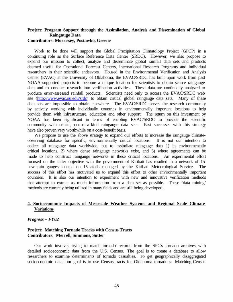
45
Project: Program Support through the Assimilation, Analysis and Dissemination of Global Raingauge Data
Contributors: Morrissey, Postawko, Greene
Work to be done will support the Global Precipitation Climatology Project (GPCP) in a continuing role as the Surface Reference Data Center (SRDC). However, we also propose to expand our mission to collect, analyze and disseminate global rainfall data sets and products deemed useful for Operational Forecast Centers, International Research Programs and individual researchers in their scientific endeavors. Housed in the Environmental Verification and Analysis Center (EVAC) at the University of Oklahoma, the EVAC/SRDC has built upon work from past NOAA-supported projects to become a unique location for scientists to obtain scarce raingauge data and to conduct research into verification activities. These data are continually analyzed to produce error-assessed rainfall products. Scientists need only to access the EVAC/SRDC web site (http://www.evac.ou.edu/srdc) to obtain critical global raingauge data sets. Many of these data sets are impossible to obtain elsewhere. The EVAC/SRDC serves the research community by actively working with individually countries in environmentally important locations to help provide them with infrastructure, education and other support. The return on this investment by NOAA has been significant in terms of enabling EVAC/SRDC to provide the scientific community with critical, one-of-a-kind raingauge data sets. Past successes with this strategy have also proven very worthwhile on a cost-benefit basis.
We propose to use the above strategy to expand our efforts to increase the raingauge climate-observing database for specific, environmentally critical locations. It is not our intention to collect all raingauge data worldwide, but to assimilate raingauge data 1) in environmentally critical locations, 2) where dense raingauge networks exist, and 3) where agreements can be made to help construct raingauge networks in these critical locations. An experimental effort focused on the latter objective with the government of Kiribati has resulted in a network of 15 new rain gauges located on 15 atolls managed by the Kiribati Meteorological Service. The success of this effort has motivated us to expand this effort to other environmentally important countries. It is also our intention to experiment with new and innovative verification methods that attempt to extract as much information from a data set as possible. These ‘data mining’ methods are currently being utilized in many fields and are still being developed. 4. Socioeconomic Impacts of Mesoscale Weather Systems and Regional Scale Climate
Variations Progress – FY02 Project: Matching Tornado Tracks with Census Tracts Contributors: Merrell, Simmons, Sutter
Our work involves trying to match tornado records from the SPC's tornado archives with detailed socioeconomic data from the U.S. Census. The goal is to create a database to allow researchers to examine determinants of tornado casualties. To get geographically disaggregated socioeconomic data, our goal is to use Census tracts for Oklahoma tornadoes. Matching Census
46
tracts with storm paths can be done using GIS and the latitude and longitude coordinates of the beginning and end of the tornado path.
All Oklahoma tornadoes between 1980 and 1999 have been matched with Census tracts from the 1990 Census. [Census tracts are designed to have approximately 5,000-8,000 persons, and so are changed from one Census to the next.] The work was done at the California Census Regional Data Center at UCLA. The Census tract identifying code(s) has been added to each tornado, and this data set will be in the public domain, allowing researchers to combine Census data with storm records. At this point in time we are waiting for the file to be cleared by the California Census Center for release. A hiring freeze has delayed the clearance of the data for release, but there is no proprietary information in the data set, so approval should be obtained shortly. Plans – FY03 Project: Matching Tornado Tracks with Census Tracts Contributors: Merrell, Simmons, Sutter
When the data set is cleared for release to us by the Census Center, we will add the file with the Census tract identifying codes to the storm records available at the SPC. Any researcher will be able to use the codes to add economic data to the tornado data set for their own research.
We will also add Census tract level economic and demographic data to a model of tornado casualties we have currently estimated using county level data. Since population density, for instance, varies tremendously across counties, this should allow considerable improvement in the precision of casualty estimates. We are currently using the tornado casualty models to estimate the cost effectiveness of tornado shelters, but improved casualty models can be used for other purposes, such as estimating the impact of improved tornado warnings. 5. Doppler Weather Radar Research and Development Progress – FY02 Project: High Resolution Radar Analysis for Aviation Weather Hazard Characterization Contributors: Brewster, Gao, Shapiro, Kemp, Thomas, Robinson, Said
A real-time demonstration for assimilation of radar data in the ARPS Data Analysis System (ADAS) and ARPS was set up for a domain overlapping the western portion of the FAA’s Corridor Integrated Weather System (CIWS) region (in the Chicago to New York corridor). Grid spacing was 3-km in the horizontal. ARPSControl software for automated processing of the data and producing web graphics (see figure below) was modified for an assimilation of ADAS analysis increments in a ten-minute window using incremental analysis updating. Diagnostic variables for icing and turbulence were added to the display software. CRAFT Level-II radar data or NIDS Level-III data were used in the cloud analysis.
The system was run in real-time for a trial in late March into April 2002. Problems were noted in the assimilation system as it produced erroneously large modeled reflectivities after the 10-minute assimilation period. Examination of the model fields revealed that an overproduction of the graupel/hail species was being caused by an unintended double counting of rain and cloud
47
species in the cloud analysis. The analysis has since been adjusted to account for this, by limiting the amount of cloud water in the presence of precipitation hydrometeors from radar. This successfully reduced the hail growth spike that had been observed. There were some hardware setbacks during this period due to recurrent disk problems that have since been addressed with a new controller. The disk problem hampered data archival, but three cases were saved for later study.
Software development continued for ingests of radar data in the ARPS 3D-VAR system and an adaptation of Shapiro’s 4-D variational wind retrieval package for CRAFT real-time datasets.
Sample web graphic from trial period showing east-west cross section of icing potential and ARPS model turbulent kinetic energy after 10 minutes of assimilation.
Project: Radar Research at the Radar Operations Center Contributor: Ray
The primary activities during the past year focused on designing and evaluating remote access programs to ensure that new Open System Remote Product Generator (ORPG) equipment being fielded to NEXRAD radar sites worldwide is optimized immediately. During the scientific testing phase, process and procedures were suggested that would allow ROC meteorologists and technicians to remotely access the ORPG in the field. These programs can be used to make routine updates for field operators and technicians, and at times can allow
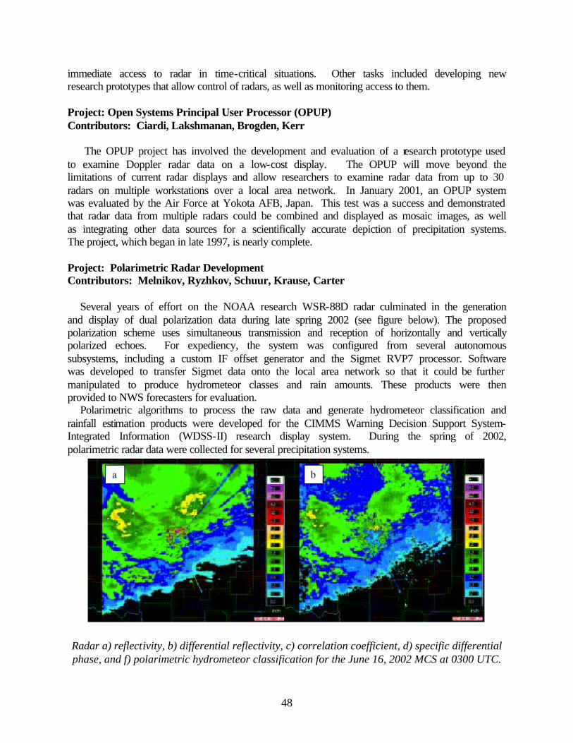
48
immediate access to radar in time-critical situations. Other tasks included developing new research prototypes that allow control of radars, as well as monitoring access to them. Project: Open Systems Principal User Processor (OPUP) Contributors: Ciardi, Lakshmanan, Brogden, Kerr
The OPUP project has involved the development and evaluation of a research prototype used to examine Doppler radar data on a low-cost display. The OPUP will move beyond the limitations of current radar displays and allow researchers to examine radar data from up to 30 radars on multiple workstations over a local area network. In January 2001, an OPUP system was evaluated by the Air Force at Yokota AFB, Japan. This test was a success and demonstrated that radar data from multiple radars could be combined and displayed as mosaic images, as well as integrating other data sources for a scientifically accurate depiction of precipitation systems. The project, which began in late 1997, is nearly complete. Project: Polarimetric Radar Development Contributors: Melnikov, Ryzhkov, Schuur, Krause, Carter
Several years of effort on the NOAA research WSR-88D radar culminated in the generation and display of dual polarization data during late spring 2002 (see figure below). The proposed polarization scheme uses simultaneous transmission and reception of horizontally and vertically polarized echoes. For expediency, the system was configured from several autonomous subsystems, including a custom IF offset generator and the Sigmet RVP7 processor. Software was developed to transfer Sigmet data onto the local area network so that it could be further manipulated to produce hydrometeor classes and rain amounts. These products were then provided to NWS forecasters for evaluation.
Polarimetric algorithms to process the raw data and generate hydrometeor classification and rainfall estimation products were developed for the CIMMS Warning Decision Support System-Integrated Information (WDSS-II) research display system. During the spring of 2002, polarimetric radar data were collected for several precipitation systems.
Radar a) reflectivity, b) differential reflectivity, c) correlation coefficient, d) specific differential phase, and f) polarimetric hydrometeor classification for the June 16, 2002 MCS at 0300 UTC.
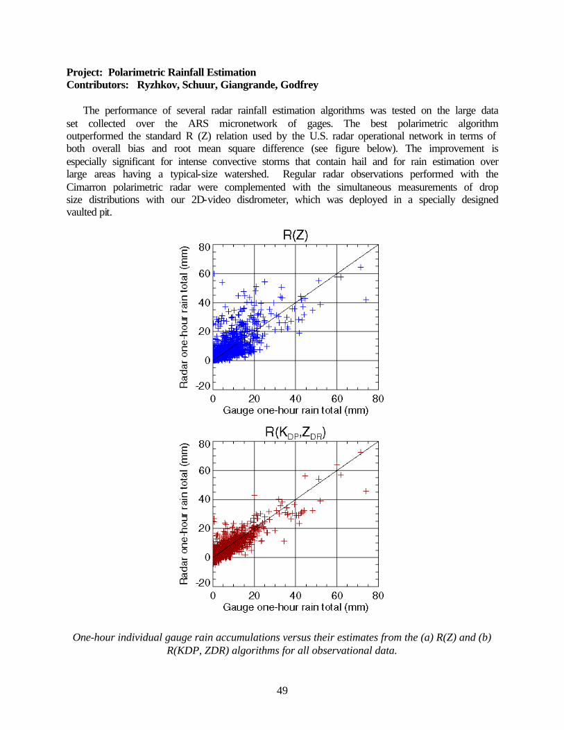
49
Project: Polarimetric Rainfall Estimation Contributors: Ryzhkov, Schuur, Giangrande, Godfrey
The performance of several radar rainfall estimation algorithms was tested on the large data set collected over the ARS micronetwork of gages. The best polarimetric algorithm outperformed the standard R (Z) relation used by the U.S. radar operational network in terms of both overall bias and root mean square difference (see figure below). The improvement is especially significant for intense convective storms that contain hail and for rain estimation over large areas having a typical-size watershed. Regular radar observations performed with the Cimarron polarimetric radar were complemented with the simultaneous measurements of drop size distributions with our 2D-video disdrometer, which was deployed in a specially designed vaulted pit.
One-hour individual gauge rain accumulations versus their estimates from the (a) R(Z) and (b) R(KDP, ZDR) algorithms for all observational data.
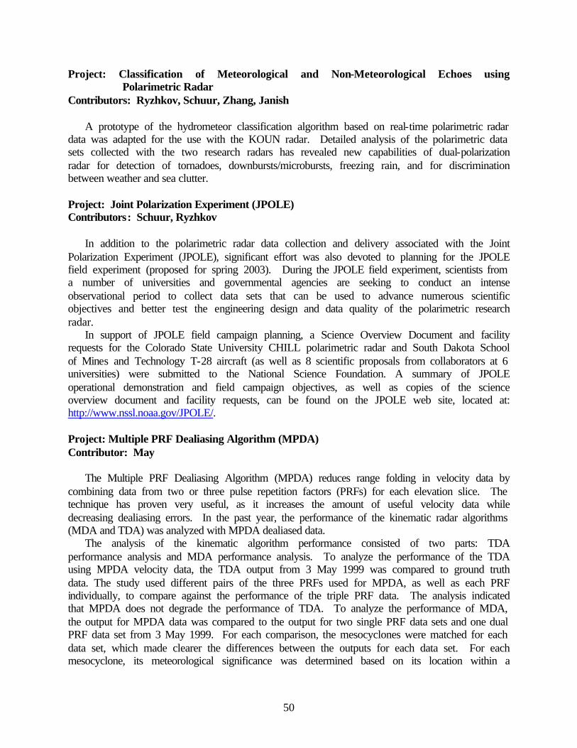
50
Project: Classification of Meteorological and Non-Meteorological Echoes using Polarimetric Radar
Contributors: Ryzhkov, Schuur, Zhang, Janish
A prototype of the hydrometeor classification algorithm based on real-time polarimetric radar data was adapted for the use with the KOUN radar. Detailed analysis of the polarimetric data sets collected with the two research radars has revealed new capabilities of dual-polarization radar for detection of tornadoes, downbursts/microbursts, freezing rain, and for discrimination between weather and sea clutter. Project: Joint Polarization Experiment (JPOLE) Contributors: Schuur, Ryzhkov
In addition to the polarimetric radar data collection and delivery associated with the Joint Polarization Experiment (JPOLE), significant effort was also devoted to planning for the JPOLE field experiment (proposed for spring 2003). During the JPOLE field experiment, scientists from a number of universities and governmental agencies are seeking to conduct an intense observational period to collect data sets that can be used to advance numerous scientific objectives and better test the engineering design and data quality of the polarimetric research radar.
In support of JPOLE field campaign planning, a Science Overview Document and facility requests for the Colorado State University CHILL polarimetric radar and South Dakota School of Mines and Technology T-28 aircraft (as well as 8 scientific proposals from collaborators at 6 universities) were submitted to the National Science Foundation. A summary of JPOLE operational demonstration and field campaign objectives, as well as copies of the science overview document and facility requests, can be found on the JPOLE web site, located at: http://www.nssl.noaa.gov/JPOLE/. Project: Multiple PRF Dealiasing Algorithm (MPDA) Contributor: May
The Multiple PRF Dealiasing Algorithm (MPDA) reduces range folding in velocity data by combining data from two or three pulse repetition factors (PRFs) for each elevation slice. The technique has proven very useful, as it increases the amount of useful velocity data while decreasing dealiasing errors. In the past year, the performance of the kinematic radar algorithms (MDA and TDA) was analyzed with MPDA dealiased data.
The analysis of the kinematic algorithm performance consisted of two parts: TDA performance analysis and MDA performance analysis. To analyze the performance of the TDA using MPDA velocity data, the TDA output from 3 May 1999 was compared to ground truth data. The study used different pairs of the three PRFs used for MPDA, as well as each PRF individually, to compare against the performance of the triple PRF data. The analysis indicated that MPDA does not degrade the performance of TDA. To analyze the performance of MDA, the output for MPDA data was compared to the output for two single PRF data sets and one dual PRF data set from 3 May 1999. For each comparison, the mesocyclones were matched for each data set, which made clearer the differences between the outputs for each data set. For each mesocyclone, its meteorological significance was determined based on its location within a
51
storm. These mesocyclones were then classified as significant, marginally significant, and non-significant. The results indicate that MPDA results in more meteorologically significant mesocyclones. Project: Beam Multiplexing Using Electronic Scanning Contributor: Curtis
In beam multiplexing, several directions are repeatedly revisited by the radar antenna during the dwell time. Thus, the multiplexed returns from the same direction are nearly uncorrelated, meaning that the spectral moment estimates have lower variances. In certain types of Doppler radars, a parabolic antenna rotates in azimuth at a fixed elevation. The only practical way to obtain estimates is to transmit a continuous stream of pulses while rotating. An electronically scanned array is not limited to pointing the beam in the mechanically steered direction, thus allowing beam multiplexing and other novel scanning strategies. General beam-multiplexing scanning strategies were developed to address issues such as side lobe interference for second and third trip echoes. These strategies are based on basic scanning patterns that can be adapted to fit a variety of situations. Theoretical formulas were used to measure the performance of scanning strategies that could decrease scan times by a factor of about two. These formulas were also double checked using Monte Carlo simulations. Additional considerations including low signal-to-noise ratios and beam broadening were also addressed. See figure below.
1 2 3 4 5 6 7 80
20
40
60
80
100
120
Spectrum Width (m s-1 )
Number of Pulses Needed at 20 dB SNR
ContiguousIndependent
Number of pulses needed to meet current standard deviation limits at 20 dB SNR.

52
Project: Improvement of Spectral Moment and Polarimetric Variable Estimates using a Whitening Transformation on Oversampled Range Data
Contributors: Ivic, Torres
Range oversampling followed by a whitening transformation is a novel method for the estimation of the Doppler spectrum, its moments, and several polarimetric variables on pulsed weather radars. The scheme operates on oversampled echoes in range, and the base-data products are estimated by suitably combining weighted averages of these oversampled signals with usual pulse-pair processing of the combined samples (spaced at pulse repetition time) at a fixed range location. The weights in range are derived from a whitening transformation; hence, the oversampled signals become uncorrelated and consequently the variance of the estimates obtained from these decreases significantly.
During the past year we developed the theory behind this technique and showed that since estimate errors are inversely proportional to the volume scanning times, it follows that storms can be surveyed much faster than is possible with current processing methods, or equivalently, for the current volume scanning time, accuracy of the estimates can be greatly improved, both of which are important considerations in WSR-88D operations. In addition, we performed a few preliminary tests on real oversampled data obtained with a SIGMETs digital receiver. These tests corroborated results obtained from simulations and our theoretical analyses (see figure below).
Standard deviation of reflectivity factor for three estimation methods.
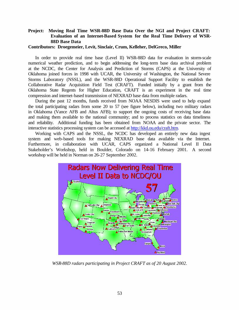
53
Project: Moving Real Time WSR-88D Base Data Over the NGI and Project CRAFT: Evaluation of an Internet-Based System for the Real Time Delivery of WSR-88D Base Data
Contributors: Droegemeier, Levit, Sinclair, Crum, Kelleher, DelGreco, Miller
In order to provide real time base (Level II) WSR-88D data for evaluation in storm-scale numerical weather prediction, and to begin addressing the long-term base data archival problem at the NCDC, the Center for Analysis and Prediction of Storms (CAPS) at the University of Oklahoma joined forces in 1998 with UCAR, the University of Washington, the National Severe Storms Laboratory (NSSL), and the WSR-88D Operational Support Facility to establish the Collaborative Radar Acquisition Field Test (CRAFT). Funded initially by a grant from the Oklahoma State Regents for Higher Education, CRAFT is an experiment in the real time compression and internet-based transmission of NEXRAD base data from multiple radars.
During the past 12 months, funds received from NOAA NESDIS were used to help expand the total participating radars from some 20 to 57 (see figure below), including two military radars in Oklahoma (Vance AFB and Altus AFB); to support the ongoing costs of receiving base data and making them available to the national community; and to process statistics on data timeliness and reliability. Additional funding has been obtained from NOAA and the private sector. The interactive statistics processing system can be accessed at http://kkd.ou.edu/craft.htm.
Working with CAPS and the NSSL, the NCDC has developed an entirely new data ingest system and web-based tools for making NEXRAD base data available via the Internet. Furthermore, in collaboration with UCAR, CAPS organized a National Level II Data Stakeholder’s Workshop, held in Boulder, Colorado on 14-16 February 2001. A second workshop will be held in Norman on 26-27 September 2002.
WSR-88D radars participating in Project CRAFT as of 20 August 2002.
54
Project: Real-Time NGI-Based Direct Ingest and Archive of WSR-88D Base Data as a Prototype for a National System
Contributors: Levit, Kelleher, Varahan
A robust and complete archive of WSR-88D data offers many opportunities for furthering our understanding of precipitating weather systems, and for developing climatologies at spatial and temporal scales heretofore unexplored. During the past twelve months, this project has focused on creating data mining algorithms for phenomena detection using several different strategies. Given that the NCDC WSR-88D Level II archive is very large (dozens of terabytes), and that researchers desire to use some type of on-line browser or simple program to peruse the data, much of the data mining effort has emphasized the development of rapid search and sort algorithms that will detect particular weather features or phenomena (e.g., supercells, squall lines, snow bands).
The first such strategy involved the installation of the NSSL WDSS algorithms on a local server, in collaboration with the OU Mesocyclone Climatology Project, and this software offered insight into using particular robust algorithms to detect storm-scale events. However, due to computational efficiency issues, it was determined that faster, yet possibly less accurate algorithms would be needed to serve the ultimate goals of the project. Therefore, the University of Alabama-Huntsville was contracted to develop a pattern recognition algorithm for mesocylones using their ADaM data-mining engine, while CAPS and OU School of Computer Science is investigating more numerically based, rapid detection algorithms. The final package is intended to serve as a prototype system that will allow for the rapid identification of particular phenomena for case study analysis, verification, and climatologies. The ultimate vision for this system is a complete software solution, where meteorologists can rapidly search and sort a set of phenomenological parameters to obtain particular base data volume scans of interest. Plans - FY03 Project: High Resolution Radar Analysis for Aviation Weather Hazard Characterization Contributors: Brewster, Gao, Shapiro, Kemp, Thomas, Robinson, Said
Software development for CRAFT Level-II radar ingests into the CAPS 3D-VAR and the Shapiro variational scheme will be completed. Final modifications to the ADAS cloud analysis scheme will be made to address the assignment of cloud water in the presence of precipitating hydrometeors in the most rigorous way possible.
A real-time demonstration period is planned for fall 2002 over the same domain used in early spring 2002. Separately, comparisons of wind analyses from the ADAS, 3D-VAR and Shapiro schemes will be performed for significant cases from the spring and fall trial periods. Turbulence and icing will be verified from automated and manual aircraft reports to the extent possible.
55
Project: Radar Research at the Radar Operations Center Contributors: Ray and ROC Graduate Students
During the upcoming year, several students will collaborate with CIMMS and ROC meteorologists to study methods of tracking severe convection using radar data. This research will assist other scientists to study the development and movement of severe convection. Project: Polarimetric Radar Development Contributors: Melnikov, Ryzhkov, Schuur, Krause, Carter
We will continue to conduct regular observations with the KOUN radar. Further, engineering evaluation, radar calibration issues, and overlaying radar products (such as rainfall accumulations and results of automatic classification) with ground-truth information (including raingage data from different networks) in the same display will be the focus of our research efforts. Project: Polarimetric Rainfall Estimation Contributors: Ryzhkov, Schuur, Giangrande, Godfrey
We will capitalize on the real-time comparison of rainfall estimates from the KOUN radar, ARS, and the Oklahoma mesonet to optimize the polarimetric rainfall algorithm. We will capitalize on unique capabilities of a dual-polarization radar to identify bright band contamination and to retrieve unbiased radar variables in the presence of a partial beam blockage, to improve the performance of the rainfall estimation algorithm at large distances from the radar. Project: Classification of Meteorological and Non-Meteorological Echoes using
Polarimetric Radar Contributors: Ryzhkov, Schuur, Zhang, Janish
We plan to increase the number of hydrometeor classes that will be identified in the prototype of the automatic classification algorithm that uses real-time data. Meteorological classes prevailing during the cold season, such as bright band, dry and wet snow, and snow crystals, will be included in the scheme. We will make better use of the polarimetric data collected at higher levels in the storm by further expanding and diversifying antenna-scanning strategy. Project: Joint Polarization Experiment (JPOLE) Contributors: Schuur, Ryzhkov
JPOLE test data collection will continue through the spring of 2003. During this test phase, polarimetric data from the research radar will be shared with forecasters at the Norman, OK NWS Forecast Office to allow them to evaluate the usefulness of this research data. CIMMS scientists will assist operational forecasters in the interpretation and use of polarimetric radar data. We will also continue planning for the JPOLE field campaign.
56
Project: Multiple PRF Dealiasing Algorithm (MPDA) Contributors: May
Over the next year, work will continue to improve the accuracy of the MPDA, as well as using it to analyze different types of severe storms. Project: Beam Multiplexing Using Electronic Scanning Contributors: Curtis
The main objective for the next year is to adapt the basic beam-multiplexing scanning patterns to the National Weather Radar Testbed (NWRT). Scanning strategies for various scenarios will be developed and compared to existing WSR-88D scanning strategies. Project: Improvement of Spectral Moment and Polarimetric Variable Estimates Using a
Whitening Transformation on Over Sampled Range Data Contributors: Ivic, Torres
When established as operationally viable, the whitening technique on range oversampled data will allow substantial estimate variance reduction and/or faster data acquisition rates. This could be advantageously exploited by a combination of faster data temporal acquisition and denser spatial sampling as needed to satisfy some of the evolutionary requirements for the RDA. Plans for next year include testing the oversampling and whitening technique on data acquired with our research RDA using the long pulse mode of the WSR-88D radar. In addition, we will investigate several practical aspects of this technique and optimum ways to perform the whitening. 6. Climate Change Monitoring and Detection Progress – FY02
No progress was made during the fiscal year due to special award conditions placed on our cooperative agreement for work within this research theme. These conditions have since been removed. Plans – FY03
The new research collaboration between CIMMS and the NCDC will involve basic inquiry necessary for improved climate change monitoring and detection in the United States. Climate monitoring is part of NCDC’s mission; any improved monitoring capabilities resulting from basic research interactions between CIMMS and NCDC would be transitioned to NCDC’s Climate Monitoring Branch.
There are many new sources of data, and new combinations of existing data, that can and should be mined for climate change monitoring and detection. However, NCDC’s mission and staff are necessarily operationally oriented. It is anticipated that research collaboration between CIMMS (which has a successful track record in climate diagnostic research) and NCDC would lead toward discovery of innovative techniques and monitoring capabilities utilizing the new data

57
sources. Such techniques could greatly enhance NCDC’s operational monitoring and detection capabilities. Projects would be multi-year, multi-scientist efforts involving graduate students at OU. With the tremendous influx of new data, opportunities for additional work should abound. III. PUBLIC AFFAIRS AND OUTREACH Progress – FY02 Project: Educational Outreach Activities Contributors: Zaras, Elmore, Tarp, Schultz, Spencer, Rasmussen, Smith
CIMMS outreach activities during the past year included the following:
• Mentored 10th grade student in Ohio on science fair project • Wrote Weather Watch column for Canoe & Kayak magazine • Participated as EARTHSTORM mentor for schools throughout Oklahoma • Visited with prospective OU students • Visited with about 200 members of the general public about CIMMS activities at NSSL • Answered several hundred email letters from the general public about CIMMS research • Represented CIMMS at several career fairs • Featured speaker at the American Meteorological Society's first-ever “WeatherFest” • Talked with 3rd and 5th grade classes at an elementary school in Colorado • Hosted area high school students in job shadow activities • Spoke to a summer youth program about CIMMS tornado research and safety • Facilitated interviews from newspapers and television stations across the country and
abroad about CIMMS research activities • Coordinated the joint NSSL/CIMMS display at the American Meteorological Society's
2002 Annual Meeting in Orlando, Florida • Worked with a teacher from Minnesota to develop tornado and severe weather curricula • Spoke at the National Science Teachers Association Annual Meeting on ideas to
incorporate real research into math and science classes Project: NSF Research Experiences for Undergraduates Contributors: Zaras, Elmore, Schultz, Johns, Wood, Peppler
CIMMS researchers continued to manage the NSF Research Experiences for Undergraduates Program in Meteorology at the University of Oklahoma. Another successful 10-week program was conducted during the summer of 2002 involving 10 undergraduate students from across the country. Each student participated in the IHOP field project in addition to regular REU activities. A committee including Zaras, Peppler, Schultz, Wood, and Johns selected students, and Elmore served as a student mentor during the program. Each student worked with a CIMMS, OU, or NOAA mentor on a research project, wrote a 10-page paper, and made a conference-style presentation on his/her findings. Recruitment for the 2002 REU Program began in December 2001. A large number of our REU alumni have received American Meteorological Society awards and fellowships.
58
Plans – FY03 Project: Educational Outreach Activities Contributors: Zaras, Elmore, Tarp, Schultz, Spencer, Rasmussen, Smith
We plan to continue informally promoting our research to the general public through classrooms and other outreach activities. Project: NSF Research Experiences for Undergraduates Contributors: Zaras, Elmore, Schultz, Johns, Wood, Peppler
The current REU grant continues through 2003. Recruitment for REU 2003 will begin in December 2002, with student selection occurring in early spring 2003. IV. COMPUTER SUPPORT Computer Support Activities Related to CIMMS at the National Severe Storms Laboratory
The management and administration of computers, network, and computer-related security for CIMMS scientists at NSSL is accomplished by the Information and Technology Services (ITS) group. Equipment consists of Linux-based systems, a significant number of Windows-based and Macintosh clients, as well as a number of UNIX systems, most of which are Solaris-based.
CIMMS scientists have completed development of an advanced data compression algorithm prototype and have tested the feasibility of using such an algorithm to compress data for transport on a testbed network of Doppler radar systems. This testbed has proved the concept that archiving Doppler radar data can be accomplished on a nationwide basis by way of networks.
The ITS spent much time early in the year reconfiguring the local network and completing installation of a firewall system that protects computers on the network from intrusions and compromises. Much less time this year was spent on investigating system compromises and repairing damage to systems.
The ITS also supported IHOP by providing logistical support in the areas of space, computing, networking, telecommunications, and the web. Computer Support Activities Related to CIMMS at the Radar Operations Center
Key responsibilities of CIMMS personnel associated with this project included user support, data management, systems analysis, and network administration of computers and peripherals used by CIMMS Research Associates and graduate students at ROC. Because of a reduction in CIMMS staff at the ROC, this activity will cease to continue.
59
V. PUBLICATIONS (Formal Refereed and Informal Non-Refereed) Adler, R. F., C. Kidd, G. Petty, M. Morrissey, and H. M. Goodman, 2002: Intercomparison of
global precipitation products: The Third Precipitation Intercomparison Project (PIP-3). Bull. Amer. Meteor. Soc., in press.
Bahrmann, C. P., R. A. Peppler, K. Sonntag, A. Dean, and S. Moore, 2002: Atmospheric
Radiation Measurement (ARM) Program data quality inspection and assessment activities: A streamlined approach. Preprints, 18th International Conference on Interactive Information and Processing Systems (IIPS) for Meteorology, Oceanography, and Hydrology, Orlando, 13-17 January 2002, American Meteorological Society, 212-214.
Bahrmann, C. P., R. A. Peppler, K. Sonntag, A. Dean, S. Moore, and S. Bottone, 2002: ARM
Program data quality inspection and assessment activities: A streamlined approach. Proc., Twelfth Atmospheric Radiation Measurement (ARM) Science Team Meeting, St. Petersburg, FL, 8-12 April 2002, U.S. Dept. of Energy.
Baldwin, M. E., S. Lakshmivarahan, and J. S. Kain, 2001: Verification of mesoscale features in
NWP models. Preprints, 9th Conf. on Mesoscale Processes, Ft. Lauderdale, FL, Amer. Meteor. Soc., 255–258.
Baldwin, M. E., and S. Lakshmivarahan, 2002: Rainfall classification using histogram analysis:
An example of data mining in meteorology. Proc. of the Artificial Neural Networks in Engineering Conference, 10-13 November 2002, St. Louis Missouri.
Baldwin, M. E., J. S. Kain, and M. P. Kay, 2002: Properties of the convection scheme in
NCEP's Eta Model that affect forecast sounding interpretation. Wea. Forecasting., in press. Bi, L., A. Shapiro, P. Zhang, W. Collins, and Q. Xu, 2002: Quality control problems for VAD
winds and NEXRAD Level-II winds in the presence of migrating birds. Preprints, 19th Conf. on Weather Analysis and Forecasting and 15th Conf. on Numerical Weather Prediction, 2 - 16 August, 2002, San Antonio, TX, Amer. Meteor. Soc., 143-145.
Brandes, E. A., A. V. Ryzhkov, and D. S. Zrnic, 2001: An evaluation of radar rainfall estimates
from specific differential phase. J. Atmos. and Oceanic Technol., 18, 363–375. Brewster, K., 2002: Recent advances in the diabatic initialization of a non-hydrostatic numerical
model. Preprints, 21st Conf. on Severe Local Storms, Preprints, 15th Conf. Num. Wea. Pred., and Preprints, 19th Conf. Wea. Anal. Forecasting, San Antonio, TX, Amer. Meteor. Soc., J51-J54.
Brewster, K. A., 2002a: Phase-correcting data assimilation and application to storm scale
numerical weather prediction. Part I: Method description and simulation testing. Mon. Wea. Rev., accepted.
60
Brewster, K. A., 2002b: Phase-correcting data assimilation and application to storm scale numerical weather prediction. Part II: Application to a Severe Storm Outbreak. Mon. Wea. Rev., accepted.
Brooks, H. E., and C. A. Doswell III, 2002: Deaths in the 3 May 1999 Oklahoma City tornadoes
from a historical perspective. Wea. Forecasting, 17, 354-361. Burgess, D. W., M. A. Magsig, J. Wurman, D. Dowell, and Y. Richardson, 2002: Radar
observations of the May 3, 1999 Oklahoma City tornado, Wea. Forecasting, 17, 456–471. Burgess, D., M. Magsig, J. Wurman, D. Dowell, and Y. Richardson, 2001: A comparison of
WSR-88D and DOW radar observation of the 3 May 1999 Oklahoma City Tornado. Preprints, 30th Inter. Conf. On Radar Meteor., AMS, Munich, Germany, 301–303.
Burgess, D., P. Joe, R. Potts, T. Keenan, P. May, D. Mitchell, B. Conway, A. Treloar, D. Sills,
and D. Hudak, 2001: Severe storm detection algorithms for S2000 Project. Preprints, 30th Inter. Conf. On Radar Meteor., AMS, Munich, Germany, 483–485.
Coniglio, M. C., and D. J. Stensrud, 2001: Simulation of a progressive derecho using composite
initial conditions. Mon. Wea. Rev., 129, 1593–1616. Cortinas, J. V., Jr., K. F. Brill, and M. E. Baldwin, 2002: Probabilistic forecasts of precipitation
type. Preprints, 16th Conf. on Probability and Statistics in the Atmospheric Sciences, Orlando, FL, AMS, 140–145.
Doswell III, C. A., and H. E. Brooks, 2002: Lessons learned from the damage produced by the
tornadoes of 3 May 1999. Wea. Forecasting, 17, 611-618. Droegemeier, K. K., K. Kelleher, T. D. Crum, J. Levit, S. A. DelGreco, L. Miller, C. Sinclair, M.
Benner, S. W. Fulker, and H. Edmon: Project CRAFT: A test bed for demonstrating the real time acquisition and archival of WSR-88D Level II Data, Preprints, 18th IIPS, Orlando, FL, Amer. Meteor. Soc., 136–139.
El Hamly, M., P. J. Lamb, and D. H. Portis, 2001: Decadal variability in the North Atlantic
Ocean involving ocean-atmosphere interactions. Eos. Trans. AGU, 82(47), Fall Meet. Suppl., Abstract A32A-0031.
El Hamly, M., P. J. Lamb, and D. H. Portis, 2001: North Atlantic winter storm track variability
and associations with monthly regional climate variations, Proc. of the U.S. CLIVAR Meeting, Boulder, Colorado, 12-14 June, 2001, United States US CLIVAR Project, Washington, D.C., 54-57.
Elmore, K. L., D. J. Stensrud and K. C Crawford, 2002: Ensemble cloud model applications to
forecasting thunderstorms. J. Appl. Meteor., 41, 363–383.
61
Elmore, K. L., D. J. Stensrud, and K. C. Crawford, 2002: Cloud scale model forecasts: Extreme sensitivity to environmental conditions. Wea. Forecasting, 17, 873–884.
Evans, J. S., and C. A. Doswell III, 2002: Investigating derecho and supercell proximity
soundings. Preprints, 21st Conf. Severe Local Storms, San Antonio, TX, Amer. Meteor Soc. Ferree, J. T., E. M. Quoetone, and M. A. Magsig, 2002: Using the warning environment
simulator. Interactive Symposium on AWIPS, Orlando, FL, Amer. Meteor. Soc., J212–2213. Fiedler, A. H., and K. M. Kanak 2001: Rayleigh-Benard convection as a tool for studying dust
devil formation. Atmos. Sci. Lett., Royal Meteor. Soc., 10.1006/asle.2001.0043. Gao, J., M. Xue, K. Brewster, F. Carr, and K. K. Droegemeier, 2001: The three-dimensional
variational data assimilation scheme for a storm-scale model. Preprints, 14th Conf. Num. Wea. Pred., Amer. Meteor. Soc., Ft. Lauderdale, FL. J71-J73.
Gao, J., M. Xue, K. K. Droegemeier, 2002: A three-dimensional variational single-Doppler
velocity retrieval method with simple conservation equation constraint, Quart. J. Royal Meteor. Soc., submitted.
Gao, J., M. Xue, K. Brewster, F. Carr, and K. K. Droegemeier, 2002: New development of a
3DVAR system for a nonhydrostatic NWP model. Preprints, 15th Conf. Num. Wea. Pred. and 19th Conf. Wea. Anal. Forecasting, San Antonio, TX, Amer. Meteor. Soc., 339-342.
Gilmore, M. S., and L. J. Wicker, 2002: Influences of the local environment on supercell cloud-
to-ground lightning, radar characteristics, and severe weather on 2 June 1995. Mon. Wea. Rev., 130, 2349–2372.
Gilmore, M. S., E. N. Rasmussen, and J. M. Straka, 2001: Quantitative precipitation sensitivity
in simulated deep convective storms due to variations in the particle density and size distribution for the "large ice" category, Eos Trans. AGU, 82(47), Fall Meet. Suppl., Abstract A11A–27.
Godfrey, C. M., D. S. Wilks, and D. M. Schultz, 2002: Is the January Thaw a statistical
phantom? Bull. Amer. Meteor. Soc., 83, 53–62. Gourley, J. J., A. T. Arthur, J. Zhang, R. A. Maddox, K. W. Howard, and T. Vasquez, 2001:
QIWI - A web-based flash flood monitoring tool. Preprints, Thirtieth Intl. Conf. on Radar Meteor., Munich, Germany, Amer. Meteor. Soc., 17–19.
Gourley, J. J., R. A. Maddox, D. W. Burgess, and K. W. Howard, 2002: An exploratory multisensor technique for quantitative estimation of stratiform rainfall. J. Hydrometeor., 3, 166–180.
62
Hane, C. E., R. M. Rabin, T. M. Crawford, H. B. Bluestein, and M. E. Baldwin, 2002: A case study of severe storm development along a dryline within a synoptically-active environment. Part II: Multiple boundaries and convective initiation. Mon. Wea. Rev., 130, 900–920.
Hanstrum, B. N., G. A. Mills, A. Watson, J. P. Monteverdi and C. A. Doswell III, 2002: The
cool-season tornadoes of California and southern Australia. Wea. Forecasting, 17, 705-722. Holle, R. L., R. E. López, and B. C. Navarro, 2001: U.S. Lightning deaths, injuries, and damages
in the 1890s compared to 1990s. NOAA Tech. Memo. OAR NSSL-106, 54 pp. Huffman, G. J., R. F. Adler, M. Morrissey, D. T. Bolvin, S. Curtis, R. Joyce, B. McGavock, and
J. Susskind, 2001: Global precipitation at one-degree daily resolution from multi-satellite observations. J. Hydrometeor., 2, 36-50.
Ivic, I., S. Torres, and D. S. Zrnic, 2002: Demonstration of optimum processing of oversampled
data in range to improve Doppler spectral moment estimates. Preprints, 18th International Conference on Interactive Information and Processing Systems (IIPS) for Meteorology, Oceanography, and Hydrology, Orlando, FL. American Meteorological Society, 142–144.
Kain, J. S., M. E. Baldwin, P. Janish, and S. J. Weiss, 2001: Utilizing the Eta Model with two
different convective parameterizations to predict convective initiation and evolution at the SPC. Preprints, 9th Conf. on Mesoscale Processes, Ft. Lauderdale, FL, Amer. Meteor. Soc., 91–95.
Kain, J. S., M. E. Baldwin, and S. J. Weiss, 2002: Parameterized updraft mass flux as a predictor
of convective intensity. Wea. Forecasting., accepted. Kain, J. S., M. E. Baldwin, S. J. Weiss, and M. P. Kay, 2002: The impact of parameterized
shallow convection on pre-deep-convective sounding structures in the Eta model. Preprints, 15th Conference on Numerical Weather Prediction, San Antonio, TX, Amer. Meteor. Soc., 135-138.
Kain, J. S., M. E. Baldwin, and S. J. Weiss, P. R. Janish, J. A. Hart, and A. Just, 2002:
Grassroots science and technology transfer in a collaborative research/operational environment. Preprints, 15th Conference on Numerical Weather Prediction, San Antonio, TX, Amer. Meteor. Soc., J1-J6.
Kain, J. S., M. E. Baldwin, and S. J. Weiss, P. R. Janish, M. P. Kay, and G. Carbin, 2003:
Subjective verification of numerical models as a component of a broader interaction between research and operations. Wea. Forecasting., accepted.
Kain, J. S., M. E. Baldwin, and S. J. Weiss, P. R. Janish, M. P. Kay, G. Carbin, and L. Brown,
2002: Subjective verification of numerical models as a component of a broader interaction between research and operations. Preprints, 15th Conference on Numerical Weather Prediction, San Antonio, TX, Amer. Meteor. Soc., J25-J28.
63
Kain, J. S., P. R. Janish, S. J. Weiss, M. E. Baldwin, R. S. Schneider, and H. E. Brooks, 2003: Collaboration between forecasters and research scientists at the NSSL and SPC. Submitted to Bull. Amer. Meteor. Soc.
Kanak, K. M., D. K. Lilly, and J. T. Snow, 2002: The formation of vertical vortices in the
convective boundary layer. 15th International Symposium on Boundary Layers and Turbulence, The Netherlands, July 2002, AMS. 76-79.
Kanak, K. M., and J. M. Straka 2002: An unusual reticular cloud formation. Mon. Wea. Rev.,
130, 416-421. Kanak, K. M. 2001: Book Review: Currents of change: Impacts of El Nino and La Nina on
climate and society. Second edition. by Michael Glantz. Cambridge University Press, Cambridge, UK, 2001, 252 pages, Atmos. Res., 58, 71-74.
Lan, Y., Y. Kogan, and D. Mechem, 2002: The effect of continental air outbreaks on marine
stratocumulus drizzle formation and cloud breakup. Preprints, 11th Conference on Cloud Physics. Ogden, Utah, 3-7 June 2002.
Lin, Y., M. E. Baldwin, K. E. Mitchell, E. Rogers, and G. J. DiMego, 2001: Spring 2001 changes
to NCEP Eta analysis and forecast system: Assimilation of observed precipitation data. Preprints, 9th Conf. on Mesoscale Processes, Ft. Lauderdale, FL, Amer. Meteor. Soc., J92–J95.
Liu, S., C. Qiu, and Q. Xu, 2002: A variational method for dual-Doppler radar retrievals of wind
and thermodynamic fields. Preprints, 21th Conf. on Severe Local Storms, 2 - 16 August, 2002, San Antonio, TX, Amer. Meteor. Soc., J145-146.
Luterbacher, J., E. Xoplaki, D. Dietrich, P. D. Jones, T. D. Davies, D. Portis, J. F. Gonzalez
Rouco, H. von Storch, D. Gyalistras, C. Casty, and H. Wanner, 2002. Extending North Atlantic Oscillation reconstructions back to 1500. Atmos. Sci. Lett., 10.1006/asle.2001.0044.
MacKeen, P. L., K. W. Howard, and D. M. Schultz, 2001: Initiation and evolution of
summertime storms in central Arizona. Preprints, 30th Intl Conf on Radar Meteorology, Munich, Germany, 676–678.
Maddox, R. A., J. Zhang, J. J. Gourley, and K. W. Howard, 2002: Weather radar coverage over
the contiguous United States. Wea. Forecasting, 17, 927–934. Magsig, M. A. and E. Page, 2002: Development and implementation of the warning environment
simulator version 1.0, Interactive Symposium on AWIPS, Orlando, FL. Amer. Meteor. Soc., J236–238.
Mahmood, R., M. Morrissey, D. Legates, and M. Meo, 2002: Potential monsoon season rainfed
rice productivity in Bangladesh. Professional Geographer, accepted.
64
Mansell, E. R., D. R. MacGorman, C. L. Ziegler, and J. M. Straka, 2002: Simulated three-dimensional branched lightning in a numerical thunderstorm model. J. Geophys. Res., 107 (9), 10.1029/2000JD000244.
Markowski, P. M., J. M. Straka, and E. N. Rasmussen, 2002: Direct surface thermodynamic
observations within the rear-flank downdrafts of nontornadic and tornadic supercells. Mon. Wea. Rev., 130, 1692–1721.
Mechem, D. B., M. Ovtchinnikov, Y. L. Kogan, A. B. Davis, R. F. Cahalan, E. E. Takara, and R.
G. Ellingson, 2002: Large eddy simulation of PBL stratocumulus: Comparison of multi-dimensional and IPA longwave radiative forcing. Proc. Of the Twelfth Atmospheric Radiation Measurement (ARM) Science Team Meeting, 8-12 April 2002, St. Petersburg, FL.
Mechem, D. B., M. Ovtchinnikov, Y. L. Kogan, A. B. Davis, R. F. Cahalan, E. E. Takara, and R.
G. Ellingson, 2002: Multi-dimensional broadband IR radiative forcing of marine stratocumulus in a large eddy simulation model. Preprints, 11th Conference on Cloud Physics, 3-7 June 2002, Ogden, UT, Amer. Meteor. Soc.
Melnikov, V., and R. Doviak, 2001: Spectrum width patterns. Preprints, 17th Conf. on
Interactive Processing Systems for Meteorology, Albuquerque, New Mexico, Amer. Meteor. Soc., 250–254.
Melnikov, V., and R. Doviak, 2001: Spectrum width patterns in precipitation. Preprints, 30th
Conf. Radar Meteorology, Munich, Germany, Amer. Meteor. Soc., 379–381. Merrell, D., K. M. Simmons, and D. Sutter, 2002: Taking shelter: Estimating the safety benefits
of tornado safe rooms. Wea. Forecasting, 17, 619-625. Monteverdi, J. P., W. Blier, G. J. Stumpf, W. Pi, and K. Anderson, 2001: First WSR-88D
documentation of a an anticyclonic supercell with anticyclonic tornadoes: the Sunnyvale/Los Altos tornadoes of 4 May 1998. Mon. Wea. Rev., 129, 2805-2814.
Nai, K., L. Wei, Q. Xu, and K. D. Sashegyi, and T. R. Holt, 2002: An improved model of soil-
vegetation physics for COAMPS. Preprints, 19th Conf. on Weather Analysis and Forecasting and 15th Conf. on Numerical Weather Prediction, 2 - 16 August, 2002, San Antonio, TX, Amer. Meteor. Soc., 72-73.
Page, E. M., R. J. Miller, M. A. Magsig, and T. Alberta, 2002: Archiving of AWIPS data in
National Weather Service offices, Interactive Symposium on AWIPS, Orlando, FL., Amer. Meteor. Soc., J214–215.
Peppler, R. A., K. L. Sonntag, A. R. Dean, C. P. Bahrmann, S. T. Moore, and S. Bottone, 2002:
dq.arm.gov: Future development of the ARM Data Quality Health and Status website (DQ HandS). Proc., Twelfth Atmospheric Radiation Measurement (ARM) Science Team Meeting, St. Petersburg, FL, 8-12 April 2002, U.S. Dept. of Energy.
65
Pietrycha, A. E., and E. N. Rasmussen, 2001: Observations of the Great Plains Dryline utilizing mobile mesonet data. Preprints, Ninth Conf. on Mesoscale Processes, Ft. Lauderdale, FL, Amer. Meteor. Soc., 452–456.
Portis, D. H., J. E. Walsh, M. El Hamly, and P. J. Lamb, 2001: Seasonality of the North Atlantic
Oscillation. J. Climate, 14, 2069-2078. Ren, D. and M. Xue, 2002a: An improved force-restore model for land surface modeling.
Abstract Volume, Mississippi River Climate and Hydrology Conf., New Orleans, Louisiana. Ren, D. and M. Xue, 2002b: An improved force-restore model for land-surface modeling. J.
Appl. Meteor., submitted. Ren, D., M. Xue, and J. Gao, 2002: Parameter retrieval in a land-surface model. Preprints, 15th
Conf. on Num. Wea. Pred., and 19th Conf. on Wea. Anal. Forecasting, San. Antonio, TX, Amer. Meteor. Soc.
Robbins, C. C., and J. V. Cortinas Jr., 2002: Local and synoptic environments associated with
freezing rain in the contiguous United States. Wea. and Forecasting,17, 47–65. Roebber, P. J., D. M. Schultz, and R. Romero, 2002: Synoptic regulation of the 3 May 1999
tornado outbreak. Wea. Forecasting, 17, 399–429. Ryzhkov, A. V., 2001: Interpretation of polarimetric radar covariance matrix for meteorological
scatterers. Theoretical analysis. J. of Atmos. and Oceanic Tech., 18, 315–328. Ryzhkov, A. V., S. Giangrande, and D. S. Zrnic, 2002: Using multiparameter data to calibrate
polarimetric weather radars in the presence of a partial beam blockage. Proc. IGARSS 2002, Toronto, Canada, 2820–2822.
Ryzhkov, A. V., T. J. Schuur, and D. S. Zrnic, 2001: Radar rainfall estimation using different
polarimetric algorithms. Preprints, 30th International Conf. on Radar Meteorology, Munich, Germany, 641–643.
Ryzhkov, A. V., T. J. Schuur, and D. S. Zrnic, 2001: Testing a polarimetric rainfall algorithm
and comparison with a dense network of rain gauges. Preprints, Fifth Intl. Symposium on Hydrological Applications of Weather Radar., Kyoto, Japan, 159–164.
Ryzhkov, A. V., J. M. Janish, T. J. Schuur, P. Zhang, and K. L. Elmore, 2002: Dual-polarization
radar as a tool for operational identification of different types of meteorological and non-meteorological targets. Preprints, 10th Conf. On Aviation, Range, and Aerospace Meteorology, 104–107.
66
Ryzhkov, A. V., P. Zhang, R. Doviak, and C. Kessinger, 2002: Discrimination between weather and sea clutter using Doppler and dual-polarization weather radars. XXVII General Assembly of the International Union of Radio Science, Maastricht, The Netherlands, CD-ROM paper # 1383.
Ryzhkov, A. V., D. S. Zrnic, J. C. Hubbert, V. N. Bringi, J. Vivekanandan, E. A. Brandes, 2002:
Polarimetric radar observations and interpretation of co-cross-polar correlation coefficients. J. Atmos. and Oceanic Technol., 19, 340–354.
Schultz, D. M., J. V. Cortinas Jr., and C. A. Doswell III, 2002: Comments on "An operational
ingredients-based methodology for forecasting midlatitude winter season precipitation". Wea. Forecasting, 17, 160–167.
Schultz, D. M., W. J. Steenburgh, R. J. Trapp, J. Horel, D. E. Kingsmill, L. B. Dunn, W. D. Rust,
L. Cheng, A. Bansemer, J. Cox, J. Daugherty, D. P. Jorgensen, J. Meitin, L. Showell, B. F Smull, K. Tarp, and M. Trainor, 2002: Understanding Utah winter storms: The Intermountain Precipitation Experiment. Bull. Amer. Meteor. Soc., 83, 189–210.
Schuur T. J., A. V. Ryzhkov, and D. S. Zrnic, 2001: A statistical analysis of 2D-video-
disdrometer data: impact on polarimetric rainfall estimation. Preprints, 30th Intl. Conf. on Radar Meteorology, Munich, Germany, 646–648.
Schuur T. J., A. V. Ryzhkov, D. S. Zrnic, and M. Schoenhuber, 2001: Drop size distributions
measured by a 2D video disdrometer: Comparison with dual-polarization radar data. J. Appl. Meteor., 40, 1019–1034.
Schuur T. J., D. S. Zrnic, and R. E. Saffle, 2001: The Joint Polarization Experiment - an
operational test of weather radar polarimetry. Preprints, 30th Int. Conf. Radar Meteorology, Munich, Germany, 722–723.
Shapiro, A., and K. M. Kanak, 2002: Vortex formation in elliptical thermal bubbles. J. Atmos.
Sci., 59, 2253-2269. Shapiro, A., and K. M. Kanak, 2001: Vortex formation in elliptical thermal bubbles. Proc.,
Third International Symposium on Environmental Hydraulics, Tempe, AZ, December 2001. Smith, J. A., M. L. Baeck, Y. Zhang and C. A. Doswell III, 2001: Extreme rainfall and flooding
from supercell thunderstorms. J. Hydrometeor., 2, 469-489. Speheger, D. A., C. A. Doswell III, and G. J. Stumpf, 2002: The tornadoes of 3 May 1999: Event
verification in central Oklahoma and related issues. Wea. Forecasting, 17, 362-381. Spencer, P. L., and C. A. Doswell III, 2001: A quantitative comparison between traditional and
line integral methods of derivative estimation. Mon. Wea. Rev., 129, 2538-2554.
67
Torres, S., and D. Zrnic, 2001: Spectral moment estimation for weather radars using a whitening transformation on oversampled data. Proc. International Conference on Acoustics, Speech, and Signal Processing, Salt Lake City, UT, Institute of Electrical and Electronics Engineers, vol. V, 2889–2992.
Torres, S., and D. Zrnic, 2001: Optimum processing in range to improve estimates of Doppler
and polarimetric variables on weather radars. Preprints, 30th International Conference on Radar Meteorology, Munich, Germany, Amer. Meteor. Society, 325–327.
Trapp, R. J., N. T Atkins, H. E. Fuelberg, J. G. LaDue, K. J. Pence, T. L. Smith, and G. J.
Stumpf, 2001: Meeting Summary, 20th Conference on Severe Local Storms. Bull. Amer. Soc., 82, 2251–2258.
Trapp, R. J., D. M. Schultz, A. V. Ryzhkov, and R. L. Holle, 2001: Multiscale structure and
evolution of an Oklahoma winter precipitation event. Mon. Wea. Rev., 129, 486–501. Wang, S., M. Yang, M. Liu, D. Westphal, K. D. Sashegyi, and Q. Xu, 2002: A case study of 7-9
April 2001 dust storm in northern China. Preprints, 21st Conf. on Severe Local Storms, 2 - 16 August, 2002, San Antonio, TX, Amer. Meteor. Soc., 85-86.
Wicker, L. J., M. S. Gilmore, E. N. Rasmussen, and J. M. Straka, 2001: Influences of the local
environment on supercell cloud-to-ground lightning, radar characteristics, and severe weather on 2 June 1995. Eos Trans. AGU, 82(47), Fall Meet. Suppl., Abstract AE12A–87.
Wu, W.-S., M. Xue, T. Schlatter, R. J. Purser, M. McAtee, J. Gao, D. Devenyi, J. C. Derber, D.
M. Barker, S. Benjamin, and R. Aune, 2001: The WRF 3DVAR analysis system. Preprints, 14th Conf. on Num. Wea. Pred., Amer. Met. Soc., Ft. Lauderdale, Florida.
Xu, Q., and L. Wei, 2002: Estimation of three-dimensional error covariances. Part III: Height-
wind error correlation and related geostrophy. Mon. Wea. Rev., 130, 1052-1062. Xu, Q., and W. Gu, 2002: Semigeostrophic frontal boundary layer. J. Bound.-Layer Meteor.,
104, 99-110. Xu, Q., and J. Gong, 2002: Background error covariance functions for radar wind analysis.
Preprints, 19th Conf. on Weather Analysis and Forecasting and 15th Conf. on Numerical Weather Prediction, 2 - 16 August, 2002, San Antonio, TX, Amer. Meteor. Soc., 286-287.
Yuan M., M. Dickens-Micozzi, and M. A. Magsig, 2002: Analysis of tornado damage on May
3rd, 1999 using remote sensing and GIS methods on high-resolution satellite imagery, Wea. Forecasting, 17, 382–398.
Zhang, J., J. J. Gourley, K. W. Howard, and R. A. Maddox, 2001: Three-dimensional gridding
and mosaic of reflectivities from multiple WSR-88D radars. Preprints, Thirteenth Intl Conf. on Radar Meteor., Munich, Germany, Amer. Meteor. Soc., 719–721.
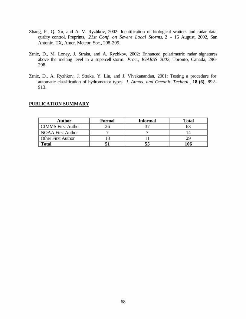
68
Zhang, P., Q. Xu, and A. V. Ryzhkov, 2002: Identification of biological scatters and radar data quality control. Preprints, 21st Conf. on Severe Local Storms, 2 - 16 August, 2002, San Antonio, TX, Amer. Meteor. Soc., 208-209.
Zrnic, D., M. Loney, J. Straka, and A. Ryzhkov, 2002: Enhanced polarimetric radar signatures
above the melting level in a supercell storm. Proc., IGARSS 2002, Toronto, Canada, 296-298.
Zrnic, D., A. Ryzhkov, J. Straka, Y. Liu, and J. Vivekanandan, 2001: Testing a procedure for
automatic classification of hydrometeor types. J. Atmos. and Oceanic Technol., 18 (6), 892–913.
PUBLICATION SUMMARY
Author Formal Informal Total CIMMS First Author 26 37 63 NOAA First Author 7 7 14 Other First Author 18 11 29 Total 51 55 106