Embed Size (px)
Citation preview

Coordinate SystemsCoordinate Systems

ReviewReviewReview Review
►►What is a Map Projection?What is a Map Projection?►►What is a Map Projection?What is a Map Projection?►►DatumsDatums
G hi C di t S tG hi C di t S t►►Geographic Coordinate SystemGeographic Coordinate System

What is a Map Projection?What is a Map Projection?What is a Map Projection?What is a Map Projection?
►►Transformation of 3D surface to 2D flat sheetTransformation of 3D surface to 2D flat sheet►►Transformation of 3D surface to 2D flat sheetTransformation of 3D surface to 2D flat sheet►►Causes distortion in the shape, area, distance or Causes distortion in the shape, area, distance or
direction of datadirection of datadirection of datadirection of data►►Uses mathematical formulas to relate spherical Uses mathematical formulas to relate spherical
coordinates to planar coordinatescoordinates to planar coordinatespp►►Different projections cause different distortionsDifferent projections cause different distortions►►Map projections designed for specific purposeMap projections designed for specific purpose ––►►Map projections designed for specific purpose Map projections designed for specific purpose
i.e. largei.e. large--scale data in limited areascale data in limited area

DatumsDatumsDatumsDatums
►►Spheroids approximate earth’s shapeSpheroids approximate earth’s shape►►Spheroids approximate earth s shapeSpheroids approximate earth s shape►►Datum defines position of spheroid relative Datum defines position of spheroid relative
to center of the earthto center of the earthto center of the earthto center of the earth►►Datum defines origin and orientation of Datum defines origin and orientation of
l t/l lil t/l lilat/long lineslat/long lines►►Local datum aligns spheroid to fit surface in Local datum aligns spheroid to fit surface in
a particular areaa particular area

Geographic Coordinate SystemGeographic Coordinate SystemGeographic Coordinate SystemGeographic Coordinate System
►►Uses 3D spherical surface to define Uses 3D spherical surface to define locationslocations
►►Often incorrectly called a datumOften incorrectly called a datum►►Includes angular unit of measure primeIncludes angular unit of measure prime►►Includes angular unit of measure, prime Includes angular unit of measure, prime
meridian and datummeridian and datumP i t f d b l it d /l tit dP i t f d b l it d /l tit d►►Point referenced by longitude/latitudePoint referenced by longitude/latitude
►►Angles measured by degreesAngles measured by degrees

Possible Error Associated with Possible Error Associated with Coordinate SystemsCoordinate Systemsyy

Comparison of 2 ProjectionsComparison of 2 ProjectionsComparison of 2 ProjectionsComparison of 2 Projections

Errors from ProjectionsErrors from ProjectionsErrors from ProjectionsErrors from Projections
►► because we are trying to represent a 3because we are trying to represent a 3--D sphere on a D sphere on a y g py g p pp22--D plane, D plane, distortion is inevitabledistortion is inevitable
►► thus,thus, everyevery two dimensional map is two dimensional map is inaccurateinaccurate with with respect torespect to at leastat least one of the following:one of the following:respect to respect to at least at least one of the following:one of the following:
areaareashapeshape
W ipp
distance distance directiondirection
We are trying to represent this amount of the earth on
this amount of map space.

General Classes of ProjectionsGeneral Classes of ProjectionsGeneral Classes of ProjectionsGeneral Classes of Projections
►►CylindricalCylindrical►►CylindricalCylindricaltangent case, secant case, transverse tangent tangent case, secant case, transverse tangent case, oblique tangent casecase, oblique tangent case, q g, q g
►►ConicConictangent case, secant casetangent case, secant case
►►AzimuthalAzimuthaltangent case, secant casetangent case, secant case
►►MiscellaneousMiscellaneousunprojectedunprojected

Cylindrical ProjectionsCylindrical Projections
Cylindrical ProjectionsCylindrical Projections

Conic ProjectionsConic ProjectionsConic ProjectionsConic Projections
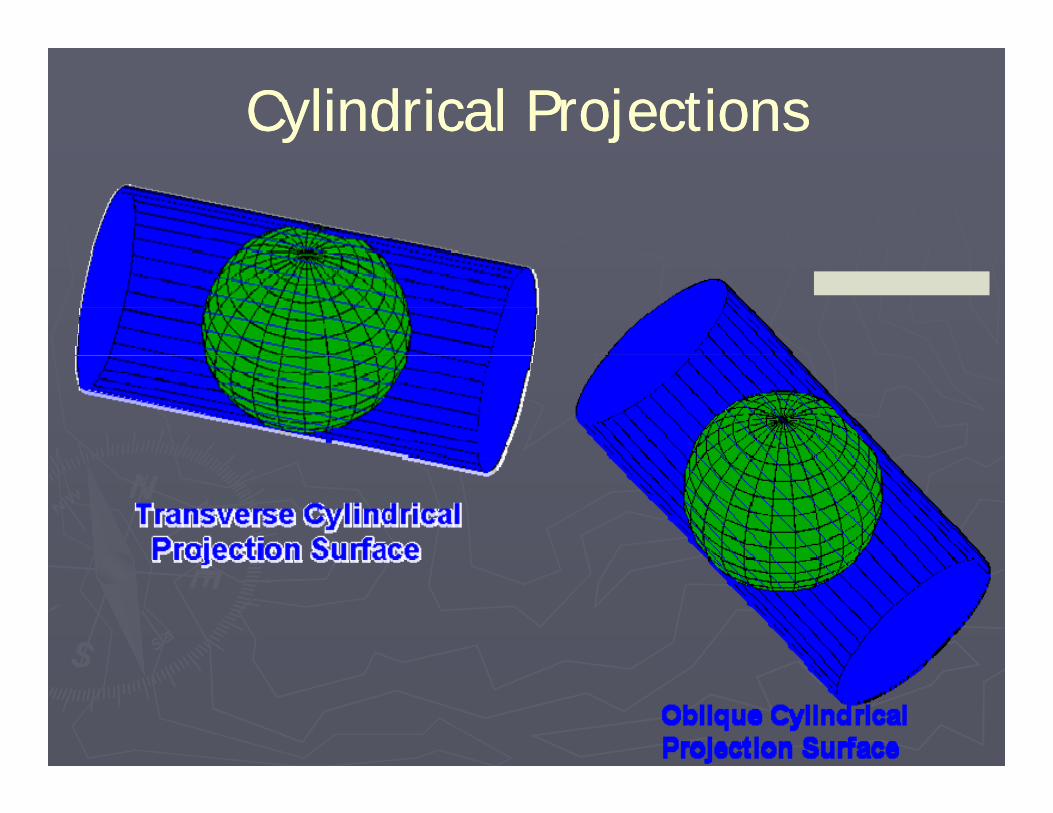
Planar ProjectionsPlanar ProjectionsPlanar ProjectionsPlanar Projections
Map Projection ParametersMap Projection ParametersMap Projection ParametersMap Projection Parameters
►►Map projection alone not enough to defineMap projection alone not enough to define►►Map projection alone not enough to define Map projection alone not enough to define projected coordinate system.projected coordinate system.
►►Must know values for parameters in order toMust know values for parameters in order to►►Must know values for parameters in order to Must know values for parameters in order to rere--project datasetproject datasetP t if i i d t iP t if i i d t i►►Parameters specify origin and customize a Parameters specify origin and customize a projection for specific area of interestprojection for specific area of interest

Linear ParametersLinear ParametersLinear ParametersLinear Parameters
►►False Easting and False NorthingFalse Easting and False Northing -- ensureensure►►False Easting and False Northing False Easting and False Northing ensure ensure x,yx,y values are positivevalues are positive
►►Scale FactorScale Factor Unitless value reduces overallUnitless value reduces overall►►Scale Factor Scale Factor –– Unitless value reduces overall Unitless value reduces overall distortiondistortion

Angular ParametersAngular ParametersAngular ParametersAngular Parameters
►►Azimuth Azimuth –– defines center of projectiondefines center of projectionp jp j►►Central Meridian Central Meridian –– Defines origin of the xDefines origin of the x--
coordinatescoordinates►► Longitude of OriginLongitude of Origin synonymous with Centralsynonymous with Central►► Longitude of Origin Longitude of Origin –– synonymous with Central synonymous with Central
MeridianMeridian►► Latitude of Origin Latitude of Origin –– defines origin of the ydefines origin of the y--gg g yg y
coordinatescoordinates►► Standard Parallel 1 and Standard Parallel 2 Standard Parallel 1 and Standard Parallel 2 –– used used
with conic projections to define latitude lineswith conic projections to define latitude lineswith conic projections to define latitude lines with conic projections to define latitude lines where scale is 1.where scale is 1.

Projections by Property Preserved:Projections by Property Preserved:Sh d ASh d AShape and AreaShape and Area
►► Conformal (orthomorphic)Conformal (orthomorphic)preserves preserves local local shape shape by using correct by using correct angles; angles; locallocal direction also direction also correct correct lat/long lines intersect at 90 degreeslat/long lines intersect at 90 degreeslat/long lines intersect at 90 degreeslat/long lines intersect at 90 degreesarea (and distance) is usually grossly distorted on at least part of the area (and distance) is usually grossly distorted on at least part of the mapmapno projection can preserve shape of larger areas everywhereno projection can preserve shape of larger areas everywhereuse for ‘presentations’; most large scale maps by USGS are conformaluse for ‘presentations’; most large scale maps by USGS are conformaluse for ‘presentations’; most large scale maps by USGS are conformaluse for ‘presentations’; most large scale maps by USGS are conformalexamples: mercator, stereographicexamples: mercator, stereographic
►► EqualEqual--Area (Equivalent or homolographic))Area (Equivalent or homolographic))areaarea of all displayed features is correctof all displayed features is correctp yp yshape, angle, scale or all three distorted to achieve equal areashape, angle, scale or all three distorted to achieve equal areacommonly used in GIS because of importance of area measurementscommonly used in GIS because of importance of area measurementsuse for thematic or distribution maps; use for thematic or distribution maps; examples: Alber’s conic Lambert’s azimuthalexamples: Alber’s conic Lambert’s azimuthalexamples: Alber s conic, Lambert s azimuthalexamples: Alber s conic, Lambert s azimuthal

Projections by Property Preserved:Projections by Property Preserved:Di t d Di tiDi t d Di tiDistance and DirectionDistance and Direction
►► EquidistantEquidistantpreserves distance (scale) between preserves distance (scale) between some some points or along some line(s)points or along some line(s)no no map is equidistant (i.e. has correct scale) map is equidistant (i.e. has correct scale) everywhereeverywhere on map (i.e. on map (i.e. betweenbetween allall points)points)between between allall points)points)distances distances truetrue along one or more lines (e.g. all parallels) or everywhere along one or more lines (e.g. all parallels) or everywhere from one pointfrom one pointgreat circles (shortest distance between two points) appear as straight linesgreat circles (shortest distance between two points) appear as straight linesimportant for long distance navigationimportant for long distance navigationimportant for long distance navigationimportant for long distance navigationexamples: sinusoidal, azimuthalexamples: sinusoidal, azimuthal
►► TrueTrue--directiondirectionprovides correct direction (bearing or azimuth) either locally or relative to provides correct direction (bearing or azimuth) either locally or relative to p ( g ) yp ( g ) ycentercenterrhumb lines (lines of constant direction) appear as straight linesrhumb lines (lines of constant direction) appear as straight linesimportant for navigationimportant for navigationsome may also be conformal equal area or equidistantsome may also be conformal equal area or equidistantsome may also be conformal, equal area, or equidistantsome may also be conformal, equal area, or equidistantexamples; mercator (for examples; mercator (for locallocal direction), azimuthal (relative to a center direction), azimuthal (relative to a center point)point)

Projections by Geometry:Projections by Geometry:Planar/Azimuthal/ZenithalPlanar/Azimuthal/Zenithal
►► map plane is tangent to (touches) globe at map plane is tangent to (touches) globe at single pointsingle point►► accuracy (shape, area) declines away from this pointaccuracy (shape, area) declines away from this point►► projection point (‘light source’) may beprojection point (‘light source’) may be
earth center (gnomic): all straight lines are great circlesearth center (gnomic): all straight lines are great circlesearth center (gnomic): all straight lines are great circlesearth center (gnomic): all straight lines are great circlesopposite side of globe (stereographic): conformal opposite side of globe (stereographic): conformal infinitely distant (orthographic): ‘looks like a globe’infinitely distant (orthographic): ‘looks like a globe’
►► good for polar mappings: parallels appear as circlesgood for polar mappings: parallels appear as circles►► good for polar mappings: parallels appear as circlesgood for polar mappings: parallels appear as circles►► also for navigation (laying out course): straight lines from also for navigation (laying out course): straight lines from
tangency point are all great circles (shortest distance on tangency point are all great circles (shortest distance on globe)globe)globe).globe).

Projections by Geometry:Projections by Geometry:C i lC i lConicalConical
►► map plane is tangent along a map plane is tangent along a line, line, most commonly a most commonly a parallel of latitude which is then the map’s parallel of latitude which is then the map’s standard standard parallelparallel
►► cone is cut along a meridian, and the meridian cone is cut along a meridian, and the meridian opposite the cut is the map’s opposite the cut is the map’s central meridiancentral meridian
►► alternatively, cone may intersect (alternatively, cone may intersect (secant tosecant to) globe, ) globe, y, y (y, y ( ) g ,) g ,thus there will be thus there will be two standard parallelstwo standard parallels
►► distortion increases as move away from the standard distortion increases as move away from the standard parallels (towards poles)parallels (towards poles)
►► good for mid latitude zones with eastgood for mid latitude zones with east--west extent west extent (e.g. the US), with polar area left off(e.g. the US), with polar area left off
►► examples: Alber’s Equal Area Conic, Lambert’s Conic examples: Alber’s Equal Area Conic, Lambert’s Conic p q ,p q ,ConformalConformal
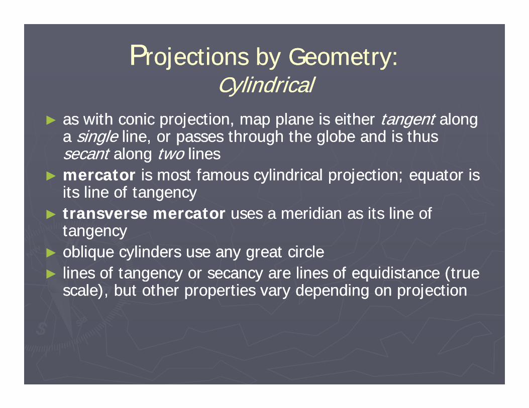
PProjections by Geometry:rojections by Geometry:CylindricalCylindrical
►► as with conic projection, map plane is either as with conic projection, map plane is either tangenttangent along along p j , p pp j , p p gg gga a single single line, or passes through the globe and is thus line, or passes through the globe and is thus secantsecant along along twotwo lines lines
►► mercatormercator is most famous cylindrical projection; equator isis most famous cylindrical projection; equator is►► mercatormercator is most famous cylindrical projection; equator is is most famous cylindrical projection; equator is its line of tangencyits line of tangency
►► transverse mercator transverse mercator uses a meridian as its line of uses a meridian as its line of tangencytangencytangencytangency
►► oblique cylinders use any great circleoblique cylinders use any great circle►► lines of tangency or secancy are lines of equidistance (true lines of tangency or secancy are lines of equidistance (true g y y q (g y y q (
scale), but other properties vary depending on projection scale), but other properties vary depending on projection

Commonly Encountered Map Projections Commonly Encountered Map Projections i Ti Tin Texasin Texas
►►Universal Transverse MecatorUniversal Transverse Mecator►►Universal Transverse MecatorUniversal Transverse Mecator►►State PlaneState Plane
T St t id M i S tT St t id M i S t►►Texas Statewide Mapping SystemTexas Statewide Mapping System

Universal Transverse Mercator (UTM)Universal Transverse Mercator (UTM)Universal Transverse Mercator (UTM)Universal Transverse Mercator (UTM)
13 14 15Midland
UTM in Texas:3 Conroe3 zones
102W 96W

State Plane Coordinate System (SPCS)State Plane Coordinate System (SPCS)State Plane Coordinate System (SPCS)State Plane Coordinate System (SPCS)
►► began in 1930s for public works projectsbegan in 1930s for public works projectsg p p jg p p j►► states divided into 1 or more zones (~130 total states divided into 1 or more zones (~130 total
for US)for US)►► Five zones for TexasFive zones for Texas►► Five zones for Texas Five zones for Texas ►►Different projections used:Different projections used:
transverse mercator (conformal) for States with large transverse mercator (conformal) for States with large a a o ( o o a ) o a a ga a o ( o o a ) o a a gN/S extentN/S extentLambert conformal conic for rest (incl. Texas)Lambert conformal conic for rest (incl. Texas)some states use both projections (NY, FL, AK)some states use both projections (NY, FL, AK)some states use both projections (NY, FL, AK)some states use both projections (NY, FL, AK)oblique mercator used for Alaska panhandleoblique mercator used for Alaska panhandle

Parameters for SPCS in TexasParameters for SPCS in TexasState & Zone Name Abbrev. Datum ZONE FIPSZONE
Texas, North TX_N 5326 4201Texas, North Central TX NC 5351 4202Texas, North Central TX_NC 5351 4202Texas, Central TX_C 5376 4203Texas, South Central TX_SC 5401 4204Texas, South TX_S 5426 4205
State Plane Zones - Lambert Conformal Conic Projection (parameters in degrees, minutes, seconds)Zone 1st Parallel 2nd Parallel C. Meridian Origin(Latitude) False Easting (m) False Northing(m)
NAD8334 39 00 36 11 00 101 30 00 34 00 00 200000 1000000TX_N 34 39 00 36 11 00 -101 30 00 34 00 00 200000 1000000
TX_NC 32 08 00 33 58 00 -98 30 00 31 40 00 600000 2000000TX_C 30 07 00 31 53 00 -100 20 00 29 40 00 700000 3000000TX_SC 28 23 00 30 17 00 -99 00 00 27 50 00 600000 4000000TX S 26 10 00 27 50 00 98 30 00 25 40 00 300000 5000000TX_S 26 10 00 27 50 00 -98 30 00 25 40 00 300000 5000000
TX_N 34 39 00 36 11 00 -101 30 00 34 00 00 609601.21920 0TX_NC 32 08 00 33 58 00 -97 30 00 31 40 00 609601.21920 0
NAD27
TX_C 30 07 00 31 53 00 -100 20 00 29 40 00 609601.21920 0TX_SC 28 23 00 30 17 00 -99 00 00 27 50 00 609601.21920 0TX_S 26 10 00 27 50 00 -98 30 00 25 40 00 609601.21920 0

Texas Statewide Mapping SystemTexas Statewide Mapping SystemTexas Statewide Mapping SystemTexas Statewide Mapping System
P j i L b C f l C i
NAD-27P j i L b C f l C i
NAD-83Projection: Lambert Conformal ConicEllipsoid: Clarke 1866Datum: North American 1927Longitude of Origin: W 100º ( 100)
Projection: Lambert Conformal ConicEllipsoid: GRS-80Datum: North American 1983Longitude of Origin: W 100º ( 100)Longitude of Origin: W 100º (-100)
Latitude of Origin: N 31º 10’ Standard Parallel # 1: N 27º 25’ Standard Parallel # 2: N 34º 55’
Longitude of Origin: W 100º (-100)Latitude of Origin: N 31º 10’ Standard Parallel # 1: N 27º 25’ Standard Parallel # 2: N 34º 55’Standard Parallel # 2: N 34 55
False Easting: 3,000,000 feetFalse Northing: 3,000,000 feetUnit of Measure: feet (international)
Standard Parallel # 2: N 34 55False Easting: 1,000,000 feetFalse Northing: 1,000,000 feetUnit of Measure: meters( )

Brazos County ProjectionsBrazos County ProjectionsBrazos County ProjectionsBrazos County Projections
►► City of Bryan, Brazos CountyCity of Bryan, Brazos Countyy y , yy y , yState Plane, TxCentral, NADState Plane, TxCentral, NAD--27, feet27, feet
►► City of College Station, BCSMPOCity of College Station, BCSMPOState Plane TxCentral NADState Plane TxCentral NAD--83 feet83 feetState Plane, TxCentral, NADState Plane, TxCentral, NAD 83, feet83, feet
►► TAMUTAMUState Plane, TxCentral, NADState Plane, TxCentral, NAD--83, meters83, meters
T D t t f T t tiT D t t f T t ti►► Texas Department of TransportationTexas Department of TransportationLambert Conformal (Shackelford), NADLambert Conformal (Shackelford), NAD--27/NAD27/NAD--83, feet/meters83, feet/meters
►► Texas Digital Orthometric QuadranglesTexas Digital Orthometric Quadranglesg Q gg Q gUTM, Zone 14, NADUTM, Zone 14, NAD--83, meters 83, meters

Choosing an Appropriate ProjectionChoosing an Appropriate Projection
►► You must consider the map’s You must consider the map’s subject subject jjpurpose purpose
►► The subjects area’s The subjects area’s sizesizesize size shape shape location location
►► also the audience and general attractivenessalso the audience and general attractiveness►► also, the audience and general attractiveness, also, the audience and general attractiveness, size and shape of page, appearance of the size and shape of page, appearance of the graticulegraticule

Choosing an Appropriate ProjectionChoosing an Appropriate ProjectionChoosing an Appropriate ProjectionChoosing an Appropriate Projectionsubject and map purposesubject and map purposej p p pj p p p►► for distribution maps, use equalfor distribution maps, use equal--area area ►► for navigation, use projections that show azimuths or for navigation, use projections that show azimuths or
angles properlyangles properlyangles properlyangles properlysize and shape of areasize and shape of area►► Some projections are better suited to eastSome projections are better suited to east--west extent, west extent,
others to northothers to north--south south ►► for small areas (largefor small areas (large--scale), projection is relatively scale), projection is relatively
unimportant, but for large areas it is VERY IMPORTANTunimportant, but for large areas it is VERY IMPORTANTunimportant, but for large areas it is VERY IMPORTANT unimportant, but for large areas it is VERY IMPORTANT ►► interrupted or uninterrupted? Water, land, or both?interrupted or uninterrupted? Water, land, or both?

Choosing an Appropriate ProjectionChoosing an Appropriate Projectionlocationlocation►► Conic projections for midConic projections for mid--latitudes, especially areas latitudes, especially areas
hh h hh h hhwith greater eastwith greater east--west extent than northwest extent than north--south south ►► An oblique conic or polyconic is suitable for midAn oblique conic or polyconic is suitable for mid--
latitude northlatitude north--south areas south areas ►► Cylindrical for equatorial regions Cylindrical for equatorial regions ►► azimuthal (planar) for polesazimuthal (planar) for polesBBBecause...Because...►► Cylindricals are true at the equator and distortion Cylindricals are true at the equator and distortion
increases toward the poles increases toward the poles pp►► conics are true along some parallel between the poles conics are true along some parallel between the poles
and equator and equator ►► Azimuthals are true only at their center point butAzimuthals are true only at their center point but►► Azimuthals are true only at their center point, but Azimuthals are true only at their center point, but
distortion is generally worst at the edgesdistortion is generally worst at the edges

Summary on Projections an Summary on Projections an C di t tC di t tCoordinate systemsCoordinate systems
►► GCS uses 3D spherical surface to define locationsGCS uses 3D spherical surface to define locations►► Points referenced by latitude and longitudePoints referenced by latitude and longitude
Latitude: Parallels; equator is originLatitude: Parallels; equator is originLongitude: Meridians; Prime Meridian is originLongitude: Meridians; Prime Meridian is origin
►► Spheroids more accurately depict earth than sphereSpheroids more accurately depict earth than sphere►► Datum defines position of spheroid relative to center of the Datum defines position of spheroid relative to center of the
earthearth►► Datum defines origin and orientation of lat/long linesDatum defines origin and orientation of lat/long lines►► Map projection transforms 3D surface to 2DMap projection transforms 3D surface to 2D►► Map projections distort shape area distance or directionMap projections distort shape area distance or direction►► Map projections distort shape, area, distance or direction Map projections distort shape, area, distance or direction
of dataof data

Conceptual Summary of Projections Conceptual Summary of Projections an Coordinate systems an Coordinate systems a Coo d ate syste sa Coo d ate syste s
X-Y coordinates--derived via projection from lat/long
t iti 2 D fl t
Lines of latitude and Longitude
--represent position on 2-D flat map surface
Spheroid: “math model
--are drawn on the spheroid--establish position on 3-D spheroidThis guy’s latitude and
longitude (and elevation) diff d di Spheroid: math model
representing geoid”Spheroid+tiepoint=datum
differ depending on
spheroid used.
L d S f
Geoid: --line of equal gravity
Elevation may be: --above geoid Land Surface q g y
--mean sea level with no wind or tides
above geoid (traditional surveying)--above spheroid (GPS)

ReferencesReferencesReferencesReferences►► Clark, K.C. 1997. Clark, K.C. 1997. Getting Started with Getting Started with
Geographic Information Systems.Geographic Information Systems.Geographic Information Systems.Geographic Information Systems.►► Davis, B.E. 1996. Davis, B.E. 1996. GIS: A Visual Approach.GIS: A Visual Approach.►► DeMers, M.N. 1997. DeMers, M.N. 1997. Fundamentals of Geographic Fundamentals of Geographic
Info mation S stemsInfo mation S stemsInformation Systems.Information Systems.►► http://www.esri.com/ 24http://www.esri.com/ 24--MayMay--20002000►► http://www.colorado.Edu/geography/gcraft/nhttp://www.colorado.Edu/geography/gcraft/np // /g g p y/g /p // /g g p y/g /
otes/mapproj/mapproj_f.htmlotes/mapproj/mapproj_f.html►► Mitchell, A. 1999. Mitchell, A. 1999. The ESRI Guide to GIS The ESRI Guide to GIS
Analysis Vol 1: Geographic Patterns andAnalysis Vol 1: Geographic Patterns andAnalysis. Vol. 1: Geographic Patterns and Analysis. Vol. 1: Geographic Patterns and Relationships.Relationships.
►► Theobald, DM. 1999. Theobald, DM. 1999. GIS Concepts & ArcView GIS Concepts & ArcView Methods.Methods.
►► Zeiler, Michael. 1999. Zeiler, Michael. 1999. Modeling Our World: The Modeling Our World: The ESRI guide to Geodatabase Design.ESRI guide to Geodatabase Design.