Embed Size (px)
Citation preview
1
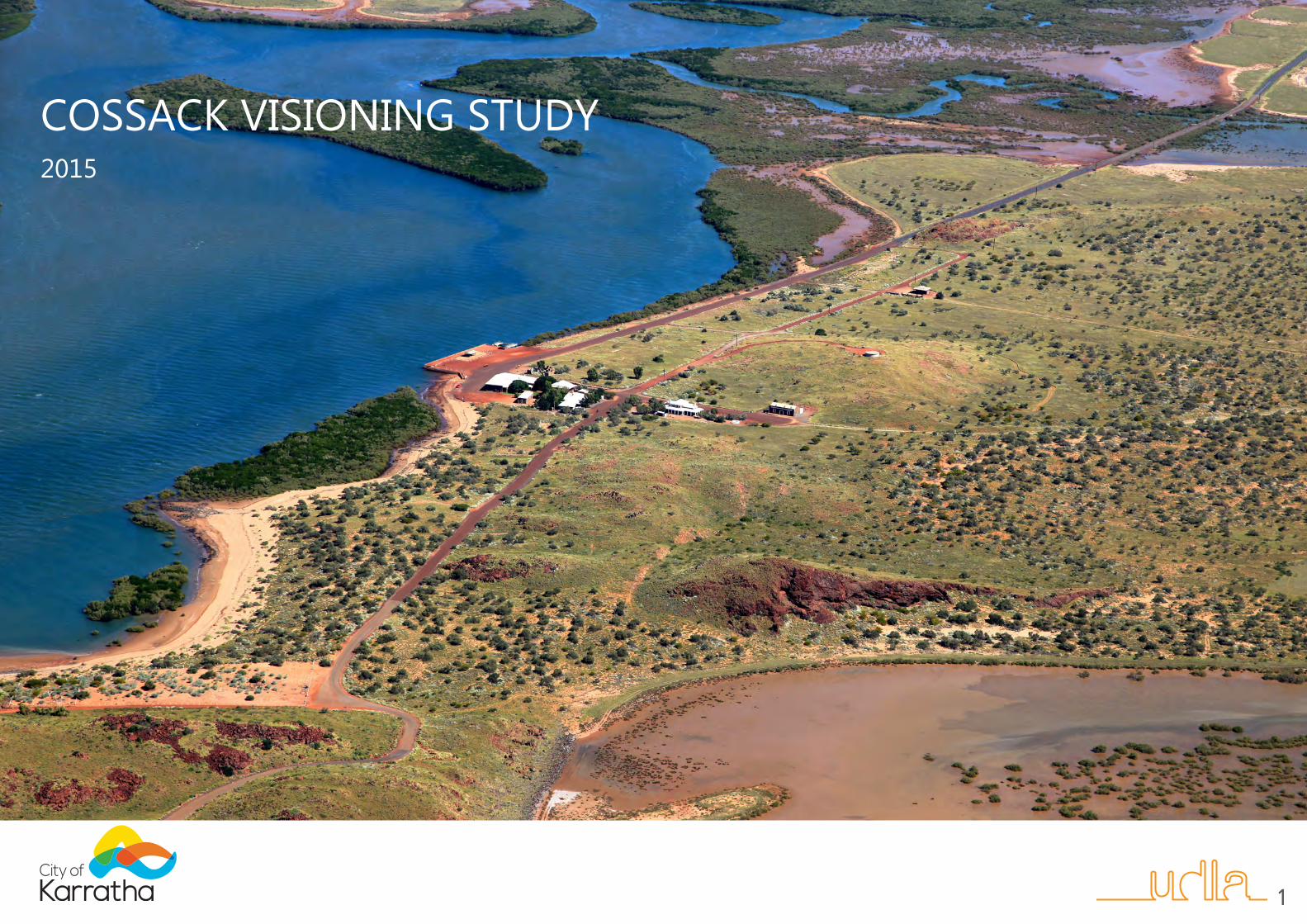
COSSACK VISIONING STUDY2015
1

2
CONTENTSSummary report: Purpose, Background and Vision 3 Summary report: Recommendation, Precinct Plan, References 4
Cossack Visioning Study 5

3
PURPOSEThe City of Karratha commissioned UDLA to undertake a visioning study to provide a framework and visual aids to stimulate consideration of suitable future development in the town of Cossack.The City of Karratha is undertaking a number of strategic planning activities to ensure that the Shire is able to adequately accommodate and service population growth.The historic town of Cossack is situated between Roebourne and Point Samson and could potentially become a higher level tourism destination then at the current time and support diversification of the regional economy.The town was largely abandoned in the early 1900’s and is currently used for low-key tourist site seeing, local fishing, accommodation and functions. Many of Cossack’s buildings are National Trust listed. Whilst it is not envisaged that Cossack will support future population growth, development that is sensitive to Cossack’s unique attributes is necessary to increase visitor and event opportunities, which in turn will provide ongoing funds to preserve existing town infrastructure.This visioning study will form the basis of future masterplanning, detailed design and implementation exercises for Cossack.
BACKGROUNDThe future direction for Cossack has been considered at State and Local Government level for many years. The Shire has been the managing authority of Cossack since a 21 year lease agreement with the State was entered into in 1996. Numerous investigations and resulting reports into the future of Cossack have been developed over the years, however no consensus has been developed as to which components of the various investigations should be progressed. As a result, the status quo, of ‘care and maintenance’ of the town and Jarman Island has continued, with minimal funds available to the Shire to properly maintain such an historical asset. The Cossack Visioning Study was undertaken to develop options for a future vision for Cossack that would ensure the long term maintenance of the existing historical value and physical attributes of the town, whilst providing a tourist draw-card for the region that is economically viable and sustainable. The Visioning Study initially undertook a constraints analysis and looked at the potential opportunities of Cossack’s location. When undertaking the constraints analysis each of the physical constraints (flooding, storm surge, topography, existing known archaeological sites) along with a view shed analysis of the site was mapped and layered. This produced imagery that determined the areas within the Cossack townsite that were considered appropriate for future development and would not have a significant visual impact on the existing historical centre of Cossack, the old school site location and on the entry into Cossack.In addition evidential analysis of all relevant earlier reports relating to management of the town of Cossack was undertaken and these documents are referenced on page 4 of this document. From this analysis and with guidance from the Cossack Advisory Group (CAG), the study developed three options for the town and a vision statement. The CAG supported Cossack as a place that should encompass the following: heritage town, tourism destination, eco-village style, sustainable, self sufficient in terms of most services, low impact, sensitive design, low visual impact and economically viable. Further to this, it was hoped the study may provide within the developed options a potential avenue to assist with existing land tenure issues at Cossack that would allow for the progression of a vision for Cossack. Three options were developed following the constraints and opportunities analysis:1. The first concept explores the idea of a concealed development that is
hidden from the key viewing area that define Cossacks current visual character.
2. The second aims to re-instate the character of the past and is focused on the creation of shack or cabin like accommodation options close to the centre of town to re-create a lively town centre that is in keeping with the past.
3. The third concept is a combination of the first two with multiple accommodation options both shack like cabins that reinstate the character of the past in the town centre and concealed camping and high end glamour camping or “Glamping”.
All concepts adhere to specific defining principles that assist in guiding development to achieve the desired character in a practical and site suitable way.
VISIONEXPERIENCE COSSACK….
REFLECT ON THE PAST__APPRECIATE THE PRESENT__CELEBRATE PILBARA’S FUTURE
Cossack is a Pilbara treasure, where the signposts of time guide reflection of the past, appreciation of the present and celebration of the future. This experience will be broadly appealing and sophisticated. The development of Cossack will aim to achieve an environmentally sensitive, socially enriching, and economically sustainable balance for the historic town site.
REFLECT ON THE PAST Cossack has a rich and diverse past that maintains a strong presence. The European heritage is represented with the remnant built structures from the towns pioneering past. Aboriginal cultural heritage is strong in Cossack and surrounding lands and the Ngarlama people are the traditional custodians of the land. Cossack contains identified shell midden sites, rock art, and other evidence of the continued cultural association between Aboriginal people and this unique landscape. The environment represents a vaster time scale and the significant geology that has supplied Pilbara’s recent wealth provides a key feature in the local landscape character in the form of rocky outcrops and hills. The Pilbara landscape is amongst the oldest in the world with stone formations up to 2 billion years old.
APPRECIATE THE PRESENTCossack has the potential to provide high quality amenity to visitors as a day trip or short stay holiday location. It offers the opportunity to depart from daily life and separate from the urban and industrial landscape. When combined with high quality facilities and accommodation an enjoyable, relaxing and potentially nourishing and invigorating experience is possible.
CELEBRATE PILBARA’S FUTURECossack can be a place of celebration, a celebration of the Pilbara’s future as a sophisticated, global and significant region. The demand for suitable high quality amenity will increase with the increase in permanent population numbers of the surrounding towns. Cossack has the potential to assist in fulfilling this need and showcase the unique Pilbara natural environment and heritage.
COSSACK VISIONING SUMMARY REPORT
4
RECOMMENDATIONThe Cossack Advisory Group (CAG) at it’s meeting of 12 June 2014 considered all three options presented by the Visioning Study and resolved to support the Option 3 – Combined Option. CAG considers that this is the best option for potential development at Cossack and aligns with the developed vision for Cossack, whilst also presenting a satisfactory option to potentially assist, with other State Government agencies, methods for addressing matters pertaining to land ownership at Cossack.
CAG recognises detailed investigations into the form of the combination of accommodation options would be required and that close consultation with the Department of Lands, Department of Planning, Heritage Council WA for the future development of Cossack and progression of any land tenure matters is required. It was also recognised that suitable design guidelines should be developed to ensure any future structures be in line with the vision for Cossack.
The CAG supports the Vision Statement as presented above and seeks Council support for both the Vision Statement for Cossack and the ‘Combined Option’ so that these can be used to initiate discussions with the relevant State level stakeholders.
PRECINCT PLAN Option 3 - “The Combined option”, as recommended by the CAG has been delineated into precincts to illustrate the potential for future development to be conducted in separable portions.
KEY REFERENCESDepartment of Planning (2010) “Cossack Development Assessment Report –Draft”. Department of Planning, Perth, WA.
Department of Transport (2010) “Cossack – Coastal Vulnerability Assessment – Draft” Department of Transport, Coastal Infrastructure, Coastal Engineering Group, Fremantle, WA.
Heritage Council for Western Australia (1996) “Cossack – A Policy for its Conservation” prepared by the Heritage Council of Western Australia with assistance from the Australian Heritage Commission.
MiIlroy, J (1990) “Recommendations & Management – Cossack The Productive Edge “The Future Conservation & Development of Cossack - Draft” ( The Productive Edge).
Nayton, G (2005) “Cossack Sustainable Development – An Alternative Strategy” Prepared by Gaye Nayton B.Sc (Hons), AACAI.
Palassis Architects (2000) “Cossack – Zones of Significance and Development Potential – Working Draft” prepared for the Heritage Council of Western Australia.
Palassis Architects (2007) “Draft Master Plan” Prepared by a Palassis Architects led project team as a joint project for the Department of Housing and Works, the Shire of Roebourne and the Heritage Council of WA.
Peter Farr Consultants (2001) “Historic Town of Cossack Sustainable Management Study - 2001 and beyond” prepared for the Cossack Steering Committee.
Shire of Roebourne “Cossack Town Planning Management Plan – Draft for Public Comment”
State Planning Commission (1989) “Cossack Conservation and Management Plan –Cossack Task Force Second Report” Prepared for the Cossack Task Force.
Precinct delineation plan
Existing building
Archaeological remain
Butcher’s Inlet
Townsite Development Zone
Special Design Zone 1
Special Design Zone 2
Special Design Zone 3
5
COSSACK VISIONING STUDY
6
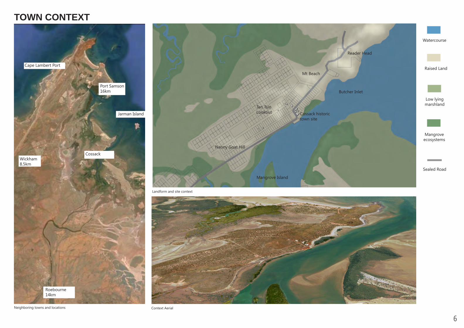
Roebourne14km
Wickham8.5km
Cossack
Port Samson16km
Jarman Island
Cape Lambert Port
Neighboring towns and locations Context Aerial
TOWN CONTEXT
Landform and site context
Watercourse
Raised Land
Low lying marshland
Mangrove ecosystems
Sealed Road
Reader Head
Nanny Goat Hill
Mt Beach
Butcher Inlet
Ten Tsin Lookout
Mangrove Island
Cossack historic town site
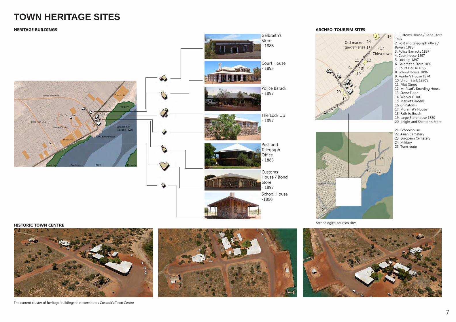
7The current cluster of heritage buildings that constitutes Cossack’s Town Centre
ARCHEO-TOURISM SITES
Archeological tourism sites
1. Customs House / Bond Store 18972. Post and telegraph office / Bakery 18853. Police Barracks 18974. Cook house 18975. Lock up 18976. Galbraith’s Store 18917. Court House 18958. School House 18969. Pearler’s House 187410. Union Bank 1890’s11. Pilot Street12. Mr Pead’s Boarding House13. Stone Floor14. Workers’ Hut15. Market Gardens 16. Chinatown17. Muramat’s House18. Path to Beach 19. Large Storehouse 188020. Knight and Shenton’s Store
21. Schoolhouse22. Asian Cemetery23. European Cemetery24. Military25. Tram route
HERITAGE BUILDINGSGalbraith’s Store- 1888
Court House- 1895
Police Barack - 1897
The Lock Up- 1897
Post and Telegraph Office- 1885 Customs House / Bond Store - 1897School House-1896
Old market garden sites
2
1
13
20
19
3 45
7
6 910
18
11 12
17
1415 16
Perse
rveran
ce St
reet China town
Cossack Road
Pearl Road
21
2223
24
25
HISTORIC TOWN CENTRE
TOWN HERITAGE SITES
8
1 in 100 Year ARI PSWL and wave run up (6.5m AHD)
Entrance Viewshed - Analysis from Cossack Road entrance at intersection with track to schoolhouse
Schoolhouse Viewshed - Analysis of the view shed from the Schoolhouse building
Town Centre Viewshed - Analysis from the corner of Perseverance Street and Pearl Road
Combined Viewsheds from the key view locations
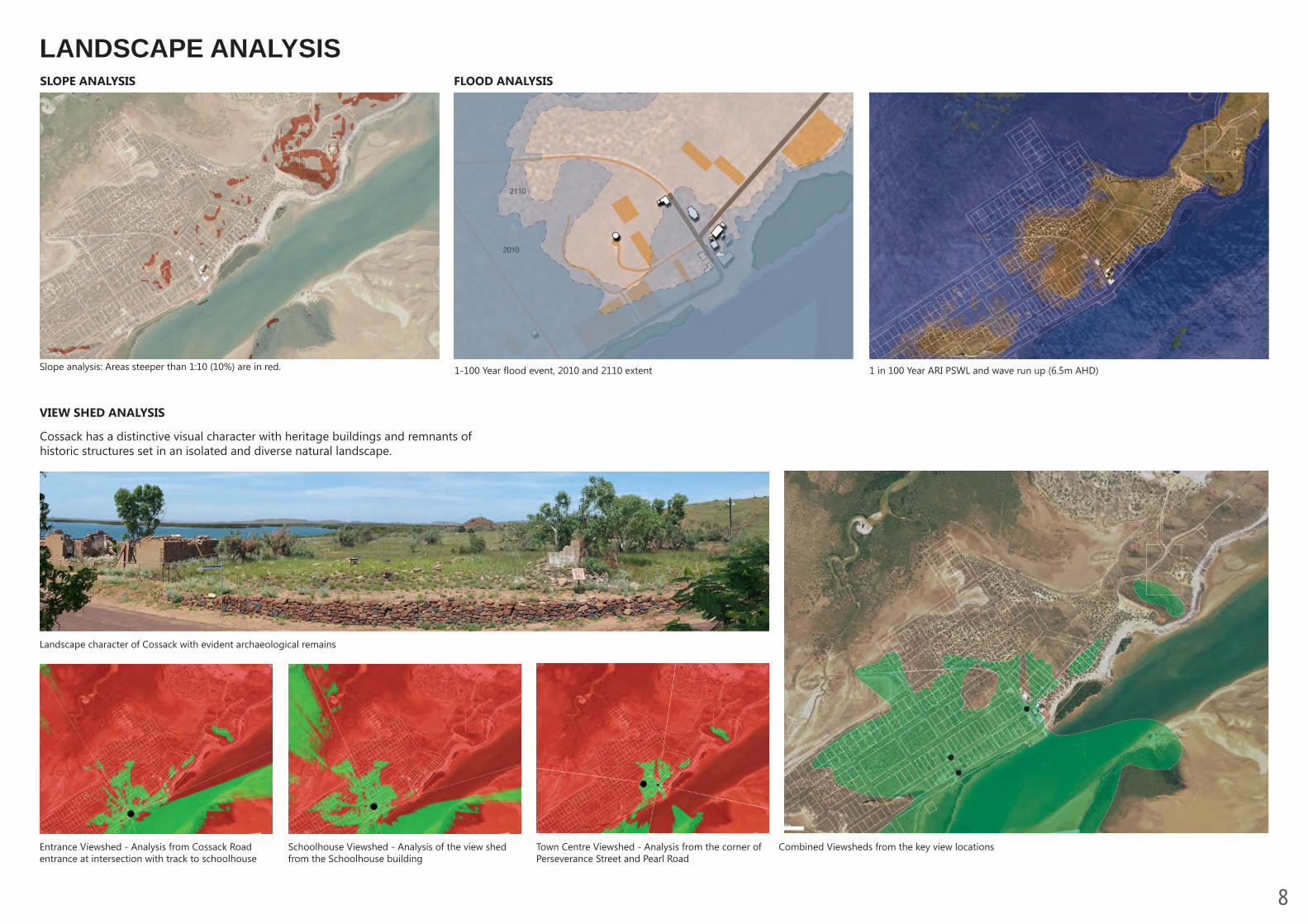
Slope analysis: Areas steeper than 1:10 (10%) are in red.
VIEW SHED ANALYSIS
Cossack has a distinctive visual character with heritage buildings and remnants of historic structures set in an isolated and diverse natural landscape.
SLOPE ANALYSIS FLOOD ANALYSIS
Landscape character of Cossack with evident archaeological remains
2010
2110
1-100 Year flood event, 2010 and 2110 extent
LANDSCAPE ANALYSIS
9
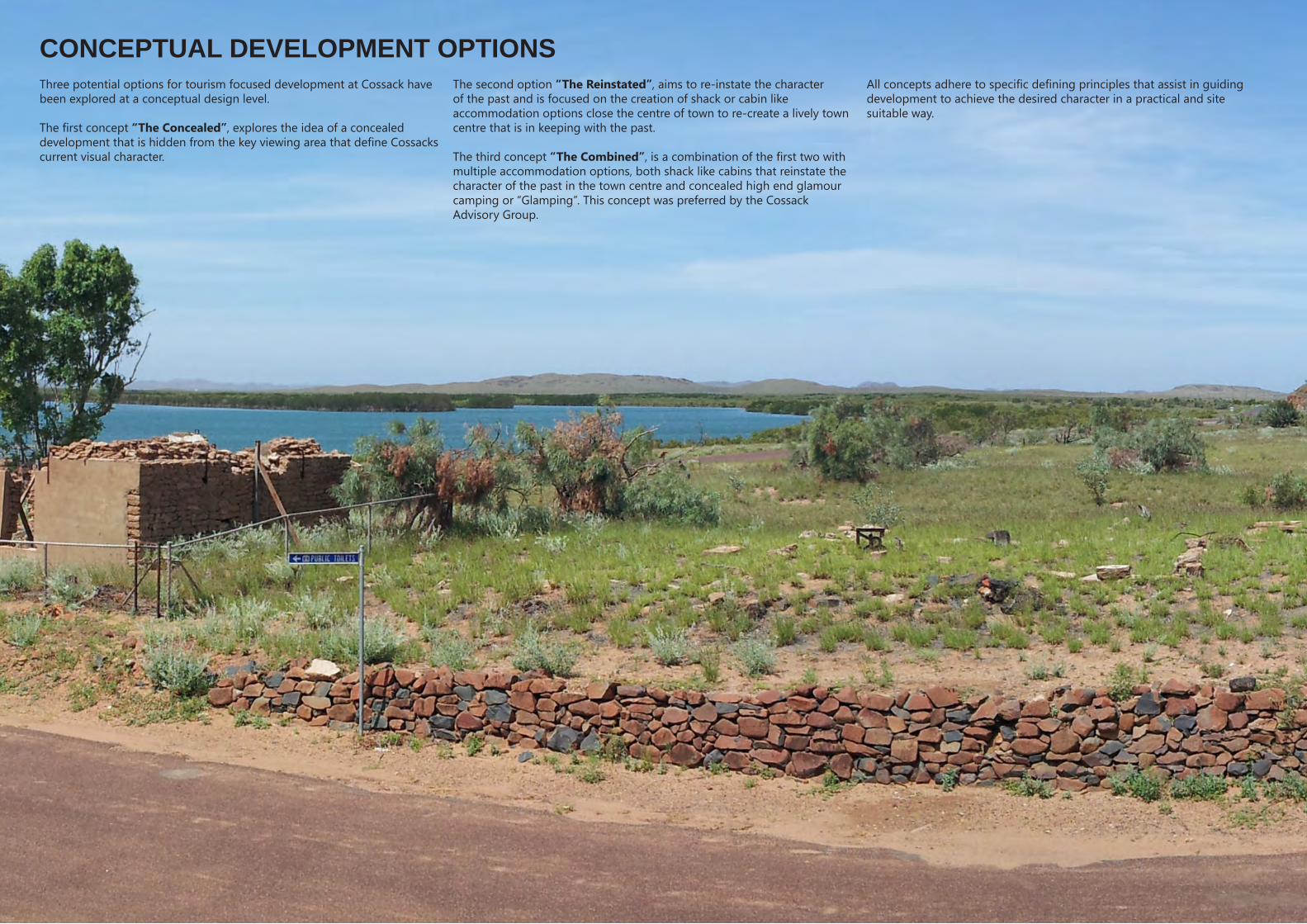
The second option “The Reinstated”, aims to re-instate the character of the past and is focused on the creation of shack or cabin like accommodation options close the centre of town to re-create a lively town centre that is in keeping with the past.
The third concept “The Combined”, is a combination of the first two with multiple accommodation options, both shack like cabins that reinstate the character of the past in the town centre and concealed high end glamour camping or “Glamping”. This concept was preferred by the Cossack Advisory Group.
All concepts adhere to specific defining principles that assist in guiding development to achieve the desired character in a practical and site suitable way.
Three potential options for tourism focused development at Cossack have been explored at a conceptual design level.
The first concept “The Concealed”, explores the idea of a concealed development that is hidden from the key viewing area that define Cossacks current visual character.
CONCEPTUAL DEVELOPMENT OPTIONS
10
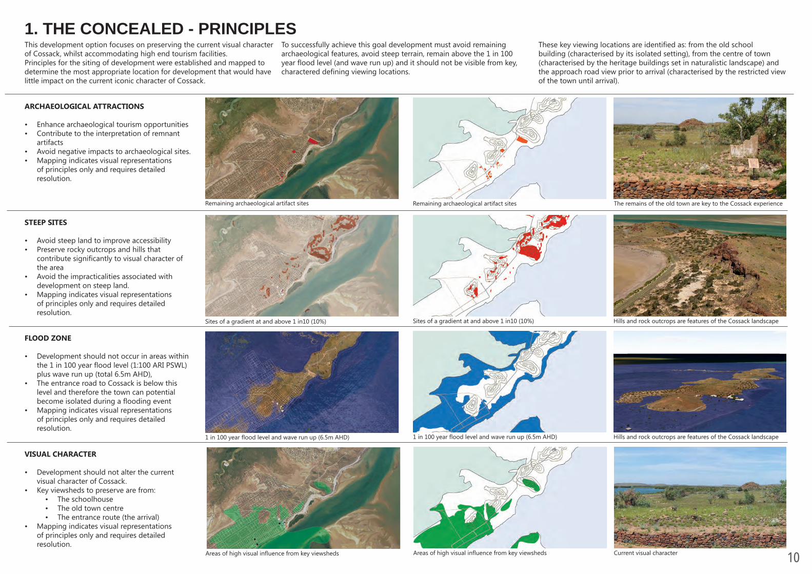
1. THE CONCEALED - PRINCIPLES
ARCHAEOLOGICAL ATTRACTIONS
• Enhance archaeological tourism opportunities • Contribute to the interpretation of remnant
artifacts • Avoid negative impacts to archaeological sites.• Mapping indicates visual representations
of principles only and requires detailed resolution.
STEEP SITES
• Avoid steep land to improve accessibility• Preserve rocky outcrops and hills that
contribute significantly to visual character of the area
• Avoid the impracticalities associated with development on steep land.
• Mapping indicates visual representations of principles only and requires detailed resolution.
VISUAL CHARACTER
• Development should not alter the current visual character of Cossack.
• Key viewsheds to preserve are from:• The schoolhouse • The old town centre • The entrance route (the arrival)
• Mapping indicates visual representations of principles only and requires detailed resolution.
FLOOD ZONE
• Development should not occur in areas within the 1 in 100 year flood level (1:100 ARI PSWL) plus wave run up (total 6.5m AHD),
• The entrance road to Cossack is below this level and therefore the town can potential become isolated during a flooding event
• Mapping indicates visual representations of principles only and requires detailed resolution.
Remaining archaeological artifact sites
Sites of a gradient at and above 1 in10 (10%)
1 in 100 year flood level and wave run up (6.5m AHD)
Areas of high visual influence from key viewsheds
Remaining archaeological artifact sites
Sites of a gradient at and above 1 in10 (10%)
1 in 100 year flood level and wave run up (6.5m AHD)
Areas of high visual influence from key viewsheds
The remains of the old town are key to the Cossack experience
Hills and rock outcrops are features of the Cossack landscape
Hills and rock outcrops are features of the Cossack landscape
Current visual character
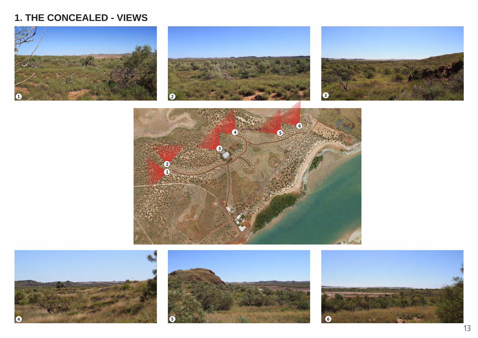
To successfully achieve this goal development must avoid remaining archaeological features, avoid steep terrain, remain above the 1 in 100 year flood level (and wave run up) and it should not be visible from key, charactered defining viewing locations.
These key viewing locations are identified as: from the old school building (characterised by its isolated setting), from the centre of town (characterised by the heritage buildings set in naturalistic landscape) and the approach road view prior to arrival (characterised by the restricted view of the town until arrival).
This development option focuses on preserving the current visual character of Cossack, whilst accommodating high end tourism facilities.Principles for the siting of development were established and mapped to determine the most appropriate location for development that would have little impact on the current iconic character of Cossack.

11
1. THE CONCEALED - PLAN
Social camp fire example - Martins Tank, Yalgorup National Park
Eco-resort style tourist accommodation with “Glamping” - Karijini Eco Retreat, Karijini National Park
High end camp sites “Glamping”
Swimming pool
Main reception building with restau-rant and bar
Unsealed access roads
Social camp fire area
Entrance to Eco-Resort from Pearl Road
Alternative entrance from Persever-ance Street
Extent of land available for develop-ment following design principles
Designated land available for development after mapping of principles
Combined principles mapping Archaeological Attractions Flood ZoneSteep Sites Visual character influence
YIELD: - 64 GLAMPING SITES
The access to the resort is proposed as unsealed vehicle tracks that connect the individual tents to the main reception / restaurant / bar building that also features a swimming pool.
This development option proposes an eco-style resort with “glamping” (deluxe tents as shown in pictures below) as visitor accommodation. The proposed development site lies in the area of land that remains following exclusion of much of the site by adherence to the guiding principles.
12
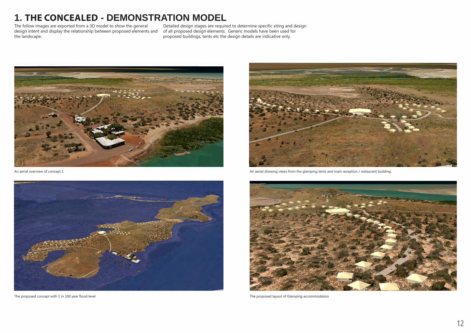
1. THE CONCEALED - DEMONSTRATION MODEL
The proposed concept with 1 in 100 year flood level
The proposed layout of Glamping accommodation
An aerial overview of concept 1
An aerial showing views from the glamping tents and main reception / restaurant building.
Detailed design stages are required to determine specific siting and design of all proposed design elements. Generic models have been used for proposed buildings, tents etc the design details are indicative only.
The follow images are exported from a 3D model to show the general design intent and display the relationship between proposed elements and the landscape.
13
1. THE CONCEALED - VIEWS
1
1
2
2
4 5 6
3
3
4 56
14
2. THE REINSTATED - PRINCIPLES
ARCHAEOLOGICAL ATTRACTIONS
• Enhance archaeological tourism opportunities • Contribute to the interpretation of remnant
artifacts • Avoid negative impacts to archaeological sites.• Mapping indicates visual representations
of principles only and requires detailed resolution.
STEEP SITES
• Avoid steep land to improve accessibility• Preserve rocky outcrops and hills that
contribute significantly to visual character of the area
• Avoid the impracticalities associated with development on steep land.
• Mapping indicates visual representations of principles only and requires detailed resolution.
FLOOD ZONE
• Development should not occur in areas within the 1 in 100 year flood level (1:100 ARI PSWL) plus wave run up (total 6.5m AHD),
• The entrance road to Cossack is below this level and therefore the town can potential become isolated during a flooding event
• Mapping indicates visual representations of principles only and requires detailed resolution.
Remaining archaeological artifact sites
Sites of a gradient at and above 1 in10 (10%)
1 in 100 year flood level and wave run up
Remaining archaeological artifact sites
Sites of a gradient at and above 1 in10 (10%)
1 in 100 year flood level and wave run up (6.5m AHD)
The remains of the old town are key to the Cossack experience
Hills and rock outcrops are features of the Cossack landscape
Hills and rock outcrops are features of the Cossack landscape
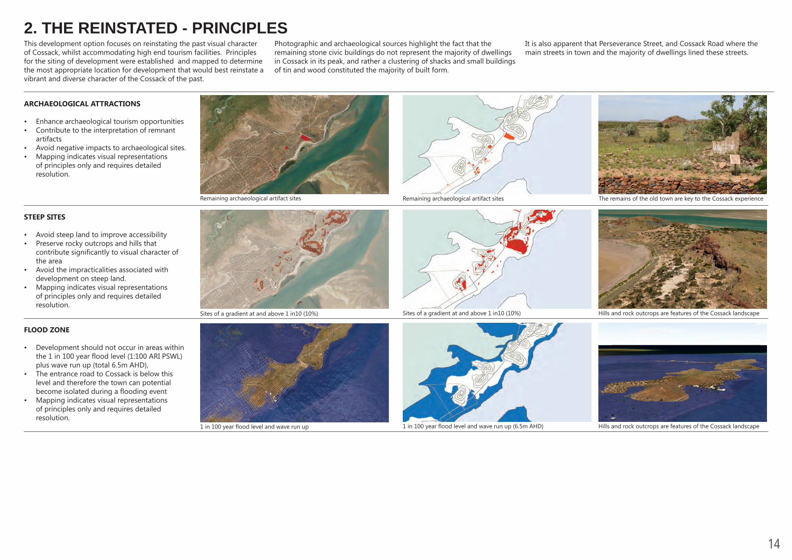
Photographic and archaeological sources highlight the fact that the remaining stone civic buildings do not represent the majority of dwellings in Cossack in its peak, and rather a clustering of shacks and small buildings of tin and wood constituted the majority of built form.
It is also apparent that Perseverance Street, and Cossack Road where the main streets in town and the majority of dwellings lined these streets.
This development option focuses on reinstating the past visual character of Cossack, whilst accommodating high end tourism facilities. Principles for the siting of development were established and mapped to determine the most appropriate location for development that would best reinstate a vibrant and diverse character of the Cossack of the past.
15
2. THE REINSTATED- PLAN
Extent of land available for develop-ment following design principles
China Town area with deluxe shack accommodation overlooking Butchers
inlet
Examples of contemporary architecturally designed “shacks” A contemporary portable “shack”
Unsealed access roads
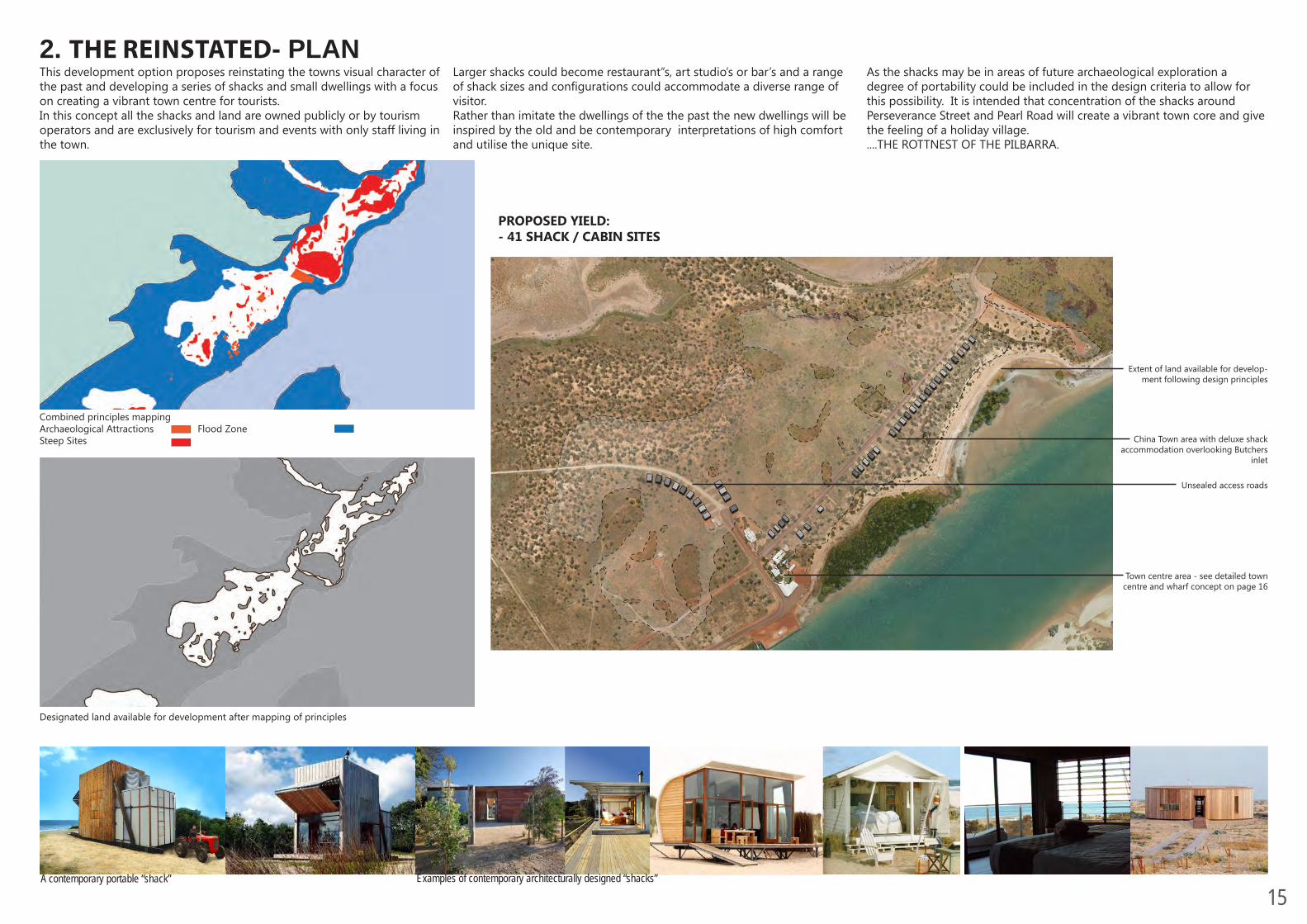
PROPOSED YIELD: - 41 SHACK / CABIN SITES
Town centre area - see detailed town centre and wharf concept on page 16
Designated land available for development after mapping of principles
Combined principles mapping Archaeological Attractions Flood ZoneSteep Sites
Larger shacks could become restaurant”s, art studio’s or bar’s and a range of shack sizes and configurations could accommodate a diverse range of visitor. Rather than imitate the dwellings of the the past the new dwellings will be inspired by the old and be contemporary interpretations of high comfort and utilise the unique site.
As the shacks may be in areas of future archaeological exploration a degree of portability could be included in the design criteria to allow for this possibility. It is intended that concentration of the shacks around Perseverance Street and Pearl Road will create a vibrant town core and give the feeling of a holiday village. ....THE ROTTNEST OF THE PILBARRA.
This development option proposes reinstating the towns visual character of the past and developing a series of shacks and small dwellings with a focus on creating a vibrant town centre for tourists. In this concept all the shacks and land are owned publicly or by tourism operators and are exclusively for tourism and events with only staff living in the town.

16
2. OLD COSSACK - BUILT FORM - PAST AND POTENTIAL
Built form in Cossack - 1897 source: City of Karratha ID: 2004.183a-cContemporary shack / cabin designs
ID: 2004.178a-bCOSSACK C1890'S
C:\Program Files\ISTechnology\MosaicPlus\Images\Items- Photos\Tien-tsin.jpgFile:
Item Dates: 1897View of The Strand showing residential housing and businesses of Cossack. Tramline and tramshed in foreground. The house at the bottom right hand side belonged to Andrew Stonehouse Thompson, a shipwright which burnt down 27/11/1900. Bondstore, telegraph building, cossack police quarters, Mrs Pead's boarding house in background.
Model of a small shack / cabin used in the conceptual 3D model.
ID: 2004.183a-cCOSSACK
C:\Program Files\ISTechnology\MosaicPlus\Images\Items- Photos\Cossack town16.jpg
File:
Item Dates: 1897Photo is an enlargement of 2004.178 but in doing so it has cut off to the right the view of the road into town and the wharf. Of the house in bottom right hand corner of 2004.178 only the shed is seen in this photo. Not as much is lost on to the left.
Built form in Cossack - 1897 source: City of Karratha ID: 2004.178a-b
Other potential Architectural design parameters could include:• On-site biological sewage• Cyclone resistance • Mobility (particularly over land with potential archeological
significance)
The original built form was diverse, and potential exists for a diverse array of site specific designs that adhere to the design parameters. Architecture competitions could be conducted to utilise the potential for these small designs to profile the skill of local architects. Despite the intention for diversity the model right has been used to insert into the conceptual 3D model.
An architectural study would be required to determine the most appropriate parameters to guide the development and design of the new shacks. These parameters could mandate elements from the built form of the past such as:
• Building materials• Building footprint• Absence of fencing• Lot size• Setback

17
2. THE REINSTATED - DEMONSTRATION MODEL
The proposed concept with 1 in 100 year flood level
The main town centre with proposed shacks
An aerial overview of concept 2 An aerial showing views from the shacks along Perseverance Street.
Detailed design stages are required to determine specific siting and design of all proposed design elements. Generic models have been used for proposed buildings, tents etc the design details are indicative only.
The follow images are exported from a 3D model to show the general design intent and display the relationship between proposed elements and the landscape.
18
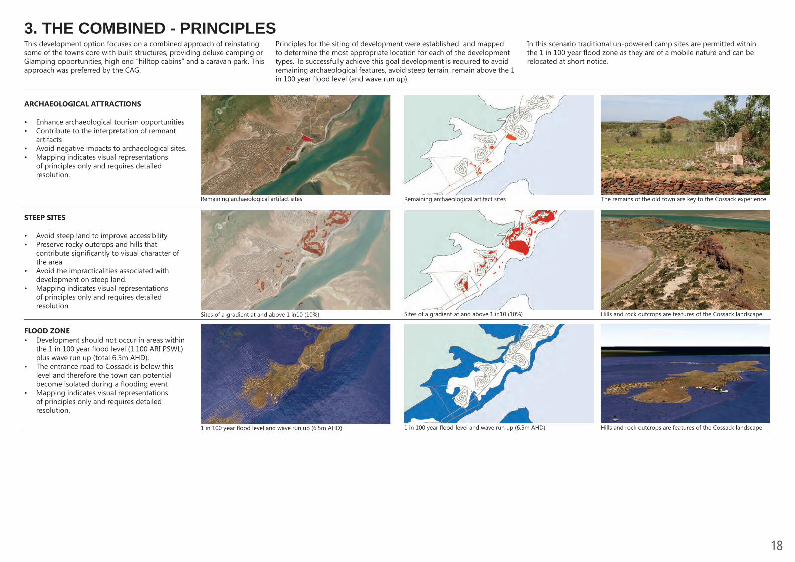
3. THE COMBINED - PRINCIPLES
ARCHAEOLOGICAL ATTRACTIONS
• Enhance archaeological tourism opportunities • Contribute to the interpretation of remnant
artifacts • Avoid negative impacts to archaeological sites. • Mapping indicates visual representations
of principles only and requires detailed resolution.
STEEP SITES
• Avoid steep land to improve accessibility• Preserve rocky outcrops and hills that
contribute significantly to visual character of the area
• Avoid the impracticalities associated with development on steep land.
• Mapping indicates visual representations of principles only and requires detailed resolution.
FLOOD ZONE• Development should not occur in areas within
the 1 in 100 year flood level (1:100 ARI PSWL) plus wave run up (total 6.5m AHD),
• The entrance road to Cossack is below this level and therefore the town can potential become isolated during a flooding event
• Mapping indicates visual representations of principles only and requires detailed resolution.
Remaining archaeological artifact sites
Sites of a gradient at and above 1 in10 (10%)
1 in 100 year flood level and wave run up (6.5m AHD)
Remaining archaeological artifact sites
Sites of a gradient at and above 1 in10 (10%)
1 in 100 year flood level and wave run up (6.5m AHD)
The remains of the old town are key to the Cossack experience
Hills and rock outcrops are features of the Cossack landscape
Hills and rock outcrops are features of the Cossack landscape
Principles for the siting of development were established and mapped to determine the most appropriate location for each of the development types. To successfully achieve this goal development is required to avoid remaining archaeological features, avoid steep terrain, remain above the 1 in 100 year flood level (and wave run up).
In this scenario traditional un-powered camp sites are permitted within the 1 in 100 year flood zone as they are of a mobile nature and can be relocated at short notice.
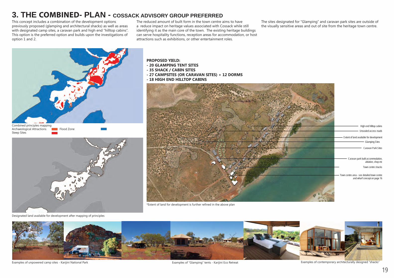
This development option focuses on a combined approach of reinstating some of the towns core with built structures, providing deluxe camping or Glamping opportunities, high end “hilltop cabins” and a caravan park. This approach was preferred by the CAG.
19
3. THE COMBINED- PLAN - COSSACK ADVISORY GROUP PREFERRED
Examples of unpowered camp sites - Karijini National Park Examples of “Glamping” tents - Karijini Eco Retreat Examples of contemporary architecturally designed “shacks”
Glamping Sites
Town centre area - see detailed town centre and wharf concept on page 16
Unsealed access roads
High end hilltop cabins
Extent of land available for development
Town centre shacks
Caravan Park Sites
PROPOSED YIELD: - 20 GLAMPING TENT SITES- 35 SHACK / CABIN SITES- 27 CAMPSITES (OR CARAVAN SITES) + 12 DORMS- 18 HIGH END HILLTOP CABINS
The reduced amount of built form in the town centre aims to have a reduce impact on heritage values associated with Cossack while still identifying it as the main core of the town. The existing heritage buildings can serve hospitality functions, reception areas for accommodation, or host attractions such as exhibitions, or other entertainment roles.
The sites designated for “Glamping” and caravan park sites are outside of the visually sensitive areas and out of site from the heritage town centre.
This concept includes a combination of the development options previously proposed (glamping and architectural shacks) as well as areas with designated camp sites, a caravan park and high end “hilltop cabins”. This option is the preferred option and builds upon the investigations of option 1 and 2.
Designated land available for development after mapping of principles
Combined principles mapping Archaeological Attractions Flood ZoneSteep Sites
Caravan park built accommodation, ablution, shop etc
*Extent of land for development is further refined in the above plan

20
3. THE COMBINED - DEMONSTRATION MODEL
The proposed concept with 1 in 100 year flood level.
The proposed layout of cabins along perseverance street
An aerial overview of concept 3
An aerial showing views from the glamping tents, cabins, and caravan accommodation
Detailed design stages are required to determine specific siting and design of all proposed design elements. Generic models have been used for proposed buildings, tents etc the design details are indicative only.
The follow images are exported from a 3D model to show the general design intent and display the relationship between proposed elements and the landscape.
21
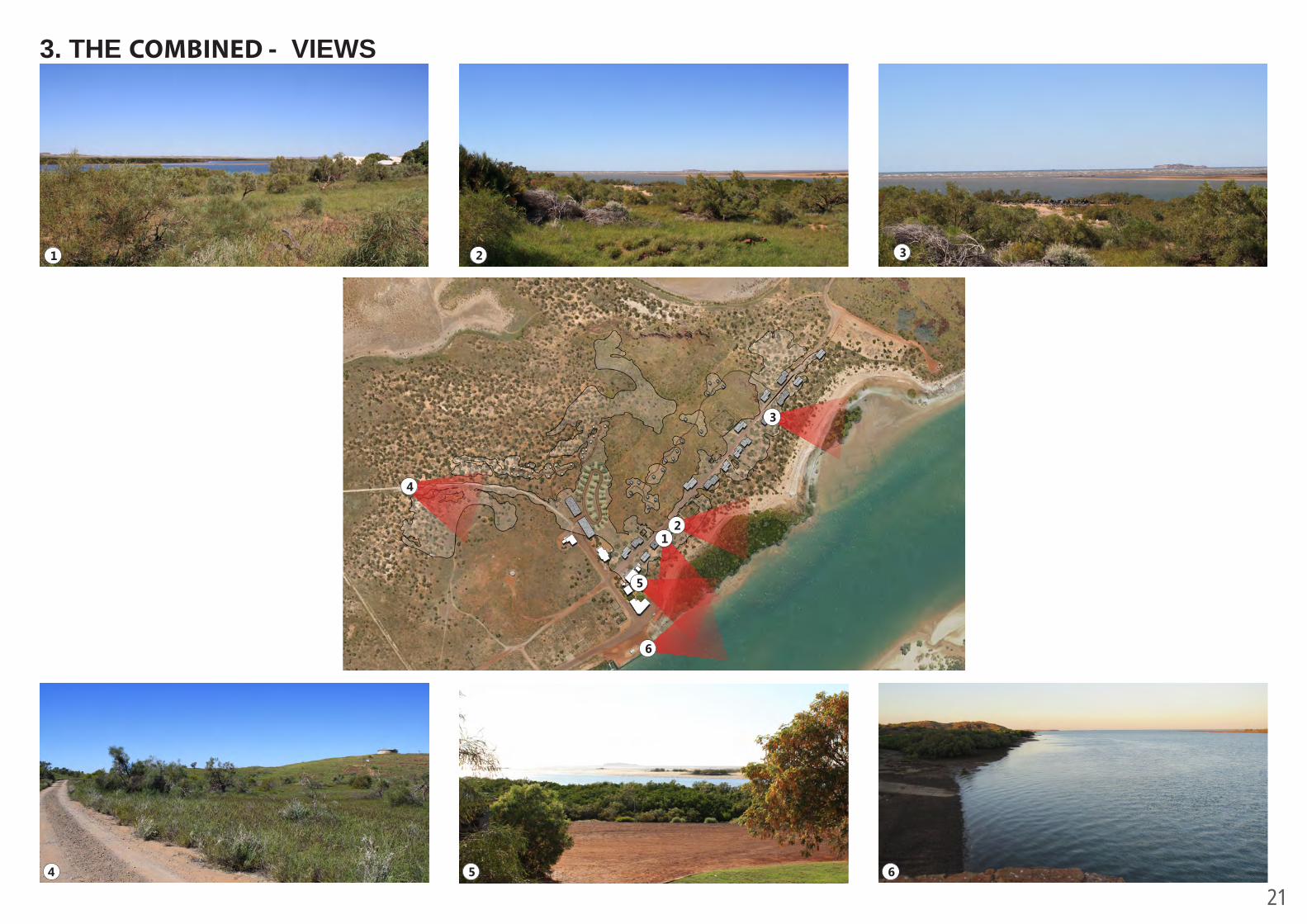
3. THE COMBINED - VIEWS
1 2 3
21
3
4
5
6
4 5 6
22
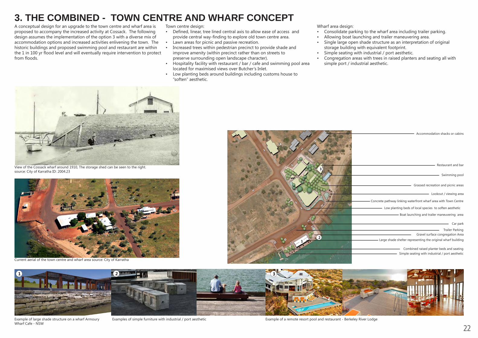
3. THE COMBINED - TOWN CENTRE AND WHARF CONCEPT
Restaurant and bar
Swimming pool
Grassed recreation and picnic areas
Gravel surface congregation Area
Large shade shelter representing the original wharf building
Car park
Concrete pathway linking waterfront wharf area with Town Centre
Accommodation shacks or cabins
Lookout / viewing area
Boat launching and trailer maneuvering area
Trailer Parking
Combined raised planter beds and seatingSimple seating with industrial / port aesthetic
View of the Cossack wharf around 1910, The storage shed can be seen to the right. source: City of Karratha ID: 2004.23
Example of a remote resort pool and restaurant - Berkeley River Lodge Example of large shade structure on a wharf Armoury Wharf Cafe - NSW
Examples of simple furniture with industrial / port aesthetic
1 2 3
3
12
Low planting beds of local species to soften aesthetic
Town centre design:• Defined, linear, tree lined central axis to allow ease of access and
provide central way-finding to explore old town centre area.• Lawn areas for picnic and passive recreation.• Increased trees within pedestrian precinct to provide shade and
improve amenity (within precinct rather than on streets to preserve surrounding open landscape character).
• Hospitality facility with restaurant / bar / cafe and swimming pool area located for maximised views over Butcher’s Inlet.
• Low planting beds around buildings including customs house to “soften” aesthetic.
Wharf area design:• Consolidate parking to the wharf area including trailer parking.• Allowing boat launching and trailer maneuvering area.• Single large open shade structure as an interpretation of original
storage building with equivalent footprint.• Simple seating with industrial / port aesthetic. • Congregation areas with trees in raised planters and seating all with
simple port / industrial aesthetic.
A conceptual design for an upgrade to the town centre and wharf area is proposed to accompany the increased activity at Cossack. The following design assumes the implementation of the option 3 with a diverse mix of accommodation options and increased activities enlivening the town. The historic buildings and proposed swimming pool and restaurant are within the 1 in 100 yr flood level and will eventually require intervention to protect from floods.
Current aerial of the town centre and wharf area source: City of Karratha
23
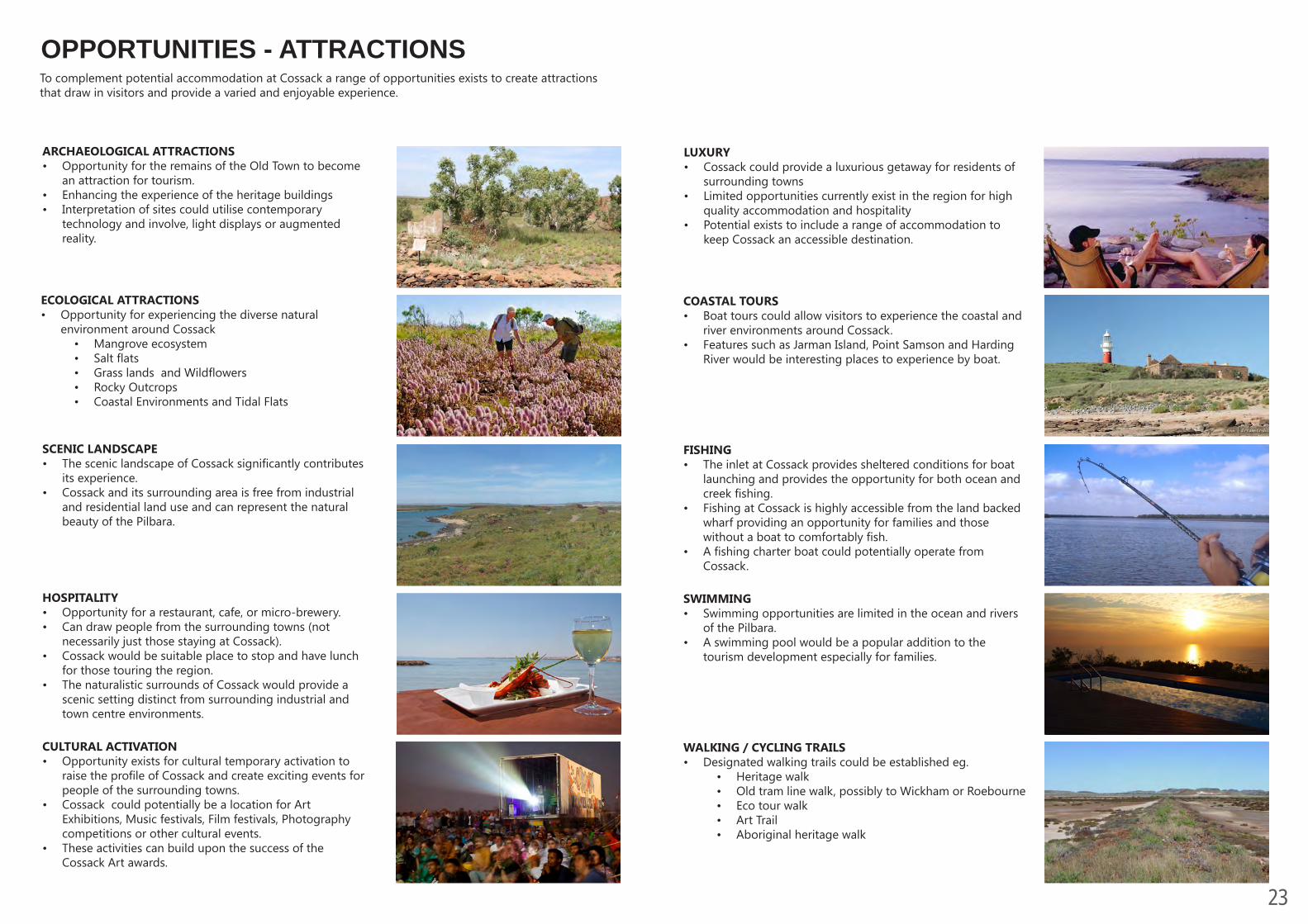
FISHING• The inlet at Cossack provides sheltered conditions for boat
launching and provides the opportunity for both ocean and creek fishing.
• Fishing at Cossack is highly accessible from the land backed wharf providing an opportunity for families and those without a boat to comfortably fish.
• A fishing charter boat could potentially operate from Cossack.
SWIMMING• Swimming opportunities are limited in the ocean and rivers
of the Pilbara.• A swimming pool would be a popular addition to the
tourism development especially for families.
WALKING / CYCLING TRAILS• Designated walking trails could be established eg.
• Heritage walk• Old tram line walk, possibly to Wickham or Roebourne• Eco tour walk• Art Trail• Aboriginal heritage walk
ARCHAEOLOGICAL ATTRACTIONS• Opportunity for the remains of the Old Town to become
an attraction for tourism.• Enhancing the experience of the heritage buildings• Interpretation of sites could utilise contemporary
technology and involve, light displays or augmented reality.
SCENIC LANDSCAPE• The scenic landscape of Cossack significantly contributes
its experience.• Cossack and its surrounding area is free from industrial
and residential land use and can represent the natural beauty of the Pilbara.
OPPORTUNITIES - ATTRACTIONS
LUXURY• Cossack could provide a luxurious getaway for residents of
surrounding towns• Limited opportunities currently exist in the region for high
quality accommodation and hospitality• Potential exists to include a range of accommodation to
keep Cossack an accessible destination.
COASTAL TOURS • Boat tours could allow visitors to experience the coastal and
river environments around Cossack.• Features such as Jarman Island, Point Samson and Harding
River would be interesting places to experience by boat.
CULTURAL ACTIVATION• Opportunity exists for cultural temporary activation to
raise the profile of Cossack and create exciting events for people of the surrounding towns.
• Cossack could potentially be a location for Art Exhibitions, Music festivals, Film festivals, Photography competitions or other cultural events.
• These activities can build upon the success of the Cossack Art awards.
HOSPITALITY• Opportunity for a restaurant, cafe, or micro-brewery.• Can draw people from the surrounding towns (not
necessarily just those staying at Cossack).• Cossack would be suitable place to stop and have lunch
for those touring the region.• The naturalistic surrounds of Cossack would provide a
scenic setting distinct from surrounding industrial and town centre environments.
ECOLOGICAL ATTRACTIONS• Opportunity for experiencing the diverse natural
environment around Cossack• Mangrove ecosystem• Salt flats• Grass lands and Wildflowers• Rocky Outcrops• Coastal Environments and Tidal Flats
To complement potential accommodation at Cossack a range of opportunities exists to create attractions that draw in visitors and provide a varied and enjoyable experience.