Embed Size (px)
Citation preview

Cost-Effective Raster Image Processingfor Geoecological AnalysisUsing ldquoISOCLUSTrdquo Classifiera Case Study of Estonian Landscapes
Presented at 5th International ConferencersquoModern Problems of Geoecology and Landscapes StudiesrsquoBelarus State University (BSU)Minsk Belarus
Who Polina Lemenkova
When October 14 2014
IntroductionStudy AreaResearch AimLandscapes
Examples ofLandscapes
Baltic Sea CoastsMarine Landscapes PaumlrnuLacustrine landscapes LuitemaaaForest landscapes Luitemaa
AnthropogenicImpacts
FactsEcohouses Construction
Data
Methods
Results
Thanks
Bibliography
Study Area Paumlrnu Region Estonia
Study Area The research regionencompasses coastal area ofBaltic Sea south-westernEstonia
Spatial extent Spatial extent of the studyarea is limited to thesurroundings of Paumlrnu County
Research Aim
The purpose of this study is following two aims
GIS Analysis first a geographic (GIS) analysis of land cover types in thecoastal landscapes of western Estonia Paumlrnu surroundingsat two various temporal dates (1992 and 2006)
IDRISI GIS second an overview of the technical methods enablingimage processing by different tools of IDRISI GIS software
Landsat TMImages
Hence the main research methods consists in processingand classification of satellite remote sensing data LandsatTM aimed at land cover types recognition and thematicmapping
Landscapes
South-WestEstonia Unique
Environment
South-west Estonia is known for unique environmentalsettings mild maritime climate broad beaches coniferouspine forests on the coastal zone
Landscapes Landscapes here are rich and world-known for theirdiversity variability unique composition structure and highesthetic value
Examples Types of Landscapes Landscape types include forexample mixed and broadleaved forests traditionalagricultural semi-natural landscapes wooded meadowsplant communities heathland bogs and moors complexanthropogenic areas with different land use structureshrubland grasslands birch-dominating coastal areas andflooded meadows
Examples of Landscapes Baltic Sea Coasts
Examples Landscapes Baltic Sea Coasts Photos author
Marine Landscapes Paumlrnu Coasts
Examples Marine Landscapes Paumlrnu Coasts Photos author
Lacustrine landscapes Luitemaa NatureConservation Area
Examples Lacustrine landscapes Luitemaa Nature ConservationArea Photos author
Forest landscapes Luitemaa NatureConservation Area
Examples Forest Landscapes Luitemaa Nature Conservation AreaPhotos author
Anthropogenic Impacts
TourismActivities
Paumlrnu region is traditionally popular as a tourism destinationdue to favorable combination of factors
geographic value advantageous location on the coasts ofBaltic Sea
social value good facilities for the tourism and tourismreputation
environmental value unique nature (marine landscapespine forests)
AgriculturalActivities
Paumlrnu region is also known for traditional agriculturalactivities (field crops cultivation intensive planting etc) aswell as extensive housing development in the rural area
Human Pressure All these factors create additional human pressure on thelocal ecosystems and may lead to fragmentation of thelandscape structure
Ecohouses Construction
Examples Ecohouses Construction Photos author
Examples Eco-housing
Examples Eco-housing Photos author
Data
The research data used in this project include vector andraster types of data
Raster data Thematic raster layers (GeoTIFF) Landsat TM includingscenes taken on 18 June 2006 and 03 June 1992Both images cover summer months thus enablingvegetation coverage to be easily recognizedThe images were downloaded from the Earth Science DataInterface Global Land Cover Facility
Vector data CORINE vector layers (abbreviation from Coordination ofInformation on the Environment) developed by theEuropean Environmental Agency EU Commission)The CORINE data were stored in ESRI format shape-filesThey contain information on land use types provided by theEstonian Land Board and available at the University of Tartu
Methods
GIS Projects The GIS projects has been organized and executed in twodifferent software Arc GIS 100 and IDRISI GIS Andes 150
Landsat TM The raster processing GIS approach and classification wasapplied in the current work towards Landsat TM twoimages
ISOCLUST The method is based on the ISOCLUST unsupervisedclassification executed by means of IDRISI GIS
MachineLearning
The ISOCLUST available in IDRISI GIS performs the most of theimage processing workflow in semi-automatically regime
Land CoverClasses
It results in a map with pre-defined number of 16 land classcategories which enable to compare two different stagesof landscape development ldquoearlierrdquo and ldquonowrdquo
Objectivity The ISOCLUST method was chosen since it enables to avoidsubjectivity in classification
Workflow Step-1
IMPORT Initially the data of Landsat TM were imported to IDRISIAndes GIS from GeoTIFF format to IDRISI specific format rstthrough Data Provider Format importAs each Landsat TM scene is a multispectral image withseveral spectral bands each band was displayed andvisualized as a separate image
COLORCOMPOSITE
Afterwords the images were composed using ColorComposite functionThe combination of three bands was made as a single colorcomposite image (bands 2-3-4)This composition displays urban areas distinctively whichenables to clearly recognize them
PROJECT Then data were organized in a created project in IDRISI GIS
Workflow Step-1
Examples Image Processing
Workflow Step-2
CLASSIFICATION The next step includes application of chosen classificationmethod of ISOCLUST approach towards images processingISOCLUST classifier technique is based on the histogrampeak selection technique
Analysis ofSpectral
Signatures
The ground principle of the classification consists in theanalysis of spectral signatures that are individual for eachland cover class
Analysis ofSpectral
Reflections
The analysis of spectral reflections strongly depends on thelocal surface features texture structure color etc
SpectralSignatures
Information on spectral signatures is received by the satellitesensors and recorded on the images (in this case LandsatTM) This information is used for the image classification
Examples Information Extraction Using individual characteristics ofobjects derived from the multispectral Landsat TM bandsinformation from the images was extracted analyzed andused for land classification
Workflow Step-3
ImageComparison
Changes in land cover types in selected Estonianlandscapes are shown on the histograms on 1992 and 2006
2006 vs 1992 In 2006 the urban area became larger than in 1992 (landcover class 3 on the histogram This can be explained byvarious reasons
Impact Factors The most important reason is intense suburbanization =gtthe major process in the current urban dynamics of modernEstonia intensive construction of summer homes andcottages in the coastal area
Buildings New buildings and houses created along the Paumlrnu Bay =gtincreased area of urban areas
Image Processing
ISOCLUST ISOCLUST classification of the images enabled to createthematic maps of the same study areas
CORINE According to CORINE there are 16 land cover types typicalfor the study area
Land Cover Classes
discontinuous urban fabric
industrial or commercial units
green urban areas
pastures
complex cultivation patterns
agriculture lands with grass
broad-leaved forest
coniferous forest
mixed forest
natural grassland
moors and heathlands
transitional woodland
beaches dunes sand
island marshes
water bodies
sea and ocean
ThanksThank you for attention
Photo authorAcknowledgementThe research has been done at the University of Tartuunder support of DoRa grant (ESF Estonia)The University of Tartu provided data and softwareCORINE vector layers IDRISI GIS 150 and ArcGIS 100
Bibliography1 S Gauger G Kuhn K Gohl T Feigl P Lemenkova and C Hillenbrand ldquoSwath-bathymetric mappingrdquo
The expedition ANTARKTIS-XXIII4 of the Res Vessel rsquoPolarsternrsquo in 2006 Berichte zur Polar- undMeeresforschung Rep on Polar and Marine Res 557 edited by K Gohl 38ndash45 ISSN 1618-3193 (2007)httpswwwcoldregionsorgvufindRecord288392 In English Ant Acc No 85104 CRREL AccNo 63000887 illus incl sketch maps
2 K Gohl G Eagles G B Udintsev R D Larter G Uenzelmann-Neben H W Schenke P LemenkovaJ Grobys N Parsiegla P Schlueter T Deen G Kuhn and C D Hillenbrand ldquoTectonic and Sedimentary
Processes of the West Antarctic Margin of the Amundsen Sea Embayment and Pine Island Bayrdquo in 2nd
Open Science Conference 29th SCAR on rsquoAntarctica in the Earth Systemrsquo (2006)httpswwwscarorgevents Info
3 K Gohl G Uenzelmann-Neben G Eagles A Fahl T Feigl J Grobys J Just V Leinweber N LenschC Mayr N Parsiegla N Rackebrandt P Schloter S Suckro K Zimmermann S Gauger H BohlmannG L Netzeband and P Lemenkova Crustal and Sedimentary Structures and Geodynamic Evolution ofthe West Antarctic Continental Margin and Pine Island Bay (Bremerhaven Germany 2006)httpsepicAlfred20Wegener20Institutede298521PE_75pdf
4 M Klauco B Gregorovaacute U Stankov V Markovic and P Lemenkova ldquoInterpretation of Landscape ValuesTypology and Quality Using Methods of Spatial Metrics for Ecological Planningrdquo in Environmental amp
climate technologies proceedings of the 54th conference (2013)
5 M Klauco B Gregorovaacute U Stankov V Markovic and P Lemenkova ldquoLandscape metrics as indicator forecological significance assessment of Sitno Natura 2000 sites Slovakiardquo in Ecology and environmentalprotection Proceedings of International Conference () pp 85ndash90httpelibbsubyhandle123456789103362
6 M Klauco B Gregorovaacute U Stankov V Markovic and P Lemenkova ldquoDetermination of ecologicalsignificance based on geostatistical assessment a case study from the Slovak Natura 2000 protectedareardquo Central European Journal of Geosciences 5 28ndash42 ISSN 1896-1517 (2013)httpswwwdegruytercomviewjgeo20135issue-1s13533-012-0120-0s13533-012-0120-0xmlformat=INT
7 G Kuhn C Hass M Kober M Petitat T Feigl C D Hillenbrand S Kruger M Forwick S Gauger andP Lemenkova The response of quaternary climatic cycles in the South-East Pacific development of theopal belt and dynamics behavior of the West Antarctic ice sheet (Bremerhaven Germany 2006)httpsepicAlfred20Wegener20Institutede298521PE_75pdf
8 P Lemenkova ldquoCost-Effective Raster Image Processing for Geoecological Analysis using ISOCLUSTClassifier a Case Study of Estonian Landscapesrdquo in Modern problems of geoecology and landscapesstudies Proceedings of the 5th International Conference edited by A N Vitchenko G I MartsinkevichB P Vlasov N V Gagina and V M Yatsukhno () pp 74ndash76 ISBN 978-985-476-629-4httpswwwelibbsubybitstream1234567891036411geoconf80pdf
9 P Lemenkova ldquoRural Sustainability and Management of Natural Resources in Tian Shan Region CentralAsiardquo in International conference rsquocelebrating pastoral lifersquo Heritage and economic developProceedings International Conference edited by F Papageorgiou () pp 81ndash89 ISBN 978-960-6676-22-2
10P Lemenkova ldquoOpportunities for Classes of Geography in the High School the Use of rsquoCORINErsquo ProjectData Satellite Images and IDRISI GIS for Geovisualizationrdquo in Perspectives for the development of highereducation Proceedings of 7th International Conference edited by V Pestis A A Duduk A V Sviridovand S I Yurgel () pp 284ndash286 ISBN 978-985-537-042-1 httpswwwggaubydownloadsprintsSbornik_72014_konferencii_perspektivy_razvitija_vysshej_shkolypdf
11P Lemenkova ldquoMonitoring changes in agricultural landscapes of Central Europe Hungary application ofILWIS GIS for image processingrdquo in Geoinformatics theoretical and applied aspects Proceedings of 12thInternational Conference ()
12P Lemenkova ldquoImpacts of Climate Change on Landscapes in Central Europe Hungaryrdquo in CurrentProblems of Ecology Ecological monitoring and management of natural protection Proceedings of 8thInternational Conference Vol 2 () pp 134ndash136httpselibgrsubykatalog173327-393652pdf
13P Lemenkova ldquoCurrent Problems of Water Supply and Usage in Central Asia Tian Shan Basinrdquo in
Environmental and Climate Technologies Proceedings of the 54th Conference edited by M Roša (2013)pp 11ndash16 httpsect-journalsrtulvarticleviewiscect2013002275
14P Lemenkova ldquoEffects of Socio-Economic Changes in the Post-Soviet Estonia on the LandscapesDiversification and Tourism Developmentrdquo in Contemporary trends in tourism and hospitality AbstractBook edited by N Mimica-Dukic (University of Novi Sad Department of Geography Tourism and HotelManagement 2013) p 73 httpwwwdgtunsacrsctth2013
15P Lemenkova ldquoCurrent Development of Tourism and Recreation on Baltic Sea Coasts New Directions and
Perspectivesrdquo in The Image and Sustainability of Tourist Destinations Proceedings of the 6th InternationalTourism Congress edited by P Almeida J P Jorge J Costa and F Dias (2013) pp 126ndash132 ISBN978-989-97395-1-2 httpitcipleiriaptprevious-editionsitc13itc13-proceedings
16P Lemenkova ldquoGeospatial Technology for Land Cover Analysisrdquo Middle East and Africa (MEA) GeospatialDigest (2013) httpswwwgeospatialworldnetarticlegeospatial-technology-for-land-cover-analysis e-magazine (periodical)
17P Lemenkova ldquoWater Supply and Usage in Central Asia Tian Shan Basinrdquo in Civil engineeringarchitecture and environmental protection Phidac-2012 Proceedings of the 4th International Symposiumfor Doctoral studies in the Fields of Civil Engineering Architecture amp Environmental Protection edited byZ Grdic and G Toplicic-Curcic (Sept 2012) pp 331ndash338 ISBN 978-86-88601-05-4
18P Lemenkova ldquoSeagrass Mapping and Monitoring Along the Coasts of Crete Greecerdquo MSc Thesis(University of Twente Faculty of Earth Observation and Geoinformation (ITC) Enschede NetherandsMar 8 2011) 158 pp httpsthesiscommonsorgp4h9v
19P Lemenkova ldquoUsing ArcGIS in Teaching Geosciencesrdquo Russian BSc Thesis (Lomonosov Moscow StateUniversity Faculty of Educational Studies Moscow Russia June 5 2007) 58 pphttpsthesiscommonsorgnmjgz
20P Lemenkova ldquoGeoecological Mapping of the Barents and Pechora Seasrdquo Russian BSc Thesis(Lomonosov Moscow State University Faculty of Geography Deparmnet of Cartography andGeoinformatics Moscow Russia May 18 2004) 78 pp httpsthesiscommonsorgbvwcr
21P Lemenkova Ecological and Geographical Mapping of the Baltic Sea Region in the Gulf of FinlandRussian Moscow Russia Lomonosov Moscow State University Mar 30 2002httpszenodoorgrecord2574447 Term Paper
22P Lemenkova and I Elek ldquoClustering Algorithm in ILWIS GIS for Classification of Landsat TM Scenes a CaseStudy of Mecsek Hills Region Hungaryrdquo in Geosciences and environment Near-surface geophysicsProceedings 3rd International Conference edited by S Komatina-Petrovic ()
23P Lemenkova B Forbes and T Kumpula ldquoMapping Land Cover Changes Using Landsat TM A Case Studyof Yamal Ecosystems Arctic Russiardquo in Geoinformatics theoretical and applied aspects Proceedings ofthe 11th International Conference () httpselibraryruitemaspid=24527736
24P Lemenkova B Forbes and T Kumpula ldquoILWIS GIS for Monitoring Landscapes in Tundra Ecosystems
Yamal Peninsula Russiardquo in Remote sensing and global surveillance 3rd International GeosciencesStudents Conference (2012) ISBN 978-86-913953-5-3
25H W Schenke and P Lemenkova ldquoZur Frage der Meeresboden-Kartographie Die Nutzung von AutoTraceDigitizer fuumlr die Vektorisierung der Bathymetrischen Daten in der Petschora-Seerdquo GermanHydrographische Nachrichten 25 16ndash21 ISSN 0934-7747 (2008)
26I Suetova L Ushakova and P Lemenkova ldquoGeoecological Mapping of the Barents Sea Using GISrdquo inDigital cartography amp gis for sustainable development of territories Proceedings of the InternationalCartographic Conference (2005) httpsicaciorgicc2005
27I Suetova L Ushakova and P Lemenkova ldquoGeoinformation mapping of the Barents and Pechora SeasrdquoGeography and Natural Resources 4 edited by V A Snytko 138ndash142 ISSN 1875-3728 (2005)httpwwwizdatgeorujournalphpaction=outputampid=3amplang_num=2ampid_dop=68

Workflow Step-1
Examples Image Processing
Workflow Step-2
CLASSIFICATION The next step includes application of chosen classificationmethod of ISOCLUST approach towards images processingISOCLUST classifier technique is based on the histogrampeak selection technique
Analysis ofSpectral
Signatures
The ground principle of the classification consists in theanalysis of spectral signatures that are individual for eachland cover class
Analysis ofSpectral
Reflections
The analysis of spectral reflections strongly depends on thelocal surface features texture structure color etc
SpectralSignatures
Information on spectral signatures is received by the satellitesensors and recorded on the images (in this case LandsatTM) This information is used for the image classification
Examples Information Extraction Using individual characteristics ofobjects derived from the multispectral Landsat TM bandsinformation from the images was extracted analyzed andused for land classification
Workflow Step-3
ImageComparison
Changes in land cover types in selected Estonianlandscapes are shown on the histograms on 1992 and 2006
2006 vs 1992 In 2006 the urban area became larger than in 1992 (landcover class 3 on the histogram This can be explained byvarious reasons
Impact Factors The most important reason is intense suburbanization =gtthe major process in the current urban dynamics of modernEstonia intensive construction of summer homes andcottages in the coastal area
Buildings New buildings and houses created along the Paumlrnu Bay =gtincreased area of urban areas
Image Processing
ISOCLUST ISOCLUST classification of the images enabled to createthematic maps of the same study areas
CORINE According to CORINE there are 16 land cover types typicalfor the study area
Land Cover Classes
discontinuous urban fabric
industrial or commercial units
green urban areas
pastures
complex cultivation patterns
agriculture lands with grass
broad-leaved forest
coniferous forest
mixed forest
natural grassland
moors and heathlands
transitional woodland
beaches dunes sand
island marshes
water bodies
sea and ocean
ThanksThank you for attention
Photo authorAcknowledgementThe research has been done at the University of Tartuunder support of DoRa grant (ESF Estonia)The University of Tartu provided data and softwareCORINE vector layers IDRISI GIS 150 and ArcGIS 100
Bibliography1 S Gauger G Kuhn K Gohl T Feigl P Lemenkova and C Hillenbrand ldquoSwath-bathymetric mappingrdquo
The expedition ANTARKTIS-XXIII4 of the Res Vessel rsquoPolarsternrsquo in 2006 Berichte zur Polar- undMeeresforschung Rep on Polar and Marine Res 557 edited by K Gohl 38ndash45 ISSN 1618-3193 (2007)httpswwwcoldregionsorgvufindRecord288392 In English Ant Acc No 85104 CRREL AccNo 63000887 illus incl sketch maps
2 K Gohl G Eagles G B Udintsev R D Larter G Uenzelmann-Neben H W Schenke P LemenkovaJ Grobys N Parsiegla P Schlueter T Deen G Kuhn and C D Hillenbrand ldquoTectonic and Sedimentary
Processes of the West Antarctic Margin of the Amundsen Sea Embayment and Pine Island Bayrdquo in 2nd
Open Science Conference 29th SCAR on rsquoAntarctica in the Earth Systemrsquo (2006)httpswwwscarorgevents Info
3 K Gohl G Uenzelmann-Neben G Eagles A Fahl T Feigl J Grobys J Just V Leinweber N LenschC Mayr N Parsiegla N Rackebrandt P Schloter S Suckro K Zimmermann S Gauger H BohlmannG L Netzeband and P Lemenkova Crustal and Sedimentary Structures and Geodynamic Evolution ofthe West Antarctic Continental Margin and Pine Island Bay (Bremerhaven Germany 2006)httpsepicAlfred20Wegener20Institutede298521PE_75pdf
4 M Klauco B Gregorovaacute U Stankov V Markovic and P Lemenkova ldquoInterpretation of Landscape ValuesTypology and Quality Using Methods of Spatial Metrics for Ecological Planningrdquo in Environmental amp
climate technologies proceedings of the 54th conference (2013)
5 M Klauco B Gregorovaacute U Stankov V Markovic and P Lemenkova ldquoLandscape metrics as indicator forecological significance assessment of Sitno Natura 2000 sites Slovakiardquo in Ecology and environmentalprotection Proceedings of International Conference () pp 85ndash90httpelibbsubyhandle123456789103362
6 M Klauco B Gregorovaacute U Stankov V Markovic and P Lemenkova ldquoDetermination of ecologicalsignificance based on geostatistical assessment a case study from the Slovak Natura 2000 protectedareardquo Central European Journal of Geosciences 5 28ndash42 ISSN 1896-1517 (2013)httpswwwdegruytercomviewjgeo20135issue-1s13533-012-0120-0s13533-012-0120-0xmlformat=INT
7 G Kuhn C Hass M Kober M Petitat T Feigl C D Hillenbrand S Kruger M Forwick S Gauger andP Lemenkova The response of quaternary climatic cycles in the South-East Pacific development of theopal belt and dynamics behavior of the West Antarctic ice sheet (Bremerhaven Germany 2006)httpsepicAlfred20Wegener20Institutede298521PE_75pdf
8 P Lemenkova ldquoCost-Effective Raster Image Processing for Geoecological Analysis using ISOCLUSTClassifier a Case Study of Estonian Landscapesrdquo in Modern problems of geoecology and landscapesstudies Proceedings of the 5th International Conference edited by A N Vitchenko G I MartsinkevichB P Vlasov N V Gagina and V M Yatsukhno () pp 74ndash76 ISBN 978-985-476-629-4httpswwwelibbsubybitstream1234567891036411geoconf80pdf
9 P Lemenkova ldquoRural Sustainability and Management of Natural Resources in Tian Shan Region CentralAsiardquo in International conference rsquocelebrating pastoral lifersquo Heritage and economic developProceedings International Conference edited by F Papageorgiou () pp 81ndash89 ISBN 978-960-6676-22-2
10P Lemenkova ldquoOpportunities for Classes of Geography in the High School the Use of rsquoCORINErsquo ProjectData Satellite Images and IDRISI GIS for Geovisualizationrdquo in Perspectives for the development of highereducation Proceedings of 7th International Conference edited by V Pestis A A Duduk A V Sviridovand S I Yurgel () pp 284ndash286 ISBN 978-985-537-042-1 httpswwwggaubydownloadsprintsSbornik_72014_konferencii_perspektivy_razvitija_vysshej_shkolypdf
11P Lemenkova ldquoMonitoring changes in agricultural landscapes of Central Europe Hungary application ofILWIS GIS for image processingrdquo in Geoinformatics theoretical and applied aspects Proceedings of 12thInternational Conference ()
12P Lemenkova ldquoImpacts of Climate Change on Landscapes in Central Europe Hungaryrdquo in CurrentProblems of Ecology Ecological monitoring and management of natural protection Proceedings of 8thInternational Conference Vol 2 () pp 134ndash136httpselibgrsubykatalog173327-393652pdf
13P Lemenkova ldquoCurrent Problems of Water Supply and Usage in Central Asia Tian Shan Basinrdquo in
Environmental and Climate Technologies Proceedings of the 54th Conference edited by M Roša (2013)pp 11ndash16 httpsect-journalsrtulvarticleviewiscect2013002275
14P Lemenkova ldquoEffects of Socio-Economic Changes in the Post-Soviet Estonia on the LandscapesDiversification and Tourism Developmentrdquo in Contemporary trends in tourism and hospitality AbstractBook edited by N Mimica-Dukic (University of Novi Sad Department of Geography Tourism and HotelManagement 2013) p 73 httpwwwdgtunsacrsctth2013
15P Lemenkova ldquoCurrent Development of Tourism and Recreation on Baltic Sea Coasts New Directions and
Perspectivesrdquo in The Image and Sustainability of Tourist Destinations Proceedings of the 6th InternationalTourism Congress edited by P Almeida J P Jorge J Costa and F Dias (2013) pp 126ndash132 ISBN978-989-97395-1-2 httpitcipleiriaptprevious-editionsitc13itc13-proceedings
16P Lemenkova ldquoGeospatial Technology for Land Cover Analysisrdquo Middle East and Africa (MEA) GeospatialDigest (2013) httpswwwgeospatialworldnetarticlegeospatial-technology-for-land-cover-analysis e-magazine (periodical)
17P Lemenkova ldquoWater Supply and Usage in Central Asia Tian Shan Basinrdquo in Civil engineeringarchitecture and environmental protection Phidac-2012 Proceedings of the 4th International Symposiumfor Doctoral studies in the Fields of Civil Engineering Architecture amp Environmental Protection edited byZ Grdic and G Toplicic-Curcic (Sept 2012) pp 331ndash338 ISBN 978-86-88601-05-4
18P Lemenkova ldquoSeagrass Mapping and Monitoring Along the Coasts of Crete Greecerdquo MSc Thesis(University of Twente Faculty of Earth Observation and Geoinformation (ITC) Enschede NetherandsMar 8 2011) 158 pp httpsthesiscommonsorgp4h9v
19P Lemenkova ldquoUsing ArcGIS in Teaching Geosciencesrdquo Russian BSc Thesis (Lomonosov Moscow StateUniversity Faculty of Educational Studies Moscow Russia June 5 2007) 58 pphttpsthesiscommonsorgnmjgz
20P Lemenkova ldquoGeoecological Mapping of the Barents and Pechora Seasrdquo Russian BSc Thesis(Lomonosov Moscow State University Faculty of Geography Deparmnet of Cartography andGeoinformatics Moscow Russia May 18 2004) 78 pp httpsthesiscommonsorgbvwcr
21P Lemenkova Ecological and Geographical Mapping of the Baltic Sea Region in the Gulf of FinlandRussian Moscow Russia Lomonosov Moscow State University Mar 30 2002httpszenodoorgrecord2574447 Term Paper
22P Lemenkova and I Elek ldquoClustering Algorithm in ILWIS GIS for Classification of Landsat TM Scenes a CaseStudy of Mecsek Hills Region Hungaryrdquo in Geosciences and environment Near-surface geophysicsProceedings 3rd International Conference edited by S Komatina-Petrovic ()
23P Lemenkova B Forbes and T Kumpula ldquoMapping Land Cover Changes Using Landsat TM A Case Studyof Yamal Ecosystems Arctic Russiardquo in Geoinformatics theoretical and applied aspects Proceedings ofthe 11th International Conference () httpselibraryruitemaspid=24527736
24P Lemenkova B Forbes and T Kumpula ldquoILWIS GIS for Monitoring Landscapes in Tundra Ecosystems
Yamal Peninsula Russiardquo in Remote sensing and global surveillance 3rd International GeosciencesStudents Conference (2012) ISBN 978-86-913953-5-3
25H W Schenke and P Lemenkova ldquoZur Frage der Meeresboden-Kartographie Die Nutzung von AutoTraceDigitizer fuumlr die Vektorisierung der Bathymetrischen Daten in der Petschora-Seerdquo GermanHydrographische Nachrichten 25 16ndash21 ISSN 0934-7747 (2008)
26I Suetova L Ushakova and P Lemenkova ldquoGeoecological Mapping of the Barents Sea Using GISrdquo inDigital cartography amp gis for sustainable development of territories Proceedings of the InternationalCartographic Conference (2005) httpsicaciorgicc2005
27I Suetova L Ushakova and P Lemenkova ldquoGeoinformation mapping of the Barents and Pechora SeasrdquoGeography and Natural Resources 4 edited by V A Snytko 138ndash142 ISSN 1875-3728 (2005)httpwwwizdatgeorujournalphpaction=outputampid=3amplang_num=2ampid_dop=68
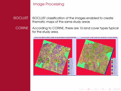