Embed Size (px)
Citation preview

1
Could the Arabs of the 7th and 8th centuries
accurately determine Qibla direction? Part Five of Early Islamic Qiblas
Copyright 2016
Dan Gibson
All rights reserved. No part, concept, or discovery of this paper may be used or reproduced by any means, graphic, electronic, or mechanical, including photocopying, recording, taping or by any
information storage retrieval system without the written permission of the author except in the case of brief quotations embodied in critical articles and reviews.

2
Introduction
In the paper: Early Islamic Qiblas (1) I examined over 60 early mosques, most of them built in the first two centuries of Islam. While I am sure there are many more, these are the ones that sufficient ruins have survived or descriptions have survived that allow us to include them in our study.
Following that paper, I wrote papers addressing the following topics: (2) The Accuracy of Google Earth, (3) Visiting a Mosque, and (4) the Qibla Misunderstanding.
In this study (5) we turn our attention to the question of how the earliest qibla directions might have been calculated, addressing the myth that the Arabs of the sixth and seventh centuries did not have the tools or techniques to correctly align their Qiblas.
The 1986 Encyclopedia of Islam, Volume 5, page 88 states:
Another reason why mosques may be incorrectly aligned is that their qiblas were not computed from geographical data at all but were inspired by tradition. Thus, for example, mosques in the Magrib and the Indian subcontinent generally face due east or due west, respectively. Likewise, in early Muslim Egypt the Qibla adopted was the azimuth of the rising sun at the winter solstice. Several mosques in Cairo face this direction, which was favored as the qiblat al- ṣaḥāba, but which is about 10˚ off the qibla computed mathematically using mediaeval geographical coordinates and about 20˚ off the true qibla for Cairo. No survey has yet been made of the orientation of mediaeval mosques. Such a survey would be of considerable interest for the history of Islamic architecture as well as the history of science.(Emphasis is mine).
My own small survey done over the last 20 years is a step in this direction, visiting as many of the early mosques as I could find, taking photographs, examining foundations, and checking the qibla direction. I must thank the Massachusetts Institute of Technology (MIT) and the website: archnet.org who have been most helpful in providing architectural information on many mosques.
Also, please note that when quoting Chinese sources I use the outdated Wade-Giles Romanization of Chinese script with older sources and modern pinyin with modern sources.
Dan Gibson

3
Could the Arabs of the 7th and 8th centuries accurately determine Qibla directions?
From my survey of Early Islamic Qiblas, I discovered that during the first 100 years of Islamic history, all Islamic Qiblas pointed to Petra. During the second hundred years (which I call the Time of Confusion) some Qiblas pointed to Mecca, some pointed to between Mecca and Petra and some were parallel to a line drawn between Petra and Mecca. They did this with surprising accuracy which seems to indicate that the early Muslims did indeed have accurate tools and techniques for establishing Qibla directions.
When confronted with the growing archeological evidence supporting a Petra Qibla, several people have argued that the Arabs of 7th and 8th centuries would not have had the technology needed to accurately determine a Qibla direction. This argument is often based on reasoning that goes like this: “Today we are much more advanced than those Arabs, and since I could never determine the direction of the Qibla without a GPS then I doubt that they could do it accurately.” Another argument states: “The Arabs of the Arabian Peninsula were land-bound, using camel caravans. Using the stars as a method of finding direction was something sailors did. So how could the Arabs of Arabia know with any accuracy how to determine the Qibla?” The goal of this paper is to demonstrate that there were early Muslims that had the tools and techniques to accurately determine a mosque’s Qibla direction.
Examining an account Al Ṭabarī records a description of the founding of the Al Aqsa mosque in Jerusalem, and the setting of its Qibla soon after the Arab armies occupied the city.1
He (’Umar) then went on and entered the masjid (congregational) area. Then he went on towards the miḥrab of David, while we were with him; he entered it, recited the prostration of David and prostrated himself and we prostrated ourselves with him. …. then he said “Bring Ka’b to me.” Ka’b was brought to him. ’Umar said “Where do you think we should establish the place of prayer?” Ka’b said “Towards the Rock.” ’Umar said “O Ka’b, you are imitating the Jewish religion! I have seen you taking off your shoes.” Ka’b said “I only wanted to touch this ground with my feet.” Umar said “I have seen you. No, we shall place the qibla in the front of it; the Messenger of God likewise made the front part of our mosques the qibla. Take care of your own affairs, we were not commanded to venerate the Rock, but we were commanded to venerate the Ka’ba.”
1. Volume XII, translated by Yohanan Friedmann, page 193 (#2408)

4
After this Ka’b set the Qibla direction and the Al-Aqṣa mosque was constructed on the Temple Mount facing Petra. The question arises, how did Ka’b determine the Qibla direction? Before answering this question, we need to understand more of what tools would have been available to Ka’b and what techniques were known to him. First, it will take us many pages to cover the tools and techniques that Ka’b would have had access to, and then we will turn our attention to how he could have used those tools to accurately establish the Qibla of the Al Aqsa mosque.
From my studies I have come to the conclusion that the knowledge of using the stars for navigation was common among the early Nabataean Arab merchants who traveled the trackless deserts before the arrival of the Roman armies. Once northern Arabia was absorbed into the Roman province of Syria, with its system of roads and milestones, this knowledge was soon lost, perhaps within a generation.
Arab and Chinese astronomy Let’s begin with an age old question: Who developed stellar navigation first, the Chinese or the Arabs? Joseph Needham argues in his three volume series Science and Civilisation in China2 that celestial navigation was developed simultaneously by the Chinese and the Arabs. However, on reviewing Needham’s arguments, and what we have learned since 1959, I believe the Arabs had this knowledge first, and that it was transferred to China around the first century CE.
The Chinese had very rudimentary calendars in 1st century CE as seen by Ta Tai Li Chi. (Record of Rites of Tai the Elder).3 However Needham notes that in the 3rd century BC, there is a story of a Chinese ruler collecting a set of observations about the stars (of more than 200,000 characters) entitled “Master Lu’s Spring and Summer Annals” supposedly containing observations pertaining to the heavens, earth and the myriad objects in the universe. No records of this have survived to this day. Needham then points out that the astronomical writings of the Chinese begin about 3rd century BC in the form of two books known as Thien Wen (Astronomy of Sish Shen) and the Thien Wen Hsing Chan. (Astronomical Star Prognostication)4 These books disappeared from the bibliographies of the dynastic histories in the 6th century AD and were replaced by Ku Chin Thung Chan (Compendium of Astrology, New and Old) of Wu Mi. These were lost in the Mongol period, but portions are contained in later writings.
2. Needham, 1959 3. Needham, 1959, vol. 3, pg 194 4. Needham, 1959, page 196-197

5
The debate over who first started using the stars for navigation (as opposed to using the stars for fortune telling) must take into account that there was contact between the Nabataean Arabs and the Chinese during the first centuries BC and CE. The chart below demonstrates multiple contacts between the Chinese and the Middle Eastern empires. Note that the first known contact was around 100 BC.5
Major Chinese Sources
Source Date Written Referring to events
Shih Chi, ch. 123 90 BC 100 BC
Chhien Hans Shu, ch. 96a 100 BC 100 BC
Hou Han Shu, chs. 116,118 450 AD 97 AD
Wei Lueh in San Kuo Chih, ch. 30 Before 429 AD 220 - 264 AD
Chin Shu, ch. 97 635 AD 265 - 419 AD
Sung Shu, ch. 97 500 AD 420 - 478 AD
Liange Shu, ch. 54 629 AD AD 502 - 556 AD
Wei Shu, ch. 102 and Pei Shih, ch. 97 572 AD 386 - 556 AD
Thang Shu, Chiu ch. 198 950 AD 618 - 906 AD
Thang Shu, Hsin, ch 221, a,b 1061 AD 618 - 906 AD
Nestorian Stone 781 AD 719 AD
Sung Shih, ch. 490 1345 AD 960 - 1279 AD
Chu Fan Chih 1225 AD 1225 AD
Ming Shih, ch. 326 1739 AD 1368 - 1643 AD
The Chinese text that is of real importance to us is not mentioned by Needham. In order to understand the contact between the Nabataeans and the Chinese we must turn to what is known as Xiyu chuan (Chapter on the Western Regions) taken from Hou Han shu 88. The Hou Han shu, the official history of the Later (or ‘Eastern’) Han Dynasty (25-221 AD), was compiled by Fan Ye who died in 445 AD. Fan Ye used a number of earlier histories including the Shi ji by Sima Qian and the Han shu by Ban Gu, plus many others (including some that were also entitled Hou Han shu) most of which have not survived intact. The particular chapter of interest to us is the History of China which covers 25 - 55 AD. John Hill recently completed a translation of this text and has made it available over the internet, complete with his notes.
5. This chart is adapted from material presented in "Science and Civilisation in China" by Joseph Needham, Vol. I, Cambridge University Press, 1954, pages 192-193
6. At the time of this writing, Hill’s book has not yet been officially published but is due out soon. As I understand it, once the book is published the internet site will be taken down. (Hill, 2003)
6
In the appendices of his book in section B titled The territories of Haixi, Haibei and Haidong, Hill tells us that the Chinese envoys to Arabia brought back with them some Arab “musicians and some skilful jugglers who performed transformations, belched fire, changed the head of an ox to that of a horse, amputated limbs, and then replaced them. They also know how to play with little balls and can keep as many as ten in the air at a time.” This passage demonstrates that not only were the Chinese exploring the western world, but Arabs had traveled to China during the height of the Nabataean merchant empire. Since there was communication between the Nabataean Arabs and the Chinese, the question of who first developed astronomy and the science of celestial navigation will probably never be sorted out, but it will help us understand why there are early mosques in China. And, as the Chinese were observers of Arab navigation, some of their writings provide us with new evidence, as well as substantiating what later Arab writers surmised of the early days of Arab navigation. We are also going to search the Greek and Roman classics for more clues as well.
It would seem however, from the Chinese records, that astronomy and astrology were very much connected in their minds, and that the Chinese study of astronomy was very much focused on astrological projections and calendrical science rather than navigation using the stars. The Arabs on the other had good reason to develop celestial navigation. Navigation by the stars likely developed on land, not on the seas This may come as a surprise, as few people have researched the development of celestial navigation in Arabia. Many of the early works on astronomy, be they Babylonian, Assyrian, Egyptian or Chinese, were actually works on astrology.7 Most people never wandered far from home or from well marked paths, and therefore had little need for developing celestial navigation, as they could easily tell their location based on the things they observed around them. The Nabataean merchants on the other hand had a need for navigating the deserts by using the stars. In order to avoid taxes and confrontation with people who were trying to take advantage of camel caravans passing through their territory, they deliberately took their camel caravans into the vast deserts of Arabia. In chapter eleven of Qur’anic Geography8 I explain how the Nabataeans developed rain-water collection systems to provide water for their camels. Additionally, in order to find these hidden water systems they needed a system to guide them across the trackless desert plains. 7. Pines, 1964 8. Gibson, Qur’anic Geography, page 149

7
During the years I spent in the Arabian deserts, I noticed that the stars were much brighter than what I had observed in Europe and North America. There are several reasons for this. First, I was outdoors much more than I was in Europe or North America. The weather also had something to do with this. In Arabia there are many months of the year when the skies are clear of clouds. Also, the air is much clearer in the desert, where there is little humidity and little air pollution. Added to this, the Arabian deserts have nearly twelve hours of darkness. Since people only sleep an average of eight hours, this means that once the caravans stopped traveling during daylight hours, the Arab merchants had several hours of darkness before they needed to go to sleep.
When camping in the desert, we would spend several hours around the campfire, as there was little we could do in the darkness. For the Bedouins, this is their principle time of socializing, telling stories and exchanging knowledge. I remember many evenings sitting around a smoldering fire. As the coals glowed, the men would engage in story-telling, and the women would come from the women’s side of the tent and gather around, just outside of the glow, so we could not see them, but we could feel and hear their presence.
One could easily imagine the caravan leaders taking the youth away from the fire and turning their focus to the stars. Using parts of their body and simple mathematics, they could measure the stars and determine their way across the desert.
The ancient Arabs tell us that there were two types of navigation. The first was known as ishārāt or the knowledge of guides and aids, such as mountains, valleys, and rock formations.9 The second type of navigation was known as majra, or taking celestial bearings from a specific point. Once the celestial direction was established the navigator would use ishārāt along the way during daylight hours. Most Arab navigation books are divided into two sections, one dealing with ishārāt and the other dealing with majra.9
After years of using this system of navigation across the desert, the Arabs adapted it for use aboard ships. Thus it is no surprise to discover that it was the Arabs who took to the high seas first, and not the Chinese. It was Arab ships that plied the ports of India and China, and not the other way around. When Ferdinand Magellan made his famous journey around the world, he relied on an Arab navigator and Arab charts to guide him. 9. Tibbetts, Arab Navigation, Royal Asiatic Society, 1981, Page 33 & 271

8
What Tools Were Available?
Today, most books on navigation deal with navigation on the water. Celestial navigation on land is seldom addressed. In my research I discovered that the Arabs used only a handful of tools, and some very simple math. The secret to understanding this is to put aside what you may know of navigation and mathematics and try to understand from an early Arab perspective what they were doing. I discovered something similar to this when studying the Arabic language in my early twenties. As long as I tried to understand Arabic grammar through English grammar I struggled. When I put English grammar aside and learned the Arabic terms and meanings I began to understand Arabic grammar structure.
In much the same way, we need to put aside our modern concepts of math and geometry and try to think from early Arab perspectives. The first challenge is that they did not think in terms of latitude and longitude coordinates. Using these will only bring confusion. The Arabs had no desire to map the world; they only wanted to determine where locations were over the horizon. Second, the Arabs had 224 degrees10 in their circle and not 360 degrees, which is a number we seem to have adopted from the Babylonians, who used base 60.
Using qiyās
Before the invention of the compass, watch and sextant, the Arab’s main guide was determining how far north or south he was. To obtain this, Nabataean Arab merchants measured the height of a known star above the horizon. Most often this was the Pole Star or North Star, since this star was the one that did not move in the sky. They simply had to identify this star, and then directly measure its height above the horizon. This was the simplest method, and was known as the science of qiyās (measurement).
You can read extensively about this in Aḥmad ibn Mājid al-Najdī’s book: Kitāb al-Fawā’id fi uṣul al-baḥr wa’l-qawā’id. (1421) This book has been translated by G. R. Tibbetts and published under the title: Arab Navigation in the Indian Ocean before the coming of the Portuguese. (The Royal Asiatic Society of Great Britain and Ireland, 1981). This book tells us how the early Arabs used both ishārāt as well as majra to navigate.11 Fortunately, ibn Majid gives us some clues as to how the Arabs navigated in previous ancient times and how navigation developed up until his time. 10. Journal of the Asiatic Society of Bengal, Volume 7, Extracts from Mohit, a Turkish work on navigation in the
Indian seas. Translated and communicated by Joseph Von Hammer, Baron Purgstall, Aulic Counsellor and Prof. Orient. Lang. at Vienna, Translation of the Mohit, 1838, Page 770
11. ishārāt are local guides and majra are celestial guides, see page 7 above.

9
The early science of qiyās involved holding fingers out at arm’s length and using them to measure the height of the Pole Star from the horizon. The Pole Star raises or drops in the night sky as one moves north or south. Each finger was called an iṣba’. The iṣba’ was further divided into 8 zām. Thus distances were often measured in zāms.12
To standardize the iṣba’ measurement Arabs considered the bright star al-‘Aiyūq (Capella) to be 4 iṣba’ (fingers) or one dhubbān away from the nearby star called Dhubbān (β-Aurigae).
Over the years I have tried various experiments measuring zāms by hand and I’ve discovered that this seems to work for the average human, no matter how tall nor how short. When holding the hand at arm’s length, it is possible to measure the height of the North Star by simply placing one hand over the other, and then deciding where on the final finger the Pole Star was located, thus measuring the iṣba’ (number of fingers) and the zāms (1/8th of a finger.) If a person had short hands, or very thick fingers, they could always check the width of their finger by comparing it to the width between Capella and β-Aurigae and adjust accordingly.
12. Facey, 1991, page 99
10
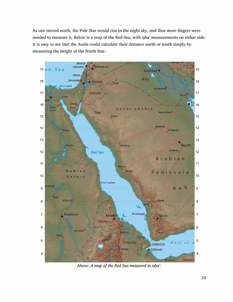
As one moved north, the Pole Star would rise in the night sky, and thus more fingers were needed to measure it. Below is a map of the Red Sea, with iṣba’ measurements on either side. It is easy to see that the Arabs could calculate their distance north or south simply by measuring the height of the North Star.
Above: A map of the Red Sea measured in iṣba’.

11
Some basic tools
A more accurate but still simple instrument was known as a kamāl. This was a small parallelogram made of horn or wood measuring about one by two inches, with a string inserted in the center. On the string were nine knots at measured intervals. The end of the string was held in the teeth. The lower edge of the horn was placed on the horizon, while the horn was moved along the string until the upper edge touched the required star. The knot at which the horn covered the exact distance signified a certain number of iṣba’ or altitude of the star. The altitude of the Pole Star could then be deduced. If the horizon was difficult to determine, the Arabs would simply hold the kamāl so that the bottom was level to their eyes. (See Stellar navigation by the Arabs by Hasan Salih Shibab in The Principles of Arab Navigation, by
Constable and Facy, pg 27)
An alternative way of using a kamāl was to move the knots through the teeth until the piece of horn or wood covered the required star altitude. Vasco da Gama’s pilot from Malindi used a kamāl, and the Portuguese adopted it and eventually modified the spacing of the knots to measure degrees. 13 Sometimes Arab and Indian seamen added extra knots marking the latitudes of particular ports of call, or they simply used a kamāl on which all the knots indicated particular cities in the desert or ports of call on the ocean. This worked well on the flat
desert plains, and allowed the merchants to accurately determine their latitude. 14 Larger pieces of wood were used when measuring higher stars. Traditionally there were three sizes of kamāl, 4, 8, and 12 iṣba’. Many aspects of using the kamāl were passed from sailing masters to novices and never written down, so things like the exact use of things like lunar mansions in relation to individual star heights is still not fully understood. 13. Parkin, David and Barnes, Ruth, Ships and the Development of Maritime Technology on the Indian Ocean, page
219 14. See: http://www.dielette.fr/2014/09/06/kamal-connaissez/ for more on the kamāl.

12
Another method of calculating the star height was to use a simple protractor, based on a 224 degree circle, or 112 degree protractor. This was half (or less) of a full Arab Rose Compass. Below is a photograph of a quadrant from the 8th century (named because it is 1/4 of a full circle.)
A weight was attached to a string and suspended from the center point. The user simply had to point the flat edge of the protractor to the star, and the string would fall onto the marker of iṣba’ or zām.
While these tool were useful in measuring the height of the north star, or any other star in the sky, measuring distance east and west was much more work.
13
The origins of western longitude
The western world thinks in terms of latitude and longitude. For us the ’prime meridian’ or 0° longitude (along with the opposite meridian at 180° longitude) forms a great circle that divides the Earth into the Eastern and Western Hemispheres. In western thought this line runs through Greenwich, England, the site of the Royal Observatory which is where the English people happened to be situated when they came up with this concept. The English however, were thinking in terms of sea travel, and they used time as their constant measurement. The Earth spins west to east at a very even pace, moving 15° each hour. Using the sun as a marker and a clock to give a constant measure, they could use the earth’s rotation to calculate their position in relation to their starting point at 0°. The English set their chronometers to noon when the sun was at its highest point. Later, when they were at 3:00 PM, it meant that three hours ago the sun was overhead at 0° longitude. In those three hours, the sun moved 15° each hour for a total of 45°, so they were at 45° west longitude. This worked well after the clock had been invented. But without the clock, the western world struggled to measure longitude. Accurate clocks only began to appear in the 16th century. It was not until 1760 that an Englishman named John Harrison invented an exact chronometer, making possible the measurement of longitude at sea. So how did the Arabs do it long before clocks and latitude and longitude were developed?
Distance, not time The Arab secret was to use distance, not time when measuring longitude. Using the North Star, they could accurately determine if they were traveling north or south and how far they had traveled. However, since they could not measure time accurately, they turned to distance. In order to do this, they used nothing more complicated that their own bodies. If iṣba’ (fingers) could be used to determine the height of the North Star, then distance could be used to determine how far one must travel directly north to raise the North Pole one zām (⅛ of an iṣba’ or finger width). This distance was measured using the rhythm or beat (ḍarba) of one walking, which was measured in taf ’īla. (feet or meters of verse).15 15. Moreh, 1976, page 208

14
This method requires someone to count the number of steps as they traveled from their source. By using the number of steps and the Arab compass they could accurately determine how far they had traveled east or west. Now, contrary to popular opinion, the Arab merchants of antiquity did not usually ride camels when traveling in the desert. Camel drivers walked and the camels carried heavy loads. Thus, distance in the desert was measured by the steps of an average human being. Pliny the Elder, a Roman historian, is probably the earliest record we have that observes that the Arabs measured with steps. The Arabs told Pliny that the trip from Timna, the capital of Qataban in Yemen, to Gaza on the Mediterranean Sea was 2,437,500 steps, or 62 days by camel.16
This is very close as the distance is around 2,500 kilometers. Since there are around 1000 steps in a kilometer, there were around 2.5 million steps between Yemen and Gaza. In order to travel this distance in 62 days, the camel caravans would have had to travel around 40,000 steps, or 40 kilometers per day. This meant that the camel caravan moved around 40 kilometers or 24 miles in 12 hours, or 2 miles an hour. Pliny found it surprising that the Arab merchants knew the exact number of steps. However, when calculating latitude and longitude, this measurement became extremely important, as it was the primary accurate measurement they could use without accurate timekeeping.
The problem that you and I would have in doing this kind of measurement is not mixing up our numbers while walking. Many times my sons and I would try counting our steps as we walked and thus measure the distance we had traveled. The first several thousand steps usually went well, but after that keeping track of our counting became a problem. The importance of poetry The Arabs developed a fascinating way of measuring their steps. Rather than count, they would recite poetry. Each poem had rhythm of a known length. By walking in rhythm and chanting the poem out loud, the Arabs could enjoy the trip and know the exact distance they had traveled down to the exact number of steps without counting. Thus long poems and poetry became extremely important to the Arabs in pre-Islamic times. People who could create and memorize long poems were highly valued.17
16. Pliny XII, Chap. XIII 17 Baerlein, Henry, The Singing Caravan, Some echoes of Arabian Poetry, London, 1910

15
Albert Hourani, one of the great modern Arab scholars, has said that his people are more conscious of their language and the place of poetry than any other people in the world.18 This consciousness was obsessive. Language was everything to the Arab. It was a divine expression and stemmed from the pre-Islamic era where Al-Kutbi was the god of writing, and those who could create and write epic poems were highly esteemed.
Today, Qur'ānic Arabic is considered by many Muslims to be the pure language that God speaks, and those who speak it well are more honored than those who do not. Language in the form of local dialects also separates those who are near and far (blood lines). It separates the educated from the uneducated. Arabic is an art form, and for centuries was the near sole medium of artistic expression in the Arabian deserts. Every Arab tribe had its poets and their unwritten words “flew across the desert faster than arrows.” As Hourani observes, poetry was not meant to be written; it was designed to be memorized and recited. In the midst of outward strife and disintegration, these poems provided a unifying principle. Poetry gave expression and contained the idea of Arabian virtue. Based on the tribal community of blood lines and insisting that only ties of blood were sacred, poetry became an invisible bond between diverse clans, and formed the basis of a larger sentiment.
It was poetry, the ultimate Arab art form, which bound Arabs together as a people rather than a collection of warring tribes.
When it became apparent that a young person was gifted as a poet, neighboring clans would gather together to wish the family joy. There were feasts and music. Men and boys congratulated one another, for a poet was a defense to the honor of the entire tribe and “a weapon to ward off insult from their good name, and a means of perpetuating their glorious deeds and of establishing their fame forever.”19
It is interesting to note that traditionally Arabs only wish one another joy on three occasions: The birth of a boy, the coming to light of a poet, and the foaling of a noble mare.20
18 Hourani, 1991, pages 12-14 19 Nicholson, 1993, page 71 20 McDonald, 1978

16
The Arabic language is so powerful that Arabs will listen intently to someone speaking well, whether he speaks the truth or not. “I lift my voice to utter lies absurd, for when I speak the truth my hushed tones scarce are heard.” 21
Anyone wanting to understand Arab culture must be a student of Arab poetry. Arab poetry is full of glory. The poets glorified themselves, their brilliant feats, their courage and resolution, and their contempt for death. The Arab hero is defiant and boastful, and when there is little to lose he will ride off unashamed, but he will fight to the death for his women. An example of the ideal Arab hero is Shanfara of Azd. He was an outlaw, swift runner, and excellent poet. As a child, Shanfara was captured by the Bani Salmān tribe and brought up among them. He did not learn of his origin until he was a grown man. He then vowed vengeance against his captors and returned to his own tribe. He swore that he would slay a hundred men of the Beni Salmān, and he had slain ninety-eight when he was caught in an enemy ambush. In the struggle, one of his hands was hewn off by a sword stroke, but taking the weapon in the other, he flung it in the face of a Salmān tribesman and killed him, making his score ninety-nine. He was then overpowered and slain. Much later as his skull lay bleaching on the ground, a man of his enemies passed by and kicked it. A splinter of bone entered his foot; the wound festered and he died, thus completing Shanfara’s hundred. All of this is told in wonderful poetic language, skillfully blending the use of poetry with the honor of the hero.22 Anyone wishing to be a student of Arab history must realize the importance of poetry, not only in its message, but also in its form, rhythm and measure. It is used today to give rhythm to all sorts of labor, from building construction to baking bread. To the Arab merchants of long ago, poetry was the backbone of their secret skill of navigation. It not only helped them pass the long hours as they walked through the desert; it provided them with a tool to accurately measure the distance they traveled. 21. Abū ’Alā' Al-Ma’arī, Syrian poet, 973-1057 AD, Nicholson, 1993, page 319 22. Aḥmad, 2004, pg 16

17
Arabic poetry
Most of our knowledge of early Arabic poetry comes from Abū ’Abd al Raḥmān Khalīl ibn Aḥmad al Farāhīdi (More commonly known as Al Farāhīdi) (718 AD– 791 AD). Al Farāhīdi, as he is commonly known, wrote Kitāb al-’Ayn, an early dictionary of the Arabic language (in 8 volumes). He also collected samples of fifteen scales of poetry and compared them with the Qur'ān.
Because the day of desert caravans and navigation by the stars had long passed, Al Farāhīdi called the meter of the poem the wazn (weight or scale) rather than the earlier term of taf ’īla. He also called each line the bayt or house (verse), which could be divided into sections called shaṭr (halves) or hemistich (a half-line).23
Al Farāhīdi classified poetry into fifteen types based on their wazn. The most common of these are: Ṭawīl, Kāmil, Wāfir, Rajaz, Hazaj, Basīṭ, Khafīf, and Ṣāri’. These more modern forms overshadowed the importance of the ancient beat (ḍarba measured in taf ’īla) which was so important to the early navigators.24
Unfortunately for us, Al Farāhīdi’s treatise on poetry came 180 years after the revelation of the Qur'ān, and by this time poetry was an art form and no longer a part of navigation. In Farāhīdi’s time armies, not camel caravans, marched across the world from city to city along well marked roads, many of them designed to move Roman armies quickly to the edge of the empire. By this time the armies of Rome were retreating from the Roman frontier to deep within their empire, and the enemy armies now used these same roads.
The use of poetry and song for navigation is not unique to the Middle East. In 1987 Bruce Chatwin published the book Songlines which described the Australian aboriginal method of using songs to track routes in the desert. “The Aborigines’ highly evolved method of mapping creates a “labyrinth of invisible pathways which meander all over Australia and are known to Europeans as ‘Dreaming-tracks’ or ‘Songlines’; to Aboriginals as the ‘Footprints of the Ancestors’ or the ‘Way of the law’.”25 23. Al Faruqi, 1975 24. Moreh, 1976, pg 208 25 Chatwin, Bruse, The Songlines, (New York: Viking, 1987), Also check out O’Rourke, Walking and Mapping: Artists as Cartographers and Dittrich, Sara, Wayfinding: Walking in Nomadic and Urban Culture, 2013

18
So once the caravan masters knew their north-south position (measured in qiyās) and the distance they had traveled (measured in taf’īla), they could turn to another tool, the Arab Compass, to determine the angle they were traveling on. Combined with knowledge of the terrain, these Arabs could navigate anywhere in the northern hemisphere. Is it any wonder that once Arabs had travelled by land to China that a few years later Arab boats set out straight across the Indian Ocean for the other side? Is it any wonder that when Marco Polo visited China the harbors were jammed full of Arab boats? Is it any wonder that a mosque was built in Canton China (modern Guangzhou) while Muḥammad was still alive, with its Qibla pointing directly at Petra? And lastly, is it any wonder that algebra and geometry were significantly developed in the Muslim world?
The Arab Compass
Another tool the Arabs used was the Arab Compass. For the Arab navigator, the horizon was divided into 32 akhnām or directions, rather than just N, S, E, W. Thus young Arab navigators had to memorize the names of the 32 locations. Today each of the 32 akhnām are 11 ¼ degrees, making 360 in total by today’s measurement. As some early Arabs used base 7 in their mathematics, the Arab compass is naturally divided into 224 degrees, with seven degrees separating the main 32 points.
Above: The 32 points of the compass and the star names associated with them.

19
Above: The 32 star names on the horizon, and their corresponding directions
Before any math was done, the Arab navigator would know how far north or south he was by measuring the height of the North Star each day in zāms. He could tell in what direction he was traveling by using the 32 points on the horizon and comparing his direction to the stars. Calculations were usually made in the evening when the stars rose on the right and again in the morning when stars set on the left. Other measurements were made during the night hours when the stars reached their zenith. Often directions were given by using star names. This makes reading confusing to us as the Arabs would not mention 77 degrees, nor East of North, but would say something like: travel until the mountain is at al Nāqa.
Star names were very useful. Merchants could determine what lay over the horizon by knowing the ishārāt (landmarks) from every major stopping place and trading centre. If a person stood in point A and looked south, they could identify the location of landmarks such as distant mountains and ridges. These would be associated with the star which rose or set near that spot on the horizon.

20
When standing miles away on the other side they could also note the same landmarks as identified with opposing star names as seen from that location. If a ridge or valley had the same opposing star name, (see compass below) or a small number of degrees to the right or the left of an opposing star name, then they knew that direction was the shortest route between the two. While not 100% accurate they could be certain within a couple of degrees. In the diagram below, the men know they are facing the same direction, as the man in the north would identify al Ḥimārān and the man in the south would identify the opposing al Nāqa. The other mountain peaks would not have corresponding names.
In addition to the star names on the horizon, the Arab compass had other uses. If one traveled 168 km directly north, the polestar would raise one zām. If a person traveled straight east or west the polestar would not raise or fall at all. If one traveled towards any one of the other points, the pole star would raise or fall at a set rate. In the illustration left the outer numbers indicate how far you would have to travel to raise or lower the Pole Star 8 zāms or one iṣba’. Note: Before 1000 CE these star names were a good guide, but today they are off by a bit as the whole star set has shifted.26
Note: The numbers illustrated above are taken from Sulaimān al-Mahri’s Minhaj where he also gives the figures used by the Gujeratis and Cholas of India. Tibbetts pg 302 Note: This compass is addressed on pages 18, 20, 38, & 42 26 Constable 2013

21
Above: The Istanbul Observatory in 1577 (Ṣehinṣename, Book of the King of Kings)
Al-Jāh and bashī values
The measurement of the height of the Pole Star was the “basic measurement” used by ancient navigators. This star was known as Al Jāh but it was not completely stationary in the sky. It would move around the actual North Pole at a distance of three iṣba’ so that the lowest and highest points of its course were six iṣba’ apart. As it was important to have a standard measure, this was taken when Al Jāh was at its lowest point. This was measured at the time the 12th lunar mansion,* al-Ṣarfa (the star β Leonis) was in its zenith. If the North Star was measured at a different time, an experienced navigator would know how to add or subtract the difference from its lowest point. This was called the bashī. Those who were inexperienced in getting an accurate North Star reading would call it a proxy height. * See page 25 for lunar mansions
22
Knowledge of the bashī values for all the lunar mansions was regarded as essential for a master navigator. In essence it was the measurement of how far the Pole Star was above its measurement at its lower culmination and thus it became its basic measurement.27
Lunar Time
Understanding time was helpful in doing east-west calculations. During the day the sun provided an accurate measuring tool but at night they needed to rely on the position of the stars as they crossed the sky, or on the shadow that moved across the moon.
The moon was very important for the ancient Arabs, both in telling what day it was during the lunar month and also by telling time. When the moon is full it can be used to tell time exactly the same way the sun is used during the day. Near the equator, when the sun is coming up over the eastern horizon it is sunrise, or 6AM. It then takes the sun 6 hours to reach its zenith, at 12 noon. When the sun is halfway between its zenith and the western horizon, the time is 3PM. And the sun sets in the west at 6PM. Now the sun and moon rise and set at different times depending on latitude, the season, the time zone, and whether or not it is daylight savings. For example, the moon is higher, has a longer arc, and is in the sky longer during winter. So, to be accurate, time estimates change according to situations, which may mean, for example, that there will be more or fewer hours from midnight to noon.
In order to tell time by the moon the Arabs first “read the moon” and then they looked at its position in the sky. The most common difficulty we have is that we want to use the position of the moon as a clock because that is what is done with the sun.
With the moon however, we need to notice the leading (right) edge of the moon, as it represents sundown or the beginning of night. The left edge represents sunrise, the end of night. Everything in between is divided into the different hours of the night.
Now let’s look at the phases of the moon. There is a line on the moon where the light and dark areas meet. If the moon is new, it is totally dark, and the moon cannot be used to tell time.
27. Constable 2013 pg 29

23
Above: 29 modern phases of the moon.
The Arabs had 9 phases of the moon which are listed below. 1. Crescent (ھالل) starts the month. 2. Waxing crescent moon( ھالل الصبح )
3. First quarter moon ( القمر ربع أول ) 4. Humpback growing: ( القمر محدب الصبح ) also called a Gibbous growing. 5. Bader ( كامل بدر ) Full moon 6. Humpback declining ( القمر محدب التضاءل ) also called Gibbous declining 7. Last quarter moon ( لقمرل األخیر الربع ) 8. Waning Crescent Moon ( التضاءل القمر ھالل ) 9. Dark Moon ( المظلم لقمرا ) 28
Note: Other terms were also used for waxing and waning: manāzil al ijthimā'iyya for waxing, and manāzil al istiqbāliyya for waning.
28. Seidelmann, P. Kenneth (2005). "Phases of the Moon". Explanatory Supplement to the Astronomical Almanac. University Science Books. p. 478

24
Lunar time cannot be told throughout the entire night. As the moon moves through its phases, the line that separates the light from the dark side of the moon moves from the right towards the left. Using this line, one can look at the face of the moon to get an idea of the time. For instance if there is a young moon, or a small crescent, then you can calculate the time for about 30 minutes
after 6PM by looking at the right edge. That means the moon’s light will disappear at about 6:30PM and the moon will set in the west. As the moon goes through its phases the line between light and dark moves across the moon, giving the observer an idea of the time. There are multiple websites dedicated to explaining this. The above photo is from Tell-Time-Without-a-Clock29
Above: Al-Biruni on different phases of the moon, from Kitab al-Tafhim
29. http://www.wikihow.com/Tell-Time-Without-a-Clock

25
Lunar Mansions While the sun and moon functioned as a clock for the ancients, the moon was also a calendar. The Arabs used a lunar calendar, as did much of the non-Christian world. Therefore the ancient Arabs were always aware of the moon, for a new moon indicated a new month had arrived. So each lunar month had a name, and observations of the moon were part of everyday conversations.
Lunar mansions (منازل القمر manazil al-qamar) are segments of the ecliptic path through which the moon moves in its orbit around the earth. In general, though not always, phases of the moon were divided into 27 or 28 segments relative to fixed stars, one for each day of the lunar month, (which is 27.3 days long). Thus the position of the moon is charted throughout the year with respect to those fixed segments. Since the position of the moon at any given stage will vary according to the position of the earth in its own orbit, the mansions of the moon are an effective system for keeping track of the passage of time over a complete solar cycle.
Afsir Ibn Kathīr tells us the following: "The Arabs also have a name for each set of three nights in a month, according to the phases of the moon. They call the first three nights "Ghurar"; the next three nights "Nufal"; the next three nights "Tusa’" (nine) -- because the last of them is the ninth. The next three nights are called "’Ushar" (ten) -- because the first of them is the tenth. The next three nights are called "Al-Biḍ " (white) -- because of the light of the moon which shines brightly throughout these three nights. The next three nights are called "Dura", the plural of Dar`a', because on the first of them the night is dark from the moon rising late. Dar`a' refers to the black sheep, i.e., the one whose head is black; , the next three nights "Zulam"; then "Hanadis", then "Da'adi" ; then "Mihaq", because of the absence of moonlight at the beginning of the month. "29
In the same way, stars had 28 distinct mansions, so when the mansion reached the meridian, then the increase or decrease of a star’s altitude enabled the navigator to track his progress across the latitudes. On the next two pages is a chart of the Arabic lunar mansions which predate Islamic times.31 30. Tafsir Ibn Kathīr, 10 volumes, A compilation of the Abridged Tafsir Ibn Kathīr Volumes 1 - 10, In The English Language with Arabic Verses, page 4206 31. A complete list of bashi values associated with each lunar mansion can be found on page 30 in the book: The Principles of Arab Navigation, (edited by Anthony R. Constable and William Facey, Arabian Publishing 2013) in the article Stellar Navigation of the Arabs, by Hasan Salih Shihāb.

26
Mansion Period Constellation
[ʾal-burūj لبروجٱ ] Lunar Mansion
[Manazilu ʾl-Qamar القمر منازل ]
Position [ʾadād [أعداد
1st 5 April Burju ʾl-Ḥamal لحملٱ برج
ʾAsh-Sharaṭayn / ʾAn-Naṭḥ رطین ألنطح \ ألش
1, ۱ ألف
2nd 18 April Burju ʾl-Ḥamal لحملٱ برج
ʾAl-Buṭayn ألبطین
2. ۲ باء
3rd 1 May Burju ʾl-Ḥamal لحملٱ برج
ʾAth-Thurayyā ا ری ألث
3. ۳ جیم
4th 14 May Burju ʾth-Thūr لثورٱ برج
ʾAd-Dabarān بران ألد
4. ٤ دال
5th 27 May Burju ʾth-Thūr لثورٱ برج
ʾAl-Haq‘ah ألھقعة
5. ۵ ھاء
6th 9 June Burju ʾl-Jawzāʾ لجوزاءٱ برج
ʾAl-Han‘ah ألھنعة
6. ٦ واو
7th 22 June Burju ʾl-Jawzāʾ لجوزاءٱ برج
ʾAdh-Dhirā‘ راع ألذ
7. ۷ زاي
8th 5 July Burju ʾs-Sarṭān رطانٱ برج لس
ʾAn-Nathrah ثرة ألن
8. ۸ حاء
9th 18 July Burju ʾs-Sarṭān رطانٱ برج لس
ʾAṭ-Ṭarf / ʾAṭ-Ṭarfah رف رفة \ ألط ألط
9. ۹ طاء
10th 31 July Burju ʾs-Sarṭān رطانٱ برج لس
ʾAl-Jabhah ألجبھة
10. ۱۰ مقصورة ألف
11th 14 Aug Burju ʾl-ʾAsad ألسدٱ برج
ʾAz-Zubrah / ʾAl-Kharātān برة ألخراتان \ ألز
11. ۱۱ كاف
12th 27 Aug Burju ʾl-ʾAsad ألسدٱ برج
ʾAṣ-Ṣarfah رفة ألص
12. ۱۲ الم
13th 9 September Burju ʾs-Sanabilah / Burju ʾs-
Sunbulah نبلةٱ برج نبلةٱ برج \ لس لس
ʾAl-‘Awwāʾ اء ألعو
13. ۱۳ میم
14th 22 September Burju ʾs-Sanabilah / Burju ʾs-
Sunbulah نبلةٱ برج نبلةٱ برج \ لس لس
ʾAs-Simāk / ʾAs-Simāku ʾl-A‘zil ماك ماك \ ألس ألعزلٱ ألس
14. ۱٤ نون
15th 5 October Burju ʾl-Mīzān لمیزانٱ برج
ʾAl-Ghafr ألغفر
15. ۱۵ سین
16th 18 October Burju ʾl-Mīzān لمیزانٱ برج
ʾAz-Zubān بانى ألز
16. ۱٦ عین
17th 31 October Burju ʾl-Mīzān لمیزانٱ برج
ʾAl-Iklīl / ʾAl-Iklīlu ʾl-Jabhah لجبھةٱ أإلكلیل \ أإلكلیل
17. ۱۷ فاء

27
18th 13 November Burju ʾl-‘Aqrab لعقربٱ برج
ʾAl-Qalb ألقلب
18, ۱۸ صاد
19th 26 November Burju ʾl-‘Aqrab لعقربٱ برج
ʾAsh-Shawlah ولة ألش
19, ۱۹ قاف
20th 9 December Burju ʾl-Qaws لقوسٱ برج
ʾAn-Na‘am عائم ألن
20, ۲۰ راء
21th 22 December Burju ʾl-Qaws لقوسٱ برج
ʾAl-Baldah ألبلدة
21, ۲۱ شین
22th 4 January Burju ʾl-Jiddỳ' / Burju ʾl-Jiddī
یٱ برج يٱ برج \ لجد لجد
Sa‘du ʾdh-Dhābiḥ / ʾAdh-Dhābiḥ
ابحٱ سعد ابح \ لذ ألذ
22, ۲۲ تاء
23th 17 January Burju ʾl-Jiddỳ' / Burju ʾl-Jiddī
یٱ برج يٱ برج \ لجد لجد Sa‘du ʾl-Bul‘a / ʾAl-Bula‘
ألبلع \ لبلع ٱ سعد 23, ۲۳
ثاء
24th 30 January Burju ʾl-Jiddỳ' / Burju ʾl-Jiddī
یٱ برج يٱ برج \ لجد لجد Sa‘du ʾs-Su‘ud / ʾAs-Su‘ud
عودٱ سعد عود \ لس ألس 24, ۲٤
خاء
25th 12 February Burju ʾd-Dalū لوٱ برج لد
Sa‘du ʾl-ʾAkhbiyyah / ʾAl-ʾAkhbiyyah
ھٱ سعد ھ \ ألخبی أألخبی
25, ۲۵ ذال
26th 25 February Burju ʾd-Dalū لوٱ برج لد
Farghu ʾd-Dalū ʾl-Muqdim / ʾAl-Muqdim
لوٱ فرغ ألمقدم \ لمقدمٱ لد
26, ۲٦ ضاد
27th 10 March Burju ʾl-Ḥūt لحوتٱ برج
Farghu ʾd-Dalū ʾl-Muʾkhar / ʾAl-Muʾkhar
لوٱ فرغ ألمؤخر \ لمؤخرٱ لد
27, ۲۷ ظاء
28th 23 March Burju ʾl-Ḥūt لحوتٱ برج
ʾAr-Rashāʾ / Buṭnu ʾl-Ḥūt شاء لحوتٱ بطن \ ألر
28, ۲۸ غین
Source: S. Weinstock, 'Lunar Mansions and Early Calendars', Journal of Hellenic Studies, LXIX (1949); cf. also CCAG IX.1 138ff; Philip Yampolsky, 'The origin of the Twenty-eight Lunar Mansions', Osiris, IX (1950), pp.62-83; I.E. Svenberg, 'Lunaria et Zodiologia Latina', Studia Graeca et Latina Gothoburgensia (Goteburg, 1963). Also, Hassan, Izzat Al Azmana wa al Anwaa’, Morocco: Awqāf and Islamic Affairs Printing Press, (2006).
It is interesting that the alphabetical order follows the sequence of the original abjadī order of the Phoenician alphabet and is therefore similar to the order of the other (أبجدي)Phoenician-derived alphabets.

28
Arab Calendar The Muslim calendar is set from the date of the emigration to Mecca. In AD 638 (17 AH), Abu Musa Ashāri, one of the officials of the Caliph Umar in Baṣra, complained about the absence of any years on the correspondence he received from ‘Umar, making it difficult for him to determine which instructions were most recent. This report convinced ‘Umar that he needed to introduce an era for Muslims. After debating the issue with his counselors, he decided that the first year should include the date of Muḥammad's arrival at Medina. ‘Uthman ibn ‘Affan then suggested that the months begin with Muḥarram, in line with the established custom of the Arabs at that time. The years of the Islamic calendar thus began with the month of Muḥarram in the year of Muḥammad's arrival at the city of Medina, even though the actual emigration took place in Safar and Rabi'.32 The earliest known dated inscription comes from the inscription of Zuhayr, (24 AH⁄AD 644–645).33
Lunar Eclipses Lunar eclipses played an important role in ancient religion. Priests and temple workers used eclipses to awe people and associate their religious activities with observable phenomena in the heavens, especially if they could predict it before hand.34
It is reported that Christopher Columbus used his knowledge of lunar eclipses in Jamaica. Columbus wanted to be seen as god-like, so he stated that he would make the moon disappear during the night of February 29, 1504. The Jamaicans were refusing to feed these Europeans, but when Columbus “made the moon disappear” they begged him to return the moon to its previous form so Columbus “returned the moon.” The next day, the inhabitants gave Columbus and his crew the food they desired.35
Starting as early as April 6, 647 BC, a number of solar and lunar eclipses have been observed and recorded. Many of these can be found listed on the Internet.22 What is of primary interest are those lunar eclipses which can be seen from anywhere on the night-side of the Earth. 32. Watt, W. Montgomery. "Hidjra". In P.J. Bearman; Th. Bianquis; C.E. Bosworth; E. van Donzel; W.P. Heinrichs.
Encyclopaedia of Islam Online. Brill Academic Publishers. 33. Ghabban, ‘A ibn I. Naqsh Zuhayr: aqdam naqsh islami, mu’arrakh bi-sanat 24 AH⁄ 644–5 AD. (Arabic) Arabia:
Revue de Sabe´ologie 1 (2003): 339–293 34. Littmann, Mark; Espenak, Fred; Willcox, Ken (2008). "Chapter 4: Eclipses in Mythology". Totality Eclipses of the
Sun (3rd ed.). New York: Oxford University Press. 35. Peterson, Ivars. "The Eclipse That Saved Columbus". https://www.sciencenews.org. Science News. Retrieved 2
October 2014. Also, Astronomie Populaire 1879, p231 fig. 86

29
Lunar eclipses last for a few hours, while total solar eclipses last for a few minutes at specific places and are not seen all over the world. If we can establish a time when Arabs were both in China and in Arabia during a total lunar eclipse then we can assume that when they conferred later they would have been able to calculate the distance from China to Arabia. Below is a table of Chinese and European sources that mention eclipses.36
Chinese Source Referring to European Date European Source
Shih Chi, ch. 123 100 BC -103, Jul. 19 Obsequentis
Chhien Hans Shu, ch.96a 100 BC -62, May 3 Cicero, "De Divinatione"
Hou Han Shu, chs. 116,118
97 AD 71, Mar. 20 Plutarch, "The Face of the Moon", Pliny, "Natural History", Flavius Philostratus, Sextus Aurelius Victor
Wei Lueh in San Kuo Chih 220-264 AD 218, Oct. 7 Dio Cassius
Chin Shu, ch. 97 265-419 AD 292, May 4 Consularia Constantinopolitana
Sung Shu, ch. 97 420-478 AD 346, Jun. 6 Theophanes, "Chronographia" Cedrenus, Eusebius/Jerome, Mellicenses, Herimanni Aug., Sancti Trudberti, Ek Chron.
Liange Shu, ch. 54 502-556 AD 538, Feb.15 Bede, Chronicon Ethelwerdi, Annales S. Maximini Trevirensis, Henrici Huntinon An. Lundenses, An. Prioratus de Wigornia
The usefulness of eclipses in navigation was not lost on the early Arabs. A total lunar eclipse was an event that happened at exactly the same time, all over the world. The difference however, is that while an eclipse might be observed at noon in Arabia, it was observed by Arab merchants in China at six in the evening. This time difference allowed the Arabs to calculate how far away major places were located on an east-west meridian.
The Chinese were famous for recording their history. For instance, throughout Chinese history there were 920 solar eclipses recorded, plus many lunar eclipses. The dates that are of most interest to us are during the Han Empire, from 206 BC to 220 CE, as this corresponds to the height of the Nabataean merchant empire. It was these merchants who discovered methods of taking their caravans across trackless deserts, and who also traveled to China on various occasions. During this time period (about 400 years) the Annals of Han recorded 141 eclipses of the sun.37 These can be researched on the Internet.38 36 http://hbar.phys.msu.su/gorm/atext/ginzele.htm, last retrieval date: December 10, 2016 37 Tsu, W., A Statistical Survey of Solar Eclipses in Chinese History, The Journal of Popular Astronomy, Vol 42 p136 38 http://www2.iath.virginia.edu:8080/exist/cocoon/xwomen/texts/hanshu/tpage/tocc/bilingual

30
There is one incident that stands out. It happened during the reign of Emperor Hedi, in the Yongyuan period (89-105). The emperor sent out envoys to travel outside of China to the western districts. These envoys traveled as far as Rome, and returned to China with many items as well as skilled people and officials to visit the Chinese court. As we mentioned before, in the appendices of his book The Peoples of the West, from the Weilue 魏略, by Yu Huan 魚豢, in section B titled The territories of Haixi, Haibei and Haidong, John Hill tells us that the Chinese envoys who visited Arabia brought back with them to China learned men including “some musicians and some skilful jugglers who performed transformations, belched fire, changed the head of an ox to that of a horse, amputated limbs, and then replaced them. They also knew how to play with little balls and could keep as many as ten in the air at a time.” 39
What makes this interesting is that we can identify a period when we can confidently confirm that a group of knowledgeable Arabs were in China and that an exchange of information took place. These Arabs then returned to the Middle East. So it is conceivable that there was a significant cross-pollination of ideas between the Arabs and the Chinese around 100AD. Viewing eclipses would have been among the events they discussed and compared.
If the Arab navigators compared notes with each other, they would have been able to quickly establish the different time of day that lunar eclipses took place, and could calculate the distance from their location in China to their location in Arabia. This type of comparison was used during the Middle Ages to calculate the distance between locations. In short, to calculate this they would need to be able to compare an observation of a lunar eclipse in Chinese time, and a second observation in Arabian time. Distance would have been calculated by the difference between the local Chinese "sundial time" and the Arabian "sundial time.”
Another tool: The Astrolabe
The concept behind the astrolabe goes back to classical Greece. Hipparchus was born in Nicaea in Asia Minor (now Iznik in Turkey) about 180 BC, but studied and worked on the island of Rhodes. Hipparchus wrote about the change in the orientation of the rotation of the axis of the equinoxes and was influential in the development of trigonometry.

31
He redefined and formalized the projection as a method for solving complex problems of astronomy without spherical trigonometry. Hipparchus did not invent the astrolabe, but he did refine the projection theory.
The earliest evidence of use of the stereographic projection in a machine is in the writing of the Roman author and architect Vitruvius (26 BC – 88 AD), who in De architectura describes an anaphoric clock (probably a water clock) in Alexandria. The clock had a rotating field of stars behind a wire frame indicating the hours of the day. The wire framework (the spider) and the star locations were constructed using stereographic projection. Similar constructions dating from the first to third century have been found in Salzburg and north-eastern France, so such mechanisms were apparently fairly widespread among Romans.
The earliest major writer whose writings on projection were persevered was Claudius Ptolemy. (AD 150) He wrote extensively on this subject in his work known as the Planisphaerium. There are tantalizing hints in Ptolemy’s writing that he may have had an instrument that could justifiably be called an astrolabe. Ptolemy also refined the fundamental geometry of the Earth-Sun system that is used to design astrolabes.*
No one knows exactly when the first astrolabe was constructed. Theon of Alexandria (390 AD) wrote a treatise on the astrolabe that was the basis for much that was written on the subject in the Middle Ages. Synesius of Cyrene (378-430 AD), Theon’s son-in-law, apparently had a constructed instrument that was arguably a form of an astrolabe. The earliest descriptions of actual instruments were written by John Philoponos of Alexandria (a.k.a. Joannes Grammaticus) in the sixth century, and a century later by Severus Sebokht, Bishop of Kenneserin, Syria, although it is likely that Sebokht’s work was a derivative of Theon’s. It is certainly that true astrolabes existed by the seventh century.
The astrolabe in Islam The astrolabe was introduced early on in the Islamic world. Some historians believe that this might have been later in the eighth and ninth centuries when Arab treatises on the astrolabe were published. However by the ninth century these writings indicate a long familiarity with the instrument. The oldest existing instruments are Arabian from the tenth century, and there are nearly 40 instruments from the 11th and 12th centuries. The astrolabe gave Muslims the ability to determine the time of day, and therefore prayer times as well as the Qibla direction. * Morrison, 1996

32
Early astrolabes were based on the Arab compass that used the rising and setting of different stars. The astrolabe below has both a front side and rear side, so that calculations can be made.
The astrolabe was also known as a Windrose. The surviving ones have some Persian names for stars. (eg. qutb al-jāh, mutla’ al-silbār, khān). The older Arabic names were displaced by later Persian ones, i.e. the Ursa Minor constellation (Ursa Minor and Major) was banāt na’sh before it became qutb al-jāh, but many Arabic names and terms survive. On the astrolabe, latitude was still determined by the height of the pole star using the qiyās and zām measurements. Astrolabes were quite difficult to use at sea because of the rolling of the ships, which made it hard to determine the vertical line accurately. However, they could be used on shore, and the latitude of every port and headland was recorded in books of nautical instruction or rahmānis. Sun location Another navigation method that was used by many early dhow captains was simply the position of the sun or North Star above their boat. By standing on various locations on the boat, they could place the sun or North Star above, right, left or behind the dhow. As long as they kept the stars at a correct position above the rigging, they were assured that they would arrive at their destination.

33
Nautical manuals
In addition to astronomical tables, charts and latitudes, the rahmaani or nautical manuals contained information about winds, coasts, reefs and everything that a captain would need to know. Some of these manuals became very popular, such as Kitāb ma’din al-asrār fi ’ilm al-biḥār (The Mine of Secrets in the Science of the Seas) by Shaikh Naṣr bin ’Alī al Haḍuri. This book contains latitude and longitude tables as well as drawings of the position of the sun above the dhow.
Above: A page from: Kitāb ma’din al-asrār fi ’ilm al-biḥār. This book was being hand-copied as late as the 1940’s in Oman. Compass
The magnetic needle was known in China from ancient times, but there is little mention of it being used as a nautical instrument before the tenth century. It is likely that the compass was not considered very important in the east, as the skies over the Indian Ocean were usually very clear, especially during the times that the Arab sailors traveled with the monsoons. It was only under the clouds of the north that the magnetic compass was eagerly made use of.

34
Mountain Peaks Another important item in the Nabataean navigator’s toolbox was the use of mountain peaks. There are a number of important peaks that were used on the routes from Yemen to Gaza or Damascus.
Below is a list of some of the mountains that Nabataea navigators could take a read from as they passed from Yemen to Gaza or Damascus.
Mountain Height GPS coordinates
Jebel an Nabi Shu'ayb
3666 m / 12,027 ft 15°17'34.93"N 43°57'44.93"E
Jabal Sawda 3,000 m / 9,843 ft 18°16′02″N 42°22′05″E Jabal Warrab وراب جبل 2,948 m /9672 17°55′42″N 43°15′56″E Jabal Werqaan ورقان جبل 2,393m / 7851 23°58′38″N 39°16′43″E Jabal Al-Lawz اللوز جبل 2,549m / 8363 28°39′16″N 35°18′18″E Mount Hermon 2814 m / 9232 ft 33°24'52.20"N 35°51'26.38"E Pythagorean Theorem Those not acquainted with the history of mathematics often imagine that basic geometry was a later invention and are often surprised to discover that this theory was known 500 years before Christ. And so the Pythagorean theorem must also be added to the list of tools that were available to the early Arabs.
Although it is often argued that knowledge of the theorem predates him, the theorem is named after the ancient Greek mathematician Pythagoras (c. 570 – c. 495 BC) as it is he who, by tradition, is credited with its first recorded proof. This knowledge was spread by merchants to Mesopotamian, Indian and Chinese until mathematicians everywhere had access to the theorem.
In mathematics, the Pythagorean theorem, also known as Pythagoras' theorem, is a relation in Euclidean geometry among the three sides of a right triangle. It states that the square of the hypotenuse (the side opposite the right angle) is equal to the sum of the squares of the
39 https://depts.washington.edu/silkroad/texts/weilue/appendices.html Retrieved December 2016 See: Hill, John, The Peoples of the West, from the Weilue 魏略, by Yu Huan 魚豢, A Third Century Chinese Account Composed between 239 and 265 CE Quoted in zhuan 30 of the Sanguozhi Published in 429 CE, September, 2004 (https://depts.washington.edu/silkroad/texts/weilue/weilue.html)

35
other two sides. The theorem can be written as an equation relating the lengths of the sides a, b and c, often called the "Pythagorean equation" a2+b2=c2 where c represents the length of the hypotenuse and a and b the lengths of the triangle's other two sides.40
A Chinese astronomical and mathematical treatise called Chou Pei Suan Ching (The Arithmetical Classic of the Gnomon and the Circular Paths of Heaven, ca. 500-200 B.C.) possibly predating Pythagoras, gives a statement of and geometrical demonstration of the Pythagorean theorem.41, 42
Getting into a navigator’s mind
Most of us approach celestial navigation from a vacuum. We have little background information with which to understand how navigation would have worked. The Arabs on the other hand came with centuries of background information. First, they were intimately familiar with the names and places of the Middle East. A good Arab navigator would not only know the names of the major towns and markets, he would know which goods were produced or desired at different markets.
Second, along with the locations, he would know the qiyās measurements for each of these locations. It may sound complex to us, but remember that the ancient Arabs did not have their minds cluttered with city maps, road and highway numbers, subway routes and other things that clutter our modern minds.
In addition to the qiyās (north-south) measurement for each city, the caravan master would know the steps needed to walk between the locations along the route. He would also know the general direction between cities, using the 32 akhnām directions on the horizon.
40. Posamentier, Alfred. The Pythagorean Theorem: The Story of Its Power and Beauty, p. 23 (Prometheus Books 2010).
41. Joseph Needham with the collaboration of Wang Ling. Science and civilization in China. Vol. 3: Mathematics and the Sciences. Cambridge Univ Press, New York, 1959.
42. Yoshio Mikami. The Development of Mathematics in China and Japan, 2nd edition, Chelsea Publ., New York, 1974. (1st ed. Leipzig, 1913.)
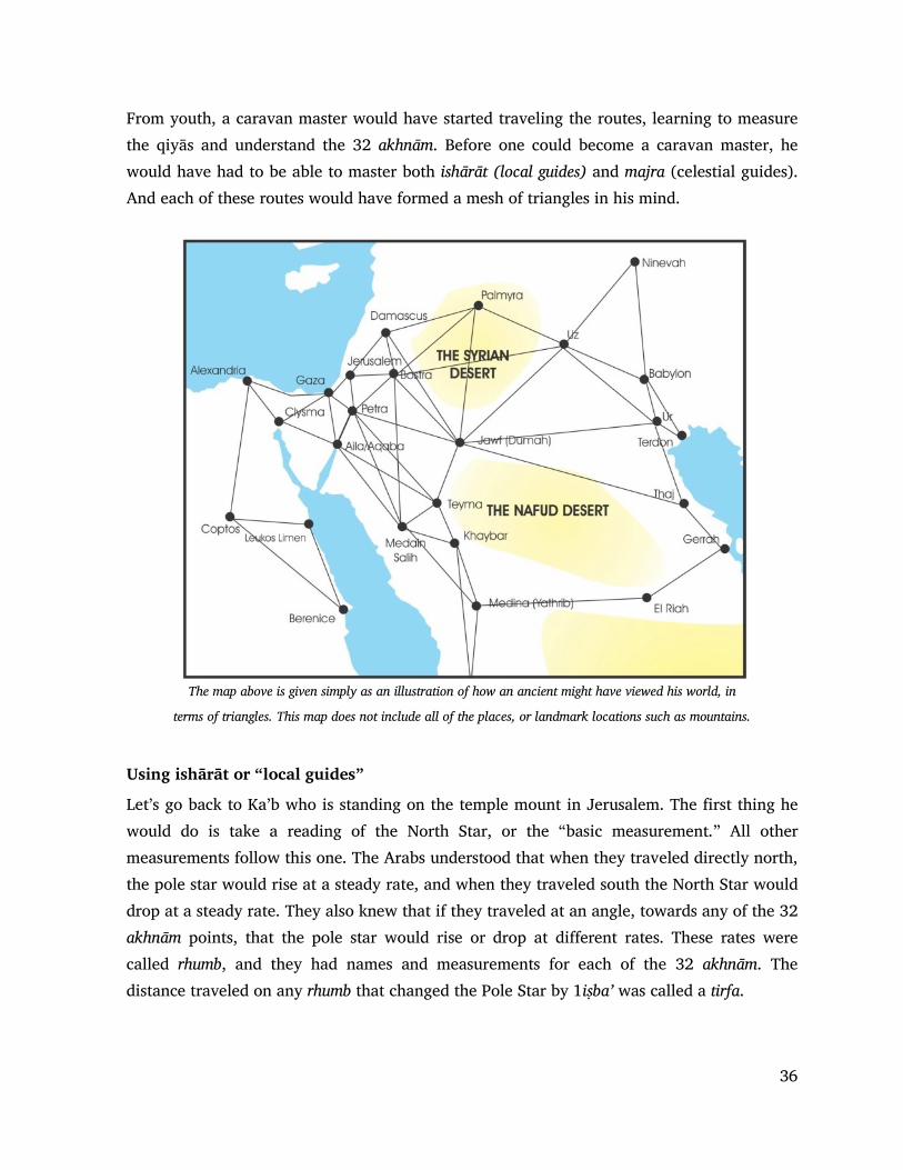
36
From youth, a caravan master would have started traveling the routes, learning to measure the qiyās and understand the 32 akhnām. Before one could become a caravan master, he would have had to be able to master both ishārāt (local guides) and majra (celestial guides). And each of these routes would have formed a mesh of triangles in his mind.
The map above is given simply as an illustration of how an ancient might have viewed his world, in
terms of triangles. This map does not include all of the places, or landmark locations such as mountains.
Using ishārāt or “local guides”
Let’s go back to Ka’b who is standing on the temple mount in Jerusalem. The first thing he would do is take a reading of the North Star, or the “basic measurement.” All other measurements follow this one. The Arabs understood that when they traveled directly north, the pole star would rise at a steady rate, and when they traveled south the North Star would drop at a steady rate. They also knew that if they traveled at an angle, towards any of the 32 akhnām points, that the pole star would rise or drop at different rates. These rates were called rhumb, and they had names and measurements for each of the 32 akhnām. The distance traveled on any rhumb that changed the Pole Star by 1iṣba’ was called a tirfa.
37
Remember, caravan masters were not trying to map the world. They did not care about longitude and latitude. They had one objective: to find their way across trackless deserts towards a city or watering point that was over the horizon.
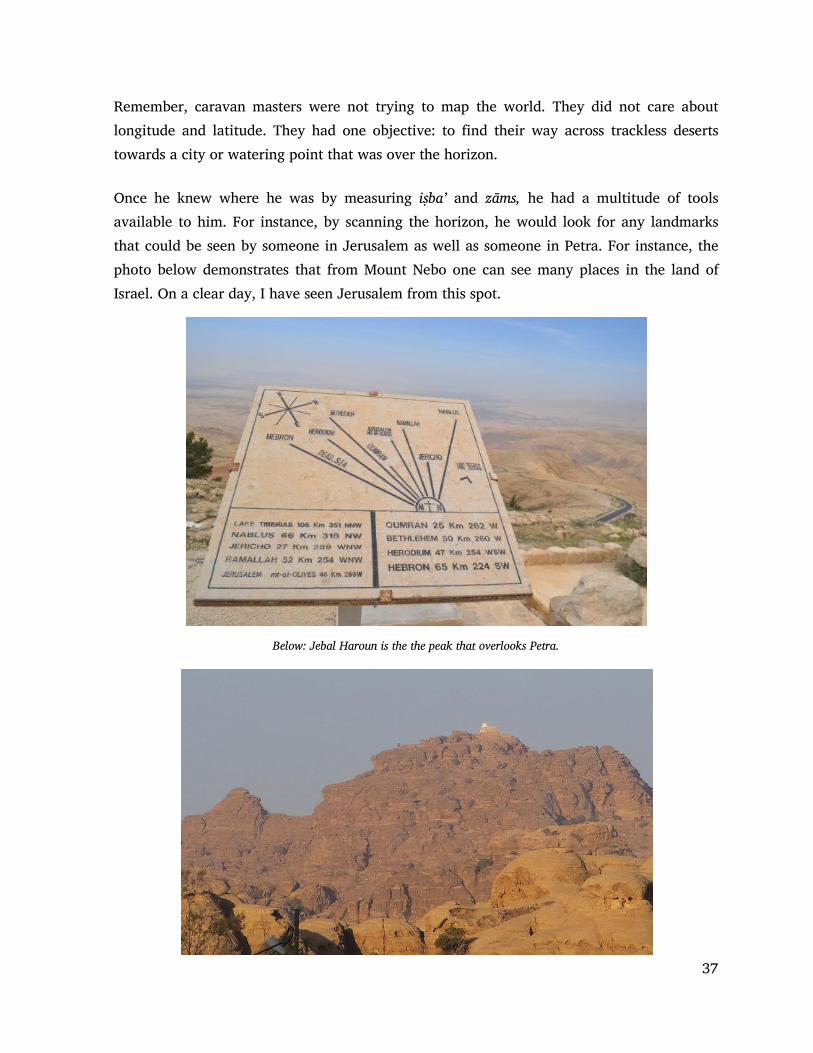
Once he knew where he was by measuring iṣba’ and zāms, he had a multitude of tools available to him. For instance, by scanning the horizon, he would look for any landmarks that could be seen by someone in Jerusalem as well as someone in Petra. For instance, the photo below demonstrates that from Mount Nebo one can see many places in the land of Israel. On a clear day, I have seen Jerusalem from this spot.
Below: Jebal Haroun is the the peak that overlooks Petra.

38
While Ka’b could not see Petra he could see as far as the Judean mountains. And he could map the southern horizon using the stars on the Arab Rose compass, noting which stars were nearest the peaks. From the ancient city of Petra observers would have known the main geographical features around them on the distant horizon. Ka’b, who was skilled in navigation, would have known this from his observations while in the Holy City.
By comparing the two horizons, Ka’b would have pointed his Qibla at the mountain or valley that was closest to what could be observed from the south. Another option would have been to take the reading from other points within a known walking distance from Petra and then calculating the central point using the Pythagorean theorem.

39
Below we can see a mountain peak in the south Judean desert which can be viewed from very far away as it overlooks the Dead Sea valley, and can be seen from the Mountains of Moab as well as from Jerusalem some 47 km away. If a person stands on top a mountain, he can survey a larger-than-usual patch of the planet, and can perceive bright lights from a great distance. On a dark night, a person can see a candle flame flickering up to 48 kilometers away (30 miles). Back in the time of the Nabataean merchants, there was no light pollution from cities, so a bright light on a mountain top could be seen over a hundred miles away. The Romans used lights on mountain peaks as part of the Cursus Publicus system to send messages to and from Rome.
This system consisted of a series of forts and stations that were spread out along the major road systems connecting the regions of the Roman world. These stations provided horses to dispatch riders, usually soldiers, and vehicles for magistrates or officers of the court. The vehicles were called clabulae, but little is known of them. A written order issued by the emperor himself was necessary to use the services supplied by the cursus publicus. Abuses of

40
the system existed, for governors and minor appointees used the orders to give themselves and their families free transport. Forgeries and stolen orders were also used. Pliny and Trajan write about the necessity of those who wish to send things via the imperial post to keep up-to-date licenses.43 This system also incorporated beacon lights that could be used for important messages. These beacons were used where the terrain made traditional travel slow. While most travel went along the Roman roads, the beacons could be used for emergency messages. Jerusalem was such a location, where beacons could be viewed from Machaerus some 45 kilometers away (see photo below). The road required travel around the Dead Sea, but a beacon from the mountain-top palace could easily be seen in Jerusalem. The angle of direction from Jerusalem to Machaerus would have been known, as well as the iṣba’ height between them. While there is no record of a similar beacon being set up on mount Haroun above Petra, it would be surprising if there was no beacon, since the daughter of King Aretas of Petra was the wife of King Herod. The beacon system allowed the kingdoms around the Dead Sea to communicate with the Roman rulers in Jerusalem, as well as to access the Roman cursus publicus that took messages from Jerusalem to Rome.
Above: Herod’s palace known as Machaerusm across the Dead Sea from Jerusalem.
Often we think that the locations in the Middle East were remote and unknown to each other. However, these neighboring centers of power were well known to each other, and merchants could make their way from one centre to another with little trouble. 43. E.g. Trajan to Pliny X 46 Diplomata, quorum praeteritus est dies, non debent esse in usu. Ideo inter prima iniungo
mihi, ut per omnes provincias ante mittam nova diplomata, quam desiderari possint.

41
Basic Information In addition to using ishārāt or “local guides” ancient navigators could also use the stars and a bit of math. There are several ways this could be done. First, Arabs often used a right triangle. In the example below, Ka’b would know the iṣba’ height of the north pole star at Petra, the central city of Islam. He would measure this in ’iṣba and zāms.

42
The Portolan Method
While there is some mystery around the origin of Portolan maps, I believe evidence supports the theory that they originated from the Arabs and arrived in Europe, appearing first in Pisa around 1290. Portolan maps rely heavily on the Arab compass and on rhumb lines. Using the Arab compass, Ka’b could calculate the angle south from Jerusalem and the corresponding angle north from Petra. These opposite corresponding rhumb lines are the foundation to understanding the Arab system of navigation. North-South measurements were made both by measuring the height of the North Star, and also counting steps. Measurements east-west relied strongly on counting steps or using time. However, if the navigator knew he had followed a rhumb line according to one of the stars, he could easily calculate how far he had to walk to reach his destination.
Above: The problem of finding the qibla angle to Petra when in Jerusalem. Right: An Arabic Rose compass placed over each location identifies that the angles follow al
Sulbār from Jerusalem and al Farqadān
from Petra.

43
This method of calculation was the foundation of the Portolan maps system. Arab navigators were very familiar with the horizon and the place where stars rose and set at each of their destinations. Therefore they would think in terms of the Arab Compass over each of the locations they visited.
Pigeons Another option that could have been used is that of homing pigeons. Below is a photo of what has been called the columbarium at Petra. A columbarium is a place with niches for funeral urns to be stored. Several websites infer that this was the use for this location. However, there is no record of Nabataeans ever cremating the bodies of their dead. Rather, the evidence points to exposing the dead on platforms and then burying the bones. These bones were placed in family tombs which were accompanied by dining rooms where the extended family could gather at pilgrimage time to eat a meal in the presence of the ancient ancestors.
Left: The so-called columbarium in Petra. This type of rock carved formation is not unique to Petra. It is found in many ancient locations, and is not associated with death or burial rites in other locations.
Right: a similar rock located in Wadi Seir near the Iraq al-Amir castle. Both of these sites appear to be dovecotes for homing pigeons as do similar rock desgns in the caves at Bet Guvrin National Park and elsewhere.
As a method of communication, records go back to the ancient Persians from whom the art of training birds probably came. The Mughals also used them as their messengers, and the Romans used pigeon messengers to aid their military. Frontinus said that Julius Caesar used pigeons as messengers in his conquest of Gaul.44 44. Levi, Wendell (1977). The Pigeon. Sumter, South Carolina: Levi Publishing Co, Inc

44
The Arabs also kept pigeons and used them as messengers. There are records of pigeons being used in Baghdad for mail service soon after the founding of Islam.45
Flights as long as 1,800 km (1,100 miles) have been recorded by birds in competitive pigeon racing. This would put all of Syria, Iraq and Iran within flying range of Petra. Their average flying speed over moderate distances is around 140 km/h (86 miles per hour) but speeds of up to 160 km/h (99 miles per hour)have been observed in top racers for short distances.46
The Forbidden Sanctuary at Petra had pigeons. We know this from the writings of Al Tabari: “The horse of one of them began to drop dung and the pigeons of the sanctuary (al-ḥaram) area started to scavenge in the droppings. Al-Husayn reigned back his horse from them and Ibn al-Zubayr said ‘What is the matter with you?” He replied “I am afraid lest my horse kill the pigeons of the sanctuary area.” Ibn al-Zubayr said, “You would refrain from this sin, and yet you wish to kill Muslims?” Al-Husayn answered “I will not fight you, allow us to perform the ritual circumambulation of the sanctuary (al-bayt) and then we will leave you.” He did so, and they departed.”47
In personal correspondence with Dr. Richard Holland of the School of Biological Sciences at Bangor University in the UK, he stated that “Some studies suggest they know where to go immediately after release. It is difficult to measure the accuracy of their compass mechanism but the dominant one during the day is the sun compass and this is thought to be very accurate. More recent GPS tracking has shown that with repeated released from the same place pigeons recapitulate the route very accurately. The challenge in relying on the release of a single pigeon is that other factors could influence its behaviour, and so only by releasing a number of pigeons and assessing their mean heading do we see the pattern that they are oriented towards the home site. A flock released together might be less distracted but I am not sure of any research directly testing this.”
So it is possible that Qiblas were set without any science or math, just by transporting a number of homing pigeons from Petra, and releasing them at the construction site a few at a time until an accurate direction could be established. 45. Blechman, Andrew (2007). Pigeons-The fascinating saga of the world's most revered and reviled bird. St Lucia,
Queensland: University of Queensland Press 46. Walcott, Charles (1996). "Pigeon Homing: Observations, Experiments and Confusions" (Pdf article). Journal
of Experimental Biology. 199 (Pt 1): 21–27. PMID 9317262. Retrieved 2008-01-04. 47. Al Tabari Volume XX, 430, pg 2

45
Mathematical Solutions Many people fail to appreciate how early in history the concepts of mathematics were developed. Mathematical solutions were sought after by the ancient Egyptians, Greeks, Babylonians, as well as by others. For instance, the early study of triangles and basic trigonometry can be traced to the 2nd millennium BC in Egyptian mathematics in the Rhind Mathematical Papyrus and to Babylonian in clay tables such as tablet YBC 7289.
Left: The Yale Babylonian Collection's Tablet, YBC 7289 (c. 1800–1600 BCE), showing a Babylonian approximation to the square root of 2 (1 24 51 10 w: sexagesimal) in the context of Pythagoras' Theorem for an isosceles triangle. Courtesy of: Bill Casselman, http://www.math .ubc.ca/~cass/Euclid/ybc/ybc.html) and the Yale Babylonian Collection.
Systematic study of trigonometric functions began in Hellenistic mathematics, reaching India as part of Hellenistic astronomy. In Indian astronomy, the study of trigonometric functions flourished in the Gupta period, especially in sixth century CE. During the Middle Ages, the study of trigonometry continued in Islamic mathematics, hence it was adopted as a separate subject in the Latin West beginning in the Renaissance with Regiomontanus. The development of modern trigonometry shifted during the western Age of Enlightenment, beginning with 17th-century mathematics (Isaac Newton and James Stirling) and reaching its modern form with Leonhard Euler (1748).
The ancient Babylonians had known of theorems on the ratios of the sides of similar triangles for many centuries, but they lacked the concept of an angle measure and consequently, studied the sides of triangles instead48 These Babylonian astronomers kept detailed records on the rising and setting of stars, the motion of the planets, and the solar and lunar eclipses, all of which required familiarity with angular distances measured on the celestial sphere.49
48 Boyer, Carl Benjamin, Greek Trigonometry and Mensuration, in A History of Mathematics, 1991, pp. 158–159 49 Maor, Eli, Trigonometric Delights. Princeton University Press, 1998, p. 20

46
They also used a form of Fourier analysis to compute ephemeris (tables of astronomical positions), which was discovered in the 1950s by Otto Neugebauer.49 To make calculations of the movements of celestial bodies, the Babylonians used basic arithmetic and a coordinate system based on the ecliptic, the part of the heavens that the sun and planets travel through. Research published in 2016 by Mathieu Ossendrijver based on tablets found in the British Museum provides evidence that the Babylonians even went so far as to have a concept of objects in an abstract mathematical space. The tablets date from between 350 and 50 B.C.E., revealing that the Babylonians understood and used geometry even earlier than previously thought. Ossendrijver showed that the Babylonians used a method for estimating the area under a curve by drawing a trapezoid underneath, a technique previously believed to have originated in 14th century Europe. This method of estimation allowed them to, for example, find the distance Jupiter had traveled in a certain amount of time. 50 Thus it comes as no surprise that six hundred years later, the Arabs of Muhammad’s time had access to the basic concepts of spherical trigonometry which deals with the relationships between trigonometric functions of the sides and angles of the spherical polygons (especially spherical triangles) defined by a number of intersecting great circles on the sphere. Spherical trigonometry is of great importance for calculations in astronomy, geodesy and navigation. The outside circle of numbers on the Arab compass demonstrate that the Arabs had access to spherical trigonometry and used it regularly. The Arabs of the ninth to fifteenth centuries would become the world leaders in algebra which simplified trigonometry. However, as time passed, the earlier methods of establishing the Qibla direction were lost. leaving us to wonder, exactly how the early Muslims could have calculated their qiblas so accurately. 49 Boyer PP 158 - 215 50 Emspak, Jesse. "Babylonians Were Using Geometry Centuries Earlier Than Thought". Smithsonian. Retrieved 2016-02-01.

47
The Qibla From the materials presented in this paper I have attempted to demonstrate that during the time of the founding of Islam, the Arabs would have had many tools and techniques available to them, so that they could accurately determine the direction of the Qibla for their mosques. They could use two methods, that of ishārāt or the knowledge of guides and aids, such as mountains, valleys, and rock formations as well as majra, or taking celestial bearings and using mathematical solutions. They measured distance in zāms calculating distance both from measuring the stars as well as from physically walking and counting steps. Along with this, they had the Arab Compass which provided them with a sense of angles, measured against the stars, as well as corresponding stars at the other end of the same tangent. they also had an understanding of basics formulas for spherical trigonometry. With this knowledge, it comes as no surprise that the Qiblas of early mosques all over the ancient world are accurate to within several degrees. As we demonstrated in the first paper, the first Qiblas all pointed to Petra. Then in 708 AD (75 years after the death of Muḥammad) the mihrab mark was introduced so that people could pray towards the Black Stone in Mecca rather than the Holy City of Petra. Finally, after the Abbāsid rulers solidified their control over the Muslim empire, all mosques and Qiblas pointed towards Mecca in Saudi Arabia.

48
Bibliography
This is a partial bibliography that contains references for this paper, and some for forth coming papers. It will grow in size as each paper is released in the future, and each release will replace the bibliography of the previous paper. The bibliography in the final collection will be considered the full bibliography. Al Farāhīdi - Abū ’Abd al Raḥmān Khalīl ibn Aḥmad al Farāhīdi (More commonly known as Al Farāhīdi) (718 AD– 791 AD) Kitāb al-’Ayn Aḥmad, S. Islamic Education. New Dheli: Anmol Publication PVT. Ltd. 2004 Aḥmad b. Mājid al-Najdī Kitāb al-Fawā’id fī usūl al-baḥr wa’l-qawā’id Translated by G. R. Tibbetts in Arab Navigation, 1981
Blechman, Andrew (2007). Pigeons-The fascinating saga of the world's most revered and reviled bird. St Lucia, Queensland: University of Queensland Press
Bonadona, F, Holland, R, Dall'Antonia, L, Guilford, T & Benvenuti, S 2000, 'Tracking clock-shifted homing pigeons from familiar release sites' Journal of Experimental Biology, vol 203, no. 2, pp. 207-212. Bosworth, Clifford Edmund. The Encyclopaedia of Islam, 227-229. Leiden: Brill, 1997 Bosworth, Clifford Edmund. The new Islamic dynasties: a chronological and genealogical manual, 93. New York: Columbia University Press, 1996 Boyer, Carl Benjamin, Greek Trigonometry and Mensuration, in A History of Mathematics, 1991 Continuatio Byzantia-Arabica or Chron. Byz.-Amb 741 = J. Gil, eel. Corpus scriptorum Muzambicorum I (Madrid, 1973), 7-14; Enrique Florez, ed. Espana sagrada, vol. 6 (Madrid, 1751), 422-32 (Appendix X); T. Mommsen, eel. Continuatio Byzantia Arabica ad annumDCCXLI (MGH auctores antiquissimi 11.2 chmnica minora saeculi IV- VII; Berlin, 1894), 334-59. This text is translated in Excursus B above. Chron. Hisp. 754 = J. Gil, ed. Co·rpus scriptorum Mu:::arabicorum I (Madrid)

49
Constable, Anthony R., Facey, William The Principles of Arab Navigation, AP Publishing, 2013 Emspak, Jesse. "Babylonians Were Using Geometry Centuries Earlier Than Thought". Smithsonian. Retrieved 2016-02-01. Facey, W. (1991) Oman, a seafaring nation. Sultanate of Oman: Ministry of National Heritage and Culture Hagmann, Carl, and Cook, Robert G., . Active Change Detection by Pigeons and Humans, Journal of Experimental Psychology: Animal, Behavior Processes, July 22, 2013. Hill, J. E. (2003, September) The Western Regions according to the Hou Hanshu, The Xiyu juan, “Chapter on the Western Regions,” from Hou Hanshu 88. Retrieved March 31, 2010, from http://depts.washington.edu/silkroad/texts/hhshu/hou_han_shu.html Hourani, A. (1991) A History of the Arab Peoples. Cambridge, Massachusetts: The Belka Press of Harvard University Ibn Baṭṭūṭa, pg. 85. Ibn al-Faqīh, pg. 159. Ibn Khallikān, Wafayāt al-A῾yān wa Anbā᾽ Abnā᾽ al-Zamān, ed. by Iḥsān ῾Abbās, 8 vols Beirut: Dār Ṣādir, 1969, II, 223; Ibn Mājah ḥadīth Ibn Zubāla, Akhbār Al-Madīna, Arabic 199 AH King, D. A., ḳibla, Encyclopedia of Islam, Vol 5, page 82-88, Leiden, E. J. Brill, 1986 Levi, Wendell (1977). The Pigeon. Sumter, South Carolina: Levi Publishing Co, Inc Madelung, W., Karmati, Encyclopedia of Islam, Vol IV, Brill, 1997, page 662

50
Maor, Eli, Trigonometric Delights. Princeton University Press, 1998 McDonald, M. V. (1978) “Orally Transmitted Poetry in Pre-Islamic Arabia and Other Pre-Literate Societies” Journal of Arabic Literature, Vol 9, pp. 14-31. Moreh, S. (1976) Modern Arabic poetry 1800-1970: The development of its forms and themes under the influence of Western literature. Netherlands: Brill Morrison, J. E. (1996, July 5) Astrolabe History. Retrieved 11 April, 2010, from http://www.astrolabes.org/history.htm Needham, J. Science and Civilisation in China, Volume 3. Cambridge: Cambridge at the University Press, 1959 Nicholson, R. A. Literary History of the Arabs. Surrey, UK: Cambridge, University Press, 1993 Pliny XII, Chap. XIII Natural History 12.32.65 Seidelmann, P. Kenneth "Phases of the Moon". Explanatory Supplement to the Astronomical Almanac. University Science Books. p. 478 2005 Syed Ahmad Iskandar Architectural Conservation in Islam, Case Study of the Prophet’s Mosque, Syed Ariffin, Penerbit, Universiti teknologi Malaysia, skudai, Johor Darul Ta’sim, 2005 Shaikh Naṣr bin ’Alī al Haḍuri Kitāb ma’din al-asrār fi ’ilm al-biḥār (The Mine of Secrets in the Science of the Seas) Stephenson, F. Richard and Said S. Said , Records of Lunar Eclipses in Medieval Arabic Chronicles, Bulletin of the School of Oriental and African Studies, University of London, Vol. 60, No. 1, 1997, pp. 1-34 Ṭabarī, History of Prophets and Kings, Volume XII, translated by Yohanan Friedmann Tibbetts, G. R. Arab Navigation, 1981 which includes: Aḥmad b. Mājid al-Najdī by Kitāb al-Fawā’idfī usūl al-baḥr wa’l-qawā’id

51
Al-Tirmidhī, ḥadīth. See also al-Samhūdī, Wafā᾽, I, 338. This ḥadīth is regarded as ḥasan by Ibn Rajab, III, pg. 300-2
Walcott, Charles (1996). "Pigeon Homing: Observations, Experiments and Confusions" (Pdf article). Journal of Experimental Biology. 199 (Pt 1): 21–27. PMID 9317262. Retrieved 2008-01-04