Embed Size (px)
Citation preview
COUNCIL ASSESSMENT PANEL MEETING
12 August 2020
AGENDA – 9.2
Applicant: Robert Butler
Landowner: R J Butler & A C Butler
Agent: Geoff van Senden Originating Officer: Doug Samardzija
Development Application:
20/100/473
20/D005/473
Application Description: Land Division - Boundary realignment (3 into 3)
Subject Land:
Lot:3 Sec: P130 FP:9293 CT:5490/809
Lot:4 Sec: P130 FP:9293 CT:5493/580
Lot:1 Sec: P130 FP:4140 CT:5142/149
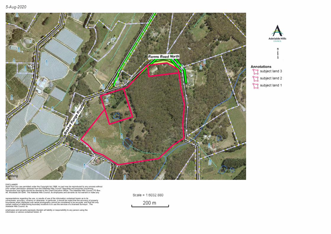
General Location: 30 Ranns Road North, Lot 4
Ranns Road North & 166 Basket Range Road
Basket Range SA 5138
Attachment – Locality Plan
Development Plan Consolidated : 08 August
2019
Maps AdHi/1, 3 & 64
Zone/Policy Area: Watershed (Primary
Production) Zone - Water Protection (Marble Hill)
Policy Area
Form of Development:
Merit
Site Area: 20.34 hectares (total combined size of 3
allotments)
Public Notice Category: Category 1 Merit -
Land Division
Representations Received: N/A
Representations to be Heard: N/A
1. EXECUTIVE SUMMARY
The purpose of this application is to realign the boundaries of three allotments.
The subject land is located within the Watershed (Primary Production) Zone - Water Protection
(Marble Hill) Policy Area.
The proposal is a merit, Category 1 form of development.
As per the CAP delegations, the CAP is the relevant authority because the allotments are in the
Watershed (Primary Production) Zone, and the realignment involves three allotments with one
of the proposed resulting allotments to have an area less than 2 hectares, and the other two
remaining allotments to have respective areas of 7.2 hectares and 12.1 hectares in area.
The purpose of the proposal is to realign the allotment boundaries to consolidate the native
vegetation land onto proposed allotment 200, all the arable land onto proposed allotment 202
and a smaller allotment around the existing dwelling and associated structures on proposed
allotment 201.
The main issues relating to the proposal are impacts on the primary production land, creation of a
rural living allotment and impacts on native vegetation.
In consideration of all the information presented, and following an assessment against the
relevant zone and Council Wide provisions within the Development Plan, staff are recommending
that the proposal be GRANTED Development Plan Consent, subject to conditions.
Council Assessment Panel Meeting – 12 August 2020
Robert Butler
20/100/473 2
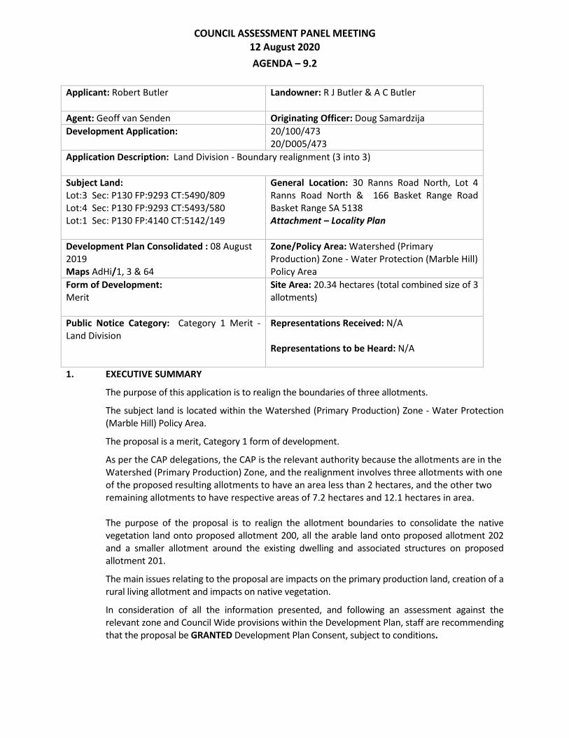
2. DESCRIPTION OF THE PROPOSAL
The proposal is for boundary realignment involving three allotments.
Existing Allotments
Allotment Area (ha) Currently containing
1 2.104ha Single storey dwelling, associated domestic
outbuildings and a small dam
3 0.87ha Single storey dwelling and associated domestic
outbuildings
4 17.37ha Vacant allotment with approximately half of the
allotment used for grazing purposes and
containing a dam and water course whilst the
other half contains dense native vegetation
Proposed Allotments
Allotment Area (ha) Containing
200 12.1ha Single storey dwelling, associated domestic
outbuildings and dense native vegetation
201 1.1ha Single storey dwelling and associated domestic
outbuildings
202 7.2ha Vacant primary production land, associated dam
and water course
The plan of division includes:
The outline of existing structures on the subject properties as well as other site features
such as a dams and native vegetation. A further aerial image has a more detailed layout
of proposed allotment boundaries in relation to existing structures and natural land
features.
The location of rights of way marked A have also been included in the proposal. The
proposed right of way in the south/eastern corner of allotment 202 is required to give
access to the southern portion of allotment 200 off Nicols Rd. Similarly with the
proposed right of way adjacent to portion of the western side boundary of allotment 200
with this right of way covering an existing track which also provides access to the
southern portion of allotment 200. Ranns Rd North, adjacent to the eastern boundary of
allotment 200, is an unmade public road and not trafficable.
The proposed plans are included as Attachment – Proposal Plans with other information
included as Attachment – Application Information and
Council Assessment Panel Meeting – 12 August 2020
Robert Butler
20/100/473 3
3. BACKGROUND AND HISTORY
Whilst Council does not have any records of previous approvals on the subject land,
examinations of aerial photos reveals that the structures were built between 1949 and 1986
whilst the native vegetation appears largely unchanged since 1949.
4. REFERRAL RESPONSES
CFS
The CFS have no objection to the proposal and have only commented on proposed lot
202 which is the only vacant allotment with potential for future residential use. No
comments were made in relation to existing dwellings.
SA WATER
SA Water did not have any comments to provide. There is no mains water or sewer
infrastructure.
NVC
Providing any future development is undertaken in existing cleared areas, the NVC does
not object to the proposal. Any new boundary fence (where there is no fence existing)
should be placed at least 5m from remnant vegetation so as to protect that vegetation
from clearance for a new fence line. Any proposal to clear native vegetation, unless
subject to an exemption under the Native Vegetation Regulations, requires NVC
approval (Refer to Council Land Division Statement of Requirements condition 1).
SCAP
Standard response was provided by SCAP requiring a final survey plan (refer SCAP
condition 1).
RATES
No changes to the current numbering.
AHC ENGINEERING DEPARTMENT
Council’s Engineering Department reviewed the proposed right of way access along the
southern boundary of proposed lot 202 and advised that they have no concerns
provided CFS has no objections. In addition it was stated that consideration of
stormwater will be required when the access is formalised, as a piped crossover will
likely be required to collect and transfer stormwater from the road. (Refer to Council
Land Division Statement of Requirements condition 2)
The above responses are included as Attachment – Referral Responses.
5. CONSULTATION
The application was categorised as a Category 1 form of development not requiring formal
public notification.
The applicant or his representative – Geoff van Senden, may be in attendance.
Council Assessment Panel Meeting – 12 August 2020
Robert Butler
20/100/473 4
6. PLANNING & TECHNICAL CONSIDERATIONS
This application has been evaluated in accordance with the following matters:
i. The Site’s Physical Characteristics
The subject land is comprised of three allotments with a combined area of 20.34
hectares. Existing lot 1 is a rectangular shaped allotment of approximately 2.104
hectares. This allotment has a frontage of 130m and direct access to Basket Range
Road. This allotment contains a single storey dwelling, associated domestic structures
and a dam. The front area of the allotment where the dwelling is located is flat but
then remainder of the allotment slopes down from a high point in the north to a low
point in the south.
Existing lot 3 is irregular in shape with an area of 0.87 hectares and similar to
allotment 1 it contains a single storey dwelling and associated domestic structures.
This allotment has a direct frontage and access to Ranns Road North. The allotment is
located on the higher side of the road with the allotment sloping west to east.
Existing lot 4 is an irregular undulating allotment with a duel road frontage to Ranns
Road North and Nicols Road. This allotment is vacant with the western side of the
allotment along Nicols Rd used for grazing purposes whilst the north eastern side of
the allotment contains dense native vegetation.
ii. The Surrounding Area
The locality is characterised by a mixture of allotment sizes and uses. Allotments in
the immediate locality vary in size from 35 hectares to 4200m². Larger allotments
are predominantly used for primary production purposes and the smaller allotments
are used for rural living purposes.
Properties immediately to the west of the subject land are used primarily for primary
production purposes with the majority of these properties containing permanent
environmental covers associated with primary production use. Allotments
immediately to the east of the subject land whilst being large holdings are
predominantly used for rural living whilst also containing dense native vegetation.
iii. Development Plan Policy considerations
a) Policy Area/Zone Provisions
The subject land lies within the Watershed (Primary Production) Zone - Water
Protection (Marble Hill) Policy Area and these provisions seek:
Policy Area
- Restricted residential development on existing allotments only , provided water
resources are protected
- No intensification of urban development
Council Assessment Panel Meeting – 12 August 2020
Robert Butler
20/100/473 5
The following are considered to be the relevant Policy Area provisions:
Objectives: 3 & 4
PDCs: 7
Objective 3 seeks that residential development is restricted to existing allotments
and objective 4 seeks that there is no intensification of urban development. Whilst
the proposed boundary realignment does not involve any form of building work, the
objectives seek to ensure that any form of land division does not jeopardise the rural
setting. The proposed boundary realignment is considered to comply with the intent
of the objectives 3 and 4. Whilst the proposal does include a creation of a rural living
allotment less than 2 hectares in size, the proposal is not creating an additional rural
living allotment because it is simply swapping one rural living allotment for another.
As such it is not considered that this realignment is contributing to intensification of
urban development. Considering that the proposal does not involve creation of an
additional allotment it is also considered to be consistent with objective 3 in that the
land division is maintaining the status quo of the current situation and will not
increase development potential.
PDC 7 of the Policy Area seeks that development should not prejudice primary
production within the locality. Whilst the realignment of the boundary will result in a
large rural allotment of 17.37 hectares being separated into an allotment of 12.1 and
7.2 hectares, the realignment will not prejudice the primary production capability of
the land. The western side of the allotment proposed as lot 202 will remain as grazing
land whilst the north eastern side of the allotment containing dense native
vegetation will be incorporated within the existing rural living allotment.
Watershed (Primary Production) Zone
- The enhancement of the Mount Lofty Ranges Watershed as a source of high
quality waters
- The long-term sustainability of rural production in the south Mount Lofty Ranges
- The preservation and restoration of remnant native vegetation in the south
Mount Lofty Ranges
The following are considered to be the relevant Zone provisions:
Objectives: 2, 3 & 4
PDCs: 16, 17, 18, 19, 20, 21, 22, 31, 33, 34, 42, 44 & 70
Form of Development
PDCs 16 and 17 as well as Objective 3 seek to ensure that primary production is not
prejudiced, and that land that is particularly suitable for primary production remains
available for this purpose. As mentioned earlier in the report, it is considered the
proposed realignment of the boundaries is not going to have any impacts on the use
of available primary production land for such purposes. As such it is considered that
the proposal is consistent with the PDCs 16 and 17 as well as Objective 3.
Land Division
PDC 70 is procedural relating to the non-complying development triggers in the zone.
Land division in Watershed (Primary Production) Zone is considered to be non-
complying application unless it is able to meet the following exemptions:
Council Assessment Panel Meeting – 12 August 2020
Robert Butler
20/100/473 6
Land Division where no additional allotments are created, either partly or wholly,
within the Watershed (Primary Production) Zone, and where the development of
the proposed allotments does not result in a greater risk of pollution of surface or
underground waters than would the development of the existing allotments, and
provided a suitable site for a detached dwelling is available such that the site and
the dwelling would comply with the criteria in Table AdHi/5.
As mentioned earlier in the report, proposed boundary realignment is considered to
be a merit form of development because it does not result in the creation of an
additional allotment. In addition the proposed realignment of boundaries will not
result in a greater risk of pollution of surface or underground water. It is also
considered that proposed lot 202, the only vacant allotment, is a suitable size which
would be able to meet Table AdHi/5 requirements for any future dwelling. The
second exemption relating to land division in Watershed (Primary Production) Zone is
not relevant in this instance as it does not relate to Caravan and Tourist Park Policy
Area.
Upon establishing the procedural matters of the application, PDCs 18, 19, 20, 21 & 22
relate directly to the circumstances under which land divisions in the zone would be
considered.
PDC 18 provides that land division should only occur where a site for a detached
dwelling which complies with the criteria detailed in Table AdHi/5 is available. Table
AdHi/5 is a non-complying development trigger in the Zone. The aim of PDC 18 is
therefore to ensure that resulting allotments are able to be developed with detached
dwellings that are not non-complying in nature. At the same time PDCs 19 and 21 are
similar in that they both seek that land division proposals do not result in an
increased pollution risk to water resources or cause the loss of productive primary
production land.
The Table Adhi/5 criteria sets out that detached dwellings must be:
Sited at least 25m away from watercourses; and
Connected to an approved wastewater system that is at least 50m from the
watercourse, on the slope gradient of no more than 1 in 5 and no less than 1.2m
depth to bedrock
Proposed lots 200 and 201 currently contain residential dwellings and each dwelling
is connected to the existing on site waste system as shown on the aerial locality plan
included with attachments. The waste systems as shown on the drawing will be
contained within the proposed allotment boundaries. Proposed lot 202 is the only
vacant allotment and whilst there was no request for the applicant to demonstrate
compliance with the above Table Adhi/5, considering the size of the allotment and
the separation distances from the water course and dams it is considered that there
is ample space available for a suitable site for future dwelling which could comply
with the requirements.
The proposal is therefore considered to be consistent with PDC 18, 19 and 21.
Council Assessment Panel Meeting – 12 August 2020
Robert Butler
20/100/473 7
PDC 20 provides guidance as to the circumstances where land division proposals are
appropriate in the zone. This PDC states that land division may be undertaken
provided no additional allotments are created and the purpose of the plan of division
is to provide a re-adjustment of boundaries to correct anomalies in the placement of
those boundaries with respect to location of existing buildings. Alternatively the
minor readjustment could be undertaken if it is facilitating improved management of
the land for primary production purposes and/or conservation of natural features.
The proposal is not considered to be a minor re-adjustment of allotment boundaries
nor is its purpose to correct any anomalies in the form of boundary encroachments.
The proposal is therefore not considered to be consistent with PDC 20 (a).
By consolidating part of the existing lot 4 which is covered entirely by native
vegetation with the existing homestead on current lot 3, and realigning the section of
land currently used for grazing purposes with the dam on the rear of existing lot 1, it
can be argued that the configuration of theses boundaries will allow for better
management and conservation of natural features. The realignment also retains the
primary production land, allowing for its future continuation and use. Therefore it
can be argued that the realignment is consistent with the intent of PDC 20 (b). The
consolidation of native vegetation into one single proposed lot 200 is also consistent
with Objective 4 of the zone which seeks preservation and restoration of remnant
native vegetation.
PDC 22 states that re-arrangement of allotment boundaries should produce
allotments of a size consistent with that of the locality. As mentioned earlier in the
report, allotments in the locality range from as large as 35 hectares to allotments as
small as 4200m². Whilst the proposal will still retain one rural living allotment under 2
hectares, it is in fact an improvement on the current situation with the existing rural
living allotment of 0.87 hectares being replaced by a new rural living allotment of 1.1
hectares which would make it the largest rural living allotment in the immediate
locality. The proposal is therefore considered to be consistent with PDC 22.
Conservation
PDC 31 seeks that land use does not change in or near native vegetation, whilst PDC
33 seeks that realignment of boundaries does not result in an increased number of
allotments adjoining an allotment with native vegetation. At the same time PDC 34
seeks that boundary realignment does not occur where it will increase the number of
allotments over areas covered by native vegetation. The proposed boundary
realignment will consolidate the majority of native vegetation within the single
proposed allotment 200. The realignment will not result in more allotments adjoining
native vegetation and as such it is consistent with PDC 33. By consolidating native
vegetation within one allotment, the proposed development is also consistent with
PDC 34. Whilst the realignment is not proposing any change of land use, PDC 31 is
still considered to be relevant to the proposed development. By separating part of
the existing allotment currently used for grazing purposes from the area of the
allotment containing native vegetation the proposal will ensure that any future use of
proposed lot 202 will not result in impacts on native vegetation.
Council Assessment Panel Meeting – 12 August 2020
Robert Butler
20/100/473 8
Rural Development
PDC 42 states that rural areas should be retained for primary production purposes
and other uses compatible with maintaining rural productivity. PDC 44 states that
development which would remove productive land from primary production or
diminish its overall productivity for primary production should not be undertaken
unless the land is required for essential public purposes. As mentioned earlier in the
report, the proposed realignment of boundaries is considered to maintain primary
production and is not considered to diminish the overall productivity of the land for
primary production. The proposal is therefore considered to be consistent with PDCs
42 and 44.
b) Council Wide provisions
The Council Wide provisions of relevance to this proposal seek (in summary):
- The retention of rural land in primary production especially land suitable for high
rates or fruit and vegetable production
- Development located to minimise the treat and impact of bushfires on life and
property while protecting natural and rural character
- Land division restricted in rural areas to ensure that efficient use of rural land for
primary production
- Retention, protection and restoration of the natural resources and environment
- Orderly and economic development that creates a safe, convenient and pleasant
environment in which to live in
Animal Keeping & Rural Development
Objectives: 1 & 2
PDCs: 1
Objectives 1 and 2 as well as PDC 1 seek that rural land should be retained for either
primary production and/or native vegetation conservation and retention purposes.
The proposed realignment is considered to achieve both of these requirements.
Proposed lot 201 whilst being of small size is not considered to be prejudicing
primary production land, nor is it contributing to the loss of native vegetation. The
existing dwelling and associated outbuildings will remain and any future development
on this site would be able to occur without any additional loss of vegetation.
Proposed lot 202 is of sufficient size to be retained for primary production use, whilst
lot 200 which would predominantly consist of dense native vegetation apart from
existing dwelling along the road, is considered to contribute to conservation and
retention of native vegetation. The Native Vegetation Council have not raised any
concerns with the proposed realignment and have advised that any new boundary
fence (where there is no fence existing) should be placed at least 5m from remnant
vegetation to protect that vegetation from clearance for a new fence line (refer to
Council Land Division Statement of Requirements condition 1). The applicant has also
advised that the existing fencing that is to form part of the new boundary between
proposed lot 200 and lot 201 was erected under the supervision of the 6th Creek
Catchment Group to keep stock out of the native vegetation. The fence is
predominantly complies with the 5 metre setback requirement and the boundary will
be adjusted if necessary to maintain this distance when the final survey is completed
Council Assessment Panel Meeting – 12 August 2020
Robert Butler
20/100/473 9
should approval be granted to the land division. (Refer to Council Land Division
Statement of Requirements condition 1)
Hazards
Objectives: 5
PDCs: 1, 6, 7 & 13
Objective 5 seeks that developments be located to minimise the threat and impact of
bushfire on life and property and this is reinforced by PDC 1. PDCs 6, 7 and 13 on the
other hand refer specifically to the Ministers Code: Undertaking Development in
Bushfire Protection Areas and seek that the measure in the Code can be met to
ensure any future habitable building is adequately protected in the event of the
bushfire. Whilst the proposed development does not include construction of
habitable buildings, the Development Plan still seeks that proposed division is able to
satisfy the necessary bushfire requirements for any potential future developments.
The CFS has undertaken the necessary assessment of the proposed division as
mentioned earlier in the report. The focus of the CFS assessment was solely on
proposed lot 202 as it is the only vacant allotment. CFS has advised that they have no
objections with the proposed application and have not identified any concerns with
the allotment being able to satisfy any of the Ministers Code requirements. As such it
is considered that the proposed development is consistent with Objective 5 and PDCs
1, 6, 7 and 13.
Land Division
Objectives: 2 & 5
PDCs: 1, 2, 5, 6, 7, 11, 21 & 22
The proposed division does not restrict existing rural living properties from continued
use as such, nor does it prevent the allotment from being redeveloped for such
purposes in the future. Each of the allotments has a direct access to a public road;
each of the existing dwellings is connected to an existing on site waste system whilst
proposed vacant allotment 202 has ample space to accommodate a future waste
system should the future land use be for other purposes other than primary
production. As such it is considered the proposal adequately satisfies Objective 2 and
PDCs 1, 2 and 6(c), 7.
PDCs 5 and 11 seek that land division be designed and configured so that it does not
impact on the native vegetation. As mentioned earlier in the report the proposed
realignment will not impact on any native vegetation. As such proposal is considered
consistent with PDCs 5 and 11.
Objective 5 seeks retention of efficient use of rural land for primary production
purposes and this is further enforced by PDCs 21 and 22 which seek that allotments
be retained for primary production purposes and that the natural resources are
protected. The proposed realignment of boundaries is not considered to impact on
the primary production use of the land. Existing allotment 4 has one section of land
which is capable of being used for primary production purposes whilst the rest of the
allotment contains native vegetation. The realignment of the allotment boundaries
will not alter this. Proposed lot 202 will still have the capability to be used for primary
Council Assessment Panel Meeting – 12 August 2020
Robert Butler
20/100/473 10
production purposes whilst being separated from the area of land which contains
native vegetation. As such it is considered to satisfy the intent of Objective 5 and
PDCs 21 and 22.
Natural Resources
Objectives: 1
PDCs: 1, 37, 38 & 39
Objective 1 and PDC 1 seek retention, protection and restoration of natural resources
and environment including water quality, land, soil and biodiversity. The proposed
realignment of boundaries achieves the requirements set out in Objective 1 and PDC
1. It will not result in an increase in development potential given that existing lot 4 is
vacant land with the option of future use other than primary production which might
require an on-site waste system. The proposed realignment of the boundaries does
not alter this aspect.
Similar to some of other PDCs discussed earlier in the report, PDCs 37, 38 and 39 put
an emphasis on protecting native vegetation and locally indigenous plant species. As
mentioned earlier in the report the proposed realignment will not impact upon or
result in the loss of native vegetation and is therefore considered to meet the
requirements set out in PDCs 37, 38 and 39.
Orderly and Sustainable Development
Objectives: 1, 4, 8, 9 & 10
PDCs: 1 & 2
Objective 1 seeks orderly and economic development whilst Objective 4 seeks
development which does not prejudice the achievements of the provision of the
Development Plan. The proposed development is seeking to realign the boundaries
of three existing contiguous allotments and will not result in the creation of a new
allotment in the Watershed (Primary production) Zone and is considered to be
sufficiently consistent with the provisions set out in the Development Plan.
Objectives 8, 9 and 10 as well as PDCs 1 and 2 seek the protection of rural areas,
surrounding watersheds and prevention of urban development from further
encroachment into rural areas. As mentioned earlier in the report, the proposed
realignment of boundaries does not prejudice primary production land and is not
resulting in creation of a new allotment within the watershed zone, nor is it
increasing development potential within the zone. The proposal is therefore
considered to be consistent with Objectives 8, 9 and 10 as well as PDCs 1 and 2.
7. SUMMARY & CONCLUSION
The proposal seeks consent to realign the boundaries of three allotments in the Watershed
(Primary Production) Zone and Water Protection (Marble Hill) Policy Area.
The purpose of the proposal is to realign the allotment boundaries to place predominantly all the
native vegetation land onto proposed allotment 200, all the arable land onto proposed allotment
202 and retain a smaller allotment around the existing dwelling and associated structures on
proposed allotment 201.
Council Assessment Panel Meeting – 12 August 2020
Robert Butler
20/100/473 11
It is considered that the proposed realignment is not going to prejudice any primary production
land with proposed lot 200 retaining its potential to be used for primary production purposes.
Furthermore the proposal improves the management of the land for primary production by
acquiring an arable section of existing allotment 1 and incorporating both of the dams into a
single allotment.
Native vegetation is retained and protected by being predominantly incorporated into a singular
allotment. Native Vegetation Council have not raised any concerns and have sought that any new
boundary fence (where there is no fence existing) should be placed at least 5m from remnant
vegetation so as to protect that vegetation from clearance for a new fence line.
The development of the proposed allotments does not result in a greater risk to water quality in
the watershed area. The two existing dwellings will be retained on their individual allotments and
the realignment will not further increase development potential in the watershed zone.
The proposal is therefore considered to be sufficiently consistent with the relevant provisions of
the Development Plan, and is not seriously at variance with the Development Plan. In the view of
staff, the proposal has sufficient merit to warrant consent. Staff therefore recommend that
Development Plan Consent be GRANTED, subject to conditions.
8. RECOMMENDATION
That the Council Assessment Panel considers that the proposal is not seriously at variance
with the relevant provisions of the Adelaide Hills Council Development Plan, and GRANTS
Development Plan Consent and Land Division Consent to Development Application
20/100/473 (20/D005/473) by Robert Butler for Land Division - Boundary realignment (3 into
3) at 30 Ranns Road North, Lot 4 Ranns Road North and 166 Basket Range Road, Basket
Range subject to the following conditions:
Planning Conditions
(1) Development In Accordance With The Plans
The development herein approved shall be undertaken in accordance with the
following plans, details and written submissions accompanying the application, unless
varied by a separate condition:
Plan of division prepared by Olden & van Senden, reference number 4103da V2
dated 29/10/2018
REASON: To ensure the proposed development is undertaken in accordance with the
approved plans.
Notes
(1) Development Plan Consent
This Development Plan Consent (DPC) is valid for a period of twelve (12) months
commencing from the date of the decision (or if an appeal has been commenced the
date on which it is determined, whichever is later). Building Rules Consent must be
applied for prior to the expiry of the DPC, or a fresh development application will be
Council Assessment Panel Meeting – 12 August 2020
Robert Butler
20/100/473 12
required. The twelve (12) month time period may be further extended by Council
agreement following written request and payment of the relevant fee.
(2) Department of Environment and Water (DEW) - Native Vegetation Council
The applicant is advised that any proposal to clear, remove limbs or trim native
vegetation on the land, unless the proposed clearance is subject to an exemption
under the Regulations of the Native Vegetation Act 1991, requires the approval of the
Native Vegetation Council. For further information visit:
www.environment.sa.gov.au/Conservation/Native_Vegetation/Managing_native_veg
etation
Any queries regarding the clearance of native vegetation should be directed to the
Native Vegetation Council Secretariat on 8303 9777. This must be sought prior to Full
Development Approval being granted by Council.
Council Land Division Statement of Requirements
(1) Prior To Section 51 Clearance- Survey Plan Showing Boundary Location
Prior to Section 51 clearance a final survey plan shall be provided to Council to
demonstrate that new boundaries are placed at least 5m from remnant vegetation.
REASON: Protect native vegetation from clearance for a new fence line.
(2) Prior To Section 51 Clearance- Rural Verge Piped Access Points - SD24
Prior to Section 51 clearance a vehicle access point(s) and cross over from Nicols Road
shall be constructed in accordance with Adelaide Hills Council standard engineering
detail SD24 – piped entrance.
REASON: For safe and convenient movement of vehicles and for efficient drainage of
stormwater within the road verge.
SCAP Land Division Statement of Requirements
(1) Requirement For Certified Survey Plan
A final plan complying with the requirements for plans as set out in the Manual of
Survey Practice Volume 1 (Plan Presentation and Guidelines) issued by the Registrar
General to be lodged with the State Commission Assessment Panel for Land Division
Certificate purposes.
REASON: Statutory requirement in accordance with Section 51 of the Development
Act 1993.
9. ATTACHMENTS
Locality Plan
Proposal Plans
Referral Responses

Council Assessment Panel Meeting – 12 August 2020
Robert Butler
20/100/473 13
Respectfully submitted Concurrence
___________________________ _______________________________
Doug Samardzija Deryn Atkinson
Statutory Planner Manager Development Services
Planning
DISCLAIMERApart from any use permitted under the Copyright Act 1968, no part may be reproduced by any process withoutprior written permission obtained from the Adelaide Hills Council. Requests and enquiries concerningreproduction and rights should be directed to the Chief Executive Officer, The Adelaide Hills Council, PO Box44, Woodside SA 5244. The Adelaide Hills Council, its employees and servants do not warrant or make any
representations regarding the use, or results of use of the information contained herein as to itscorrectness, accuracy, currency or otherwise. In particular, it should be noted that the accuracy of propertyboundaries when displayed over aerial photography cannot be considered to be accurate, and that the onlycertain method of determining boundary locations is to use the services of a licensed Surveyor . TheAdelaide Hills Council, its
employees and servants expressly disclaim all liability or responsibility to any person using theinformation or advice contained herein. ©

July 2, 2020
Governmentof South Australia
Land Services Group
Date created:Land Services GroupThe SA Property and Planning Atlas is available on the Land Services Group Website: www.sa.gov.au/landservices
The information provided above, is not represented to be accurate, current or complete at the time of printing this report. The Government of South Australia accepts no liability for the use of this data,or any reliance placed on it.
Disclaimer:
DEVELOPMENT ASSESSMENT SERVICE
Level 5, 60 Waymouth Street, Adelaide SA 5000
T 08 8463 4151 E [email protected]
ABN 97 677 077 835 www.cfs.sa.gov.au
Your Ref: 473/D005/20 Our Ref: Adelaide Hills DA
Please refer to: 20200224 – 02cs 24 February 2020 State Commission Assessment Panel GPO Box 1815 ADELAIDE SA 5001 ATTN: BILJANA PROKIC Dear Biljana RE: DEVELOPMENT APPLICATION (LAND DIVISION) – BUTLER LOT 4, RANNS ROAD NORTH, BASKET RANGE Please note that this assessment does not include allotments with already existing dwellings. The assessment is for proposed Lot 202 only.
Minister’s Code 2009 “Undertaking development in Bushfire Protection Areas” (as amended October 2012) [The Code] as published under Regulation 106 of the Development Regulations 2008 applies.
The Code, Part 2.1 states “When submitting an application it is important to remember that the information provided with an application forms the basis upon which the application will be assessed. If the information is inadequate or insufficient (incomplete, incorrect), the application may be delayed.”
An officer of the SA Country Fire Service [CFS] Development Assessment Service has assessed the proposed development site, allotment and adjoining areas.
A site bushfire attack assessment was conducted with reference to the National Construction Code of Australia [NCC], Australian Standard ™3959 [AS3959] “Construction of Buildings in Bushfire Prone Areas”
The proposed land division is located within an area that is categorized as a HIGH Bushfire Protection Area in the council development plan.
The SA Country Fire Service has no objection to the proposed boundary adjustment at Lot 4, Ranns Road North, Basket Range,to create 1 additional allotment for residential development.
ACCESS
Public access created by a land division to and from the proposed allotments shall be in accordance with the Minister’s Code 2009 “Undertaking development in Bushfire Protection Areas” (as amended October 2012), Part 2.2.2.
SA CFS notes no public roads are being created as a result of this land division.
CFS Mission To protect life, property and the environment from fire and other emergencies whilst protecting and supporting our personnel and continuously improving. Page 2 of 2
ACCESS TO DWELLINGS
Minister’s Code 2009 “Undertaking development in Bushfire Protection Areas” (as amended October
2012), Part 2.3.3.1, describes the mandatory provision that ‘Private’ roads and driveways to buildings
shall provide safe and convenient access/egress for large bushfire fighting vehicles, where the furthest
point to the building from the nearest public road is more than 30 metres.
Access on and off the allotments shall be in accordance with Minister’s Code 2009 “Undertaking development in Bushfire Protection Areas” (as amended October 2012), Part 2.3.3.1
WATER SUPPLY
A supply of water to the land division shall be available at all times for fire-fighting purposes. Ministers Specification SA78 prescribes the dedicated water supply to each allotment for bushfire fighting for the bushfire zone.
VEGETATION
Minister’s Code 2009 “Undertaking development in Bushfire Protection Areas” (as amended October
2012), Part 2.3.5 mandates that landscaping shall include Bushfire Protection features that will
prevent or inhibit the spread of bushfire and minimise the risk to life and/or damage to buildings and
property. .
- Individual applications for development consent for habitable buildings shall include mandatory conditions for a vegetation management zone to be established within 20 metres of proposed development.
BUILDING CONSIDERATIONS
Individual allotments undertaking applications for development consent will require a site bushfire attack assessment in accordance with the National Construction of Australia [NCC] and Australian Standard™3959 (AS3959) “Construction of Buildings in Bushfire Prone Areas”.
For construction requirements and performance provisions, refer to the NCC Part 3.7 “FIRE SAFETY” Australian Standard TM3959 (AS3959) “Construction of Buildings in Bushfire Prone Areas”.
Compliance with the fire protection requirements is not a guarantee the dwelling will not burn, but its intent is to provide a ‘measure of protection’ from the approach, impact and passing of a bushfire.
Should there be any need for further information please contact the undersigned at the SA CFS Development Assessment Service on (08) 8115 3372
Yours sincerely,
CAREN SIEGFRIEDT
BUSHFIRE SAFETY OFFICER
DEVELOPMENT ASSESSMENT SERVICE
Contact Planning Services Telephone 7109 7016 Email [email protected]
12 March 2020 Chief Executive Officer Adelaide Hills Council PO Box 44 WOODSIDE SA 5244 Dear Sir/Madam Re: Proposed Development Application No. 473/D005/20 (ID 67086)
for Land Division by Robert Butler
Further to my letter dated 3 February 2020 and to assist the Council in reaching a decision on this application, copies of consultation agency reports received by the State Commission Assessment Panel (SCAP) are available for your consideration. IT IS REQUESTED PURSUANT TO SECTION 33 (1) (c) OF THE DEVELOPMENT ACT 1993 THAT THE COUNCIL INCLUDE IN ITS DEVELOPMENT APPROVAL THE FOLLOWING REQUIREMENTS OF THE SCAP.
1. A final plan complying with the requirements for plans as set out in the Manual of Survey Practice Volume 1 (Plan Presentation and Guidelines) issued by the Registrar General to be lodged with the State Commission Assessment Panel for Land Division Certificate purposes.
SA Water Corporation has no requirements pursuant to the Development Act. Council’s particular attention is drawn to the comments by DEWNR - Native Vegetation Council for this application. Please upload the Decision Notification Form (via EDALA) following Council’s Decision. Yours faithfully,
Biljana Prokic LAND DIVISION COORDINATOR – PLANNING SERVICES as delegate of the STATE COMMISSION ASSESSMENT PANEL

03 February 2020
SA WaterLevel 6, 250 Victoria SquareADELAIDE SA 5000Ph (08) 7424 1119
Our Ref: H0094469 Inquiries Diana BaricTelephone 74241119
The ChairmanState Commission Assessment Panel50 Flinders StADELAIDE SA 5000Dear Sir/MadamPROPOSED LAND DIVISION APPLICATION NO: 473/D005/20 AT BASKET RANGEIn response to the abovementioned proposal, I advise that this Corporation has no requirementspursuant to Section 33 of the Development Act.No water or sewer infrastructure, boundary realignment only.Yours faithfullyDiana Baricfor MANAGER LAND DEVELOPMENT & CONNECTIONS