Embed Size (px)
Citation preview
Coupling a radial model of the Darcy-Forchheimer equation with a regional groundwater model to simulate drawdown at supply boreholes
Kirsty Upton1,2, Adrian Butler1, Chris Jackson2
1Imperial College London, [email protected], [email protected], London, UK 2British Geological Survey, [email protected], [email protected], Keyworth, Nottingham, UK
ABSTRACT
Assessing the short and long-term risks to a groundwater source is a critical part of water resource management. In the UK, public water supply companies apply the term Deployable Output (DO) to describe the yield of a groundwater source under drought conditions. DO is constrained by the physical properties of an aquifer and operational factors such as licence conditions, water quality, and pumping and treatment capacity. A robust assessment of groundwater DO should be informed by numerical modeling. This requires the groundwater level in a supply borehole to be accurately simulated within its regional hydrogeological context. A 3D radial flow model of the Darcy-Forchheimer equation is presented for simulating drawdown at a borehole. The Darcy-Forchheimer Radial Flow Model (DFRFM) represents linear and non-linear flows around the borehole; confined and unconfined conditions; vertical heterogeneity in the aquifer and borehole storage. The DFRFM is coupled with a regional groundwater model which represents the large-scale groundwater system, including lateral and vertical aquifer heterogeneity, rivers, and spatially varying recharge. The model has been applied to a supply borehole located in the dual permeability Chalk aquifer, which forms the principal aquifer in the UK and provides 40-70% of the total public water supply in southern and eastern England. The application demonstrates the potential for the coupled model to be used to inform DO assessments and to assess the long-term risk to sources under climate change scenarios.
INTRODUCTION
The management of an aquifer as a water resource requires a socially and environmentally acceptable balance to be maintained between supply and demand. In the UK, private water companies are legally required to produce a water resource management plan (WRMP) every 5 years outlining how they intend to achieve supply-demand balance over a 25-year period. To do this, they must be able to quantify the level of service to be provided to customers and the amount of water available. The total amount of water available for supply is assessed using the concept of Deployable Output (DO). DO describes the reliable output of a source, group of sources or water resources system for a specified level of service as constrained by the hydro(geo)logical properties of the source, surrounding environment, licensed quantity, water quality, and the capacity of the transfer and output mains. DO is evaluated under a dry year scenario to ensure the required levels of service can be maintained during drought. Water supply companies currently use operational data (pumping rates and groundwater levels at observation and pumping boreholes) to quantify the DO of individual groundwater sources. However, the availability and quality of data, particularly under drought conditions, is often limited. Recent guidelines outline the need for a more robust and flexible assessment framework to address the varying levels of complexity and vulnerability across a water resource zone (Environment Agency, 2012). In the new assessment framework, companies will be required to: (1) extend observed records at least back to 1920 to ensure important historic droughts are incorporated in assessments; (2) assess the potential impacts of climate change on the supply-demand balance, including an estimation of uncertainty, which should be accounted for in resource plans; (3) incorporate DO assessments at the catchment or resource zone scale, particularly where sources are used conjunctively, to ensure interdependencies between sources are accounted for and to enable a more integrated approach in the water resources planning process. To address these issues in a robust and integrated way, a modeling methodology is required that allows a groundwater system to be simulated accurately at both the catchment and borehole scale. A methodology is presented to allow the coupling of a small-scale radial model of a pumping borehole with a regional-scale groundwater model. The small-scale model represents the flow processes in and
MODFLOW and More 2013: Translating Science into Practice - Conference Proceedings, Maxwell, Hill, Zheng & Tonkin - igwmc.mines.edu
63
around a borehole, including the radial nature of flow, linear and non-linear losses and borehole storage. The borehole model is directly coupled to a Cartesian grid allowing it to be linked with a regional groundwater model, which encompasses the effects of neighboring boreholes, rivers, and spatially varying recharge. This linkage is achieved using the OpenMI standard (Moore et al., 2010). The methodology is described below, followed by a simple example of its application to a borehole in the dual permeability Chalk aquifer in the River Thames catchment, southern England.
METHOD Radial Flow Model
The Darcy-Forchheimer radial flow model (DFRFM) is based on a finite difference approximation to the 3D governing equation in cylindrical coordinates:
(1)
Where Ss is specific storage [L-1]; h is hydraulic head [L]; and N is an external source/sink term [T-1]. Nodes are logarithmically spaced along the radial axis allowing grid refinement around the borehole where the water table will have greater curvature. To account for the importance of non-linear losses in the borehole and surrounding formation, the specific discharge (qr) is calculated using the Forchheimer equation:
(2)
Where β is the turbulent flow coefficient [L-1T]; and K is hydraulic conductivity [LT-1]. A 1D finite difference approximation of the Forchheimer equation has previously been applied to simulate constant and variable rate pumping tests (Mathias & Todman, 2010). Its application for simulating step-test data has shown that a relationship can be derived between β and the non-linear well loss coefficient in Jacob’s solution. When β=0 equation 2 reduces to Darcy’s law. The vertical axis is discretized by a series of layers that can be parameterized to represent vertical heterogeneity in the aquifer. Layers can transition between confined, unconfined and dewatered depending on the elevation of head relative to the top and base of the layer. When a layer becomes unconfined, the storage and transmissivity are head-dependent and storage incorporates specific yield. When a layer dewaters it is disconnected from the grid and removed from the solution. The borehole is represented by a series of vertical nodes that are vertically connected and can be horizontally connected or disconnected with adjacent aquifer nodes depending on the absence or presence of borehole casing. All nodes within the borehole have a high vertical hydraulic conductivity to allow vertical flow within the borehole. Storage in the borehole is negligible, apart from the node representing the pump location which has storage equal to one. This is multiplied by the area of the borehole to represent borehole storage, which is particularly important at early times during a pumping test. Radial-Cartesian Coupling
Several multi-scale methods have been presented in the petroleum reservoir modeling literature for incorporating production wells in regional reservoir models. These include the hybrid radial-Cartesian method adopted in this study (Pedrosa Jr & Aziz, 1986) and finite volume methods based on two-point and multi-point flux approximations (Ding & Jeannin, 2004; Mundal et al., 2010). The hybrid radial-Cartesian method was selected over the more complex finite volume methods because of its simplicity, particularly in terms of grid generation, and accessibility to end-users who are likely to be hydrogeologists without significant modeling expertise. A Cartesian grid is constructed at an appropriate resolution for the regional flow system and one or more nodes are substituted with a DFRFM grid. Multiple DFRFM grids can be placed within a single Cartesian
MODFLOW and More 2013: Translating Science into Practice - Conference Proceedings, Maxwell, Hill, Zheng & Tonkin - igwmc.mines.edu
64
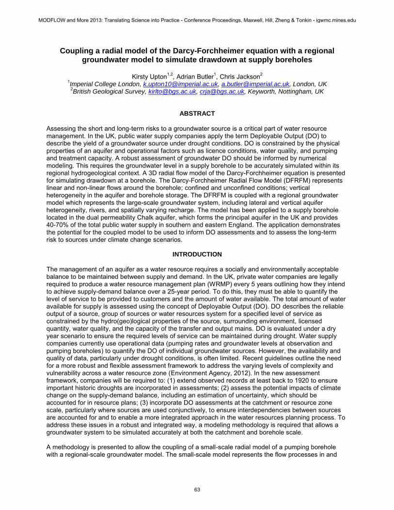
model to represent interference effects between neighboring pumping boreholes (Figure 1a). A DFRFM is coupled to the Cartesian grid such that a single radial boundary node links to a single Cartesian node and a simple approach is taken to handle flow across the irregularly shaped boundary blocks (Figure 1b). The hydrogeological properties and volume of the outer radial block remain constant. Flows between the outer and inner radial nodes (a1 and b in Figure 1b) are assumed to be radial and are calculated by replacing the irregularly shaped blocks with radial blocks of equivalent volume. Flows between the outer radial and Cartesian nodes (c and d in Figure 1b) are assumed to be orthogonal and are calculated by replacing the irregularly shaped blocks with rectangular blocks of equivalent volume. The angular flow between two boundary nodes is assumed to be radial and is calculated by replacing the irregular blocks with radial blocks (a2 and e in Figure 1b) of equivalent volume. This method maintains mass balance across the boundary between the two grids.
The coupled Darcy-Forchheimer radial-Cartesian model (DFRCM) is coded in MATLAB to facilitate rapid model development and use of the MATLAB solvers. The non-linear ODE15s solver, which utilizes adaptive time-stepping, is applied. Coupling with a Regional Groundwater Model
The outer Cartesian mesh allows the DFRCM to sit within an existing finite difference groundwater model which provides the regional hydrogeological context for the small-scale borehole model(s). The OpenMI Standard defines a method for exchanging data between models at run-time (Moore et al., 2010). Implementation of the standard allows models to be run simultaneously, exchanging data at specified points in time and space. The DFRCM has been made OpenMI compliant to allow coupling with the ZOOMQ3D groundwater modeling code (Jackson & Spink, 2004), which has been used to develop several regional groundwater models within the Thames Basin. ZOOMQ3D requires the location of the outer boundary and all pumping boreholes within the DFRCM. The pumping regime within the ZOOMQ3D model is controlled by the operational and management procedures implemented within the DFRCM. The two-way linkage transfers a pumping rate for each borehole within the DFRCM to ZOOMQ3D; boundary flows are passed back from ZOOMQ3D to provide a specified flux boundary condition to the DFRCM. This method provides the flexibility for the DFRCM to be quickly and easily coupled with any existing ZOOMQ3D regional groundwater model.
MODEL APPLICATION
The model has been applied to simulate a pumping test at a borehole in the Chalk aquifer of southern England. The site is located within the southern part of the London Basin where the Chalk is confined by the London Clay Formation. Geological logging of the borehole shows that the London Clay is
Figure 1. a) Coupled Darcy-Forchheimer radial-Cartesian model grid; b) Irregular blocks on the radial-Cartesian boundary.
MODFLOW and More 2013: Translating Science into Practice - Conference Proceedings, Maxwell, Hill, Zheng & Tonkin - igwmc.mines.edu
65
approximately 25 m thick at this site and is underlain by the Lambeth Group (6 m of sandy to pebbly clays), the Thanet Sands (20 m of fine, silty sands) and the Chalk. The Chalk has dual permeability consisting of a very fine-grained matrix with up to 40% porosity and a well developed fracture network through which the majority of groundwater flow occurs. The pumping borehole is drilled to a depth of 105 meters below ground level (mbgl) and is open hole from a depth of 58 mbgl (i.e. cased within the upper 7 m of the Chalk). Geophysics suggests there are several inflow horizons between 69 mbgl and 90 mbgl. A series of pumping and injection tests were carried out at the site during 2007 and 2008 to investigate the potential for an artificial recharge scheme.
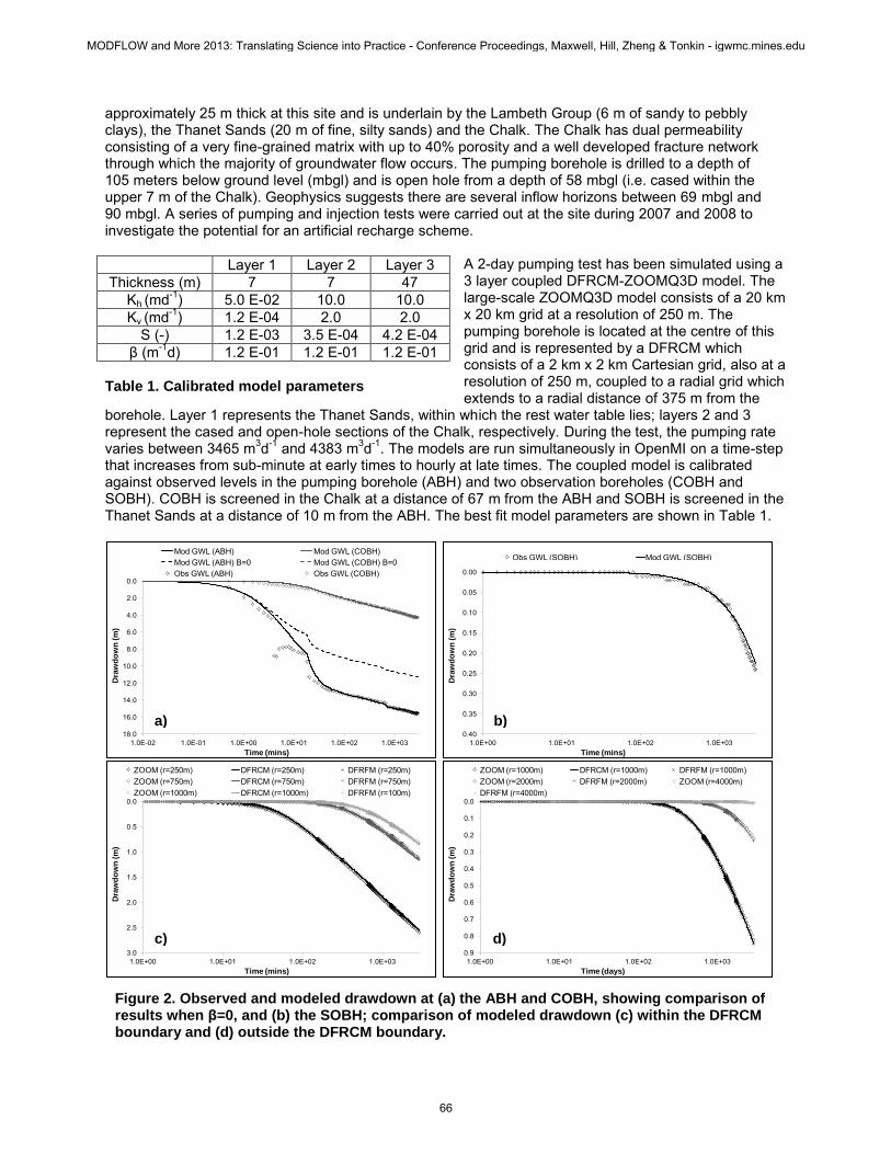
A 2-day pumping test has been simulated using a 3 layer coupled DFRCM-ZOOMQ3D model. The large-scale ZOOMQ3D model consists of a 20 km x 20 km grid at a resolution of 250 m. The pumping borehole is located at the centre of this grid and is represented by a DFRCM which consists of a 2 km x 2 km Cartesian grid, also at a resolution of 250 m, coupled to a radial grid which extends to a radial distance of 375 m from the
borehole. Layer 1 represents the Thanet Sands, within which the rest water table lies; layers 2 and 3 represent the cased and open-hole sections of the Chalk, respectively. During the test, the pumping rate varies between 3465 m3d-1 and 4383 m3d-1. The models are run simultaneously in OpenMI on a time-step that increases from sub-minute at early times to hourly at late times. The coupled model is calibrated against observed levels in the pumping borehole (ABH) and two observation boreholes (COBH and SOBH). COBH is screened in the Chalk at a distance of 67 m from the ABH and SOBH is screened in the Thanet Sands at a distance of 10 m from the ABH. The best fit model parameters are shown in Table 1.
0.0
2.0
4.0
6.0
8.0
10.0
12.0
14.0
16.0
18.01.0E-02 1.0E-01 1.0E+00 1.0E+01 1.0E+02 1.0E+03
Dra
wd
ow
n (m
)
Time (mins)
Mod GWL (ABH) Mod GWL (COBH)Mod GWL (ABH) B=0 Mod GWL (COBH) B=0Obs GWL (ABH) Obs GWL (COBH) 0.00
0.05
0.10
0.15
0.20
0.25
0.30
0.35
0.401.0E+00 1.0E+01 1.0E+02 1.0E+03
Dra
wd
ow
n (m
)
Time (mins)
Obs GWL (SOBH) Mod GWL (SOBH)
0.0
0.5
1.0
1.5
2.0
2.5
3.01.0E+00 1.0E+01 1.0E+02 1.0E+03
Dra
wd
ow
n (m
)
Time (mins)
ZOOM (r=250m) DFRCM (r=250m) DFRFM (r=250m)ZOOM (r=750m) DFRCM (r=750m) DFRFM (r=750m)ZOOM (r=1000m) DFRCM (r=1000m) DFRFM (r=100m)
0.0
0.1
0.2
0.3
0.4
0.5
0.6
0.7
0.8
0.91.0E+00 1.0E+01 1.0E+02 1.0E+03
Dra
wd
ow
n (m
)
Time (days)
ZOOM (r=1000m) DFRCM (r=1000m) DFRFM (r=1000m)ZOOM (r=2000m) DFRFM (r=2000m) ZOOM (r=4000m)DFRFM (r=4000m)
Layer 1 Layer 2 Layer 3 Thickness (m) 7 7 47
Kh (md-1) 5.0 E-02 10.0 10.0 Kv (md-1) 1.2 E-04 2.0 2.0
S (-) 1.2 E-03 3.5 E-04 4.2 E-04 β (m-1d) 1.2 E-01 1.2 E-01 1.2 E-01
Table 1. Calibrated model parameters
Figure 2. Observed and modeled drawdown at (a) the ABH and COBH, showing comparison of results when β=0, and (b) the SOBH; comparison of modeled drawdown (c) within the DFRCM boundary and (d) outside the DFRCM boundary.
a) b)
c) d)
MODFLOW and More 2013: Translating Science into Practice - Conference Proceedings, Maxwell, Hill, Zheng & Tonkin - igwmc.mines.edu
66
Figure 2a shows observed and modeled drawdown at the ABH and COBH. The results of the same model without the Forchheimer flow component (i.e. β=0) are also shown in Figure 2a. This has no impact on drawdown at the COBH but significantly underestimates drawdown at the ABH, highlighting the importance of being able to simulate non-linear losses within the borehole and aquifer during pumping. The model is also able to simulate drawdown in the overlying Thanet Sands (Figure 2b) which provide a small amount of leakage to the Chalk at late times. The cone of depression crosses the radial-Cartesian boundary within the DFRCM after 8 minutes of pumping and crosses the DFRCM-ZOOMQ3D boundary after 100 minutes of pumping. Figure 2c shows consistent drawdown in the ZOOMQ3D model and DFRCM at distances of 250 m, 750 m and 1000 m from the ABH. The coupled model is also consistent with drawdown in an uncoupled DFRFM with large areal extent, both within and outside the DFRCM boundary (Figures 2c and d, respectively), indicating that the coupling process is not having a significant impact on the model solution.
MODEL DEVELOPMENT AND FUTURE APPLICATION
The simple application above demonstrates the ability to link a radial flow model with the ZOOMQ3D groundwater modeling code. Future application will involve linking the DFRCM with a regional groundwater model of part of the River Thames catchment in southern England. The DFRCM will be calibrated against pumping test data for specific public water supply boreholes and used to investigate the operational behavior under historic simulations. This will allow observed records to be extended and current DO estimates to be reassessed in the context of historic droughts. It will also allow climate change scenarios to be applied to the coupled model to investigate potential changes in DO at individual sources and at the resource zone scale.
SUMMARY The methodology presented demonstrates the ability to couple a radial and Cartesian groundwater model, allowing a groundwater system to be simulated at the regional or catchment scale down to the scale of an individual pumping borehole. This provides a tool for investigating the reliable yield of individual groundwater sources under drought conditions and assessing how these yields might vary under climate change scenarios.
ACKNOWLEDGMENTS
The authors would like to thank Dr M. Jones and J. Richies at Thames Water Utilities Limited for their input in terms of both data and expertise. C Jackson publishes with the permission of the Executive Director of the British Geological Survey.
REFERENCES
Ding, Y. and Jeannin, L. (2004). New numerical schemes for near-well modeling using flexible grids. Spe Journal 9(1): 109-121.
Jackson, C. R. and Spink, A. E. F. (2004). User's manual for the groundwater flow model ZOOMQ3D. British Geological Survey Internal Report. IR/04/140.
Mathias, S. A. and Todman, L. C. (2010). Step-drawdown tests and the forchheimer equation. Water Resources Research 46.
Moore, R., Gijsbers, P., Fortune, D., Gregersen, J., Blind, M., Grooss, J. and Vanecek, S. (2010). OpenMI document series: Scope for the openmi (version 2.0). The OpenMI Document Series. R. Moore. Wallingford, UK, Centre for Ecology and Hydrology.
Mundal, S. S., Keilegavlen, E. and Aavatsmark, I. (2010). Simulation of anisotropic heterogeneous near-well flow using mpfa methods on flexible grids. Computational Geosciences 14(4): 509-525.
Pedrosa Jr, O. A. and Aziz, K. (1986). Use of a hybrid grid in reservoir simulation. SPE Reservoir Engineering.
MODFLOW and More 2013: Translating Science into Practice - Conference Proceedings, Maxwell, Hill, Zheng & Tonkin - igwmc.mines.edu
67