Embed Size (px)
Citation preview
Using Photo Interpretation to Produce Accurate Maps
Covertype Mapping Services
Since the 1930s, James W. Sewall Company has used aerial photography to
classify and map natural resources. Even with the advent of satellite imagery,
interpreted aerial imagery has remained the medium of choice for detailed
natural resource mapping. During the last 20 years, the process of creating
maps from photography has evolved into a highly digital workflow. Analog
photography has been replaced by digital imagery, and the end products are
almost exclusively digital files that reside in a geographic information system
(GIS). Sewall takes advantage of advanced technologies and analytic techniques
to produce maps that meet exacting specifications in interpretation and data
integrity.
PHOTO INTERPRETATION
Quality photo interpretation begins with experienced photo interpreters who
are familiar with the specific resource under classification. Sewall employs a
team of skilled interpreters who each have a mixture of field and interpretation
experience. These experiences enable them to develop the maps and interpret
the forest in a way that is meaningful to
forest managers on the ground and in the
office.
Sewall performs photo interpretation
digitally using softcopy workstations that
allow the interpreter to view digital imagery
in stereo (3D). This digital imagery, combined
with camera calibration parameters and a
digital elevation model (DEM), provide the
necessary measurements for the softcopy
software. Our photo interpreters pay careful
attention to the creation and placement of
stand boundaries, making updates in the 3D
environment as necessary. The forest cover
type calls are then input into a client specific data entry system that validates the
interpretation call and enters it directly into the cover type database, drastically
reducing the potential for data entry errors to occur. ArcGIS is coupled with the
softcopy workstation in the interpretation process, with project deliverables
most often provided in geodatabase or shapefile formats.
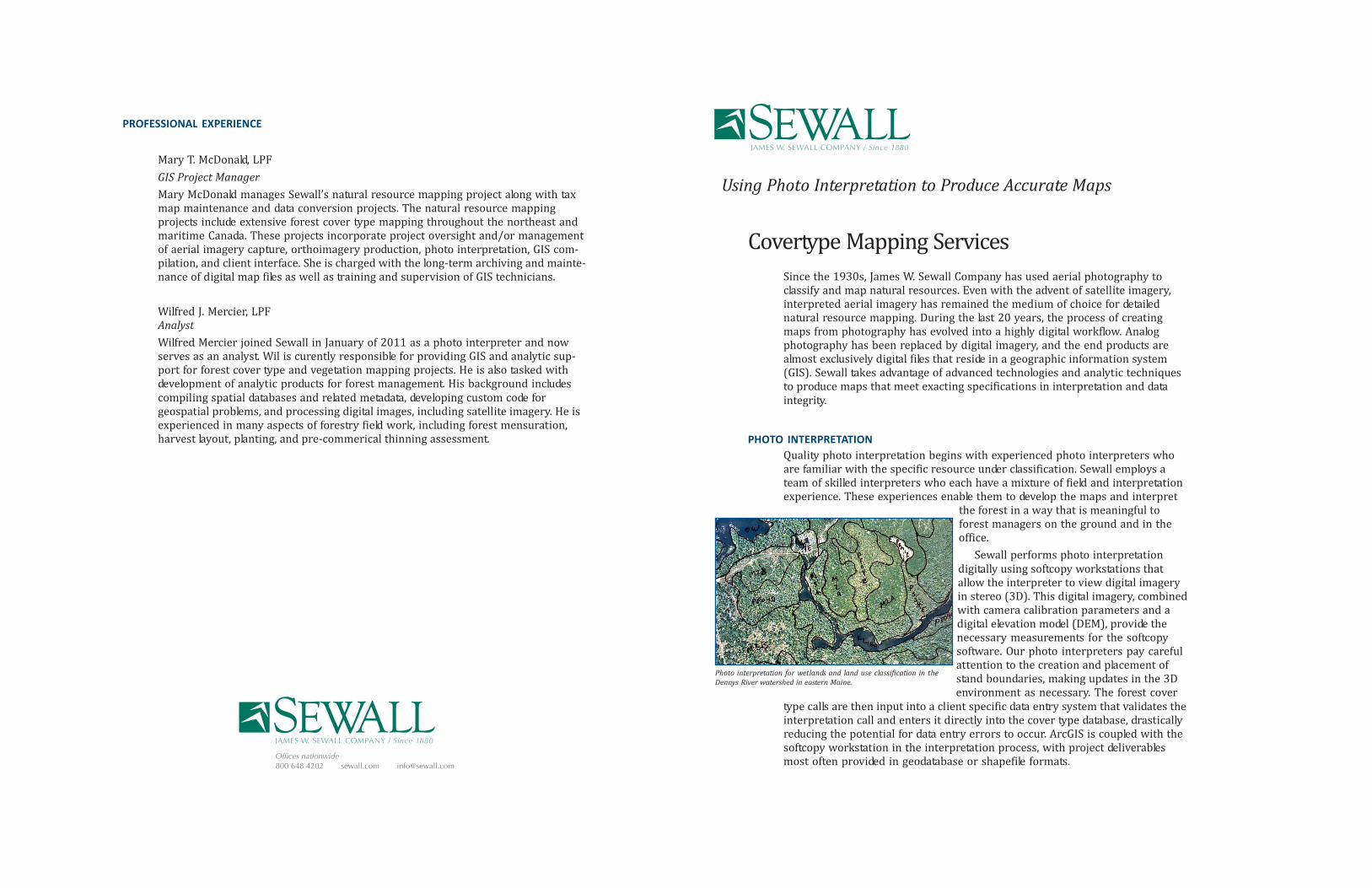
Photo interpretation for wetlands and land use classification in the
Dennys River watershed in eastern Maine.
PROFESSIONAL EXPERIENCE
Mary T. McDonald, LPF
GIS Project Manager
Mary McDonald manages Sewall’s natural resource mapping project along with tax
map maintenance and data conversion projects. The natural resource mapping
projects include extensive forest cover type mapping throughout the northeast and
maritime Canada. These projects incorporate project oversight and/or management
of aerial imagery capture, orthoimagery production, photo interpretation, GIS com-
pilation, and client interface. She is charged with the long-term archiving and mainte-
nance of digital map files as well as training and supervision of GIS technicians.
Wilfred J. Mercier, LPF
Analyst
Wilfred Mercier joined Sewall in January of 2011 as a photo interpreter and now
serves as an analyst. Wil is curently responsible for providing GIS and analytic sup-
port for forest cover type and vegetation mapping projects. He is also tasked with
development of analytic products for forest management. His background includes
compiling spatial databases and related metadata, developing custom code for
geospatial problems, and processing digital images, including satellite imagery. He is
experienced in many aspects of forestry field work, including forest mensuration,
harvest layout, planting, and pre-commerical thinning assessment.
Offices nationwide
800 648 4202 sewall.com [email protected]
FIELD VERIFICATION
Following a preliminary review of the aerial imagery, Sewall photo interpreters
generally perform “ground-truthing” in the field to address specific questions that
arise during photo interpretation. Although most field locations are pre-selected
with some consideration to accessibility, a number of sites are randomly chosen.
Depending on project scale, accuracy requirements, and budget, Sewall also
performs aerial reconnaissance.
In the fieldwork phase, our photo interpreters work closely with client
field personnel who are familiar with the subject area and the classification
system. The amount of checking and choice of method depends upon the com-
plexity of the classification system and accuracy requirements. On some projects,
Sewall performs interpretation in conjunction with an inventory, in which field
sampling observations are made independently of the photo interpretation pro-
cess. Using field sampling data and observations increases the accuracy of the
interpretation.
RIGOROUS QUALITY CONTROL
In addition to the quality control procedures followed during the photo interpre-
tation, cover type data is run through a rigorous set of quality control routines to
assure top quality data. The data are systematically checked for improbable
conditions, and, if present, these areas are reviewed by the interpreters to
correct any inconsistencies. In projects where multiple interpreters are needed,
additional interpretation cross checks are used to maintain consistency in the
product across the different interpreters.
ADDITIONAL DATA PRODUCTS
Generation of forest cover type maps often coincides with the acquistition of new
aerial imagery, which can be an excellent opportunity to collect additional infor-
mation about your land base that complements the forest cover typing product.
Examples of additional data that can be collected include road center lines, refine-
ment of water edges, delineation of gravel pits, and marking of timber harvesting
yard areas. Sewall can offer efficient collection of these or other data layers by
incorporating them into a forest cover type mapping project.
ADVANCED ANALYSIS
Sewall is constantly working to develop new analyses that rapidly and cost-effec-
tively provide enhanced information at the stand level. Our CanopyDataTM prod-
uct, which can provide one or multiple height estimates per stand, is an example
of how we can extract more information from your imagery and incorporate
those data into your new cover type map.
HISTORIC METHODOLOGIES
While Sewall’s current workflows utilize some of the most up-to-date methodolo-
gies available, our long history of providing photo interpretation supplies us with
the tools and skills needed to offer legacy interpretation and geospatial services
to clients who require it. This can include interpretation of film and hard copy
photography, as well as conversion of maps printed on paper, mylar, or acetates.
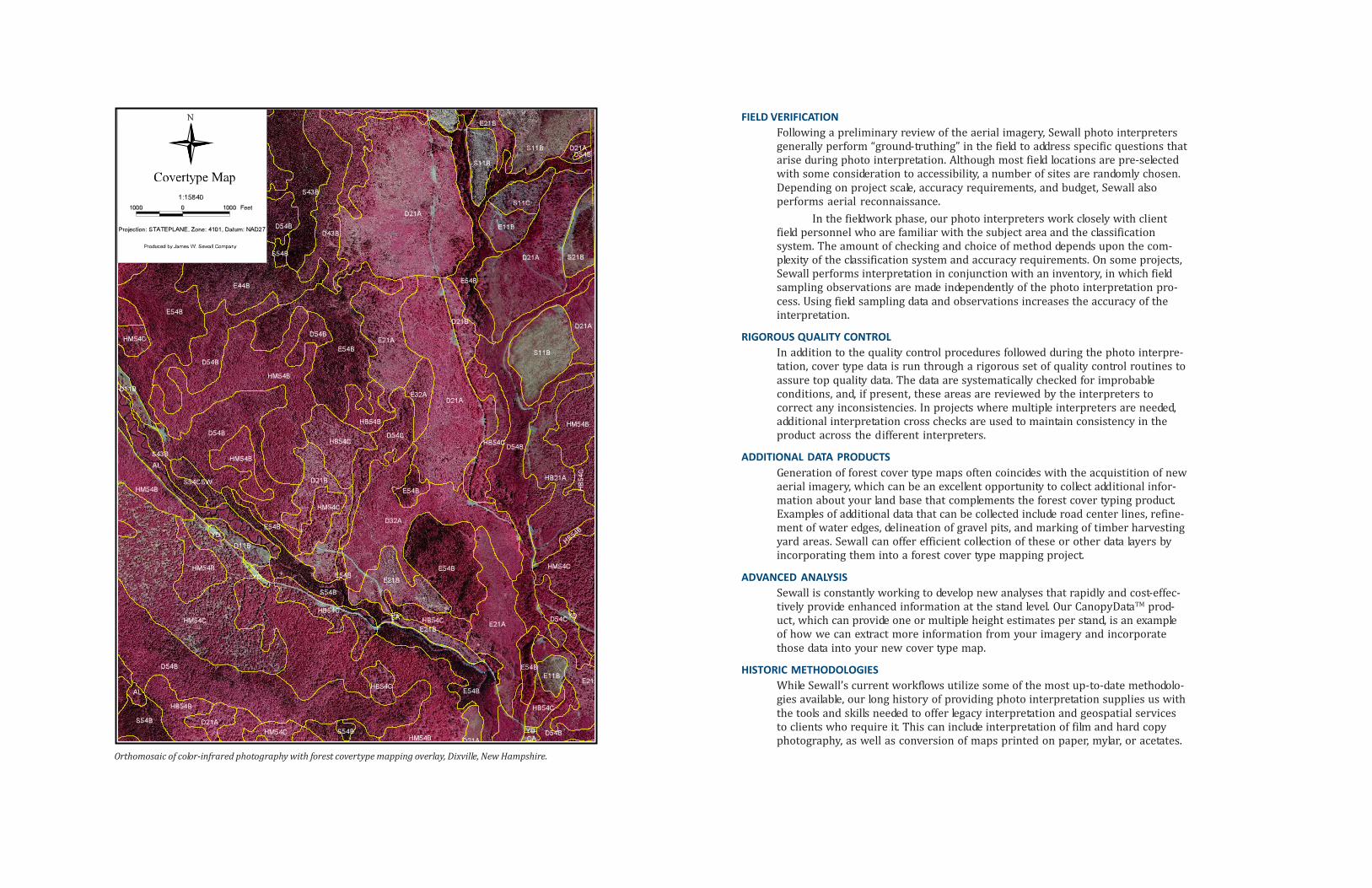
Orthomosaic of color-infrared photography with forest covertype mapping overlay, Dixville, New Hampshire.


![[1967] Sewall Wright - Surfaces of Selective Value](https://img.pdfslide.net/doc/110x75/577c805c1a28abe054a8574c/1967-sewall-wright-surfaces-of-selective-value.jpg)