Embed Size (px)
Citation preview

SHELL GULF OF MEXICO, Inc
WELLSITE GEOLOGICAL REPORT
OCS-Y-2321 Burger J 001
Posey 6912
Chukchi Sea, Alaska USA
Provided by:
Approved by: R.C. Scheidemann Compiled by: Jeff McBeth Ryan Massey
Distribution: 10/21/2015
PROPRIETARY

Shell OCS-Y-2321 Burger J 001 Posey Block 6912
CONFIDENTIAL 1
Contents 1 INTRODUCTION ................................................................................................................................... 2
1.1 Well Synopsis ................................................................................................................................. 2 1.2 Well Objective ................................................................................................................................. 2 1.3 Well Summary ................................................................................................................................ 2 1.4 Location Map .................................................................................................................................. 3 1.5 Difficulties and Delays (NPTs and Issues) for Individual Hole Intervals ......................................... 4
2 WELL DETAILS ..................................................................................................................................... 5 2.1 Well Resume .................................................................................................................................. 5
3 GEOLOGICAL DATA ............................................................................................................................. 7 3.1 Predrill Stratigraphic Column .......................................................................................................... 7 3.2 Tops (Prognosed vs Actual) ........................................................................................................... 8 3.3 Formation Summary (Descriptions) ................................................................................................ 8 3.4 Sidewall Core Summary Table ..................................................................................................... 10 3.5 Sampling Program / Sample Dispatch .......................................................................................... 11
4 WELL EVALUATION ........................................................................................................................... 12 4.1 LWD Log Suite Run ...................................................................................................................... 12 4.2 Wireline Log Suite Run ................................................................................................................. 13
5 DRILLING DATA .................................................................................................................................. 14 5.1 Daily Activity Summary ................................................................................................................. 14 5.2 Survey Data .................................................................................................................................. 18 5.3 BHA Diagrams .............................................................................................................................. 20 5.4 Preliminary Side Wall Core Report ............................................................................................... 27 5.5 Various Lithologies Observed in Main Objective Interval.............................................................. 30 5.6 Cuttings Fluorescence as observed in Main Objective Interval .................................................... 34 5.7 Intermediate Section Hole Stability Report ................................................................................... 38
PROPRIETARY

Shell OCS-Y-2321 Burger J 001 Posey Block 6912
CONFIDENTIAL 2
1 INTRODUCTION
1.1 Well Synopsis The OCS-Y-2321 Burger J 001, also known as Burger J well is a vertical exploration well for the 2015 Shell Exploration season drilled by Transocean on the Polar Pioneer semi-submersible drilling platform. Burger J spudded on July 30, 2015 and drilled to the TD of 6,800’ MD on 9/21/2015. The 8.5” Main Objective Interval was evaluated with an extensive LWD string to further evaluate the Kuparuk age equivalent C, A and D sands as seen in the SWEPI OCS-Y-1413 Burger no. 1 well drilled in 1989-1991. Wireline operations were also used for further evaluation (refer to Section 4.2 Wireline Log Suite Run for more information). Plug and abandoned operations began September 25th, 2015.
1.2 Well Objective The main objective of the Burger J well is to drill to 6,800’ MD and verify the presence of liquid hydrocarbons in the Kuparuk age equivalent C, A and D sands; evaluate the reservoir properties with both LWD and wireline logs, fluid sampling (MDT), and rotary sidewall cores.
1.3 Well Summary The 8.5” pilot hole (Run 100) spudded the Burger J well on July 30, 2015, with the BHA consisting of a mud motor, Gamma Ray, Resistivity, Neutron/Density, MRIL, XBAT, Directional tools. Run 100 drilled to a depth of 1,512’ MD and the 36” hole opener (Run 200) was then ran from 222’ MD to 384’ MD. Following was the Mud line cellar bit (Run 230), which drilled from 222’ MD to 257’ MD, opening a large enough hole in the sea floor mud line to place the blow out preventer equipment for protection from ice. Next the 42” hole opener (Run 300) was ran and drilled to 393’ MD, following that was surface casing (Run 340). The first attempt to run surface casing was unsuccessful and the 42” bit was re-ran (Run 341) for a cleanout. The 36” surface casing conductor was then ran successfully to 375’ MD (Run 342). Next a 26” hole opener bit (Run 400) was picked up and drilled 30’ of new hole and then tripped back to surface to pick up the Pressure While Drilling tool (Run 401) and then proceeded to drill out to 1,512’ MD. The 22” casing (Run 440) was then ran and cemented at 1,475’ MD. The 17-1/2” Intermediate Section (Run 500) consisted of a Pressure While Drilling and Directional tools with a mud motor. Drilling out with Run 500 began September 4th, 2015 at 1830 hours, drilling from 1,512’ to a TD of 2,963’ MD on September 6th, 2015. The 14” casing (Run 540) was then ran to bottom without issues and cemented in at 2,933’ MD. The 12-1/4” Intermediate Section (Run 600) consisted of Gamma Ray, Resistivity, Neutron/Density, XBAT, and Directional tools with a mud motor on the BHA and was picked up September 10th and drilled out September 11th, 2015. Total depth was reached at 5,423’ MD on September 13th at 1634 hrs. Upon tripping out, tight spots were encountered and circulation at the shoe resulted with a mass unloading of cavings consisting of large clay lumps (2-3”) and various shale fragments (1.5-2”). Run 600 was tripped back to bottom for a cleanout run. Shale inhibitors and mud sweeps were pumped, at bottoms up the cuttings were much smaller comparatively to the previous circulation at the shoe. Tripping out went smoothly and the BHA was racked back to expedite running the liner. The 9 5/8th liner was then run in hole September 16th. The liner weight began to slack off at ~5,318’ MD. The liner was continued to be run to ~5,412’ MD. Circulation was established at 265 gpm for 19 minutes until the annulus packed off and returns were lost (rate of 120 bph). The rig was able to establish partial returns. Total 60 bbls lost to
PROPRIETARY

Shell OCS-Y-2321 Burger J 001 Posey Block 6912
CONFIDENTIAL 3
this point. Pumped cement with minimal returns and material over shakers. The 8-1/2” Main Objective Section (Run 700) consisted of Gamma ray, Resistivity, Neutron/Density, XBAT, MRIL, and Directional tools on the BHA with a mud motor and was picked up September 19th and drilled out September 20th, 2015. Total depth was reached at 6,800’ MD on September 21st at 2309 hrs. The drill string was tripped out of the hole with minor tight spots. Minor drag was observed across the C/A Sands. Wireline operations began September 23rd with MDT-GR and followed with FMI-Sonic-GR. Finally, RSWC was executed targeting 50 sample points (see Section 3.4 for further details). Wireline rigged down September 25th and the cement stinger was picked up to move operation towards the plug and abandon stage.
1.4 Location Map
PROPRIETARY

Shell OCS-Y-2321 Burger J 001 Posey Block 6912
CONFIDENTIAL 4
1.5 Difficulties and Delays (NPTs and Issues) for Individual Hole Intervals Surface Interval 13-14 Aug Initial difficulty in running casing/conductor to bottom 24-30 Aug Weather conditions and ROV/SAM/HFL troubleshooting at surface Intermediate Interval
14-15 Sept Differential sticking / Pulling tight / Hole instability (see Section 5.7) 17 Sept Annulus packed off, 60 bbl loss while running liner Main Objective Interval No issues.
PROPRIETARY

Shell OCS-Y-2321 Burger J 001 Posey Block 6912
CONFIDENTIAL 5
2 WELL DETAILS
2.1 Well Resume
Burger J
General Well Data Table WELL NAME, API & LOCATION
Well Name OCS-Y-2321 Burger J 001 API/UWI 55-352-00004-00 Block/Lease Name Posey 6912 Area/Field Chukchi Sea State Alaska Country USA
COORDINATES Surface Location
Projection Datum NAD 83 Coordinate System UTM Zone 3 Latitude Longitude X (ft) Y (ft)
71° 10’ 24.0029” N 163º 28’ 18.522” W 555,036 7,897,424 Bottom hole Location
Projection Datum NAD 83 Coordinate System UTM Zone 3 Latitude Longitude X (ft) Y (ft)
71° 10’ 24.0029” N 163º 28’ 18.522” W 555,036 7,897,424 DATES
Spud Date 7/30/2015 17:05 TD Date 9/21/2015 23:09 P&A Date WSG released before P&A Rig Release Date WSG released before rig release
RIG & DATUM Water Depth 146 ft RT elevation (above MSL) 76 ft Rig Name Polar Pioneer Rig Company Transocean Rig Type Semi-submersible / Triple
TD and KOP ft MDRT ft TVDSS
Planned TD 6,800’ -6,724’ Pilot Hole Actual TD Driller 6,800’ -6,719’
PROPRIETARY

Shell OCS-Y-2321 Burger J 001 Posey Block 6912
CONFIDENTIAL 6
WELL OBJECTIVES Primary Objective
Formation Name Expected at Drilled at
Results MDRT TVDSS MDRT TVDSS
C SAND 5,926’ -5,850’ 5,873’ -5,795’ -55’ A SAND 6,006’ -5,930’ 5,968’ -5,889’ -41’ D SAND 6,511’ -6,435’ 6,451’ -6,719’ -64’
OFFSET WELLS
Well Name Operator Year Distance (surface
Location) Burger 1 SWEPI 1989/1990 ~8 mi
BOREHOLE & WELL PROFILE Borehole (pilot hole, by-pass or sidetrack) Pilot hole Well Profile (vertical, deviated, horizontal) Vertical Maximum deviation @ depth (MDRT) 3.99° @ 6,445’ and 6,745’ Deviation at TD 3.99°
SERVICE COMPANIES AND CONTRACTORS WSGs Waters Petroleum Advisors Mudlogging Sperry Drilling Wireline Logging Schlumberger LWD/MWD Sperry Drilling Coring n/a Mud MI-Swaco Cementing Halliburton
WELL CONFIGURATION
Hole Section
(")
Maximum Depth Mud Weight Casing/
Liner
Csg Diameter
(")
Shoe Depth FIT/ LOT
ft MD ft TVDSS ppg ft MD ft
TVDSS Depth
(ft MD) EMW (ppg)
42 375 -299 8.6 (Sea Water) Conductor 36 369 -293 n/a n/a
26 1,512 -1,436 8.6 Casing 22 1,475 -1,399 1,522 12.6 17.5 2,963 -2,887 10.4 Casing 14 2,933 -2,857 2,933 14.0
12.25 5,423 -5,347 11.4 Liner 9 5/8 5,408 -5,347 5433 15.28 8.5 6,800 -6,719 12 - - - - - -
Gains/Losses MDRT (ft) Loss/Gains Barrels lost/gained Control Time Comments
5,423 Loss 2 20 min Likely small sand stringer up hole broke down and quickly sealed
5,423 Loss 60 2 hr Hole packed off while running liner
PROPRIETARY

Shell OCS-Y-2321 Burger J 001 Posey Block 6912
CONFIDENTIAL 7
3 GEOLOGICAL DATA
3.1 Predrill Stratigraphic Column
PROPRIETARY

Shell OCS-Y-2321 Burger J 001 Posey Block 6912
CONFIDENTIAL 8
3.2 Tops (Prognosed vs Actual) Provisional Formation Tops Formation Prognosed Tops (ft) Actual Tops (Provisional) (ft) Diff Picked On
MDRT TVDRT TVDSS MDRT TVDRT TVDSS (+/- ft) Top Torok 2,755 2,755 -2,679 2,760 2,760 -2,684 5 Cuttings Torok Gas Sand 3,251 3,251 -3,175 3,275 3,275 -3,199 24 LWD Top HRZ 5,346 5,346 -5,270 5,024 5,023 -4,947 -323 TBD Top Pebble Shale 5,652 5,652 -5,576 5,539' 5,536' -5,460' -116' LWD Top C Sand 5,926 5,926 -5,850 5,873' 5,871' -5,795' -55' LWD Top A Sand 6,006 6,006 -5,930 5,968' 5,965' -5,889' -41' LWD Top D Sand 6,511 6,511 -6,724 6,451' 6,447' -6,371' -64' LWD Tops based off LWD field picks.
3.3 Formation Summary (Descriptions)
NANUSHUK (220’ – 2,760’ MD) Sampling of the Nanushuk Formation began at 1,512’ MD, when the rig first took returns. CLAYSTONE: Medium to light gray, soft to firm, rarely hard, blocky, earthy to waxy, generally hydrophilic, commonly silty. SILTSTONE/ SILTY SANDSTONE: Light gray, friable to firm. Silty sandstone is silty to very fine grained, well sorted, common clear quartz grains and dark gray to black lithics, possible carbonaceous material, calcareous or argillaceous cement in most samples.
TOROK (2,760’ – 5,024’ MD) CLAYSTONE: Gray to medium gray to dark gray, soft to friable, firm in part, blocky, earthy, slightly silty, occasionally hydrated, PDC curl cuttings habit common. SILTSTONE: Gray to light gray, silt to lower very fine, calcareous. SANDSTONE: Light gray, very fine, sub-round, well sorted, moderate calcareous cement, fair visible porosity, slightly tuffaceous. SHALE: Medium dark gray, firm, poorly fissile
HRZ (5,024’ – 5,539’ MD) SHALE: Medium dark gray, hard to brittle, earthy, slightly silty CLAYSTONE: Medium light gray to medium gray, soft, fragile SILSTONE: Light gray, occasionally grades to very fine sandstone, rare pyrite
PROPRIETARY

Shell OCS-Y-2321 Burger J 001 Posey Block 6912
CONFIDENTIAL 9
PEBBLE SHALE (5,539’ – 5,873’ MD) SHALE: medium dark gray, firm to moderately hard, flaky to splintery, laminated, fissile CLAYSTONE: Medium gray to medium dark gray with common brownish hues, firm to hard, moderate to well indurated, blocky to elongated, occasionally silty, trace pyrite SILTSTONE: Medium gray with brownish hue, common pyrite, common carbonate, trace tuff, grading to very fine gray sand SANDSTONE: Light gray with translucent to transparent, very fine with trace floating medium grains, sub round to sub angular, poor sorting, calcareous cement
C SAND (5,873’ – 5,968’ MD)
For further descriptions and pictures, see Section 5.5 below.
SANDSTONE: Gray to medium gray with abundant translucent to transparent and common white grains, very fine to fine with scattered medium, well to moderate sorted, sub round, abundant carbonaceous, trace glauconite, trace siderite cement CLAYSTONE: Medium gray to dark gray, soft to firm
A SAND (5,968’ – 5,996’ MD) SANDSTONE: Light gray to medium gray with abundant transparent to translucent grains, well sorted, subrounded to subangular, abundant carbonaceous material, common lithics SILTSTONE: medium gray with brownish hues, soft to friable, argillaceous matrix, clayey, mushy, amorphous
D SAND (6,451’ – 6,568’ MD) For further descriptions and pictures, see Section 5.6 below SANDSTONE: Light gray to medium gray with abundant transparent to translucent grains, fine lower grains to silty, moderately sorted, subrounded to subangular, calcareous cement in part, scattered tuffaceous clay matrix, abundant carbonaceous material, common lithics, rare pyrite, glauconite, N/S visible oil, Fluorescence: moderately abundant, spotty, orange, Cut: slow, dull, yellow to dull yellow fluorescence, immediate bright yellow crush cut fluorescence, dull yellow residual fluorescence SILTSTONE: Light gray to medium gray, easily friable to friable, dull yellow fluorescence even over 40% of sample, faint slow dull yellow crush fluorescence, dull yellow fluorescence CLAYSTONE: Light gray to medium gray, soft to moderately hard, moderate induration, silty, slightly calcareous
PROPRIETARY
Shell OCS-Y-2321 Burger J 001 Posey Block 6912
CONFIDENTIAL 10
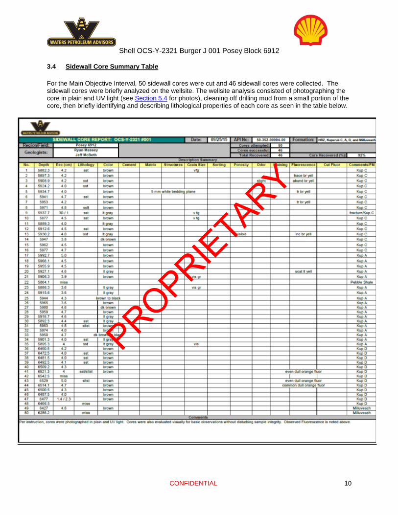
3.4 Sidewall Core Summary Table For the Main Objective Interval, 50 sidewall cores were cut and 46 sidewall cores were collected. The sidewall cores were briefly analyzed on the wellsite. The wellsite analysis consisted of photographing the core in plain and UV light (see Section 5.4 for photos), cleaning off drilling mud from a small portion of the core, then briefly identifying and describing lithological properties of each core as seen in the table below.
PROPRIETARY

Shell OCS-Y-2321 Burger J 001 Posey Block 6912
CONFIDENTIAL 11
3.5 Sampling Program / Sample Dispatch Halliburton-Sperry services provided mud logging, sample catching and steam sill analysis. Sampling was as followed:
Cuttings Samples
• Every 30' • 10’ in Zones of Interest (ZOI)
• 4 Bags of Wet Ditch Cuttings. • Minimum 1000 grams per sample. • Consolidated in rice sacks with 10 per sack. • 4 sets of fully washed and air-dried cuttings
• 4 Sets to be packed and stored for shipping
Steam Still • Every 30' • 10’ in ZOI
Isotubes
• Every 90' through 17.25” • 12.25”: Every 90’ / 10’ through ZOI • 8.25”: Every 10’
Mud Samples • Every 1000' • 2 Samples across the Torok Sands and Kuparuk C, A, and D Sands
Mud Additives • Collect an additive sample for each set of wet cuttings • Collect a 15cc sample of ALL solid additives
Geochron Samples • As per Geologist
PROPRIETARY

Shell OCS-Y-2321 Burger J 001 Posey Block 6912
CONFIDENTIAL 12
4 WELL EVALUATION
4.1 LWD Log Suite Run Surface 8.5” (Opened to 26” later) BHA#01 / Run#100:
Sensor Distance to Bit Vibration 3.86
Gamma Ray 6.67 Pressure 9.49
Directional 17.02 QBAT/Sonic 32.85 Resistivity 59.89
Density 79.17 Porosity 92.13
MRIL NMR 109.6 Intermediate 1 17. 5” BHA#05 / Run 500:
Sensor Distance to Bit D & I (at bit) 79.96
Pressure 89.88 Intermediate 2 12.25” BHA#06 / Run 600:
Sensor Distance to Bit Gamma Ray 37.22 Resistivity 45.42 Directional 56.82 Pressure 70.67 Density 87.77 Porosity 106.44 Sonic 130.62
PROPRIETARY

Shell OCS-Y-2321 Burger J 001 Posey Block 6912
CONFIDENTIAL 13
Main Objective Interval 8.5” BHA#07 / Run 700:
Sensor Distance to Bit Gamma Ray 38.4
Pressure 41.27 Directional 48.8
Sonic 64.79 Azimuthal Deep Resistivity 95.88
Azimuthal Litho-Density 113.16 Neutron 126.09
Magnetic Resonance Image Logging
143.06
4.2 Wireline Log Suite Run E-line Services provided by Schlumberger Shell Petrophysicists were on location monitoring wireline operations.
Run Date Tool Suite Failure/Incidents
1 9/23/2015 MDT-GR None
2 9/24/2015 FMI-SS-GR-HRLA
None
3 9/25/2015 RSWC
Recovered 46 out
50 RSWC
PROPRIETARY

Shell OCS-Y-2321 Burger J 001 Posey Block 6912
CONFIDENTIAL 14
5 DRILLING DATA
5.1 Daily Activity Summary 25-July Rig beginning to deploy anchors.
26-July Continue anchor deployment, begin picking up pipe and racking back, begin picking up BHA.
27-July Finish picking up BHA, bring on brine and chemicals to make mud.
28-July Continue rig maintenance and repairing barite system, pick up dumb iron BHA to tag bottom and check water depth.
29-July Water depth checked to 146' MD, complete rig repairs on Barite tanks, build kill mud and sweeps. Begin Picking up 8.5' pilot hole BHA.
30-July Troubleshoot MWD tools, begin picking up BHA, complete BHA pick up and TIH to sea floor, shallow pulse test and begin drilling the 8.5' section as 17:02 pm 07/30/2015. No sweeps pumped.
31-July Continue to drill from 438' MD to 1005' MD. Pump 20 bbl sweeps every stand. Lithology has consisted of mainly silt w/ beds of coal, sand, and clay based off MWD data.
1-Aug Continue to drill from 1005' MD to 1512' MD, TD Pilot Hole section at 1512' MD, pump 20 bbl sweeps every stand. Pull out oh hole and lay down BHA #1.
2-Aug Pick up BHA #2 & drill ahead from 222' MD to 384' MD w/ 36" hole opener. Pull out of hole & begin to lay down BHA #2.
3-Aug Pick up MLC bit. Wait on weather.
4-Aug Continue to wait on weather. Prep to run in hole w/ MLC. Perform maintenance on standpipe.
5-Aug Continue repair kelly hose. Run in hole w/ MLC & drill ahead from 222' MD to 230' MD.
6-Aug Drill ahead from 230' MD to 241' MD w/ MLCB. Pull off bottom to inspect MLCB.
7-Aug Pull out of hole w/ MLCB. Inspect MLCB & clean off.
8-Aug Continue to clean off MLCB. Run in hole w/ MLC & tag bottom. Rig maintenance on pump.
9-Aug Finish rig maintenance on pump. Drill ahead w/ MLCB from 241' MD to 257' MD. Circulate & clean out hole.
10- Aug TOOH w/ MLCB. Clean off MLCB & prepare rig floor for 42" hole opener. Perform rig maintenance on pumps.
11- Aug Rig down MLC equip. Pick up BHA #3. Run in hole w/ BHA #3 & drill ahead from 257' MD to 287' MD w/ 42" hole
PROPRIETARY

Shell OCS-Y-2321 Burger J 001 Posey Block 6912
CONFIDENTIAL 15
opener.TO 2500 PSI. DRILL
12- Aug Drill ahead from 287' MD to 393' MD w/ 42" hole opener. Displace well with WBSF. Pull out of hole & lay down BHA #3. Begin to rig up 36" conductor casing equip.
13- Aug Rig up equip to run in hole w/ 36" conductor. Run in hole w/ conductor.
14- Aug Pull out of hole w/ conductor & pick up BHA. Run in hole w/ BHA & wash hole clean.
15- Aug Pull out of hole w/ BHA & lay down. Pick up 36" casing & run in hole. Rig up to cement casing. Pressure test cement lines.
16- Aug Pump cement. Wait on cement.
17- Aug Continue to wait on cement. Decision made to re-cement 36" casing. Pump cement & wait on cement. Rig down cement equip and pick up clean out BHA.
18- Aug Run in hole w/ 26" clean out BHA. Clean out hole and drill new hole to 425' MD. Pull out of hole & lay down BHA. Pick up drilling BHA & run in hole.
19- Aug Drill ahead from 425' MD to 1245' MD w/ 26" hole opener. Pump sweeps every 45'.
20- Aug Drill ahead from 1245' MD to TD of 1512' MD w/ 26" hole opener. Pump sweeps every 45'. Short trip 3 stands & run in hole to 1512' MD. CBU & displace to 10.5 ppg WBSF. Trip out of hole & lay down BHA. Clean rig floor & rig up 22" casing equip.
21- Aug Continue to rig up 22" casing equip. run in hole w/ 22" casing.
22- Aug Continue to run in hole w/ 22" casing & set at 1475' MD. Rig up cement equip & cement 22" casing. Prepare to set BOP.
23- Aug Pull out of hole with 5" inner string and rig down all temporary piping from cement job. Perform rig maintenance and skid rig 200' off well center for BOP deployment. Assist subsea with changing the choke stab on the KT ring. Rig up marine riser equipment and function test. Pick up and run marine riser to 105' and assist with changing the choke stab on the KT ring.
24- Aug Assist subsea with changing choke stab seals on KT ring, remove boost stab and install blank flange. Install choke and kill drape hoses on KT ring. Scope out pod line tensioners, tie back the COP tensioner guideline and transport BOP to well center. Attached the cobra head to tugger and install beacons on BOP stack. Lower riser and land on BOP. Install guide line cables in BOP guide line guides. Wait on Nordica to deploy HFL due to weather.
25- Aug Continue to wait on weather to deploy HFL. Nordica deploy HFL skid and attempt to install on subsea mud matte with assistance from ROV. Wait on weather to deploy BOP.
26- Aug Continue to wait on weather.
27- Aug Continue to wait on weather.
28- Aug Continue to wait on weather. Begin to skid rig.
PROPRIETARY
Shell OCS-Y-2321 Burger J 001 Posey Block 6912
CONFIDENTIAL 16
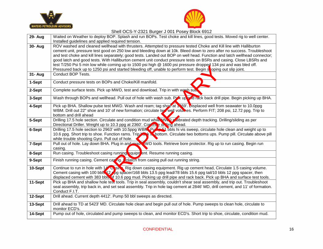
29- Aug Waited on Weather to deploy BOP. Splash and run BOPs. Test choke and kill lines, good tests. Moved rig to well center. Installed guidelines and applied required tension.
30- Aug ROV washed and cleaned wellhead with thrusters. Attempted to pressure tested Choke and Kill line with Halliburton cement unit, pressure test good on 250 low and bleeding down at 10k. Bleed down to zero after no success. Troubleshoot and test choke and kill lines separately; good tests. Landed out BOP on well head. Function and latch wellhead connector; good latch and good tests. With Halliburton cement unit conduct pressure tests on BSRs and casing. Close LBSRs and test T/250 Psi 5 min low while coming up to 1500 psi high @ 1600 psi pressure dropped 134 psi and was bled off. Pressured back up to 1250 psi and started bleeding off, unable to perform test. Begin scoping out slip joint.
31- Aug Conduct BOP Tests.
1-Sept Conduct pressure tests on BOPs and Choke/Kill manifold.
2-Sept Complete surface tests. Pick up MWD, test and download. Trip in with wash sub.
3-Sept Wash through BOPs and wellhead. Pull out of hole with wash sub. Pick up and rack back drill pipe. Begin picking up BHA.
4-Sept Pick up BHA. Shallow pulse test MWD. Wash and ream; tag shoe at 1469'. Displaced well from seawater to 10.0ppg WBM. Drill out 22" shoe and 10' of new formation; circulate two well volumes. Perform FIT; 208 psi, 12.72 ppg. Trip to bottom and drill ahead
5-Sept Drilling 17.5 hole section. Circulate and condition mud while MWD calibrated depth tracking. Drilling/sliding as per Directional Driller. Weight up to 10.3 ppg at 2360'. Continue drilling ahead.
6-Sept Drilling 17.5 hole section to 2963' with 10.5ppg WBM. Pump 51 bbls hi vis sweep, circulate hole clean and weight up to 10.6 ppg. Short trip to shoe. Function rams. Trip back to bottom. Circulate two bottoms ups. Pump pill. Circulate above pill while trouble shooting Gyro. Pull out of hole.
7-Sept Pull out of hole. Lay down BHA. Plug in and read MWD tools. Retrieve bore protector. Rig up to run casing. Begin run casing.
8-Sept Run casing. Troubleshoot casing running equipment. Resume running casing.
9-Sept Finish running casing. Cement casing. Unlatch from casing pull out running string.
10-Sept Continue to run in hole with 14" Casing. Rig down casing equipment. Rig up cement head, Circulate 1.5 casing volume. Cement casing with 100 bbls 12 ppg spacer/168 bbls 13.5 ppg lead/78 bbls 15.6 ppg tail/10 bbls 12 ppg spacer, then displaced cement with 383 bbls of 10.6 ppg mud. Picking up drill pipe and rack back. Pick up BHA and surface test tools.
11-Sept Pick up BHA and shallow hole test tools. Trip in seal assembly, couldn't shear seal assembly, and trip out. Troubleshoot seal assembly, trip back in, and set seal assembly. Trip in hole tag cement at 2846' MD, drill cement, and 11' of formation. Conduct F.I.T.
12-Sept Drill ahead. Current depth 4412'. Pump 50 bbl sweeps as directed.
13-Sept Drill ahead to TD at 5423' MD. Circulate hole clean and begin pull out of hole. Pump sweeps to clean hole, circulate to monitor ECD's.
14-Sept Pump out of hole, circulated and pump sweeps to clean, and monitor ECD's. Short trip to shoe, circulate, condition mud.
PROPRIETARY

Shell OCS-Y-2321 Burger J 001 Posey Block 6912
CONFIDENTIAL 17
Trip in to 4969' MD. Wash and ream to bottom. Continue circulating, pumping sweeps, and monitoring returns at report time.
15-Sept Complete rig repairs. Short trip five stands then back to bottom. Circulate bottoms up, max gas 63 units. Pull out of hole. Rack back BHA.
16-Sept Rack back BHA. Rig up casing equipment and run in hole with casing to 2,716’ MD. Pick up liner hanger and run in hole on drill pipe from 2,716’ MD to 3,070’ MD.
17-Sept Trip in with liner from 3,070’ MD to 5,379’ MD, liner string taking weight. Circulate and work liner to ~5,408’ MD. Annulus packed off and lost 60 bbls, regain partial returns. Pressure test cement lines, pump cement, release dart, displace and land dart. Reverse circulate out and rig down cementers.
18-Sept Rig down cementers. Trip out of hole 10 stands, hang off and pick up test joint. Test BOPE.
19-Sept Finish testing BOPE and lay down test joint. Pull out of hole, test casing and shear rams. Pick up BHA and shallow pulse test tools (good). Single in hole to 2,110’ MD
20-Sept Single in hole to 2,418’ MD, trip in hole with stands to 5,099’ MD. Wash and ream to 5,286’ MD. Circulate and condition, obtain slow pump rates. Drill cement and casing shoe, drill new hole to 5,433’ MD, circulate hole clean. Perform FIT (Good), drill ahead from 5,433’ MD to 5,852’ MD.
21-Sept Drill ahead from 5,852’ MD to TD of 6,800’ MD. Circulate bottoms up.
22-Sept Circulate and reciprocate drill string. Pull out of the hole and rack back BHA.
23-Sept Rig up and begin wireline operations. Finish run #1 (MDT-GR), rig tools down and rig up run #2 (FMI-SS-GR-HRLA).
24-Sept Perform run #2 (FMI-SS-GR-HRLA) of wireline operations. Rig tools down and rig up for run #3 (RSWC). Begin run #3 (RSWC).
25-Sept Complete run #3 (RSWC). Lay down and process cores. Package and prep RSWC for transport. Lay down BHA and download tools. Pick up cement stinger.
26-Sept Wellsite Geologists released from rig.
PROPRIETARY

CONFIDENTIAL 18
5.2 Survey Data
Measured Depth Inclination Azimuth
True Vertical Depth
Vertical Section
Latitude North/South
Departure East/West
Dog-Leg Severity
0.00 0.00 0.00 0.00 0.00 0.00 0.00 0.00 220.00 0.00 0.00 220.00 0.00 0.00 0.00 0.00 320.88 0.51 129.60 320.88 -0.29 -0.29 0.35 0.50 406.77 0.31 89.93 406.76 -0.53 -0.53 0.88 0.39 495.25 0.99 122.22 495.24 -0.93 -0.93 1.76 0.84 590.43 0.31 82.72 590.41 -1.34 -1.34 2.71 0.81 684.05 0.64 327.24 684.03 -0.87 -0.87 2.68 0.88 866.10 0.28 101.20 866.08 -0.09 -0.09 2.55 0.47 957.99 0.00 269.46 957.97 -0.13 -0.13 2.77 0.30 1051.65 0.14 176.72 1051.63 -0.24 -0.24 2.78 0.15 1144.54 0.26 120.65 1144.52 -0.46 -0.46 2.97 0.23 1235.66 0.41 134.11 1235.63 -0.80 -0.80 3.38 0.19 1328.60 0.51 59.75 1328.58 -0.83 -0.83 3.98 0.61 1378.50 0.25 111.62 1378.48 -0.76 -0.76 4.27 0.81 1540.18 0.12 50.83 1540.15 -0.78 -0.78 4.74 0.14 1723.74 0.39 34.99 1723.71 -0.14 -0.14 5.26 0.15 1818.58 0.58 50.01 1818.55 0.43 0.43 5.81 0.24 2003.18 1.06 39.81 2003.12 2.35 2.35 7.62 0.27 2095.93 0.87 35.51 2095.87 3.57 3.57 8.57 0.22 2186.15 0.69 72.12 2186.07 4.30 4.30 9.49 0.57 2373.34 0.75 76.36 2373.25 4.93 4.93 11.76 0.04 2463.93 0.78 75.65 2463.83 5.23 5.23 12.93 0.03 2555.30 0.79 70.25 2555.19 5.59 5.59 14.13 0.08 2646.22 0.79 76.51 2646.11 5.95 5.95 15.33 0.10 2743.03 0.70 74.08 2742.91 6.27 6.27 16.55 0.10 2837.42 0.74 67.59 2837.29 6.66 6.66 17.68 0.10 2875.38 0.64 69.95 2875.25 6.83 6.83 18.10 0.27 2978.31 0.74 64.69 2978.17 7.31 7.31 19.25 0.11 3074.55 0.58 52.33 3074.40 7.88 7.88 20.20 0.22 3169.04 0.67 47.05 3168.89 8.55 8.55 20.99 0.11 3258.93 0.77 27.36 3258.77 9.44 9.44 21.65 0.30 3351.80 0.94 33.05 3351.63 10.64 10.64 22.35 0.21 3445.40 0.89 33.34 3445.22 11.90 11.90 23.18 0.06 3537.90 0.88 39.68 3537.71 13.05 13.05 24.03 0.11 3630.29 0.86 29.57 3630.09 14.20 14.20 24.82 0.17 3724.13 1.05 46.97 3723.91 15.40 15.40 25.80 0.37 3815.47 1.16 37.46 3815.23 16.71 16.71 26.98 0.24 3909.95 1.11 27.77 3909.70 18.28 18.28 27.99 0.21 4001.96 1.54 18.87 4001.69 20.24 20.24 28.80 0.52 4095.18 1.55 21.22 4094.87 22.60 22.60 29.67 0.07 4189.17 1.52 19.27 4188.83 24.97 24.97 30.54 0.06
PROPRIETARY

CONFIDENTIAL 19
4280.67 1.73 13.84 4280.29 27.46 27.46 31.27 0.28 4373.26 2.11 22.24 4372.83 30.39 30.39 32.25 0.51 4465.71 1.69 19.56 4465.23 33.26 33.26 33.35 0.46 4559.04 2.02 19.56 4558.51 36.11 36.11 34.37 0.35 4651.17 2.19 23.91 4650.58 39.24 39.24 35.62 0.25 4743.27 2.64 25.07 4742.59 42.77 42.77 37.23 0.49 4836.87 3.09 32.03 4836.08 46.87 46.87 39.49 0.61 4929.20 3.15 34.87 4928.26 51.06 51.06 42.26 0.18 5021.52 3.28 37.85 5020.45 55.22 55.22 45.33 0.23 5113.59 3.34 39.69 5112.36 59.37 59.37 48.66 0.13 5206.14 3.59 47.76 5204.74 63.39 63.39 52.52 0.59 5299.05 3.70 48.27 5297.46 67.34 67.34 56.92 0.12 5364.19 3.45 52.11 5362.48 69.95 69.95 60.04 0.54 5429.81 3.65 46.91 5427.97 72.59 72.59 63.12 0.58 5518.31 3.73 45.18 5516.29 76.55 76.55 67.22 0.15 5612.70 3.58 42.26 5610.48 80.90 80.90 71.39 0.25 5704.09 3.56 42.97 5701.70 85.09 85.09 75.24 0.06 5795.19 3.47 41.51 5792.62 89.22 89.22 79.00 0.13 5889.32 3.48 42.48 5886.58 93.46 93.46 82.82 0.06 5980.70 3.42 42.67 5977.80 97.52 97.52 86.54 0.07 6075.07 3.43 41.69 6072.00 101.69 101.69 90.33 0.06 6167.81 3.55 39.12 6164.57 105.99 105.99 93.98 0.21 6259.59 3.53 39.52 6256.17 110.37 110.37 97.57 0.03 6346.61 3.75 37.26 6343.02 114.70 114.70 100.99 0.30 6445.34 3.99 34.54 6441.52 120.10 120.10 104.89 0.31 6536.48 3.96 35.37 6532.44 125.27 125.27 108.51 0.07 6628.63 3.92 37.01 6624.37 130.38 130.38 112.25 0.13 6721.62 3.89 35.41 6717.15 135.49 135.49 115.99 0.12 6745.05 3.99 35.86 6740.52 136.80 136.80 116.93 0.46
PROPRIETARY

CONFIDENTIAL 20
5.3 BHA Diagrams BHA 1
PROPRIETARY

CONFIDENTIAL 21
BHA 2
BHA 3
Not Available
PROPRIETARY

CONFIDENTIAL 22
BHA 4A
PROPRIETARY

CONFIDENTIAL 23
RUN 4B
PROPRIETARY

CONFIDENTIAL 24
BHA 5
PROPRIETARY

CONFIDENTIAL 25
BHA 6
PROPRIETARY

CONFIDENTIAL 26
BHA 7
PROPRIETARY

CONFIDENTIAL 27
5.4 Preliminary Side Wall Core Report
PROPRIETARY

CONFIDENTIAL 28
PROPRIETARY

CONFIDENTIAL 29
PROPRIETARY

CONFIDENTIAL 30
5.5 Various Lithologies Observed in Main Objective Interval
PROPRIETARY

CONFIDENTIAL 31
PROPRIETARY

CONFIDENTIAL 32
PROPRIETARY

CONFIDENTIAL 33
PROPRIETARY

CONFIDENTIAL 34
5.6 Cuttings Fluorescence as observed in Main Objective Interval
PROPRIETARY

CONFIDENTIAL 35
PROPRIETARY

CONFIDENTIAL 36
PROPRIETARY

CONFIDENTIAL 37
PROPRIETARY
CONFIDENTIAL 38
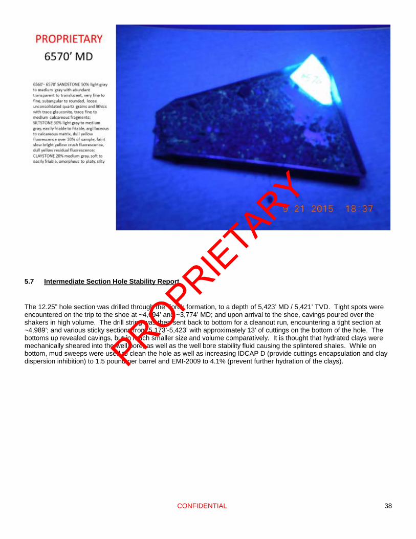
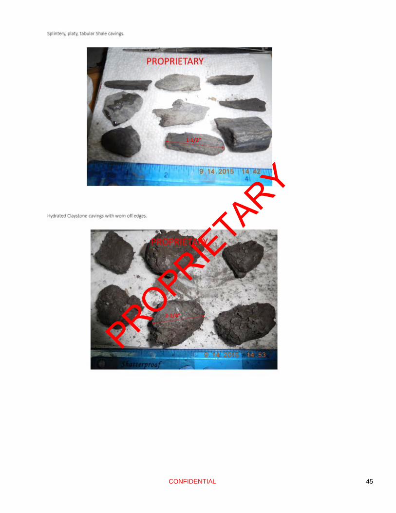
5.7 Intermediate Section Hole Stability Report The 12.25” hole section was drilled through the Torok formation, to a depth of 5,423’ MD / 5,421’ TVD. Tight spots were encountered on the trip to the shoe at ~4,694’ and ~3,774’ MD; and upon arrival to the shoe, cavings poured over the shakers in high volume. The drill string was then sent back to bottom for a cleanout run, encountering a tight section at ~4,989’; and various sticky sections from 5,173’-5,423’ with approximately 13’ of cuttings on the bottom of the hole. The bottoms up revealed cavings, but in much smaller size and volume comparatively. It is thought that hydrated clays were mechanically sheared into the well bore, as well as the well bore stability fluid causing the splintered shales. While on bottom, mud sweeps were used to clean the hole as well as increasing IDCAP D (provide cuttings encapsulation and clay dispersion inhibition) to 1.5 pound per barrel and EMI-2009 to 4.1% (prevent further hydration of the clays).
PROPRIETARY

CONFIDENTIAL 39
Pulling tight on initial trip
out of Intermediate Interval
PROPRIETARY

CONFIDENTIAL 40
Pulling tight on initial trip out of Intermediate Interval
PROPRIETARY

CONFIDENTIAL 41
PROPRIETARY

CONFIDENTIAL 42
PROPRIETARY

CONFIDENTIAL 43
PROPRIETARY

CONFIDENTIAL 44
PROPRIETARY
CONFIDENTIAL 45
PROPRIETARY

CONFIDENTIAL 46
PROPRIETARY

CONFIDENTIAL 47
PROPRIETARY

CONFIDENTIAL 48
PROPRIETARY

CONFIDENTIAL 49
PROPRIETARY


![o... · pa,1H11.x o:uena ga aHrŽÐKOBaHa ..PROFISTIL" I IP BlfKTOP LloõaH0B11h, PYMewat1K11 óp.68, 2 1000 HOBH o:lõlljajy ee Kao Henp11.XBaT§b11Be. O t) pa 3 A o tycelbe Hapvt/ll]lau](https://img.pdfslide.net/doc/110x75/5f10747f7e708231d4493169/o-pa1h11x-ouena-ga-ahrkobaha-profistil-i-ip-blfktop-lloah0b11h.jpg)