Embed Size (px)
Citation preview
16/433748 15 August 2016 1
CRC 160056 – ADDITIONAL EXPLANATION ON VARIOUS MATTERS Introduction Following the close of the submission period for the Christchurch City Council (CCC) application for a Comprehensive Stormwater Network Discharge Consent (CSNDC), the Canterbury Regional Council (CRC) in a letter dated 6 April 2016 requested that CCC provide some additional explanation on a number of matters that were raised through the submissions. Answers are inserted in the text following each question Consent approach
1. The proposed consent conditions specifically reference the SWiM working party and require the group to resolve disagreements between CCC and CRC staff.
a. Given the requested duration of the consent is 35 years, has any consideration been given to future changes to the nature of the SWiM group?
Condition 34 of the amended conditions (as amended in the draft conditions attached to this response) notes that matters will be resolved in accordance with the CCC/CRC Stormwater Management Protocol or subsequent revisions. It is the Protocol that set up the SWiM working party so it could theoretically be revised to set up another body or problem resolution process. This might be necessary if CRC and CCC became a Unitary Authority. In any event the SWiM working party does not diminish any powers that CRC have under the RMA to use other compliance measures.
b. Has the SWiM working group been consulted on their role and to being referenced in the consent?
Yes.
2. Are there any current changes proposed in the way in which stormwater is
managed in the Pūharakekenui/Styx and Huritini/Halswell catchments from what has already been assessed by Environment Canterbury in the consent processes for CRC122023 and CRC131249? No.
3. Several submissions received expressed concerns about the lack of participation in the development and review of the Stormwater Management Plans. It would be helpful to confirm what public or stakeholder engagement is intended to occur during the development and review of Stormwater Management Plans? The proposed consent conditions require engagement with Papatipu Rūnanga in the development and review of Stormwater Management Plans and the Implementation Plan.

16/433748 15 August 2016 2
In order to address that concern raised by other submitters, the Council now proposes a new Condition (Condition 7 of the amended proposed conditions copied below) which will require Christchurch City Council to provide a copy of draft copy to the chief stakeholders for feedback. Individual interested parties are then (with minimal effort) able to work through one or more of these stakeholders to comment on new SMPs or amendments to existing SMPs: 4. Prior to submitting a SMP, or any amendment to a SMP, to the Canterbury Regional Council as required by Condition 3, the consent holder shall provide a draft copy to the following parties inviting feedback within a timeframe of not less than 20 working days:
• Papatipu Rūnanga • The relevant Zone Committee(s) or successor organisation) • The relevant Community Board(s) or successor organisation)
Receiving environment objectives and targets1
4. The current proposal to maintain water quality in some catchments will likely result in Land and Water Regional Plan water quality outcomes in Table 1a not being achieved at all or at least within the timeframes specified in LWRP Policy. This has implications for the assessment of the Section 104D ‘gateway tests’ under the Resource Management Act as it may result in the proposal being contrary to the relevant policies of the regional plan. Some additional information is needed to enable a complete assessment against the relevant policies.
a. Please provide information that shows a comparison of the existing environment to the Table 1a outcomes in the Land and Water Regional Plan.
b. Please provide an assessment of discharges against the relevant parameters of Schedule 5 of the Land and Water Regional Plan.
This question appears to be based on a mistaken interpretation of policy 4.16. The policy does not require the achievement of the water quality outcomes in Table 1a within the timeframes specified in the LWRP. The policy requires “demonstration of a commitment to progressively improve the quality of the discharge” no later than 2025. The application demonstrates that commitment. Detailed discussion is provided in answer to Questions 23 and 24 below on the key LWRP Policy 4.16 and on the RMA section 104D ‘threshold test’, in addition to that provided in the CSNDC application. In summary, CCC considers that the CSNDC will be consistent with Policy 4.16 of the LWRP as it demonstrates a commitment to progressively improve the quality of the stormwater discharge to meet the water quality outcomes and standards and limits set out in Table 1 and Schedules 5 and 8.
1 These have been renamed to ‘Receiving Environment Objectives and Attribute Levels’ within the conditions and Environmental Monitoring Programme (EMP), to provide more clarity around maintenance catchments.

16/433748 15 August 2016 3
There is a distinct difference between the water quality of the receiving environment, and the quality of the stormwater discharge itself. The CSNDC proposes to improve the quality of the stormwater discharge and this will result in the maintenance or improvement of the receiving environment being monitored under the EMP. In some instances the water quality of the receiving environment is expected to be maintained but this does not mean that no effort is being made to treat the stormwater discharge. Indeed, for some waterways, without the retrofitting of stormwater treatment strategies or devices, the water quality of the receiving environment will be expected to decline due to increases in intensification of existing areas and additional treated greenfield areas being added. Given that CCC is proposing to improve the quality of stormwater discharges across all catchments, resulting in at least maintenance of receiving environment standards and many improvements against the standards, the receiving environment will not be further degraded. CCC considers that the effects of the proposed activity will have only minor effects when compared to the existing environment. This is also discussed below in answer to Questions 23 and 24. The CCC has not provided the information in the form requested in part (a) and (b) of Question 4 for two reasons: it would take a considerable amount of time to complete the comparison; and it is not considered relevant to the completion of a section 104D threshold test assessment in terms of whether the proposal is contrary to the policies of the LWRP. However CCC has previously provided information that summarises the current state of the environment, including the CCC report 'Surface water quality monitoring report for Christchurch City waterways: January - December 2014' and the information provided in Appendix B of the s92 response in November 2015, which compares the proposed maintenance catchments to Receiving Environment Attribute Target Levels. The latter document has been updated in this response to assess targets against the 95th percentiles for metals, rather than median values, as requested in this information request by CRC. The assessment provided in the CSNDC application, and discussed in this response, assesses the proposal against the section 104D threshold test, and concludes that it passes both of the gateways. This is discussed in more detail in the answers provided to Questions 23 and 24 below.
5. Tables 3, 4 and 6 of the proposed consent conditions are not complete as there is insufficient information to determine the appropriate targets at this point and it is proposed to update those tables once the necessary information has been collected.
a. Does CCC intend to be able to update the tables once that new information is available without a formal RMA process? If so, does CCC propose any further conditions or steps which provide certainty to Environment Canterbury and submitters that those values will be appropriate? For example it may be more appropriate to have consent conditions describing the methodology to be used to determine the target values in the consent conditions?
For Table 3, the particular issue was for the hardness modified values for metals in Banks Peninsula waterways, which cannot be determined until one year of monitoring has been undertaken. The proposed methodology itself is clear, as it is determined by specific algorithms provided within the ANZECC (2000) guidelines.
16/433748 15 August 2016 4
However, after further discussions with Ecan staff, the applicant now proposes amended consent conditions that provide greater certainty about the process of updating the Attribute Target Levels after consent is granted. The proposed new condition 12 is as follows: ‘The Attribute Target Levels in Table 3 for hardness modified copper, lead and zinc in Banks Peninsula surface water shall be calculated for each monitored waterway following the collection of one year of monitoring data. Hardness modified values for copper, lead and zinc for all sites within the EMP shall also be reviewed every five years, with the first review being undertaken in 2017. Hardness modified values shall be calculated using the ANZECC (2000) methodology, as outlined in the EMP. Updated values will be incorporated into the EMP as an amendment to this document, in accordance with Condition 32’. That new condition also provides for the review of hardness modified values for metals for all catchments every five years. Regarding Table 4, the target of concern for ECan in this request for information was TSS. Following discussions with ECan, the applicant now proposes the following change to the proposed Attribute Target Level in Table 4 to give a more specific measure of compliance (as further discussed under response 13 below): ‘No statistically significant increase in TSS concentrations’ (instead of Maximum Total Suspended Solids (TSS) concentrations for all classes: TBC). For Table 6, some river catchments have stormwater models and therefore the Christchurch City Council is able to set specific flood mitigation targets in the form of peak flood levels for those catchments (Avon, Styx, Heathcote and Halswell). For the other catchments (Otukaikino and Banks Peninsula), stormwater models do not exist at this time. For the Otukaikino, flooding is largely tied to backwater effects from flood events in the Waimakariri River. The applicant therefore considers that the contribution of greenfields development within the City to flooding in the Otukaikino is extremely limited. The Council therefore intends to employ the “partial detention” (now defined in the conditions) strategy laid out in the Styx SMP which focuses on a high level of water quality, with a detention component consisting of first flush capture (25mm) plus 0.5m of storage over an appropriately sized stormwater wetland. The applicant is now proposing several changes to the consent conditions to require that use of “partial detention”. The following definition of “partial detention” is added to the definitions section: “Partial Detention means storage within first flush basins plus additional storage through flooding of wetland areas to an average depth of 500mm discharging over a minimum of 96 hours for the critical 2 percent annual exceedance probability design storm event.”
For compliance purposes, the target will be for new greenfields development to meet the partial detention standard as described in Table 6 of the conditions.
16/433748 15 August 2016 5
For Banks Peninsula, there are some areas where flooding is an issue (Little River, for example), however the bulk of sub-catchments discharge to the coastal environment. Flooding of sub-catchments in Banks Peninsula is often due to isolated capacity or maintenance issues in the catchment. Furthermore, due to the high number of sub-catchments, there will be a wide variation in critical durations. It is therefore the CCC’s approach to ensure new greenfields developments in Banks Peninsula mitigate water quantity to cater for network capacity, waterway erosion issues, and flooding issues on a subcatchment-specific basis. For compliance purposes, the target will be for all new greenfields development to meet the ‘extra-over’ detention standard which will match developed peak flows to pre-developed rates for storms up to the 2% AEP critical duration event. The following definition of “Extra-Over Detention” is added to the definitions section: Extra-Over Detention means attenuating sufficient stormwater to control peak flow rates from a developed site back to pre-developed flow rates for storms up to and including the critical 2 percent annual exceedance probability design storm event.
Ngāi Tahu cultural values
6. Are Cultural Impact Assessments for the Huritini/Halswell SMP and Pūharakekenui/Styx SMP, endorsed by the relevant Rūnanga, now available?
In conjunction with MKT and following feedback from Papatipu Rūnanga, K4 Consultants were engaged to write the 3 CIAs. The Ōtākaro CIA was completed and endorsed by Ngāi Tūāhuriri in June 2015, with the others to be completed after this. CCC has meet with Te Marino Lenihan recently, who confirmed that the CIAs for Pūharakekenui and Huritini were drafted but not yet endorsed by Papatipu Rūnanga, and that he would follow up with the relevant rūnanga to seek this endorsement. The Applicant is still awaiting this response and will continue to follow this up.
7. The application and joint submission received from Te Rūnanga o Ngāi Tahu and the Papatipu Rūnanga, do not provide evidence of an agreement between CCC and the Rūnanga on the cultural health objectives and targets proposed in the consent conditions and the method and involvement for cultural health monitoring. Without further information from both parties on the acceptability of the proposed approach, it is difficult to conclude the potential effects on cultural values. Mana whenua monitoring and Attribute Target Levels were discussed with Papatipu Rūnanga during the 3 engagement hui held in early to mid 2015 which allowed for the current proposal of monitoring to be included in the EMP / Consent. No final agreement on this monitoring was reached however, and it was intended by Papatipu Rūnanga that this be dealt with via a process of ongoing engagement (i.e. engagement cannot be completed before the hearing). To address this time-lag, we have proposed the following condition (14):

16/433748 15 August 2016 6
‘The Attribute Target Levels in Tables 3 and 4 for the Waterway Cultural Health Index, Marine Cultural Heath Index and State of Takiwā scores, as well as the associated mana whenua monitoring sites and methodology in the EMP, shall be developed in conjunction with Papatipu Rūnanga. Once these scores, sites and monitoring methods are confirmed, monitoring for these mana whenua objectives shall commence. Updated information will be incorporated into the EMP as an amendment to this document, in accordance with Condition 32.’ Tables 3 and 4 within the conditions have also been updated to reflect this approach. The previously proposed Attribute Target Levels have been removed and replaced with TBC (TBC = To Be Confirmed following consultation with Papatipu Rūnanga, through an update to the EMP, in accordance with Condition 14).
Surface water
8. Table 3 of the proposed Environmental Monitoring Programme states ‘Guidelines should be compared to median levels from one calendar year of monitoring, unless otherwise indicated’. The comparison of median values to guideline values is not appropriate for all parameters. The ANZECC guideline specifies that for toxicant parameters the 95th percentile should be compared to the relevant guideline values.
a. What is the reason for comparing median values to guideline values for all parameters? The Council has compared toxicants (namely copper, lead, zinc and ammonia) to medians for many years in its water quality reports etc., as no guidance is provided in the LWRP and Ecan has not previously requested a different approach. On reading the ANZECC guidelines, the applicant agrees that it is more appropriate to compare against 95th percentiles for toxicants and the changes proposed are described under (b) below.
b. If toxicant values are assessed as 95th percentiles, it would be helpful if Attachment 6 of the section 92 response is updated. Appendix A attached to this reply is an updated version of this table that assesses against 95th percentiles (notated as tracked changes). The applicant has also updated the methodology within the EMP to include comparison to 95th percentiles for toxicants.
Groundwater
9. The proposed programme to monitor city wide groundwater levels and potential mounding monthly is unlikely to show how groundwater levels respond to rainfall events or provide useful information on the effects of stormwater management on groundwater recharge. Have CCC considered selecting a sub-set of wells under a range of soil types, land uses and stormwater systems and installing dataloggers to monitor groundwater levels at a high frequency in locations where new development is expected to take place?

16/433748 15 August 2016 7
The proposed monitoring network of shallow groundwater levels across the city will provide a general indication of any widespread and long term changes in groundwater levels (as set out in section 3.1 of the EMP), which will be influenced by the way in which stormwater is managed. Therefore this monitoring is useful for considering long term and widespread effects of stormwater management strategies on groundwater. The applicant considers that these long term and widespread changes are of relevance for understanding the overall significance of any change arising from stormwater management. However, as the question indicates, that monitoring information will not show short term groundwater level fluctuations in response to individual rainfall events. At the present time the ECan monitoring network includes three shallow water table bores within the urban area with transducers measuring groundwater levels at 15 minute intervals. The bore details are summarised in the following table.
ECan Continuously Monitored Bores
Base No. Address Screened Depth
M35/4741 Mathers Rd, Hoon Hay 9.0 – 9.5m
M35/5385 Humphreys Drive, Ferrymead 6.0m
M35/7896 Marine Parade, South New Brighton
6.0m
Data from these bores can be made available to CCC to provide some indication of the short term response to rainfall events. Furthermore, when new infiltration or detention basins are planned, CCC often requires monitoring of groundwater levels to help determine the basin invert. For example, at the present time, CCC is soon to establish water level monitoring bores at Milns Basin, near Cashmere Road, Sutherlands Road and Sparks Road, to aid in the design of detention ponds in that area. The proposed groundwater level monitoring regime includes three shallow water table monitoring wells that will be fitted with transducers, which will also provide information about response to rainfall events. It is proposed that CCC will liaise with ECan groundwater staff about this existing and proposed groundwater level monitoring information to aid in their understanding of the monitoring that is being undertaken.
Furthermore, Section 3.1.3 of the EMP describes a commitment to more detailed observations at 3 infiltration basins in 2019.
10. The information provided on potential groundwater quantity effects for the Styx
and Halswell catchments is currently insufficient for us to assess the potential effects of new development. As a minimum, please provide the following for both catchments

16/433748 15 August 2016 8
a. Expected change in impervious ground coverage (ha) under Maximum Probable Development scenario; and
b. Estimate of how much of this impervious land will be treated with detention basins vs. infiltration basins.
The expected change in impervious ground coverage under MPD scenario includes all areas of the City that are either currently zoned for residential/commercial development PLUS all of the areas expected to be zoned for development under the proposed Replacement District Plan (pRDP) hearings process. This MPD scenario is effectively identical to the Canterbury Regional Policy Statement Chapter 6 – Map A. For impervious surface assumptions within areas zoned for development, modelling currently uses the impervious coverage Table 21-6 from the CCC’s Waterways, Wetlands and Drainage Guide (updated 2011):
Proposed Residential New Neighbourhood areas in the pRDP are expected to have average density of 15 units per hectare, and are currently being treated effectively equivalent to a mix of “Residential L2” zoning (65% impervious coverage) and “Residential L3,L4,L5” for modelling purposes. New commercial/industrial zones in the pRDP will continue to use 90% impervious coverage assumption. Further fine-tuning of impervious cover assumptions are being made as part of the Citywide Stormwater Model programme, and will reflect changes to planning rules and new zones proposed under the Replacement District Plan such as Residential New Neighbourhood and Residential Medium Density zones. Any changes to impervious coverage assumptions for modelling purposes will be addressed in the Annual Report. The Council does not have any public stormwater infiltration disposal facilities operating or planned within the Styx River catchment. All of the greenfields development areas within the Styx River catchments will be managed and mitigated with surface water detention basins as described in the Styx SMP. There are limited individual infill and redevelopment sites (primarily residential) which dispose of stormwater to ground via small scale rapid soakage systems that are not basins. Attached as Appendix B is a map indicating the greenfields development areas within the Halswell Catchment which will be mitigated using infiltration systems. This includes residential land draining to Carrs Road facility

16/433748 15 August 2016 9
(approximately 80 hectares, some of which is currently under construction) and industrial land on the west side of the Christchurch Southern Motorway (approximately 205 hectares). The balance of new impervious surfaces in the MPD scenario will be mitigated using detention basins or other systems discharging to surface water.
11. The proposed monitoring of the potential localised groundwater quality and
quantity effects, particularly the reliance on a complaint-driven approach for some potential effects, is not considered sufficient. Has CCC considered more targeted monitoring with a high frequency to gain an understanding of the potential effects? The proposed monitoring approach to groundwater quality issues is similar to the groundwater quantity monitoring approach described in the response to question 9. As specified in sections 3.2 and 5 of the EMP, city wide monitoring information is covered by sampling from:
• CCC water supply wells
• ECan monitoring wells
• Surface water sampling of spring-fed streams.
This covers the main receptors that could be adversely affected by stormwater management measures.
In addition, if there is any specific water quality concerns that arise, CCC will investigate those at a localised level.
Further, more site specific, detailed information will be provided when CCC undertakes their in-depth 12 month monitoring assessment in 2019 to investigate localised effects around three representative infiltration basins, as specified in section 3.2.1 of the EMP.
12. Separation distances to water supply wells: The application notes that there
should be separation zones applied to new treatment facilities to avoid potential water quality risks to water supply wells. The section 92 response discusses that these zones apply to public drinking water supply wells and identifies the current or proposed stormwater treatment facilities that are within these separation zones.
c. Please confirm whether the separation zones for new facilities are to be applied to any well used for drinking water purposes.
d. If they do, how many wells used for drinking water are currently within the proposed separation zones.
e. If not, how will effects on all well users taking water for drinking water be avoided, remedied or mitigated?
The separation zones between infiltration basins and city water supply wells are only intended to apply to community drinking-water supply wells, as defined in ECan’s LWRP - i.e. a drinking-water supply that is recorded in the drinking-water register maintained by the Chief Executive of the Ministry of Health (the Director-General) under section 69J of the Health Act 1956 that provides no fewer than 501
16/433748 15 August 2016 10
people with drinking-water of not less than 60 days each calendar year). They will not apply to other smaller drinking-water supply wells because:
• Such a requirement may be too restrictive on potential locations for infiltration basins.
• Decisions relating to monitoring and management of drinking water sources are based on a consideration of risk. Risk is determined by a consideration of the likelihood of an adverse effect occurring and the consequences of that effect. The consequence arising from contamination of a public water supply well is significantly greater than the consequences from contamination of a private water supply well and therefore the risk to public water supply wells is also greater.
Appendix B shows the location of CCC infiltration basins. The areas adjacent to, and downgradient of, these basins are generally built-up urban areas with a reticulated CCC water supply, so are unlikely to have private domestic wells. However, CCC will volunteer a consent condition 11 requiring them to identify any operating water supply bores within 200 m of any new CCC infiltration basin, or 500 m in a downgradient direction – and to discuss the use of the private bore with the bore owner and the mitigation options if any groundwater contamination was to arise. It will be up to individual well owners to manage their own water supplies, however any wells located in proximity to a CCC infiltration basin will have the opportunity to connect to the CCC reticulated water supply if they wish to utilise an alternative water source.
Coastal environments
13. The Section 92 response states that a TSS target for the coastal environment will be developed after 12 months of monitoring. What is the methodology for determining the appropriate target(s)? CCC staff have discussed this with ECan staff (Adele Dawson, Dr Lesley Bolton-Ritchie and Dr Duncan Gray). As discussed under response 5, the applicant now proposes that TSS levels will not increase significantly, rather than proposing to develop a guideline level when one is not currently available. This is in line with the applicant’s proposal to maintain water quality within Coastal Waters. This is shown in the proposed change to the Attribute Target Level in Table 4: ‘No statistically significant increase in TSS concentrations’ (instead of Maximum Total Suspended Solids (TSS) concentrations for all classes: TBC) The EMP states that should a TSS guideline level for coastal waters become available in the future, levels will be compared to this value. Updates to Attribute Target Levels to reflect changes to guidelines levels are also covered by a new proposed Condition 13: ‘The Attribute Target Levels in Tables 3 to 5 are from relevant regional and national guideline levels. Should these guideline levels be updated, the Attribute Target Levels shall be updated to reflect this. Updated values will be incorporated into the EMP as an amendment, certified in accordance with Condition 32.’
16/433748 15 August 2016 11
Flooding
14. Table 6 of the revised proposed consent conditions states that a specific target for the Huritini/Halswell is to be established within 2 years of granting the consent based on water level monitoring at Sabys Road and Ryans Bridge. Will the Huritini/Halswell Stormwater Management Plan be reviewed at the same time, including the proposed mitigation for addressing the volume of stormwater generated from the catchment? The applicant now proposes a change to Table 6 to provide a flood mitigation target for the Huritini/Halswell River. The changes are set out in the attached amended consent conditions. Under the operative SMP for Huritini/Halswell, new greenfields development is mitigated to the same standards (Full Flood Attenuation in the flat, Partial Flood Attenuation in the hills) that are being exercised in the Heathcote Catchment. This is expected to reduce overall peak flows from these new development areas to below pre-developed rates for most storms up to and including the 2% AEP, 60-hour (critical) event. For the Huritini/Halswell River, the applicant is therefore proposing a target level that there be NO increase in the peak 2% AEP, 60-hour storm at the Minsons Drain confluence as a result of greenfields development within the catchment. The Minsons Drain confluence is the most southerly extent of inputs from City catchments, which makes it the logical place to measure compliance. Because compliance with the conditions of this consent (and Table 6) is measured in the stormwater model, the CCC will use the physical monitoring at Sabys Road to calibrate and validate the model. Furthermore, additional detail is currently being added to the Huritini/Halswell River stormwater model as part of the Citywide Model Programme. Once the model is complete, current and MPD scenarios can be analysed in detail, however the model will need to be further calibrated and validated using water level monitoring and the results from future storm events. Also, the CCC is able to manipulate the model to separate inputs from catchments outside the city (basically, these will be modelled as rural catchments in the current and MPD scenarios and therefore will not affect the result). Note that improvements to the Sabys Rd recording station are proposed along with the implementation of a recorder upstream of the Longhurst subdivision detention pond to provide data on the hydrologic response to urbanisation.
15. The proposed Annual Report to be provided to Environment Canterbury each June is to include a summary of the outcomes of monitoring, which in relation to flooding includes surface water levels and flow. The application states that flood modelling will be used to test whether the consent conditions are being met
a. How will compliance with the Table 6 targets be assessed and does CCC propose to report this to Environment Canterbury in the Annual Report?
Targets for modelled rivers (Styx, Avon, Heathcote and Halswell) will be assessed using CCC’s stormwater models to compare the baseline scenario with the MPD scenario, or any partial development scenario in

16/433748 15 August 2016 12
between. The models will be updated with new developments and calibrated with new events and reported in the annual report if there are significant changes in the catchment or upgrades to the modelling or otherwise five yearly. Targets for unmodelled receiving environments (Otukaikino and Banks Peninsula) will be assessed by providing confirmation of water quantity mitigation having been provided for greenfield developments in those catchments.
b. Is it proposed that the results of any self-compliance monitoring of the Table 6 targets may result in investigations as outlined in Condition 29 if they are not being achieved Yes, water quantity targets in Table 6 will be subject to the investigations outlined in the Responses to Monitoring section of the consent (Condition 34 in the revised proposed conditions). Reference to Table 6 has been added to Condition 34.
Industrial sites
16. Contaminants from industrial and HAIL activities: is any information available on the contribution of contaminants from industrial and HAIL activities to the overall stormwater discharges. What is the significance of these activities relative to contaminant inputs from building materials and roading? The CCC and ECan are aware that spills, leaks and deliberate discharges from industrial sites occur. ECan compliance officers and to a lesser extent CCC trade waste officers maintain an awareness of illegal discharges and carry out education and enforcement roles. Quantification has not been carried out as it would require continuous monitoring for unknown substances, and this has not been considered practical. While the potential effect of the discharges is substantial, there is insufficient information to show actual effects. It is currently believed that the issue is best addressed via a site by site survey, prioritised according to risk.
17. The section 92 response includes a draft version of the industrial site audit process. Will this be finalised prior to the hearing? Yes; this document has been separately forwarded to Adele Dawson. CCC will need to confirm with Ecan how this procedure is to be recorded within the consenting framework
18. Will the industrial site audit extend to physical structures on the site, for example roof materials? The industrial site audit process will record details of structures associated with on-site storm-water control. The current industrial site audit process does not include roof material type. Roof material would be useful data, however it might be acquired too slowly through the industrial site audits to be useful.
Soil quality
16/433748 15 August 2016 13
19. The Environmental Monitoring Programme states that the soil quality of 7
stormwater systems will be monitored on a five yearly basis to determine the rate of contaminant accumulation and at what point remediation measures need to take place.
a. Are these 7 systems representative of the land uses and contaminant loads across the city?
Yes, the sites identified in Table 2 of the EMP have been chosen to represent a cross-section of typical land uses, facility types and geomorphic characteristics within the city. There are typical residential developments with both infiltration and detention systems (Hei Hei neighbourhood at Denton Park and Tumara Park), a typical commercial site (Beckenham Library car park), a typical industrial development (Hornby Industrial Park) and high density housing (Richmond housing complex). Rain gardens sites to be added under the Avon SMP area will provide data on highly trafficked roads in an urban commercial and/or residential environment.
b. How will the information obtained be applied to all infiltration stormwater
systems?
The data collected from the representative monitoring sites will be extrapolated to inform on all other CCC stormwater facilities in the city. The results from these monitoring sites will be used to establish an expected 'design life' for the soils and treatment media of different types of facilities with the applicable contaminant loads. An appropriate frequency of testing for all other facilities will then be incorporated into their respective Operation and Maintenance Manuals so that remediation of the soils can be programmed into the asset database and maintenance contracts for those facilities.
Responses to monitoring
20. There is still some confusion as to how the monitoring results will trigger the response set out in proposed condition 29.
a. Will investigations be triggered only by the Level 2 Assessments used to assess whether targets are being maintained or improved as specified in Table 3 and 4 Yes, this this is correct, due to Level 1 assessments consisting of data that cannot be robustly statistically analysed (i.e. they involve only a comparison between two numbers with no replication). These attributes are still proposed to be assessed, as they still provide useful information for the prioritisation of sites and to understand the state of the environment. But it would be inappropriate to use this data as a demonstration of a real change in the environment and therefore potentially triggering the need for further investigations under Condition 34 (previously Condition 29). However, given the difficulty in following the tables and associated conditions (and therefore what the intent of the conditions are), due to the complexity of the information provided, we have amended the format of these tables. In particular, we have removed the references to Level 1 and 2 assessments, and moved the majority of the table advice note information to the EMP. In particular, this information details that only
16/433748 15 August 2016 14
statistically robust data assessments (i.e. trends analysis or the old Level 2 assessments) can trigger further investigations under Condition 34. Most of the information in the table related to specific compliance assessment methodology, raised predominantly through the application process and the requests for further information. This detail is of a technical/scientific nature and would typically be considered when assessing compliance reports. The applicant considers it is unusual for this information to be specified in such detail up-front in the conditions. For example, the information we have provided is to a significantly higher level of detail to that included in the Styx and South-West SMP consent applications. Notwithstanding this, the applicant understands the benefits of this information in understanding what the monitoring reports and compliance would look like, and consider it is beneficial for all parties involved to have this information within the consent application. It is now considered though that the complexity of this information is confusing in the conditions and better fits with the other detailed methodology outlined within the EMP. To ensure we are still tied down to this proposed compliance methodology, the tables in the conditions now refer back to the EMP. For example, Table 3 has a note stating ‘The method for determining compliance against these objectives is set out in the EMP within Sections 5.4, 6.4, 7.4 and 8.4’. Subsequent changes within the reporting sections (3.3, 5.4, 6.4, 7.4 and 8.4) of the EMP have therefore been made as tracked changes to include this compliance information. An updated EMP is provided with this response. Moving this information to the EMP has also given more space to explain this compliance methodology in even more detail, which is considered to result in further clarity. The applicant has also included in the definitions section of the consent conditions descriptions for maintenance and improvement, to further clarify the proposed approach.
b. How will groundwater data be used to determine if an investigation is
needed? Table 5 in the consent conditions and the groundwater reporting section of the EMP (Section 3.3) have now been amended to provide more information and certainty on how compliance will be measured, and when further investigations under Condition 34 would be triggered. This approach is in line with the comments in response 20a for the other monitoring aspects. In making these changes and determining exactly how compliance would be measured, it has become apparent that metals are not currently monitored in a way to be able to investigate long-term trends. This reflects the very low risk of metal contamination affecting groundwater quality. However, electrical conductivity is measured quarterly at ECan monitoring wells. Due to the relationship between poor groundwater quality and conductivity, this parameter can be used as an indicator of changes in groundwater quality. Therefore, the applicant is now proposing in Table 5 to measure changes in electrical conductivity, as shown by the new Attribute Target Level for shallow groundwater quality of ‘No statistically
16/433748 15 August 2016 15
significant increase in electrical conductivity’. If a statistically significant increase in conductivity is recorded, this would trigger further investigations under Condition 34. This would specifically involve investigating copper, lead and zinc, to see if they are contributing to the increase in conductivity, as specified within the EMP. The applicant has also amended the maximum concentrations of copper, lead and zinc for the drinking water Attribute Target Level. This is to ensure investigations are triggered prior to the guideline levels being reached, rather than when the guideline levels are met. This is explained in detail within the amended Table 5, within the Basis for the Target column.
Consent Duration
21. Several submissions expressed a concern about the requested 35 year consent duration being too long given the uncertainty about the potential effects over that time period. The application does not include a robust discussion on why a 35 year duration is appropriate. It would be helpful to provide the reasons why CCC consider a 35 year consent duration is reasonable. It is considered appropriate that the consent duration is set for 35 years. CCC and CRC are working collaboratively to achieve a comprehensive solution to stormwater discharge across the city, and it was agreed that one comprehensive consent would provide for this in the most effective and efficient manner. The SWiM committee and the Stormwater Management Protocol were set up specifically to deal with any stormwater issues between the regional and territorial authority in an attempt to streamline processes, and minimise expensive enforcement and legal proceedings between the councils, which would otherwise ultimately impact ratepayers twice over. This has culminated in the CSNDC including robust monitoring, feedback and review conditions.. Extensive caselaw on the duration of discharge consents indicates that the following factors are relevant to assessment of which duration is the most appropriate term for achieving the purpose of the Act2:
• the actual and potential effects on the environment; • relevant provisions of applicable instruments under the Act; • the nature of the discharge; • the sensitivity of the receiving environment to adverse effects; • the applicant's reasons; • any possible alternative methods of discharge, including to another
receiving environment; • whether conditions may be imposed requiring adoption of the best
practicable option, or requiring supply of information relating to the exercise of the consent, or requiring observance of minimum standards of quality in the receiving environment;
• whether there are conditions giving power to review the conditions. Review of conditions may be more effective than a shorter term to ensure conditions do not become outdated, irrelevant or inadequate;
• uncertainty for an applicant of a short term;
2 Summarised in PVL Proteins Ltd v Auckland Regional Council A061/2001
16/433748 15 August 2016 16
• Indicators for shorter terms include: expected future change in the vicinity; uncertainty about the effectiveness of conditions to protect the environment; whether the proposal gives rise to considerable public disquiet;
• an applicant's need (to protect investment) for as much security as is consistent with sustainable management, indicate a longer term.
The recent South West and the Styx catchments consents, which have been incorporated in the CSNDC application, had a 35 year term and it is not considered sensible that they be replaced by a consent of a shorter duration. The effects on the environment have been assessed as minor. The nature of the discharge is such that stormwater discharge across the city already occurs and is consented through the ‘interim global stormwater consent’ (CRC090292). The CSNDC proposes to further improve discharge quality over time through the implementation of Stormwater Management Plans (SMPs), and a detailed monitoring program. The provisions of the LWRP deal specifically with the discharge of stormwater from existing reticulated local authority networks. These provisions are addressed in the CSNDC application, and reiterated in the response prepared under section 92 of the RMA, and in this further response to an additional request for information by CRC. The CSNDC is applied for under those relevant provisions of the LWRP, and SMPs are being developed in accordance with the LWRP framework, along with giving effect to the relevant planning framework of the higher level statutory documents such as the National Policy Statement for Freshwater Management and the Regional Policy Statement. The sensitivity of the receiving environment is assessed within Section 3 of the CSNDC application. The effects of the discharge on the receiving environment and the monitoring of those effects are set down in the proposed conditions and through the Environmental Monitoring Programme (EMP). The CSNDC monitoring is key to effective management. Long term monitoring of the water quality in the receiving environment is the most valuable approach to assessing trends over extended timeframes. Given the long term nature of the consent and the required monitoring regime, the EMP is a ‘live’ document that will be updated where necessary to reflect technological changes and improvements to procedures. The SMPs are also ‘live’ documents. There will be appropriate opportunities via the conditions of the consent for improvements and amendments to be made to the SMPs and the EMP, with review and feedback procedures in place, over the lifetime of the consent. Appropriate review conditions under section 128 of the RMA will also be part of the consent. An assessment of the alternative methods of stormwater discharge is assessed in Section 10 of the CSNDC application. There is no expected future change in the vicinity of the discharge, and given the baseline of the receiving environment, discussed in response to question 23 below, there can be little uncertainty about the effectiveness of the conditions to protect the environment. The EMP details the monitoring program for the receiving environment and sets attribute levels for specific contaminants to determine progress toward improving the quality of the discharge over time.
16/433748 15 August 2016 17
The CCC expects the costs of gaining resource consent for the CSNDC to be several hundred thousand dollars in staff time, consultants' time, CRC time and hearing expenses. CCC does not expect subsequent consenting renewals to be so lengthy or as expensive, however these processes are a major expense which CCC needs to be mindful of and minimise to the greatest extent possible. Given the forward looking nature of the consent and the investment involved, the CCC considers it reasonable to have a consent which is for the maximum period. A consent for the maximum duration of 35 years is low risk in view of the extent of the investigations to date, the good alignment with the surface water strategy developed over many years, and the SWiM mechanism to monitor the implementation. It will also be subject to the normal consent monitoring processes and review provisions. A long duration is also required for the long life of the assets being consented. These assets have a life of at least 80 years or longer. Further, it is likely that quite gradual improvements will take place as existing unmitigated discharges are improved over time. To grant consent for a more limited time period would undermine the collaborative effort that has been progressing between the councils on stormwater management over the past 10 or more years. It would introduce the need for more frequent and costly re-consenting at the expiry of the consent, rather than allowing the consent and conditions to ‘bed in’ and be monitored and managed over a realistic 35 year timeframe by the CCC. Unlike a normal industrial process, it is not possible to turn off stormwater. The process must therefore continue and there is an extensive monitoring, management review and amendment system in place via the proposed consent which will ensure that stormwater is managed. A joint CCC/Ecan StormWater Action Team (SWAT) has been set up under the guidance of SWiM to facilitate improvement projects and has recently been successful in getting warrants for CCC staff to monitor sediment management at building sites. Further projects are planned such as a communication programme targeting new hill subdivision site owners to ensure sediment discharges are minimized. As discussed in question 52 of the s92 response the CCC is working with Mahaanui Kurataiao Ltd and Papatipu Rūnanga to finalise a Terms of Reference for a working party to focus on integrated water management (Three Waters). It is planned that the Integrated Water Management working group will meeting regularly, from later this year, to discuss not only stormwater management issues but also waste water and potable water matters.
The CCC considers that this working group along with others such as the SWiM committee and the relevant Zone Committees provide appropriate certainty as to the provision of information and feedback on stormwater matters that supports the discharge permit application being for a 35 year duration.
Other matters

16/433748 15 August 2016 18
22. Is it CCC’s intention that the CSNDC replace CRC000315 which authorises the discharge of roof stormwater from individual sites? If the CSNDC is issued to CCC in its expected form with the proposed conditions largely intact, the applicant considers that CRC000315 would be likely be redundant and could be surrendered.
23. Existing environment: Please provide a discussion on the ‘baseline’ existing receiving environment the actual and potential effects of the proposal has been assessed against. The discussion should be based on previous environmental and resource management case law on the ‘existing environment’ recognising the expiry of CRC090292 interim global stormwater consent in June 2016. The determination of the existing environment is fundamental to the significance of the overall effects of the proposal and also to the Section 104D gateways tests referred to above. See answer below 24
24. Omnibus plan change (Plan Change 4) to the Land and Water Regional Plan: The omnibus plan change has sought to restrict consent applications which seek to discharge stormwater into a reticulated network. The application includes a number of exclusions as specified in proposed Condition 2, where site owners may need to seek consents from Environment Canterbury for discharges into the stormwater network. Does the CCC consider the proposed consent conditions need to reflect the potential changes to the stormwater consent framework under the Land and Water Regional Plan? If so, how?
In answer to questions 23 and 24 the following matters are discussed:
• The receiving environment against which the effects of the CSNDC activity are to be assessed;
• The intent of CCC in terms of the level of consistency with key policies of the Land and Water Regional Plan (LWRP) including proposed amendments under Plan Change 4 (PC4);
• In terms of section 104D of the Resource Management Act (RMA) the assessment
of the gateway tests in light of the policy discussion and likely adverse effects on the environment.
Receiving environment for assessing effects of the proposed activity There is well-established case law on the identification of the receiving environment against which the effect of a proposed activity is to be assessed under the RMA. The leading authority is the Court of Appeal in Queenstown-Lakes District Council v Hawthorn Estate Ltd3.
3 (2006) 12 ELRNZ 299 (CA)
16/433748 15 August 2016 19
Future potential effects cannot be considered unless there is a genuine attempt, at the same time, to envisage the environment in which such future effects, or effects arising over time, will be operating. The environment inevitably changes, and in many cases future effects will not be effects on the environment as it exists on the day that the Council or the Environment Court on appeal makes its decision on the resource consent application4. In summary, all of the provisions of the Act to which we have referred lead to the conclusion that when considering the actual and potential effects on the environment of allowing an activity, it is permissible, and will often be desirable or even necessary, for the consent authority to consider the future state of the environment, on which such effects will occur5. …In our view, the word “environment” embraces the future state of the environment as it might be modified by the utilisation of rights to carry out permitted activity under a district plan. It also includes the environment as it might be modified by the implementation of resource consents which have been granted at the time a particular application is considered, where it appears likely that those resource consents will be implemented… 6
The Court of Appeal subsequently affirmed that approach in Far North District Council v Te Runanga-A-Iwi O Ngati Kahu7.
"[80] The Environment Court’s construction of the words “the environment” where used in s 104(1)(a) was central to its decision. “The environment” is not a static concept in RMA terms, as its broad definition in s 2 illustrates. It is constantly changing, often as a result of implementation of resource consents for other activities in and around the site and cannot be viewed in isolation from all operative extraneous factors. As this Court noted in Queenstown Lakes District Council v Hawthorn Estate Ltd the consent authority will frequently be aware that the environment existing on the date a consent is granted is likely to be significantly affected by another event before its implementation. In its plain meaning and in its context, we are satisfied that “the environment” necessarily imports a degree of futurity. The consent authority is required to consider the state of the environment at the time when it may reasonably expect the activity – that is, the subdivision – will be completed.
Justice Fogarty has summarised this approach by the Court of Appeal as intending "…a real world analysis in respect of resource consent applications"8. One example of the Court taking that "real world" approach to identification of the receiving environment against which effects are to be assessed is the Environment Court
4 Page 313. 5 Page 314. 6 Page 321. 7 [2013] NZCA 221 8 Shotover Park Ltd v Foodstuffs (South Island) Ltd [2013] NZHC 1712 at [115].
16/433748 15 August 2016 20
in Bay of Plenty Regional Council v Fonterra Co-operative Group Ltd.9 The facts concerned expired permits for extraction of water from a river. One issue was identification of the receiving environment in circumstances in which there is an existing permit which is expiring. The parties, and the Court, accepted the following paraphrasing of the proposition from Hawthorn as the correct approach to assessing the receiving environment10:
The existing environment is the environment as it exists at the time of hearing including all operative consents and any consents operating under section 124 of the Act, overlain by those future activities which are permitted activities and also unimplemented consents (which can be considered at the discretion of the authority).
A second example of that "real world" approach to assessing effects of proposed activities against the receiving environment is the Environment Court in Contact Energy Ltd v Waikato RC11. Contact Energy sought resource consent for a proposed geothermal power station. Geothermal liquid would be extracted for the activity. The applicant argued that the "environment" is the environment as it currently exists, which includes the effects of activities for which consents are expiring. A submitter argued that as there is no guarantee that the existing consent will be renewed, the 'environment" against which effects are to be considered excludes the effects of the existing consent12. The court held that when assessing the effects on the environment of allowing the proposed activity, it cannot ignore the fact that the consented effects were already part of the environment and were already affecting, and likely to continue to affect, the environment13. It is irrelevant that those existing effects arise from the activity of the same applicant14:
[26] …In any event we hold that for the present purpose the identity of the applicant with the previous abstractions is not relevant. The purpose is to define the environment so as to gauge the effects on it of allowing the proposed activity. Whether features of that environment are the result of activities by the applicant, or by other actors, or by natural processes, has no bearing on defining the environment that may be affected by allowing the proposed activity. [27] We also accept Mr Robinson's contention that it would not make sense to take a historical state of the environment as a reference point, and disregard later changes that have been made to the environment and which are irreversible. For those reasons we do not accept Mr Kember's submission that the environment should be treated as if existing lawful abstractions were discontinued. That would not represent the reality, and would lead to irrational artificiality in the process called for by section 104(l)(a) of the Act.
9 (2011) 16 ELRNZ 338. 10 Page 347. 11 (2000) 6 ELRNZ 1. 12 Page 11. 13 Page 12. 14 Page 13.
16/433748 15 August 2016 21
The court held that the "environment" against which the effects of the proposed activity is to be considered includes the effects of the same applicant under the resource consent that was about to expire and be replaced15. The same consideration applies here. It would not make sense to take a historic state of the Christchurch waterways as the "receiving environment" and disregard later changes that have been made to the environment and which are irreversible. Discharge from the urban stormwater system into waterways around Christchurch has been lawfully occurring for many decades. It would be irrationally artificial to treat the "receiving environment" as not including the effects of those discharges. That would not be a "real world" analysis. A real world analysis of the "receiving environment" against which the effects of the proposed activity is to be assessed includes the waterways as they are at the time of the hearing, including the effects of lawful discharges into the rivers as either permitted activities or under resource consents, and including the effects of any unimplemented resource consents that are likely to be implemented. This will include the effects of the current discharges under the existing ‘interim global stormwater consent’ (CRC090292) and the other stormwater discharge permits in place for the South West Christchurch area (CRC120223) and the Pūharakekenui/Styx area (CRC131249). Baseline data for monitoring resource consent compliance, as referred to in the conditions and the EMP, is a separate matter to this existing environment planning discussion. Key Policies of the Land and Water Regional Plan The LWRP has a set of objectives (Section 3) that are to be read and considered together in their entirety. Section 4 of the LWRP sets out the policies to implement the objectives, and Activity and Resource Policies 4.15 to 4.17 deal with stormwater and community wastewater systems. A discussion of these policies is contained in Section 6.11 of the CSNDC application, and commentary is also provided below. Policy 4.15
Policy 4.15 requires that in urban areas the adverse effects on water quality, aquatic ecosystems, existing uses and values of water and public health from the cumulative effects of stormwater discharges are avoided by all stormwater being discharged into a reticulated system and in accordance with a stormwater management plan (SMP) where one has been consented; and through any reticulated stormwater system installed after 11 August 2012 being designed and managed to avoid sewage discharge into surface water. While it is not a problem to comply with such a policy it does provide a misleading impression that stormwater systems are designed to transport sewage and in Christchurch this is certainly not the case. It is incumbent on the separate wastewater system to transport sewage and ensure that stormwater, and other water sources such as
15 Page 16.
16/433748 15 August 2016 22
groundwater, do not enter and overwhelm the wastewater system and lead to wastewater overflows into the rivers.
The CSNDC application includes a number of completed SMPs (Pūharakekenui/Styx, Ōtākaro/Avon, and Huritini/Halswell) and the discharge of stormwater is occurring in accordance with those SMPs. For other catchments the SMPs are still being developed but will address the avoidance of adverse cumulative effects of stormwater on water quality, aquatic ecosystems, existing uses and values of water and public health. All new wastewater facilities will be designed and managed to avoid sewage discharge into surface water however that is not part of this consent application but rather the consenting of wastewater overflows. The CSNDC will contain a number of conditions to be complied with across the city. Within those catchments where SMPs are still being developed, the discharge of stormwater will be subject to the CSNDC conditions which will include receiving environment objectives for water quality and aquatic ecology, as well as setting timeframes for the delivery of the remaining SMPs. Planning evidence for the applicant will be that the CSNDC is consistent with Policy 4.15 including the amendments proposed under PC4. Policy 4.16
Policy 4.16 requires that any reticulated stormwater system for any urban area is managed in accordance with a SMP that addresses the following matters:
“(a) the management of all discharges of stormwater into the stormwater
system; and
(b) for any reticulated stormwater system established after 11 August 2012, including any extension to any existing reticulated stormwater system, the discharge of stormwater being subject to a land-based or designed treatment system, or wetland treatment prior to any discharge to a lake or river; and
(c) how any discharge of stormwater, treated or untreated, into water or onto land where it may enter water meets or will meet, the water quality outcomes and standards and limits for that waterbody set out in Table 1, Schedules 5 and 8 … and;
(d) the management of the discharge of stormwater from sites involving the use, storage or disposal of hazardous substances, and
(e) where the discharge is from an existing local authority network, demonstration of a commitment to progressively improve the quality of the discharge to meet condition (c) as soon as practicable but no later than 2025.”
As noted above, the policy does not require the achievement of the water quality outcomes in part (c) within the timeframes specified in part (e). The policy requires “demonstration of a commitment to progressively improve the quality of the discharge”,
16/433748 15 August 2016 23
with the aim of the progressive improvement being to meet condition (c), no later than 2025.
The existing SMPs meet the requirements of Policy 4.16. The SMPs that are still in the process of being developed will also need to demonstrate a commitment to progressively improve the quality of the discharge, and this has been provided for through proposed conditions set out in the CSNDC application (Conditions 3 and 4).
The CSNDC discharge is from an existing local authority network, and it is proposed to maintain or progressively improve the quality of the discharge towards meeting the water quality outcomes and standards and limits set under the conditions of the CSNDC for the waterbodies. The targets for the receiving bodies will be achieved in some waterbodies prior to others, but the SMPs will demonstrate the applicant’s commitment to progressively improve the quality of all of the discharges. While is the targets for the water bodies are not going to be achieved for all waterbodies by 2025, the CSNDC provides a framework for comprehensive management to achieve improvements in the quality of discharges over time.
In particular with regard to Policy 4.16(e), some submitters have raised concern about whether the CSNDC is contrary to Policy 4.16(e), given that the objective of the discharges into some of the waterways is to ‘maintain’ water quality, rather than to ‘improve’ over time. There are a number of key matters to consider when assessing consistency with Policy 4.16(e) in this regard:
1. The CCC has a comprehensive monitoring programme in place to measure the state of the receiving environment, and this includes stormwater as one of the contributing factors to the quality of the receiving environment. There are other factors that contribute to the overall state of a waterway (such as water fowl and other animal’s faecal inputs) that cannot be controlled directly through this resource consent or by the CCC through a monitoring programme (such as water fowl and other animal’s faecal inputs).
2. The CCC has taken a broad approach to the monitoring of the quality of water in the receiving environment, as part of their wider responsibility for the state of the city’s waterways. This is a more appropriate approach than an ‘end of stormwater pipe’ approach that may not account for other factors that occur and contribute to the overall health of a waterway (such as riparian planting, shading, swiftness etc.).
3. Through the CSNDC the CCC has demonstrated its commitment and intent to progressively improve the quality of the discharge by way of the strategy set out above, and throughout the CSNDC application in terms of the overall stormwater management across the city. This is what Policy 4.16(e) requires – the demonstration of the commitment to progressively improve the quality of the discharge, which the demonstration of the commitment being in place (in this case, through the SMPs) by 2025. As discussed in the response to Question 4 above this is distinctly different to the improvement of the quality of the receiving environment, which is what the EMP will monitor.
16/433748 15 August 2016 24
Confusion around the level of consistency with Policy 4.16(e) may be due to the use of the words ‘quality of the discharge’ in the policy, whilst the EMP monitors the ‘quality of the receiving environment’ into which the discharge occurs.
In some cases, the water quality outcomes may not be met by 2025, particularly in catchments where the quality or health of waterways is proposed to be ‘maintained’ rather than ‘improved’. This does not mean that the quality of stormwater discharges will not be improved. Rather it is a real-world acknowledgement that in some areas the improvement in the quality of the stormwater discharge may not be enough to improve the overall quality or health of the receiving environment, due to other impacts within the catchment which also affect waterway health. As discussed above, without the demonstrated commitment to improvements to the quality of the discharge (as required by Policy 4.16(e)), some of the ‘maintain’ catchments for water quality may in fact be expected to be in ‘decline’.
The CCC considers that the CSNDC is consistent with Policy 4.16, including 4.16(e) and given the explanation provided above.
Section 13 of the CSNDC application describes the implementation expected across the different catchments in terms of providing for the maintenance or improvement of water quality in more detail. Plan Change 4 – Policy 4.16A
PC4 to the LWRP includes a proposed new Policy 4.16A that requires operators of reticulated stormwater systems to implement methods to manage the quantity and quality of all stormwater directed to and conveyed by the reticulated stormwater system. Policy 4.16A also states that from 1 January 2025 network operators are to account for and be responsible for the quality and quantity of all stormwater discharged from that system, and the CRC will not issue any permit to discharge stormwater into a reticulated stormwater system. The CCC and other submitters opposed Policy 4.16A. The Hearing Commissioners have not issued a decision on submissions. At this stage the policy carries little weight. That may change by the time of the hearing. This will be addressed in evidence for the applicant. Even if policy 4.16A was to be in legal effect, the applicant proposes no change to the application. The policy will not be implemented until 2025. There will need to be another change to the LWRP before then to implement rules to give effect to the policy from 2025. Any necessary changes to the conditions of this consent reflect the policy, and rules that implement it, would be assessed closer to that date and addressed through the review of this consent. Policy 4.17
16/433748 15 August 2016 25
Policy 4.17 requires stormwater run-off volumes and peak flows to be managed so that they do not cause or exacerbate the risk of inundation, erosion or damage to property or infrastructure downstream or risks to human safety. Section 4 of the CSNDC application includes discussion surrounding flood risk and mitigation throughout Ōtautahi/Christchurch, including the implications arising after recent Canterbury series of earthquakes. The CSNDC and associated stormwater management plans address stormwater run-off volumes and peak flows. One of the general principles of the proposed conditions of the CSNDC, include the reduction of the adverse effects of flooding, and requires stormwater management plans to include mitigation measures for potential flooding, and to identify the locations of areas subject to flood hazards. These measures are intended to manage the flood risk so that there will be no exacerbation of the risk to human safety, or of inundation of people’s property or infrastructure. The CCC considers that the CSNDC is consistent with Policy 4.17, and that there is generally consistent with the wider policy framework of the LWRP.
16/433748 15 August 2016 26
Section 104D of the RMA The CSNDC application included an assessment under Section 104D of the RMA at Section 6.1.6.2 for the application as a non-complying activity. Section 104D requires that after considering an application, a consent authority may grant a resource consent only if it is satisfied that either:
• The adverse effects of the activity on the environment will be minor, or • The application is for an activity that will not be contrary to the objectives and
policies of the relevant plan Section 104D is often referred to as the threshold test, whereby there are two ‘gateways’, one of which must be passed, in order for a resource consent for a non-complying activity to be granted by a consent authority. The effects of the CSNDC were considered in Section 8 of the application where it is concluded that the adverse effects of the activity on the environment will be minor. Submissions have raised an issue as to the ability to assess adverse effects given that not all of the SMPs are complete and able to be scrutinised at this time, and that for the purposes of an initial assessment under section 104D the positive effects of the application are not considered. The CCC have completed three of the SMPs that will manage stormwater across the city, and are currently developing the others. The preparation and lodgement of the CSNDC application was a collaborative decision taken between the CRC and the CCC as a means to better provide for a comprehensive approach to stormwater management across the entire city, with the same conditions and requirements for monitoring and management of potential adverse effects. Staff of the two councils have collaborated closely on this project for several years. This was seen as the best approach for the Councils in terms of administration, and also for the wider public to provide for better understanding of a single approach to managing the discharge of the city’s stormwater. This agreed approach recognised that not all of the SMPs would be completed at the time of lodgement, and that the conditions of the CSNDC would set the environmental triggers to be met, and under which SMPs would be developed and updated to achieve. If a "real world" approach is taken to identification of the receiving environment, the inevitable and inescapable conclusion must be that the adverse effects of the proposed activity, with the consent conditions proposed, will be minor in relation to the existing environment. The first Section 104D gateway test is passed. The second gateway test (the CSNDC is not contrary to the relevant plan) is also passed. In this case the objectives and policies of the Natural Resources Regional Plan (NRRP) and the LWRP have been considered, along with PC4 to the LWRP. Section 104D is an assessment of the overall objectives and policies; it does not require a focus on a particular objective or policy, although key objectives and policies may hold more weight when assessing the specifics of a particular activity. In this way it is acknowledged that Policy 4.16 is a key policy. Policy 4.16 has duly been assessed in a manner that
16/433748 15 August 2016 27
corresponds to its importance, and this is explained above with particular reference to Policy 4.16(e) of the LWRP. The conclusion reached here, and in the CSNDC application, is that the stormwater discharge activity is not contrary to the objectives and policies of the NRRP and the LWRP as a whole when taken together, nor is it considered that the activity is contrary to the key Policy 4.16 when assessed in isolation. On this basis, the application for the CSNDC passes both of the gateway tests of section 104D of the RMA and therefore the application can be assessed on its merits, and there is no impediment to the grant of consent.
25. Maximum Probable Development Scenarios: Is there a summary of expected
development in each of the different catchments over the requested 35 year duration of the consent? The Avon SMP clearly identifies additional development areas and the Styx information also includes a discussion on this, but is similar information available for the other catchments? The Maximum Probable Development Scenarios (MPD) are largely based on the combination of existing and proposed zoning as identified in the proposed Replacement District Plan (pRDP) and includes the Greenfield Priority Areas within Christchurch City as indicated on Map A of the Canterbury Regional Policy Statement. Areas of existing zoned land are expected to be developed in accordance with their proposed zoning and all stormwater modelling and planning is based around the MPD scenario. Although not expected, if MPD areas are expanded beyond those represented by Map A within the 35 year consent duration, the appropriate Stormwater Management Plan will be updated to reflect how these new areas will be effectively mitigated to continue meeting the objectives and conditions of the consent.
Other changes to consent conditions As part of the review prompted by these questions, CCC staff have identified a number of changes to the consent conditions that are minor matters intended to improve the useability of the conditions. Those changes are shown in track changes in the attached document. Those minor changes are indicated by text boxes in the conditions.
Closing CCC trusts that this explanation provides clarity around those areas of potential concern raised through the submission process, and is happy to be involved with additional discussion on these matters.
16/433748 15 August 2016 28
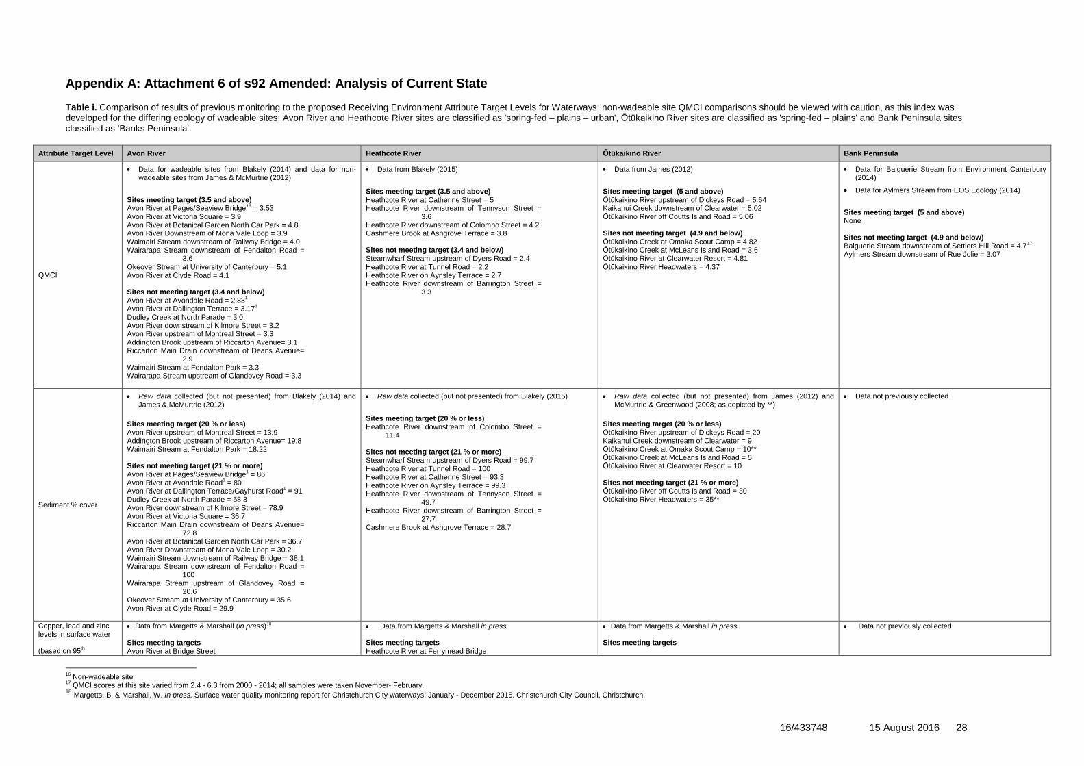
Appendix A: Attachment 6 of s92 Amended: Analysis of Current State Table i. Comparison of results of previous monitoring to the proposed Receiving Environment Attribute Target Levels for Waterways; non-wadeable site QMCI comparisons should be viewed with caution, as this index was developed for the differing ecology of wadeable sites; Avon River and Heathcote River sites are classified as 'spring-fed – plains – urban', Ōtūkaikino River sites are classified as 'spring-fed – plains' and Bank Peninsula sites classified as 'Banks Peninsula'.
Attribute Target Level Avon River Heathcote River Ōtūkaikino River Bank Peninsula
QMCI
• Data for wadeable sites from Blakely (2014) and data for non-wadeable sites from James & McMurtrie (2012)
Sites meeting target (3.5 and above) Avon River at Pages/Seaview Bridge16 = 3.53 Avon River at Victoria Square = 3.9 Avon River at Botanical Garden North Car Park = 4.8 Avon River Downstream of Mona Vale Loop = 3.9 Waimairi Stream downstream of Railway Bridge = 4.0 Wairarapa Stream downstream of Fendalton Road =
3.6 Okeover Stream at University of Canterbury = 5.1 Avon River at Clyde Road = 4.1 Sites not meeting target (3.4 and below) Avon River at Avondale Road = 2.831 Avon River at Dallington Terrace = 3.171 Dudley Creek at North Parade = 3.0 Avon River downstream of Kilmore Street = 3.2 Avon River upstream of Montreal Street = 3.3 Addington Brook upstream of Riccarton Avenue= 3.1 Riccarton Main Drain downstream of Deans Avenue=
2.9 Waimairi Stream at Fendalton Park = 3.3 Wairarapa Stream upstream of Glandovey Road = 3.3
• Data from Blakely (2015) Sites meeting target (3.5 and above) Heathcote River at Catherine Street = 5 Heathcote River downstream of Tennyson Street =
3.6 Heathcote River downstream of Colombo Street = 4.2 Cashmere Brook at Ashgrove Terrace = 3.8 Sites not meeting target (3.4 and below) Steamwharf Stream upstream of Dyers Road = 2.4 Heathcote River at Tunnel Road = 2.2 Heathcote River on Aynsley Terrace = 2.7 Heathcote River downstream of Barrington Street =
3.3
• Data from James (2012)
Sites meeting target (5 and above) Ōtūkaikino River upstream of Dickeys Road = 5.64 Kaikanui Creek downstream of Clearwater = 5.02 Ōtūkaikino River off Coutts Island Road = 5.06 Sites not meeting target (4.9 and below) Ōtūkaikino Creek at Omaka Scout Camp = 4.82 Ōtūkaikino Creek at McLeans Island Road = 3.6 Ōtūkaikino River at Clearwater Resort = 4.81 Ōtūkaikino River Headwaters = 4.37
• Data for Balguerie Stream from Environment Canterbury (2014)
• Data for Aylmers Stream from EOS Ecology (2014) Sites meeting target (5 and above) None Sites not meeting target (4.9 and below) Balguerie Stream downstream of Settlers Hill Road = 4.717 Aylmers Stream downstream of Rue Jolie = 3.07
Sediment % cover
• Raw data collected (but not presented) from Blakely (2014) and James & McMurtrie (2012)
Sites meeting target (20 % or less) Avon River upstream of Montreal Street = 13.9 Addington Brook upstream of Riccarton Avenue= 19.8 Waimairi Stream at Fendalton Park = 18.22 Sites not meeting target (21 % or more) Avon River at Pages/Seaview Bridge1 = 86 Avon River at Avondale Road1 = 80 Avon River at Dallington Terrace/Gayhurst Road1 = 91 Dudley Creek at North Parade = 58.3 Avon River downstream of Kilmore Street = 78.9 Avon River at Victoria Square = 36.7 Riccarton Main Drain downstream of Deans Avenue=
72.8 Avon River at Botanical Garden North Car Park = 36.7 Avon River Downstream of Mona Vale Loop = 30.2 Waimairi Stream downstream of Railway Bridge = 38.1 Wairarapa Stream downstream of Fendalton Road =
100 Wairarapa Stream upstream of Glandovey Road =
20.6 Okeover Stream at University of Canterbury = 35.6 Avon River at Clyde Road = 29.9
• Raw data collected (but not presented) from Blakely (2015)
Sites meeting target (20 % or less) Heathcote River downstream of Colombo Street =
11.4 Sites not meeting target (21 % or more) Steamwharf Stream upstream of Dyers Road = 99.7 Heathcote River at Tunnel Road = 100 Heathcote River at Catherine Street = 93.3 Heathcote River on Aynsley Terrace = 99.3 Heathcote River downstream of Tennyson Street =
49.7 Heathcote River downstream of Barrington Street =
27.7 Cashmere Brook at Ashgrove Terrace = 28.7
• Raw data collected (but not presented) from James (2012) and McMurtrie & Greenwood (2008; as depicted by **)
Sites meeting target (20 % or less) Ōtūkaikino River upstream of Dickeys Road = 20 Kaikanui Creek downstream of Clearwater = 9 Ōtūkaikino Creek at Omaka Scout Camp = 10** Ōtūkaikino Creek at McLeans Island Road = 5 Ōtūkaikino River at Clearwater Resort = 10 Sites not meeting target (21 % or more) Ōtūkaikino River off Coutts Island Road = 30 Ōtūkaikino River Headwaters = 35**
• Data not previously collected
Copper, lead and zinc levels in surface water (based on 95th
• Data from Margetts & Marshall (in press)18 Sites meeting targets Avon River at Bridge Street
• Data from Margetts & Marshall in press Sites meeting targets Heathcote River at Ferrymead Bridge
• Data from Margetts & Marshall in press Sites meeting targets
• Data not previously collected
16 Non-wadeable site 17 QMCI scores at this site varied from 2.4 - 6.3 from 2000 - 2014; all samples were taken November- February. 18 Margetts, B. & Marshall, W. In press. Surface water quality monitoring report for Christchurch City waterways: January - December 2015. Christchurch City Council, Christchurch.
16/433748 15 August 2016 29
Attribute Target Level Avon River Heathcote River Ōtūkaikino River Bank Peninsula percentiles, refer to the proposed conditions for the various targets, as the list is too long to include here)
Avon River at Pages/Seaview Bridge Avon River at Avondale Road Horseshoe Lake Discharge Dudley Creek at North Parade Avon River at Manchester Street Addington Brook Upstream of Riccarton Avenue Riccarton Main Drain Downstream of Deans Avenue Avon River at Carlton Mill Corner Avon River at Mona Vale Waimairi Stream Downstream of Railway Bridge Wairarapa Stream Downstream of Fendalton Road Sites not meeting target Avon River at Dallington Terrace/Gayhurst Road (zinc)
Heathcote River at Tunnel Road Heathcote River at Catherine Street Heathcote River at Opawa Road/Clarendon Terrace Heathcote River at Bowenvale Avenue Heathcote River at Ferniehurst Street Sites not meeting target None
Ōtūkaikino River at Groynes Inlet Sites not meeting target Wilsons Drain at Main North Road (zinc) Ōtūkaikino Creek at Omaka Scout Camp (zinc)
Macrophyte and filamentous algae % cover
• Data for wadeable sites from Blakely (2014) and for non-wadeable sites from James & McMurtrie (2012)
Macrophytes Sites meeting target (60 % or less) Avon River at Pages/Seaview Bridge1 = 36 Avon River at Avondale Road1 = 46 Avon River at Dallington Terrace/Gayhurst Road1 = 34 Dudley Creek at North Parade = 0 Avon River at Victoria Square = 38.3 Avon River upstream of Montreal Street = 0 Addington Brook upstream of Riccarton Avenue= 0 Riccarton Main Drain downstream of Deans Avenue=
5.7 Avon River at Botanical Garden North Car Park = 38.9 Avon River Downstream of Mona Vale Loop = 33.3 Waimairi Stream downstream of Railway Bridge = 5.6 Waimairi Stream at Fendalton Park = 0 Wairarapa Stream downstream of Fendalton Road =
28.3 Wairarapa Stream upstream of Glandovey Road = 3.9 Okeover Stream at University of Canterbury = 0 Avon River at Clyde Road = 19.6 Sites not meeting target (61 % and above) Avon River downstream of Kilmore Street = 93.8 Filamentous algae Sites meeting target (30 % or less) Avon River at Pages/Seaview Bridge1 = 2 Avon River at Avondale Road1 = 13 Dudley Creek at North Parade = 20 Avon River downstream of Kilmore Street = 14.9 Wairarapa Stream downstream of Fendalton Road = 0 Sites not meeting target (31 % and above) Avon River at Dallington Terrace/Gayhurst Road1 = 38 Avon River at Victoria Square near Armagh Street =
97.2 Avon River upstream of Montreal Street = 80 Addington Brook upstream of Riccarton Avenue= 93.4 Riccarton Main Drain downstream of Deans Avenue =
90.2 Avon River at Botanical Garden North Car Park = 64.4 Avon River Downstream of Mona Vale Loop = 40 Waimairi Stream downstream of Railway Bridge = 46.4 Waimairi Stream at Fendalton Park = 75.6 Wairarapa Stream upstream of Glandovey Road =
57.3 Okeover Stream at University of Canterbury = 39.6 Avon River at Clyde Road = 56.4
• Raw data collected (but not presented) from Blakely (2015) Macrophytes Sites meeting target (60 % or less) Steamwharf Stream upstream of Dyers Road = 5.7 Heathcote River at Tunnel Road19 = 0 Heathcote River at Catherine Street = 35.3 Heathcote River downstream of Tennyson Street =
25.7 Heathcote River downstream of Colombo Street =
10.3 Heathcote River downstream of Barrington Street = 7 Cashmere Brook at Ashgrove Terrace = 0.3 Sites not meeting target (61 % and above) Heathcote River on Aynsley Terrace = 77.3 Filamentous algae Sites meeting target (30 % or less) Heathcote River on Aynsley Terrace = 3.7 Sites not meeting target (31 % and above) Steamwharf Stream upstream of Dyers Road = 50.3 Heathcote River downstream of Tennyson Street =
61.7 Heathcote River downstream of Colombo Street =
49.3 Heathcote River downstream of Barrington Street =
90.3 Cashmere Brook at Ashgrove Terrace = 81.7
• Data from James (2012) Macrophytes Sites meeting target (50 % or less) Kaikanui Creek downstream of Clearwater = 17 Ōtūkaikino Creek at Omaka Scout Camp = 5 Ōtūkaikino Creek at McLeans Island Road = 20 Ōtūkaikino River at Clearwater Resort = 6 Ōtūkaikino River off Coutts Island Road = 17 Ōtūkaikino River Headwaters = 25 Sites not meeting target (51 % or more) Ōtūkaikino River upstream of Dickeys Road = 67 Filamentous algae Sites meeting target (30 % or less) Ōtūkaikino River upstream of Dickeys Road = 0 Kaikanui Creek downstream of Clearwater = 0 Ōtūkaikino Creek at Omaka Scout Camp = 0 Ōtūkaikino Creek at McLeans Island Road = 0 Ōtūkaikino River at Clearwater Resort = 0 Ōtūkaikino River off Coutts Island Road = 0 Ōtūkaikino River Headwaters = 0 Sites not meeting target (31 % or more) None
• Data for Aylmers Stream from EOS Ecology (2014) • Data not previously collected for all other sites and
parameters Macrophytes Sites meeting target (30 % or less) • Aylmers Stream Downstream of Rue Jolie = 0 Sites not meeting target (31 % or more) None
Copper, lead, zinc and PAH levels in sediment
• Raw data from Gadd & Sykes (2014)
• Raw data from Gadd (2015)
• Data from Whyte (2014)
• Data not previously collected
19 Macrophyte cover could not be determined at two of three locations at this site, only the one location where data was able to be collected is presented
16/433748 15 August 2016 30
Attribute Target Level Avon River Heathcote River Ōtūkaikino River Bank Peninsula Copper Sites meeting target (65 mg/kg or less) Avon River at Bridge Street = 21 Avon River at Pages/Seaview Bridge = 18.6 Avon River at Avondale Road = 31 Avon River at Dallington Terrace = 12.8 Dudley Creek at North Parade = 14.2 Avon River at Manchester Street = 24 Avon River at Victoria Square = 12.7 Addington Brook upstream of Riccarton Avenue= 18.9 Riccarton Main Drain downstream of Deans Avenue=
34 Avon River at Carlton Mill Corner = 7.3 Avon River at Mona Vale = 13.2 Waimairi Stream downstream of Railway Bridge = 9.8 Wairarapa Stream downstream of Fendalton Road =
14.9 Avon River at Clyde Road = 11.8 Sites not meeting target (66 mg/kg or more) None Lead Sites meeting target (50 mg/kg or less) Avon River at Bridge Street = 34 Avon River at Pages/Seaview Bridge = 35 Avon River at Dallington Terrace/Gayhurst Road = 48 Avon River at Victoria Square near Armagh St = 35 Avon River at Carlton Mill Corner = 18 Avon River at Mona Vale = 37 Waimairi Stream downstream of Railway Bridge = 30 Avon River at Clyde Road = 29 Sites not meeting target (51 mg/kg or more) Avon River at Avondale Road = 64 Dudley Creek at North Parade = 111 Avon River at Manchester Street = 57 Addington Brook upstream of Riccarton Avenue= 62 Riccarton Main Drain downstream of Deans Avenue=
67 Wairarapa Stream downstream of Fendalton Road =
54 Zinc Sites meeting target (200 mg/kg or less) Avon River at Bridge Street = 128 Avon River at Pages/Seaview Bridge = 134 Avon River at Dallington Terrace/Gayhurst Road = 178 Dudley Creek at North Parade = 172 Avon River at Victoria Square = 149 Avon River at Carlton Mill Corner = 76 Avon River at Mona Vale = 143 Waimairi Stream downstream of Railway Bridge = 94 Wairarapa Stream downstream of Fendalton Road =
119 Avon River at Clyde Road = 187 Sites not meeting target (201 mg/kg or more) Avon River at Avondale Road = 365 Avon River at Manchester Street = 230 Addington Brook upstream of Riccarton Avenue= 500 Riccarton Main Drain downstream of Deans Avenue=
330 PAH Sites meeting target (10 mg/kg or less) Avon River at Bridge Street = 1.7 Avon River at Pages/Seaview Bridge = 1.7 Avon River at Avondale Road = 7.2 Avon River at Victoria Square near Armagh St = 9.2 Addington Brook upstream of Riccarton Avenue= 2.1 Riccarton Main Drain downstream of Deans Avenue=
6.7
Copper Sites meeting target (65 mg/kg or less) Heathcote River at Tunnel Road = 18.5 Heathcote River at Catherine Street = 24 Heathcote River downstream of Tennyson Street=
13.9 Heathcote River downstream of Colombo Street =
17.5 Heathcote River downstream of Barrington Street = 9 Sites not meeting target (66 mg/kg or more) None Lead Sites meeting target (50 mg/kg or less) Heathcote River at Tunnel Road = 29 Heathcote River downstream of Tennyson Street = 21 Heathcote River downstream of Colombo Street = 36 Sites not meeting target (51 mg/kg or more) Heathcote River at Catherine Street = 64 Heathcote River downstream of Barrington Street =
136 Zinc Sites meeting target (200 mg/kg or less) Heathcote River at Tunnel Road = 183 Heathcote River downstream of Tennyson Street =
163 Heathcote River downstream of Barrington Street =
148 Sites not meeting target (201 mg/kg or more) Heathcote River at Catherine Street = 300 Heathcote River downstream of Colombo Street = 230 PAH Sites meeting target (10 mg/kg or less) Heathcote River at Tunnel Road = 5.7 Heathcote River downstream of Tennyson Street =
3.1 Heathcote River downstream of Barrington Street =
9.8 Sites not meeting target (10.1 mg/kg or more) Heathcote River at Catherine Street = 30.9 Heathcote River downstream of Colombo Street = 212
Copper Sites meeting target (65 mg/kg or less) Wilsons Drain at Main North Road = 36 Sites not meeting target (66 mg/kg or more) None Lead Sites meeting target (50 mg/kg or less) Wilsons Drain at Main North Road = 47 Sites not meeting target (51 mg/kg or more) None Zinc Sites meeting target (200 mg/kg or less) None Sites not meeting target (201 mg/kg or more) Wilsons Drain at Main North Road = 340 PAH Sites meeting target (10 mg/kg or less) Wilsons Drain at Main North Road = 0.53 Sites not meeting target (10.1 mg/kg or more) None
16/433748 15 August 2016 31
Attribute Target Level Avon River Heathcote River Ōtūkaikino River Bank Peninsula Avon River at Mona Vale = 2.5 Waimairi Stream downstream of Railway Bridge = 6.2 Avon River at Clyde Road = 2.1 Sites not meeting target (10.1 mg/kg or more) Avon River at Dallington Terrace = 10.2 Dudley Creek at North Parade = 263.820 Avon River at Manchester Street = 15 Avon River at Carlton Mill Corner = 10.6 Wairarapa Stream downstream of Fendalton Road =
14
Waterway Cultural Health Index and State of Takiwā scores
• Data not previously collected in that manner • Data not previously collected in that manner • Data not previously collected in that manner • Data not previously collected in that manner
20 Initially this result was recorded as 505.8 mg/kg, but additional tests showed concentrations were highly variable, with reanalysis producing 21.8 mg/kg: the figure presented is the mean of these two values.
16/433748 15 August 2016 32
Appendix B: Greenfield Development Areas Discharging to Land – Halswell River Catchment


![Apostila Cursos CRC - Administração de Departamento Pessoal CRC[1]](https://img.pdfslide.net/doc/110x75/5571f85049795991698d254a/apostila-cursos-crc-administracao-de-departamento-pessoal-crc1.jpg)