Embed Size (px)
Citation preview

AGRICULTURE RESEARCH GROUP
INDIA HEADQUARTERS
G 31 Quest Off ices
DLF Golf Course Road
Gurgaon 122 002 India
RESEARCH CENTER
SIDBI Innovation Center
I IT Kanpur
Kanpur 208 016 India
NORTH AMERICA
350 Fif th Avenue
59 th Floor, New York City
NY 10118 USA
Crop Acreage and Yield
Estimation Report(2nd) - Banda

• Acreage under Wheat seems to have Increased in 2015-16
with comparing to Akchhadan report statistics released by
Agriculture Ministry (2015-16).
• Yield estimates are made from satellite derived Normalized
Difference Vegetation Index.
• NDVI in the month of March 2016 is normal except Jaspura
and Mahuva blocks for Wheat crop as compared to 2015.
• Overall NDVI suggest that there may be normal crop growth in
the District.
S u m m a r y We a t h er
F o r e c as t
Ac r e a g e
E s t i m at i o n
Yi e l d
E s t i m at i o n
Executive Summary

GFS-(Tmax & Tmin)
• Tmax and Tmin Forecast Maps upto (22nd March 2016)
S u m m a r y We a t h er
F o r e c as t
Ac r e a g e
E s t i m at i o n
Yi e l d
E s t i m at i o n

GFS-(Rain & Temp) March2016
Block Name TMIN TMAX Rain
Baberu 32.4 27.8 0.4
Badokhar Khurd 32.5 28.0 0.4
Bisanda 32.3 27.8 0.3
Jaspura 32.3 27.5 0.3
Kamasin 32.4 27.8 0.3
Mahuva 32.2 27.7 0.2
Naraini 31.9 27.3 0
Tindwari 32.4 27.7 0.3
• Block wise weather forecast data upto 22march2016
S u m m a r y We a t h er
F o r e c as t
Ac r e a g e
E s t i m at i o n
Yi e l d
E s t i m at i o n

Crop Area(2015-16)
• Wheat cropped area by satellite
S u m m a r y We a t h er
F o r e c as t
Ac r e a g e
E s t i m at i o n
Yi e l d
E s t i m at i o n
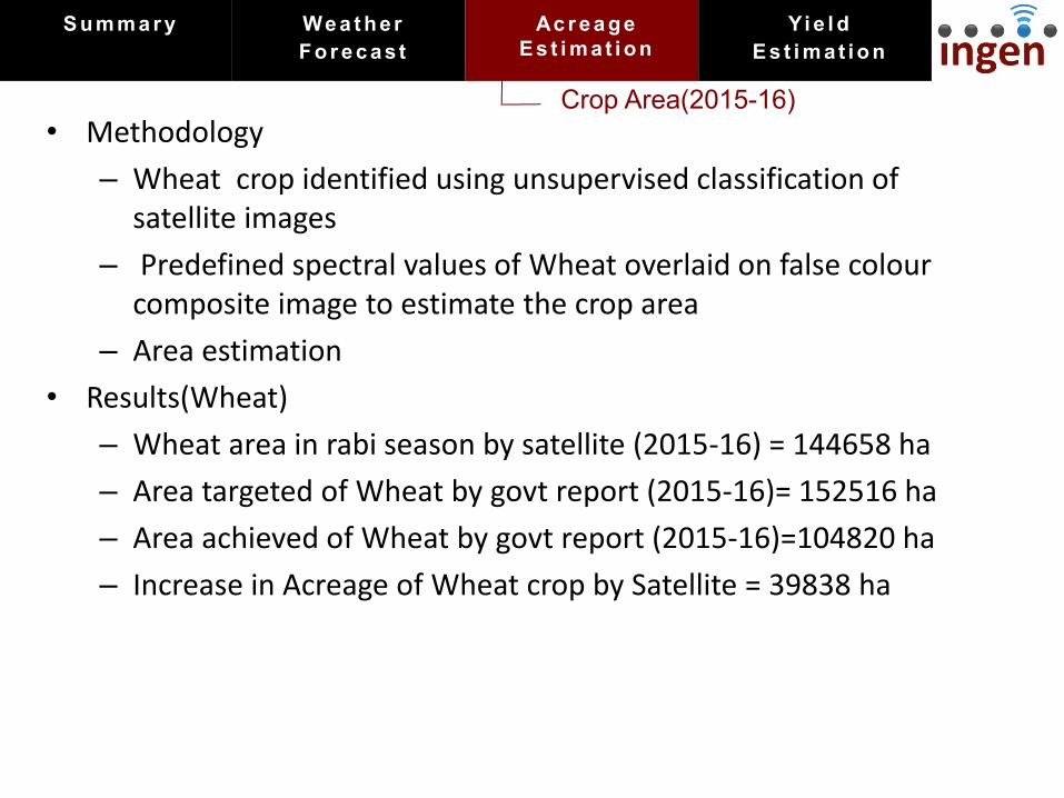
Crop Area(2015-16)
• Methodology
– Wheat crop identified using unsupervised classification of
satellite images
– Predefined spectral values of Wheat overlaid on false colour
composite image to estimate the crop area
– Area estimation
• Results(Wheat)
– Wheat area in rabi season by satellite (2015-16) = 144658 ha
– Area targeted of Wheat by govt report (2015-16)= 152516 ha
– Area achieved of Wheat by govt report (2015-16)=104820 ha
– Increase in Acreage of Wheat crop by Satellite = 39838 ha
S u m m a r y We a t h er
F o r e c as t
Ac r e a g e
E s t i m at i o n
Yi e l d
E s t i m at i o n

NDVI Maps
Satellite Image - Feb 2015 vs Feb 2016
S u m m a r y We a t h er
F o r e c as t
Ac r e a g e
E s t i m at i o n
Yi e l d
E s t i m at i o n

NDVI Values
• NDVI was low in the month of February 2016 as compared to
Feb 2015 in all blocks
Block NDVI (Feb)
2015 2016
Baberu 0.30 0.21
Badokhar Khurd 0.29 0.15
Bisanda 0.31 0.23
Jaspura 0.26 0.18
Kamasin 0.27 0.18
Mahuva 0.30 0.19
Naraini 0.27 0.18
Tindwari 0.30 0.22
S u m m a r y We a t h er
F o r e c as t
Ac r e a g e
E s t i m at i o n
Yi e l d
E s t i m at i o n
NDVI Maps
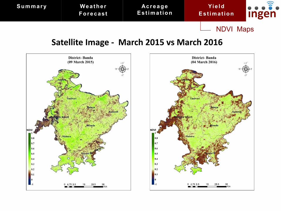
Satellite Image - March 2015 vs March 2016
S u m m a r y We a t h er
F o r e c as t
Ac r e a g e
E s t i m at i o n
Yi e l d
E s t i m at i o n

NDVI Values
• NDVI is normal in the month of March 2016 except Jaspura
and Mahuva blocks
Block NDVI (March)
2015 2016
Baberu 0.25 0.24
Badokhar Khurd 0.21 0.20
Bisanda 0.27 0.26
Jaspura 0.26 0.21
Kamasin 0.24 0.21
Mahuva 0.28 0.24
Naraini 0.22 0.20
Tindwari 0.27 0.25
S u m m a r y We a t h er
F o r e c as t
Ac r e a g e
E s t i m at i o n
Yi e l d
E s t i m at i o n
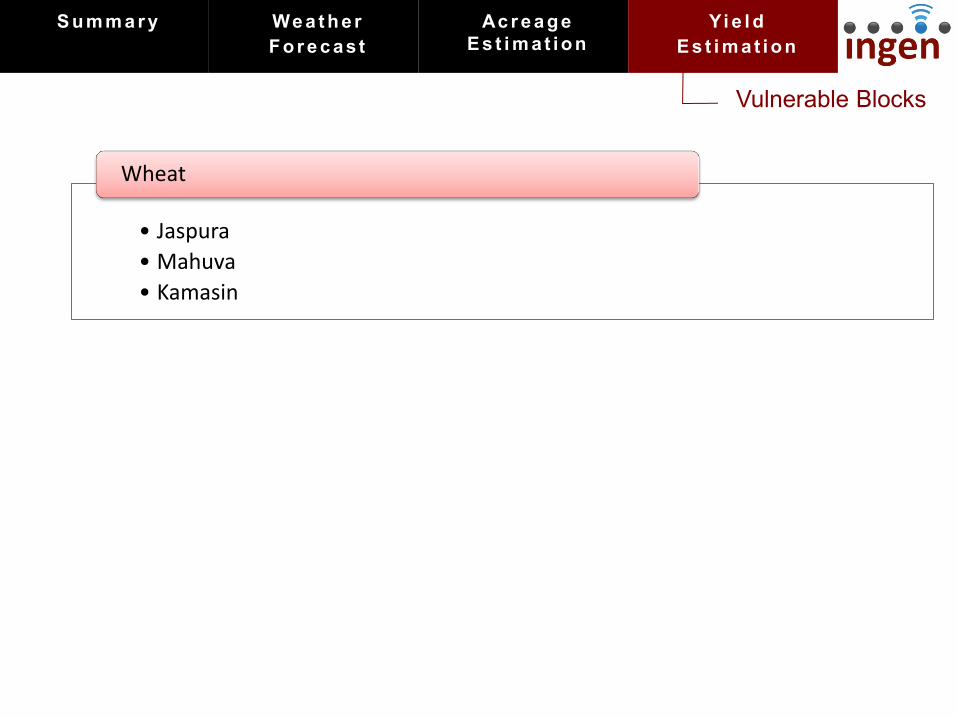
Vulnerable Blocks
• Jaspura
• Mahuva
• Kamasin
Wheat
S u m m a r y We a t h er
F o r e c as t
Ac r e a g e
E s t i m at i o n
Yi e l d
E s t i m at i o n

AGRICULTURE RESEARCH GROUP
INDIA HEADQUARTERS
G 31 Quest Off ices
DLF Golf Course Road
Gurgaon 122 002 India
GLOBAL RESEARCH CENTER
SIDBI Innovation Center
Indian Inst itute of Technology
Kanpur 208 016 India
NORTH AMERICA
350 Fif th Avenue
59 th Floor, New York City
NY 10118 USA
Thank You * Join our mission to provide climate security to all *


![Full page photo€¦ · 3.70 0.18 Õnsnà21_yuãunuaamÜFJ+FJanSnaàouuaouaaäu 0.06 uaìnmuuouïf[fapãu [cnn) rillsansfapãu (UT] 4.76 0.70 comp úuÜuuafañu [l_nnl o .30 0.18](https://img.pdfslide.net/doc/110x75/5f28ea5db7be101d2346532e/full-page-photo-370-018-nsn21yuunuaamoefjfjansnaouuaouaau-006-uanmuuouffapu.jpg)