Embed Size (px)
Citation preview
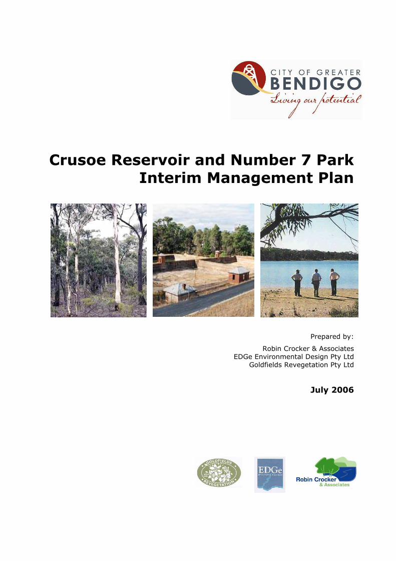
Crusoe Reservoir and Number 7 Park
Interim Management Plan
Prepared by:
Robin Crocker & Associates EDGe Environmental Design Pty Ltd
Goldfields Revegetation Pty Ltd
July 2006
Crusoe Reservoir and Number 7 Park Interim Management Plan
Prepared by
� Robin Crocker & Associates Robin Crocker Ph 9830 2242
� EDGe Environmental Design Pty Ltd
David Abbott Ph 9329 7512
� Goldfields Revegetation Pty Ltd Marilyn Sprague Ph 5439 5384
© City of Greater Bendigo
July 2006
Acknowledgements
We acknowledge the valuable assistance of the project steering committee and staff from the City of Greater Bendigo, Coliban Water, CFA, EPA, Parks Victoria, Heritage Victoria, Dept of Sustainability and Environment, Life Saving Victoria and other interested organisations and individuals.
Photographs: Robin Crocker
This publication provides information of a general nature and more detailed investigation and design will be required before site development works can be undertaken.
crusoe no 7 plan aug15 06
Crusoe Reservoir and No 7 Park Interim Management Plan 2006 Robin Crocker & Associates 3
Contents Summary .................................................................................................... 5 1 Introduction......................................................................................... 6 1.1 The study area................................................................................ 6 1.2 Previous planning and the purpose of this plan .................................... 7 1.3 The planning process ....................................................................... 7 1.4 Constraints..................................................................................... 7 1.5 The next steps ................................................................................ 9
2 Basis for the plan............................................................................... 10 3 Site values, conditions and issues...................................................... 11 3.1 Values and conditions .................................................................... 11 3.2 Important issues ........................................................................... 12
4 Vision, principles and goals ............................................................... 13 4.1 Vision and future directions for the area ........................................... 13 4.2 Planning and management principles ............................................... 13 4.3 Key goals ..................................................................................... 14 4.4 Management zones........................................................................ 14
5 Actions to achieve the key goals........................................................ 16 5.1 Goal 1: Develop access and informal recreation facilities at Number 7 Reservoir ............................................................................................... 16
5.1.1 Vehicle entry and access.......................................................... 16 5.1.2 Parking ................................................................................. 16 5.1.3 Walking tracks........................................................................ 17 5.1.4 Picnic and other facilities.......................................................... 17 5.1.5 User safety and risk management ............................................. 18 5.1.6 Regulations, dogs ................................................................... 18 5.1.7 Fees ..................................................................................... 18
5.2 Goal 2: Develop access and informal recreation facilities at Crusoe Reservoir ............................................................................................... 19
5.2.1 Vehicle entry and access.......................................................... 19 5.2.2 Parking ................................................................................. 20 5.2.3 Swimming area and water access.............................................. 21 5.2.4 Short-term facilities and activities ............................................. 23 5.2.5 Walking, bicycle and other tracks .............................................. 25 5.2.6 User safety, water quality and risk management ......................... 26 5.2.7 Regulations, dogs ................................................................... 27 5.2.8 Fees ..................................................................................... 27
5.3 Goal 3: Maintain and protect natural and cultural values ..................... 28 5.3.1 Vegetation ............................................................................. 28 5.3.2 Fauna ................................................................................... 30 5.3.3 Fire....................................................................................... 31 5.3.4 Geology, soils, erosion and run-off ............................................ 31 5.3.5 Cultural values ....................................................................... 33
5.4 Goal 4: Provide effective and sustainable management, compatible with Bendigo Regional Park and Greater Bendigo National Park............................. 35
5.4.1 Management responsibility ....................................................... 35 5.4.2 Sustainable management......................................................... 36
5.5 Goal 5: Promote community involvement, appreciation and use........... 37 5.5.1 Community involvement in the area .......................................... 37

Crusoe Reservoir and No 7 Park Interim Management Plan 2006 Robin Crocker & Associates 4
5.5.2 Promotion.............................................................................. 37 5.5.3 Information............................................................................ 37 5.5.4 Interpretation and education .................................................... 38
6 Implementing the plan ...................................................................... 40 6.1 Priority action plan ........................................................................ 40 6.2 Resources and staging ................................................................... 40 6.3 Monitoring performance ................................................................. 41
7 References......................................................................................... 45 Appendices ............................................................................................... 46
Appendix 1 Steering Committee.......................................................... 46 Appendix 2 Existing policies and strategies........................................... 47 Appendix 3 Crusoe and No. 7 Reservoirs Risk Assessment ...................... 48 Appendix 4 Details of option for beach development .............................. 50 Appendix 5 Plant list, Crusoe Reservoir ................................................ 56
Figures
1. Locality plan 6 2. Overall Site Development Plan end of plan 3. Number 7 Park Activity Area Development Plan end of plan 4. Crusoe Entrance Development Plan end of plan 5. Vegetation Plan end of plan Tables
1. Broad staging program 37 2. Priority action program 39
Crusoe Reservoir and No 7 Park Interim Management Plan 2006 Robin Crocker & Associates 5
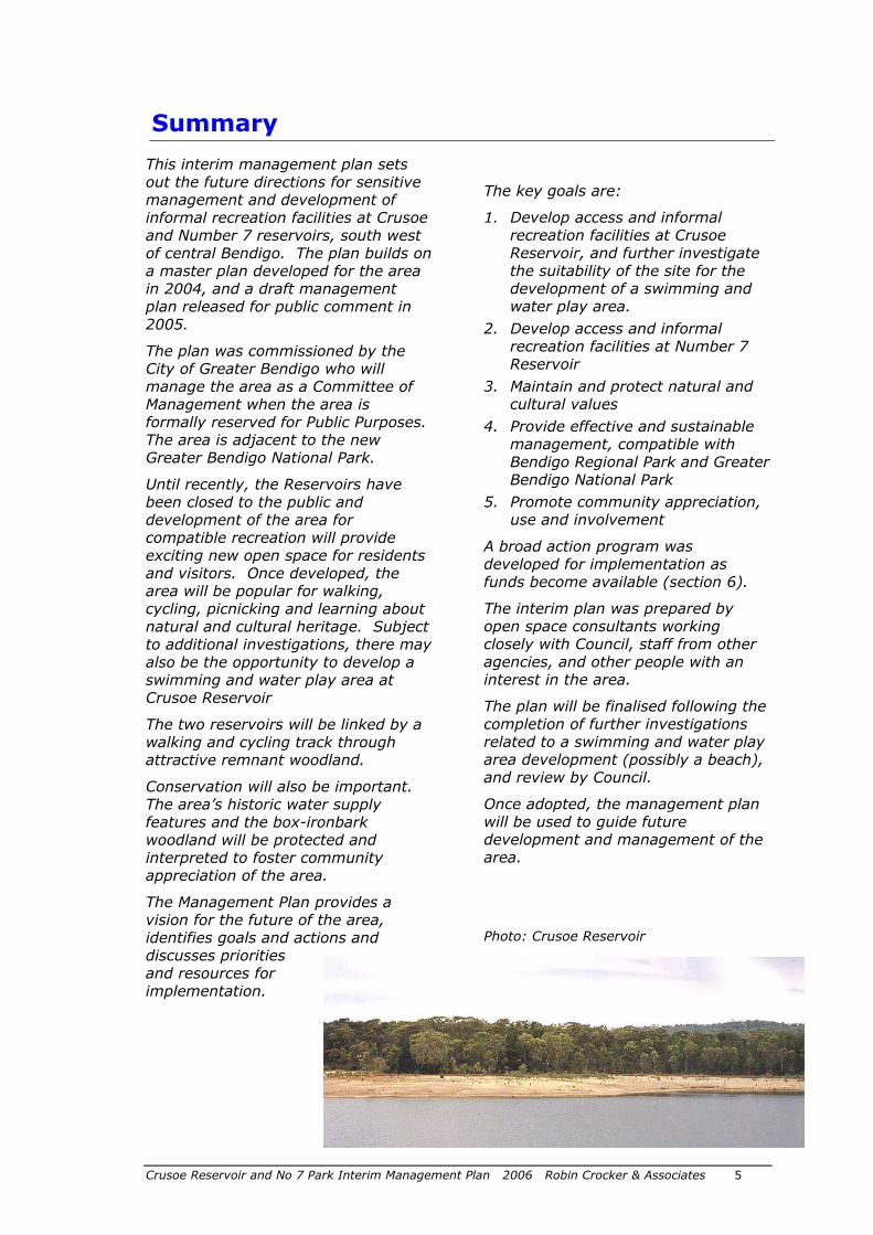
This interim management plan sets out the future directions for sensitive management and development of informal recreation facilities at Crusoe and Number 7 reservoirs, south west of central Bendigo. The plan builds on a master plan developed for the area in 2004, and a draft management plan released for public comment in 2005.
The plan was commissioned by the City of Greater Bendigo who will manage the area as a Committee of Management when the area is formally reserved for Public Purposes. The area is adjacent to the new Greater Bendigo National Park.
Until recently, the Reservoirs have been closed to the public and development of the area for compatible recreation will provide exciting new open space for residents and visitors. Once developed, the area will be popular for walking, cycling, picnicking and learning about natural and cultural heritage. Subject to additional investigations, there may also be the opportunity to develop a swimming and water play area at Crusoe Reservoir
The two reservoirs will be linked by a walking and cycling track through attractive remnant woodland.
Conservation will also be important. The area’s historic water supply features and the box-ironbark woodland will be protected and interpreted to foster community appreciation of the area.
The Management Plan provides a vision for the future of the area, identifies goals and actions and discusses priorities and resources for implementation.
The key goals are:
1. Develop access and informal recreation facilities at Crusoe Reservoir, and further investigate the suitability of the site for the development of a swimming and water play area.
2. Develop access and informal recreation facilities at Number 7 Reservoir
3. Maintain and protect natural and cultural values
4. Provide effective and sustainable management, compatible with Bendigo Regional Park and Greater Bendigo National Park
5. Promote community appreciation, use and involvement
A broad action program was developed for implementation as funds become available (section 6).
The interim plan was prepared by open space consultants working closely with Council, staff from other agencies, and other people with an interest in the area.
The plan will be finalised following the completion of further investigations related to a swimming and water play area development (possibly a beach), and review by Council.
Once adopted, the management plan will be used to guide future development and management of the area.
Photo: Crusoe Reservoir
Summary
Crusoe Reservoir and No 7 Park Interim Management Plan 2006 Robin Crocker & Associates 6
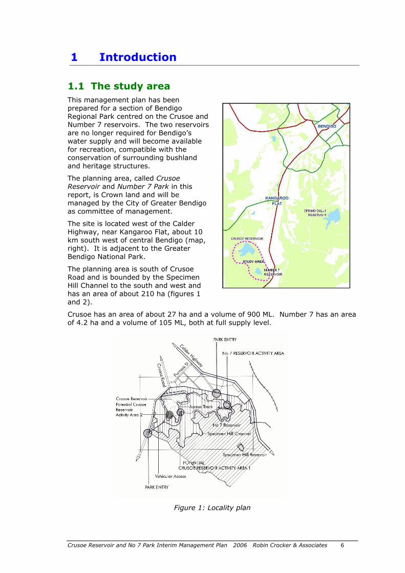
1.1 The study area
This management plan has been prepared for a section of Bendigo Regional Park centred on the Crusoe and Number 7 reservoirs. The two reservoirs are no longer required for Bendigo’s water supply and will become available for recreation, compatible with the conservation of surrounding bushland and heritage structures.
The planning area, called Crusoe Reservoir and Number 7 Park in this report, is Crown land and will be managed by the City of Greater Bendigo as committee of management.
The site is located west of the Calder Highway, near Kangaroo Flat, about 10 km south west of central Bendigo (map, right). It is adjacent to the Greater Bendigo National Park.
The planning area is south of Crusoe Road and is bounded by the Specimen Hill Channel to the south and west and has an area of about 210 ha (figures 1 and 2).
Crusoe has an area of about 27 ha and a volume of 900 ML. Number 7 has an area of 4.2 ha and a volume of 105 ML, both at full supply level.
Figure 1: Locality plan
1 Introduction
Crusoe Reservoir and No 7 Park Interim Management Plan 2006 Robin Crocker & Associates 7
1.2 Previous planning and the purpose of this plan
The City of Greater Bendigo commissioned a Concept Plan for the area surrounding the Crusoe and Number 7 reservoirs in 1999 (RCA 1999), and a Master Plan in 2004 (RCA 2004).
The Master Plan proposed development for swimming and other compatible recreation activities at Crusoe reservoir and low-key picnic facilities at Number 7 reservoir (in accordance with earlier Environment Conservation Council recommendations). Separate road access was proposed to the two sites with walking/bicycle tracks linking points of interest. Roads, tracks, parking areas and other facilities were to be located largely in cleared areas to minimise impacts on sensitive soils and vegetation. Subsequent to completion of the plan, the need for additional investigation of water levels and water quality was identified.
This interim management plan has been commissioned by Council to undertake further investigation of some major issues, ensure sustainable management of the area and document environmental management and other management activities in greater detail.
1.3 The planning process
Consultants worked closely with a project steering committee to develop the plan. The committee included representatives from Council, Coliban Water, the Department of Sustainability and Environment (DSE), Heritage Victoria and Parks Victoria.
The planning process included review of important issues such as risk management, water levels, water quality, recreational uses, heritage protection, provision of services and vegetation management. On-site tasks included assessment of vegetation quality and protection, water flows and drainage, and review of the location of access roads and tracks.
A detailed assessment of heritage and interpretation issues at Number 7 Reservoir was also undertaken during the study and the recommendations incorporated in this plan. The report by Rob Kaufman of LRGM Services: Cultural Heritage & Interpretation Statement – No 7 Reservoir, for City of Greater Bendigo, 2005, should be read in conjunction with this report.
A draft management plan was released for public comment in November-December 2005 and a successful open day held on site. Fourteen written submissions and several informal comments were received and 220 people attended the open day. All comments received were carefully considered by Council and a series of amendments made.
1.4 Constraints
Initial assessments indicated that water flows from the local catchment would be adequate to maintain suitable levels for beach use at Crusoe Reservoir in most seasons, and that water quality would continue to be suitable for the proposed water-based uses.
Some concerns have since been raised about water levels and water quality, and possible environmental impacts of facility construction. Additional investigation of these issues is needed to ensure that any decision regarding facility development is based on up to date information.

Crusoe Reservoir and No 7 Park Interim Management Plan 2006 Robin Crocker & Associates 8
Development of the Number 7 area and informal recreation facilities at Crusoe Reservoir can proceed independently of a swimming and water play area at Crusoe. The development of facilities will be subject to adequate funding.
Crusoe Reservoir and No 7 Park Interim Management Plan 2006 Robin Crocker & Associates 9
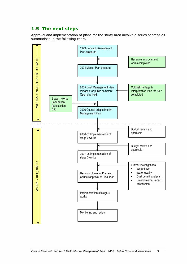
1.5 The next steps
Approval and implementation of plans for the study area involve a series of steps as summarised in the following chart.
……………..…………………………………………………………………………………
1999 Concept Development Plan prepared
Reservoir improvement works completed
Cultural Heritage & Interpretation Plan for No 7 completed
Stage 1 works undertaken (see section 6.2)
WORKS U
NDERTAKEN T
O D
ATE
WORKS R
EQUIR
ED
2004 Master Plan prepared
2005 Draft Management Plan released for public comment. Open day held.
2006 Council adopts Interim Management Plan
2006-07 Implementation of stage 2 works
2007-08 Implementation of stage 3 works
Revision of Interim Plan and Council approval of Final Plan
Implementation of stage 4 works
Monitoring and review
Budget review and approvals
Budget review and approvals
Further investigations:
• Water flows
• Water quality
• Cost benefit analysis
• Environmental impact assessment
Crusoe Reservoir and No 7 Park Interim Management Plan 2006 Robin Crocker & Associates 10
The Environment Conservation Council (ECC 2001 p.155-6) stated that ‘Crusoe in particular has high potential for passive water-based recreation [and] could be managed separately from the recommended regional park as a community recreation and tourism focus point.’ The ECC recommended a range of recreation and educational activities in the Bendigo Regional Park combined with protection of biodiversity and natural features, and protection of significant historic sites and Aboriginal places.
This plan builds on these opportunities, recognising the benefits of open space identified in a wide range of studies. The development of the management plan was recognised as important in the City’s draft Open Space Strategy (COGB 2004, vol 2, p 16). Development of the site was also recommended in this strategy (Recommendation 2.24).
The plan is based in part on existing state legislation and council policies, the established benefits of open space and recent trends in open space use.
Existing policies and strategies
In addition to the ECC recommendations (see above), a range of statewide legislation and policies influence the management of the study area (appendix 2). These documents all support the provision of recreational opportunities compatible with the protection of natural and cultural values.
Benefits of open space
The benefits of open space are considerable and have been well documented. The state government’s Active for Life initiative (SRV 2000) recognises the benefits of open space use and promotes increased physical activity, particularly sport and outdoor recreation, with more bicycle facilities, improved access to open space and improved pedestrian safety. The Heart Foundation has also produced a useful guide to healthy outdoor design (Heart Foundation 2004).
The current ‘Healthy Parks, Healthy People’ program developed by Parks Victoria and widespread publicity on lack of exercise and obesity have also helped focus on the opportunities to expand open space networks and increase active recreational activities including walking, recreational cycling and swimming.
Important benefits of open space identified include:
• Improved health and wellbeing.
• Providing settings for recreation, relaxing, children’s play and socialising with family, friends and groups.
• Conserving natural and cultural values and providing wildlife habitat.
• Assisting child development including creativity and nature appreciation.
• Enhancing a municipality’s community identity, pride and visual amenity.
Open space trends
Some of the important trends relevant to the study area are listed here. These are based on the outcomes of a series of Victorian municipal park and open space studies.
• Recognised need to encourage healthy lifestyles including increased use of open space.
• Expectations of high quality facilities, settings and maintenance.
• Greater emphasis on equitable access and user safety.
• Increased interest in natural and cultural values and commitment to ecologically sustainable management and development
2 Basis for the plan
Crusoe Reservoir and No 7 Park Interim Management Plan 2006 Robin Crocker & Associates 11
Current site values and conditions and the main issues to be addressed in the plan are summarised in this section. Further details are provided in section 5.
3.1 Values and conditions
Natural and landscape values
The Bendigo Regional Park has high natural values. The park and adjoining public land support populations of several threatened species (EEC 2001).
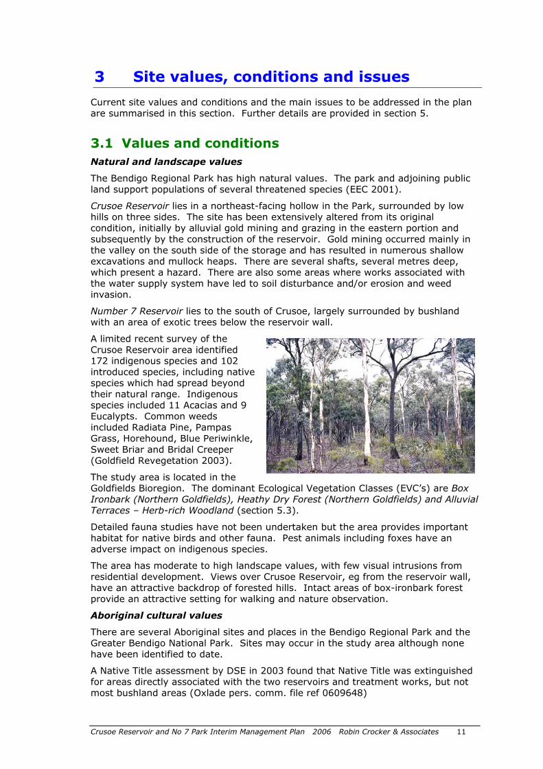
Crusoe Reservoir lies in a northeast-facing hollow in the Park, surrounded by low hills on three sides. The site has been extensively altered from its original condition, initially by alluvial gold mining and grazing in the eastern portion and subsequently by the construction of the reservoir. Gold mining occurred mainly in the valley on the south side of the storage and has resulted in numerous shallow excavations and mullock heaps. There are several shafts, several metres deep, which present a hazard. There are also some areas where works associated with the water supply system have led to soil disturbance and/or erosion and weed invasion.
Number 7 Reservoir lies to the south of Crusoe, largely surrounded by bushland with an area of exotic trees below the reservoir wall.
A limited recent survey of the Crusoe Reservoir area identified 172 indigenous species and 102 introduced species, including native species which had spread beyond their natural range. Indigenous species included 11 Acacias and 9 Eucalypts. Common weeds included Radiata Pine, Pampas Grass, Horehound, Blue Periwinkle, Sweet Briar and Bridal Creeper (Goldfield Revegetation 2003).
The study area is located in the Goldfields Bioregion. The dominant Ecological Vegetation Classes (EVC’s) are Box Ironbark (Northern Goldfields), Heathy Dry Forest (Northern Goldfields) and Alluvial Terraces – Herb-rich Woodland (section 5.3).
Detailed fauna studies have not been undertaken but the area provides important habitat for native birds and other fauna. Pest animals including foxes have an adverse impact on indigenous species.
The area has moderate to high landscape values, with few visual intrusions from residential development. Views over Crusoe Reservoir, eg from the reservoir wall, have an attractive backdrop of forested hills. Intact areas of box-ironbark forest provide an attractive setting for walking and nature observation.
Aboriginal cultural values
There are several Aboriginal sites and places in the Bendigo Regional Park and the Greater Bendigo National Park. Sites may occur in the study area although none have been identified to date.
A Native Title assessment by DSE in 2003 found that Native Title was extinguished for areas directly associated with the two reservoirs and treatment works, but not most bushland areas (Oxlade pers. comm. file ref 0609648)
3 Site values, conditions and issues
Crusoe Reservoir and No 7 Park Interim Management Plan 2006 Robin Crocker & Associates 12
Historic values
The main historic features of the site are the Number 7 Reservoir built in 1859 and associated filter beds and underground water storage, the Crusoe Reservoir built in Robinson Crusoe Gully in 1873 and associated settling ponds, and also a complex aqueduct, siphon and channel system including the main supply channel from Malmsbury. The system was designed by the notable civil engineer, Joseph Brady, and is regarded as one of the most intact and important early water supply systems in Australia. See also the report by Kaufman (2005).
Much of the site is on the Victorian Heritage Register (Number H1021) giving it the highest level of protection available.
Recreational values and current use
The study area is currently fenced and access is discouraged but it does have some recreational use including walking, fishing and damaging trail bike riding.
3.2 Important issues
Field assessments and consultation with the project steering committee and other stakeholders identified the following important issues for the future development of the study area for community use.
Recreation
• Providing low-impact access roads and parking.
• Pending the outcome of further investigations, provide swimming and water play area with water interface at Crusoe Reservoir.
• Providing low-key recreation opportunities and facilities at Number 7 Reservoir.
• Providing walking and cycling opportunities in the area.
• Catering for all, including people with disabilities.
• Interpreting cultural and historic values, particularly the water supply system.
Conservation
• Minimising impacts of development and recreational use on flora, fauna and soils.
• Improving water availability below Specimen Hill Channel, but minimising runoff of sediment and debris into Crusoe Reservoir.
• Improving the quality of vegetation through weed control and revegetation.
• Protecting historic and cultural heritage values.
Management
• Ensuring adequate water inflow and water quality in Crusoe Reservoir.
• Minimising risks to visitors and other stakeholders.
• Providing adequate resources and expertise for development and management.
Crusoe Reservoir and No 7 Park Interim Management Plan 2006 Robin Crocker & Associates 13
4.1 Vision and future directions for the area
The following vision was developed for the study area.
Vision
By 2010, Crusoe Reservoir and Number 7 Park have become popular informal recreation sites for Bendigo residents and other visitors. The parks are popular for walking, cycling, picnicking, relaxing, sightseeing and learning about natural and cultural values. Fishing is also popular at Crusoe and young people from Bendigo learn basic sailing skills on the reservoir.
Sensitively designed parking, picnic and toilet facilities blend with the surrounding woodland at Crusoe and walking tracks provide regulated access through bushland areas to Number 7 Reservoir and interesting heritage features including some of the oldest water supply structures surviving in Victoria.
A small visitor area developed at Number 7 Reservoir is popular with people who enjoy picnicking, walking, bird watching and heritage interpretation in a peaceful setting.
Invasive weeds have been effectively controlled, soil erosion ameliorated and regeneration of indigenous flora enhanced, improving habitat for wildlife.
The well-managed Crusoe Reservoir and Number 7 Park have become popular destinations in the Bendigo Regional Park and a source of pride for the Bendigo community.
Further investigations have been undertaken to help decide if a swimming and water play area should be constructed at Crusoe Reservoir.
4.2 Planning and management principles
The following principles provide guidance for the future planning, design and management of the study area. They have been developed from other park and open space studies and emphasise a diversity of recreation experience, quality of settings, good access and maintenance, and protection of natural and cultural values.
Guiding principles for Crusoe Reservoir and Number 7 Park development
Access and equity
• Provide good access to facilities for all including people with disabilities.
• Provide a range of settings and activities for different age groups, males and females, and other groups in the community.
• Promote use of the area and the benefits of recreation.
Diversity, quality and design
• Provide high quality design, layout and facilities for safe and enjoyable use.
4 Vision, principles and goals
Crusoe Reservoir and No 7 Park Interim Management Plan 2006 Robin Crocker & Associates 14
• Use local character as the basis for site design and provide a range of attractive settings for informal recreation.
Conservation
• Protect significant natural and cultural values.
• Give high priority to the control of invasive weeds and revegetation with locally indigenous species.
• Manage runoff into Crusoe reservoir to minimise inflow of sediment and plant debris.
Management and maintenance
• Ensure clear accountability and responsibility for management, development and maintenance of the area.
• Provide adequate management, technical and funding resources to implement the plan.
• Ensure adequate staffing to oversee visitor activities.
4.3 Key goals
Based on Council’s vision for the area and the above planning and management principles, five key goals were identified.
Key goals
1. Develop access and informal recreation facilities at Number 7 Reservoir
2. Develop access and informal recreation facilities at Crusoe Reservoir
3. Maintain and protect natural and cultural values
4. Provide effective and sustainable management, compatible with Bendigo Regional Park and Greater Bendigo National Park
5. Promote community appreciation, use and involvement
The achievement of these goals is discussed in detail in section 5.
4.4 Management zones
Zoning is a useful tool frequently used in management planning for natural areas. It helps land managers to identify priorities for areas with different values and uses. In the study area, two zones and an overlay were identified:
• Recreation/development zone (the entrance roads, proposed activity areas at Crusoe and Number 7 reservoirs and the cleared area around the edge of Crusoe Reservoir). The focus in these areas is on sensitive recreation development, with care taken to protect environmental values.
• Conservation/recreation zone (the woodland areas away from the development areas, and the track connecting the two reservoirs). These areas are set aside primarily for environmental protection and walking and cycling on defined tracks. Regulated access in this area will also minimise risks to visitors posed by water channels and old mining works.
• Heritage conservation overlay (the areas with historic water supply structures). The overlay applies to features protected under the Victorian Heritage Register listing, particularly the reservoir embankments, settling

Crusoe Reservoir and No 7 Park Interim Management Plan 2006 Robin Crocker & Associates 15
ponds, filter beds, brick-lined storage tank and associated artefacts. These must all be protected in future development and management of the area.
Management actions related to the zones and overlay are discussed in section 5.

Crusoe Reservoir and No 7 Park Interim Management Plan 2006 Robin Crocker & Associates 16
This section discusses issues in more detail and sets out the actions required to achieve the key goals. See also figures 2-5 at the end of the plan. An overall action program is shown in section 6.
5.1 Goal 1: Develop access and informal recreation facilities at Number 7 Reservoir
The proposal in the 2004 master plan for an informal picnic area and associated walking tracks at Number 7 Reservoir was reviewed and refined to minimise risks to users and heritage structures. Low-key access and facilities will be provided. See also figures 2 and 3.
5.1.1 Vehicle entry and access
Vehicle access to Number 7 will be from the Calder Highway via Furness Street and Granter Street.
Design components include:
• Direction signs to the park (on the entry roads). • An attractive entrance. • CoGB signs and information on opening hours, facilities and key
regulations. • A gate to regulate entry, and an exit lane with a mechanism allowing exit
only. • A sealed road, largely along the existing management track alignment,
providing visitor access to the picnic area. • A safe crossing where the track crosses the main Number 7-Crusoe
channel. • Appropriate fencing, barriers and gates to prevent public vehicles from
leaving the entry road.
Council may need to undertake traffic counts and consider upgrading of nearby road intersections (Calder Highway, Furness Street and Granter Street). A ‘local traffic only’ sign may be appropriate in Hammill Street.
Actions
1. Number 7 access: Provide public access to Number 7 area with a sealed access road, new channel bridge, gates, fencing and signs. Monitor impacts of traffic on nearby roads and intersections.
5.1.2 Parking
Parking can be readily accommodated in large cleared areas near the reservoir wall. About 45 car spaces and 6 bus spaces are proposed. These will be sited away from historic structures and sites, and barriers provided to contain vehicles.
Council may need to monitor the impact of visitors parking outside the entry point, if this occurs.
Actions
5 Actions to achieve the key goals
Crusoe Reservoir and No 7 Park Interim Management Plan 2006 Robin Crocker & Associates 17
2. Number 7 parking: Provide about 45 sealed car spaces and 6 sealed bus spaces, sited away from heritage structures.
5.1.3 Walking tracks
Walking tracks in the area, including a possible future link into the National Park, are discussed in section 5.1.5.
Walking tracks will be provided around the picnic area and along the reservoir wall. Opportunities will be provided for visitors to view heritage and natural features. Interpretive signs are proposed at key viewing points.
An additional low-key walking track is proposed around the Reservoir, through bushland. The route of this track needs to be carefully marked on the ground, where construction is required, to minimise disturbance to soils and indigenous vegetation. This track is not considered suitable for bicycles, including mountain bikes, because of potential damage to soils and vegetation and the likelihood of off-track riding. Fencing will be required along part of this track to regulate access (figure 3). The alignment needs to be pegged out on-site prior to constructions. Track markers will be needed to help users follow the route.
Walking access from Number 7 to Crusoe, and around Crusoe, are proposed when facilities are developed at Number 7.
The area is not suitable for horse riding or trail bike riding and these activities will not be permitted.
Actions
3. Number 7 tracks: Develop walking tracks and fencing as shown on figures 2 and 4. Include access to, and around, Crusoe Reservoir.
5.1.4 Picnic and other facilities
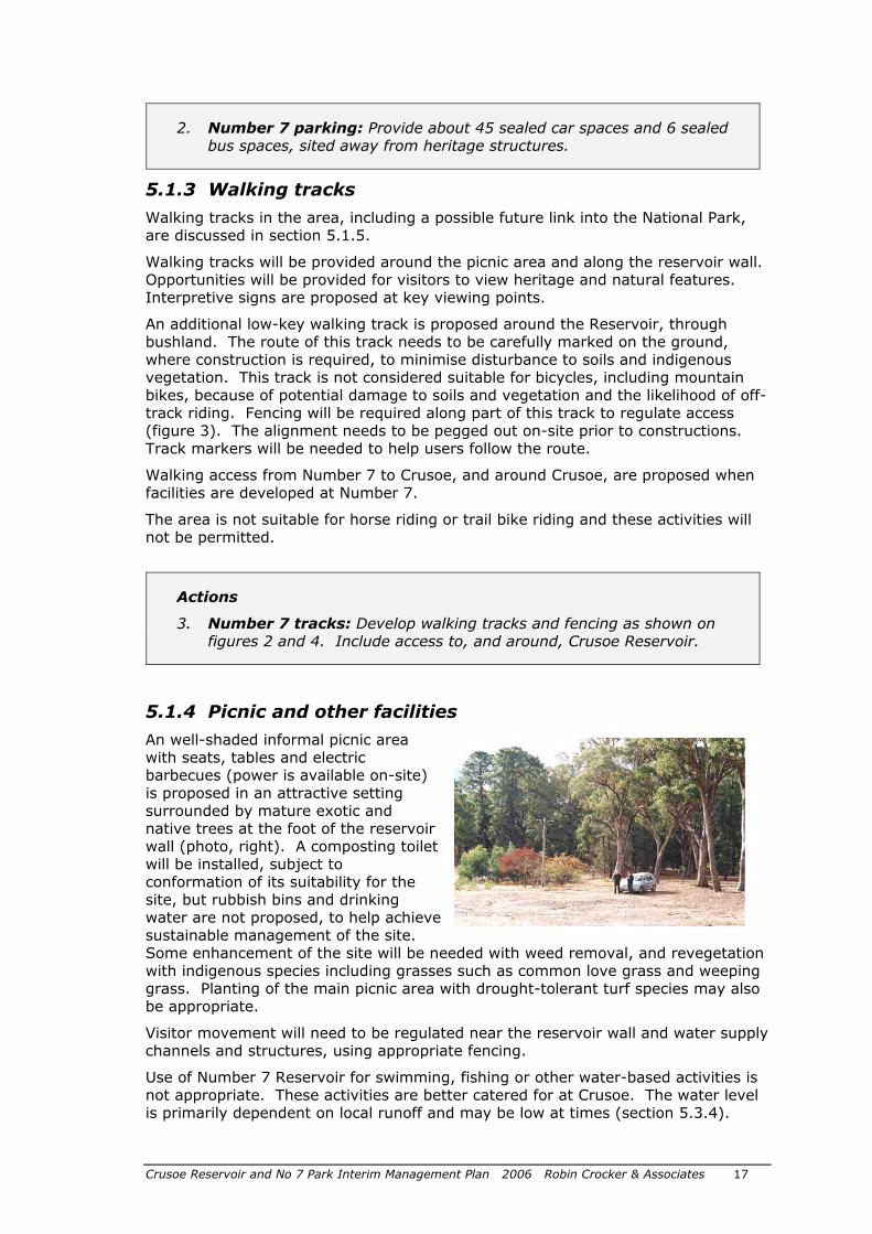
An well-shaded informal picnic area with seats, tables and electric barbecues (power is available on-site) is proposed in an attractive setting surrounded by mature exotic and native trees at the foot of the reservoir wall (photo, right). A composting toilet will be installed, subject to conformation of its suitability for the site, but rubbish bins and drinking water are not proposed, to help achieve sustainable management of the site. Some enhancement of the site will be needed with weed removal, and revegetation with indigenous species including grasses such as common love grass and weeping grass. Planting of the main picnic area with drought-tolerant turf species may also be appropriate.
Visitor movement will need to be regulated near the reservoir wall and water supply channels and structures, using appropriate fencing.
Use of Number 7 Reservoir for swimming, fishing or other water-based activities is not appropriate. These activities are better catered for at Crusoe. The water level is primarily dependent on local runoff and may be low at times (section 5.3.4).
Crusoe Reservoir and No 7 Park Interim Management Plan 2006 Robin Crocker & Associates 18
Compatible, small-scale community based functions or activities may be appropriate, in accordance with existing Council procedures.
Actions
4. Number 7 facilities: Provide an attractive low-key picnic area near the reservoir wall, with fencing used to regulate visitor access to areas with heritage values or where safety is an issue.
5. Number 7 activities: Permit compatible community-based activities in/near the picnic area but do not permit swimming or other recreation activities on Number 7 reservoir.
5.1.5 User safety and risk management
Safety is discussed in section 5.1.6. At Number 7, the main hazards relate to water supply structures, wild fire and old exotic trees. Fencing and signs will be needed to minimise risk. A Council risk assessment and proposed treatments is set out in appendix 3.
No fishing, boating and swimming signs will be needed in conjunction with enforcement. No fireplaces are to be provided and fire lighting prohibited.
Actions:
6. Number 7 risks: Implement risk management tasks including fencing and signs to restrict visitor access to hazardous areas, and signs banning fires, and recreation activities on the reservoir.
5.1.6 Regulations, dogs
The site will be reserved as a Committee of Management area under the Crown Lands Reserves Act (1978), and Crown Lands Reserves regulations will apply.
Dogs and other domestic pets are not appropriate in the area.
Actions
7. Number 7 regulations: Post regulations in the area and use symbol signs to advise visitors of key requirements. Do not permit dogs or other domestic pets.
5.1.7 Fees
Facilities provided at Number 7 will be of a moderate standard and no fees are proposed for regular use. Fees may be charged for small-scale organised activities at the site.
Crusoe Reservoir and No 7 Park Interim Management Plan 2006 Robin Crocker & Associates 19
5.2 Goal 2: Develop access and informal recreation facilities at Crusoe Reservoir
This interim plan provides for the development of initial access and basic recreation facilities at Crusoe which can be established in the short-term, independently of a decision regarding the appropriateness or design of a water play and swimming area. Details of the option to develop a beach are provided in appendix 4).
A further factor influencing future recreational use of Crusoe Reservoir is possible use of the reservoir as a flood mitigation site (suggested by North Central Catchment Management Authority). This would involve lowering the full supply water level by 0.7 to 1 m and operating the reservoir (above the lowered level) as a retarding basin. This would affect future recreational use and may affect the design of a water interface or swimming area. Further investigation of this option is required to assess advantages and disadvantages.
Actions
8. Flood retarding function: Review option of using Crusoe Reservoir as a flood retarding basin (with reduced full supply water level) and assess advantages and disadvantages including reduced recreation opportunities.
5.2.1 Vehicle entry and access
Primary access
The major access point to the Crusoe area will be from a point on Crusoe Road about 1 km west of the reservoir wall (figure 2). An engineering assessment and detailed design will be needed to ensure safe vehicle entry and exit. No access for public vehicles will be provided to the former works area off Crusoe Road below the reservoir wall.
Design components include:
• Direction signs to the park (from the Calder Highway and on Crusoe Road). • Appropriate turning lanes and a well graded and aligned entry road from
Crusoe Road. • An attractive entrance. • A CoGB name sign (‘Crusoe Reservoir’ with key rule symbols) – to conform
with Council’s Style Manual • Information on opening hours, facilities and key regulations. • A boom gate to regulate entry, and an exit lane with a mechanism allowing
exit only. • Appropriate fencing to prevent vehicles from leaving the entry road, and to
restrict trail bike and other access along the Specimen Hill Channel. • A small carpark near the entrance for walkers and cyclists using the park
after hours. • A gravel road, along the existing management track alignment, providing
visitor access to the reservoir area.
Park opening and closing times should be determined by Council in accordance with current policy for other venues. Closing times of about 5 PM in winter and 9 PM is summer may be appropriate.
Crusoe Reservoir and No 7 Park Interim Management Plan 2006 Robin Crocker & Associates 20
Emergency access
An emergency exit/management track is proposed, based on the existing track, from the south west corner of the reservoir to the north west end of the reservoir wall. Most other existing management tracks should also be maintained for ongoing management use. Coliban Water will require regular access to channels and other infrastructure for operational purposes.
Secondary access
A secondary access point is proposed near the spillway, at the north west end of the Crusoe reservoir wall. An existing access track off Crusoe Road would be used and a simple ramp provided to the water’s edge (for launching small sailing craft by hand). This access point would only be used by organised groups using the reservoir for sailing or similar activities, and for management or emergency access. Existing gates and fencing would be retained and signs installed and parking, etc defined.
The demand for sailing or similar use is unclear and development of this area should be deferred, except for emergency access, until a specific use is identified which meets with Council recreation objectives.
Actions
9. Crusoe public access: Provide a public entry point off Crusoe Road with a gravel access road (to the reservoir area), gates, fencing, signs, information and a small entrance carpark.
10. Crusoe restricted access: Provide a restricted access point near the north end of the reservoir wall for management purposes and for group water-based uses, when demand is demonstrated.
5.2.2 Parking
Small-scale gravel parking areas are proposed in the short-term, located in degraded areas where indigenous vegetation has been removed, near the south west corner of the reservoir. About 30 spaces will be provided.
Careful design of drainage from parking areas and roads (including sediment and litter traps etc) will be essential to minimise flow of sediment, plant debris and pollutants into the reservoir. Use of best practice water sensitive urban design incorporating swales and bio retention facilities should be included.
A second minor carpark is proposed (in the long-term) near the spillway at the north end of the reservoir wall for group water-based activities. This would have 20-30 spaces and be located largely on existing surfaced areas.
Parking areas and associated roads will need to be fenced to contain vehicles and deter visitors from walking into bushland areas.
Actions
11. Reservoir parking: Develop gravel parking areas to cater for visitors to the reservoir and surrounding bushland, designed to minimise disturbance to indigenous vegetation and impacts on water quality in the reservoir.
12. Spillway parking: Define parking areas (with regulated access) at north end of reservoir wall if/when area developed.
Crusoe Reservoir and No 7 Park Interim Management Plan 2006 Robin Crocker & Associates 21
5.2.3 Swimming area and water access
As indicated in section 1.4, the construction of a beach or other water interface at Crusoe Reservoir requires more detailed investigations before Council can make a clear decision.
Additional information will help refine the proposal for a beach set out in the initial management plan. The main components of the proposal are included in appendix 4 of this plan.
Important issues to be further investigated include:
• Water level: will inflow from the local catchment (or water purchased from Coliban Water) maintain water at an adequate level for water-based recreation?
• Flood mitigation: should Crusoe have a role in flood mitigation for the upper catchment of Bendigo Creek (section 5.1)?
• Water quality: will ongoing quality meet health requirements?
• Cost: will the construction of a beach and associated facilities provide an adequate cost benefit?
• Environmental impacts: will a beach and associated facilities have unacceptable impacts?
Specific investigations have been proposed as follows.
• Review of 1999 Sinclair Knight Mertz report on water flows, incorporating climate change projections and review of the potential for Crusoe Reservoir to provide for flood mitigation
• A water quality management plan
• A cost benefit analysis
• An environment impact assessment
Following completion of these studies, Council can consider the future provision of a water interface of some form (eg a beach, boardwalk and viewing deck), and the development of associated facilities (parking, toilets, etc).
Water level and catchment run-off issues
Maintaining an adequate water level in the reservoir will be important to maximise use of any water interface, swimming or boating facilities. The water level in Crusoe was reduced in about 2003 to allow works to be undertaken on the reservoir wall. The level rose to 282 m by March 2005.
The full supply level at Crusoe is now 284.5 m (previously 286.6 m). Evaporation is about 1 m/year.
A recent engineering review (SKM 1999) found that with average rainfall this local flow should maintain the reservoir at an adequate level more than 80% of the time. However, this review may have overestimated the current catchment areas for Crusoe and Number 7 reservoirs. Run-off issues are discussed further in section 5.3.4.
In dry years, some additional water is expected to be available from the Malmsbury Reservoir via Coliban Water’s Main Channel, at the going price. If below average rainfall continues, some additional water may be needed to maintain an adequate water level.
Water level (and water quality) could affect the growth of aquatic plants in the reservoir. Plant growth, due particularly to nutrient inflow, has been a problem in several water bodies including Lilydale Lake, Albert Park Lake, the Royal Botanic

Crusoe Reservoir and No 7 Park Interim Management Plan 2006 Robin Crocker & Associates 22
Gardens and Lake Weeroona. Any changes in aquatic plant growth should be monitored.
Crusoe Reservoir and No 7 Park Interim Management Plan 2006 Robin Crocker & Associates 23
Water quality issues
Maintaining good water quality at Crusoe Reservoir is critical for water-based recreation. Crusoe has until recently provided potable water for Bendigo and water quality is expected to remain high after the site is open to the public provided sound management principles are followed. Tests by Coliban Water up to 2002 showed that E coli levels were mostly well below the accepted standard of <150 organisms/100 ml (Fyffe pers. comm.)
A water quality monitoring plan is needed in accordance with relevant environmental legislation and include nutrient levels, pathogens and blue-green algae. This should be integrated with a monitoring program developed by Council for five other urban lakes. Current baseline data should be obtained as part of the program.
A major NHMRC guideline on recreational water use – 2nd edition of Guidelines for Managing Risks in Recreational Water (at www.nhmrc.gov.au) - is due for release in August 2006. This will provide valuable guidance for Council in managing the site.
Actions in this management plan draw on the advice and experience of experts from a range of organisations but additional review is recommended to ensure ‘best practice’ management of water quality.
Actions
13. Investigations: Commission separate investigations of: - water flows’ - water quality management’ - cost benefits’, and - environment impacts, to assist in determining the best form of water access and interface.
5.2.4 Short-term facilities and activities
The following facilities and activities are proposed to allow use and enjoyment of the Crusoe area in the short-term. More extensive facilities may be provided in the medium to long-term when a decision has been made on the possible provision of a beach and water access.
Walking and cycling
Extensive walking and cycling opportunities will be provided including a link between Crusoe Reservoir and Number 7 Park (section 5.1.5).
Picnicking
Tables and seats will be provided near the south west corner of the reservoir, located beside walking tracks and at selected viewing points. Composting toilets are proposed at Crusoe Reservoir in the short-term. No refreshment vans will be permitted in the short-term.
Facilities are to meet disability standards (SRV 2001).
Swimming and boating
Swimming, boating and similar water-based activities will not be permitted in the short-term. Possible future opportunities are discussed in appendix 4.
Crusoe Reservoir and No 7 Park Interim Management Plan 2006 Robin Crocker & Associates 24
Fishing / fly casting
A basic survey by DSE in about 2000 found some Red Fin and Tetch in the Reservoir. It was subsequently stocked by DSE with about 5000 native Golden Perch fingerlings released annually over three years (McCrae, pers. comm.).
Fishing is proposed, broadly in accordance with the regional fishing plan (NRE 2002). Shoreline fishing should only be permitted in a designated area to minimise any impacts on other users and water quality. A section of the reservoir, near the reservoir wall, is proposed. Only lures or natural baits are to be used and no fish cleaning will be permitted in the reserve. Adequate staff supervision of fishing (and other water-based activities) will be important. Fish stocking by DSE must continue to be compatible with water quality objectives.
Fly-casting will be permitted away from the main visitor area.
Astronomical activities
Open areas at Crusoe or Number 7 Park appear to be a suitable for use as a ‘dark sky’ site – providing for community star nights and astro-photography. Views of the sky down to 15 degrees above the horizon would be required, and access to parking and toilets. Natural and cultural values would need to be protected, and after-hours access arranged. Discussions with the Bendigo District Astronomical Society would assist in assessing the feasibility of the proposal.
Other events and activities
Events
Crusoe reservoir will be developed for informal recreation and conservation of natural and cultural values. The site will not be suitable for large-scale events but may cater for small-scale events which have minimal impact on environmental values.
Prospecting
Prospecting in the area could adversely affect water quality and will not be permitted in the areas around Crusoe and Number 7 reservoirs.
Construction
Native Title needs to be considered (in consultation with DSE) prior to undertaking any construction activities.
Works also need to be undertaken with appropriate monitoring by representatives of Aboriginal communities (Nelson and Kerr pers comm.)
Site clean up
Rubbish left in various parts of the reserve needs to be removed and hazards dealt with.
At the old house site north of Crusoe Reservoir, the well should be fenced or carefully filled with soil, and the area cleared of loose rubbish. Wormwood and other invasive exotic species should be removed and the area planted with indigenous shrubs.
Redundant Coliban Water structures near the north end of the Crusoe reservoir wall should eventually be removed, but may be useful for park management purposes in the short to medium term. Dead and dying pines in this area also need to be removed.
Crusoe Reservoir and No 7 Park Interim Management Plan 2006 Robin Crocker & Associates 25
Actions
14. General recreation activities: Provide basic facilities, including paths, tables and seats, compatible with the management principles for Crusoe Reservoir. Monitor the success and impacts of recreation activities and encourage future uses which do not adversely affect water quality and are compatible with the site.
15. Fishing: Monitor fishing impacts and liaise with DSE regarding fish stocking to ensure water quality is not adversely affected.
16. Astronomy: Review with the Bendigo District Astronomical Society the feasibility of using Crusoe Reservoir or Number Park 7 as a ‘dark sky’ site.
17. Maintenance program: Develop a program for ongoing maintenance and management of visitor areas.
5.2.5 Walking, bicycle and other tracks
Walking and cycling are popular around Bendigo and the study area provides opportunities to provide for these activities in a bush setting. Some of the existing management tracks are suitable for walking and cycling and there are also opportunities to develop some informal walking tracks.
Proposed tracks are shown on figures 2 and3. Loops would be provided around both reservoirs and an existing management track used to link the two main visitor areas.
Three main grades of track are proposed:
• 3 to 4 m wide gravel management/walking/cycling tracks.
• 2.4 m wide gravel shared paths (walking/cycling)
• 1.2 to 1.5 m wide gravel/earth walking tracks
In low-use areas, ie around Number 7 Reservoir, the proposed walking track will require minimal construction and may be identified by removing debris and marking the route with a thin layer of gravel and track markers.
Fencing will be needed to deter people from leaving tracks and heading across country.
Some visitors will choose to walk around Crusoe Reservoir above the water line. This is unlikely to affect environmental values and should be permitted, unless unacceptable damage occurs.
Tracks will not be provided in other parts of the planning area because of the difficulty in preventing off-track walking which could adversely affect water quality, damage soils and vegetation and put visitors at risk from water channels, mining hazards and lack of orienting features. The risk of fire starting would also be increased.
Horses and trail bikes
The area is not suitable for horse riding or trail bike riding and these activities will not be permitted on or off tracks. Prospecting will also not be permitted (section 5.1.4).
Links to and from the reserve
A connection should be investigated to the Bendigo Bushland trail which runs along Furness Street and Carcoola Drive near the reservoir wall. This would entail access along Crusoe Road.
Crusoe Reservoir and No 7 Park Interim Management Plan 2006 Robin Crocker & Associates 26
Bicycle access to Number 7 Reservoir is proposed from Furness Street along Granter Street.
Walking track links to the adjacent national park may be provided in the future, with the agreement of Parks Victoria. A suitable access point has been identified, south of the reservoir wall at Number 7 Park (figure 3)
Actions
18. Walking and cycling: Develop walking and cycling tracks as shown in figures 2 and 3. Do not permit horse or trail bike riding in the area.
5.2.6 User safety, water quality and risk management
The safety of visitors and staff is a very high priority. Possible risks identified include water-based activities, open water channels, falling limbs, uneven ground, falls, disorientation, sunburn, fire and public disturbance. Declining water quality is also a potential risk. A Council risk assessment and proposed treatments is set out in appendix 3. Water quality is discussed in section 5.1.3.
Fire and other emergencies
Emergency planning is a key requirement for the area.
The most likely wildfire threat is from the north or north-west, providing a potential threat to visitors to Crusoe reservoir. DSE and the CFA have indicated that the main fire risk is likely to involve people lighting fires in visitor areas. A ban on all fires in the area and limiting public access into bushland areas is a logical planning response. A visible staff presence is highly desirable particularly on busy and hot days.
A management/walking track linking the Crusoe visitor area with the Reservoir wall area is proposed as an emergency access track for public vehicles in the case of fire or other emergencies. A temporary barrier or management gate would be used at each end of the track to prevent casual use. Track clearance 4 m wide and 4 m high is desirable for CFA tankers and access to the reservoir is desirable (Gilmour and Neander pers. comm.)
A cleared area west of Crusoe Reservoir and the entrance road would be a suitable site for helicopter landing.
The area must have a current fire and emergency plan including evacuation procedures. The park may be closed on days of total fire ban, at the discretion of the site manager. The site will be reserved for Public Purposes and the CFA will be responsible for fire fighting.
Key components of an emergency plan include:
o Designation within Council of responsibility for overseeing safety and emergency procedures at Crusoe Reservoir and Number 7 Park.
o Documented procedures for dealing with emergency situations including fire, injury, incidents and accidents, and blue-green algae outbreaks. Procedures are to include methods of informing users of emergency situations, actions to take and exit routes.
o Documentation for staff of responsibilities and contact details for emergency services - and ongoing liaison with: Victoria Police, the Ambulance Service, the CFA, Coliban Water, Parks Victoria, DSE and the EPA. Gate keys and access maps are also to be provided as appropriate.
o Provision of appropriate staffing/patrols to respond to emergency situations.
o Provision of emergency and exit information on information panels/shelters at Crusoe and Number 7.
o Clear designation of exit routes.
Crusoe Reservoir and No 7 Park Interim Management Plan 2006 Robin Crocker & Associates 27
o Clear designation that no fires are permitted.
o Monitoring of fire danger and other threats and closing of the parks when appropriate.
o Ongoing maintenance of vehicle tracks to meet emergency vehicle requirements.
o An incident reporting system to provide for documentation of all defined incidents.
Trees
An expert assessment of dangerous trees and limbs should be undertaken and remedial work commissioned. The area of old pines at the west end of the reservoir should be included in the assessment.
Other risks
Several old mining excavations south of Crusoe Reservoir have a sheer drop and are a potential hazard.
Feeding wildlife, especially kangaroos, can lead to attacks on visitors and will be discouraged.
Actions
19. Risk assessments: Complete risk assessments and ensure compliance with Council risk management requirements including regular inspection of facilities and trees and timely action to deal with identified hazards.
20. Emergency plan: Maintain a Crusoe Reservoir and Number 7 Park Emergency Management Plan.
21. Mining hazards: Back-fill or fence old mining holes south of Crusoe Reservoir.
5.2.7 Regulations, dogs
Following site survey and redesignation of the site for public use, the area will be reserved as a Committee of Management area under the Crown Lands (Reserves) Act (1978). Crown land reserves regulations could then apply, and Council regulations. These regulations need to reflect the management principles and directions described in this plan.
Dogs and other domestic pets are not appropriate in bushland areas because of health risks and other impacts on visitors and natural values. There are many alternative opportunities for dog walking around Bendigo.
Actions
22. Regulations and dogs: Develop appropriate regulations for the area, post in public areas, and use symbol signs to advise visitors of key requirements. Do not permit dogs or other domestic pets in the reserve.
5.2.8 Fees
No fees are proposed unless extensive recreation facilities are developed.
Crusoe Reservoir and No 7 Park Interim Management Plan 2006 Robin Crocker & Associates 28
5.3 Goal 3: Maintain and protect natural and cultural values
The protection of natural values is a key requirement of the proposal to develop visitor facilities in the study area. This section provides an overview of future management activities. More detailed annual programs, eg for weed control and pest animal control, will need to be developed following approval of the management plan.
5.3.1 Vegetation
A survey of vegetation quality was undertaken during the project to assist in determining management actions. Further assessments are desirable to increase knowledge and understanding of ecological values and threats.
The area supports significant stands of indigenous vegetation although weed infestations occur in some disturbed areas. A plant list is provided in appendix 5.
Ecological Vegetation Communities (EVC’s)
Three Ecological Vegetation Communities are present around Crusoe Reservoir and correspond closely to the land units described above (figure 4).
Heathy Dry Forest – EVC 20 Goldfields Bioregion This EVC occurs upslope of Box Ironbark Forest – Northern Goldfields and the boundary between the two is roughly defined by the 300m contour. Eucalyptus tricarpa - Red Ironbark, Eucalyptus macrorhyncha - Red Stringy Bark and Eucalyptus polyanthemos subsp. vestita - Red Box form the tree canopy. Common understorey species are Brachyloma daphnoides – Daphne Heath and Joycea pallida - Red Anther Wallaby Grass.
Box Ironbark Northern Goldfields EVC 61 This EVC is widespread throughout the Goldfields Bioregion. Eucalyptus tricarpa - Red Ironbark and E. microcarpa - Grey Box are the dominant trees of this EVC and occasionally E. leucoxylon - Yellow Gum, E. polyanthemos subsp. vestita - Red Box or E goniocalyx - Long-leaf Box are also present. There is an open shrubby understorey, almost always including Acacia pycnantha - Golden Wattle, Ac. acinacea -Gold-dust Wattle, Ac. genistifolia -Spreading Wattle, Pultenaea largiflorens -Twiggy Bush-pea, Cassinia arcuata - Drooping Cassinia and Xerochrysum viscosum - Shiny Everlasting. The ground layer is very sparse, the most consistent species being Lomandra filiformis - Wattle Mat Rush, Dianella admixta - Flax Lily, Austrodanthonia setacea - Bristly Wallaby Grass, Astroloma humifusum - Cranberry Heath, Hibbertia exutiacies - Tangled Guinea Flower and Gonocarpus tetragynus - Common Raspwort, Briza maxima – Shell Grass is a common weed.
Alluvial Terraces Herb-rich Woodland. EVC 67 Goldfields Bioregion This EVC is highly modified by historic alluvial mining activities occurring up the drainage lines entering Crusoe and Number 7 Reservoirs, and obviously by the reservoirs themselves.
The tree canopy consists of Eucalyptus melliodora - Yellow Box and Eucalyptus microcarpa - Grey Box. These trees have regenerated since the alluvial mining days of the 1920 and 1930s. The disturbed ground layer has remnants of the common species found in this EVC such as Tricoryne elatior - Yellow Rush Lily, Solenogyne dominii – Solenogyne, Microseris lanceolata - Yam Daisy, Arthropodium strictum - Chocolate Lily and Acaena echinata – Sheep’s Burr.
Vegetation Significance
Crusoe Reservoir and No 7 Park Interim Management Plan 2006 Robin Crocker & Associates 29
Box-Ironbark Forest has a conservation status of ‘Depleted’ within the Goldfields bioregion (DSE, 2003). Approximately 85% of the original extent of the Box-Ironbark Forest has been cleared since European settlement, and that which remains has been highly modified by timber harvesting, farming, urbanisation and mining, therefore preservation of the remaining forest is vital for biodiversity conservation.
Assessment of quality of vegetation in EVCs
Heathy Dry Forest – EVC 20 The pockets of Heathy Dry Forest in the study area are in good condition, due in part to their more highly elevated position, and inclusion in State Forest and Water Catchment Reserve. The water race typically forms its upper boundary.
Box Ironbark Forest - Northern Goldfields EVC 61 This is the most common EVC within the study area. It is found approximately between the 300m and 290m contour. The quality of the vegetation in this EVC can be divided into three sections:
1 West of the fence, road and drainage line running north-south: significantly disturbed. Possibly this area was part of the original property and grazed.
2 East of Section1, towards the proposed main carpark: this was mined for alluvial gold and there are excavations and erosion degrading the quality of vegetation.
3 East of the planned main carpark, the vegetation quality improves significantly. One section (see plan) is of very high quality, supporting mature Ironbark and Grey Box. This area must be protected from impacts.
Alluvial Terraces - Herb-rich Woodland. EVC 67 This EVC is highly modified by historic mining and resultant erosion and by proximity to the reservoir.
Weeds
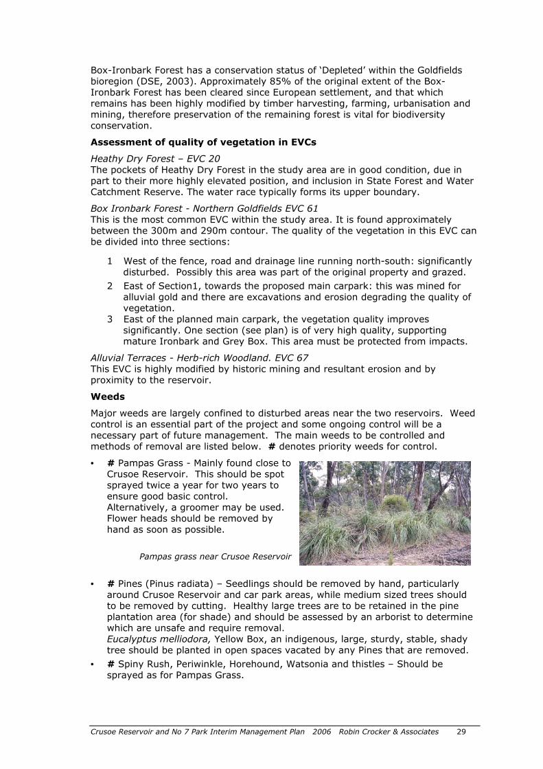
Major weeds are largely confined to disturbed areas near the two reservoirs. Weed control is an essential part of the project and some ongoing control will be a necessary part of future management. The main weeds to be controlled and methods of removal are listed below. # denotes priority weeds for control.
• # Pampas Grass - Mainly found close to Crusoe Reservoir. This should be spot sprayed twice a year for two years to ensure good basic control. Alternatively, a groomer may be used. Flower heads should be removed by hand as soon as possible.
Pampas grass near Crusoe Reservoir
• # Pines (Pinus radiata) – Seedlings should be removed by hand, particularly around Crusoe Reservoir and car park areas, while medium sized trees should to be removed by cutting. Healthy large trees are to be retained in the pine plantation area (for shade) and should be assessed by an arborist to determine which are unsafe and require removal. Eucalyptus melliodora, Yellow Box, an indigenous, large, sturdy, stable, shady tree should be planted in open spaces vacated by any Pines that are removed.
• # Spiny Rush, Periwinkle, Horehound, Watsonia and thistles – Should be sprayed as for Pampas Grass.
Crusoe Reservoir and No 7 Park Interim Management Plan 2006 Robin Crocker & Associates 30
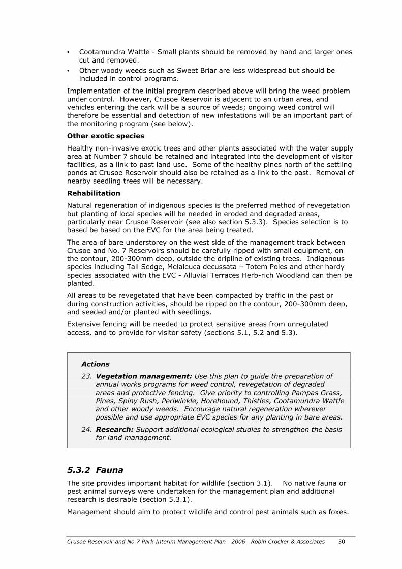
• Cootamundra Wattle - Small plants should be removed by hand and larger ones cut and removed.
• Other woody weeds such as Sweet Briar are less widespread but should be included in control programs.
Implementation of the initial program described above will bring the weed problem under control. However, Crusoe Reservoir is adjacent to an urban area, and vehicles entering the cark will be a source of weeds; ongoing weed control will therefore be essential and detection of new infestations will be an important part of the monitoring program (see below).
Other exotic species
Healthy non-invasive exotic trees and other plants associated with the water supply area at Number 7 should be retained and integrated into the development of visitor facilities, as a link to past land use. Some of the healthy pines north of the settling ponds at Crusoe Reservoir should also be retained as a link to the past. Removal of nearby seedling trees will be necessary.
Rehabilitation
Natural regeneration of indigenous species is the preferred method of revegetation but planting of local species will be needed in eroded and degraded areas, particularly near Crusoe Reservoir (see also section 5.3.3). Species selection is to based be based on the EVC for the area being treated.
The area of bare understorey on the west side of the management track between Crusoe and No. 7 Reservoirs should be carefully ripped with small equipment, on the contour, 200-300mm deep, outside the dripline of existing trees. Indigenous species including Tall Sedge, Melaleuca decussata – Totem Poles and other hardy species associated with the EVC - Alluvial Terraces Herb-rich Woodland can then be planted.
All areas to be revegetated that have been compacted by traffic in the past or during construction activities, should be ripped on the contour, 200-300mm deep, and seeded and/or planted with seedlings.
Extensive fencing will be needed to protect sensitive areas from unregulated access, and to provide for visitor safety (sections 5.1, 5.2 and 5.3).
Actions
23. Vegetation management: Use this plan to guide the preparation of annual works programs for weed control, revegetation of degraded areas and protective fencing. Give priority to controlling Pampas Grass, Pines, Spiny Rush, Periwinkle, Horehound, Thistles, Cootamundra Wattle and other woody weeds. Encourage natural regeneration wherever possible and use appropriate EVC species for any planting in bare areas.
24. Research: Support additional ecological studies to strengthen the basis for land management.
5.3.2 Fauna
The site provides important habitat for wildlife (section 3.1). No native fauna or pest animal surveys were undertaken for the management plan and additional research is desirable (section 5.3.1).
Management should aim to protect wildlife and control pest animals such as foxes.
Crusoe Reservoir and No 7 Park Interim Management Plan 2006 Robin Crocker & Associates 31
An opportunity has been identified to release the Vulnerable native Freshwater catfish into Number 7 Reservoir. The species has declined markedly in Victoria and the reservoir could become a valuable site. The catfish has very unusual nesting behaviour, readily visible from the shoreline, providing good opportunities for interpretation. Further discussion of management requirements and assistance should be undertaken with DSE.
Actions
25. Pest animals: Manage the area to protect wildlife and control major pests, in conjunction with adjoining land managers.
26. Native fish: Liaise with DSE and determine the practicality of introducing native Freshwater catfish into Number 7 Reservoir.
5.3.3 Fire
Fire is an important issue in protecting natural values in the area.
The initial impact of a bushfire through the area would be increased erosion, the extent obviously depending on the intensity of the fire and the subsequent rainfall pattern. This would increase sediment flow into the reservoir and probably also deposit sediment over other recreational areas. Recovery of vegetation would equally depend on the fire intensity and the weather, but would also be affected by the inability of species to regenerate down slope of the Specimen Hill Channel and catch drains.
Originally, vegetation on the slope (Box Ironbark Forest) received surface run off from the extensive area uphill and developed in response to these conditions. But the construction of the water race and the change to drainage patterns have meant that some areas now receive only direct rainfall and the breaching of the catch drains has not substantially changed the situation. This makes the vegetation very vulnerable to disturbance either by fire or human impact. Without the normal overland flow of water, these pockets of vegetation are likely to be unable to regenerate successfully after serious disturbance.
In this context an ecological burn would also be harmful.
Actions
27. Ecological burning: Do not undertake ecological burns in the area and give high priority to fire prevention and suppression.
5.3.4 Geology, soils, erosion and run-off
Land units
The whole area is underlain at shallow depth by sedimentary rocks of Ordovician age and three land units can be recognised, the boundaries between them essentially following the contours.
Rocky Ridge This is the typical “Stringybark Ridge” and lies above the 300 m contour forming a narrow margin to the project area. It corresponds approximately to the Ose (Ordovician sediments, gentle crest) land unit of Bluml et al. (1995). Soils are thin,
Crusoe Reservoir and No 7 Park Interim Management Plan 2006 Robin Crocker & Associates 32
stony yellow duplex, with significant areas of exposed rock. Natural vegetation is Grey Box and Red Stringybark (Heathy Dry Forest EVC).
Gentle Slope This unit lies largely between the 290 m and 300 m contours; it corresponds approximately to the OSF (Ordovician sediments – gentle slope) of Bluml et al. (1995). The soil profile is deeper than on the rocky ridge, consisting of sandy loam topsoil overlying clay subsoil. It is poorly drained, because of the heavy soil. Natural vegetation is Ironbark, with some Yellow Gum and Grey Box (Box Ironbark – EVC).
Alluvial Terrace This land unit forms a narrow fringe around the shore and the small valley on the southern side; it corresponds approximately to the Qa2 (Quaternary alluvium - floodplain) of Bluml et al. (1995). Although originating as alluvium, this material has probably been affected to some degree by the water in the reservoir and it has also been extensively reworked by alluvial mining.
The soil profile is deeper than on the rocky ridge, consisting of sandy clay loam. It is poorly drained, because of the heavy soil. Natural vegetation is Yellow Box, with some Grey Box (Alluvial Terrace EVC).
Run-off, sediment and erosion
Crusoe Reservoir originally operated successfully utilising inflow from its local catchment, prior to the construction of the Specimen Hill Channel. Subsequently, Crusoe was filled from Malmsbury Reservoir and catch drains were constructed to intercept local run-off and divert it away from Crusoe. Coliban Water has recently altered some catch drains to re-direct local runoff into the reservoir again, however part of the original local catchment no longer flows into Crusoe - runoff from some of the area to the south and west of the Specimen Hill Channel flows into the Channel or is still diverted away from Crusoe. The Channel forms the boundary between the planning area and the National Park (figure 2)
Vegetation has been adversely affected in some parts of the study area where run-off has been reduced due to construction of the Specimen Hill Channel and catch drains which intercept and divert overland flows along five drainage lines after rain.
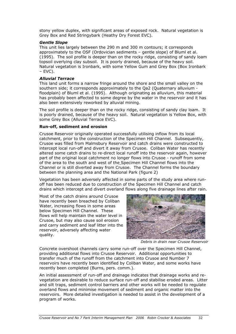
Most of the catch drains around Crusoe have recently been breached by Coliban Water, increasing flows in some areas below Specimen Hill Channel. These flows will help maintain the water level in Crusoe, but may also cause soil erosion and carry sediment and leaf litter into the reservoir, adversely affecting water quality.
Debris in drain near Crusoe Reservoir
Concrete overshoot channels carry some run-off over the Specimen Hill Channel, providing additional flows into Crusoe Reservoir. Additional opportunities to transfer much of the runoff from the catchment into Crusoe and Number 7 reservoirs have recently been identified by Coliban Water, and some works have recently been completed (Burns, pers. comm.).
An initial assessment of run-off and drainage indicates that drainage works and re-vegetation are desirable to reduce surface run-off and stabilise eroded areas. Litter and silt traps, sediment control barriers and other works will be needed to regulate overland flows and minimise movement of sediment and organic matter into the reservoirs. More detailed investigation is needed to assist in the development of a program of works.
Crusoe Reservoir and No 7 Park Interim Management Plan 2006 Robin Crocker & Associates 33
On drainage lines entering the reservoir, webbed jute-matting should be pegged onto bare susceptible areas and planted with cells of Carex appressa – Tall Sedge which is an indigenous sedge adapted to the harsh conditions of these ephemeral water courses.
An area at the intersection of two drainage lines between Crusoe Reservoir and Number 7 Reservoir was formerly badly infested by spiny rush. This has been eliminated by residual herbicide application, and the ground is now bare apart from the trees. Although this area will not be contributing sediment/runoff to the reservoir it does require rehabilitation.
Construction Activities
Areas to be disturbed by construction activities should wherever practicable have vegetation rescued and/or seed collected and used in revegetation.
Trail bike damage
Damage to soils (and vegetation) has resulted from recent trail bike riding in the area. It is essential that trail bikes are excluded through fencing, education and enforcement.
Actions
28. Run-off and inflows: Undertake further investigations of run-off and drainage, and, in liaison with Coliban Water and Parks Victoria, design and implement a program of works to maximise flows of high quality water into the reservoirs.
29. Erosion: Fence out eroded and damaged areas, where appropriate, and progressively rehabilitate using matting and replanting with local species.
30. Trail bikes: Maintain fences around the area and undertake education and enforcement programs to minimise damage caused by trail bikes.
5.3.5 Cultural values
Little information is available on possible Aboriginal sites in the study area. Ongoing liaison with the local Jaara Jaara community is important, and an assessment will be required regarding Native Title. The traditional ownership of the land by the Jaara Jaara people should be recognised.
Any future works in these areas, particularly near Crusoe Reservoir, will require a ‘future act assessment’ prior to works commencing. Consultation should occur for all future surveys and excavations, with appropriate monitoring of earthworks.
The water supply structures are of statewide significance and are listed on the Victorian Heritage Register. These must be managed in accordance with Heritage Victoria requirements. The structures at both Crusoe and Number 7 are largely intact and provide excellent opportunities for interpretation.
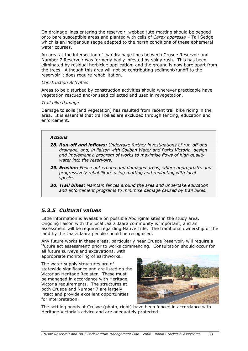
The settling ponds at Crusoe (photo, right) have been fenced in accordance with Heritage Victoria’s advice and are adequately protected.
Crusoe Reservoir and No 7 Park Interim Management Plan 2006 Robin Crocker & Associates 34
A survey was undertaken at Number 7 Reservoir in conjunction with this management plan to help ensure compliance with Heritage Victoria requirements and assist with the planning of visitor access and use, and site interpretation (Kaufman 2005).
The survey noted a number of important features, particularly the reservoir, settling ponds, underground water cistern, water channels and gates, a round brick storage tank, a chlorinator site and magazines. The remains of a residence and garden were also documented. Trees of interest below the reservoir wall include pines (Pinus radiata), a Monterey Cypress, poplars, a maple and remnants of an orchard including crab-apple trees and a plum.
Kaufman recommended construction of fences and gates to minimise risks to visitors and structures, provision of interpretation of heritage features and retention of orchard trees. He also recommended minor realignments of parking areas, fences and tracks proposed in the 2004 master plan. These are incorporated in figure 3.
Additional management /maintenance works were also suggested including:
o Settling ponds: shallow excavation to expose the top of the surrounding brick walls, and weed control
o Brick in-ground tank: remedial work on brickwork, and ongoing weed control
o Timber fencing etc: repair/repainting in existing colours
Any works on the actual fabric will require Permits under the Heritage Act 1995.
Actions
31. Aboriginal sites: Liaise with the local Jaara Jaara community and arrange for appropriate on-site monitoring during construction works. Ensure protection of any sites and seek a ‘future act assessment’ through DSE regarding Native Title for proposed developments.
32. Heritage approvals: Obtain approval from Heritage Victoria for works proposed at Number 7 in the area covered by the Heritage Register listing for the site.
33. Heritage protection: Protect heritage features in accordance with Kaufman’s Cultural Heritage & Interpretation Statement (2005).
Crusoe Reservoir and No 7 Park Interim Management Plan 2006 Robin Crocker & Associates 35
5.4 Goal 4: Provide effective and sustainable management, compatible with Bendigo Regional Park and Greater Bendigo National Park
5.4.1 Management responsibility
The Bendigo Regional Park is reserved under the Crown Land (Reserves) Act 1978. Clear management responsibility for the Crusoe and Number 7 areas and surrounding land in the Park is essential.
The City of Greater Bendigo is the proposed Committee of Management for the area around the two reservoirs. DSE will need to arrange the revocation of Permanent reserve status and reservation of the area for Public Purposes as part of the appointment process (anticipated to occur mid 2006). Parks Victoria will remain responsible for the remainder of the Park (figure 1). Parks Victoria also manages the adjacent Greater Bendigo National Park (located south of the Specimen Hill Channel).
Regular liaison between staff of Council and Parks Victoria is essential to ensure cooperative management of the area to deal effectively with issues such as public access, trail bikes, weeds and fire protection.
Coliban Water will retain responsibility for water supply structures which are still operational, eg the Main Channel and Specimen Hill Channel, including easements along specific channels and pipelines (ECC 2001, pp 156-7). Tasks such as weed control and track maintenance along channels needs to be agreed between Coliban Water, Parks Victoria (as adjoining land manager) and Council as Committee of Management. Management associated with redundant structures, eg controlling vegetation on reservoir walls, will become a responsibility of Council.
Responsibility for maintaining hydraulic structures such as reservoir walls in accordance with National Guidelines also needs to be clarified. There would be logic in assessing all dams/reservoirs managed by Council at the same time.
A 2003 Memorandum of Understanding between Council, Coliban Water, DSE and Parks Victoria (being updated in 2005) sets out the basis for future management. Coliban Water also has a maintenance manual detailing requirements (‘Coliban Water Operational and Maintenance for Crusoe and Number 7 Reservoirs, May 2005’). This is expected to be suitable for adoption by Council, with minor adjustments.
Actions
34. Management responsibility: Formalise management arrangements for the area including revocation of Permanent reserve status, reservation of area for Public Purposes, appointment of Council as Committee of Management, and agreement with Coliban Water regarding management of water supply structures and easements.
35. Cooperative management: Arrange regular meetings between Council and Parks Victoria staff to ensure integrated management of the area, possibly in conjunction with other open space.
36. Maintenance schedules: Review, develop and implement ongoing maintenance and inspection programs for infrastructure formerly managed by Coliban Water.
Crusoe Reservoir and No 7 Park Interim Management Plan 2006 Robin Crocker & Associates 36
5.4.2 Sustainable management
Sustainable management principles should be applied to facilities and services in the study area. These include conserving water, energy and non-renewable resources, recycling, providing effective waste treatment, having no adverse impact on ecological processes and maintaining compatible recreational and educational opportunities.
Management of the area should complement management of the adjacent regional and national parks to help ensure long-term sustainability of both areas.
The development provides Council with an opportunity to educate the community about sustainable practices and encourage low-impact behaviour. Initiatives will include a ‘no bins’ policy, to encourage visitors to take home and recycle rubbish. Use of sustainably harvested timber and recycled products are also proposed. Signs and bollards are to be of compatible colour, eg charcoal, and simple design and of square or rectangular section, eg ‘Knox’ bollard. Toilets will have waterless urinals and air hand driers where power is available.
Bicycle and walking access to the parks should also be promoted.
Actions
37. Sustainability: Plan for and ensure ongoing sustainable management practices, including a ‘no bins’ policy, use of sustainably harvested timber and recycled materials, and promoting pedestrian and bicycle access.
Crusoe Reservoir and No 7 Park Interim Management Plan 2006 Robin Crocker & Associates 37
5.5 Goal 5: Promote community involvement, appreciation and use
5.5.1 Community involvement in the area
‘Friends of’ and similar community groups have made a major contribution to the management, interpretation and monitoring of many natural and cultural sites across Victoria. The Crusoe and Number 7 areas provide excellent opportunities for community members to become involved in the protection and appreciation of natural and cultural heritage of the area. There will also be opportunities for groups interested in nature-based activities, and walking.
Council should promote and support a ‘Friends of Crusoe Reservoir’ and other groups and encourage ongoing community participation in the area.
Actions
38. Community involvement: Support community involvement in management, interpretation and monitoring of the area, eg through a Friends group.
5.5.2 Promotion
There will be numerous opportunities to promote use and appreciation of the Crusoe and Number 7 areas, eg in Council publications and web site, local media and tourist outlets. It will be important to promote the natural and cultural heritage of the area and opportunities for informal recreation and quite relaxation.
Actions
39. Promotion: Incorporate promotion of Crusoe Reservoir and Number 7 Park in existing media and encourage appropriate use and appreciation of the area.
5.5.3 Information
Information on the new areas (and adjacent parks) should be provided by Council and through other information outlets.
Information on recreational opportunities, maps and regulations will also be needed onsite including information shelters at the two main visitor sites. The following content is recommended for central information shelters at Crusoe and at Number 7:
o Welcome to area/brief introduction to site
o Things to see and do – linked to map of area showing facilities and tracks (show map of whole site including access to national park, and second map of locality, ie the Reservoir or Number 7 area)
o Information on safety (including emergency access) and protecting water quality and the park (regulations)
o Information on community groups/activities in the area
Crusoe Reservoir and No 7 Park Interim Management Plan 2006 Robin Crocker & Associates 38
o Brief information on history of area (particularly water supply), Aboriginal culture and natural values
o Identification of Council as manager, and contact details
Information included should be concise, with more detailed information provided in inexpensive information sheets.
A series of signs will also be required including tourist direction signs to the sites, entry signs, direction and track signs, recreation, conservation and regulation signs and emergency and warning signs. A separate signs plan is being prepared.
Names for the two development areas are important for site identification and marketing. Proposed names are:
• Crusoe Reservoir
• Number 7 Park
Actions
40. Information: Develop information on the areas and publicise through Council and other information outlets.
41. On-site information: Provide on-site visitor information including signs and information shelters/panels with maps and key information.
42. Naming: Adopt the names ‘Crusoe Reservoir’ and ‘Number 7 Park’ for the two development areas.
5.5.4 Interpretation and education
Interpretation is an informal education activity designed to increase community understanding, appreciation and enjoyment of natural and cultural areas.
Opportunities at Number 7 and Crusoe include interpretive signs and website information, guided walks and activity programs. Community involvement in the provision of some of these services is desirable and should be encouraged and supported. Parks Victoria and DSE are also involved in the interpretation of box-ironbark forests and a collaborative approach should be followed.
The major themes to be interpreted relate to the historic use of the area for water supply and the area’s natural values. Aboriginal traditional culture could also be interpreted, by agreement with the Jaara Jaara people, to help visitors gain an appreciation of the ways in which Indigenous people used the area. The key theme relates to the development of the reservoirs from 1861 in response to Bendigo’s urgent need for water to enable the town, and gold mining, to develop. The design and construction of the two reservoirs, and the associated Malmsbury Reservoir and gravity feed channel, was a remarkable achievement of the civil engineer Joseph Brady.
Detailed information is available (Kaufman 2005 and other sources) to help develop interpretive materials and website information. Materials should include on-site signs/panels explaining key components such as the settling ponds at Crusoe and filter beds, channels, tank and other features at Number 7. Very useful information on interpretation and interpretive signs is available at www.interpretivesigns.qut.edu.au.
Kaufman (2005) proposed three interpretive panels at Number 7 and a further panel is proposed on the Crusoe reservoir wall overlooking the settling ponds there (Bannear pers. comm.).
Crusoe Reservoir and No 7 Park Interim Management Plan 2006 Robin Crocker & Associates 39
The following interpretive signs/panels are proposed:
1. On Crusoe reservoir wall overlooking settling ponds
Harvesting and treating more water for early Bendigo
Text explaining the development and importance of Crusoe Reservoir in Bendigo’s early water supply. Also diagram and explanation of function/success of settling ponds, and gravity feed of water to Bendigo.
2. On Number 7 reservoir wall overlooking settling ponds
Treating water from Bendigo’s first reservoir
Text outlining importance of Number 7 reservoir (Bendigo’s first) and text and diagram explaining operation/success of settling ponds and underground storage, and supply to central Bendigo.
An additional panel interpreting Native catfish (if released) could be installed next to the reservoir (section 5.3.2).
3. Beside track near main channel
Bringing water to Bendigo
Diagram and text explaining Brady’s design of gravity fed system from Malmsbury to Number 7 and Crusoe. Include information on heritage features visible nearby, eg channel, gates and brick lined storage.
4. Beside track linking Crusoe Reservoir and Number 7 Park – adjacent to high quality box-ironbark vegetation
The way it was – our box-ironbark heritage
Text explaining Indigenous culture in area and natural values particularly mature box-ironbark forest here which has survived early mining, timber harvesting and development of water supply. Include brief interpretation of vegetation values visible at this point, and the three EVC’s in the area.
There is also a very good opportunity to work closely with Parks Victoria to further interpret Box-Ironbark vegetation, consistent with interpretation at other sites around Bendigo.
Education activities should be encouraged, particularly relating to historical land uses, flora and fauna and management issues such as revegetation. Local schools and other community groups could be involved in environmental monitoring and investigation of impacts on the area. Groups could also be encouraged to undertake revegetation activities.
Actions
43. Interpretation: Develop and implement an interpretation program and materials, giving priority to signs/panels interpreting the historic water supply system, and information on Council’s website.
44. Education: Encourage local schools and community groups to undertake monitoring and revegetation activities.

Crusoe Reservoir and No 7 Park Interim Management Plan 2006 Robin Crocker & Associates 40
6.1 Priority action plan
This management plan provides a broad framework for the development of the Crusoe Reservoir and Number 7 Park areas.
The actions identified in section 5, and priorities and responsibilities are set out in table 2 (below). The City of Greater Bendigo is the lead agency for most actions.
6.2 Resources and staging
Preliminary cost estimates suggest capital costs of the order of $4 million for the works discussed in this plan, including the beach if construction proceeds. Detailed design and estimating will be needed to provide more accurate costings.
The City of Greater Bendigo is not able to fund all these works in the short term and priorities need to be established to enable some public use as soon as possible. Development of the Number 7 area is proposed first to provide for some public use of the area in the short to medium term. Development of low-key access and facilities at Crusoe is then proposed, followed later by the beach development, if approved.
Public use before facilities are developed and risks are mitigated is unacceptable – users could be at risk and Council may be considered liable. Natural and cultural values would also be adversely affected and inappropriate uses are likely to become established.
Broad staging is proposed to spread expenditure and works over several years. Important components are shown in table 1. See also section 1.5.
Table 1: Broad staging program
Stage
Task Proposed timing
1 o Consult with community on key aspects of plan
o Consolidate management arrangements and regulations (area to be reserved)
o Establish on-site management presence
o Commence land management activities, eg controlling access, and weed control
o Review water quality and water inflow issues and commence monitoring
o Seek approvals re planning, Native Title and heritage protection
2005-06
2 o Undertake risk mitigation at Number 7 Reservoir
o Develop Number 7 Park and associated facilities
o Provide signed walking access from Number 7 to Crusoe and around Crusoe
o Permit regulated fishing at Crusoe (walk-in access from Number 7 only)
2006-07
3 o Undertake risk mitigation at Crusoe Reservoir
o Develop basic access and facilities at Crusoe Reservoir
2007-08
6 Implementing the plan
Crusoe Reservoir and No 7 Park Interim Management Plan 2006 Robin Crocker & Associates 41
o Develop walking/cycling tracks
4 o If approved, and funded, develop Crusoe Reservoir services, access, parking, swimming area (possibly a beach), and facilities
o Develop overflow parking for Crusoe Reservoir facilities if appropriate
o Develop area at north west corner of Crusoe Reservoir if appropriate
> 2008
Actions
45. Implementation: Use the broad staging and action programs (tables 1 and 2) as the basis for implementing the management plan and undertake detailed design and cost estimating.
46. Priorities: Stage implementation, giving priority to risk and land management and development of Number 7 Park. Restrict public access until risk management and development works are completed.
6.3 Monitoring performance
Monitoring is essential to determine the success of any park plan. For this plan, monitoring should focus on assessing progress towards implementing the plan and achieving the key goals.
Proposed monitoring framework:
Plan implementation
• % Achievement of actions in this Plan Target: achievement of Table 1 staging
Environmental
• Area of invasive weeds controlled (ha)
• Area of eroded ground remediated (ha)
Management
• Effectiveness at maintaining water quality (against water quality standards)
• Effectiveness at maintaining water level
Users and facilities (when opened)
• Satisfaction of users with settings and services (by survey) Target: 80% satisfied or very satisfied
• Level of visitor use for Number 7 and Crusoe - when developed (by simple survey or electronic monitoring)
Plan review
Broad annual review of this plan is appropriate during the development phase as experience is gained with site management and development and visitor use. Full revision of the plan should be considered in about 5 years time.
Crusoe Reservoir and No 7 Park Interim Management Plan 2006 Robin Crocker & Associates 42
Actions
47. Monitoring: Monitor implementation of this plan and achievement of goals.
48. Review: Undertake broad annual review of the management plan during the development phase. Consider preparation of revised plan in 5 years.
Table 2: Priority action program
Action Priority* Respons- ibility**
Goal 1: Develop access and informal recreation facilities at Number 7 Reservoir
1. Number 7 access: Provide public access to Number 7 area with a sealed access road, new channel bridge, gates, fencing and signs. Monitor impacts of traffic on nearby roads and intersections.
���� ���� ���� CoGB
2. Number 7 parking: Provide about 45 sealed car spaces and 6 sealed bus spaces, sited away from heritage structures.
���� ���� ���� CoGB
3. Number 7 tracks: Develop walking tracks and fencing as shown on figures 2 and 4. Include access to, and around, Crusoe Reservoir.
���� ���� ���� CoGB
4. Number 7 facilities: Provide an attractive low-key picnic area near the reservoir wall, with fencing used to regulate visitor access to areas with heritage values or where safety is an issue.
���� ���� ���� CoGB
5. Number 7 activities: Permit compatible community-based activities in/near the picnic area but do not permit swimming or other recreation activities on Number 7 reservoir.
Ongoing CoGB
6. Number 7 risks: Implement risk management tasks including fencing and signs to restrict visitor access to hazardous areas, and signs banning fires, and recreation activities on the reservoir.
���� ���� ���� ���� CoGB
7. Number 7 regulations: Post regulations in the area and use symbol signs to advise visitors of key requirements. Do not permit dogs or other domestic pets.
���� ���� ���� CoGB
Goal 2: Develop access and informal recreation facilities at Crusoe Reservoir
8. Flood retarding function: Review option of using Crusoe Reservoir as a flood retarding basin (with reduced full supply water level) and assess advantages and disadvantages including reduced recreation opportunities.
���� ���� ���� ���� CoGB
9. Crusoe public access: Provide a public entry point off Crusoe Road with a gravel access road (to the reservoir area), gates, fencing, signs, information and a small entrance carpark
���� ���� CoGB
10. Crusoe restricted access: Provide a restricted access point near the north end of the reservoir wall for management purposes and for group water-based uses, when demand is demonstrated.
���� CoGB
11. Reservoir parking: Develop gravel parking areas to cater for visitors to the reservoir and surrounding bushland, designed to minimise disturbance to indigenous vegetation and impacts on water quality in the reservoir
���� ���� CoGB
12. Spillway parking: Define parking areas (with regulated access) at north end of reservoir wall if/when area developed
���� CoGB
13. Investigations: Commission separate investigations of: - water flows’ - water quality management’ - cost benefits’, and - environment impacts, to assist in determining the best form of water access and interface.
���� ���� ���� ���� CoGB
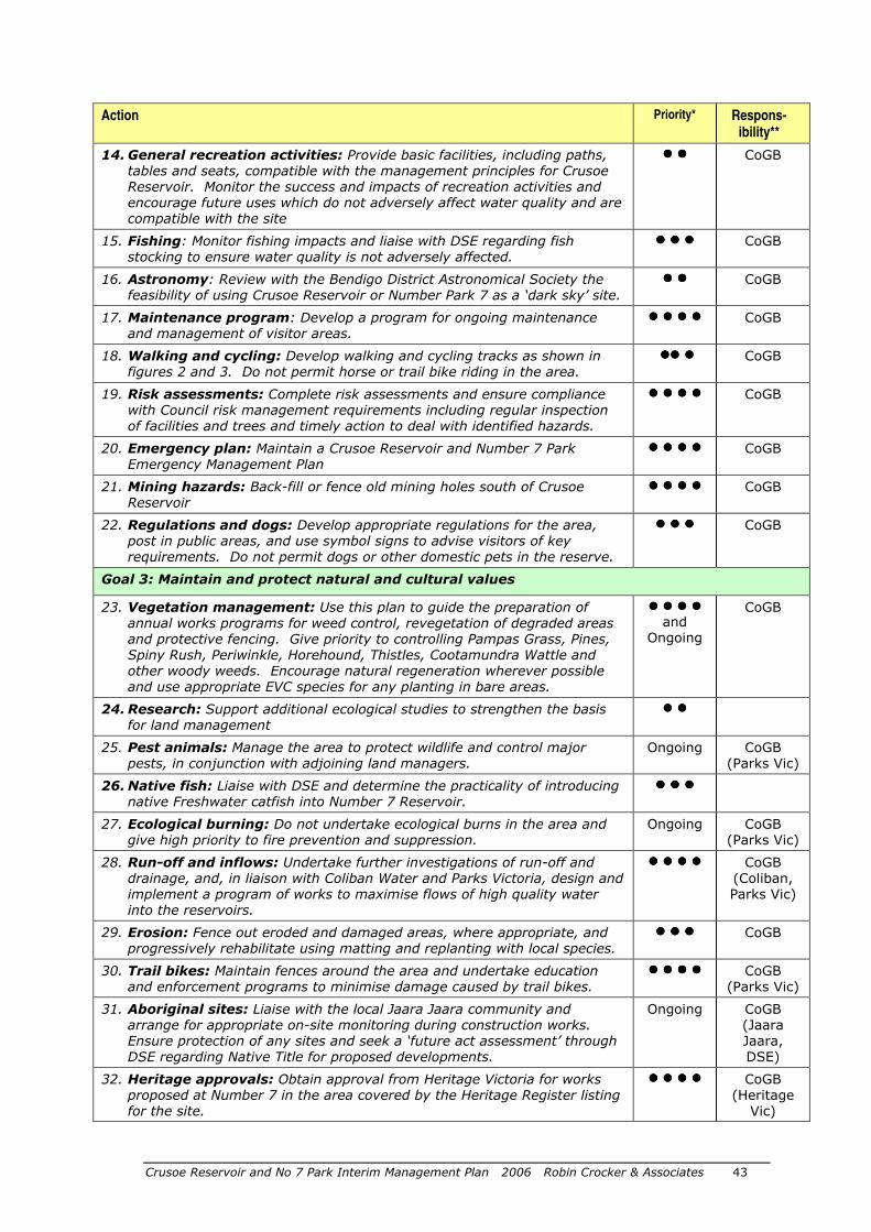
Crusoe Reservoir and No 7 Park Interim Management Plan 2006 Robin Crocker & Associates 43
Action Priority* Respons- ibility**
14. General recreation activities: Provide basic facilities, including paths, tables and seats, compatible with the management principles for Crusoe Reservoir. Monitor the success and impacts of recreation activities and encourage future uses which do not adversely affect water quality and are compatible with the site
���� ���� CoGB
15. Fishing: Monitor fishing impacts and liaise with DSE regarding fish stocking to ensure water quality is not adversely affected.
���� ���� ���� CoGB
16. Astronomy: Review with the Bendigo District Astronomical Society the feasibility of using Crusoe Reservoir or Number Park 7 as a ‘dark sky’ site.
���� ���� CoGB
17. Maintenance program: Develop a program for ongoing maintenance and management of visitor areas.
���� ���� ���� ���� CoGB
18. Walking and cycling: Develop walking and cycling tracks as shown in figures 2 and 3. Do not permit horse or trail bike riding in the area.
�������� ���� CoGB
19. Risk assessments: Complete risk assessments and ensure compliance with Council risk management requirements including regular inspection of facilities and trees and timely action to deal with identified hazards.
���� ���� ���� ���� CoGB
20. Emergency plan: Maintain a Crusoe Reservoir and Number 7 Park Emergency Management Plan
���� ���� ���� ���� CoGB
21. Mining hazards: Back-fill or fence old mining holes south of Crusoe Reservoir
���� ���� ���� ���� CoGB
22. Regulations and dogs: Develop appropriate regulations for the area, post in public areas, and use symbol signs to advise visitors of key requirements. Do not permit dogs or other domestic pets in the reserve.
���� ���� ���� CoGB
Goal 3: Maintain and protect natural and cultural values
23. Vegetation management: Use this plan to guide the preparation of annual works programs for weed control, revegetation of degraded areas and protective fencing. Give priority to controlling Pampas Grass, Pines, Spiny Rush, Periwinkle, Horehound, Thistles, Cootamundra Wattle and other woody weeds. Encourage natural regeneration wherever possible and use appropriate EVC species for any planting in bare areas.
���� ���� ���� ����
and Ongoing
CoGB
24. Research: Support additional ecological studies to strengthen the basis for land management
���� ����
25. Pest animals: Manage the area to protect wildlife and control major pests, in conjunction with adjoining land managers.
Ongoing CoGB (Parks Vic)
26. Native fish: Liaise with DSE and determine the practicality of introducing native Freshwater catfish into Number 7 Reservoir.
���� ���� ����
27. Ecological burning: Do not undertake ecological burns in the area and give high priority to fire prevention and suppression.
Ongoing CoGB (Parks Vic)
28. Run-off and inflows: Undertake further investigations of run-off and drainage, and, in liaison with Coliban Water and Parks Victoria, design and implement a program of works to maximise flows of high quality water into the reservoirs.
���� ���� ���� ���� CoGB (Coliban, Parks Vic)
29. Erosion: Fence out eroded and damaged areas, where appropriate, and progressively rehabilitate using matting and replanting with local species.
���� ���� ���� CoGB
30. Trail bikes: Maintain fences around the area and undertake education and enforcement programs to minimise damage caused by trail bikes.
���� ���� ���� ���� CoGB (Parks Vic)
31. Aboriginal sites: Liaise with the local Jaara Jaara community and arrange for appropriate on-site monitoring during construction works. Ensure protection of any sites and seek a ‘future act assessment’ through DSE regarding Native Title for proposed developments.
Ongoing CoGB (Jaara Jaara, DSE)
32. Heritage approvals: Obtain approval from Heritage Victoria for works proposed at Number 7 in the area covered by the Heritage Register listing for the site.
���� ���� ���� ���� CoGB (Heritage
Vic)
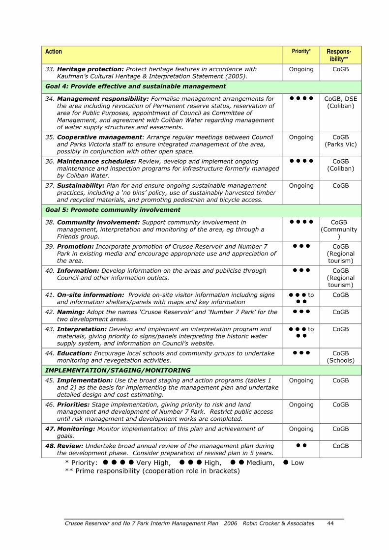
Crusoe Reservoir and No 7 Park Interim Management Plan 2006 Robin Crocker & Associates 44
Action Priority* Respons- ibility**
33. Heritage protection: Protect heritage features in accordance with Kaufman’s Cultural Heritage & Interpretation Statement (2005).
Ongoing CoGB
Goal 4: Provide effective and sustainable management
34. Management responsibility: Formalise management arrangements for the area including revocation of Permanent reserve status, reservation of area for Public Purposes, appointment of Council as Committee of Management, and agreement with Coliban Water regarding management of water supply structures and easements.
���� ���� ���� ���� CoGB, DSE (Coliban)
35. Cooperative management: Arrange regular meetings between Council and Parks Victoria staff to ensure integrated management of the area, possibly in conjunction with other open space.
Ongoing CoGB (Parks Vic)
36. Maintenance schedules: Review, develop and implement ongoing maintenance and inspection programs for infrastructure formerly managed by Coliban Water.
���� ���� ���� ���� CoGB (Coliban)
37. Sustainability: Plan for and ensure ongoing sustainable management practices, including a ‘no bins’ policy, use of sustainably harvested timber and recycled materials, and promoting pedestrian and bicycle access.
Ongoing CoGB
Goal 5: Promote community involvement
38. Community involvement: Support community involvement in management, interpretation and monitoring of the area, eg through a Friends group.
���� ���� ���� ���� CoGB (Community
)
39. Promotion: Incorporate promotion of Crusoe Reservoir and Number 7 Park in existing media and encourage appropriate use and appreciation of the area.
���� ���� ���� CoGB (Regional tourism)
40. Information: Develop information on the areas and publicise through Council and other information outlets.
���� ���� ���� CoGB (Regional tourism)
41. On-site information: Provide on-site visitor information including signs and information shelters/panels with maps and key information
���� ���� ���� to ���� ����
CoGB
42. Naming: Adopt the names ‘Crusoe Reservoir’ and ‘Number 7 Park’ for the two development areas.
���� ���� ���� CoGB
43. Interpretation: Develop and implement an interpretation program and materials, giving priority to signs/panels interpreting the historic water supply system, and information on Council’s website.
���� ���� ���� to ���� ����
CoGB
44. Education: Encourage local schools and community groups to undertake monitoring and revegetation activities.
���� ���� ���� CoGB (Schools)
IMPLEMENTATION/STAGING/MONITORING
45. Implementation: Use the broad staging and action programs (tables 1 and 2) as the basis for implementing the management plan and undertake detailed design and cost estimating.
Ongoing CoGB
46. Priorities: Stage implementation, giving priority to risk and land management and development of Number 7 Park. Restrict public access until risk management and development works are completed.
Ongoing CoGB
47. Monitoring: Monitor implementation of this plan and achievement of goals.
Ongoing CoGB
48. Review: Undertake broad annual review of the management plan during the development phase. Consider preparation of revised plan in 5 years.
���� ���� CoGB
* Priority: ���� ���� ���� ���� Very High, ���� ���� ���� High, ���� ���� Medium, ���� Low
** Prime responsibility (cooperation role in brackets)
Crusoe Reservoir and No 7 Park Interim Management Plan 2006 Robin Crocker & Associates 45
DSE 2003, Victoria’s Native Vegetation Management: A Framework for Action. Technical Support Maps for Local Government Authorities. Department of Sustainability and Environment, Victoria.
ECC 2001, Box-Ironbark Forests and Woodlands Investigation, Environment Conservation Council, Melbourne
Heart Foundation 2004, Healthy by Design: a planner’s guide to environments for active living, National Heart Foundation of Australia, (Victorian Division)
Goldfields Revegetation 2003, Flora Survey at Crusoe Reservoir, Bendigo, Nov 2003 (Copy held by CoGB)
Kaufman R, Cultural Heritage & Interpretation Statement – No 7 Reservoir, for City of Greater Bendigo, 2005
NRE 2002, Bendigo Region Fisheries Management Plan, Dept of Natural Resources and Environment
PV 1998, Churchill National Park and Lysterfield Lake Park Management Plan, Parks Victoria, Melbourne
RCA 1999, Robin Crocker and Associates, A Beach for Bendigo: Sandhurst Water Reserve Concept Development Plan, for City of Greater Bendigo, unpublished
RLSSA 2004a, Guidelines for Water Supply Safety in Urban Water Developments, Royal Life Saving Society of Australia
RLSSA 2004b, Aquatic and Recreational Signage Manual Style Guide, Royal Life Saving Society of Australia
SRV 2000, Sport and Recreation Victoria, The Active for Life Physical Activity Framework, 2000
SRV 2001, Sport and Recreation Victoria, Sport and Recreation Access for All – a guide to the design of accessible indoor and outdoor recreation and sporting facilities’, 2001
SunSmart 2004, Shade for everyone: A practical guide for shade development, The Cancer Council Victoria, Carlton
Waters, W, Lessons to be Learnt, Australian Leisure Management, June/July 2004
An additional source (not reviewed) is:
Rural Water Commission 1984, An Historical resume of Crusoe Reservoir, Armadale. Available in State Library of Victoria Call Number: SF 627.86 H62C
See also section 2.4.
Personal communications
David Bannear, DSE Phil Callan, National Health and Medical Research Council, 21.2.05 Bruce Duncan, Coliban water, 26.5.05 Dean Edwards, EPA, 7.3.05 Peter Fyffe, Coliban Water, 15.2.05 Eain McCrae, DSE, 1.6.05 Phil Neander and Mark Gilmour, CFA, 24.2.05 Brian Nelson, Parks Victoria, and Jason Kerr, 21.2.05 and 24.2.05 Graeme Oxlade, DSE, letter to CoGB, 4.11.03 Alistair Thom, Royal Life Saving Society of Australia, 17.2.05
7 References
Crusoe Reservoir and No 7 Park Interim Management Plan 2006 Robin Crocker & Associates 46
Appendix 1 Steering Committee
Members of the steering committee overseeing development of the plan:
• Cr David Jones (Chair) • Anthony Sheean (CoGB) • Mark Hands (CoGB) • Terry Huddle (CoGB) • Geoff Maguire (Capital Works Manager, CoGB) • Mark Guyer (Manager Parks and Natural Resources, CoGB) • Mitch Kemp (Ac/Manager Parks and Natural Resources, CoGB) • Roger Barbetti (Snr Parks Coordinator, CoGB) • Tim Buttle/David Major (Ranger/Ranger in Charge, Parks Victoria) • David Bannear (Regional Archaeology Advisor, DSE) • Bruce Duncan (Headworks manager, Coliban Water) • Graeme Oxlade (Case Manager CLM, DSE) • Robin Crocker (consultant team)
Appendices
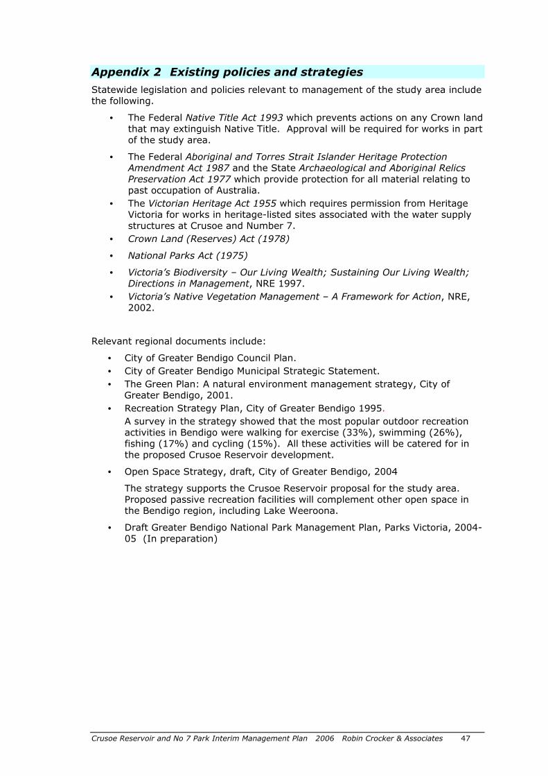
Crusoe Reservoir and No 7 Park Interim Management Plan 2006 Robin Crocker & Associates 47
Appendix 2 Existing policies and strategies
Statewide legislation and policies relevant to management of the study area include the following.
• The Federal Native Title Act 1993 which prevents actions on any Crown land that may extinguish Native Title. Approval will be required for works in part of the study area.
• The Federal Aboriginal and Torres Strait Islander Heritage Protection Amendment Act 1987 and the State Archaeological and Aboriginal Relics Preservation Act 1977 which provide protection for all material relating to past occupation of Australia.
• The Victorian Heritage Act 1955 which requires permission from Heritage Victoria for works in heritage-listed sites associated with the water supply structures at Crusoe and Number 7.
• Crown Land (Reserves) Act (1978)
• National Parks Act (1975)
• Victoria’s Biodiversity – Our Living Wealth; Sustaining Our Living Wealth; Directions in Management, NRE 1997.
• Victoria’s Native Vegetation Management – A Framework for Action, NRE, 2002.
Relevant regional documents include:
• City of Greater Bendigo Council Plan.
• City of Greater Bendigo Municipal Strategic Statement.
• The Green Plan: A natural environment management strategy, City of Greater Bendigo, 2001.
• Recreation Strategy Plan, City of Greater Bendigo 1995.
A survey in the strategy showed that the most popular outdoor recreation activities in Bendigo were walking for exercise (33%), swimming (26%), fishing (17%) and cycling (15%). All these activities will be catered for in the proposed Crusoe Reservoir development.
• Open Space Strategy, draft, City of Greater Bendigo, 2004
The strategy supports the Crusoe Reservoir proposal for the study area. Proposed passive recreation facilities will complement other open space in the Bendigo region, including Lake Weeroona.
• Draft Greater Bendigo National Park Management Plan, Parks Victoria, 2004-05 (In preparation)
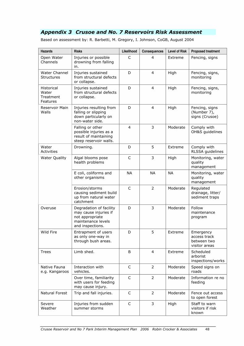
Crusoe Reservoir and No 7 Park Interim Management Plan 2006 Robin Crocker & Associates 48
Appendix 3 Crusoe and No. 7 Reservoirs Risk Assessment
Based on assessment by: R. Barbetti, M. Gregory, I. Johnson, CoGB, August 2004
Hazards Risks Likelihood Consequences Level of Risk Proposed treatment
Open Water Channels
Injuries or possible drowning from falling in.
C 4 Extreme Fencing, signs
Water Channel Structures
Injuries sustained from structural defects or collapse.
D 4 High Fencing, signs, monitoring
Historical Water Treatment Features
Injuries sustained from structural defects or collapse.
D 4 High Fencing, signs, monitoring
Reservoir Main Walls
Injuries resulting from falling or slipping down particularly on non-water side.
D 4 High Fencing, signs (Number 7), signs (Crusoe)
Falling or other possible injuries as a result of maintaining steep reservoir walls.
4 3 Moderate Comply with OH&S guidelines
Water Activities
Drowning. D 5 Extreme Comply with RLSSA guidelines
Algal blooms pose health problems
C 3 High Monitoring, water quality management
Water Quality
E coli, coliforms and other organisms
NA NA NA Monitoring, water quality management
Erosion/storms causing sediment build up from natural water catchment
C 2 Moderate Regulated drainage, litter/ sediment traps
Overuse Degradation of facility may cause injuries if not appropriate maintenance levels and inspections.
D 3 Moderate Follow maintenance program
Wild Fire Entrapment of users as only one-way in through bush areas.
D 5 Extreme Emergency access track between two visitor areas
Trees Limb shed. B 4 Extreme Scheduled arborist inspections/works
Native Fauna e.g. Kangaroos
Interaction with vehicles.
C 2 Moderate Speed signs on roads
Over time, familiarity with users for feeding may cause injury.
C 2 Moderate Information re no feeding
Natural Forest Trip and fall injuries. C 2 Moderate Fence out access to open forest
Severe Weather
Injuries from sudden summer storms
C 3 High Staff to warn visitors if risk known

Crusoe Reservoir and No 7 Park Interim Management Plan 2006 Robin Crocker & Associates 49
Hazards Risks Likelihood Consequences Level of Risk Proposed treatment
Inappropriate Usage
Vandalism due to isolated location.
B 2 High Regular patrols
Isolated location leads to area for drug use – discarded syringes pose risk to users.
D 2 Low Regular patrols, safe removal
Illegal use by horses, trail bikes or 4WD vehicles causes risk of injury or damage to vehicles or surround
D 3 Moderate Signs, regular patrols and enforcement
NA: Not assessed
Crusoe Reservoir and No 7 Park Interim Management Plan 2006 Robin Crocker & Associates 50
Appendix 4 Details of option for beach development
These notes are based on information provided in the 2005 Management Plan.
A review of visitor numbers at other recreation and tourism attractions in Bendigo, and of Lysterfield Lake Park and Lilydale Lake near Melbourne (which have popular beaches), suggest that a high quality beach development and associated passive recreation facilities at Crusoe could attract 100,000 to 200,000 visitors a year, once established. The beach would be a strong attraction in Bendigo’s hot summer climate.
� Vehicle entry and access The access proposals in the 2004 master plan were considered to still be appropriate.
It is desirable for public transport to be provided to the beach but it is assumed that private cars and group buses will be the main forms of transport in the short to medium term.
Primary access
The major access point to the Crusoe area will be from a point on Crusoe Road about 1 km west of the reservoir wall (figure 2). An engineering assessment and detailed design will be needed to ensure safe vehicle entry and exit. No access for public vehicles will be provided to the former works area off Crusoe Road below the reservoir wall.
Design components include:
• Direction signs to the park (from the Calder Highway and on Crusoe Road). • Appropriate turning lanes and a well graded and aligned entry road from
Crusoe Road. • An attractive entrance. • A CoGB name sign (‘Bendigo Beach’ with key rule symbols) – to conform
with Council’s Style Manual • Information on opening hours, facilities and key regulations. • A boom gate to regulate entry, and an exit lane with a mechanism allowing
exit only. • A mechanism for a coin operated boom gate or arrangements for fee
collection. • Appropriate fencing to prevent vehicles from leaving the entry road, and to
restrict trail bike and other access along the Specimen Hill Channel. • A small carpark near the entrance for walkers and cyclists using the park
after hours. • A sealed road, largely along the existing management track alignment,
providing visitor access to the beach and bushland.
Park opening and closing times should be determined by Council in accordance with current policy for other venues. Closing times of about 5 PM in winter and 9 PM is summer may be appropriate.
Emergency access
An emergency exit/management track is proposed, based on an existing track, linking the main carpark near the beach with the Number 7 picnic area. Most other existing management tracks should also be maintained for ongoing management use. Coliban Water will require regular access to channels and other infrastructure for operational purposes.
Secondary access
A secondary access point is proposed near the spillway, at the north end of the Crusoe reservoir wall. An existing access track off Crusoe Road would be used and
Crusoe Reservoir and No 7 Park Interim Management Plan 2006 Robin Crocker & Associates 51
a simple access ramp provided to the water’s edge. This access point would only be used by organised groups using the reservoir for sailing or similar activities, and for management or emergency access. Existing gates and fencing would be retained and signs installed and parking, etc defined.
The demand for sailing or similar use is unclear and development of this area should be deferred, except for emergency access, until a specific use is identified which meets with Council recreation objectives.
Proposed actions
� Crusoe public access: Provide a major public entry point off Crusoe Road with a sealed access road (to the beach area), gates, fencing, signs, information and a small entrance carpark.
� Crusoe restricted access: Provide a restricted access point near the north end of the reservoir wall for management purposes and for group water-based uses, when demand is demonstrated.
� Parking Providing adequate parking for cars and buses is a key requirement if the beach is to be successful. Following an assessment of cleared and degraded areas near the beach, a design was developed which minimised disturbance to indigenous vegetation and provides about 110 car and 4 bus spaces within easy walking distance of the beach. Provision also needs to be provided for a refreshment van.
About 120 additional spaces will be provided in largely cleared areas beside the road to the beach carpark. Additional cleared areas near the entrance road would provide for overflow parking. These areas will have walking track access to the beach area.
Any removal of native vegetation is to be in accordance with current state government requirements, with provision for net gain.
Careful design of drainage from parking areas and roads (including sediment and litter traps etc) will be essential to minimise flow of sediment, plant debris and pollutants into the reservoir.
A second minor carpark is proposed (in the long-term) near the spillway at the north end of the reservoir wall for group water-based activities. This would have 20-30 spaces and be located largely on existing surfaced areas.
Parking areas and associated roads will need to be fenced to contain vehicles and deter visitors from walking into bushland areas.
Proposed actions
� Beach parking: Develop sealed parking areas to cater for visitors to the beach, reservoir and surrounding bushland, designed to minimise disturbance to indigenous vegetation and impacts on water quality in the reservoir.
� Overflow parking: Develop unsealed overflow parking to cater for beach visitors on busy days.
� Spillway parking: Define parking areas (with regulated access) at north end of reservoir wall if/when area developed.
� Beach development and water-based recreation
Beach
The proposed beach is a key feature of the proposed development and must provide for enjoyable recreation experiences in a well-managed bushland setting. The siting and design of the beach is based on the recommendations of experienced
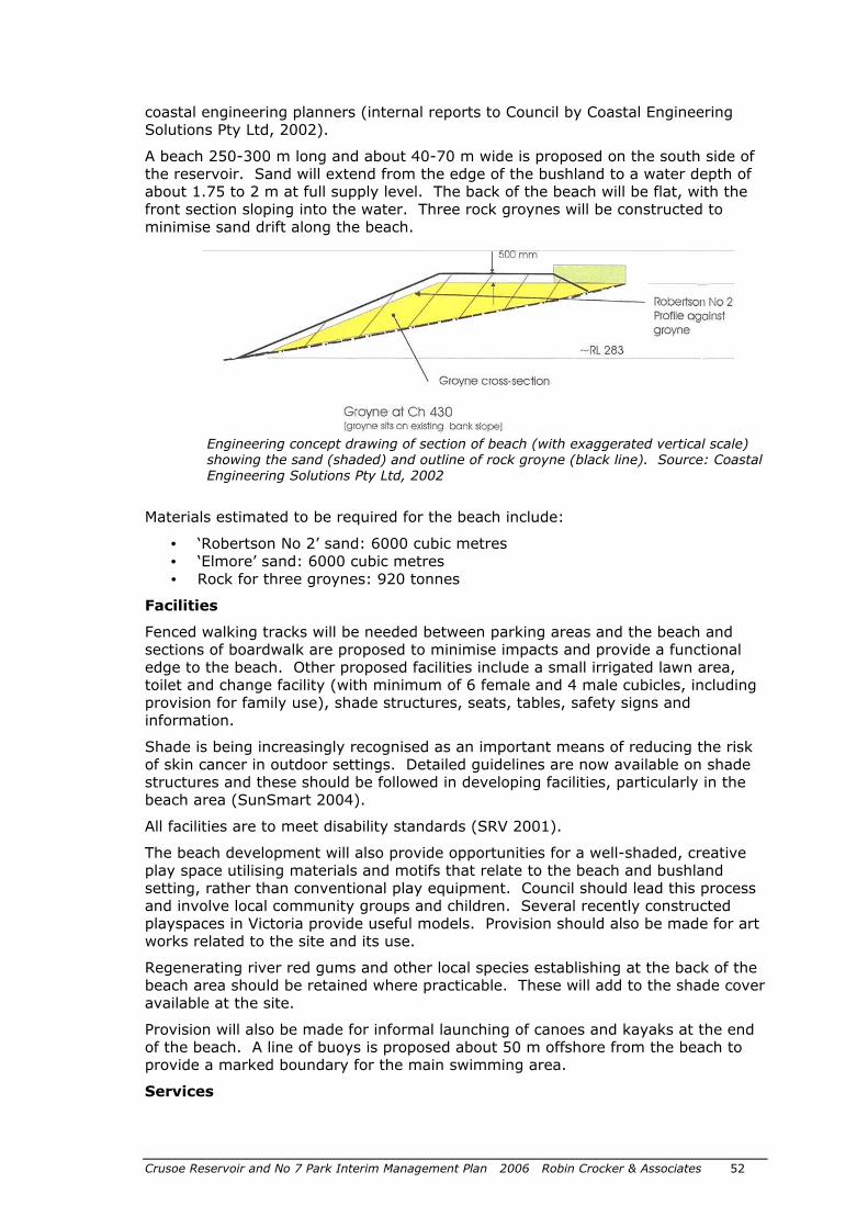
Crusoe Reservoir and No 7 Park Interim Management Plan 2006 Robin Crocker & Associates 52
coastal engineering planners (internal reports to Council by Coastal Engineering Solutions Pty Ltd, 2002).
A beach 250-300 m long and about 40-70 m wide is proposed on the south side of the reservoir. Sand will extend from the edge of the bushland to a water depth of about 1.75 to 2 m at full supply level. The back of the beach will be flat, with the front section sloping into the water. Three rock groynes will be constructed to minimise sand drift along the beach.
Engineering concept drawing of section of beach (with exaggerated vertical scale) showing the sand (shaded) and outline of rock groyne (black line). Source: Coastal Engineering Solutions Pty Ltd, 2002
Materials estimated to be required for the beach include:
• ‘Robertson No 2’ sand: 6000 cubic metres • ‘Elmore’ sand: 6000 cubic metres • Rock for three groynes: 920 tonnes
Facilities
Fenced walking tracks will be needed between parking areas and the beach and sections of boardwalk are proposed to minimise impacts and provide a functional edge to the beach. Other proposed facilities include a small irrigated lawn area, toilet and change facility (with minimum of 6 female and 4 male cubicles, including provision for family use), shade structures, seats, tables, safety signs and information.
Shade is being increasingly recognised as an important means of reducing the risk of skin cancer in outdoor settings. Detailed guidelines are now available on shade structures and these should be followed in developing facilities, particularly in the beach area (SunSmart 2004).
All facilities are to meet disability standards (SRV 2001).
The beach development will also provide opportunities for a well-shaded, creative play space utilising materials and motifs that relate to the beach and bushland setting, rather than conventional play equipment. Council should lead this process and involve local community groups and children. Several recently constructed playspaces in Victoria provide useful models. Provision should also be made for art works related to the site and its use.
Regenerating river red gums and other local species establishing at the back of the beach area should be retained where practicable. These will add to the shade cover available at the site.
Provision will also be made for informal launching of canoes and kayaks at the end of the beach. A line of buoys is proposed about 50 m offshore from the beach to provide a marked boundary for the main swimming area.
Services
Crusoe Reservoir and No 7 Park Interim Management Plan 2006 Robin Crocker & Associates 53
Sustainable management of the site is a high priority and options were investigated for the provision of electricity, sewerage disposal and drinking water to the beach area.
Sewage disposal
A sewer main located alongside Crusoe Road near Furness Street provides an opportunity to connect to the sewer. This is the EPA’s preferred option.
Septic tanks and composting toilets were investigated as alternatives but considered to be unsuitable for use by large numbers of people so close to a major swimming facility. A septic system would have to be sealed and pumped out regularly. Composing toilets need to be elevated, require additional pump-out hand washing facilities and require significant ongoing maintenance in Victoria. An attractive, easy to use, ground level toilet facility is considered to be essential to promote good hygiene near the swimming area.
Electricity
Power will be required for lighting, barbecues, pumping water to the amenities block, and a range of management tasks. Solar power was considered but conventional electricity supply is considered to be the most appropriate for the site.
Drinking water
Piping water from Crusoe Reservoir to drinking taps in the beach area (or collecting rainwater) is unlikely to comply with health regulations. Piping in town water is proposed, with all services laid in the same trench.
Construction
Native Title needs to be considered (in consultation with DSE) prior to undertaking any construction activities.
Construction of the beach, roads and other services and facilities will require use of heavy-duty equipment. The works must be managed to minimise impacts on natural values, eg by specifying the size and types of equipment which can be used, and clearly marking no-go areas. This work must be in accordance with the Environmental Guidelines for Major Construction Sites (EPA publication 480) and Construction Techniques for Sediment Pollution Control (EPA publication 275) (Edwards, pers. comm.).
Works also need be undertaken with appropriate monitoring by representatives of Aboriginal communities (Nelson and Kerr pers comm.)
Proposed actions
� Beach construction: Prepare detailed construction specifications and develop the beach. Ensure protection of soils and indigenous woodland vegetation and comply with EPA publications 275 and 480. Provide for monitoring by Aboriginal representatives.
� Facilities provision: Prepare detailed construction specifications and develop adjacent visitor facilities. Include specialist works and fencing to protect soils and indigenous woodland vegetation.
� Services provision: Provide for sewer connection at the main beach facilities, electricity, and drinking water.
� Art and play: Provide for art works and a playspace in cooperation with community groups.
� Maintenance program: Develop a detailed program for ongoing maintenance and management of the beach and other visitor areas. Include provision for cleaning, rubbish removal, repair and replacement, and maintenance of tracks.
Crusoe Reservoir and No 7 Park Interim Management Plan 2006 Robin Crocker & Associates 54
� Water level: Monitor the water level in Crusoe Reservoir and negotiate with Coliban Water for additional inflow if appropriate.
� Other facilities and activities Recreation activities at similar reserves were reviewed and discussions held to identify opportunities at Crusoe. If a beach is developed, the focus at Crusoe will be on swimming and associated recreation that does not adversely affect water quality. For this reason high-impact activities will not be permitted and clubrooms and other built facilities, except for toilets and change rooms, will not be provided.
Canoeing / kayaks
Lake Weeroona currently provides adequately for club-based canoeing. Crusoe provides opportunities for limited summer club use and for informal canoeing and kayaking. These activities need to be separated from the swimming area.
Boating
Because of the small size of the reservoir, the need to maintain water quality and potential conflicts with other users, no power boating will be allowed, including use of electric motors and model boats. Only small, lightweight craft carried on car roof-racks will be permitted. Space will not be available for trailer parking at the main beach carpark.
Sailing, model yachts
Sailing opportunities will be limited by the size of the reservoir, the sheltered site and potential conflicts with other users. The site proposed in the concept plan near the spillway is the most logical. Given the small size of the reservoir, launching from trailers using a boat ramp is not appropriate.
Organised use, eg by Sailability Victoria or the YMCA, for children and people with disabilities seems most appropriate. No significant short-demand for this use has been identified.
Remote-controlled yachts may be an appropriate use if demand is demonstrated. A suitable site would need to be identified. A pontoon may be needed for launching.
Rowing
The limited size of the reservoir and provision of adequate facilities at Lake Weeroona indicate that Crusoe has limited potential for rowing. Any future rowing activities need to be located near the reservoir wall, away from the beach.
Sailboarding
Crusoe appears to be too small for successful sailboarding and conflicts with other users appear likely. Future opportunities for this use should be reviewed later.
Fishing / fly casting
Shoreline fishing should only be permitted in a designated area away from the beach to minimise any impacts on other users and water quality. A section of the reservoir, east of the beach, towards the reservoir wall, is proposed
Beach volleyball
Crusoe is not considered to be a suitable venue for beach volleyball.
Other events and activities
The primary purpose of the site is to provide for informal swimming and beach going, not a venue for events that are better provided for elsewhere in Bendigo. The site may also be suitable for some small-scale community-based activities and
Crusoe Reservoir and No 7 Park Interim Management Plan 2006 Robin Crocker & Associates 55
events provided natural values are not adversely affected and facilities are adequate. The existing Council booking system for events would be used.
Refreshments
It is very unlikely that a built food outlet would be viable at Crusoe and its construction and operation would impose additional impacts on the site. A mobile refreshment van is considered appropriate with the operator responsible for regular removal of associated rubbish from the site. A tender process should be used to select an appropriate vendor.
Equipment hire
There may be some opportunities for hire of watercraft such as canoes, kayaks and paddleboats, however insurance and safety must be considered. No storage should be provided on-site.
Proposed actions
� General recreation activities: Provide for other agreed recreation activities, facilities and services compatible with the management principles for Crusoe Reservoir. Monitor the success and impacts of recreation activities and encourage future uses which do not adversely affect water quality and are compatible with the site.
� Fishing: Monitor fishing impacts and liaise with DSE regarding fish stocking to ensure water quality is not adversely affected.
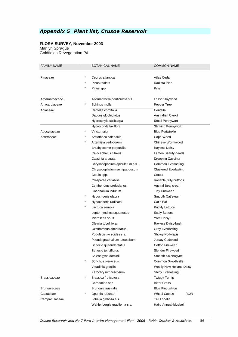
Crusoe Reservoir and No 7 Park Interim Management Plan 2006 Robin Crocker & Associates 56
Appendix 5 Plant list, Crusoe Reservoir
FLORA SURVEY, November 2003 Marilyn Sprague Goldfields Revegetation P/L
FAMILY NAME BOTANICAL NAME COMMON NAME
CONIFERS
Pinaceae * Cedrus atlantica Atlas Cedar
* Pinus radiata Radiata Pine
* Pinus spp. Pine
DICOTYLED
Amaranthaceae Alternanthera denticulata s.s. Lesser Joyweed
Anacardiaceae * Schinus molle Pepper Tree
Apiaceae Centella cordifolia Centella
Daucus glochidiatus Australian Carrot
Hydrocotyle callicarpa Small Pennywort
Hydrocotyle laxiflora Stinking Pennywort
Apocynaceae * Vinca major Blue Periwinkle
Asteraceae * Arctotheca calendula Cape Weed
* Artemisia verlotiorum Chinese Wormwood
Brachyscome perpusilla Rayless Daisy
Calocephalus citreus Lemon Beauty-heads
Cassinia arcuata Drooping Cassinia
Chrysocephalum apiculatum s.s. Common Everlasting
Chrysocephalum semipapposum Clustered Everlasting
Cotula spp. Cotula
Craspedia variabilis Variable Billy-buttons
Cymbonotus preissianus Austral Bear’s-ear
Gnaphalium indutum Tiny Cudweed
* Hypochoeris glabra Smooth Cat’s-ear
* Hypochoeris radicata Cat’s Ear
* Lactuca serriola Prickly Lettuce
Leptorhynchos squamatus Scaly Buttons
Microseris sp. 3 Yam Daisy
Olearia tubuliflora Rayless Daisy-bush
Ozothamnus obcordatus Grey Everlasting
Podolepis jaceoides s.s. Showy Podolepis
Pseudognaphalium luteoalbum Jersey Cudweed
Senecio quadridentatus Cotton Fireweed
Senecio tenuiflorus Slender Fireweed
Solenogyne dominii Smooth Solenogyne
* Sonchus oleraceus Common Sow-thistle
Vittadinia gracilis Woolly New Holland Daisy
Xerochrysum viscosum Shiny Everlasting
Brassicaceae * Brassica fruticulosa Twiggy Turnip
Cardamine spp. Bitter Cress
Brunoniaceae Brunonia australis Blue Pincushion
Cactaceae * Opuntia robusta Wheel Cactus RCW
Campanulaceae Lobelia gibbosa s.s. Tall Lobelia
Wahlenbergia gracilenta s.s. Hairy Annual-bluebell
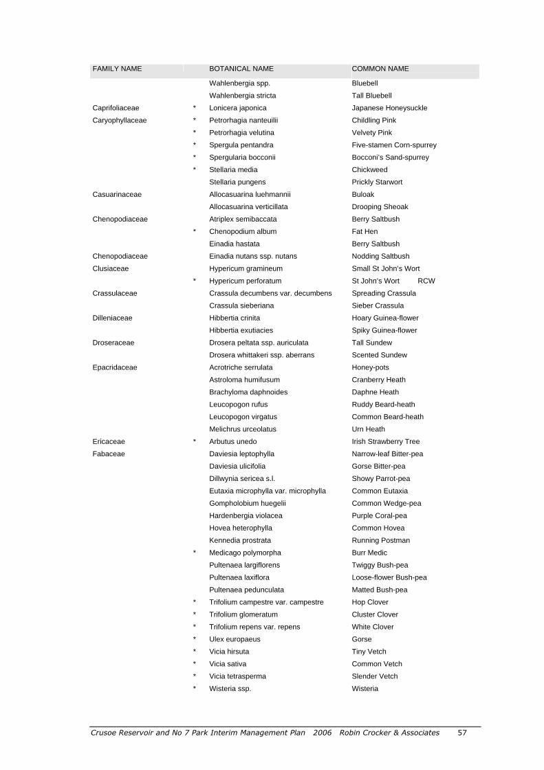
Crusoe Reservoir and No 7 Park Interim Management Plan 2006 Robin Crocker & Associates 57
FAMILY NAME BOTANICAL NAME COMMON NAME
Wahlenbergia spp. Bluebell
Wahlenbergia stricta Tall Bluebell
Caprifoliaceae * Lonicera japonica Japanese Honeysuckle
Caryophyllaceae * Petrorhagia nanteuilii Childling Pink
* Petrorhagia velutina Velvety Pink
* Spergula pentandra Five-stamen Corn-spurrey
* Spergularia bocconii Bocconi’s Sand-spurrey
* Stellaria media Chickweed
Stellaria pungens Prickly Starwort Casuarinaceae Allocasuarina luehmannii Buloak
Allocasuarina verticillata Drooping Sheoak
Chenopodiaceae Atriplex semibaccata Berry Saltbush
* Chenopodium album Fat Hen
Einadia hastata Berry Saltbush
Chenopodiaceae Einadia nutans ssp. nutans Nodding Saltbush
Clusiaceae Hypericum gramineum Small St John’s Wort
* Hypericum perforatum St John’s Wort RCW
Crassulaceae Crassula decumbens var. decumbens Spreading Crassula
Crassula sieberiana Sieber Crassula
Dilleniaceae Hibbertia crinita Hoary Guinea-flower
Hibbertia exutiacies Spiky Guinea-flower
Droseraceae Drosera peltata ssp. auriculata Tall Sundew
Drosera whittakeri ssp. aberrans Scented Sundew
Epacridaceae Acrotriche serrulata Honey-pots
Astroloma humifusum Cranberry Heath
Brachyloma daphnoides Daphne Heath
Leucopogon rufus Ruddy Beard-heath
Leucopogon virgatus Common Beard-heath
Melichrus urceolatus Urn Heath
Ericaceae * Arbutus unedo Irish Strawberry Tree
Fabaceae Daviesia leptophylla Narrow-leaf Bitter-pea
Daviesia ulicifolia Gorse Bitter-pea
Dillwynia sericea s.l. Showy Parrot-pea
Eutaxia microphylla var. microphylla Common Eutaxia
Gompholobium huegelii Common Wedge-pea
Hardenbergia violacea Purple Coral-pea
Hovea heterophylla Common Hovea
Kennedia prostrata Running Postman
* Medicago polymorpha Burr Medic
Pultenaea largiflorens Twiggy Bush-pea
Pultenaea laxiflora Loose-flower Bush-pea
Pultenaea pedunculata Matted Bush-pea
* Trifolium campestre var. campestre Hop Clover
* Trifolium glomeratum Cluster Clover
* Trifolium repens var. repens White Clover
* Ulex europaeus Gorse
* Vicia hirsuta Tiny Vetch
* Vicia sativa Common Vetch
* Vicia tetrasperma Slender Vetch
* Wisteria ssp. Wisteria
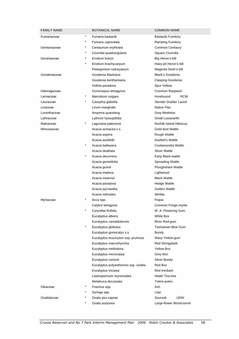
Crusoe Reservoir and No 7 Park Interim Management Plan 2006 Robin Crocker & Associates 58
FAMILY NAME BOTANICAL NAME COMMON NAME
Fumariaceae * Fumaria bastardii Bastards Fumitory
* Fumaria capreolata Ramping Fumitory
Gentianaceae * Centaurium erythraea Common Centaury
* Cicendia quadrangularis Square Cicendia
Geraniaceae * Erodium botrys Big Heron’s-bill
* Erodium brachycarpum Hairy-pit Heron’s-bill
Pelargonium rodneyanum Magenta Stork’s-bill
Goodeniaceae Goodenia blackiana Black’s Goodenia
Goodenia benthamiana Clasping Goodenia
Velleia paradoxa Spur Velleia
Haloragaceae Gonocarpus tetragynus Common Raspwort
Lamiaceae * Marrubium vulgare Horehound RCW
Lauraceae * Cassytha glabella Slender Dodder Laurel
Linaceae Linum marginale Native Flax
Loranthaceae Amyema quandang Grey Mistletoe
Lythraceae Lythrum hyssopifolia Small Loosestrife
Malvaceae * Lagunaria patersonii Norfolk Island Hibiscus
Mimosaceae Acacia acinacea s.s. Gold-dust Wattle
Acacia aspera Rough Wattle
Acacia ausfeldii Ausfeld’s Wattle
* Acacia baileyana Cootamundra Wattle
Acacia dealbata Silver Wattle
* Acacia decurrens Early Black-wattle
Acacia genistifolia Spreading Wattle
Acacia gunnii Ploughshare Wattle
Acacia implexa Lightwood
Acacia mearnsii Black Wattle
Acacia paradoxa Hedge Wattle
Acacia pycnantha Golden Wattle
Acacia retinodes Wirilda
Myrtaceae * Acca spp. Feijoa
Calytrix tetragona Common Fringe-myrtle
* Corymbia ficifolia W. A. Flowering Gum
Eucalyptus albens White Box
Eucalyptus camaldulensis River Red-gum
* Eucalyptus globulus Tasmanian Blue Gum
Eucalyptus goniocalyx s.s. Bundy
Eucalyptus leucoxylon ssp. pruinosa Waxy Yellow-gum
Eucalyptus macrorhyncha Red Stringybark
Eucalyptus melliodora Yellow Box
Eucalyptus microcarpa Grey Box
Eucalyptus nortonii Silver Bundy
Eucalyptus polyanthemos ssp. vestita Red Box
Eucalyptus tricarpa Red Ironbark
Leptospermum myrsinoides Heath Tea-tree
Melaleuca decussata Totem-poles
Oleaceae * Fraxinus spp. Ash
* Syringa spp. Lilac
Oxalidaceae * Oxalis pes-caprae Soursob UDW
* Oxalis purpurea Large-flower Wood-sorrel
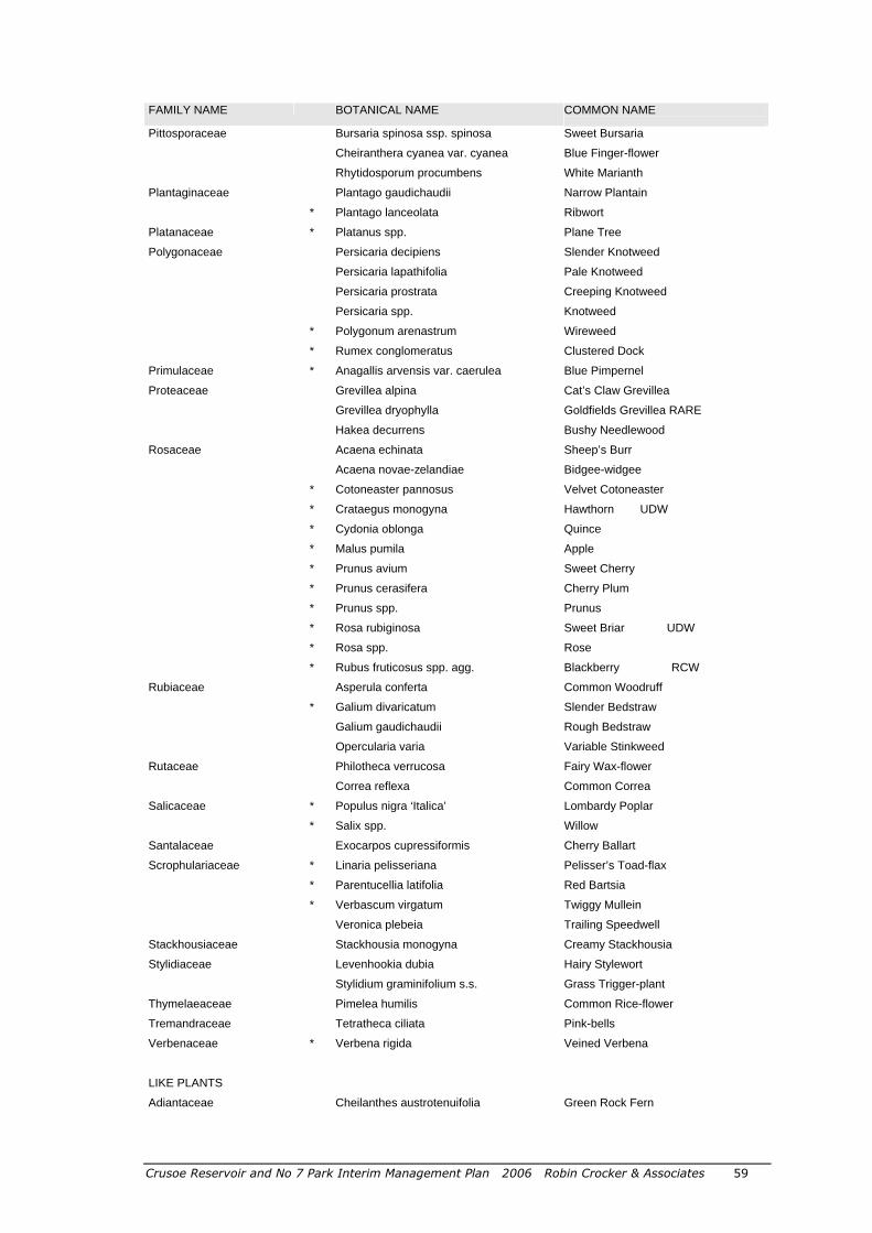
Crusoe Reservoir and No 7 Park Interim Management Plan 2006 Robin Crocker & Associates 59
FAMILY NAME BOTANICAL NAME COMMON NAME
Pittosporaceae Bursaria spinosa ssp. spinosa Sweet Bursaria
Cheiranthera cyanea var. cyanea Blue Finger-flower
Rhytidosporum procumbens White Marianth
Plantaginaceae Plantago gaudichaudii Narrow Plantain
* Plantago lanceolata Ribwort
Platanaceae * Platanus spp. Plane Tree
Polygonaceae Persicaria decipiens Slender Knotweed
Persicaria lapathifolia Pale Knotweed
Persicaria prostrata Creeping Knotweed
Persicaria spp. Knotweed
* Polygonum arenastrum Wireweed
* Rumex conglomeratus Clustered Dock
Primulaceae * Anagallis arvensis var. caerulea Blue Pimpernel
Proteaceae Grevillea alpina Cat’s Claw Grevillea
Grevillea dryophylla Goldfields Grevillea RARE Hakea decurrens Bushy Needlewood
Rosaceae Acaena echinata Sheep’s Burr
Acaena novae-zelandiae Bidgee-widgee
* Cotoneaster pannosus Velvet Cotoneaster
* Crataegus monogyna Hawthorn UDW
* Cydonia oblonga Quince
* Malus pumila Apple
* Prunus avium Sweet Cherry
* Prunus cerasifera Cherry Plum
* Prunus spp. Prunus
* Rosa rubiginosa Sweet Briar UDW
* Rosa spp. Rose
* Rubus fruticosus spp. agg. Blackberry RCW
Rubiaceae Asperula conferta Common Woodruff
* Galium divaricatum Slender Bedstraw
Galium gaudichaudii Rough Bedstraw
Opercularia varia Variable Stinkweed
Rutaceae Philotheca verrucosa Fairy Wax-flower
Correa reflexa Common Correa
Salicaceae * Populus nigra ‘Italica’ Lombardy Poplar
* Salix spp. Willow
Santalaceae Exocarpos cupressiformis Cherry Ballart
Scrophulariaceae * Linaria pelisseriana Pelisser’s Toad-flax
* Parentucellia latifolia Red Bartsia
* Verbascum virgatum Twiggy Mullein
Veronica plebeia Trailing Speedwell
Stackhousiaceae Stackhousia monogyna Creamy Stackhousia
Stylidiaceae Levenhookia dubia Hairy Stylewort
Stylidium graminifolium s.s. Grass Trigger-plant
Thymelaeaceae Pimelea humilis Common Rice-flower
Tremandraceae Tetratheca ciliata Pink-bells
Verbenaceae * Verbena rigida Veined Verbena
FERNS AND
LIKE PLANTS
Adiantaceae Cheilanthes austrotenuifolia Green Rock Fern
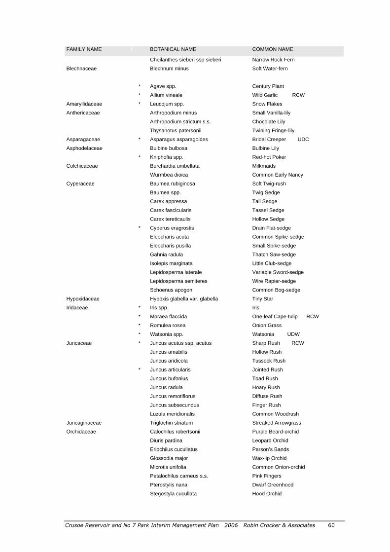
Crusoe Reservoir and No 7 Park Interim Management Plan 2006 Robin Crocker & Associates 60
FAMILY NAME BOTANICAL NAME COMMON NAME
Cheilanthes sieberi ssp sieberi Narrow Rock Fern
Blechnaceae Blechnum minus Soft Water-fern
MONOCOTY
Agavaceae
* Agave spp. Century Plant
Alliaceae
* Allium vineale Wild Garlic RCW
Amaryllidaceae * Leucojum spp. Snow Flakes
Anthericaceae Arthropodium minus Small Vanilla-lily
Arthropodium strictum s.s. Chocolate Lily
Thysanotus patersonii Twining Fringe-lily
Asparagaceae * Asparagus asparagoides Bridal Creeper UDC
Asphodelaceae Bulbine bulbosa Bulbine Lily
* Kniphofia spp. Red-hot Poker
Colchicaceae Burchardia umbellata Milkmaids
Wurmbea dioica Common Early Nancy
Cyperaceae Baumea rubiginosa Soft Twig-rush
Baumea spp. Twig Sedge
Carex appressa Tall Sedge
Carex fascicularis Tassel Sedge
Carex tereticaulis Hollow Sedge
* Cyperus eragrostis Drain Flat-sedge
Eleocharis acuta Common Spike-sedge
Eleocharis pusilla Small Spike-sedge
Gahnia radula Thatch Saw-sedge
Isolepis marginata Little Club-sedge
Lepidosperma laterale Variable Sword-sedge
Lepidosperma semiteres Wire Rapier-sedge
Schoenus apogon Common Bog-sedge
Hypoxidaceae Hypoxis glabella var. glabella Tiny Star
Iridaceae * Iris spp. Iris
* Moraea flaccida One-leaf Cape-tulip RCW
* Romulea rosea Onion Grass
* Watsonia spp. Watsonia UDW
Juncaceae * Juncus acutus ssp. acutus Sharp Rush RCW
Juncus amabilis Hollow Rush
Juncus aridicola Tussock Rush
* Juncus articularis Jointed Rush
Juncus bufonius Toad Rush
Juncus radula Hoary Rush
Juncus remotiflorus Diffuse Rush
Juncus subsecundus Finger Rush
Luzula meridionalis Common Woodrush
Juncaginaceae Triglochin striatum Streaked Arrowgrass
Orchidaceae Calochilus robertsonii Purple Beard-orchid
Diuris pardina Leopard Orchid
Eriochilus cucullatus Parson’s Bands
Glossodia major Wax-lip Orchid
Microtis unifolia Common Onion-orchid
Petalochilus carneus s.s. Pink Fingers
Pterostylis nana Dwarf Greenhood
Stegostyla cucullata Hood Orchid
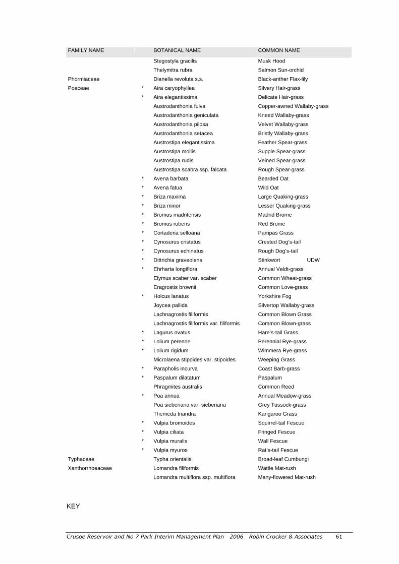
Crusoe Reservoir and No 7 Park Interim Management Plan 2006 Robin Crocker & Associates 61
FAMILY NAME BOTANICAL NAME COMMON NAME
Stegostyla gracilis Musk Hood
Thelymitra rubra Salmon Sun-orchid
Phormiaceae Dianella revoluta s.s. Black-anther Flax-lily
Poaceae * Aira caryophyllea Silvery Hair-grass
* Aira elegantissima Delicate Hair-grass
Austrodanthonia fulva Copper-awned Wallaby-grass
Austrodanthonia geniculata Kneed Wallaby-grass
Austrodanthonia pilosa Velvet Wallaby-grass
Austrodanthonia setacea Bristly Wallaby-grass
Austrostipa elegantissima Feather Spear-grass
Austrostipa mollis Supple Spear-grass
Austrostipa rudis Veined Spear-grass
Austrostipa scabra ssp. falcata Rough Spear-grass
* Avena barbata Bearded Oat
* Avena fatua Wild Oat
* Briza maxima Large Quaking-grass
* Briza minor Lesser Quaking-grass
* Bromus madritensis Madrid Brome
* Bromus rubens Red Brome
* Cortaderia selloana Pampas Grass
* Cynosurus cristatus Crested Dog’s-tail
* Cynosurus echinatus Rough Dog’s-tail
* Dittrichia graveolens Stinkwort UDW
* Ehrharta longiflora Annual Veldt-grass
Elymus scaber var. scaber Common Wheat-grass
Eragrostis brownii Common Love-grass
* Holcus lanatus Yorkshire Fog
Joycea pallida Silvertop Wallaby-grass
Lachnagrostis filiformis Common Blown Grass
Lachnagrostis filiformis var. filiformis Common Blown-grass
* Lagurus ovatus Hare’s-tail Grass
* Lolium perenne Perennial Rye-grass
* Lolium rigidum Wimmera Rye-grass
Microlaena stipoides var. stipoides Weeping Grass
* Parapholis incurva Coast Barb-grass
* Paspalum dilatatum Paspalum
Phragmites australis Common Reed
* Poa annua Annual Meadow-grass
Poa sieberiana var. sieberiana Grey Tussock-grass
Themeda triandra Kangaroo Grass
* Vulpia bromoides Squirrel-tail Fescue
* Vulpia ciliata Fringed Fescue
* Vulpia muralis Wall Fescue
* Vulpia myuros Rat’s-tail Fescue
Typhaceae Typha orientalis Broad-leaf Cumbungi
Xanthorrhoeaceae Lomandra filiformis Wattle Mat-rush
Lomandra multiflora ssp. multiflora Many-flowered Mat-rush
KEY

Crusoe Reservoir and No 7 Park Interim Management Plan 2006 Robin Crocker & Associates 62
* Non-indigenous species surveyed on site. RCW – Regionally Controlled Weed UDW – Undeclared Weed There were 274 species surveyed at Crusoe Reservoir. This includes 102 introduced species and also native species which have spread beyond their natural range. There were 172 indigenous species surveyed. Unfortunately, many species were unable to be identified to species level due to time of the year of survey, particularly early flowering orchids and summer dormant herbaceous species. Weed classification is from ‘Weeds of the North Central Region’ State of Victoria, Department of Primary Industries, 2003. Taxonomy The plant taxonomy used in this report follows the Flora Information System (FIS 2003) of the Victorian Department of Sustainability and Environment. Marilyn Sprague Goldfields Revegetation P/L 230 Tannery Lane Mandurang 3551 Ph 5439 5384