Embed Size (px)
Citation preview
Climate and Permafrost 43
Cryogenetic mounds as indicators of permafrost conditions, northern QuCbec
DANIEL LAGAREC Dkpartement de Gkographie, Universitk dJOttawa, Ottawa, Ontario, Canada KIN 6N5
Along the east coast of Hudson Bay, palsas and related cryogenic mounds are easily discernable evi- dence of the presence of permafrost. Analysis of their distribution shows a zonation oriented NE-SW, approximately parallel to the shore. In the first zone, within 20 km of the shore and mainly north of Richmond Gulf, peat-bogs are scarce and mineral cryogenic mounds occur in most locations where surficial deposits exist. In the second zone, peatzbogs are more widespread and permafrost is found both in surficial deposits (mineral cryogenic mounds) and peat-bogs (palsas). South of 56" N, towards the interior, string-bogs are the dominant type of peat-bogs, with occasional partially collapsed palsas.
Permafrost has been more widespread in the region in the recent past, and its extent is now decreas- ing. In areas of discontinuous permafrost such as that of the study, the distribution of palsas and related cryogenic mounds is a good indicator of the extent and general conditions of permafrost.
Sur le littoral Est de la Mer d'Hudson les palses et autres buttes cryogtnes sont les evidences les plus nettes de la presence de pergelisol.
L'analywde leur distribution montre une zonation en bandes orientee NE-SW, plus ou moins paralltles au rivage. Dans la premitre bande, large d'environ 20 km a partir du littoral, et au Nord du Golfe de Richmond, les tourbikres sont rares et les buttes cryogtnes minerales sont presentes partout ou il y a des dtpBts de surface. Dans la deuxieme, les tourbitres sont plus repandues et le pergelisol se rencontre a la fois dans les terrains mineraux et dans les tourbikres. Au Sud du 56kme paralltle, les tourbikres rCticulCes dominent avec qa et la des palses plus ou moins dkgradtes.
L'extension du pergClisol a CtC plus grande dans un passe rkent dans la region etudite. Elle decroit maintenant comme c'est le cas pour la plus grande partie du Nouveau-Quebec.
Dans la zone du pergelisol discontinu, il apparait donc que les buttes cryogknes, considtrkes en tant qu'ensemble et non individuellement, sont de bons indicateurs des conditions et de I'extension du pergelisol.
Proc. 4th Can. Permafrost Conf. (1982)
Introduction In the discontinuous permafrost zone, permafrost
appears mainly in mounds in peat-bogs. As one moves north towards the zone of continuous perma- frost (Botteron et al. 1979; Brown 1975; Ives 1962), it occurs also in mineral surficial deposits and in bed- rock. Associated with those mounds are other land- forms resulting from the decay of ground ice. The study of these permafrost-related landforms provides some idea of the factors affecting the existence of permafrost and the variations of those factors with time.
For this purpose, a study area was selected along the east coast of Hudson Bay between latitudes 55 and 58" N (Figure 1). This is the southern part of a region called Hudsonie in Quebec. Special attention was given to the Richmond Gulf area (56"15'N, 76O30'W).
Regional Background From a geomorphological viewpoint, the area
covers the contact between the archean shield to the east, consisting of a slightly undulating surface dis- sected by valleys, and a sedimentary and volcanic proterozoic cover sloping gently towards the Hudson Bay basin to the west.
After the retreat of Wisconsin ice about 8000 years FIGURE 1. Location map of the study area.
44 4TH CAN. PERMAFROSTCONF. (19R2)
ago, the land below the present altitude of 270 m was inundated by the Tyrrell sea and then gradually emerged as a result of isostatic rebound. Silty-clay sediments resulting from reworking of till were left in depressions by the sea.
Most of the valleys belong to the forest-tundra ecotone while the intervening plateaus and a coastal strip are occupied by tundra. North of Richmond Gulf, a shrub-tundra prevails (Payette et al. 1976). The study area is thus at the contact between two sharply contrasting types of vegetation.
The climate is of the subarctic type with cold winters (-22 to -25°C) and cool summers (9 to 10S°C), with mean annual air temperature between - 4 and -7°C. Snowfall accounts for 50 per cent of total precipitation but is highly variable from year to year. The mean maximum snow thickness on the ground varies from 45 cm in the north to 62 crn in the south. This is less than that recorded in the centre of Quebec-Labrador where it reaches 120 cm. Accord- ing to Wilson (1969). there is a strong gradient from Hudson Bay towards the interior plateaus where snow thicknesses in excess of 100 cm occur.
The study area is one of transition, where physical conditions change abruptly and where contrasting environments occur within a short distance.
Landforms Studied Two groups of permafrost-related landforms are
easily discernible on air photographs. These are (1) cryogenic mounds formed in mineral sediments, and (2) cryogenic mounds (palsas) formed in peat- bogs. In addition, string-bogs are commonly asso- ciated with cryogenic mounds.
Mineral Cryogenic Mounds Mounds of this type possess a silt or silty-clay core
with ice-lenses. As it is usually impossible to differ- entiate them on morphological grounds, a classifica- tion based on their formation has been proposed (Lagarec 1973).
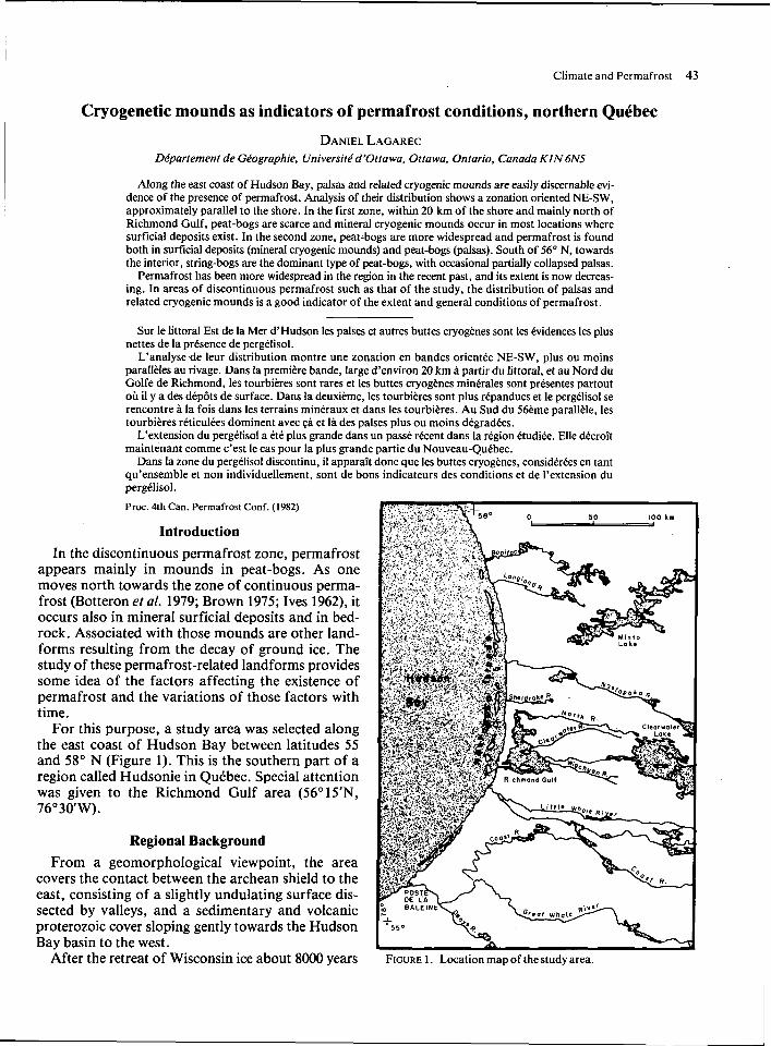
A first type, occurring mainly north of Richmond Gulf in valley bottoms where silty sediments are pres- ent, is the result of dissection of homogeneous flat surfaces by gullies. This isolates linear ridges which then degrade to individual mounds. The regularity of their geometry, their similarity o f dimension and height, the flatness of their tops, and the various stages o f degradation observed in the field suggest that they are the result o f a polygonal, thermal con- traction fracture system, typical of permafrost bodies (Figure 2).
A second type is less widespread and consists of dome-shaped mounds about 20 m in diameter, with
and rims resull from the melt o f ice in the mounds:
gentle slopes, characterized by two sets of cracks, one concentric and one radial. The cracks are interpreted to indicate that the mounds result from the growth of ice-lenses. In most instances these mounds are found downstream of the first type. They indicate forma- tion in the following manner: first, the surface is dis- sected by gullies isolating mounds; and secondly, growth of ice lenses gives them a dome-shape.
Cryogenic Mounds (Palsas) in Peat-bogs Cryogenic mounds may also be found in peat-
bogs. Various.terms have been used in the literature: for example, palsas, minerotrophic palsas, wooded palsas, peat-mounds, peat-plateaus, and palsa- plateaus. Several morphological classifications have been proposed (for example, Schunke 1973). Accord- ing to the classical definition, "the term palsa. . . means a hummock rising out of a bog with a core of ice'' (Seppala 1972). In this study, palsas aredefined as mounds with a perennially frozen core found in peat-bogs. Field investigations in northern Quebec indicate palsas to possess a frozen mineral core con- sisting generally o f either marine silty-clay or till, and a peat cover ranging in thickness from 0 to 2.5 m. Their size is highly variable often reaching several tens of metres in length and heights o f between 2 and I2 m.
The surface cover of palsas changes from south to north. In the southern part, they are usually covered with black spruce trees (Picea mariano) and, as such, are difficult to detect on air photos. These are not in- cluded in the present study. In the northern part, the palsas bear only a lichen mat. In areas inbetween, the palsas commonly have a vegetation of healthy shrubs
Climate and Permafrost 45
I I , , , ,<I > , , l ~ . , , l ~ , ~ , , ,r 1 Wt, , 3 , ,:,,tc,c,,~ ;>,,,:L, I , , , ,,, ;>,,l~,, '-0g5, north <,I K~ihn i rwd C;uII. I I u d v ~ ~ i e , t i t k n 110111 ,111 clei .wm~ of appro\~marcl) ho(1 m abow ground. In the upper part. p:llm are perpendicular to the slope. I n thc lower right palsas areclmc tothe palra-plateau stage.
and lichens with scattered spruce which can be up to 150 years old; the height of dwarf birch (Betulaglan- dulosa) and the form of the spruce trees are good indicators of snow cover thicknesses. In some cases, in winter, the tops of palsas are free of snow or are merely capped by a thin film of ice.
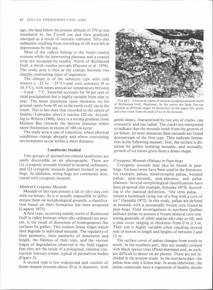
As in the case of mineral mounds, palsas can be found either as isolated landforms or as clusters in peat-bogs, which then display geometrical patterns depending on the shape of the bog, the slope, and the drainage.
In Hudsonie, the most common disposition is an orthogonal pattern with the long axis of the palsas perpendicular to the axis of the cluster and to the slope (Figure 3). In such peat-bogs, several landforms are associated with palsas at different stages of either
I , I i i ' I li'l,(,li .,,I :,.\i 1.1 ;, Ip.'l~.l"l.lil.,'I i l l , / , I 1(111111<,11 Gull :grca, l lud~,mc, r:thcn I nm an ~ l o m ~ m 01 , dppm\~ :n ,$ l~~ l ! 4 M m ahovr ground. The w r i a c e i5 d ~ e c t c d by rough\ ~\olal#ng and small r e d u a l mound,.
ahove ground 0111y mall remn;mt, 01 pal\;!\ and pools are w r - rounded by rims showing their lormer sire.
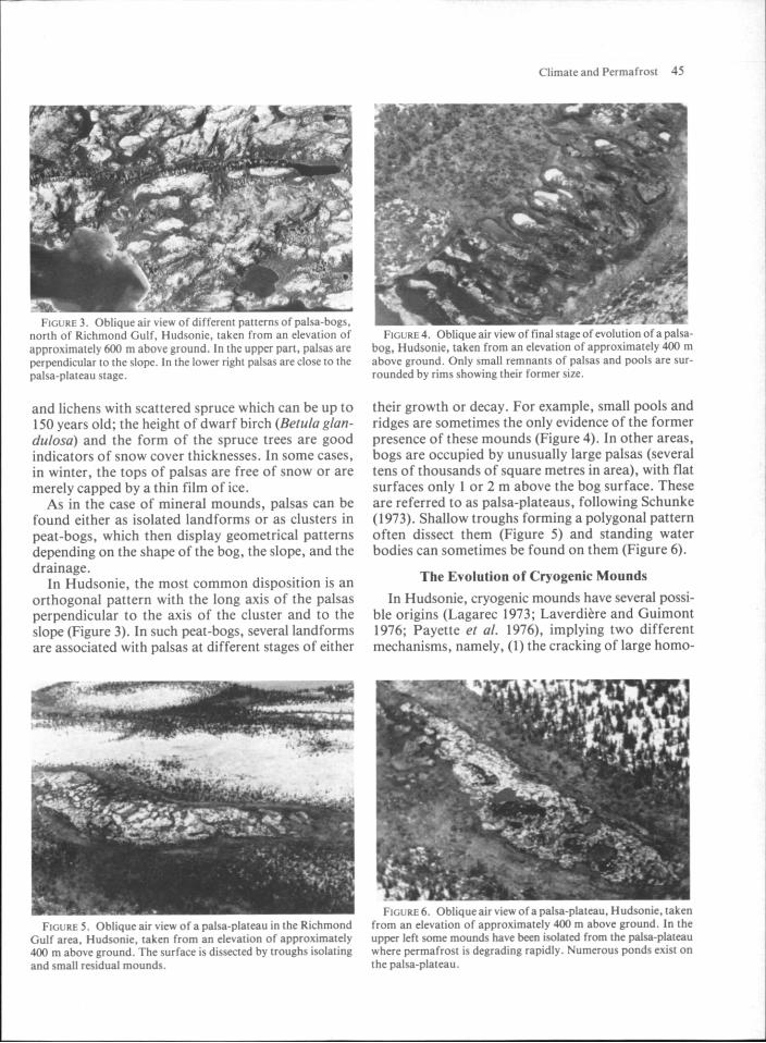
their growth or decay. For example, small pools and ridges are sometimes the only evidence of the former presence of these mounds (Figure 4). In other areas, bogs are occupied by unusually large palsas (several tens of thousands of square metres in area), with flat surfaces only 1 or 2 m above the bog surface. These are referred to as palsa-plateaus, following Schunke (1973). Shallow troughs forming a polygonal pattern often dissect them (Figure 5) and standing water bodies can sometimes be found on them (Figure 6).
The Evolution of Cryogenic Mounds
In Hudsonie, cryogenic mounds have several possi- ble origins (Lagarec 1973; Laverdiere and Guimont 1976; Payette el a/. 1976), implying two different mechanisms, namely, (1) the cracking of large homo-
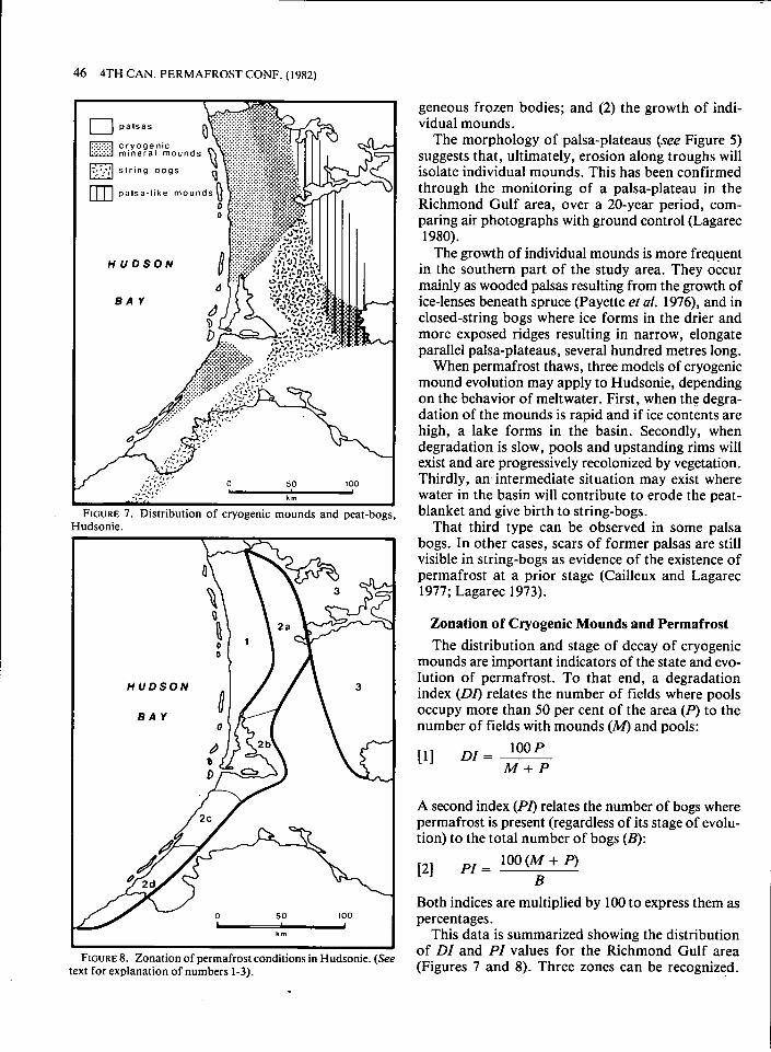
46 4TH CAN. PERMAFROST CONF. (1982)
Hudsonie.
H U D S O N
Zonation of permafrost conditions in Hudsonie. text for explanation of numbers 1-3).
geneous frozen bodies; and (2) the growth of indi- vidual mounds.
The morphology of palsa-plateaus (see Figure 5) suggests that, ultimately, erosion along troughs will isolate individual mounds. This has been confirmed through the monitoring of a palsa-plateau in the Richmond Gulf area, over a 20-year period, com- paring air photographs with ground control (Lagarec 1980).
The growth of individual mounds is more frequent in the southern part of the study area. They occur mainly as wooded palsas resulting from the growth of ice-lenses beneath spruce (Payette et al. 1976), and in closed-string bogs where ice forms in the drier and more exposed ridges resulting in narrow, elongate parallel palsa-plateaus, several hundred metres long.
When permafrost thaws, three models of cryogenic mound evolution may apply to Hudsonie, depending on the behavior of meltwater. First, when the degra- dation of the mounds is rapid and if ice contents are high, a lake forms in the basin. Secondly, when degradation is slow, pools and upstanding rims will exist and are progressively recolonized by vegetation. Thirdly, an intermediate situation may exist where water in the basin will contribute to erode the peat- blanket and give birth to string-bogs.
That third type can be observed in some palsa bogs. In other cases, scars of former palsas are still visible in string-bogs as evidence of the existence of permafrost at a prior stage (Cailleux and Lagarec 1977; Lagarec 1973).
Zonation of Cryogenic Mounds and Permafrost The distribution and stage of decay of cryogenic
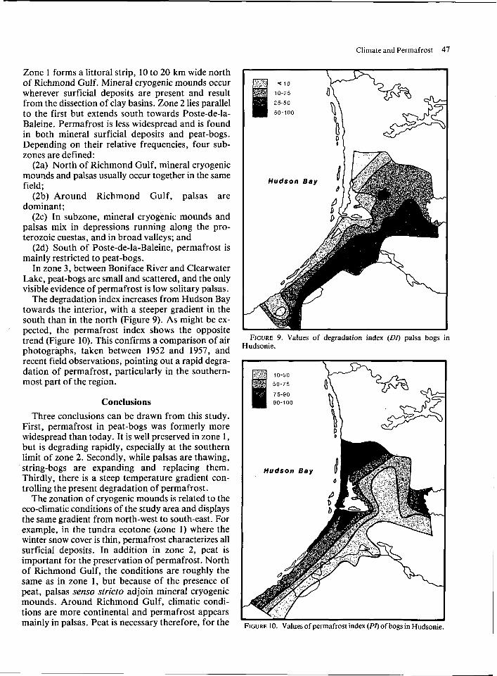
mounds are important indicators of the state and evo- lution of permafrost. To that end, a degradation index (DI) relates the number of fields where pools occupy more than 50 per cent of the area (P) to the number of fields with mounds (M) and pools:
A second index (PI) relates the number of bogs where permafrost is present (regardless of its stage of evolu- tion) to the total number of bogs (B):
Both indices are multiplied by 100 to express them as percentages.
This data is summarized showing the distribution of DZ and PI values for the Richmond Gulf area (Figures 7 and 8). Three zones can be recognized.
Climate and Permafrost 47
Zone 1 forms a littoral strip, 10 to 20 km wide north of Richmond Gulf. Mineral cryogenic mounds occur wherever surficial deposits are present and result from the dissection of clay basins. Zone 2 lies parallel to the first but extends south towards Poste-de-la- Baleine. Permafrost is less widespread and is found in both mineral surficial deposits and peat-bogs. Depending on their relative frequencies, four sub- zones are defined:
(2a) North of Richmond Gulf, mineral cryogenic mounds and palsas usually occur together in the same field;
(2b) Around Richmond Gulf, palsas are dominant;
(2c) In subzone, mineral cryogenic mounds and palsas mix in depressions running along the pro- terozoic cuestas, and in broad valleys; and
(2d) South of Poste-de-la-Baleine, permafrost is mainly restricted to peat-bogs.
In zone 3, between Boniface River and Clearwater Lake, peat-bogs are small and scattered, and the only visible evidence of permafrost is low solitary palsas.
The degradation index increases from Hudson Bay towards the interior, with a steeper gradient in the south than in the north (Figure 9). As might be ex- pected, the permafrost index shows the opposite trend (Figure 10). This confirms a comparison of air photographs, taken between 1952 and 1957, and recent field observations, pointing out a rapid degra- dation of permafrost, particularly in the southern- most part of the region.
Conclusions Three conclusions can be drawn from this study.
First, permafrost in peat-bogs was formerly more widespread than today. It is well preserved in zone 1, but is degrading rapidly, especially at the southern limit of zone 2. Secondly, while palsas are thawing, string-bogs are expanding and replacing them. Thirdly, there is a steep temperature gradient con- trolling the present degradation of permafrost.
The zonation of cryogenic mounds is related to the eco-climatic conditions of the study area and displays the same gradient from north-west to south-east. For example, in the tundra ecotone (zone 1) where the winter snow cover is thin, permafrost characterizes all surficial deposits. In addition in zone 2, peat is important for the preservation of permafrost. North of Richmond Gulf, the conditions are roughly the same as in zone 1, but because of the presence of peat, palsas senso strict0 adjoin mineral cryogenic mounds. Around Richmond Gulf, climatic condi- tions are more continental and permafrost appears mainly in palsas. Peat is necessary therefore, for the
FIGURE 9. Values of degradation index (DO palsa bogs in Hudsonie.
48 4TH CAN. PERMAFROST CONF. (1982)
formation and the preservation of permafrost. Degradation and permafrost indices demonstrate
that the extent of permafrost is decreasing rapidly. Thus, in areas of discontinuous permafrost such as the study area, the distribution of palsas and related cryogenic mounds are good indicators of the extent and general conditions of permafrost.
Acknowledgements This research was made possible by grants from the
National Research Council of Canada and the Minis- tkre de 17~ducation du Quebec to the Centre d7Etudes Nordiques de 17Universite Laval, where the author was then working.
Two anonymous reviewers made fruitful sugges- tions for substantial improvements of the manu- script. Their contribution is greatly appreciated.
References BOTTERON, G., GILBERT, C., LOCAT, C., AND GRAY, J.T. 1979.
Observations preliminaires sur la repartition du pergklisol dans le bassin de la Grande Rivikre de la Baleine. Nouveau-Quebec. GCogr. Phys. et Quaternaire, vol. 33, pp. 291-298.
BROWN, R.J.E. 1975. Permafrost investigations in Quebec and Newfoundland (Labrador). Natl. Res. Counc. Can., Div. Build. Res., Technical Paper 449,39 p.
CA~LLEUX, A. AND LAGAREC, D. 1977. Aspekte des Periglazials in Kanada. Nova Acta Leopold., vol. 47, pp. 9-50.
IVES, J.D. 1962. Iron mining in permafrost central Labrador- Ungava. Geogr. Bull., vol. 197, pp. 66-77.
LAGAREC, D. 1973. Elements de la morphologie cryogkne du Golfe de Richmond, Nouveau-Quebec. Cah. Geogr. Quebec, vol. 17, pp. 465-482.
. 1980. Etude geomorphologique de palses et autres buttes cryogknes en Hudsonie, Nouveau-Quebec. Unpublished Ph.D. thesis, Univ. Laval, Quebec, 308 p.
LAVERDI~RE, C. AND GUIMONT, P. 1976. Les palses de la region de Poste-de-la-Baleine, littoral sud-est de la mer d'Hudson, Nouveau-Quebec. C.R. ACFAS, 43.
PAYETTE, S., SAMSON, H., AND LAGAREC, D. 1976. Theevolution of Permafrost in the Taiga and in the Forest-tundra, Western Quebec-Labrador Peninsula. Can. J. Forest Res., vol. 6, pp. 203-220.
SCHUNKE, E. 1973. Palsen und Kryokarst in Zentral-Island. Akad. des Wissenschaften, Mat.-Phys. Klasse, 4,102 p.
SEPPALA, M. 1972. The term palsa. Z. Geomorphol., N.F. 16, p. 4. WILSON, C. 1969. Climatology of the cold region, Northern Hemi-
sphere 11. Cold Regions Science and Engineering, Monograph 1-A 36, CRREL, Hanover, New Hampshire, 168 p.