Embed Size (px)
Citation preview

Cryospheric Applications of LDCM /
Landsat-8
Ted Scambos
National Snow and Ice Data Center, University of Colorado, Boulder Colorado

Main Goals
Promote use of Landsat-8 by the polar and glacier communities
Acquire data that supports wide range of science applications
Conduct a series of key studies, validate a number of techniques
Demonstrate effectiveness of the Landsat-8 sensors
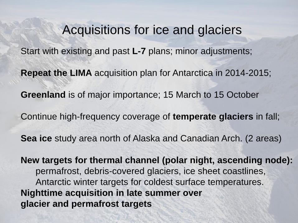
Acquisitions for ice and glaciers
Start with existing and past L-7 plans; minor adjustments;
Repeat the LIMA acquisition plan for Antarctica in 2014-2015;
Greenland is of major importance; 15 March to 15 October
Continue high-frequency coverage of temperate glaciers in fall;
Sea ice study area north of Alaska and Canadian Arch. (2 areas)
New targets for thermal channel (polar night, ascending node):
permafrost, debris-covered glaciers, ice sheet coastlines,
Antarctic winter targets for coldest surface temperatures.
Nighttime acquisition in late summer over
glacier and permafrost targets
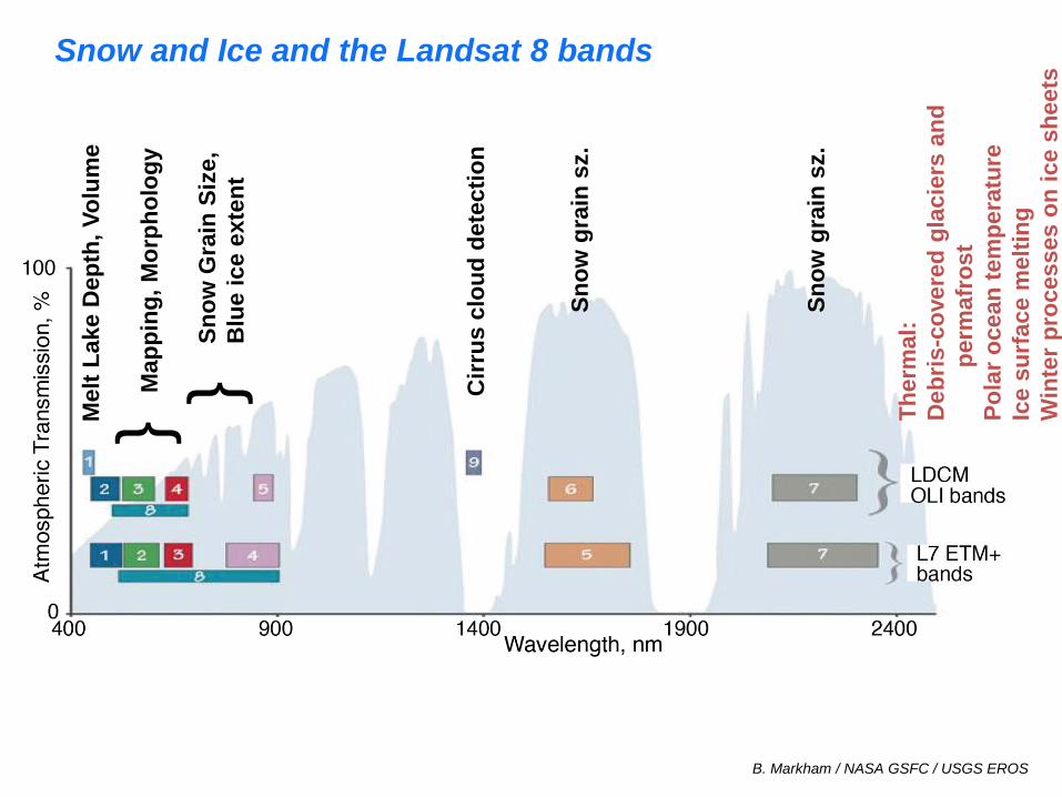
Snow and Ice and the Landsat 8 bands M
elt
Lak
e D
ep
th,
Vo
lum
e
Sn
ow
Gra
in S
ize,
Blu
e i
ce e
xte
nt
} Map
pin
g,
Mo
rph
olo
gy
}
Cir
rus
clo
ud
dete
cti
on
Sn
ow
gra
in s
z.
Sn
ow
gra
in s
z.
B. Markham / NASA GSFC / USGS EROS
Th
erm
al:
Deb
ris
-co
vere
d g
lacie
rs a
nd
p
erm
afr
ost
Po
lar
oce
an
tem
pera
ture
Ice s
urf
ace m
elt
ing
Win
ter
pro
cesses o
n i
ce s
heets

Landsat-8 Ice Sheet Applications
Ice edge, floating ice front extent mapping;
Mapping of ‘grounding line’;
Topography and morphology;
Spectral measurements –
albedo
snow grain size
blue ice extent
melt extent
ice sheet zones (facies)
T. Scambos, T. Haran, NSIDC
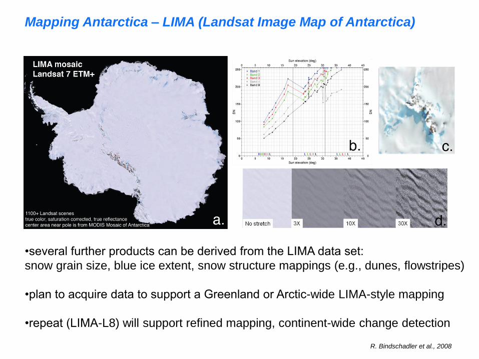
Mapping Antarctica – LIMA (Landsat Image Map of Antarctica)
•several further products can be derived from the LIMA data set:
snow grain size, blue ice extent, snow structure mappings (e.g., dunes, flowstripes)
•plan to acquire data to support a Greenland or Arctic-wide LIMA-style mapping
•repeat (LIMA-L8) will support refined mapping, continent-wide change detection
R. Bindschadler et al., 2008
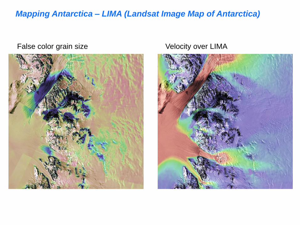
False color grain size Velocity over LIMA
Mapping Antarctica – LIMA (Landsat Image Map of Antarctica)

Melt ponds on ice sheets – area / volume measurements
Effects of melt ponds:
acceleration of flow
enhanced fracturing
Uses new ‘Coastal’ band
-ratio with red or NIR band
Western Greenland,
Antarctic Ice Shelves
Arctic sea ice

Landsat-8 Glacier Applications
polar glaciers
ice front extent, crevasses, ice velocity,
summer melt extent, dust or soot(?)
elevation change
Feature tracking, albedo, ocean therm.
mountain glaciers
Glacier extent beneath debris cover,
ice velocity, equilibrium line altitude,
dust or soot on snow; elevation change
Mapping (w/DEM), thermal data, feat. track.

Older, thicker ice is now gone,
due to drift and melting
J. Maslanik and C. Fowler, CCAR UCB
Landsat-8 and Arctic Sea Ice
•rapid decline due to Arctic warming: sea ice structure, thickness changes
•collect selected area repeatedly to document sea ice type changes, melt ponding
Potential LDCM studies
Snow grain size and blue ice extent on ice sheets from LIMA / MOA
Morphology of ice sheets and ice shelves
(comparison of ‘sensitivity’ to past sensors)
Feature tracking w/ Landsat legacy comparison
Lake extent, depth, and volume in western Greenland / AP
Image differencing and sub-ice-sheet water movement
Photoclinometry / shape-from-shading at grounding line and
interior undulation
Thermal mapping of polar ice sheets, winter inversion layer,
ocean SST at the ice fronts.
LDCM / Landsat-8 Cryosphere group
• Ted Scambos (PI) is a Senior Research Scientist, and Lead Scientist
at NSIDC, a part of University of Colorado; ice sheet mapping, polar field
geophysics, climate change in polar regions, sea ice processes
• Robert Bindschadler (Co-I, contractor) is an emeritus scientist for
NASA affiliated with the Cryospheric Sciences group at GSFC
• Terry Haran, senior programmer and geospatial mapping expert, NSIDC
• Jennifer Bohlander,data analysis and image processing, NSIDC
• Patricia Vornberger, data processing, GSFC contracting firm
• Allen Pope, spectral mapping of mountain glaciers; polar remote sensing;
will be a post-doc at NSIDC, Fall 2013

Questions?