Embed Size (px)
Citation preview

CSC-001
Company: The United Illuminating Company Witness: Matt Cloud Ronald Rossetti Docket No. CSC Petition No. 1120 Page 1 of 1 Date Submitted: December 30, 2014 CSC-001 Q: What is the purpose of the proposed gravel area along the northeast side of the property?
If it is for equipment storage, what type of equipment would be placed there and for what duration? Will the installation of the proposed gravel area require the removal and or/trimming of existing trees?
CSC-001 A: The gravel area on the northeast side of the property provides a maneuvering area
for United Illuminating’s mobile transformer. This mobile transformer is utilized in emergency situations following a failure of a station power transformer to restore the substation to normal operation. The mobile transformer is not stored on the property and is brought to this substation from a remote storage location. The gravel area allows for the required turning maneuvers to position the 90 foot long mobile transformer directly across from the 24 foot double swing drive gate. The mobile transformer can then be reversed into the substation yard and connected to the 115kV connection points. This maneuver requires the removal of one tree in the center of the gravel area. The removal of this one tree allows sufficient maneuvering room for the mobile transformer without the need to remove or trim neighboring trees.

CSC-002
Company: The United Illuminating Company Witness: Shawn Crosbie Docket No. CSC Petition No. 1120 Page 1 of 1 Date Submitted: December 30, 2014 CSC-002 Q: Please provide a copy of the environmental report prepared for the petition
(described in the Town of Fairfield’s letter of December 5, 2014). CSC-002 A: The Town of Fairfield letter (dated 12/5/2014) refers to a “12-page environmental
report.” The Company assumes the Town is referring to the Company’s petition that was filed with the Council since that document is 12 pages long. No other environmental report previously has been filed by the Company. A copy of the Wetland Identification and Delineation Report is being provided in response to interrogatory CSC-004. Refer to attachment A, Wetland Identification and Delineation Report.

CSC-003
Company: The United Illuminating Company Witness: Shawn Crosbie Docket No. CSC Petition No. 1120 Page 1 of 1 Date Submitted: December 30, 2014 CSC-003 Q: Was a Natural Diversity Database Request to the CT DEEP performed? Please
submit supporting documentation. CSC-003 A: Yes, a National Diversity Database request was submitted to the CT DEEP. A
response was received from CT DEEP on 11/14/2014. Refer to attachment B, Stormwater Discharge Permit for the Hawthorne Substation Located at 180 Hawthorne Drive in Fairfield, Connecticut.

CSC-004
Company: The United Illuminating Company Witness: Shawn Crosbie Docket No. CSC Petition No. 1120 Page 1 of 1 Date Submitted: December 30, 2014 CSC-004 Q: Was a wetland survey conducted for the project? If so, please submit. If not, why
not? CSC-004 A: Yes a wetlands survey was performed on 9/5/2014. Refer attachment A, Wetland
Identification and Delineation Report.

CSC-005
Company: The United Illuminating Company Witness: Shawn Crosbie Docket No. CSC Petition No. 1120 Page 1 of 1 Date Submitted: December 30, 2014 CSC-005 Q: Please describe stormwater control features that are protective of adjacent
properties and wetlands/watercourses. CSC-005 A: The following stormwater control features will be used during construction:
• Silt Fence • Erosion Control Blankets • Hay Bales • Diversion Swales • Restoration (Seeding and Mulch)
Refer to attachment C, Stormwater Pollution Control Plan Site Plan.

CSC-006
Company: The United Illuminating Company Witness: Matthew Cloud Ronald Rossetti Docket No. CSC Petition No. 1120 Page 1 of 1 Date Submitted: December 30, 2014 CSC-006 Q: Can evergreens for visual screening be installed along any portion of the proposed
south fence line? CSC-006 A: With the appropriate approvals from CL&P, UI can place screening shrubs along
the southern fence line. The screening shrubs must have a maximum mature height of 15 feet. Rhododendrons are recommended as their maximum mature height meets the previously stated requirements and have some resistance to deer. If CL&P approves the placement of shrubs, UI reserves the right to trim the screening as needed to maintain the required clearances and security setback from the southern fence line. Screening would require the purchase and installation of infrared security cameras along the south fence line, due to the added security risk of low visibility, to provide 100% coverage of the perimeter. Current design includes standard video cameras for required security coverage. Refer to attachment D, Site Plan.

CSC-007
Company: The United Illuminating Company Witness: Matt Cloud Ronald Rossetti Docket No. CSC Petition No. 1120 Page 1 of 1 Date Submitted: December 30, 2014 CSC-007 Q: The diagram in the petition shows a fence gate along the west fence line. Is access
to the substation proposed from this side? If so, please provide details of the access road.
CSC-007 A: The drive gate on the western fence line will not be used for access to the
substation and no access road is planned for construction. The gate is there to allow for United Illuminating personnel to access the western area of the property for regular maintenance practices such as landscaping, fence maintenance and erosion control/monitoring around the western fenced perimeter.

CSC-008
Company: The United Illuminating Company Witness: Matthew Cloud Ronald Rossetti Docket No. CSC Petition No. 1120 Page 1 of 1 Date Submitted: December 30, 2014 CSC-008 Q: Please submit a site plan for the project that depicts the following:
a. Site clearing; b. Site grading; c. Distance to nearest wetlands; d. Distance to nearest residence; e. Fencing and component layout; f. Landscaping; and g. Drainage control features.
CSC-008 A: Refer to attachment D, Site Plan.

CSC-009
Company: The United Illuminating Company Witness: Matthew Cloud Ronald Rossetti Docket No. CSC Petition No. 1120 Page 1 of 3 Date Submitted: December 30, 2014 CSC-009a Q: Can the west and south fence lines be moved in, so that the outer lightning
masts are out of the compound? CSC-009a A: The IEEE Std. C2 National Electrical Safety Code requires a minimum of 13
feet from live parts to the substation fence. The current UI standard substation design criteria requires a minimum of 20 feet between live parts and the substation fence to allow for drive access and turn radius. Moving the west and south fence lines inside the lightning masts would violate UI substation design criteria and best practices with regards to safety and security.

CSC-009
Company: The United Illuminating Company Witness: Matthew Cloud Ronald Rossetti Docket No. CSC Petition No. 1120 Page 2 of 3 Date Submitted: December 30, 2014 CSC-009b Q: Why does the east fence line have an irregular shape? Can a straight fence line
be installed? CSC-009b A: The irregular shape is to accommodate the angled drive for the UI mobile
transformer to back into its emergency position. A straight fence could be accomplished by moving the south section to the east, however, this was not originally designed so to reduce cost for grading, grounding and site preparation, as well as maintain UI’s best practices with regards to safety and security.

CSC-009
Company: The United Illuminating Company Witness: Matthew Cloud Ronald Rossetti Docket No. CSC Petition No. 1120 Page 3 of 3 Date Submitted: December 30, 2014 CSC-009c Q: The south side of the compound has square corners, can angled corners be used
instead? CSC-009c A: UI can angle the corners of the southern fence line. However, this will limit
access to the southeastern corner and require UI to relocate the affected lightning mast. To include an angled fence in the 100% view coverage areas, the purchase and installation of additional security cameras is required.
CSC-009
Company: The United Illuminating Company Witness: Matthew Cloud Shawn Crosbie Docket No. CSC Petition No. 1120 Page 1 of 1 Date Submitted: December 30, 2014 CSC-009d Q: What happens to the abandoned well? CSC-009d A: The current well located on the property will be removed and filled per the state
and local well-drilling code requirements for well abandonment during the capacitor bank project. The well is physically located in a pit with raised masonry sides, covered with a locked, non-vented Bilco-type door. The casing is capped and both the supply line and the electric service to the submersible pump have been disconnected and terminated inside the bathroom at the center rear of the building. Refer to attachment E, Aquarion Well Abandonment Agreement, submitted as required by the Aquarion Water Company as a condition precedent to activating the water service to Hawthorne Drive.

Wetland Identification and Delineation Report
Hawthorne Capacitor Bank Addition Project
Fairfield, Connecticut
BL Project No.: 14S2153
Prepared for
Black & Veatch 11401 Lamar Avenue
Overland Park, KS 66211
Prepared by
BL Companies, Inc. 355 Research Parkway
Meriden, CT 06450
September 10, 2014
Company: The United Illuminating Company Docket No. Petition No. 1120 Date Submitted: December 30, 2014
CSC-002 & CSC-004 Attachment A
Witness: Shawn Crosbie
1

Wetland Identification and Delineation Report
Hawthorne Capacitor Bank Addition Project
TABLE OF CONTENTS
Page
I. Introduction ................................................................................................................... 1 II. Methodology…………………………………………………………………………………….2
III. Regulatory Information…………………………………………………………………………2 IV. Site Investigation……………………………………………………………………………..... 3
V. Resource Descriptions .................................................................................................. 3 VI. Summary ................................................................................................................ ……4 VII. Preparer ........................................................................................................................ 5 Figures Site Location Map ............................................................................................................ 1 Appendices
A. Photographs B. Wetland Location Mapping C. Resource Mapping
Company: The United Illuminating Company Docket No. Petition No. 1120 Date Submitted: December 30, 2014
CSC-002 & CSC-004 Attachment A
Witness: Shawn Crosbie
2
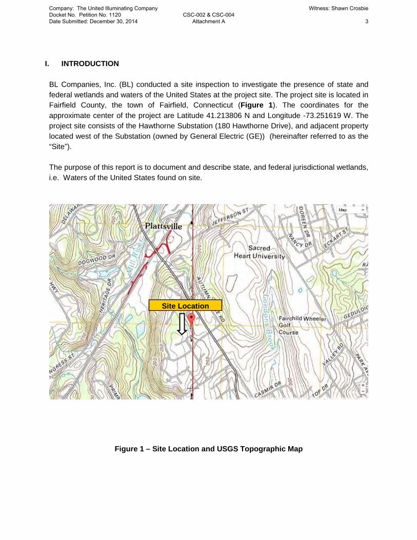
I. INTRODUCTION BL Companies, Inc. (BL) conducted a site inspection to investigate the presence of state and federal wetlands and waters of the United States at the project site. The project site is located in Fairfield County, the town of Fairfield, Connecticut (Figure 1). The coordinates for the approximate center of the project are Latitude 41.213806 N and Longitude -73.251619 W. The project site consists of the Hawthorne Substation (180 Hawthorne Drive), and adjacent property located west of the Substation (owned by General Electric (GE)) (hereinafter referred to as the “Site”). The purpose of this report is to document and describe state, and federal jurisdictional wetlands, i.e. Waters of the United States found on site.
Figure 1 – Site Location and USGS Topographic Map
Site Location
Company: The United Illuminating Company Docket No. Petition No. 1120 Date Submitted: December 30, 2014
CSC-002 & CSC-004 Attachment A
Witness: Shawn Crosbie
3

II. METHODOLOGY
This investigation involved a wetland/watercourse delineation that was completed by a wetland scientist and qualified soil scientist and conducted in accordance with the principles and practices noted in the United States Department of Agriculture (USDA) Soil Survey Manual (1993). The soil classification system of the National Cooperative Soil Survey was used in this investigation to identify the soil map units present on the project site. Vegetation, soils, and hydrology were observed and documented during the site investigation in order to meet the criteria of state and federal delineation methodologies. Soil types were identified by observing soil morphology (soil texture, color, structure, etc.). To observe the morphology of the soils, numerous test pits and/or hand borings (generally to a depth of at least two feet) are completed. If wetland and/or watercourses were determined to be present, their boundaries were identified with flags and hung from vegetation or small wood stakes. These flags are labeled “Wetland Boundary” and are generally spaced a maximum of approximately 50 feet apart. It is important to note that flagged wetland and watercourse boundaries are subject to verification by regulatory agencies.
III. REGULATORY INFORMATION Wetlands and watercourses are regulated by state, municipal and federal laws and regulations, each with different definitions and regulatory requirements. Accordingly, the State and municipalities may regulate wetland and waters that fall outside of federal jurisdiction; however, where federal jurisdiction exists, concurrent State and municipal jurisdiction is almost always present. State/Municipal Jurisdiction State of Connecticut wetland determinations are based on the presence of poorly drained, very poorly drained, alluvial, or floodplain soils and submerged land. Watercourses are defined as “rivers, streams, brooks, waterways, lakes, ponds, marshes, swamps, bogs and all other bodies of water, natural or artificial, vernal or intermittent, public or private, which are contained within, flow through or border upon the state or any portion thereof.” Intermittent watercourse determinations are made based on the presence of a defined permanent channel and bank, and two of the following characteristics: (1) evidence of scour or deposits of recent alluvium or detritus, (2) the presence of standing or flowing water for duration longer than a particular storm incident, and (3) the presence of hydrophytic vegetation. (See Inland Wetlands and Watercourses Act §22a-38 CGS.)
Company: The United Illuminating Company Docket No. Petition No. 1120 Date Submitted: December 30, 2014
CSC-002 & CSC-004 Attachment A
Witness: Shawn Crosbie
4

Federal Jurisdiction Jurisdictional wetlands at the Federal level consist of “waters of the United States”, which includes lakes, rivers and streams, as well as vegetated wetlands (See 33 CFR 328.8). The onsite waters and wetlands, regulated by the U.S. Army Corps of Engineers (ACOE), were delineated in accordance with the Regional Supplement to the Corps of Engineers Wetland Delineation Manual Northcentral and Northeast Region (Version 2.0) (January 2012). This Manual requires there to be dominant hydrophytic vegetation, hydric soils, and hydrological conditions present in determining wetland areas. Project Study Area The project site is located within a residential neighborhood, along a minor urban roadway with historical land use in the form of farming activities. The site lies within the Mill River River drainage basin (7108), part of the Southwest Eastern Regional complex and is not located within a public water supply watershed. According to the Federal Emergency Management Agency’s (FEMA) Flood Insurance Rate Map number 09001C0409F for Fairfield County, Connecticut, effective date June 18, 2010 (See Appendix C), no mapped floodplain areas are located on the Site.
IV. SITE INVESTIGATION The project Site was investigated on September 05, 2014, with a temperature in the high-70’s 0F under sunny conditions. Field investigations focused on wetlands within 180 Hawthorne Drive, property acquisition area and property adjacent to both areas. Data on the current plant communities, soils, and hydrology were documented to support the wetland delineation. Descriptions of resources are provided in Section V. Photographs of the identified wetland resources, taken to provide visual documentation of the area, are located in Appendix A. The location of the data points are identified on the wetland mapping located in Appendix B. Resource Mapping, including the FEMA mapping, Natural Resources Conservation Services soil survey data and National Wetland Inventory are located in Appendix C.
V. RESOURCE DESCRIPTIONS Wetlands and watercourses were not identified on the Hawthorne Substation parcel nor within the property acquisition area, west of the Substation. An isolated non-vegetated concave depression wetland was identified north of 180 Hawthorne Drive on the GE Property, outside of the project Site (See Appendix B, Wetland Location Mapping). The wetland is classified as a palustrine forested broad leaved deciduous (USFW Classification: PFO1). The dominant vegetation is Red maple (Acer rubrum) which borders the wetland edge. The center and majority of the wetland is non-vegetated. Hydric soil characteristics observed includes low chroma and prominent redoximorphic concentrations throughout the horizons. Wetland hydrologic characteristics include; sparsely vegetated concave surface, presence of reduced iron, water stained leaves, geomorphic position, surface soil cracks, and microtopographic relief.
Company: The United Illuminating Company Docket No. Petition No. 1120 Date Submitted: December 30, 2014
CSC-002 & CSC-004 Attachment A
Witness: Shawn Crosbie
5

The south side of the wetland was flagged using consecutive numbers 01 through 05 to provide a location of the wetland at the closest boundary edge This wetland is located outside of the project Site and was identified to ensure proper sediment and erosion controls be implemented if any earth moving or construction activities proceed within the Site boundaries. As this wetland is isolated, there is potential it acts as breeding habitat for amphibians during the spring seasons. Soils: The soil series identified on the Site property consists of Udorthents-Urban Land Complex (306). Udorthents smoothed (variable fill material) This unit consists of areas that have been altered by cutting or filling. Slopes are mainly 0 to 25 percent. The material in these areas is mostly loamy, and in the filled areas it is more than 20 inches thick. Some of the filled areas are on flood plains, in tidal marshes, and on areas of poorly drained and very poorly drained soils. Included with this unit in mapping are small areas of soils that have not been cut or filled. Also included are a few larger urbanized areas and a few small areas containing material such as logs, tree stumps, concrete, and industrial wastes. A few areas have exposed bedrock. Included areas make up about 30 percent of this map unit. The properties and characteristics of this unit are variable, and the unit requires onsite investigation and evaluation for most uses. This unit is not assigned to a capability subclass. Ur—Urban land This unit consists of areas where urban structures cover more than 85 percent of the surface. Examples of such structures are roads, parking lots, shopping and business centers, and industrial parks. Most areas are in the towns of Bridgeport, Danbury, Fairfield, Norwalk, Shelton, Stamford, and Stratford. The areas are commonly rectangular and range from 5 to 500 acres. Slopes range from 0 to 8 percent but are dominantly less than 5 percent. Included with this unit in mapping are small areas of Udorthents and areas of excessively drained Hinckley soils; somewhat excessively drained Hollis soils; well drained Agawam, Charlton, and Paxton soils; and moderately well drained Ninigret and Sutton soils. Included areas make up about 15 percent of this map unit. This unit requires onsite investigation and evaluation for most uses.
VI. SUMMARY BL Companies identified one (1) regulated and jurisdictional freshwater inland wetland area north of the Hawthorne Substation located outside of the Site boundaries. Poorly drained soils, hydric soils, hydrophytic vegetation, and hydrology were all observed in the wetland location satisfying the criteria of the State and Federal USACOE methodology for wetland delineations.
Company: The United Illuminating Company Docket No. Petition No. 1120 Date Submitted: December 30, 2014
CSC-002 & CSC-004 Attachment A
Witness: Shawn Crosbie
6

VII. PREPARER Raina Huebner Ms. Huebner holds a Master’s Degree in Wetland, Watercourse, Ecosystem Management and Soil Science. Ms. Huebner has been delineating federal and state wetlands for the past 4 years. In addition, Ms. Huebner has acted as lead wetland scientist and conducted many function value impact assessments throughout New England, New York, New Jersey, Pennsylvania and Ohio. Ms. Huebner received a Certificate of Army Corps Wetland Delineation Training (Institute for Wetland Education and Environmental Research), holds a Wetland Professional in Training certification and is a qualified Soil Scientist. REFERENCES 1. Brinson, M.M. 1993. A Hydrogeomorphic Classification for Wetlands. Tech. Rpt.WRP-DE-
4, U.S. Army Engineer Waterways Experiment Station, Vicksburg, MS.
2. Cowardin, L.M., V. Carter, F.C. Golet and E.T. LaRoe, 1979. Classification of Wetlands and Deepwater Habitats of the United States. U.S. Fish and Wildlife Service. Washington, D.C. FWS/OBS-79/31.
3. United States Department of Agriculture (USDA) Natural Resources Conservation Service
(NRCS) soil descriptions. Internet site: (http://soils.usda.gov/technical/classification/osd/index.html)
4. Environmental Laboratory, 1987. Corps of Engineers Wetland Delineation Manual. Technical Report Y-87-1. US Army Engineer Waterways Experiment Station. Vicksburg, Miss.
5. Lichvar, R.W. 2012 The National Wetland Plant List; 2013 wetland ratings, Phytoneuron
2013-49; 1-241. http://wetland_plants.usace.army.mil/ Cold Regions Research and Engineering Laboratory, US Army Corps of Engineers.
6. United States Army Corps of Engineers. January 2012. Regional Supplement to the Corps
of Engineers Wetland Delineation Manual: Northcentral and Northeast Region (Version 2.0). Ed. J.S. Wakely, R.W. Lichvar, C.V. Noble, and J.F. Berkowitz. ERDC/EL TR-12-1. Vicksburg, MS: U.S. Army Research and Development Center.
Company: The United Illuminating Company Docket No. Petition No. 1120 Date Submitted: December 30, 2014
CSC-002 & CSC-004 Attachment A
Witness: Shawn Crosbie
7

APPENDIX A
Company: The United Illuminating Company Docket No. Petition No. 1120 Date Submitted: December 30, 2014
CSC-002 & CSC-004 Attachment A
Witness: Shawn Crosbie
8

PLATE 1
PHOTO 1: View of wetland 1 looking West
PHOTO 2: View of wetland 1 looking south west
Hawthorne Capacitor Bank Addition Project 14S2153
Company: The United Illuminating Company Docket No. Petition No. 1120 Date Submitted: December 30, 2014
CSC-002 & CSC-004 Attachment A
Witness: Shawn Crosbie
9

APPENDIX B
Company: The United Illuminating Company Docket No. Petition No. 1120 Date Submitted: December 30, 2014
CSC-002 & CSC-004 Attachment A
Witness: Shawn Crosbie
10

Company: The United Illuminating Company Docket No. Petition No. 1120 Date Submitted: December 30, 2014
CSC-002 & CSC-004 Attachment A
Witness: Shawn Crosbie
11

APPENDIX C
Company: The United Illuminating Company Docket No. Petition No. 1120 Date Submitted: December 30, 2014
CSC-002 & CSC-004 Attachment A
Witness: Shawn Crosbie
12

Sep 4, 2014
This map is for general reference only. The US Fish and Wildlife Service is notresponsible for the accuracy or currentness of the base data shown on this map. Allwetlands related data should be used in accordance with the layer metadata found onthe Wetlands Mapper web site.
User Remarks:
Company: The United Illuminating Company Docket No. Petition No. 1120 Date Submitted: December 30, 2014
CSC-002 & CSC-004 Attachment A
Witness: Shawn Crosbie
13

Fairfield
Westport
Easton
Weston
Bridgeport
Trumbull
Westport
I 95
Merritt Pkwy
Park Ave
State Hwy 15
Stat
e H
wy
136
Burr St
Stat
e H
wy
58
Redding Rd
Black Rock Tpke
Black Rock Rd
Cross Hwy
State Hwy 59
Madison Ave
Wes
tpor
t Rd
North Ave
Benson Rd
Sturges Hwy
State St
Bayberry Ln
Boston Post Rd
East
on R
d
Old Town Rd
Bronson Rd
Weston Rd
Hillside Rd
Good Hill Rd
Stat
e H
wy
8
Stat
e H
wy
57
Morehouse Hwy
Greens Farms Rd
Stat
e H
wy
25
Lyon
s Pl
ain
Rd
Mai
n S
t
Mill P
lain Rd
Post Rd
Reservoir A
veMorehouse Rd
Merwins Ln
Congress S
tW
ilson Rd
Stratfield Rd
Hills
poin
t Rd
North St
Sport Hill Rd
Beer
s Rd
State Hw
y 33
Capitol Ave
State Hw
y 135
Norman St
Stee
p H
ill R
d
Maple Ave
Long Lots Rd
Reef Rd
Iranistan Ave
Laurel Ave
Mill Hill T
er
Melville Ave
Platt St
Pequo
t Ave
Merritt St
Hulls H
wy
Railroad Ave
Roseville Rd
Wilton R
d
Wood Ave
Carrie Ln
Davis H
ill Rd
Jennings Rd
Stillso
n Rd
Pine Creek R
d
Will
iam
St
Edison
Rd
VL F
orge
Rd
Catamou
nt Rd
Lindley St
Clark St
Compo Rd
Wayne S
t
Round Hill Rd
Old Redding Rd
Rive
rsid
e Av
e
Atlantic St
Impe
rial A
ve
South
Ave
Banks R
d
Fairfi
eld B
each
Rd
Wes
tpor
t Tpk
eMine Hill Rd
Oldfield R
d
Mile Cm
n
River Rd
Howard Ave
Gra
nd S
t
Sylv
an A
ve
Harbor
Rd
Villa Ave
Route 127
Bulkley Ave
Beach Rd
Hulls F
arm R
d
John St
Hillandale Rd
King
s Hwy
Norton Rd
Commerce Dr
Pine St
Reid St
Gilm
an St
Valley
Rd
Rou
te 1
11
Sasco Hill R
d
Fairfield
Woods
Rd
Judd St
Church Hill Rd
Morningside D
r
Lords Hwy
Mill H
ill Rd
Clinton Ave
Wells Hill Rd
11 O Clock Rd
Knap
ps H
wy
State Street E
xt
Galloping Hill Rd
Joan Dr
Burr
ough
s R
d
Lincoln Ave
Barnum Blvd
Clapboard Hill Rd
Housatonic Ave
Gro
vers
Ave
Dew
ey S
t
Center St
Brewster St
Frenchtown R
d
Old Po
st Rd
Ellsworth St
Jewett Ave
Coleytown Rd
Sturges Rd
Sherwood I C
onnector
Old Easton Tpke
Arden Rd
Rowland Rd
Cob Dr
Hill Farm
RdMorehouse Ln
Trumbull Ave
Tahm
ore
Dr
Lafayette St
Duck Farm Rd
Tersana Dr
Fairview Ave
Wood Dr
Har
ral A
ve
Treadwell Ln
Penfield Rd
Banks North R
d
Indian AvePolk S
t
Hoydens Ln
Kato
na D
r
Know
lton
St
Old Rd
Alba Ave
Ford Rd
Map
le L
n
Bostwick A
ve
Jefferson St
Laur
el Dr
Coley D
r
Adle
y R
d
Davis
Rd
Riversi
de Dr
Kettle Creek R
d
Fanton Hill Rd
Surrey Ln
Old Dam Rd
Delaware Rd
Anton St
Sunset Dr
River St
Tuckahoe Rd
Plattsville Rd
Parish Rd
Bridge St
Soundview Dr
Hoydens H
ill Rd
Jennie Ln
Summit St
Hawley Ave
Water S
t
Corn
ell R
d
Oak St
Vincellette St
Gilbert H
wy
US Hwy 1
Garden St
Riv
er L
n
Farrell Rd
Sunset Rd
Pitt St
Castle
Ave
Rua
ne S
t
Exeter St
Charle
s St
Sprin
ger R
d
Robin St
Park
Ln
Silver Spring Rd
Hancock Ave
Greenfi
eld D
r
Codfish Ln
White Birch Rd
Eckart St
Fence Row Dr
Prospect Rd
Salem Rd
Cherry St
Longshore Rd
Sky Top D
r
Hales Rd
Aran Hill Rd
Silent Grv
Mills
Ln
Eliot
St
Hemlock Rd
Brett Rd
Broo
klaw
n A
ve
Woody Ln
Nepas
Rd
Meeke
r Rd
October H
l
Pond
Rd
Mel
ville
Dr
Dunham Rd
Comm
on Rd
Cedar Rd
Hyde Ln
Gate Ridge Rd
Snowflake Ln
Nob
le A
ve
Miro St
Toilso
me Hill Rd
Wellington Dr Berk
ley
Rd
Woodside Ave
Bartling Dr
Eames Blvd
Ellery Ln
Carroll Rd
Toll H
ouse
Ln
Moffitt St
Flintlock Rd
Colony AveFreeborn Rd
Butto
nbal
l Ln
Har
vest
er R
d
West Ave
Jackman Ave
Acorn Ln
Shrub Oak Ln
Pert St
Hanover St
Fox StKing St
Willo
w S
t
West Rd
Riders LnO
ld Mill Rd
Elm St
Herbert Baldwin Ln
South St
Web
b Rd
Myrtle Ave
Primrose Ln
Greenfield Hill Rd
Steiner St
Wyld W
ood Rd
Glendale Ave
Plum Tree Ln
Parking Lot
Buck
Hill
Rd
Agawam Ave
Kings Dr
Ridge Rd
Governors Ln
Sasco Pt
Harmony St
Fern
Val
ley
Rd
School Rd
Tesiny Ave
Abbotts Ln
Linda Ln
Fair Oak Dr
Parkwood Rd
Laurel Lk
Hunyadi Ave
Linden Ave
Fisk
e Av
e
Pumpkin Hill Rd
Arlen R
d
Gault Ave
Geduldig St
Harvest Moon Rd
Tubbs Spring Dr
Oxbrook Rd
Ferncliff Rd
Fleming Ln
Washington Ave
Sachem Rd
Coventry Ln
Free
born
Wal
k Tr
l
Avalon
Gate
s
Fallowfield Rd
Brion Dr
Grove Pt
Glendin
ning P
l
Greenbrier Rd
Wils
on S
t
Bassick Rd
Elberta Ave
Sturges Cmn
Fran
cis
St
Daniel Ct
Forest Dr
Mayflower Pkwy
Ocean Ter
Koger Rd
Colony St
Wendy Rd
Broad St
Jesup RdWright St
Oxford R
dHansen Ave
Ivy Ter
Daybreak Ln
Cha
tfiel
d D
r
Tupelo Rd
Leighton Rd
Gle
nwoo
d Av
e
Mallard Ln
Jone
s Av
e
Foggwood Rd
Jesse Lee Dr
Burr Rd
Stonybrook Rd
Front St
Brianna Ln
French St
Baker Ave
Thomas Rd
Hackberry H
ill Rd
Grays Farm
Rd
Windsor R
d
Woodhill Rd
Ferry Ln
Midlock Rd
Wat
ersi
de T
er
Tully Dr
Kaechele Pl
Pent Rd
Hickory Dr
Saw
Mill
Rd
Riverfield Dr
Indian Field Rd
Hickory Ln
Oakview
Dr
Service Road
Fensky Rd
Dudley Dr
Perth S
t
Szost
Dr
Frank St
Walker Ln
Calumet Ln
Old Farm Rd
Cardinal LnTerhune D
r
Gorham Pl
Taintor D
r
Blue
wat
er H
l
Treasure Rd
Brookside Dr
Taylor Pl
Ronald Dr
Twin Walls Ln
Old
Bar
n R
d
Longview Ave
College Pl
Pine
Tre
e Dr
Mill St
Summit L
n
Mill Hill L
n
New St
Ridge A
ve
Bury
ing
Hill R
d
Henderson Rd
Field Rock Rd
Jana
Dr
Hollin C
t
Waller Rd
Deepwood Rd
Compo Mill Cv
Ross Hill Rd
Red Oak Rd
Stel
la L
n
Lake
view
Ave
Tang
lewo
od R
d
Elliot Ln
Rhoda Ave
Stuart Pl
Bick Ter
Coach Ln
Godfrey Ln
Brightfield Ln
Pine
Poi
nt D
r
Ston
ewal
l Ln
Birch St
Jenn
ie Ln
Com
po R
d
North S
t
I 95
Brooksid
e Dr
Freeborn Rd
Acorn Ln
Merrit
t Pkw
y
Stat
e Hw
y 15
Myrtle Ave
North Ave
Con
gres
s St
Valle
y Rd
Clinton Ave
Exit 19
Exit 25
Exit 44
Exit 1
Exit 47Exit 48
Exit 18
Exit 21
Exit 24
Exit 5
Exit 22
Exit 26
Exit 4
Exit 42
Exit 23
Exit 20
Exit 8
Exit 46
Exit 2
Exit 19
§̈¦95
£¤1
SV136
SV15
SV58
SV25
SV135
SV57
SV33
SV59
SV111Natural Diversity Data Base
June 2014
Areas
NOTE: This map shows general locationsof State and Federal Listed Species and Significant Natural Communities. Informationon listed species is collected and compiledby the Natural Diversity Data Base (NDDB) from a number of data sources . Exact locations of species have been buffered to produce the general locations. Exact locations of species and communities occur somewhere in the shaded areas, not necessarily in the center. A new mapping format is being employedthat more accurately models important riparian and aquatic areas and eliminates the need for the upstream/downstream searches required in previous versions.
This map is intended for use as a preliminary screening tool for conducting aNatural Diversity Data Base Review Request.To use the map, locate the project boundariesand any additional affected areas. If theproject is within a shaded area there may be a potential conflict with a listed species. For more information, complete a Request for Natural Diversity Data Base State Listed Species Review form (DEP-APP-007), and submit it to the NDDB along with the required maps and information. More detailed instructions are provided with the request form on our website.
www.ct.gov/deep/nddbrequest
This file has PDF Layers. Look for the Layerstab on the left. Expand the layers and usethe "eye" icons to change visibility.
QUESTIONS: Department of Energy and Environmental Protection (DEEP)79 Elm St., Hartford CT 06106Phone (860) 424-3011
FAIRFIELD, CT
0 10.5Miles ±
Town Boundary
State and Federal Listed Species & Significant Natural Communities
Company: The United Illuminating Company Docket No. Petition No. 1120 Date Submitted: December 30, 2014
CSC-002 & CSC-004 Attachment A
Witness: Shawn Crosbie
14

Company: The United Illuminating Company Docket No. Petition No. 1120 Date Submitted: December 30, 2014
CSC-002 & CSC-004 Attachment A
Witness: Shawn Crosbie
15

Soil Map—State of Connecticut
Natural ResourcesConservation Service
Web Soil SurveyNational Cooperative Soil Survey
9/4/2014Page 1 of 3
4563
780
4563
830
4563
880
4563
930
4563
980
4564
030
4564
080
4564
130
4564
180
4563
830
4563
880
4563
930
4563
980
4564
030
4564
080
4564
130
4564
180
646440 646490 646540 646590 646640 646690
646440 646490 646540 646590 646640 646690
41° 12' 56'' N73
° 1
5' 1
2'' W
41° 12' 56'' N
73° 1
4' 5
9'' W
41° 12' 43'' N
73° 1
5' 1
2'' W
41° 12' 43'' N
73° 1
4' 5
9'' W
N
Map projection: Web Mercator Corner coordinates: WGS84 Edge tics: UTM Zone 18N WGS840 50 100 200 300
Feet0 25 50 100 150
MetersMap Scale: 1:1,960 if printed on A portrait (8.5" x 11") sheet.
Company: The United Illuminating Company Docket No. Petition No. 1120 Date Submitted: December 30, 2014
CSC-002 & CSC-004 Attachment A
Witness: Shawn Crosbie
16
MAP LEGEND MAP INFORMATION
Area of Interest (AOI)Area of Interest (AOI)
SoilsSoil Map Unit Polygons
Soil Map Unit Lines
Soil Map Unit Points
Special Point FeaturesBlowout
Borrow Pit
Clay Spot
Closed Depression
Gravel Pit
Gravelly Spot
Landfill
Lava Flow
Marsh or swamp
Mine or Quarry
Miscellaneous Water
Perennial Water
Rock Outcrop
Saline Spot
Sandy Spot
Severely Eroded Spot
Sinkhole
Slide or Slip
Sodic Spot
Spoil Area
Stony Spot
Very Stony Spot
Wet Spot
Other
Special Line Features
Water FeaturesStreams and Canals
TransportationRails
Interstate Highways
US Routes
Major Roads
Local Roads
BackgroundAerial Photography
The soil surveys that comprise your AOI were mapped at 1:12,000.
Warning: Soil Map may not be valid at this scale.
Enlargement of maps beyond the scale of mapping can causemisunderstanding of the detail of mapping and accuracy of soil lineplacement. The maps do not show the small areas of contrastingsoils that could have been shown at a more detailed scale.
Please rely on the bar scale on each map sheet for mapmeasurements.
Source of Map: Natural Resources Conservation ServiceWeb Soil Survey URL: http://websoilsurvey.nrcs.usda.govCoordinate System: Web Mercator (EPSG:3857)
Maps from the Web Soil Survey are based on the Web Mercatorprojection, which preserves direction and shape but distortsdistance and area. A projection that preserves area, such as theAlbers equal-area conic projection, should be used if more accuratecalculations of distance or area are required.
This product is generated from the USDA-NRCS certified data as ofthe version date(s) listed below.
Soil Survey Area: State of ConnecticutSurvey Area Data: Version 11, Nov 19, 2013
Soil map units are labeled (as space allows) for map scales 1:50,000or larger.
Date(s) aerial images were photographed: Mar 28, 2011—Oct 9,2011
The orthophoto or other base map on which the soil lines werecompiled and digitized probably differs from the backgroundimagery displayed on these maps. As a result, some minor shiftingof map unit boundaries may be evident.
Soil Map—State of Connecticut
Natural ResourcesConservation Service
Web Soil SurveyNational Cooperative Soil Survey
9/4/2014Page 2 of 3
Company: The United Illuminating Company Docket No. Petition No. 1120 Date Submitted: December 30, 2014
CSC-002 & CSC-004 Attachment A
Witness: Shawn Crosbie
17

Map Unit Legend
State of Connecticut (CT600)
Map Unit Symbol Map Unit Name Acres in AOI Percent of AOI
73E Charlton-Chatfield complex, 15to 45 percent slopes, veryrocky
0.2 2.0%
273C Urban land-Charlton-Chatfieldcomplex, rocky, 3 to 15percent slopes
0.5 4.7%
284B Paxton-Urban land complex, 3to 8 percent slopes
4.9 47.3%
306 Udorthents-Urban landcomplex
4.8 46.1%
Totals for Area of Interest 10.5 100.0%
Soil Map—State of Connecticut
Natural ResourcesConservation Service
Web Soil SurveyNational Cooperative Soil Survey
9/4/2014Page 3 of 3
Company: The United Illuminating Company Docket No. Petition No. 1120 Date Submitted: December 30, 2014
CSC-002 & CSC-004 Attachment A
Witness: Shawn Crosbie
18

November 14, 2014 Mr. Kyle Eckert Conestoga-Rovers & Associates 45 Farmington Vally Drive Plainville, CT 06062 [email protected] Project: Stormwater Discharge Permit for the Hawthorne Substation Located at 180 Hawthorne Drive in Fairfield, Connecticut NDDB Determination No.: 201410928 Dear Kyle, I have reviewed Natural Diversity Data Base maps and files regarding the area delineated on the map provided for the stormwater discharge permit for the Hawthorne Substation located at 180 Hawthorne Drive in Fairfield, Connecticut. According to our information there are extant populations of State Special Concern Terrapene carolina carolina (eastern box turtle) in the area where this work will occur. If possible, conduct project activities between October 1 and April 1 in order to avoid impacting active turtles. If any work will occur when these turtles are active (April 1st to September 30th) I would recommend the following protection strategies be implemented in order to protect these turtles:
• Silt fencing should be installed around the work area prior to construction;
• After silt fencing is installed and prior to construction, a sweep of the work area should be conducted to look for turtles;
• Workers should be apprised of the possible presence of turtles, and provided a description of the species (http://www.ct.gov/dep/cwp/view.asp?a=2723&q=473472&depNav_GID=1655 );
• Any turtles that are discovered should be moved, unharmed, to an area immediately outside of the fenced area, and position in the same direction that it was walking;
• No vehicles or heavy machinery should be parked in any turtle habitat;
• Work conducted during early morning and evening hours should occur with special care not to harm basking or foraging individuals; and
• All silt fencing should be removed after work is completed and soils are stable so that reptile and amphibian movement between uplands and wetlands is not restricted.
Company: The United Illuminating Company Docket No. Petition No. 1120 Date Submitted: December 30, 2014
CSC-003 Attachment B
Witness: Shawn Crosbie 1

Thank you for implementing these protection measures for box turtle. I have attached a “Box Turtle” fact sheet for your files. This determination is good for one year. Please re-submit an NDDB Request for Review if the scope of work changes or if work has not begun on this project by November 14, 2015. Natural Diversity Data Base information includes all information regarding critical biological resources available to us at the time of the request. This information is a compilation of data collected over the years by the Department of Energy and Environmental Protection’s Natural History Survey and cooperating units of DEEP, private conservation groups and the scientific community. This information is not necessarily the result of comprehensive or site-specific field investigations. Consultations with the Data Base should not be substitutes for on-site surveys required for environmental assessments. Current research projects and new contributors continue to identify additional populations of species and locations of habitats of concern, as well as, enhance existing data. Such new information is incorporated into the Data Base as it becomes available. The result of this review does not preclude the possibility that listed species may be encountered on site and that additional action may be necessary to remain in compliance with certain state permits. Please contact me if you have further questions at (860) 424-3592, or [email protected] . Thank you for consulting the Natural Diversity Data Base. Sincerely,
Dawn M. McKay Environmental Analyst 3
Company: The United Illuminating Company Docket No. Petition No. 1120 Date Submitted: December 30, 2014
CSC-003 Attachment B
Witness: Shawn Crosbie 2

WILDLIFE IN CONNECTICUTSTATE SPECIES OF SPECIAL CONCERN
CONNECTICUT DEPARTMENT OF ENVIRONMENTAL PROTECTION ● WILDLIFE DIVISION
Eastern Box TurtleTerrapene carolina carolina
DescriptionThe eastern box turtle is probably the most familiar of the 8 species of turtles found in Connecticut's landscape. It is known for its high-domed carapace (top shell). The carapace has irregular yellow or orange blotches on a brown to black background that mimic sunlight dappling on the forest floor. The plastron (under shell) may be brown or black and may have an irregular pattern of cream or yellow. The length of the carapace usually ranges from 4.5 to 6.5 inches, but can measure up to 8 inches long. The shell is made up of a combination of scales and bones, and it includes the ribs and much of the backbone.
Each individual turtle has distinctive head markings. Males usually have red eyes and a concave plastron, while females have brown eyes and a flat plastron. Box turtles also have a horny beak, stout limbs, and feet that are webbed at the base. This turtle gets its name from its ability to completely withdraw into its shell, closing itself in with a hinged plastron. Box turtles are the only Connecticut turtle with this ability.
RangeEastern box turtles are found throughout Connecticut, except at the highest elevations. They range from southeastern Maine to southeastern New York, west to central Illinois, and south to northern Florida.
Habitat and DietIn Connecticut, this terrestrial turtle inhabits a variety of habitats, including woodlands, field edges, thickets, marshes, bogs, and stream banks. Typically, however, box turtles are found in well-drained forest bottomlands and open deciduous forests. They will use wetland areas at various times during the season. During the hottest part of a summer day, they will wander to find springs and seepages where they can burrow into the moist soil. Activity is restricted to mornings and evenings during summer, with little to no nighttime activity, except for egg-
laying females. Box turtles have a limited home range where they spend their entire life, ranging from 0.5 to 10 acres (usually less than 2 acres).
Box turtles are omnivorous and will feed on a variety of food items, including earthworms, slugs, snails, insects, frogs, toads, small snakes, carrion, leaves, grass, berries, fruits, and fungi.
Life HistoryFrom October to April, box turtles hibernate by burrowing into loose soil, decaying vegetation, and mud. They tend to hibernate in woodlands, on the edge of woodlands, and sometimes near closed canopy wetlands in the forest. Box turtles may return to the same place to hibernate year after year. As soon as they come out of hibernation, box turtles begin feeding and searching for mates.
The breeding season begins in April and may continue through fall. Box turtles usually do not breed until they are about 10 years old. This late maturity is a result of their long lifespan, which can range up to 50 to even over 100 years of age. The females do not have to mate every year to lay eggs as they can store sperm for up
© P
AU
L J.
FU
SC
O
Company: The United Illuminating Company Docket No. Petition No. 1120 Date Submitted: December 30, 2014
CSC-003 Attachment B
Witness: Shawn Crosbie 3

State of ConnecticutDepartment of Environmental ProtectionBureau of Natural ResourcesWildlife Divisionwww.ct.gov/dep
The production of this Endangered and Threatened Species Fact Sheet is made possible by donations to the Connecticut Endangered Species/Wildlife Income Tax Checkoff Fund. 5/2008
to 4 years. In mid-May to late June, the females will travel from a few feet to more than a mile within their home range to fi nd a location to dig a nest and lay their eggs. The 3 to 8 eggs are covered with dirt and left to be warmed by the sun. During this vulnerable time, skunks, foxes, snakes, crows, and raccoons often raid nests. Sometimes, entire nests are destroyed. If the eggs survive, they will hatch in late summer to early fall (about 2 months after being laid). If they hatch in the fall, the young turtles may spend the winter in the nest and come out the following spring.
As soon as the young turtles hatch, they are on their own and receive no care from the adults. This is a dangerous time for young box turtles because they do not develop the hinge for closing into their shell until they are about 4 to 5 years old. Until then, they cannot entirely retreat into their shells. Raccoons, skunks, foxes, dogs, and some birds will prey on young turtles.
Conservation ConcernsThe eastern box turtle was once common throughout the state, mostly in the central Connecticut lowlands. However, its distribution is now spotty, although where found, turtles may be locally abundant. Because of the population decline in Connecticut, the box turtle was added to the state's List of Endangered, Threatened, and Special Concern Species when it was revised in 1998. It is currently listed as a species of special concern. The box turtle also is protected from international trade by the 1994 CITES treaty. It is of conservation concern in all the states where it occurs at its northeastern range limit, which includes southern New England and southeastern New York.
Many states have laws that protect box turtles and prohibit their collection. In Connecticut, eastern box turtles cannot be collected from the wild (DEP regulations 26-66-14A). Another regulation (DEP regulations 26-55-3D) "grandfathers" those who have a box turtle collected before 1998. This regulation limits possession to a single turtle collected before 1998. These
regulations provide some protection for the turtles, but not enough to combat some of the even bigger threats these animals face. The main threats in Connecticut (and other states) are loss and fragmentation of habitat due to deforestation and spreading suburban development; vehicle strikes on the busy roads that bisect the landscape; and indiscriminate (and now illegal) collection of individuals for pets.
Loss of habitat is probably the greatest threat to turtles. Some turtles may be killed directly by construction activities, but many more are lost when important habitat areas for shelter, feeding, hibernation, or nesting are destroyed. As remaining habitat is fragmented into smaller pieces, turtle populations can become small and isolated.
Adult box turtles are relatively free from predators due to their unique shells. The shell of a box turtle is extremely hard. However, the shell is not hard enough to survive being run over by a vehicle. Roads bisecting turtle habitat can seriously deplete the local population. Most vehicle fatalities are pregnant females searching for a nest site.
How You Can Help● Leave turtles in the wild. They should never be kept as pets. Whether collected singly or for the pet trade,
turtles that are removed from the wild are no longer able to be a reproducing member of a population. Every turtle removed reduces the ability of the population to maintain itself.
● Never release a captive turtle into the wild. It probably would not survive, may not be native to the area, and could introduce diseases to wild populations.
● Do not disturb turtles nesting in yards or gardens.
● As you drive, watch out for turtles crossing the road. Turtles found crossing roads in June and July are often pregnant females and they should be helped on their way and not collected. Without creating a traffi c hazard or compromising safety, drivers are encouraged to avoid running over turtles that are crossing roads. Also, still keeping safety precautions in mind, you may elect to pick up turtles from the road and move them onto the side they are headed. Never relocate a turtle to another area that is far from where you found it.
● Learn more about turtles and their conservation concerns. Spread the word to others on how they can help Connecticut's box turtle population.
NATURAL
ENDANGERED SPECIES
CT TAX CHECK-O
FF
WILDLIFE
AREAS
Company: The United Illuminating Company Docket No. Petition No. 1120 Date Submitted: December 30, 2014
CSC-003 Attachment B
Witness: Shawn Crosbie 4

Company: The United Illuminating Company Docket No. Petition No. 1120 Date Submitted: December 30, 2014
CSC-005 Attachment C
Witness: Shawn Crosbie 1

NEW DRAWING
Company: The United Illuminating Company Docket No. Petition No. 1120 Date Submitted: December 30, 2014
CSC-006 & CSC-008 Attachment D
Witness: Matthew Cloud & Ronald Rossetti 1

Company: The United Illuminating Company Docket No. Petition No. 1120 Date Submitted: December 30, 2014
CSC-009 Attachment E Witness: Matthew Cloud & Ronald Rossetti