Embed Size (px)
Citation preview

CSIG 10Cyberinfrastructure Summer
Institute for Geoscientists
August 9-13, 2010
San Diego
1

Welcome and Introductions
Chaitan Baru
SDSC
2

CSIG Goals
• From original CSIG proposal to NSF (2004):– “As geoscientists prepare themselves to take advantage
of the state-of-the-art information technology resources in their daily research activities, and get ready for the cyberinfrastructure era, a significant community need is arising to rapidly train and educate large groups of earth scientists in critical IT opportunities and issues.”
– “A series of lectures that will introduce current IT topics, and provide hands-on exercises with expert guidance, to provide the scientists a “jump-start” in critical IT areas.”
3

“…take advantage of IT in daily research activities…”
• What will ESRI, Google, Bing, Amazon, Landmark, etc already do for you?
• What will some other open source project already do for you, e.g. GMT, …?
• What may you have to do for yourself?
4

A prototypical Geoinformatics use case
5
• A user request of the form:
“For a given region (i.e. lat/long extent, plus depth), return a 3D structural model with accompanying physical parameters of density, seismic velocities, geochemistry, and geologic ages, using a cell size of 10km”
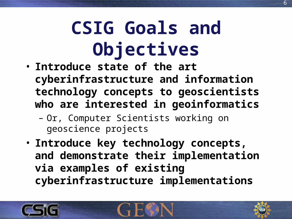
CSIG Goals and Objectives
• Introduce state of the art cyberinfrastructure and information technology concepts to geoscientists who are interested in geoinformatics– Or, Computer Scientists working on geoscience projects
• Introduce key technology concepts, and demonstrate their implementation via examples of existing cyberinfrastructure implementations
6

Content Goals
• From original proposal: “The Summer Institute will be organized around courses on topics that are most relevant to the current needs of geoscientists. These include courses in”: – Data management– Web Services– Grid technology– Geographic Information Systems– Parallel processing– Scientific Workflows
7

Institute Statistics
• ~230 alumni• 3-7 non-US attendees each year (Mexico, Japan, Korea, Ireland, Turkey, New Zealand,…)
8

Instructors: Non-SDSC (23)
9
San Diego• Bock, Yehuda, SIO (1)• Graham, John, SDSU (1)• Kilb, Debi, SIO (2)• Kuester, Falko, UCSD (1)• Walter, Fabian, SIO (1)
Non-San Diego• Ahern, Tim, IRIS (1)• Allison, Lee, AZGS (1)• Arrowsmith, Ramon, ASU (3)• Clark, Ryan, AZGS (1) • Davis, Lynne, DLESE (1)• Erickson, Susan, UNAVCO, (1)
• Fox, Peter, NCAR (2)
• Gates, Ann, UTEP (2)
• Keller, Randy, UTEP/UOK (3)
• Kirk, Karin, Carleton U. (1)
• Maechling, Phil, SCEC (2)
• Meertens, Chuck, UNAVCO, (2)
• Middleton, Don, NCAR (1)
• Miller, Chris, Purdue, (1)
• Rees, Allister, U. Arizona (1)
• Richards, Steve, AZGS (1)
• Sinha, Krishna, VaTech (2)
• Weir, Stuart, UNAVCO (2)

Instructors: SDSC (22)• Altintas, Ilkay (5)• Baru, Chaitan (5)• Bhatia, Karan (3)• Condit, Christopher (1)• Crosby, Christopher (3)• Ding, Longjiang (1)• Jaeger, Efrat (2)• Kaiser, Tim (1)• Krishnan, Sriram (4)• Lin, Kai (6)• Ludaescher, Bertram (2)
• Memon, Ashraf (4)• Memon, Ghulam (2)• Minor, David (1)• Moreland, John (3)• Nadeau, David (3)• Nandigam, Viswanath (2)• Seber, Dogan (3)• Valentine, David (1)• Wahadj, Reza (1)• Whitenack, Tom (1)• Zaslavsky, Ilya (4)
10
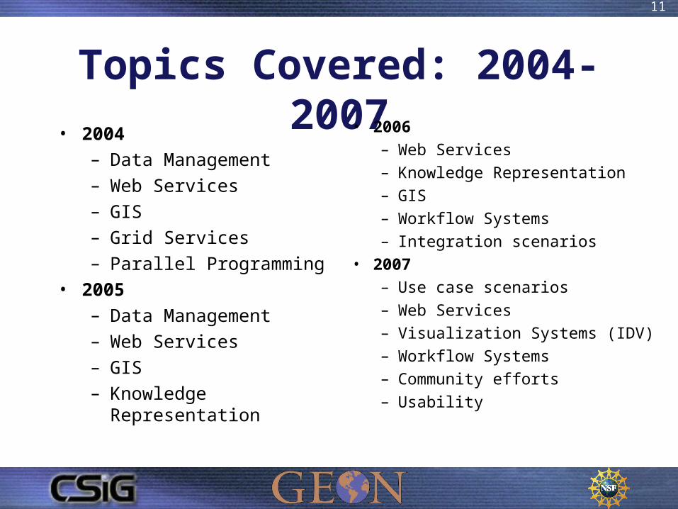
Topics Covered: 2004-2007• 2004
– Data Management
– Web Services
– GIS
– Grid Services
– Parallel Programming
• 2005
– Data Management
– Web Services
– GIS
– Knowledge Representation
• 2006– Web Services– Knowledge Representation– GIS– Workflow Systems– Integration scenarios
• 2007– Use case scenarios– Web Services– Visualization Systems (IDV)– Workflow Systems– Community efforts– Usability
11

Topics Covered: 2008
• Use case scenarios
• Data integration /
X-Informatics
• Visualization: OpenEarth Framework (OEF) and GEON IDV
• Portals Web Services (at a high level)
• Available resources with examples, e.g. CUAHSI HIS, SCEC,
• GEON LiDAR processing, OpenTopography portal
• Data integration,
• Scientific workflows
12

Topics Covered: 2009• Split into concurrent “Build Track” and “Education
Track– Cover same/similar material from different perspective:
understanding the technology vs using in education
• Build Track– Web Services, GeoSciML, Portals, OpenTopography technology,
Visualization open source tools and OEF
– Overview of Cloud computing
• Education Track– Using EarthScope data in education; LiDAR for K-12 and
undergrad classes; Visualization tools for education
13

14
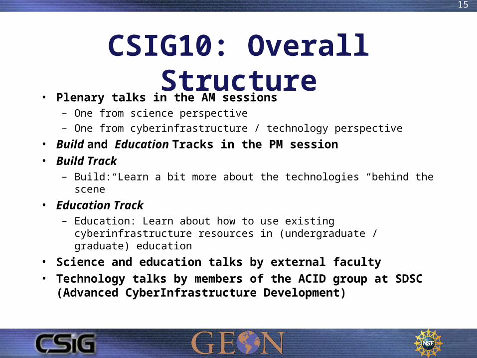
CSIG10: Overall Structure• Plenary talks in the AM sessions
– One from science perspective
– One from cyberinfrastructure / technology perspective
• Build and Education Tracks in the PM session
• Build Track– Build: Learn a bit more about the technologies “behind the scene”
• Education Track– Education: Learn about how to use existing cyberinfrastructure resources
in (undergraduate / graduate) education
• Science and education talks by external faculty
• Technology talks by members of the ACID group at SDSC (Advanced CyberInfrastructure Development)
15

CSIG10 Schedule• Monday
– Introduction to cyberinfrastructure and geoinformatics– Poster session and demos
• Tuesday - Thursday– Format
• AM: Plenary talks on science and related technologies
• PM: Build and Education Tracks
– Topics• Tue: EarthScope science and CI• Wed: Topography and remote sensing data• Thurs: Integrated Earth Models
• Friday– Summary, discussions, planning for collaborations, etc. – Machine room tour
16

Schedule17

CSIG Acknowledgements
• Dr. Margaret Leinen, ex-Assistant Director, NSF/GEO– Summer institute idea arose from a discussion with Dr.
Leinen in 2003 re. a training program in CI for geoscientists
• GEON– GEON started as an NSF ITR (IT Research) project focused
on “integration” of heterogeneous (geologic + geophysical), multidimensional earth science data
– GEON ITR was a collaboration among 12 PI institutions
18
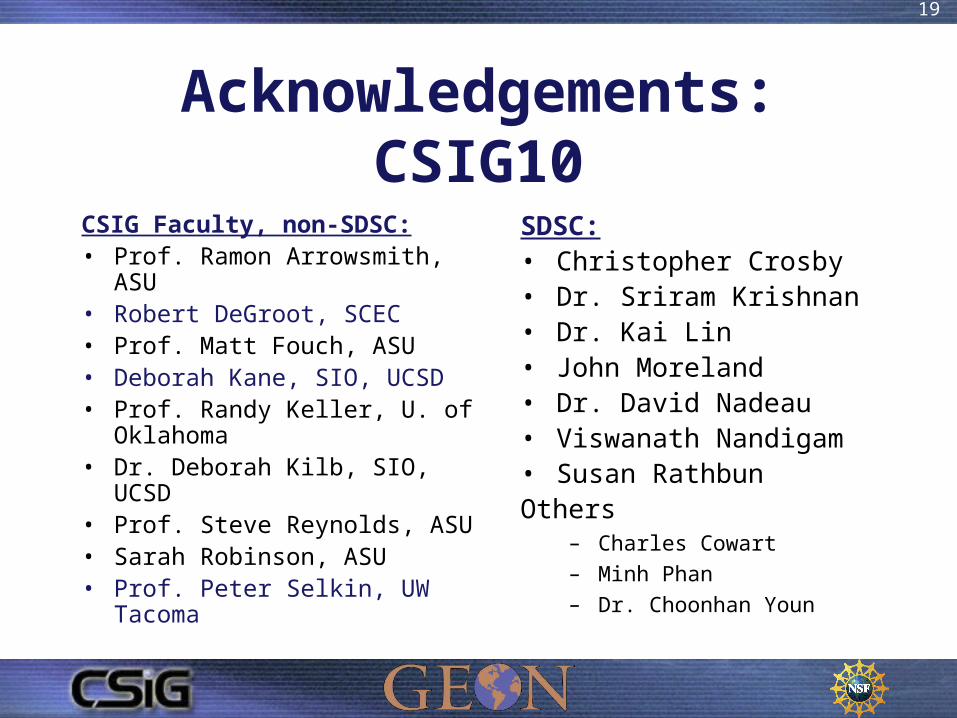
Acknowledgements: CSIG10
CSIG Faculty, non-SDSC:• Prof. Ramon Arrowsmith, ASU• Robert DeGroot, SCEC• Prof. Matt Fouch, ASU• Deborah Kane, SIO, UCSD• Prof. Randy Keller, U. of
Oklahoma• Dr. Deborah Kilb, SIO, UCSD• Prof. Steve Reynolds, ASU• Sarah Robinson, ASU• Prof. Peter Selkin, UW Tacoma
SDSC:• Christopher Crosby• Dr. Sriram Krishnan• Dr. Kai Lin• John Moreland• Dr. David Nadeau• Viswanath Nandigam• Susan RathbunOthers
– Charles Cowart
– Minh Phan
– Dr. Choonhan Youn
19
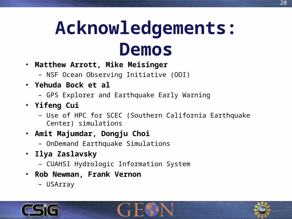
Acknowledgements: Demos• Matthew Arrott, Mike Meisinger
– NSF Ocean Observing Initiative (OOI)
• Yehuda Bock et al– GPS Explorer and Earthquake Early Warning
• Yifeng Cui– Use of HPC for SCEC (Southern California Earthquake Center) simulations
• Amit Majumdar, Dongju Choi– OnDemand Earthquake Simulations
• Ilya Zaslavsky– CUAHSI Hydrologic Information System
• Rob Newman, Frank Vernon– USArray
20

21
Acknowledgement to NSF• National Science Foundation
• CSIG has been funded each year as a supplement to GEON, since 2004
• GEON is currently funded by the NSF under grant #0722449
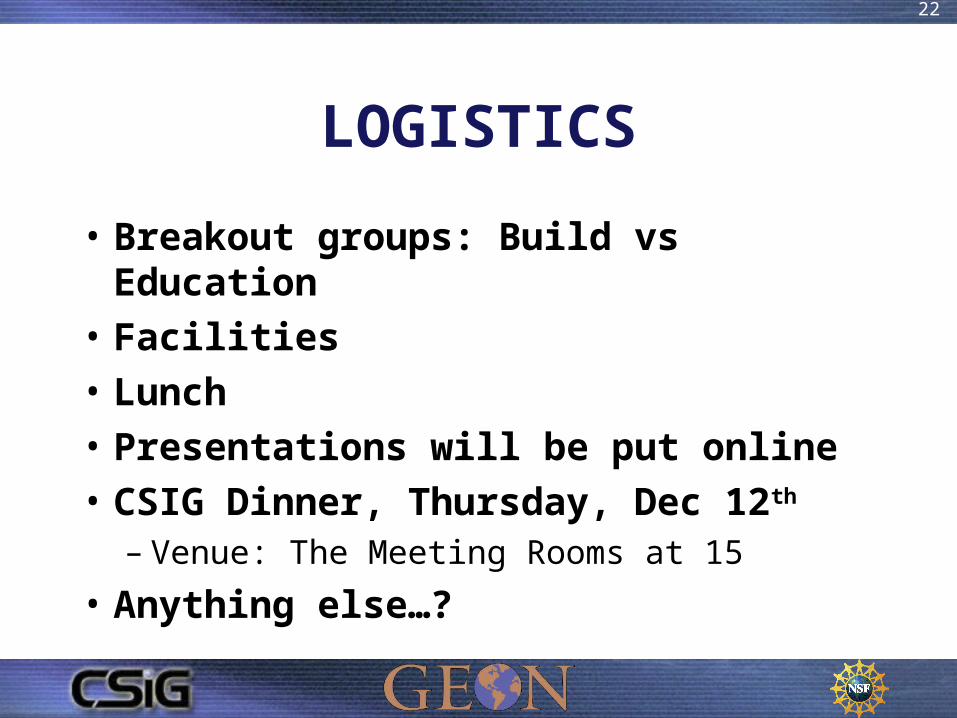
LOGISTICS
• Breakout groups: Build vs Education
• Facilities
• Lunch
• Presentations will be put online
• CSIG Dinner, Thursday, Dec 12th
– Venue: The Meeting Rooms at 15
• Anything else…?
22
23
Introductions

Attendees - 1
24
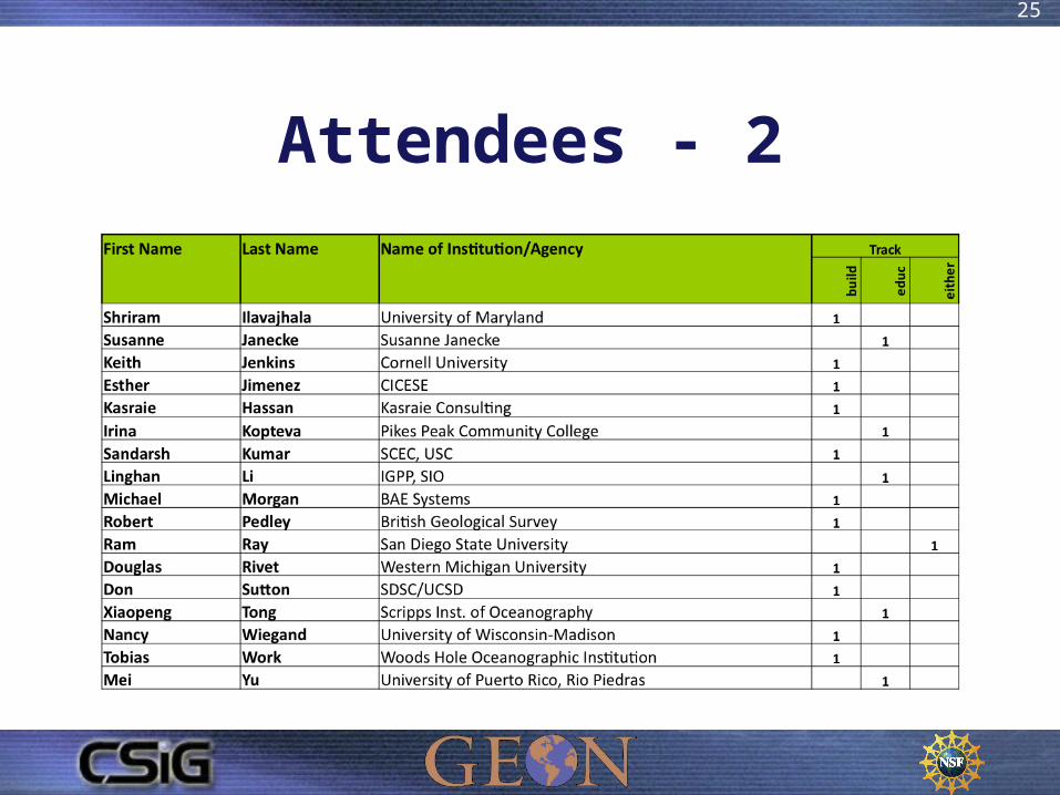
Attendees - 2
25


![CSIG protezione delle informazioni aziendali [I parte]](https://img.pdfslide.net/doc/110x75/559307cb1a28ab1e498b45db/csig-protezione-delle-informazioni-aziendali-i-parte.jpg)