Embed Size (px)
DESCRIPTION
manual
Citation preview

Connecticut’s Geospatial Newsletter
Fall Edition 2009
Volume 2, Issue 3
CONNECTICUT Geo-Focus
Newsletter Contacts Submit letters and articles to: [email protected] or
[email protected] These articles are published for the education and enjoyment of the GIS community, and may be edited to fit space available. The CT Geospatial Council does not endorse or recommend any software
programs.
Articles from the Geo Desk
Image Records MTG System….pg 1 J. Durling, DOT, Office of ROW GIS in the Siting Council…..…..pg 2 D. Phelps, Siting Council Exec. Director National Geography Bee…….....pg 3 B. DeGrazia, CT BEE Coordinator GeoDesk Maps & Trivia……....pg 4 Mapping Federal Lands…….....pg 5 W. Westphal USAF, Hollowman AFB CT Broadband Internet Service T. Kleykamp, OPM Native N.A. Languages………...pg 6 K. Schroeder, Unv. of California, Davis Municipal Update: Greenwich ..pg 7 G. Sullivan, GIS Greenwich Earthquakes in N. E. ……..…....pg 8 D. Smith, Weston Observatory, Boston College CT Generation Plants…..……...pg 9 M. Macionus, GIS CERC CT Thematic Map Contest…...pg 10 GIS Day Event Flyer T. Dymkowski, GIS Newington B. Stewart-Kelly, GIS State Military
From the GeoDESK
Upcoming Conferences NEARC 2009
Northeast ARC Users Group Oct 4-7
Radison Hotel, Nashua, NH http://www.northeastarc.org/
URISA's 47th Annual Conference
& Exposition September 29 - October 2, 2009
In 1999, the Department of Transportation (DOT), Office of Rights of Way, im-plemented an electronic document management system that provides access to ap-proximately two million digital documents and maps. The program is identified as the “Image Records Management System” or IRMS. In addition to document and map images, the program also provides access to the associated parcel data for all transportation con-struction projects. The Department of Transportation is currently upgrading the program. This upgrade will inte-grate the IRMS with Geographic Information System (GIS) technology. We will now be able to access the IRMS data and have the option of using the “view parcel” button to locate the prop-erty in its geospa-tially-correct environment. The GIS “map window” will allow the user to access Department of Environmental Protection and Department of Transportation data layers, including wetlands, hydrography, bridges, DOT facilities, commuter park-ing lots, and railroad data, as well as a number of Town Assessor maps. We will be using a map-based support system that interfaces with the critical information in the IRMS to create an integrated solution for greater productivity and increased analysis capabilities. The Office of Rights of Way personnel will gain a greater understanding of the impact of our road construction projects, resulting in a more efficient right of way acquisition or release process. The spirit of cooperation and teamwork demonstrated between the Depart-ment’s Office of Rights of Way, Surveys, Planning, Information Systems, and En-gineering, as well as a number of Connecticut municipalities that have contributed GIS data to our project, were key in achieving the technological advancements on this project. This cooperative effort illustrates what can be accomplished when everyone works together toward a common goal.
Image Records Management System By John O. Durling, D.O.T. Office of Rights Of Way
Connecticut’s Geospatial Newsletter
Fall Edition 2009
Volume 2, Issue 3
CONNECTICUT Geo-Focus
From the GeoDESK
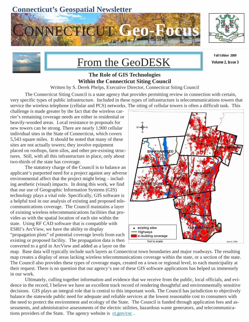
The Connecticut Siting Council is a state agency that provides permitting review in connection with certain, very specific types of public infrastructure. Included in these types of infrastructure is telecommunications towers that service the wireless telephone (cellular and PCS) networks. The siting of cellular towers is often a difficult task. This challenge is made greater by the fact that the wireless car-rier’s remaining coverage needs are either in residential or heavily-wooded areas. Local resistance to proposals for new towers can be strong. There are nearly 1,900 cellular individual sites in the State of Connecticut, which covers 5,543 square miles. It should be noted that many of these sites are not actually towers; they involve equipment placed on rooftops, farm silos, and other pre-existing struc-tures. Still, with all this infrastructure in place, only about two-thirds of the state has coverage. The statutory charge of the Council is to balance an applicant’s purported need for a project against any adverse environmental affect that the project might bring – includ-ing aesthetic (visual) impacts. In doing this work, we find that our use of Geographic Information Systems (GIS) technology plays a vital role. Specifically, GIS software is a helpful tool in our analysis of existing and proposed tele-communications coverage. The Council maintains a layer of existing wireless telecommunications facilities that pro-vides us with the spatial location of each site within the state. Using RF CAD software that is compatible with ESRI’s ArcView, we have the ability to display “propagation plots” of potential coverage levels from each existing or proposed facility. The propagation data is then converted to a grid in ArcView and added as a layer on the map. Base data will typically include such layers as Connecticut town boundaries and major roadways. The resulting map creates a display of areas lacking wireless telecommunications coverage within the state, or a section of the state. The Council also provides these types of coverage maps, created on a town or regional level, to each municipality at their request. There is no question that our agency’s use of these GIS software applications has helped us immensely in our work. Ultimately, culling together information and evidence that we receive from the public, local officials, and evi-dence in the record, I believe we have an excellent track record of rendering thoughtful and environmentally sensitive decisions. GIS plays an integral role that is central to this important work. The Council has jurisdiction to objectively balance the statewide public need for adequate and reliable services at the lowest reasonable cost to consumers with the need to protect the environment and ecology of the State. The Council is funded through application fees and as-sessments, and administrative assessments of the electric utilities, hazardous waste generators, and telecommunica-tions providers of the State. The agency website is ct.gov/csc .
The Role of GIS Technologies Within the Connecticut Siting Council
Written by S. Derek Phelps, Executive Director, Connecticut Siting Council
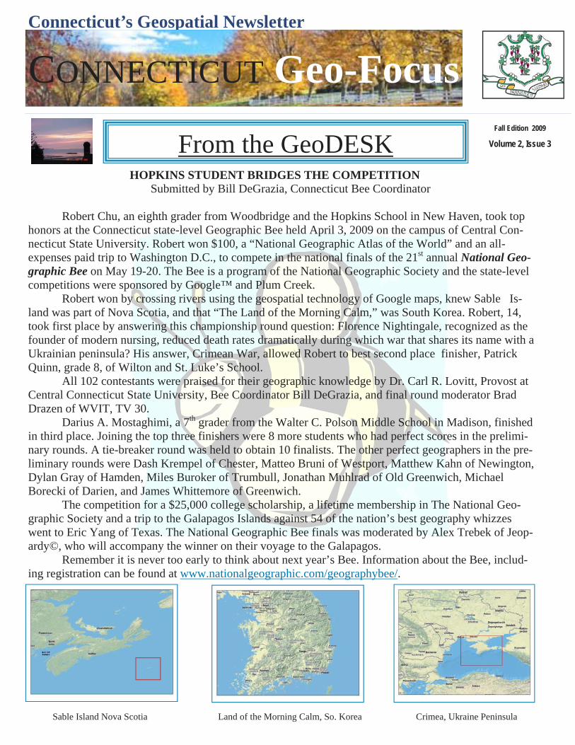
HOPKINS STUDENT BRIDGES THE COMPETITION Submitted by Bill DeGrazia, Connecticut Bee Coordinator Robert Chu, an eighth grader from Woodbridge and the Hopkins School in New Haven, took top honors at the Connecticut state-level Geographic Bee held April 3, 2009 on the campus of Central Con-necticut State University. Robert won $100, a “National Geographic Atlas of the World” and an all-expenses paid trip to Washington D.C., to compete in the national finals of the 21st annual National Geo-graphic Bee on May 19-20. The Bee is a program of the National Geographic Society and the state-level competitions were sponsored by Google™ and Plum Creek. Robert won by crossing rivers using the geospatial technology of Google maps, knew Sable Is-land was part of Nova Scotia, and that “The Land of the Morning Calm,” was South Korea. Robert, 14, took first place by answering this championship round question: Florence Nightingale, recognized as the founder of modern nursing, reduced death rates dramatically during which war that shares its name with a Ukrainian peninsula? His answer, Crimean War, allowed Robert to best second place finisher, Patrick Quinn, grade 8, of Wilton and St. Luke’s School. All 102 contestants were praised for their geographic knowledge by Dr. Carl R. Lovitt, Provost at Central Connecticut State University, Bee Coordinator Bill DeGrazia, and final round moderator Brad Drazen of WVIT, TV 30. Darius A. Mostaghimi, a 7th grader from the Walter C. Polson Middle School in Madison, finished in third place. Joining the top three finishers were 8 more students who had perfect scores in the prelimi-nary rounds. A tie-breaker round was held to obtain 10 finalists. The other perfect geographers in the pre-liminary rounds were Dash Krempel of Chester, Matteo Bruni of Westport, Matthew Kahn of Newington, Dylan Gray of Hamden, Miles Buroker of Trumbull, Jonathan Muhlrad of Old Greenwich, Michael Borecki of Darien, and James Whittemore of Greenwich. The competition for a $25,000 college scholarship, a lifetime membership in The National Geo-graphic Society and a trip to the Galapagos Islands against 54 of the nation’s best geography whizzes went to Eric Yang of Texas. The National Geographic Bee finals was moderated by Alex Trebek of Jeop-ardy©, who will accompany the winner on their voyage to the Galapagos. Remember it is never too early to think about next year’s Bee. Information about the Bee, includ-ing registration can be found at www.nationalgeographic.com/geographybee/.
Connecticut’s Geospatial Newsletter
Fall Edition 2009
Volume 2, Issue 3
CONNECTICUT Geo-Focus
From the GeoDESK
Sable Island Nova Scotia Land of the Morning Calm, So. Korea Crimea, Ukraine Peninsula
Connecticut’s Geospatial Newsletter
Fall Edition 2009
Volume 2, Issue 3
CONNECTICUT Geo-Focus
“As a young man, my fondest dream was to
become a geographer. However,
while working in the customs office
I thought deeply about the matter and concluded
it was too difficult a subject.
With some reluctance I then turned to
physics as a substitute.”
Albert Einstein (1879-1955)
GeoDESK Maps & Trivia
Geography Quotes
Sign Up for the UCONN ListServ so you can automatically receive the CT Geospatial Newsletter. The “Connecticut Geo-Focus”, the CT Geospatial Council, Education & Outreach Quarterly Newsletter.
Go to the UCONN website and sign on to the http://listserv.uconn.edu/ctgis-l.html
United States National Geodetic Survey (NGS) GPS Orbit Information The United States National Geodetic Survey (NGS) of the National Oceanic and Atmos-pheric Administration manages the National and Cooperative CORS (Continuously Oper-ating Reference Station) Network. This net-work currently contains more than 1,400 GPS data-collection sites in the United States and its territories, with a few in for-eign countries. NGS provides free access to GPS data from these sites via the internet. CORS data serves to monitor crustal motion, the distribution of moisture in the atmos-phere, and the distribution of free electrons in the ionosphere. NGS also provides the On-line Positioning User Service (OPUS). This web based utility enables users to sub-mit static GPS data for automatic processing with relevant CORS data. For information: Contact NGS at http://www.ngs.noaa.gov.
So, What Exactly Is Broadband ? Broadband or high-speed Internet access allows users to access the Internet and Internet-related services at significantly higher speeds than those available through “dial-up” Internet access services. Broadband speeds vary signifi-cantly depending on the particular type and level of service ordered and may range from as low as 200 kilobits per second (kbps), or 200,000 bits per sec-ond, to six megabits per second (Mbps), or 6,000,000 bits per second. Broad-band services for residential consumers typically provide faster downstream speeds (from the Internet to your computer) than upstream speeds (from your computer to the Internet). By FCC.
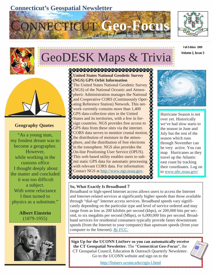
Hurricane Season is not over yet. Historically we‘ve had slow starts to the season in June and July but the rest of the season which runs through November can be very active. You can map Hurricanes as they travel up the Atlantic east coast by tracking their coordinates. Log on to www.nhc.noaa.gov/
Connecticut’s Geospatial Newsletter
Fall Edition 2009
Volume 2, Issue 3
CONNECTICUT Geo-Focus
From the GeoDESK For History Teachers: Map Resource with Indian and Federal Lands By Wesley Westphal, USAF Holloman Air Force Base The Federal Government owns nearly 650 million acres of land - almost 30 percent of the land area of the United States. Federally-owned and managed public lands include National Parks, National Forests, and National Wildlife Refuges. These are lands that are held for all Americans. The Federal agencies responsible for managing America's natural resources must meet both the public desire to protect them and the public expectation of economic growth based on them. Within the Federal Government, a number of agencies contribute to the management of natural resources associated with public lands. All of these Federal agencies are partners in the production of the nationalatlas.gov. In the United States there are only two kinds of reserved lands that are well-known: military and Indian. An Indian Reservation is land reserved for a tribe when it relinquished its other land areas to the United States through treaties. There are approximately 275 Indian land areas in the United States administered as Indian Reservations (reservations, pueblos, rancherias, communities, etc.). The largest is the Navajo Reservation of some 16 million acres of land in Arizona, New Mexico, and Utah. On each Reservation, the local governing authority is the tribal government. Military reservations are managed by the Department of Defense. These maps were designed for use on the World Wide Web or for generating high quality color prints. In addition, there is a map showing Federal Lands and Indian Reservations for the entire United States. Go To: http://www.nationalatlas.gov/printable/fedlands.html#list
Wednesday, November 18th is a day to save on your calendar for Connecticut's 3rd Annual GIS Day Event
Sponsored by the CT Geospatial Council and the Education & Outreach Working Group www.ct.gov/gis
The event will be held at the Legislative Office Building at Capitol Avenue in Hartford. Parking has been re-served in the LOB garage for the event. There is a full line up of presentations this year followed by the CT Geospatial Councils Meeting where the public is invited.
Broadband Internet Service: Stay Tuned By Tyler Kleykamp, OPM The State of Connecticut submitted an application to the National Telecommunications and Information Admini-stration to develop a statewide map that reflects the availability of broadband internet service. The application was submitted under the State Broadband Data and Development act that was recently funded through the American Recovery and Reinvestment Act. The State’s application seeks to develop a highly accurate map that allows for the identification of the number of broadband service providers as well as the characteristics of their service, at the address level. The State intends to make this map publicly available via the internet using a web-based GIS appli-cation. This is a competitive program and awards will be made in early October.
Connecticut’s Geospatial Newsletter
Fall Edition 2009
Volume 2, Issue 3
CONNECTICUT Geo-Focus
From the GeoDESK Map of Native North American Languages at European Contact
By Kari Schroeder, University of California, Davis. August 2009 As a molecular anthropologist, I make inferences about human population prehistory that are based on genetic variation. My work focuses on the population prehistory of Native Americans. While I was a graduate student in the Molecular Anthropology Lab of Dr. David Glenn Smith at the University of California, Davis, I analyzed ge-netic data from 15 Native North American populations. One of the questions Dr. Smith and I considered is whether the biological relatedness of two Native North American populations can be predicted by the geographic distance between the same two populations. However, such a pattern would be the result of long-term processes, and historical records show that many Native American groups fled or were forcibly moved from the areas they
inhabited at European contact. All three of Greenberg’s lan-guage families (Eskimo-Aleut, Na-Dene and Amerind are represented in the study. Hence, calculating geographic distances between the locations where biological samples were collected from modern individuals would introduce error. A more appropri-ate measure would be based on the estimated spatial distri-butions of Native North American populations at European contact. Our approach began with a published paper map of the estimated distributions of Native North American lan-guages at contact, compiled by Ives Goddard, which accom-panies Volume 17: Languages (1996) of the Handbook of North American Indians (Smithsonian Institution, Washing-ton D.C.). The map was scanned on a drum scanner, and a digital version of the map was georeferenced in ArcMap 9.2. Polygons were then drawn on the georeferenced map, around the language areas of the populations sampled in the study, and the centroids of each language area was calcu-lated. Distances between each pair of centroids were com-puted using the great circle distance. Based on the assump-tion that the majority of population movement has not oc-
curred over large bodies of water, waypoints were incorporated into the distances between centroids. Bearing in mind the caveat that ethno linguistic groups do not always represent biological populations, by incorporating GIS into our analysis we were able to arrive at rough estimates of the distances between biological populations at the time of European contact. This, in turn, increased the accuracy of our estimate of the relationship between biologi-cal relatedness and geographic distance among Native North American populations.
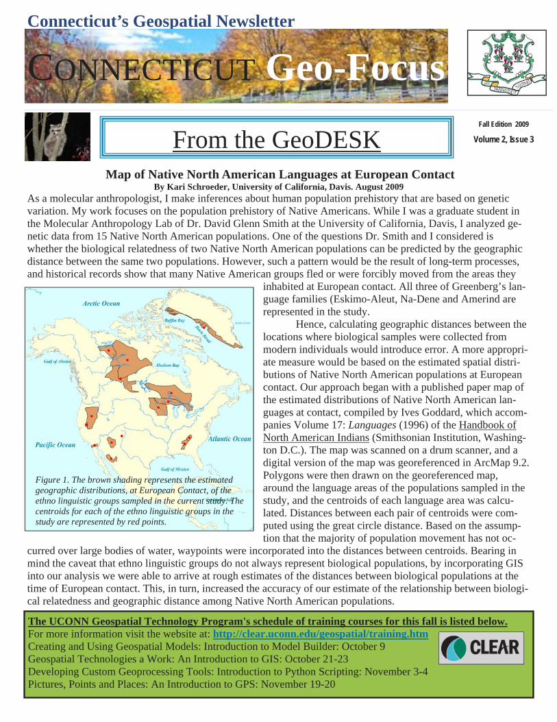
Figure 1. The brown shading represents the estimated geographic distributions, at European Contact, of the ethno linguistic groups sampled in the current study. The centroids for each of the ethno linguistic groups in the study are represented by red points.
The UCONN Geospatial Technology Program's schedule of training courses for this fall is listed below. For more information visit the website at: http://clear.uconn.edu/geospatial/training.htm Creating and Using Geospatial Models: Introduction to Model Builder: October 9 Geospatial Technologies a Work: An Introduction to GIS: October 21-23 Developing Custom Geoprocessing Tools: Introduction to Python Scripting: November 3-4 Pictures, Points and Places: An Introduction to GPS: November 19-20

Connecticut’s Geospatial Newsletter
Fall Edition 2009
Volume 2, Issue 3
CONNECTICUT Geo-Focus
From the GeoDESK
The Connecticut Department of Environmental Protection is pleased to announce that new imagery is available to the public at no cost. This imagery includes the 1990 Orthophotos, 2004 Orthophotos, 2006 NAIP Orthophotos, 2008 NAIP Orthophotos, 2004 Coastal Orthophotos, 2004 Coastal Infrared Orthophotos, and 2005 Coastal Infrared Orthophotos. These datasets are available as statewide mosaics in ArcGIS 9.3 file geodatabase raster dataset format. To obtain these datasets, you need to submit an external storage device to the DEP, upon which the requested information will be copied. Once copied, you must pick up your storage device. DEP will not ship the device back to you unless postage is pre-paid. Total file size for all of the imagery is 200 GB. For more information, visit Connecticut Imagery Available from DEP at http://www.ct.gov/dep/cwp/view.asp?
Municipal Update Town of Greenwich Greg Sullivan, GIS Greenwich The Town of Greenwich, CT has completed it's 2008 digital orthophoto base map update. This is the second up-date of the Town's GIS base map, originally created in 1997. For this update, the Town acquired color infrared (CIR) photography, in addition to the red-green-blue (RGB) spectrum color photography. The CIR imagery is be-ing used to update and enhance the Town's vegetative cover layer. In addition to color photography, the base map update included updated 2-foot contours, building footprints, edge-of-pavement, hydrography, and surface utilities (hydrants, manholes, poles, trees). It's available to all Town Hall users via Intranet, and we're working on a self-contained kiosk for remote sites, at which point the foundation will be set for Internet availability.
Connecticut’s Geospatial Newsletter
Fall Edition 2009
Volume 2, Issue 3
CONNECTICUT Geo-Focus
From the GeoDESK Earthquake Monitoring in New England
By Dina Smith, Weston Observatory of Boston College “There aren’t earthquakes in New England” is a statement frequently heard when the subject of New Eng-land earthquakes comes up. The reality is quite the contrary; there is an extensive history of earthquakes, big and small, in the six New England states and surrounding area. References to earthquakes are found in the oral history of Native Americans, in the written history of European settlers to New England and in more modern newspaper
archives. Large, destructive earthquakes have occurred in New England; a 6.1 magnitude earthquake occurred off the coast of Cape Ann, MA in No-vember 1755, a magnitude 5.6 earthquake struck the Newburyport, MA area in October of 1727 and more recently a pair of 5.5 earthquakes caused damage in the Ossipee region of NH in December, 1940. Today, the Weston Observatory of Boston College, Mass. http://www.bc.edu/westonobservatory operates a network of 14 seismo-graphs throughout New England to record ground motion, including earth-quakes. These seismographs, which consist of a seismometer, a data digi-tizer, and a GPS unit, send continuous streams of data to Weston Observa-tory computers which archive and analyze the data. When an earthquake occurs in one of the six New England states, seismologists at the Observatory collect and analyze the waveform data and determine the time, location
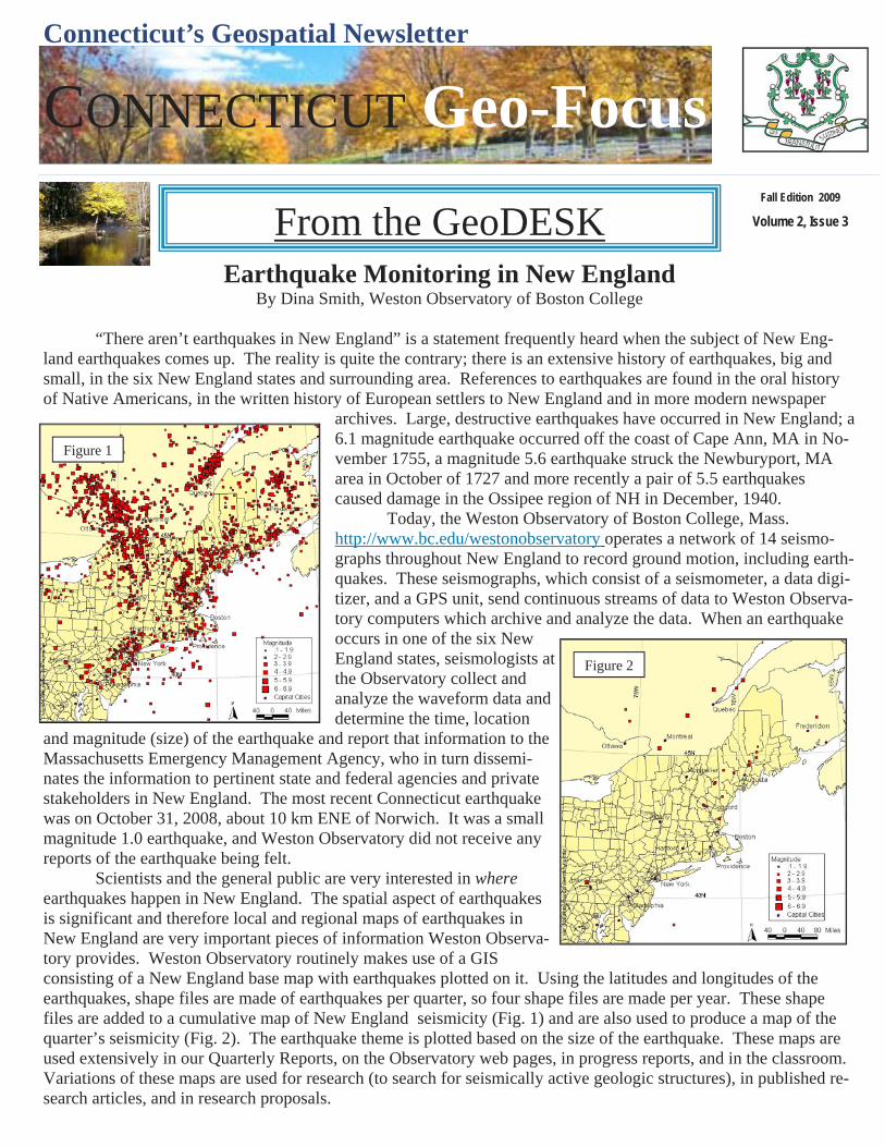
and magnitude (size) of the earthquake and report that information to the Massachusetts Emergency Management Agency, who in turn dissemi-nates the information to pertinent state and federal agencies and private stakeholders in New England. The most recent Connecticut earthquake was on October 31, 2008, about 10 km ENE of Norwich. It was a small magnitude 1.0 earthquake, and Weston Observatory did not receive any reports of the earthquake being felt. Scientists and the general public are very interested in where earthquakes happen in New England. The spatial aspect of earthquakes is significant and therefore local and regional maps of earthquakes in New England are very important pieces of information Weston Observa-tory provides. Weston Observatory routinely makes use of a GIS consisting of a New England base map with earthquakes plotted on it. Using the latitudes and longitudes of the earthquakes, shape files are made of earthquakes per quarter, so four shape files are made per year. These shape files are added to a cumulative map of New England seismicity (Fig. 1) and are also used to produce a map of the quarter’s seismicity (Fig. 2). The earthquake theme is plotted based on the size of the earthquake. These maps are used extensively in our Quarterly Reports, on the Observatory web pages, in progress reports, and in the classroom. Variations of these maps are used for research (to search for seismically active geologic structures), in published re-search articles, and in research proposals.
Figure 1
Figure 2
Connecticut’s Geospatial Newsletter
Fall Edition 2009
Volume 2, Issue 3
CONNECTICUT Geo-Focus
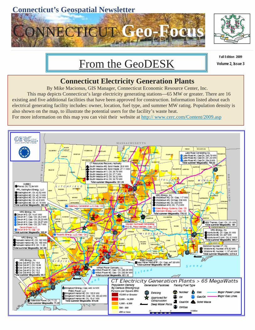
From the GeoDESK Connecticut Electricity Generation Plants
By Mike Macionus, GIS Manager, Connecticut Economic Resource Center, Inc. This map depicts Connecticut’s large electricity generating stations—65 MW or greater. There are 16 existing and five additional facilities that have been approved for construction. Information listed about each electrical generating facility includes: owner, location, fuel type, and summer MW rating. Population density is also shown on the map, to illustrate the potential users for the facility’s waste heat. For more information on this map you can visit their website at http:// www.cerc.com/Content/2009.asp
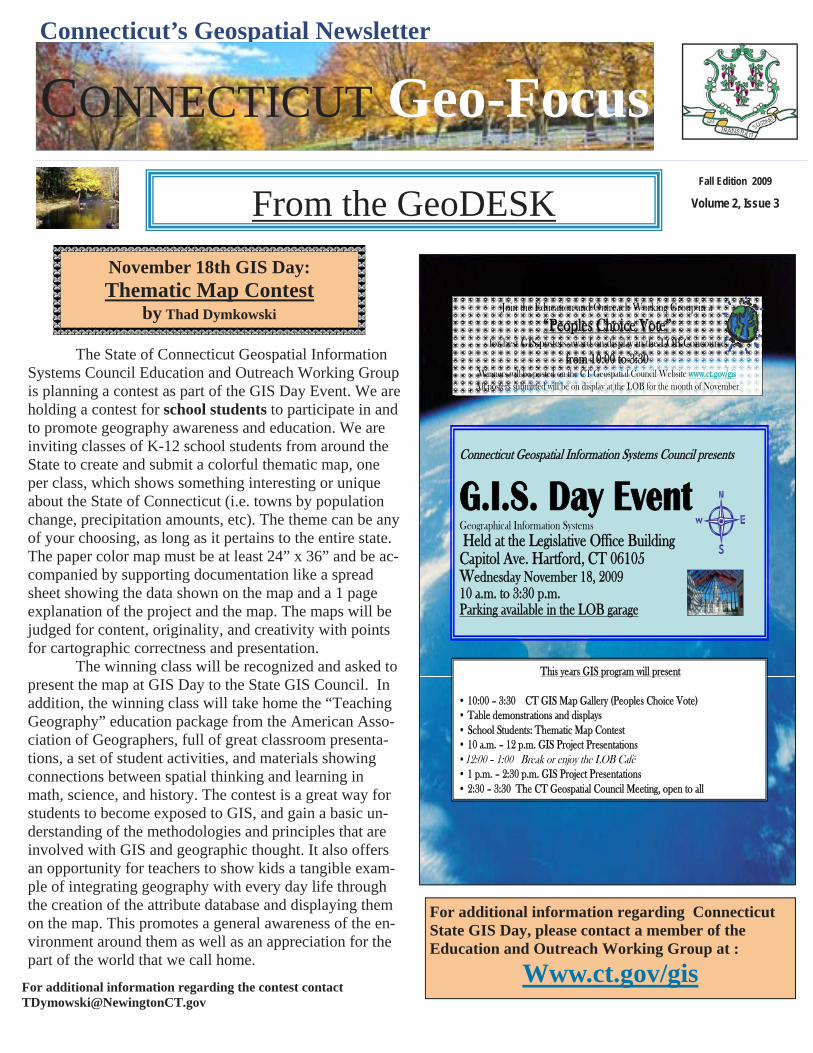
Connecticut Geospatial Information Systems Council presents
G.I.S. Day EventGeographical Information SystemsHeld at the Legislative Office Building
Capitol Ave. Hartford, CT 06105Wednesday November 18, 200910 a.m. to 3:30 p.m.Parking available in the LOB garage
This years GIS program will present
• 10:00 – 3:30 CT GIS Map Gallery (Peoples Choice Vote)• Table demonstrations and displays• School Students: Thematic Map Contest• 10 a.m. – 12 p.m. GIS Project Presentations •12:00 – 1:00 Break or enjoy the LOB Café• 1 p.m. – 2:30 p.m. GIS Project Presentations • 2:30 – 3:30 The CT Geospatial Council Meeting, open to all
Join the Education and Outreach Working Group in a
“Peoples Choice Vote”for best GIS posters award on display in the LOB Concourse
from 10:00 to 3:30Winners will be posted on the CT Geospatial Council Website www.ct.gov/gis
All posters submitted will be on display at the LOB for the month of November
Connecticut’s Geospatial Newsletter
Fall Edition 2009
Volume 2, Issue 3
CONNECTICUT Geo-Focus
From the GeoDESK
The State of Connecticut Geospatial Information Systems Council Education and Outreach Working Group is planning a contest as part of the GIS Day Event. We are holding a contest for school students to participate in and to promote geography awareness and education. We are inviting classes of K-12 school students from around the State to create and submit a colorful thematic map, one per class, which shows something interesting or unique about the State of Connecticut (i.e. towns by population change, precipitation amounts, etc). The theme can be any of your choosing, as long as it pertains to the entire state. The paper color map must be at least 24” x 36” and be ac-companied by supporting documentation like a spread sheet showing the data shown on the map and a 1 page explanation of the project and the map. The maps will be judged for content, originality, and creativity with points for cartographic correctness and presentation. The winning class will be recognized and asked to present the map at GIS Day to the State GIS Council. In addition, the winning class will take home the “Teaching Geography” education package from the American Asso-ciation of Geographers, full of great classroom presenta-tions, a set of student activities, and materials showing connections between spatial thinking and learning in math, science, and history. The contest is a great way for students to become exposed to GIS, and gain a basic un-derstanding of the methodologies and principles that are involved with GIS and geographic thought. It also offers an opportunity for teachers to show kids a tangible exam-ple of integrating geography with every day life through the creation of the attribute database and displaying them on the map. This promotes a general awareness of the en-vironment around them as well as an appreciation for the part of the world that we call home.
November 18th GIS Day: Thematic Map Contest
by Thad Dymkowski
For additional information regarding Connecticut State GIS Day, please contact a member of the Education and Outreach Working Group at :
Www.ct.gov/gis For additional information regarding the contest contact [email protected]