Embed Size (px)
Citation preview
City of London
Cultural Heritage Evaluation Report Wenige Expressway Bridge (4-BR-14) Highbury Avenue over the Thames River
Prepared by:
AECOM
410 – 250 York Street, Citi Plaza 519 673 0510 tel
London, ON, Canada N6A 6K2 519 673 5975 fax
www.aecom.com
January, 2018 Project Number: 60550772
City of London
Wenige Expressway Bridge (4-BR-14)
Cultural Heritage Evaluation Report
RPT-2018-01-16-Wenigeexpresswaybridgecher-60550772
Statement of Qualifications and Limitations
The attached Report (the “Report”) has been prepared by AECOM Canada Ltd. (“AECOM”) for the benefit of the Client (“Client”) in
accordance with the agreement between AECOM and Client, including the scope of work detailed therein (the “Agreement”).
The information, data, recommendations and conclusions contained in the Report (collectively, the “Information”):
is subject to the scope, schedule, and other constraints and limitations in the Agreement and the qualifications
contained in the Report (the “Limitations”);
represents AECOM’s professional judgement in light of the Limitations and industry standards for the preparation of
similar reports;
may be based on information provided to AECOM which has not been independently verified;
has not been updated since the date of issuance of the Report and its accuracy is limited to the time period and
circumstances in which it was collected, processed, made or issued;
must be read as a whole and sections thereof should not be read out of such context;
was prepared for the specific purposes described in the Report and the Agreement; and
in the case of subsurface, environmental or geotechnical conditions, may be based on limited testing and on the
assumption that such conditions are uniform and not variable either geographically or over time.
AECOM shall be entitled to rely upon the accuracy and completeness of information that was provided to it and has no
obligation to update such information. AECOM accepts no responsibility for any events or circumstances that may have
occurred since the date on which the Report was prepared and, in the case of subsurface, environmental or geotechnical
conditions, is not responsible for any variability in such conditions, geographically or over time.
AECOM agrees that the Report represents its professional judgement as described above and that the Information has been
prepared for the specific purpose and use described in the Report and the Agreement, but AECOM makes no other
representations, or any guarantees or warranties whatsoever, whether express or implied, with respect to the Report, the
Information or any part thereof.
Without in any way limiting the generality of the foregoing, any estimates or opinions regarding probable construction costs or
construction schedule provided by AECOM represent AECOM’s professional judgement in light of its experience and the
knowledge and information available to it at the time of preparation. Since AECOM has no control over market or economic
conditions, prices for construction labour, equipment or materials or bidding procedures, AECOM, its directors, officers and
employees are not able to, nor do they, make any representations, warranties or guarantees whatsoever, whether express or
implied, with respect to such estimates or opinions, or their variance from actual construction costs or schedules, and accept no
responsibility for any loss or damage arising therefrom or in any way related thereto. Persons relying on such estimates or
opinions do so at their own risk.
Except (1) as agreed to in writing by AECOM and Client; (2) as required by-law; or (3) to the extent used by governmental
reviewing agencies for the purpose of obtaining permits or approvals, the Report and the Information may be used and relied
upon only by Client.
AECOM accepts no responsibility, and denies any liability whatsoever, to parties other than Client who may obtain access to the
Report or the Information for any injury, loss or damage suffered by such parties arising from their use of, reliance upon, or
decisions or actions based on the Report or any of the Information (“improper use of the Report”), except to the extent those
parties have obtained the prior written consent of AECOM to use and rely upon the Report and the Information. Any injury, loss
or damages arising from improper use of the Report shall be borne by the party making such use.
This Statement of Qualifications and Limitations is attached to and forms part of the Report and any use of the Report is subject
to the terms hereof.
AECOM: 2015-04-13
© 2009-2015 AECOM Canada Ltd. All Rights Reserved.
City of London
Wenige Expressway Bridge (4-BR-14)
Cultural Heritage Evaluation Report
RPT-2018-01-16-Wenigeexpresswaybridgecher-60550772
Signatures
Report Prepared By:
Michael Greguol, MA
Cultural Heritage Specialist
Report Reviewed By:
Fern Mackenzie, MA, CAHP
Senior Architectural Historian
City of London
Wenige Expressway Bridge (4-BR-14)
Cultural Heritage Evaluation Report
RPT-2018-01-16-Wenigeexpresswaybridgecher-60550772
Distribution List
# Hard Copies PDF Required Association / Company Name
2 1 City of London
0 1 AECOM Canada Ltd.
Revision History
Revision # Date Revised By: Revision Description
0 November
21, 2017
Michael Greguol Draft Cultural Heritage Evaluation Report
1 January 16,
2018
Michael Greguol Cultural Heritage Evaluation Report
City of London
Wenige Expressway Bridge (4-BR-14)
Cultural Heritage Evaluation Report
RPT-2018-01-16-Wenigeexpresswaybridgecher-60550772
Executive Summary
AECOM Canada Ltd. (AECOM) was retained by the City of London to conduct a Cultural Heritage Evaluation
Report (CHER) as a part of a series of studies including a Preliminary Structural Design Report and Structural
Evaluation for the Wenige Expressway Bridge (Structure No. 4-BR-14) on Highbury Avenue over the South Branch
of the Thames River. At the time of the preparation, there is no specific proposed undertaking; however, the design
report being undertaken concurrently is anticipated to provide recommendations for rehabilitation activities for the
bridge.
This CHER was prepared according to the guidelines set out in the Ontario Ministry of Tourism, Culture, and
Sports’ Heritage Resources in the Land Use Planning Process document included as a part of the Ontario Heritage
Toolkit. For the purposes of this report, AECOM undertook the following tasks:
1) Preparation of a land use history of the Study Area based on a review of:
a) Primary and secondary resources;
b) Historic mapping.
2) A review of the City of London’s Inventory of Heritage Resources, as well as the Ontario Heritage Trust’s online
inventory of buildings, museums, and easement properties, the Canadian Register of Historic Places, and the
Directory of Federal Heritage Designations.
3) A site investigation, undertaken on August 29, 2017 to document the existing conditions of the bridge structure
and its associated landscape.
4) Evaluation of the bridge structure and its landscape using Ontario Regulation 9/06, Criteria for Determining
Cultural Heritage Value or Interest.
When evaluated according to the criteria outlined in Ontario Regulation 9/06, Criteria for Determining Cultural
Heritage Value or Interest, the bridge did not meet any of the criteria. As a result, the Wenige Expressway Bridge
does not contain cultural heritage value and thus a Statement of Cultural Heritage Value and a list of Heritage
Attributes were not developed. No further reporting related to cultural heritage is recommended for this structure.
City of London
Wenige Expressway Bridge (4-BR-14)
Cultural Heritage Evaluation Report
RPT-2018-01-16-Wenigeexpresswaybridgecher-60550772
Table of Contents
Page
1. Introduction ...................................................................................................................... 1
1.1 Study Purpose ................................................................................................................... 1
1.2 Study Method..................................................................................................................... 1
1.3 Metric Measurements ........................................................................................................ 1
2. Policy and Planning Framework ..................................................................................... 4
2.1 Environmental Assessment Act.......................................................................................... 4
2.2 Additional Guidelines ......................................................................................................... 4
2.3 City of London Official Plan ................................................................................................ 4
3. Historical Overview .......................................................................................................... 6
3.1 Natural Environment and Physical Setting ......................................................................... 6
3.2 Historic Context ................................................................................................................. 8
3.2.1 Local Historic Context ............................................................................................ 8
3.2.2 Highbury Avenue/Highway 126/Wenige Expressway ........................................... 10
3.2.3 Bridge Building Context ........................................................................................ 12
3.2.4 Wenige Expressway Bridge .................................................................................. 12
4. Site Description .............................................................................................................. 20
4.1 Context ............................................................................................................................ 20
4.2 Cultural Landscape .......................................................................................................... 20
4.3 Approaches ..................................................................................................................... 20
4.4 Abutments and Piers ........................................................................................................ 20
4.5 Girders/Deck/Railings ...................................................................................................... 21
5. Evaluation ....................................................................................................................... 31
5.1 Ontario Regulation 9/06 ................................................................................................... 31
5.2 Review of Heritage Registers and Additional Information ................................................. 32
6. Recommendations ......................................................................................................... 34
7. Bibliography ................................................................................................................... 35
List of Figures
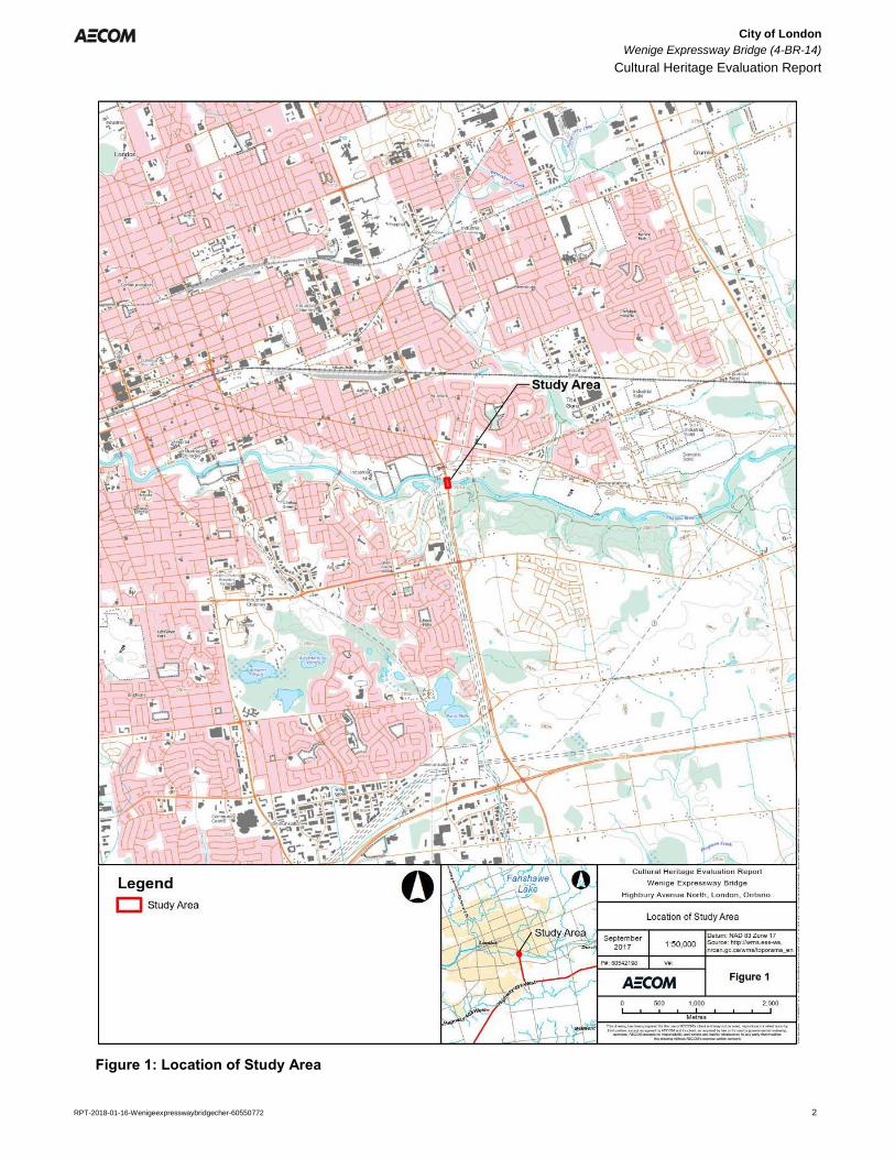
Figure 1: Location of Study Area .................................................................................................................................. 2
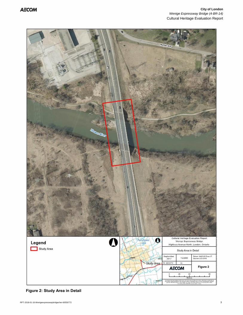
Figure 2: Study Area in Detail ....................................................................................................................................... 3
Figure 3: Study Area, 1878 (London Township) ......................................................................................................... 14
Figure 4: Study Area, 1878 (Westminster Township) ................................................................................................. 15
Figure 5: Study Area, 1913 ......................................................................................................................................... 16
City of London
Wenige Expressway Bridge (4-BR-14)
Cultural Heritage Evaluation Report
RPT-2018-01-16-Wenigeexpresswaybridgecher-60550772
Figure 6: Study Area, 1945 ......................................................................................................................................... 17
Figure 7: Study Area, 1955 ......................................................................................................................................... 18
List of Tables
Table 1: Ontario Regulation 9/06 Evaluation for the Wenige Expressway Bridge ..................................................... 31
Appendices
Appendix A. Department of Highways, Thames River Bridge, Highbury Ave. Extension, General Plan, 1960.
City of London
Wenige Expressway Bridge (4-BR-14)
Cultural Heritage Evaluation Report
RPT-2018-01-16-Wenigeexpresswaybridgecher-60550772 1
1. Introduction
1.1 Study Purpose
AECOM Canada Ltd. (AECOM) was retained by the City of London to conduct a Cultural Heritage Evaluation
Report (CHER) as a part of a series of studies including a Preliminary Structural Design Report and Structural
Evaluation for the Wenige Expressway Bridge (Structure No. 4-BR-14) on Highbury Avenue over the South Branch
of the Thames River (Figure 1 and Figure 2). At the time of the preparation, there is no specific proposed
undertaking; however, the design report being undertaken concurrently is anticipated to provide recommendations
for rehabilitation activities for the bridge.
1.2 Study Method
This CHER was prepared according to the guidelines set out in the Ontario Ministry of Tourism, Culture, and
Sports’ Heritage Resources in the Land Use Planning Process document included as a part of the Ontario Heritage
Toolkit. For the purposes of this report, AECOM undertook the following tasks:
1) Preparation of a land use history of the Study Area based on a review of:
a) Primary and secondary resources;
b) Historic mapping.
2) A review of the City of London’s Inventory of Heritage Resources, as well as the Ontario Heritage Trust’s online
inventory of buildings, museums, and easement properties, the Canadian Register of Historic Places, and the
Directory of Federal Heritage Designations.
3) A site investigation, undertaken on August 29, 2017 to document the existing conditions of the bridge structure
and its associated landscape.
4) Evaluation of the bridge structure and its landscape using Ontario Regulation 9/06, Criteria for Determining
Cultural Heritage Value or Interest.
1.3 Metric Measurements
Between 1971 and 1984 Canada adopted the metric system. All structural dimensions in this text are given in
Imperial units. In general, the use of Imperial rather than Metric is preferred for describing historic structures.
Engineered structures were often built to standard Imperial dimensions and distinctive patterns within such
structures can be obscured by converting the original Imperial to Metric units. Unless there are historical issues (i.e.
contract specifications), distances and other common measurements are given in Metric units.
City of London
Wenige Expressway Bridge (4-BR-14)
Cultural Heritage Evaluation Report
RPT-2018-01-16-Wenigeexpresswaybridgecher-60550772 2
Figure 1: Location of Study Area
City of London
Wenige Expressway Bridge (4-BR-14)
Cultural Heritage Evaluation Report
RPT-2018-01-16-Wenigeexpresswaybridgecher-60550772 3
Figure 2: Study Area in Detail
City of London
Wenige Expressway Bridge (4-BR-14)
Cultural Heritage Evaluation Report
RPT-2018-01-16-Wenigeexpresswaybridgecher-60550772 4
2. Policy and Planning Framework
2.1 Environmental Assessment Act
This report has been produced to satisfy cultural heritage reporting requirements typically undertaken as part of the
Ontario Environmental Assessment (EA) process. Pursuant to the Environmental Assessment Act (R.S.O. 1990,
Chapter E.18), applicable infrastructure improvements and development projects are subject to appropriate studies
to evaluate and assess the potential related impacts of a project on the social, economic, or cultural environment,
i.e. the cultural heritage of an area. Infrastructure improvement projects have the potential to impact cultural
heritage resources in various ways including, but no limited to:
Loss or displacement of resources through removal or demolition;
Disruption of resources by introducing physical, visual, audible, or atmospheric elements that are not in
keeping with the resources and their contextual surroundings.
It is understood that at this stage, an Environmental Assessment for the bridge project has not been initiated;
however, this report utilizes the methods and practice typically undertaken for cultural heritage reporting as required
by the EA process.
2.2 Additional Guidelines
The methods of analysis used in the cultural heritage resource assessment process addresses cultural heritage resources under various pieces of legislation and their supporting documentation:
Environmental Assessment Act (R.S.O. 1990, Chapter E.18)
o Guidelines for Preparing the Cultural Heritage Resource Component of Environmental
Assessments (MCC-MOE 1992)
o Guidelines on the Man-Made Heritage Component of Environmental Assessments (MCR-MOE
1981)
Planning Act (R.S.O. 1990, Chapter P.13)
o Heritage Resources in the Land Use Planning Process, 2005 Provincial Policy Statement
Ontario Heritage Act (R.S.O. 1990,Chapter O.18) and Ministry of Tourism, Culture, and Sport
o Ontario Heritage Toolkit (MCL 2006)
2.3 City of London Official Plan
The City of London Official Plan (OP) outlines a policy context for land use planning, amongst other items, within
the City of London. Chapter 13 of the OP identifies planning policies, goals, and objectives associated with the
identification, evaluation, and management of cultural heritage resources (built heritage, cultural heritage
landscapes, and archaeological resources) within the City. Specifically, the objectives of the OP as they relate to
heritage conservation include:
Protect in accordance with Provincial policy those heritage resources which contribute to the identity and
character of the City;
City of London
Wenige Expressway Bridge (4-BR-14)
Cultural Heritage Evaluation Report
RPT-2018-01-16-Wenigeexpresswaybridgecher-60550772 5
Encourage the protection, enhancement, restoration, maintenance, and utilization of buildings, structures,
areas, or sites within London which are considered to be of cultural heritage value or interest to the
community;
Encourage new development, redevelopment, and public works to be sensitive to, and in harmony with, the
City's heritage resources; and
Increase public awareness and appreciation of the City's heritage resources, and encourage participation
by the public, corporations, and other levels of government in the protection, restoration, and utilization of
these resources.
In addition, the City maintains a descriptive inventory of properties of cultural heritage value or interest. The City of
London’s Inventory of Heritage Resources (2006) includes information related to the listing of properties in London.
The inventory includes a priority level system for identifying properties of greater priority and/or significance for
heritage recognition. In addition, properties designated under the Ontario Heritage Act are maintained in the City’s
inventory. The inventory is a living document subject to changes and approvals by City Council, advised by the
London Advisory Committee on Heritage.
Lastly, the City of London’s Strategic Plan set out a broad direction for the future of London. It identifies London
City Council’s vision, mission, values, strategic areas for focus and the specific strategies that define how Council
and Administration will respond to the needs and aspirations of Londoners. As such, as part of the City’s initiative
for “Building a Sustainable City,” the Strategic Plan identifies the management of upgrading of transportation
infrastructure such as heritage bridges, and more specifically, the Heritage Bridge Preservation Strategy as a part
of its focus on robust infrastructure.
City of London
Wenige Expressway Bridge (4-BR-14)
Cultural Heritage Evaluation Report
RPT-2018-01-16-Wenigeexpresswaybridgecher-60550772 6
3. Historical Overview
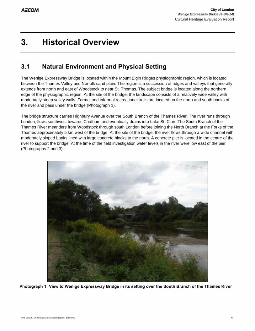
3.1 Natural Environment and Physical Setting
The Wenige Expressway Bridge is located within the Mount Elgin Ridges physiographic region, which is located
between the Thames Valley and Norfolk sand plain. The region is a succession of ridges and valleys that generally
extends from north and east of Woodstock to near St. Thomas. The subject bridge is located along the northern
edge of the physiographic region. At the site of the bridge, the landscape consists of a relatively wide valley with
moderately steep valley walls. Formal and informal recreational trails are located on the north and south banks of
the river and pass under the bridge (Photograph 1).
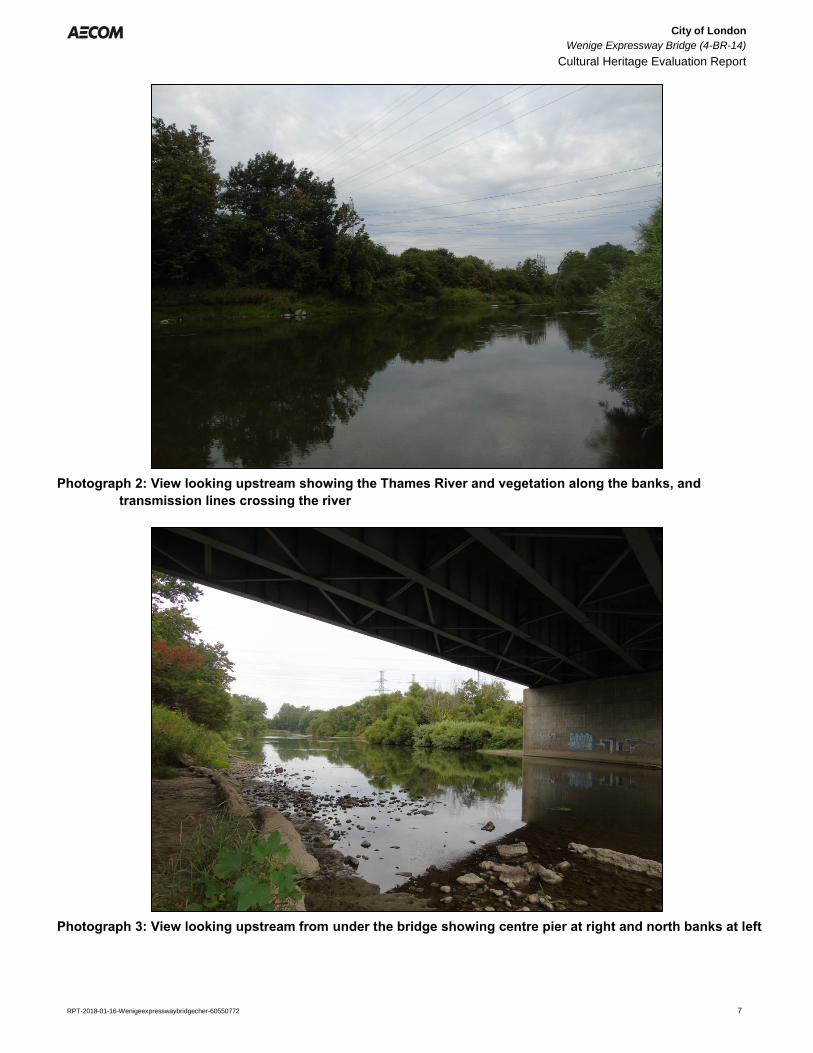
The bridge structure carries Highbury Avenue over the South Branch of the Thames River. The river runs through
London, flows southwest towards Chatham and eventually drains into Lake St. Clair. The South Branch of the
Thames River meanders from Woodstock through south London before joining the North Branch at the Forks of the
Thames approximately 5 km west of the bridge. At the site of the bridge, the river flows through a wide channel with
moderately sloped banks lined with large concrete blocks to the north. A concrete pier is located in the centre of the
river to support the bridge. At the time of the field investigation water levels in the river were low east of the pier
(Photographs 2 and 3).
Photograph 1: View to Wenige Expressway Bridge in its setting over the South Branch of the Thames River
City of London
Wenige Expressway Bridge (4-BR-14)
Cultural Heritage Evaluation Report
RPT-2018-01-16-Wenigeexpresswaybridgecher-60550772 7
Photograph 2: View looking upstream showing the Thames River and vegetation along the banks, and
transmission lines crossing the river
Photograph 3: View looking upstream from under the bridge showing centre pier at right and north banks at left
City of London
Wenige Expressway Bridge (4-BR-14)
Cultural Heritage Evaluation Report
RPT-2018-01-16-Wenigeexpresswaybridgecher-60550772 8
3.2 Historic Context
3.2.1 Local Historic Context
Some accounts suggest that prior to the Crown surveys in the area; Commissioner’s Road was based on an
Indigenous trail that was formalized during the British colonization of the area.1 Evidently, John Graves Simcoe
followed the trail through the area. Historically the bridge was located over the boundary between London Township
and Westminster Township in Middlesex County. The trail was later widened and improved by a government-
appointed road commission. The Township of London was first surveyed by Colonel Mahlon Burwell in 1810. The
lots were laid out using the double front survey system which was commonly used by the Crown between 1815 and
1829.
The survey was put on hold during the War of 1812 but resumed once peace had been re-established and a total of
3,850 acres of land was reserved by Lieutenant Governor Simcoe for the future town of London. In 1826, the town
plot was surveyed by Mahlon Burwell with settlement beginning shortly after around the Forks of the Thames along
Ridout Street and the Talbot Block. Settlement in London began to expand rapidly after the construction of the
courthouse in 1827 with the population reaching 1,000 by 1835.
The Thames River had a profound impact on the growth of London. Historically, the City developed at the
confluence of the north and south branches of the river, and as a result bridge construction has been important in
connecting London to the river.
London underwent a number of population booms throughout its history beginning when the 32nd Regiment was
stationed in London in 1838. Development of saw, cording, and grist industry powered by the Thames River and
Medway Creek assisted the City’s growth in the mid 1800’s, bolstered by the arrival of the railways in the 1850s
with the Great Western Railway in 1853, the London Port Stanley Railway in 1856, and the Grand Trunk Railway in
1858. Steady growth in London continued as the City was established as a financial centre for the surrounding
regions with large manufacturing industries taking root, including the Carling and Labatt’s Brewery and the London
Cigar Industry. London was incorporated as a Town in 1840 and by 1855 the population had leapt to 10,000 at
which time it officially became a city. In the same year, the London officially became a City.
The former London Township survey system laid out by Burwell created a grid pattern of eight 100-acre lot
allowances. The resulting survey created much of the modern farm landscape that is still visible in the rural areas
north of London. The survey pattern also created the modern road pattern that is still visible today. Highbury
Avenue would have been laid out as one of the early concession roads; however it originally terminated at the
Thames River which formed the boundary between Westminster and London Townships.
The former Township of Westminster was one of the early townships to be settled within Middlesex County. The
Township was first surveyed by Mahlon Burwell and land patents were issued by the Crown for lands within
Westminster Township as early as 1812. The lots were divided by the double front system. The earliest roads
within Westminster Township were Commissioners and Longwoods Roads, to the south of the study area,
established during the War of 1812; however, the majority of the township did not have an early road system and
few passable roads.
1 Although not formally covered within this report, the Thames River and the project area has been the site of extensive Indigenous
history prior to European contact in North America and in contemporary London specifically. Pre-contact histories of First Nations within the project areas are typically more thoroughly covered in Archaeological Assessments. For the purposes of this CHER it is assumed that this historic information will be addressed in any Archaeological Assessments that may be undertaken for the area as part of future studies.
City of London
Wenige Expressway Bridge (4-BR-14)
Cultural Heritage Evaluation Report
RPT-2018-01-16-Wenigeexpresswaybridgecher-60550772 9
By the late-nineteenth century, the areas surrounding the future bridge crossing on Highbury Avenue – both north
and south of the river – are depicted as relatively undeveloped. The Illustrated Historic Atlas map for Westminster
Township does not show structures north of the river in 1877; however, the lots east and west of what is now
Highbury Avenue were subdivided suggesting that the area on the outskirts of the City were just beginning to
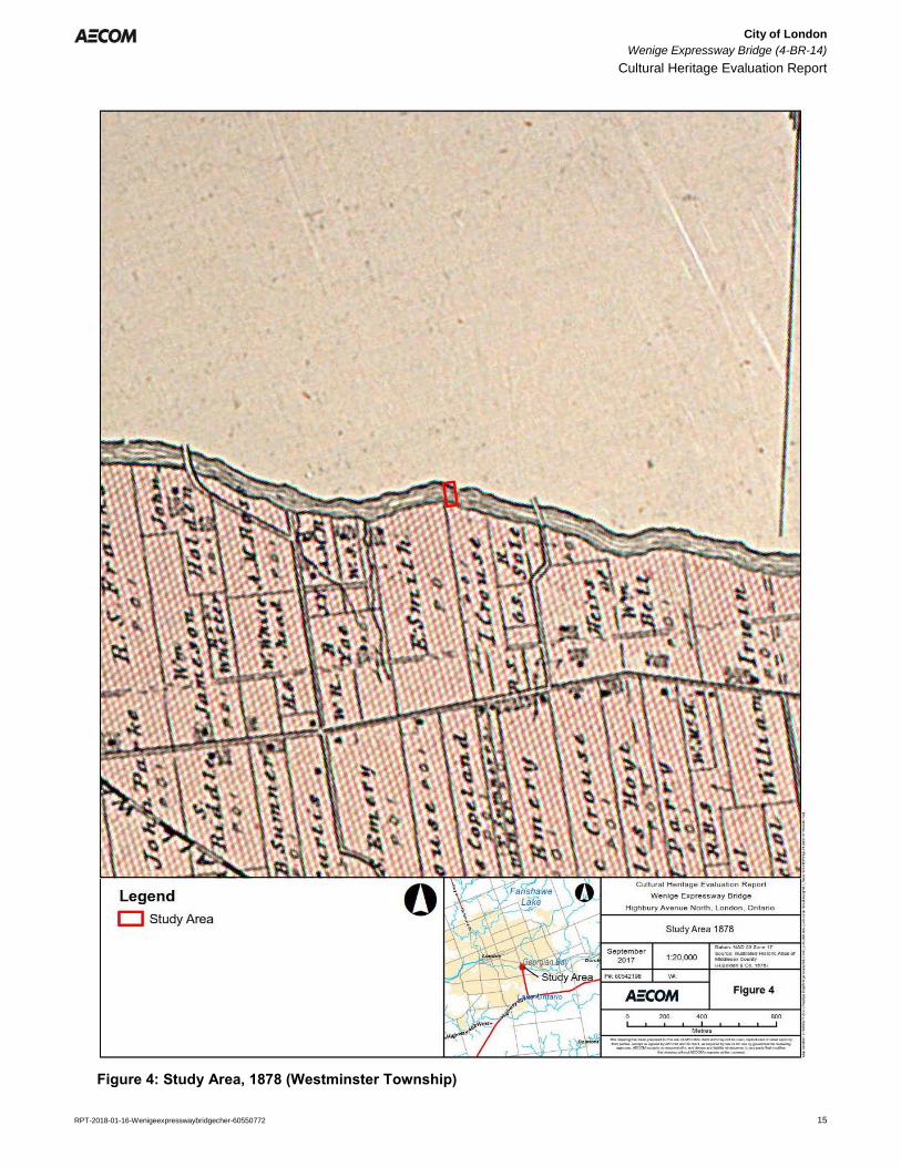
develop. South of the river, the lots appear to not have been subdivided yet and were likely still agricultural or
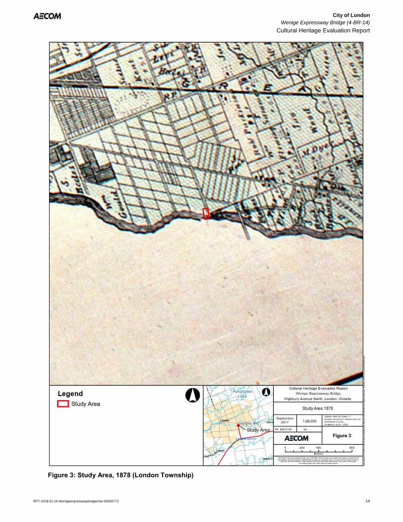
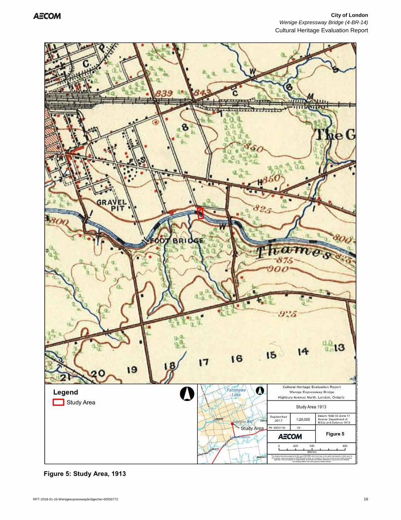
wooded in use (Figure 3 and Figure 4). By 1913, the area north of the bridge was starting to be developed,
specifically along Hamilton Road, while the area south of the river was undeveloped. Highbury Avenue still
terminated at the river. A side road – what is now Norlan Avenue – connected Highbury Avenue with Meadowlily
Road to the east where a truss bridge crossed the river (Figure 5).
By the middle of the 20th century, growth from the City of London had extended significantly to the east where the
areas surrounding the subject bridge was mostly developed. North of the river, subdivisions were developed along
the north and south sides of Hamilton Road, and the Highbury Transformer Station had been constructed with
transmission corridors crossing the river. South of the river, isolated structures were present along Meadowlily
Road and Commissioners Road respectively. However, Highbury Avenue had still yet to be extended across the
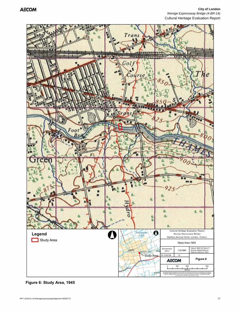
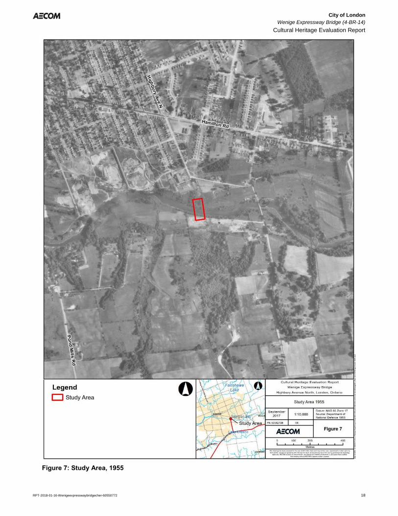
river and thus little development had taken place within the study area south of the river (Figure 6). Aerial
photography from 1955 confirms the development depicted on the historic topographic mapping in the early and
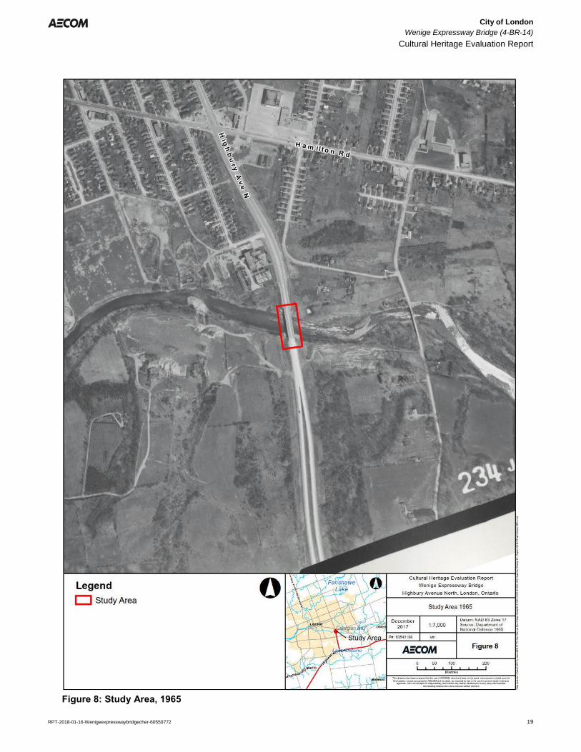
mid-20th century (Figure 7). The road would not be extended across the river to Highway 401 until the 1960s. In
addition, the area surrounding the bridge was not officially annexed with the City of London until 1961.
3.2.2 Park Farm Property
The property located at 120 Meadowlily Road South, approximately 600m to the east, otherwise known as Park
Farm is an important cultural heritage landscapes within the City of London. The residential building on the property
was constructed for William Bell, an English farmer who arrived in Canada in the area in the 1850s. In 1907, the
property came into the ownership of Maxwell David Fraser, and eventually turned into a prosperous dairy farm by
his son, Harrison Fraser, a prominent barrister and solicitor in the family firm of Fraser and Fraser. The Fraser
family promoted the use of their property by the citizens of London for recreational purposes because of its natural
beauty along the river. The property was eventually willed to the City of London to be used continuously as a public
recreation space.2
Today, the property is now part of Meadowlily Park and was designated under Part IV of the Ontario Heritage Act in
1995.3 The property is composed of a residence, shed, and grounds set on a wooded hill with a panoramic view of
the surrounding natural areas.
3.2.3 Stevenson Camp/Thames Talbot Land Trust
Prior to the extension of Highbury Avenue south of the Thames River, the surrounding property was once the site of
the Stevenson Camp, a property used by the London Children’s Aid Society (CAS). In 1947, Dr. W.J. Stevenson
bequeathed 300 acres to the London CAS in memory of high brother Dr. Hugh A. Stevenson, in order to
established a playground/camp on the property. By 1949, a partnership between the London CAS and the London
Kinsmen Club commenced work on the camp which consisted of 100 acres for facilities, and 200 acres for hiking
and nature study. According to Stevenson’s will, the camp was to be used “for the benefit of underprivileged
children who would otherwise not experience a summer holiday out of the city.” In the 1950s, the camp operated
for a short period on the property and its facilities grew to include six sleeping cabins, a main lodge, a craft house, a
2 Park Farm, 120 Meadowlily Road South, London, Ontario, http://www.historicplaces.ca/en/rep-reg/place-lieu.aspx?id=11881
(accessed December 2017). 3 City of London, By-law L.S.P.-3253-58).
City of London
Wenige Expressway Bridge (4-BR-14)
Cultural Heritage Evaluation Report
RPT-2018-01-16-Wenigeexpresswaybridgecher-60550772 10
director’s cabin, a washroom/shower facility, and a 20 x 40 foot pool. However, by 1955 the Stevenson Camp had
moved to Dorchester, and by the 1960s the Highbury Avenue Extension cut directly through the property.
In 2002, a portion of the property was donated by Carol and Rick Richardson to the citizens of London. The 59
hectares of land is now known as the Meadowlily Nature Preserve and is managed by the Thames Talbot Land
Trust, a non-profit organization dedicated to protecting environmentally significant lands in Southwestern Ontario.
3.2.4 Highbury Avenue/Highway 126/Wenige Expressway
Highbury Avenue, north of the river was laid out as a part of the London Township survey. The road remained an
early north-south concession road east of the City well into the 20th century. As noted above, the area did not see
significant development until the mid-20th century when the City’s growth stretched east, most notably along
Hamilton Road within the vicinity of the subject river crossing. However, it wasn’t until the 1950s and 1960s that
plans and designs to extend Highbury Avenue across the Thames River were realized.
In 1958, a Highbury Avenue overpass was constructed to carry the road over the Canadian Pacific Railway (CPR)
tracks, well north of the river. Although not directly associated with the extension of Highbury Avenue and the
crossing of the Thames River, this project was noted as being a key component to the future of Highbury Avenue
as a main traffic route in London. An article in the London Free Press (Free Press) following the completion of the
overpass noted, “Opening of the new Highbury Avenue overpass completes a major step in long-range plans for
making Highbury a key by-pass route in the London area. If and when plan goes through for extending Highbury
southward to meet No. 401 Highway, it will be a fast through route for a large volume of traffic wishing to skirt
London.”4
Plans for the extension of Highbury Avenue were put into action beginning in the early-1960s. By October 1962, the
Free Press published an article noting that all of the necessary properties needed for the extensions were
expropriated and now vacant. It was also noted that the another overpass was being built at the Canadian National
Railway (CNR) tracks and the opening was planned to coincide with the opening of the river crossing so that the
extension would be complete to Highway 401 all at once. Construction took place throughout 1962 and 1963 and
by December of 1963, the extension was opened.5
Much like the CPR overpass, the CNR overpass was also celebrated as being a key component of the extension.
On December 9th, 1963 a bridge opening ceremony was held at the CNR overpass where Mayor Stronach, and
John White, a MPP for London South, along with a group of CNR, City, and provincial officials cut a ribbon then
proceeded to form an official motorcade that travelled the route south to Highway 401. The motorcade passed
through the cloverleaf at Highway 401 to “officially” open the Highbury extension. Much of the focus on the opening
of the extension was on the CNR overpass and the Highway 401 cloverleaf with a minor mention of a bridge being
constructed over the Thames River as a part of the project.6
The naming of the Highbury extension has taken on various titles throughout its short history. Originally described
publically as the Highbury extension, the naming of the extension was a subject of debate between the City of
London and the Province of Ontario throughout the 1960s and 1970s. In 1963, the City Council adopted a
recommendation to formally name the extension the Wenige Expressway, after the late mayor George A. Wenige,
a popular London mayor throughout the first half of the 20th century. Nonetheless, the Department of Highways or
DHO (currently known as the Ministry of Transportation of Ontario, MTO) rejected the name citing safety as the
main reason. At the time, Highbury Avenue south to Power Street was owned by the City. However, from Power
Street south across the Thames River to Highway 401 was owned by the DHO which preferred a numbered
4 “Traffic Artery Widened to Four Lanes,” London Free Press, February 5, 1958. 5 “All Properties for Extension Now Vacated,” London Free Press, October 29, 1962; DHO Annual Reports, 1962-1964. 6 “Highbury Overpass Opened.,” London Free Press, December 9, 1963.
City of London
Wenige Expressway Bridge (4-BR-14)
Cultural Heritage Evaluation Report
RPT-2018-01-16-Wenigeexpresswaybridgecher-60550772 11
highway name, in this case Highway 126. An engineer for the Province noted that a numbered highway name
would be consistent with the Province’s numbering of highways and for safety would be larger on signage making it
more visible from farther away.7
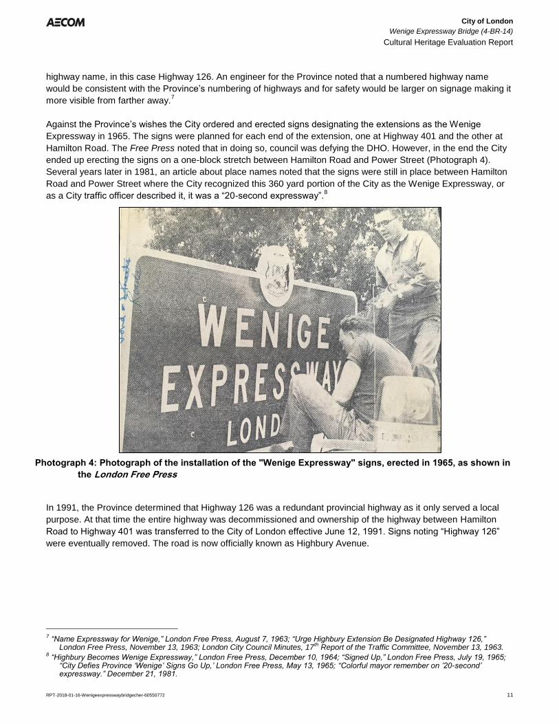
Against the Province’s wishes the City ordered and erected signs designating the extensions as the Wenige
Expressway in 1965. The signs were planned for each end of the extension, one at Highway 401 and the other at
Hamilton Road. The Free Press noted that in doing so, council was defying the DHO. However, in the end the City
ended up erecting the signs on a one-block stretch between Hamilton Road and Power Street (Photograph 4).
Several years later in 1981, an article about place names noted that the signs were still in place between Hamilton
Road and Power Street where the City recognized this 360 yard portion of the City as the Wenige Expressway, or
as a City traffic officer described it, it was a “20-second expressway”.8
In 1991, the Province determined that Highway 126 was a redundant provincial highway as it only served a local
purpose. At that time the entire highway was decommissioned and ownership of the highway between Hamilton
Road to Highway 401 was transferred to the City of London effective June 12, 1991. Signs noting “Highway 126”
were eventually removed. The road is now officially known as Highbury Avenue.
7 “Name Expressway for Wenige,” London Free Press, August 7, 1963; “Urge Highbury Extension Be Designated Highway 126,”
London Free Press, November 13, 1963; London City Council Minutes, 17th Report of the Traffic Committee, November 13, 1963. 8 “Highbury Becomes Wenige Expressway,” London Free Press, December 10, 1964; “Signed Up,” London Free Press, July 19, 1965;
“City Defies Province ‘Wenige’ Signs Go Up,’ London Free Press, May 13, 1965; “Colorful mayor remember on ’20-second’ expressway.” December 21, 1981.
Photograph 4: Photograph of the installation of the "Wenige Expressway" signs, erected in 1965, as shown in
the London Free Press
City of London
Wenige Expressway Bridge (4-BR-14)
Cultural Heritage Evaluation Report
RPT-2018-01-16-Wenigeexpresswaybridgecher-60550772 12
3.2.5 George Wenige
George Wenige was born in Detroit in 1874 and arrived in London in 1899. Wenige started his career as a brush
salesman; however, he made his name for himself in London as a bicycle business owner and trick bicycle rider.
He opened a bicycle shop in London and was at one time reported to have owned the largest bicycle agency in
Canada. He also entered into the world of local politics, first becoming an alderman in 1921. He ran as a mayoral
candidate on 20 occasions and was successful on 9 of them, serving terms in 1923-1925, 1928, 1934-1935, 1947-
1948, and 1950. He has become known as one of the most outgoing mayors in London’s history as a result of his
interests in people and entertainment. In addition, in his political career he commonly used city-wide referendums,
and he is known for streamlining city committees, the Fire Department, providing incentive pay for good city
workers, as well as for cutting costs at Victoria Hospital. He also played a role in improving the Western Fair,
getting a new Canadian National Railway Station in London, and in expanding Parkwood Hospital. The Wenige
Expressway was posthumously named after him.9
3.2.6 Bridge Building Context
Most original public highway bridges were built and owned by a municipality such as a county, town or a township.
Much more rarely, they were owned by the Province. Matters pertaining to bridge ownership have been dictated by
the Ontario Municipal Act since 1867. The construction and operation of bridges over water courses that formed
boundaries between townships were always assumed by an upper level of government, such as a County.
Most 19th-century bridges in southern Ontario were built of timber. Short spans were beam structures; longer
spans employed simple trusses, such as King and Queen Post trusses. A few iron truss bridges were built in the
1870s-1880s but were generally too costly to be widely used. Two well-known iron bridges, an earlier version of the
current Victoria Bridge, and the well-known Blackfriar’s Bridge were built within London.
The economic value to communities of good roads, and by extension good bridges, was becoming evident.
Nineteenth-century wooden bridges could not carry the weight of heavier wagon and street railway equipment
coming into use. By the First World War, motor vehicles were becoming increasingly common and the provincial
government began to provide grant programs and technical advice on bridge building. At the same time, counties
began to create county-wide road networks by assuming the ownership of key township roads and bridges.
Inexpensive steel trusses came into use in the 1890s and the designs were commonly used into the 1930s. The
Pratt truss and the Warren truss dominated the early-20th century, and were typically used for spans of up to 400
feet. The Meadowlily Bridge and the King Street Bridge are both steel truss bridges constructed within London.
Both bridges are have been rehabilitated recently and are currently being used as footbridges.
At the beginning of the 20th century concrete became widely used to construct short span bridges. One of the
earliest forms was the solid spandrel concrete arch design that was inexpensive to build. This design consisted of
solid concrete spandrel walls that held back the stone rubble and earth fill on the interior of the arch. The arch itself
was constructed with reinforcing steel bars. By the 1930s, concrete challenged steel as the primary bridge-building
material of choice and various concrete bridges types have since been used for road bridge construction.
3.2.7 Wenige Expressway Bridge
As noted in the subsections above, prior to the 1960s, Highbury Avenue terminated at the Thames River. However,
with the extension of Highbury Avenue south to Highway 401, the Wenige Expressway Bridge was constructed in
9 George A. Armstrong, The Forest City: An Illustrated History of London, Canada, Windsor: Windsor Publications, 1986.
City of London
Wenige Expressway Bridge (4-BR-14)
Cultural Heritage Evaluation Report
RPT-2018-01-16-Wenigeexpresswaybridgecher-60550772 13
order to carry the road over the Thames River. The bridge was designed internally by DHO engineers in 1960 as
part of the planning for the Highbury Avenue extension. As a result, little biographical information related the bridge
designers or engineers could be determined. In addition, the contractor for construction of the bridge has not been
determined.
The bridge was completed in 1963, and opened as part of the Highbury Avenue extension. Based on the original
design drawings, routine maintenance and rehabilitation activities have taken place since construction. The most
notable rehabilitation was a recoating of all structural steel on the bridge in 1990. Aside from the installation of
concrete barriers on the deck of the bridge, the structure has not changed in appearance from its original
construction in 1963.
City of London
Wenige Expressway Bridge (4-BR-14)
Cultural Heritage Evaluation Report
RPT-2018-01-16-Wenigeexpresswaybridgecher-60550772 14
Figure 3: Study Area, 1878 (London Township)
City of London
Wenige Expressway Bridge (4-BR-14)
Cultural Heritage Evaluation Report
RPT-2018-01-16-Wenigeexpresswaybridgecher-60550772 15
Figure 4: Study Area, 1878 (Westminster Township)
City of London
Wenige Expressway Bridge (4-BR-14)
Cultural Heritage Evaluation Report
RPT-2018-01-16-Wenigeexpresswaybridgecher-60550772 16
Figure 5: Study Area, 1913
City of London
Wenige Expressway Bridge (4-BR-14)
Cultural Heritage Evaluation Report
RPT-2018-01-16-Wenigeexpresswaybridgecher-60550772 17
Figure 6: Study Area, 1945
City of London
Wenige Expressway Bridge (4-BR-14)
Cultural Heritage Evaluation Report
RPT-2018-01-16-Wenigeexpresswaybridgecher-60550772 18
Figure 7: Study Area, 1955
City of London
Wenige Expressway Bridge (4-BR-14)
Cultural Heritage Evaluation Report
RPT-2018-01-16-Wenigeexpresswaybridgecher-60550772 19
Figure 8: Study Area, 1965
City of London
Wenige Expressway Bridge (4-BR-14)
Cultural Heritage Evaluation Report
RPT-2018-01-16-Wenigeexpresswaybridgecher-60550772 20
4. Site Description
4.1 Context
The Wenige Expressway Bridge is a two-span steel plate girder structure, supported on concrete abutments and a
centre concrete pier. The structure carries Highbury Avenue over the South Branch of the Thames River, in
London, Ontario (Photographs 5 and 6).
4.2 Cultural Landscape
At the site of the bridge, Highbury Avenue South is a four lane freeway at the bridge, running in a north-south
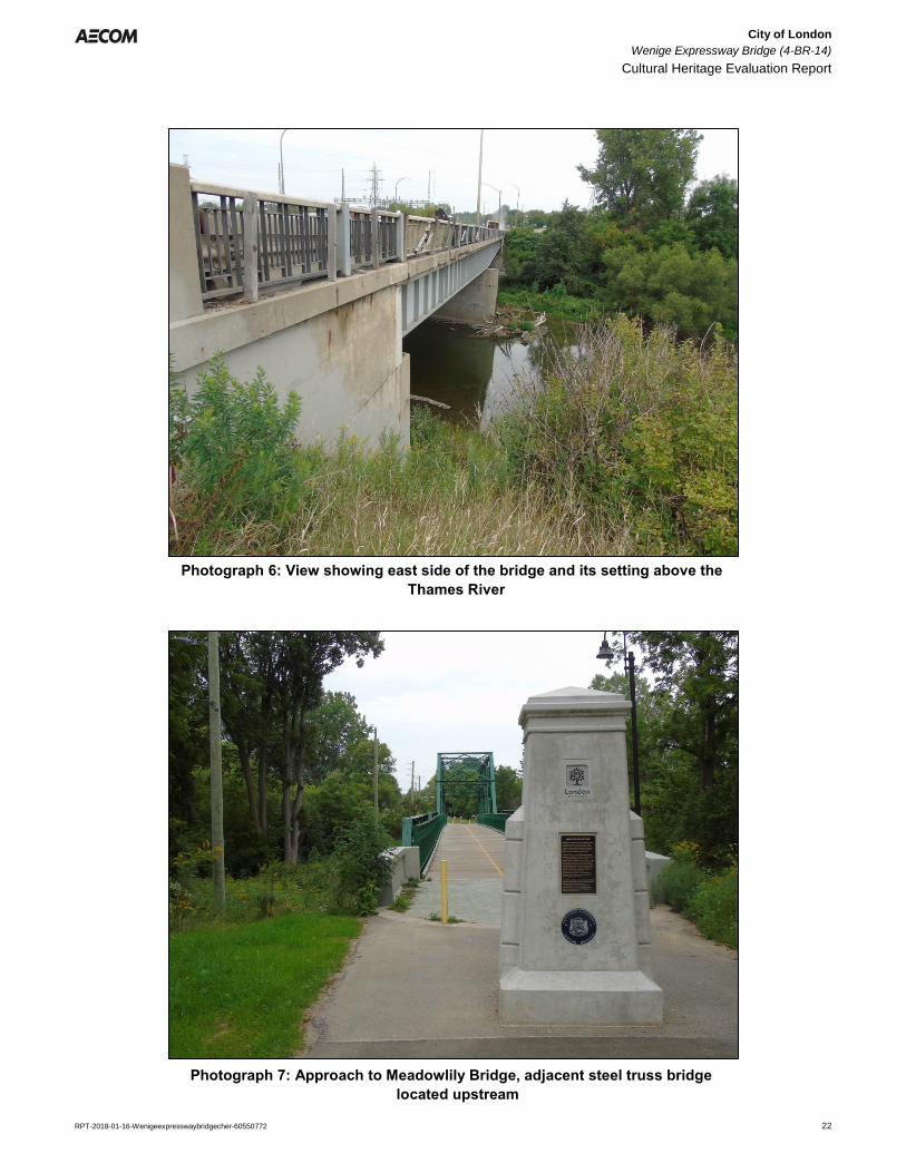
orientation and provides access to Highway 401 south of the bridge. Historically, a bridge crossing at this location
was not built until 1963 when Highbury Avenue was extended south across the river. Prior to its construction, the
closest crossing of the river was the Meadowlily Bridge, located approximately 350 m to the east, upstream of the
Wenige Expressway Bridge (Photographs 7 and 8). The Vauxhaull Bridge, carrying Thompson Road/Egerton Street
over the Thames is closest westerly crossing of the river, located approximately 4 km to the west.
At the bridge, the physical landscape consists of a relatively wide valley with moderately steep valley walls. The
river flows through a wide channel with moderately sloped banks lined with large concrete blocks to the east. A
concrete pier is located in the centre of the river to support the bridge. At the time of the field investigation water
levels in the river were low east of the pier. The east and west banks of the river are lined with vegetation.
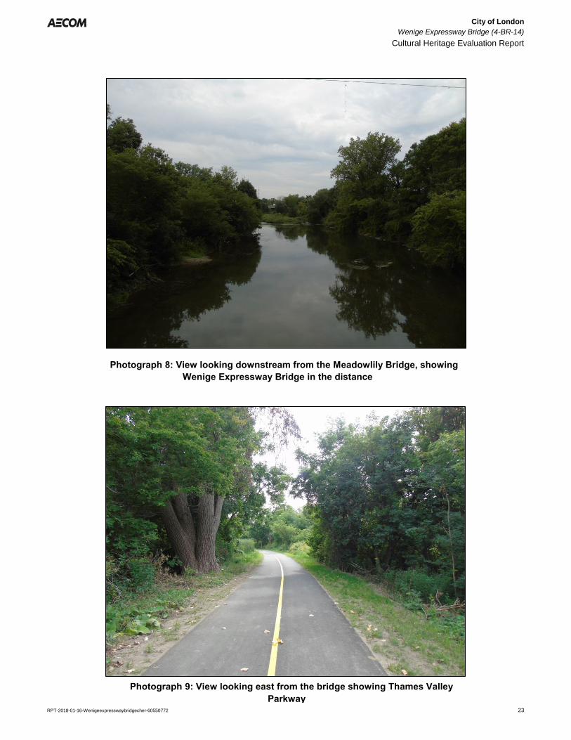
Formal and informal trails are located on north and south banks of the river. North of the river, the Thames Valley
Parkway (TVP) trail passes under the bridge. The paved parkway is a pedestrian and cyclist trail network that
weaves throughout the City. To the east, the trail leads to Potterburg Park and to the west it leads follows the river
to the Forks and points northward. South of the river, an informal trail can be accessed from Meadowlily Road and
extends through a wooded area, through an open meadow just southeast of the bridge. St. Julien Park and
Shelborne Park are also located north and south of river respectively (Photographs 9 – 12).
4.3 Approaches
Both approaches to the bridge are relatively level and are generally consistent with the grading of the road at the
bridge. North of the bridge, the road curves slightly and a slight incline in the road is evident as the road
approaches the bridge, however at the bridge structure the approach is generally flat (Photograph 13).
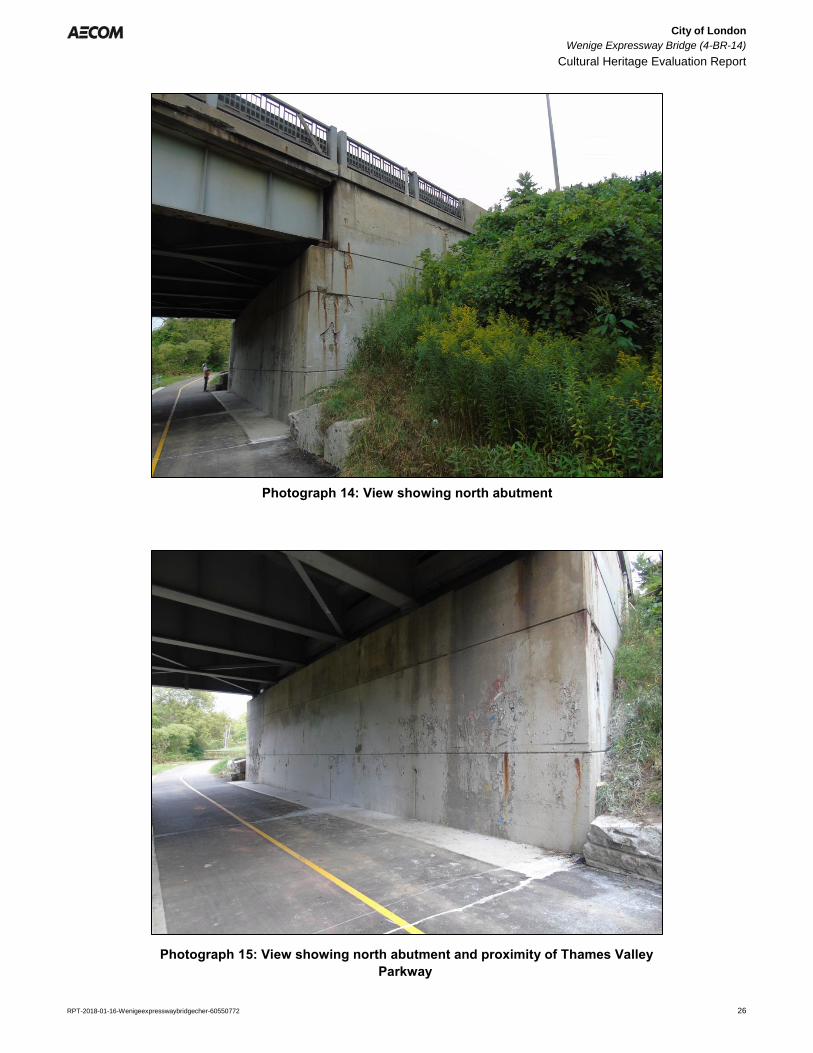
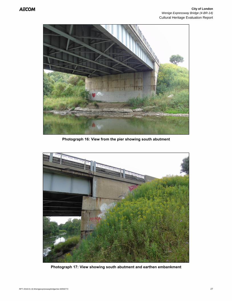
4.4 Abutments and Piers
The north and south abutments are constructed of cast-in-place concrete and are built into the tall earth
embankments to raise the bridge to the grade level of Highbury Avenue. The TVP is located immediately adjacent
to the north abutment, and remnants of paint layers can be seen on the smooth face of the concrete. Drainage
holes are also visible in the abutment wall. Large concrete wingwalls are situated on the east and west sides of the
abutment where the trail meets the steep embankment. The south abutment is constructed closer to the river bank,
however, an informal trail also passes under the bridge, immediately adjacent to the abutment. A concrete pier is
City of London
Wenige Expressway Bridge (4-BR-14)
Cultural Heritage Evaluation Report
RPT-2018-01-16-Wenigeexpresswaybridgecher-60550772 21
also located in the centre of the river. The ends of the pier are rounded to deflect the flow of the river, however, the
pier appears to still catch large debris such as logs (Photographs 14 – 18).
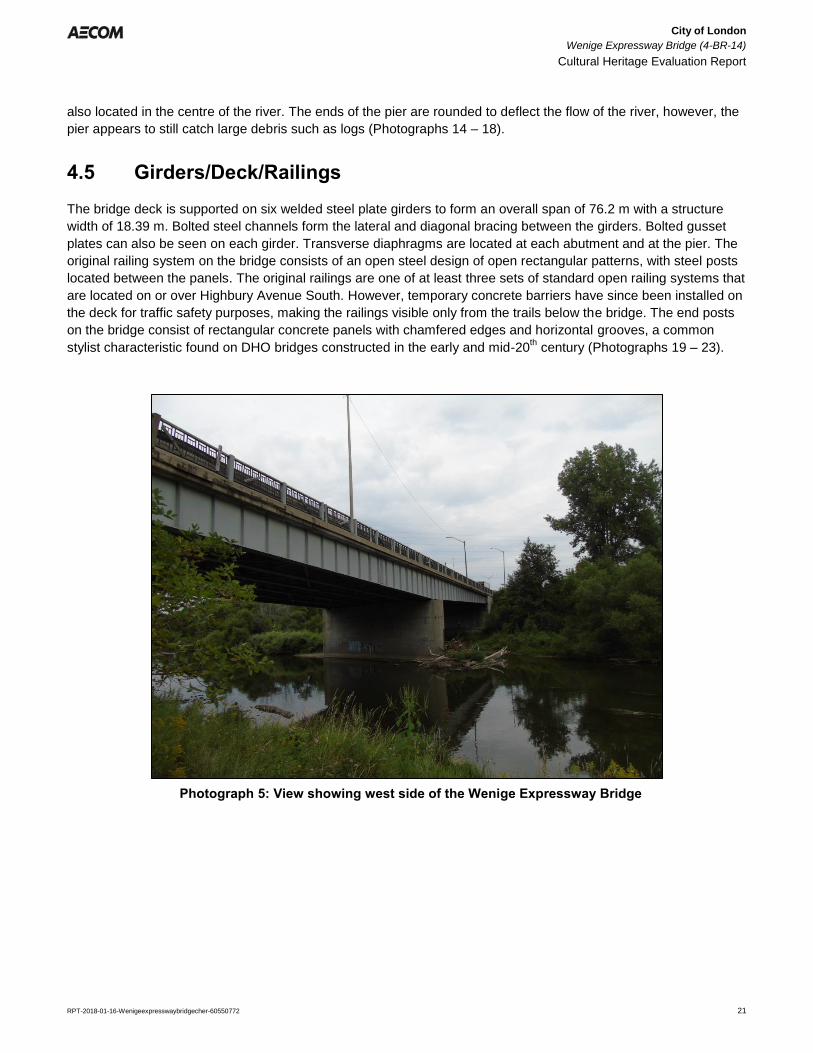
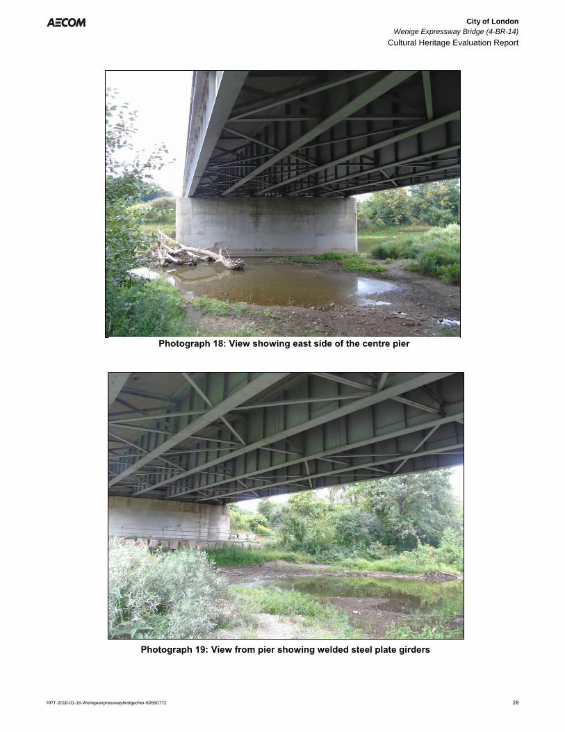
4.5 Girders/Deck/Railings
The bridge deck is supported on six welded steel plate girders to form an overall span of 76.2 m with a structure
width of 18.39 m. Bolted steel channels form the lateral and diagonal bracing between the girders. Bolted gusset
plates can also be seen on each girder. Transverse diaphragms are located at each abutment and at the pier. The
original railing system on the bridge consists of an open steel design of open rectangular patterns, with steel posts
located between the panels. The original railings are one of at least three sets of standard open railing systems that
are located on or over Highbury Avenue South. However, temporary concrete barriers have since been installed on
the deck for traffic safety purposes, making the railings visible only from the trails below the bridge. The end posts
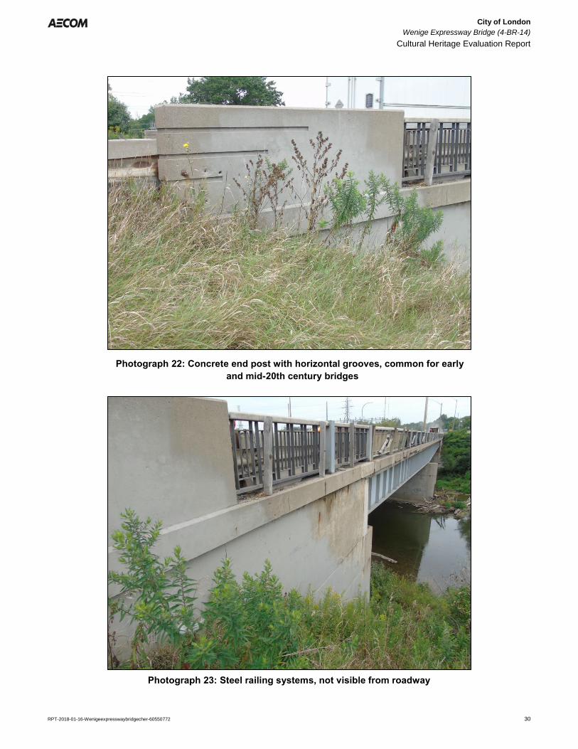
on the bridge consist of rectangular concrete panels with chamfered edges and horizontal grooves, a common
stylist characteristic found on DHO bridges constructed in the early and mid-20th century (Photographs 19 – 23).
Photograph 5: View showing west side of the Wenige Expressway Bridge
City of London
Wenige Expressway Bridge (4-BR-14)
Cultural Heritage Evaluation Report
RPT-2018-01-16-Wenigeexpresswaybridgecher-60550772 22
Photograph 6: View showing east side of the bridge and its setting above the n n
n Thames River
Photograph 7: Approach to Meadowlily Bridge, adjacent steel truss bridge n
n located upstream
City of London
Wenige Expressway Bridge (4-BR-14)
Cultural Heritage Evaluation Report
RPT-2018-01-16-Wenigeexpresswaybridgecher-60550772 23
Photograph 8: View looking downstream from the Meadowlily Bridge, showing n
n Wenige Expressway Bridge in the distance
Photograph 9: View looking east from the bridge showing Thames Valley
n Parkway
City of London
Wenige Expressway Bridge (4-BR-14)
Cultural Heritage Evaluation Report
RPT-2018-01-16-Wenigeexpresswaybridgecher-60550772 24
Photograph 10: View looking east towards bridge from Thames Valley Parkway
Photograph 11: View looking south from Highbury Avenue showing meadow
h and informal trail at left
City of London
Wenige Expressway Bridge (4-BR-14)
Cultural Heritage Evaluation Report
RPT-2018-01-16-Wenigeexpresswaybridgecher-60550772 25
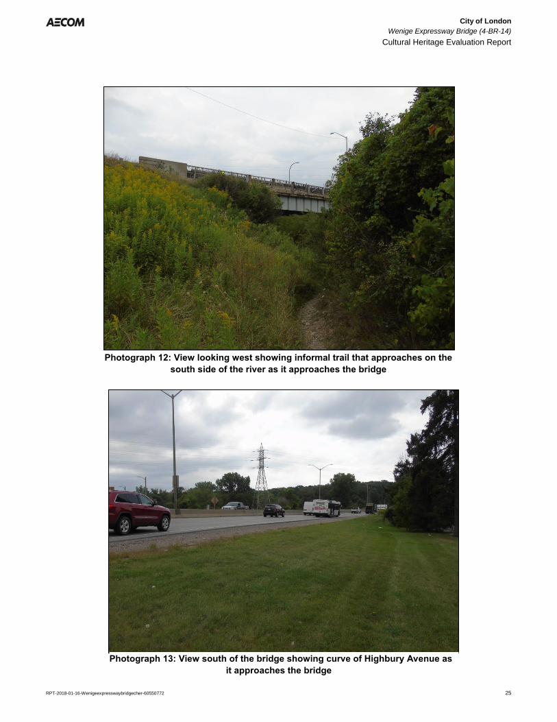
Photograph 12: View looking west showing informal trail that approaches on the
n south side of the river as it approaches the bridge
Photograph 13: View south of the bridge showing curve of Highbury Avenue as
n it approaches the bridge
City of London
Wenige Expressway Bridge (4-BR-14)
Cultural Heritage Evaluation Report
RPT-2018-01-16-Wenigeexpresswaybridgecher-60550772 26
Photograph 14: View showing north abutment
Photograph 15: View showing north abutment and proximity of Thames Valley
n Parkway
City of London
Wenige Expressway Bridge (4-BR-14)
Cultural Heritage Evaluation Report
RPT-2018-01-16-Wenigeexpresswaybridgecher-60550772 27
Photograph 16: View from the pier showing south abutment
Photograph 17: View showing south abutment and earthen embankment
City of London
Wenige Expressway Bridge (4-BR-14)
Cultural Heritage Evaluation Report
RPT-2018-01-16-Wenigeexpresswaybridgecher-60550772 28
Photograph 18: View showing east side of the centre pier
Photograph 19: View from pier showing welded steel plate girders
City of London
Wenige Expressway Bridge (4-BR-14)
Cultural Heritage Evaluation Report
RPT-2018-01-16-Wenigeexpresswaybridgecher-60550772 29
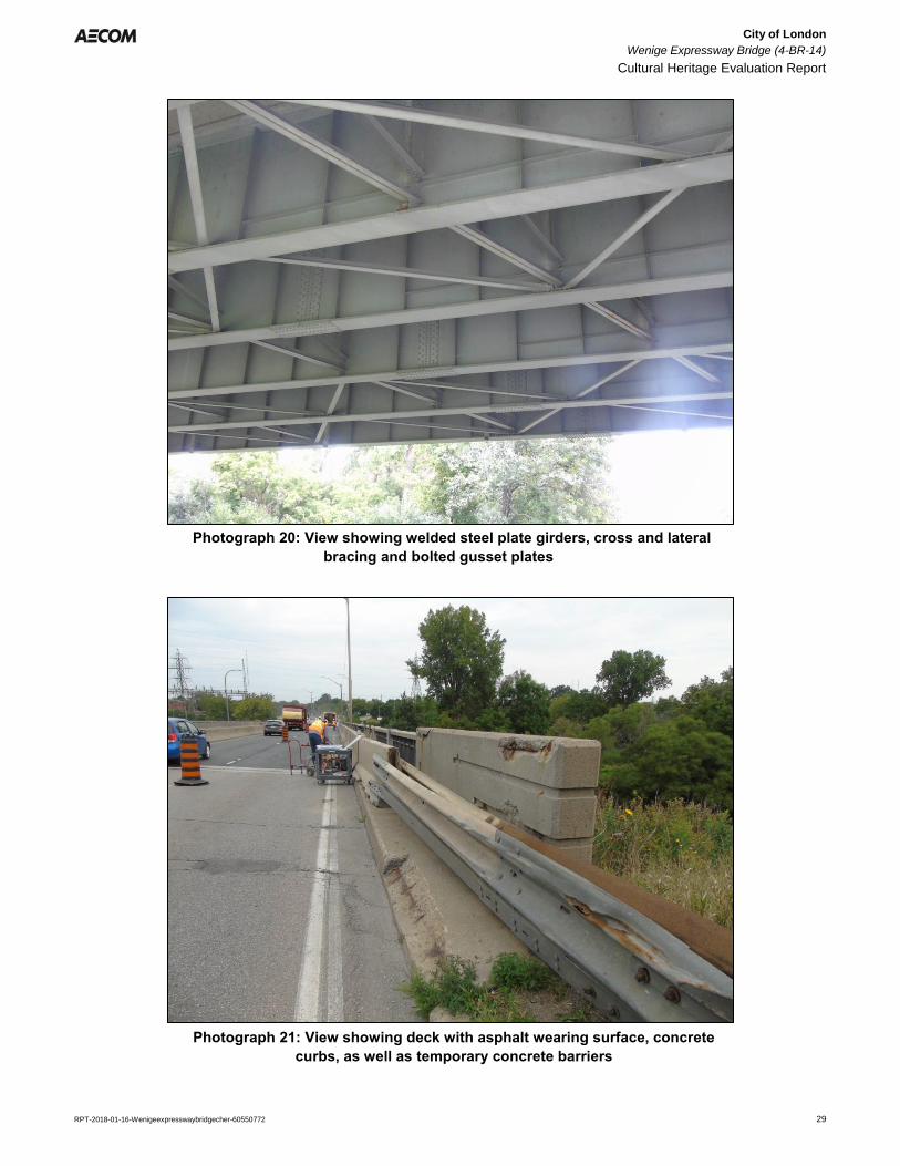
Photograph 20: View showing welded steel plate girders, cross and lateral n
n bracing and bolted gusset plates
Photograph 21: View showing deck with asphalt wearing surface, concrete n
n curbs, as well as temporary concrete barriers
City of London
Wenige Expressway Bridge (4-BR-14)
Cultural Heritage Evaluation Report
RPT-2018-01-16-Wenigeexpresswaybridgecher-60550772 30
Photograph 22: Concrete end post with horizontal grooves, common for early
n and mid-20th century bridges
Photograph 23: Steel railing systems, not visible from roadway
City of London
Wenige Expressway Bridge (4-BR-14)
Cultural Heritage Evaluation Report
RPT-2018-01-16-Wenigeexpresswaybridgecher-60550772 31
5. Evaluation
5.1 Ontario Regulation 9/06
Ontario Regulation 9/06 provides criteria for determining cultural heritage value or interest. If a property meets one
or more of the following criteria it may be designated under Section 29, Part IV of the Ontario Heritage Act. The
criteria for determining cultural heritage value under Ontario Regulation 9/06 have been adopted by City of London
and are outlined below:
1) The property has design or physical value because it:
Is a rare, unique, representative or early example of a style, type, expression, material or construction
method;
Displays a high degree of craftsmanship or artistic merit; or
Demonstrates a high degree of technical or scientific achievement.
2) The property has historic or associative value because it:
Has direction associations with a theme, event, belief, person, activity, organization, or institution that is
significant to a community;
Yields, or has the potential to yield information that contributes to an understanding of a community or
culture; or
Demonstrates or reflects the work or ideas of an architect, artist, builder, designer, or theorist who is
significant to a community.
3) The property has contextual value because it:
Is important in defining, maintaining, or supporting the character of an area;
Is physically, functionally, visually, or historically linked to its surroundings; or
Is a landmark.
The application of the criteria for the evaluation of the Wenige Expressway Bridge is provided below in Table .
Table 1: Ontario Regulation 9/06 Evaluation for the Wenige Expressway Bridge
Criteria Meets Criteria
(Yes/No)
Rationale
1) The property has design or physical value because
it:
i) Is a rare, unique, representative or
early example of a style, type,
expression, material or construction
method.
No The Wenige Expressway Bridge is a two-span steel
plate girder structure on concrete abutment. It is of
common 20th century bridge design and construction.
The standard railing systems were and still are
typically used on DHO/MTO bridges, however, they
are becoming increasingly rare. Within London, there
are at least three bridges with similar open railing
systems along Highbury Avenue South. Nonetheless,
the bridge is not a rare, unique, or representative
example of a style, type, expression, material, or

City of London
Wenige Expressway Bridge (4-BR-14)
Cultural Heritage Evaluation Report
RPT-2018-01-16-Wenigeexpresswaybridgecher-60550772 32
construction method.
ii) Displays a high degree of
craftsmanship or artistic merit.
No The Wenige Expressway Bridge is a two-span steel
plate girder structure on concrete abutment. The
bridge does not display a high degree of
craftsmanship or artistic merit.
iii) Demonstrates a high degree of
technical or scientific achievement.
No The Wenige Expressway Bridge is a common bridge
form and design and does not demonstrate a high
degree of technical or scientific achievement.
2) The property has historic value or associate value
because it:
i) Has direct associations with a
theme, event, belief, person, activity,
organization, or institution that is
significant to a community.
No The Wenige Expressway Bridge was constructed as a
part of the Highbury Avenue extension in the 1960s.
Although constructed as a part of the extension
undertaken by the City and the Province, the bridge
does not have historic or associative value as a result
of its role in the extension. In addition, the Wenige
Expressway and therefore the subject bridge were
named posthumously for George Wenige, former
mayor of London. Although named after the former
mayor, the association with Wenige is not enough to
result in significant cultural heritage value.
ii) Yields, or has the potential to yield
information that contributes to an
understanding of a community or
culture.
No The Wenige Expressway Bridge does not yield or
have the potential to yield information that contributes
to an understanding of a community or culture.
iii) Demonstrates or reflects the work
or ideas of an architect, artist, builder,
designer, or theorist who is significant
to a community.
No The Wenige Expressway Bridge was designed
internally at the DHO and is a relatively common
design of a steel plate girder structure.
3) The property has contextual value because it:
i) Is important in defining, maintaining
or supporting the character of an area.
No The Wenige Expressway Bridge carries Highbury
Avenue over the Thames River and the TVP. In this
way, it plays a role in defining the landscape of the
TVP, however, the crossing of the river at this location
is not a significant contribution in defining, maintain, or
supporting a particular character of an area.
ii) Is physically, functionally, visually or
historically linked to its surroundings.
No The Wenige Expressway Bridge is a key crossing of
the Thames River that was built to extend Highbury
Avenue south to Highway 401. However, the bridge
itself is not physically, functionally, visually, or
historically linked to its surroundings in manner that
would result in significant cultural heritage value.
iii) Is a landmark. No The Wenige Expressway Bridge is not considered a
landmark.
5.2 Review of Heritage Registers and Additional Information
As a part of the evaluation undertaken for this CHER, AECOM reviewed municipal, provincial, and federal heritage
registers and inventories including:
City of London
Wenige Expressway Bridge (4-BR-14)
Cultural Heritage Evaluation Report
RPT-2018-01-16-Wenigeexpresswaybridgecher-60550772 33
City of London, Inventory of Heritage Resources (2006);
Ontario Heritage Trust’s online inventory of buildings, museums, and easement properties;
Canadian Register of Historic Places; and
Federal Heritage Designations.
As a two-span steel plate girder structure, the bridge is a common form and type of bridge found not only
throughout London but also across Ontario. Constructed of concrete, with steel girders and railings, the structure is
a common example of mid-20th century bride construction found in Southwestern Ontario.
Lastly, the Thames River is a designated river as part of the Canadian Heritage Rivers System (CHRS). The CHRS
is a conservation program that promotes, protects, and enhances Canada’s river heritage and ensure that
Canada’s leading rivers are sustainably managed. As part of the designation application and the on-going
monitoring and reporting for the Thames River, a series of publications have been developed to preserve and
enhance the natural and cultural heritage of the river.
City of London
Wenige Expressway Bridge (4-BR-14)
Cultural Heritage Evaluation Report
RPT-2018-01-16-Wenigeexpresswaybridgecher-60550772 34
6. Recommendations
At the time of the preparation, there is no specific proposed undertaking, however, the design report being
undertaken concurrently is anticipated to provide recommendations for rehabilitation activities for the bridge.
Nonetheless, when evaluated according to the criteria outlined in Ontario Regulation 9/06, Criteria for Determining
Cultural Heritage Value or Interest, the bridge did not meet any of the criteria. As a result, the Wenige Expressway
Bridge does not contain cultural heritage value and thus a Statement of Cultural Heritage Value and a list of
Heritage Attributes were not developed. No further reporting related to cultural heritage is recommended for this
structure.
City of London
Wenige Expressway Bridge (4-BR-14)
Cultural Heritage Evaluation Report
RPT-2018-01-16-Wenigeexpresswaybridgecher-60550772 35
7. Bibliography
Armstrong, Frederick H. The Forest City: An Illustrated History of London, Canada. Windsor. Windsor Publications,
Ltd. 1986.
Bremner, Arnold. City of London, Ontario Canada: The Pioneer Period and the London of Today. London: London
Printing and Lithographing Company Ltd. 1900.
Dean, W.G. Economic Atlas of Ontario. Toronto: University of Toronto Press, 1969.
Department of Lands and Forests. Aerial Photography. London. 1:15,700. 4244. 85. 1955.
Illustrated Historical Atlas of the County of Middlesex. Toronto: H.R. Page and Co., 1878.
London, City of. City of London Inventory of Heritage Resources. The London Advisory Committee on Heritage.
Department of Planning and Development. 2006.
London Free Press. 1950-1981.
National Topographic Series. 40 I/14. St. Thomas. 1913. National Topographic Series. 40 I/14. St. Thomas. 1945. Parks Canada. Canadian Register of Historic Places. www.historicplaces.ca (accessed October 2017).

aecom.com