Embed Size (px)
Citation preview
Cultural Resources Investigations of the Univision Texas Property in Bexar County, Texas
Prepared for
UNV TEXAS, LP
Prepared by
Laura I. Acuña and Mary Jo Galindo
SWCA Cultural Resources Report No. 12-327 July 2012
CULTURAL RESOURCES INVESTIGATIONS OF THE UNIVISION TEXAS
PROPERTY IN BEXAR COUNTY, TEXAS
Prepared for
UNV TEXAS, LP
500 Frank W. Burr Blvd., Suite 19 Teaneck, New Jersey 07666
Prepared by
Laura I. Acuña and Mary Jo Galindo
SWCA ENVIRONMENTAL CONSULTANTS
6200 UTSA Boulevard, Suite 102
San Antonio, Texas 78249
www.swca.com
Principal Investigator
Kevin A. Miller
SWCA Project Number 23527-SAN
SWCA Cultural Resources Report No. 12-327
July 31, 2012

i
ABSTRACT
On behalf of UNV Texas, LP, Inc., SWCA Environmental Consultants (SWCA) conducted an
intensive cultural resource survey of a 4.5-acre parcel in Bexar County, Texas. The investigations
were done to satisfy requirements of the San Antonio Historic Preservation Office (HPO) per the
City of San Antonio’s Historic Preservation and Design Section of the Unified Development
Code (Article VI, Division 3, Secs. 35-630 to 35-634). These investigations included a thorough
background review and an intensive pedestrian survey with subsurface investigations consisting
of backhoe excavations. The background review determined that the project area has not been
previously surveyed and that no previously recorded sites are within the project area. However,
the northern half of the property is mapped as containing a portion of the Spanish-era Mission
Concepcion (or Pajalache) Acequia, an irrigation system that was constructed prior to 1730. The
parcel has been developed and redeveloped for over a period of almost 100 years by residential
and commercial construction. It is anticipated that the project area will be cleared and bulldozed
for the proposed construction of an unknown development. The Area of Potential Effects (APE)
is approximately 4.5-acres, with depth of impacts variable and up to 6 feet.
Overall, the survey revealed the project area to be within a highly urbanized setting. Excavations
were conducted north of Tolle Place and the southeastern corner of the property. The currently
undeveloped portions of the property have been cleared of vegetation and are maintained as man-
icured grass. Based on its location near the river, backhoe trenches were utilized to explore for
evidence of the acequia and historic occupations revealed in the background review. A total of
four backhoe trenches were excavated within the project, exposing gravel fill and construction
debris.
Excavations revealed a thick layer of gravel and fill ranging from 70–100 cmbs in depth, fol-
lowed by silty clay loam. The upper stratum contained evidence of historic occupations related to
residential and commercial development consisting of concrete cobbles, rebar, a former gas line,
and a cast iron pipe. Evidence of the acequia was not encountered during the investigations, nor
were cultural features or diagnostic materials observed during the excavations. The materials
were in a completely disturbed context and contain little to no integrity or cultural significance.
Overall, the survey revealed the project area to be intensively disturbed by previous land clearing
activities and commercial development.
The proposed undertaking will have no effects on any significant cultural resources, and SWCA
recommends no further archaeological investigations within the APE. No artifacts were collect-
ed; thus, nothing was curated.
ii
ACKNOWLEDGEMENTS
Kevin Miller served as Principal Investigator and Laura I. Acuña served as Project Manager and
Lead Surveyor for the duration of the project, ably overseeing overall logistics and organization,
and managing reporting and coordination. Mary Jo Galindo prepared the historic context and re-
search of the area. Greg Sundborg served as archaeological technician admirably performing
field investigations on July 5, 2012. Carole Carpenter expertly produced all report maps for the
project.
iii
TABLE OF CONTENTS
Introduction ................................................................................................................................................... 1 Definition of Study Area ............................................................................................................................... 1
Soils .......................................................................................................................................................... 1 Geology ..................................................................................................................................................... 4
Methods ........................................................................................................................................................ 4 Background Review .................................................................................................................................. 4 Field Methods ........................................................................................................................................... 4
Results ........................................................................................................................................................... 5 Background Review .................................................................................................................................. 5
Historic Context .................................................................................................................................... 5 Background Review .............................................................................................................................. 7 Historic Map Review .......................................................................................................................... 10
Field Survey ............................................................................................................................................ 13 Summary and Recommendations................................................................................................................ 19 References ................................................................................................................................................... 20
List of Figures
Figure 1. Project location map. .................................................................................................... 2 Figure 2. Study area map. ............................................................................................................ 3 Figure 3. Property on COSA Historic Preservation Office Acequia Map Sheet 16-57. ......... 8 Figure 4. Property on 1904 Sanborn Fire Insurance Map. ...................................................... 11 Figure 5. Property on 1911 Sanborn Fire Insurance Map. ..................................................... 12 Figure 6. Study area map with trenches. .................................................................................. 15 Figure 7. Property on COSA Historic Preservation Office Acequia Map Sheet 16-27 with
trenches. ....................................................................................................................................... 16 Figure 8. Backhoe Trench 1, south wall profile. ....................................................................... 17 Figure 9. Backhoe Trench 2, south wall profile. ....................................................................... 17 Figure 10. Backhoe Trench 3, north wall profile. ..................................................................... 18 Figure 11. Backhoe Trench 4, south wall profile. ..................................................................... 18
List of Tables
Table 1. Backhoe Trench data. ................................................................................................... 14

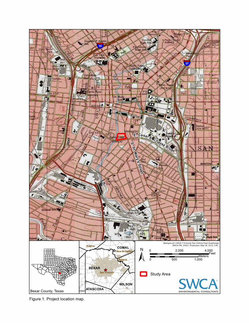
1
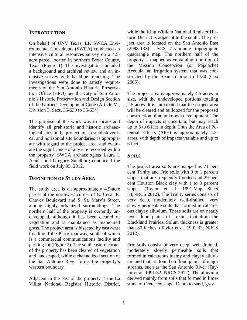
INTRODUCTION
On behalf of UNV Texas, LP, SWCA Envi-
ronmental Consultants (SWCA) conducted an
intensive cultural resources survey on a 4.5-
acre parcel located in northern Bexar County,
Texas (Figure 1). The investigations included
a background and archival review and an in-
tensive survey with backhoe trenching. The
investigations were done to satisfy require-
ments of the San Antonio Historic Preserva-
tion Office (HPO) per the City of San Anto-
nio’s Historic Preservation and Design Section
of the Unified Development Code (Article VI,
Division 3, Secs. 35-630 to 35-634).
The purpose of the work was to locate and
identify all prehistoric and historic archaeo-
logical sites in the project area, establish verti-
cal and horizontal site boundaries as appropri-
ate with regard to the project area, and evalu-
ate the significance of any site recorded within
the property. SWCA archaeologists Laura I.
Acuña and Gregory Sundborg conducted the
field work on July 05, 2012.
DEFINITION OF STUDY AREA
The study area is an approximately 4.5-acre
parcel at the northwest corner of E. Cesar E.
Chavez Boulevard and S. St. Mary’s Street,
among highly urbanized surroundings. The
northern half of the property is currently un-
developed, although it has been cleared of
vegetation and is maintained as manicured
grass. The project area is bisected by east-west
trending Tolle Place roadway, south of which
is a commercial communications facility and
parking lot (Figure 2). The southeastern corner
of the property has been cleared of vegetation
and landscaped, while a channelized section of
the San Antonio River forms the property’s
western boundary.
Adjacent to the east of the property is the La
Villita National Register Historic District,
while the King William National Register His-
toric District is adjacent to the south. The pro-
ject area is located on the San Antonio East
(2998-133) USGS 7.5-minute topographic
quadrangle map. The northern half of the
property is mapped as containing a portion of
the Mission Concepcion (or Pajalache)
Acequia, an irrigation system that was con-
structed by the Spanish prior to 1730 (Cox
2005).
The project area is approximately 4.5-acres in
size, with the undeveloped portions totaling
2.5-acres. It is anticipated that the project area
will be cleared and bulldozed for the proposed
construction of an unknown development. The
depth of impacts is uncertain, but may reach
up to 5 to 6 feet in depth. Thus the Area of Po-
tential Effects (APE) is approximately 4.5-
acres, with depth of impacts variable and up to
6 feet.
SOILS
The project area soils are mapped as 71 per-
cent Trinity and Frio soils with 0 to 1 percent
slopes that are frequently flooded and 29 per-
cent Houston Black clay with 1 to 3 percent
slopes (Taylor et al. 1991:Map Sheet
54;NRCS 2012). The Trinity series consists of
very deep, moderately well-drained, very
slowly permeable soils that formed in calcare-
ous clayey alluvium. These soils are on nearly
level flood plains of streams that drain the
Blackland Prairies. Solum thickness is greater
than 80 inches. (Taylor et al. 1991:32; NRCS
2012).
Frio soils consist of very deep, well-drained,
moderately slowly permeable soils that
formed in calcareous loamy and clayey alluvi-
um and that are found on flood plains of major
streams, such as the San Antonio River (Tay-
lor et al. 1991:32; NRCS 2012). The alluvium
derived mainly from soils that formed in lime-
stone of Cretaceous age. Depth to sand, grav-
New Braunfels
_̂San Antonio
Schertz
Boerne
BEXAR
COMAL
WILSONATASCOSABexar County, Texas
Figure 1. Project location map.
§̈¦37
Background: USGS 7.5-minute San Antonio East QuadrangleSWCA PN. 23527, Production: May 30, 2012, CAC.
R
±0 2,000 4,000Feet0 500 1,000
Meters
Study Area
§̈¦35
E. Cesar E. Chavez Blvd.
S. St. Mary's Street

Figure 2. Study area map.
R
Background: ArcGIS Online, Bing Maps Hybrid WMS.SWCA PN. 23527, Production: May 30, 2012, CAC.±
0 200Feet0 50
MetersStudy Area
E. Cesar E. Chavez Blvd.
Tolle Place
S. St. Mary's StreetSa
n Anto
nio Ri
ver
4
-el, or limestone ranges from 6 to about 30
feet (NRCS 2012).
The Houston series consists of moderately
well-drained, slowly permeable, cyclic soils
that formed in alkaline clays and chalk of the
Blackland Prairies. Houston soils are on near-
ly level to sloping uplands. These clayey soils
have very high shrink-swell potential. Depth
to bedrock ranges from 4 to 9 feet. The soil is
clay throughout, ranging from 60 to 80 per-
cent with 60 to 70 percent being most com-
mon. Common or many intersecting slicken-
sides are in the AC and C horizons. These are
cyclic soils, with cycles of microknolls and
microbasins repeated at linear intervals of 6 to
12 feet (Taylor et al. 1991:21; NRCS 2012).
GEOLOGY
The underlying geology of the project area is
Quaternary-age fluviatile terrace deposits ad-
jacent to the San Antonio River (Barnes
1983). These terrace deposits consist of pre-
dominately gravel, limestone, dolomite, and
chert, with sand, silt, and clay. Most low ter-
race deposits along entrenched streams are
above flood level (Barnes 1983).
METHODS
BACKGROUND REVIEW
SWCA conducted a thorough background
search of cultural resources and environmental
literature pertaining to the project area. An
SWCA archaeologist reviewed the Van Raub
USGS 7.5-minute topographic quadrangle
maps at the Texas Archeological Research La-
boratory (TARL) and searched the Texas His-
torical Commission’s (THC) Texas Archeolog-
ical Sites Atlas (Atlas) online database and the
Texas Department of Transportation (TxDOT)
Historic Overlay maps for any previously rec-
orded surveys and historic or prehistoric ar-
chaeological sites located in or near the pro-
ject area. In addition to identifying recorded
archaeological sites, the review included in-
formation on the following types of cultural
resources: National Register of Historic Places
(NRHP) properties, State Archeological
Landmark (SALs), Official Texas Historical
Markers (OTHM), Registered Texas Historic
Landmarks (RTHLs), cemeteries, and local
neighborhood surveys. The archaeologist also
examined the NRCS Soil Survey database for
Bexar County and the Geologic Atlas of Texas,
San Antonio Sheet (Barnes 1983). Aerial pho-
tographs were reviewed to assist in identifying
any disturbances. As part of the review, a
SWCA archaeologist consulted the Texas De-
partment of Transportation (TxDOT) Historic
Overy Maps, a mapping/GIS system with his-
toric maps, and resource information covering
most portions of the state (Foster et al. 2006).
FIELD METHODS
SWCA’s investigations consisted of an inten-
sive pedestrian survey with backhoe trenching
within the project area. Archaeologists exam-
ined the ground surface and exposures for cul-
tural resources. Subsurface investigations in-
volved backhoe trenching in settings with the
potential to contain buried cultural materials.
For project areas, the THC’s survey standards
require a minimum of two shovel tests every
acre, when the project area is 3–10 acres in
size. The current project area is 4.5-acres in
size, thus requiring a minimum of two shovel
tests within the property. However, given the
potential for deeply buried deposits, SWCA
conducted backhoe trench excavations. Trench
locations were based on the results of the his-
toric map review and determined in the field.
Backhoe trenches were 1.2 to 1.8 m (4 to 6
feet deep), 7 m (23 feet) in length, and 0.75 m
(2.5 feet) wide. During excavation, all trench-
ing was monitored by an experienced archae-
ologist. All work was performed in accordance
with OSHA (29 CFR Part 1926). The entire
process was photographed and documented on
5
a standardized form. Upon completion of ex-
cavation, all trenches are backfilled, leveled,
and returned, as much as possible, to original
state. As this was a non-collection survey, any
artifacts discovered were to be tabulated, ana-
lyzed, and documented in the field, but not
collected. Temporally diagnostic artifacts, if
present, were to be described in detail and
photographed in the field. Only especially rare
artifacts or discoveries were to be collected.
RESULTS
BACKGROUND REVIEW
HISTORIC CONTEXT
The following context is focused on the histo-
ry and evolution of the San Antonio area dur-
ing the Spanish era. The Historic period in
central Texas theoretically begins with the ar-
rival of Alvar Nuñez Cabeza de Vaca and the
survivors of the Narváez expedition along the
Texas coast in 1528 (Krieger 2002). European
incursions, however, into south-central Texas
were initially rare, and the first Europeans did
not settle in this region until around A.D. 1700.
Spanish incursions into the region from the
late seventeenth century on left valuable in-
formation on native groups and tribes. Several
scholars, including Hester (1989) and New-
comb (2002), have provided historical ac-
counts of Native Americans and their interac-
tions with the Spanish, the Republic of Mexi-
co, the Texas Republic, and the United States
throughout the region.
The San Antonio area was first explored in
1691 by the Governor of the Spanish Province
of Texas, Domingo Terán de los Ríos, and Fa-
ther Damián Massenet. The pair traveled to
San Pedro Springs, where they encountered a
hunter-gatherer tribe named Payaya. In their
village named Yanaguana, the Payaya lived in
simple huts made of brushwood and grass.
The river and village were renamed after San
Antonio de Padua by Terán and Massenet
(Johnston 1947).
Further Spanish exploration was conducted in
1709 by Father Antonio de San Buenaventura
y Olivares. Father Olivares was the first to ex-
press interest in setting up a mission in the San
Antonio area (Fehrenbach 2012; Johnston
1947).
SPANISH MISSIONS
After a series of missions had been established
in what would become eastern Texas, the
Spanish government in the New World decid-
ed to begin settlement in 1718 at a bend in the
San Antonio River. Mission San Antonio de
Valero was founded on May 1, 1718 and was
followed four days later by the nearby San
Antonio de Béxar Presidio and the civil set-
tlement, Villa de Béxar. The location was a
convenient stopping point on the Camino Re-
al, the newly established highway founded in
1691 by the previously mentioned Domingo
Terán de Los Ríos and Father Damián Masse-
net to connect Mexico to the East Texas mis-
sions. However, in 1719, war between France
and Spain resulted in the withdrawal of the
Spanish from the East Texas missions. The
Spanish reestablished their mission communi-
ties near the settlement along the San Antonio
River.
Mission San Antonio de Valero, originally lo-
cated west of San Pedro Springs, survived
three moves and numerous setbacks during its
early years (Schoelwer 2012). The mission
was moved to the west side of the San Antonio
River around 1730. After a disastrous epidem-
ic in 1739, the mission was moved to its pre-
sent location on higher ground and is now
known as the Alamo (Cruz 2012).
There is little available information on aborig-
inal groups and their ways of life except for
the fragmentary data Spanish missionaries
6
gathered. The general project area was report-
edly inhabited by several aboriginal groups,
which included Tonkawa, Lipan Apache, Co-
manche, Jumano, Catqueza, and Karankawa
(Cecil and Greene 2012; Foster 1995; New-
comb 2002). In the San Antonio area and areas
to the south, these groups have been referred
to collectively as Coahuiltecans because of an
assumed similarity in way of life, but many
individual groups may have existed (Campbell
1988). Particular Coahuiltecan groups, such as
the Payaya and Juanca, have been identified as
occupying the San Antonio area (Campbell
1988).
Some native groups made contact with the
Spanish in San Antonio seeking protection
from the Apache at newly established Spanish
missions, settlements, and presidios like the
Mission San Antonio de Valero and the Presid-
io San Antonio de Bexar (Chipman 1992:117).
The Spanish in turn, actively recruited the Na-
tive Americans to help bolster their settle-
ments on this northern frontier in response to a
perceived increase of French influence in Lou-
isiana and east Texas.
The Spanish presence around San Antonio is
best seen as part of the complex European po-
litical picture of the time. The beginning of the
late-seventeenth and early-eighteenth centu-
ries was an era of more-permanent contact be-
tween Europeans and Native Americans. Spe-
cifically, increasing numbers of Spanish
moved northward out of Mexico establishing
settlements and missions on their northern
frontier (see Castañeda [1936–1958] and Bol-
ton [1970] for extended discussions of the
mission system and Indian relations in Texas
and the San Antonio area).
The Spanish Missions also served as a point of
contact between the southward-advancing
Apaches and the Spanish, with native groups
often caught in between. Disease and hostile
encounters with Europeans and intruding
groups such as the Apache were already
wreaking their inevitable and disastrous havoc
on native social structures and economic sys-
tems by this time.
Establishment of the mission system in the
first half of the eighteenth century to its ulti-
mate demise around 1800 brought the peace-
ful movement of some indigenous groups into
mission life, but others were forced or moved
in to escape the increasing hostilities of
southward-moving Apaches and Comanches.
Many of the Payaya and Juanca lived at Mis-
sion San Antonio de Valero, but so many died
there that their numbers declined rapidly
(Campbell 1988:106, 121–123). By the end of
the mission period, European expansion, dis-
ease, and intrusions by other Native American
peoples had decimated many Native American
groups. The small numbers of surviving
Payaya and Juanca were acculturated into
mission life. The last references to the Juanca
and Payaya were recorded in 1754 and 1789,
respectively, in the waning days of the mission
(Campbell 1988:98, 123). By that time, intru-
sive groups such as the Tonkawa, Apache, and
Comanche had moved into the region to fill
the void. Outside of the missions, few sites
attributable to these groups have been investi-
gated. To complicate matters, many aboriginal
ways of life endured even after contact with
the Spanish. For example, manufacture of
stone tools continued even for many groups
settling in the missions (Fox 1979).
San Antonio became the capital of Spanish
Texas in 1773. By 1778, the settlement had a
population of 2,060 including those Indians
living in the missions. However, conditions
within the settlement were often described as
poor, resulting from its location at the edge of
Spanish-controlled Texas. The population was
comprised of a mix of Europeans, mestizos,
and a few slaves. By 1795, all the missions in
San Antonio were secularized and Mission
San Antonio de Valero, later called the Alamo,
7
was converted to a military barracks
(Fehrenbach 1978).
SPANISH ACEQUIAS
As the Spanish established missions in Bexar
County, they also devised an irrigation and
water supply system using spring water. Friars
supervised the labor of Indians, settlers, and
soldiers to construct acequias, or canals, and
dams (Cox 2005). The system distributed wa-
ter for agriculture, personal consumption, and
other household uses (Porter 2009:48). Thus,
the system represents the first municipal water
system in what would become the United
States.
The first canal dug at the San Antonio Springs
between 1718 and 1744 was the Acequia Ma-
dre (also known as Alamo Madre and Alamo
Ditch). It diverted water from the east side of
the headwaters of the San Antonio River, just
below San Antonio Springs, in present-day
Brackenridge Park. The Acequia Madre con-
tinued to supply water until the early 1900s,
and is a contributing element of the San Anto-
nio Missions National Historic Park (NRHP
No. 78003147).
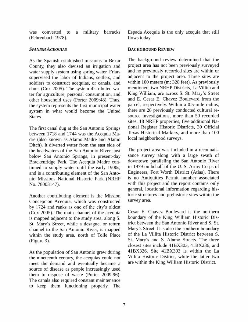
Another contributing element is the Mission
Concepcion Acequia, which was constructed
by 1724 and ranks as one of the city’s oldest
(Cox 2005). The main channel of the acequia
is mapped adjacent to the study area, along S.
St. Mary’s Street, while a desague, or return
channel to the San Antonio River, is mapped
within the study area, north of Tolle Place
(Figure 3).
As the population of San Antonio grew during
the nineteenth century, the acequias could not
meet the demand and eventually became a
source of disease as people increasingly used
them to dispose of waste (Porter 2009:96).
The canals also required constant maintenance
to keep them functioning properly. The
Espada Acequia is the only acequia that still
flows today.
BACKGROUND REVIEW
The background review determined that the
project area has not been previously surveyed
and no previously recorded sites are within or
adjacent to the project area. Three sites are
within 100 meters (m; 328 feet). As previously
mentioned, two NRHP Districts, La Villita and
King William, are across S. St. Mary’s Street
and E. Cesar E. Chavez Boulevard from the
parcel, respectively. Within a 0.5-mile radius,
there are 28 previously conducted cultural re-
source investigations, more than 50 recorded
sites, 18 NRHP properties, five additional Na-
tional Register Historic Districts, 30 Official
Texas Historical Markers, and more than 100
local neighborhood surveys.
The project area was included in a reconnais-
sance survey along with a large swath of
downtown paralleling the San Antonio River
in 1979 on behalf of the U. S. Army Corps of
Engineers, Fort Worth District (Atlas). There
is no Antiquities Permit number associated
with this project and the report contains only
general, locational information regarding his-
toric structures and prehistoric sites within the
survey area.
Cesar E. Chavez Boulevard is the northern
boundary of the King William Historic Dis-
trict between the San Antonio River and S. St.
Mary’s Street. It is also the southern boundary
of the La Villita Historic District between S.
St. Mary’s and S. Alamo Streets. The three
closest sites include 41BX303, 41BX236, and
41BX326. Site 41BX303 is within the La
Villita Historic District, while the latter two
are within the King William Historic District.
Figure 3. Property on COSA Historic Preservation Office Acequia Map Sheet 16-57.
R
Background: Acequia Map Sheet 16-57.SWCA PN. 23527, Production: June 21, 2012, CAC.±
0 400Feet0 100
MetersStudy Area
Desa
gue
Mission Concepcion
(Pajalache) Acequia
San A
ntonio
River
9
King William National Register Historic Dis-
trict
The King William Historic District is a neigh-
borhood of Victorian and turn-of-the-century
homes lining both sides of King Williams
Street. The five-block street contains 43 prop-
erties that contribute to the district’s nine-
teenth-century component, which also in-
cludes three mansions: Polk Mansion, Groos
House, and Steves Homestead. In all, the dis-
trict is comprised of 74 contributing struc-
tures. The area was primarily established by
prosperous German businessmen in the second
half of the nineteenth century (National Regis-
ter Nomination Form No. 72001349).
La Villita National Register Historic District
The La Villita Historic District is four blocks
south of the Alamo and is comprised of 27
properties that contribute to the district’s sim-
ple vernacular masonry style. La Villita was
the site of an early Indian village, a neighbor-
hood for the families of the presidio soldiers,
and, in 1773, home to refugees from the failed
east Texas missions. In the 1840s German
immigrants began moving into La Villita.
They and later Swiss and French immigrants
modified the community and gave it a distinct
European flavor (National Register Nomina-
tion Form No. 72001350).
SITE 41BX303
Site 41BX303 encompasses the entire block
bounded by Arciniega Street, S. Alamo Street,
Cesar E. Chavez Boulevard, and S. Presa
Street, and is immediately west of the south-
ern portion of Hemisfair Plaza. It was record-
ed in 1978 by the Center for Archaeological
Research at the University of Texas at San An-
tonio (CAR-UTSA) prior to the construction
of the Plaza Nacional Hotel at this location
(Katz et al. 1978).
Three of the 12 residential and commercial
structures documented on the block were left
intact and renovated for use by the hotel: 422
Presa, 204-6 Arciniega and 220 Arciniega. Of
the remaining nine locations, five were deter-
mined and investigated to varying degrees
(426, 416-18 and 412 S. Presa, 224 and 228
Arciniega and 501-505 S. Alamo). Seven cul-
tural features, unattached to any of the resi-
dential structures, were identified and investi-
gated, including three irrigation ditches, one
cistern with a possible cooling chamber, one
domestic trash pit, one latrine, and one pit of
undetermined function (Katz et al. 1978).
Historical documentation suggests site
41BX303 was utilized completely for agricul-
tural purposes until at least 1811–1813 and
perhaps as late as 1840–1841. The decade of
the 1880’s saw the construction of most of the
houses at the site; the earliest two were built
between 1841 and 1851, the latest in 1912
(Katz et al. 1978).
SITE 41BX236
Site 41BX236 is a residential structure at 101
King William Street and was recorded by John
Clark in 1974 on behalf of the San Antonio
Conservation Society, the owners of the prop-
erty. At that time, most of the grounds had
been converted into parking lots (Atlas 2012).
SITE 41BX326
Site 41BX326 is the Mayer House at the
southwest corner of the intersection of Cesar
E. Chavez Boulevard and S. St. Mary’s Street.
The site was recorded in 1978 by CAR-UTSA
on behalf of the San Antonio Conservation
Society, the owners of the property. Although
the residential structure had long been razed,
investigations focused on relocating the struc-
ture and, subsequently, excavating the cellar
deposits (Ivey 1978).
10
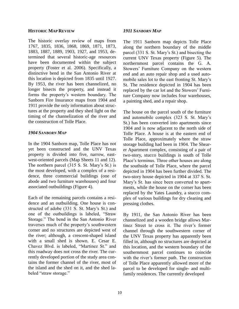
HISTORIC MAP REVIEW
The historic overlay review of maps from
1767, 1835, 1836, 1868, 1869, 1871, 1873,
1883, 1887, 1889, 1903, 1927, and 1953, de-
termined that several historic-age resources
have been documented within the subject
property (Foster et al. 2006). Specifically, a
distinctive bend in the San Antonio River at
this location is depicted from 1835 until 1927.
By 1953, the river has been channelized, no
longer bisects the property, and instead it
forms the property’s western boundary. The
Sanborn Fire Insurance maps from 1904 and
1911 provide the only information about struc-
tures at the property and they shed light on the
timing of the channelization of the river and
the construction of Tolle Place.
1904 SANBORN MAP
In the 1904 Sanborn map, Tolle Place has not
yet been constructed and the UNV Texas
property is divided into five, narrow, east-
west-oriented parcels (Map Sheets 11 and 12).
The northern parcel (315 S. St. Mary’s St.) is
the most developed, with a complex of a resi-
dence, three commercial buildings (one of
abode and two furniture warehouses) and four
associated outbuildings (Figure 4).
Each of the remaining parcels contains a resi-
dence and an outbuilding. One house is con-
structed of adobe (331 S. St. Mary’s St.) and
one of the outbuildings is labeled, “Straw
Storage.” The bend in the San Antonio River
traverses much of the property’s southwestern
corner and no structures are depicted west of
the river; although, a crescent-shaped island
with a small shed is shown. E. Cesar E.
Chavez Blvd. is labeled, “Martinez St.” and
this roadway does not cross the river. The cur-
rently developed portion of the study area con-
tains the former channel of the river, most of
the island and the shed on it, and the shed la-
beled “straw storage.”
1911 SANBORN MAP
The 1911 Sanborn map depicts Tolle Place
along the northern boundary of the middle
parcel (331 S. St. Mary’s St.) and bisecting the
current UNV Texas property (Figure 5). The
northernmost parcel contains the G. A.
Stowers’ Furniture Company on the western
end and an auto repair shop and a used auto-
mobile sales lot to the east fronting St. Mary’s
St. The residence depicted in 1904 has been
replaced by the car lot and the Stowers’ Furni-
ture Company now includes four warehouses,
a painting shed, and a repair shop.
The house on the parcel south of the furniture
and automobile complex (323 S. St. Mary’s
St.) has been converted into apartments since
1904 and is now adjacent to the north side of
Tolle Place. A house is at the eastern end of
Tolle Place, approximately where the straw
storage building had been in 1904. The Shear-
er Apartment complex, consisting of a pair of
two-story, stucco buildings is south of Tolle
Place’s terminus. Three other houses are along
the southside of Tolle Place, where the parcel
depicted in 1904 has been further divided. The
two-story house depicted in 1904 at 337 S. St.
Mary’s St. has since been converted to apart-
ments, while the house on the corner has been
replaced by the Yates Laundry, a stucco com-
plex of various buildings for dry cleaning and
pressing clothes.
By 1911, the San Antonio River has been
channelized and a wooden bridge allows Mar-
tinez Street to cross it. The river’s former
channel through the southwestern corner of
the UNV Texas property has apparently been
filled in, although no structures are depicted at
this location, and the western boundary of the
southernmost parcel continues to coincide
with the river’s former path. The construction
of Tolle Place apparently allowed more of the
parcel to be developed for single- and multi-
family residences. The currently developed
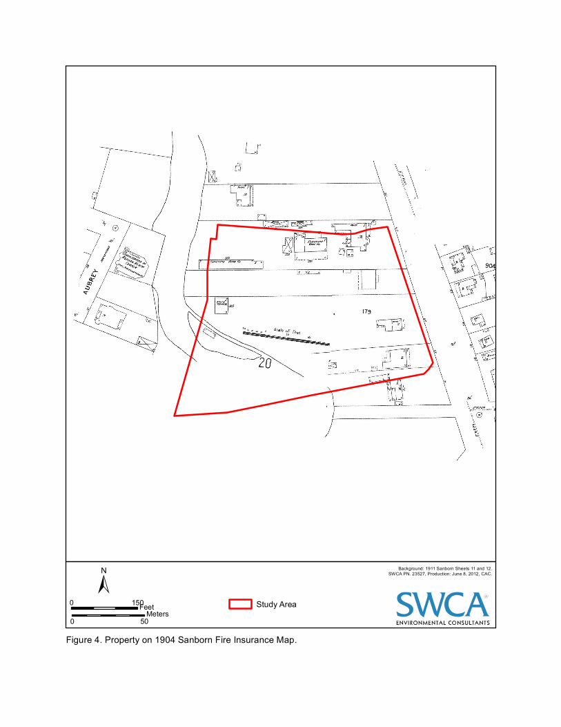
Figure 4. Property on 1904 Sanborn Fire Insurance Map.
R
Background: 1911 Sanborn Sheets 11 and 12.SWCA PN. 23527, Production: June 8, 2012, CAC.±
0 150Feet0 50
MetersStudy Area
Figure 5. Property on 1911 Sanborn Fire Insurance Map.
R
Background: 1911 Sanborn Sheets 53a, 55a, and 56a.SWCA PN. 23527, Production: June 4, 2012, CAC.±
0 150Feet0 50
MetersStudy Area
13
portion of the study area contains the house
and shed at the eastern end of Tolle Place, the
Shearer Apartment complex, and an adjacent
house with a shed behind it.
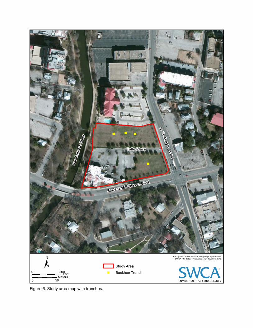
FIELD SURVEY
On July 5, 2012, two SWCA archaeologists
conducted an intensive pedestrian survey with
backhoe trenching on the 4.5-acre UNV Texas
Property. The entire property was examined
and a total of four backhoe trenches excavated
in the cleared, undisturbed areas (Table 1;
Figure 6). Based on the historic map review,
these areas had the potential to contain depos-
its related to historic residential and commer-
cial occupations and evidence of the acequia.
The intensive surface inspection determined
these areas, north of Tolle Place and the prop-
erty’s southeastern corner, are 2 to 3 feet high-
er in elevation than street level, indicating in-
tentional infilling. Other disturbances include
a sprinkler system along the perimeter of the
property with the western portion abutting the
San Antonio River hike and bike trail.
Three backhoe trenches were excavated north
of Tolle Place in an attempt to find evidence
of the eighteenth-century desague, or back
channel, of the Mission Concepcion Acequia
(Figure 7). Backhoe trench 1 (BHT 1) was ex-
cavated within the center of the northern sec-
tion over the possible location of the acequia.
Excavations revealed upper strata of gravels
and construction fill down to 70 cmbs. The
construction fill consisted of mixed gravels
and pebbles with caliche fragments. The lower
stratum, 70–160, consisted of brown (10YR
4/3) silty clay loam (Figure 8). The upper
stratum contained concrete slabs, asphalt, and
two small brick fragments. No distinctive fea-
tures or diagnostic materials were encoun-
tered. The silty loam represents the alluvial
deposits of the former channel of the San An-
tonio River. Based on the 1904 Sanborn map,
the former channel is just south of the location
of BHT 1.
BHT 2, excavated west of BHT 1, was similar
in profile and contained rebar, and a decom-
missioned gas line between 30–110 cmbs. An
old cast iron line 6 inches in diameter was en-
countered at 110 cmbs (Figure 9). Cast iron
pipe was first manufactured in the eastern
United States at the turn of the nineteenth cen-
tury and increased in the 1890s (CISPI 2006).
Cities used cast iron pipe for waterworks,
sewage systems, and even gas lines. It was
also used for residential construction and in
commercial and industrial structures as drain-
age pipes to convey discharge from the build-
ing to the city sewer or other means of dispos-
al (CISPI 2006). The exact date of pipe could
not be determined but may date to the late
nineteenth- to early twentieth century.
BHT 3, excavated east of BHT 1, contained
several intermittent layers of gravel and fill
with large cobbles and concrete fragments
down to 90 cmbs (Figure 10). Small brick
fragments and canvas cloth wrapped in plastic
was encountered between 60–80 cmbs. A
piece of bovine fauna was encountered just
below the gravel material at 100 cmbs within
the second stratum. The lower stratum con-
sisted of very dark, grayish-brown (10YR 3/2)
silty clay loam down to 187 cmbs. No distinc-
tive features or diagnostic materials were en-
countered within the excavations.
BHT 4 was excavated in the southeastern cor-
ner of the property. As with the other trenches,
the upper stratum consisted of gravels, cob-
bles, and fill down to 100 cmbs (Figure 11). A
2-inch diameter water pipe and asphalt were
encountered at 20-30 cmbs and a piece of
whiteware and a brick fragment was encoun-
tered at 30–50 cmbs. The water pipe appears
to be associated with an old sprinkler system
that is no longer in use. The lower stratum
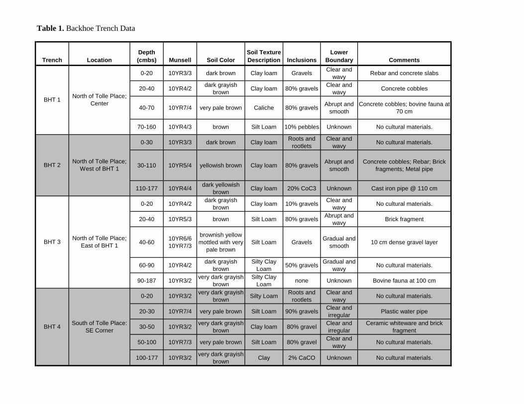
Trench LocationDepth (cmbs) Munsell Soil Color
Soil Texture Description Inclusions
Lower Boundary Comments
0-20 10YR3/3 dark brown Clay loam GravelsClear and
wavyRebar and concrete slabs
20-40 10YR4/2dark grayish
brownClay loam 80% gravels
Clear and
wavyConcrete cobbles
40-70 10YR7/4 very pale brown Caliche 80% gravelsAbrupt and
smooth
Concrete cobbles; bovine fauna at
70 cm
70-160 10YR4/3 brown Silt Loam 10% pebbles Unknown No cultural materials.
0-30 10YR3/3 dark brown Clay loamRoots and
rootlets
Clear and
wavyNo cultural materials.
30-110 10YR5/4 yellowish brown Clay loam 80% gravelsAbrupt and
smooth
Concrete cobbles; Rebar; Brick
fragments; Metal pipe
110-177 10YR4/4dark yellowish
brownClay loam 20% CoC3 Unknown Cast iron pipe @ 110 cm
0-20 10YR4/2dark grayish
brownClay loam 10% gravels
Clear and
wavyNo cultural materials.
20-40 10YR5/3 brown Silt Loam 80% gravelsAbrupt and
wavyBrick fragment
40-6010YR6/6
10YR7/3
brownish yellow
mottled with very
pale brown
Silt Loam GravelsGradual and
smooth10 cm dense gravel layer
60-90 10YR4/2dark grayish
brown
Silty Clay
Loam50% gravels
Gradual and
wavyNo cultural materials.
90-187 10YR3/2very dark grayish
brown
Silty Clay
Loamnone Unknown Bovine fauna at 100 cm
0-20 10YR3/2very dark grayish
brownSilty Loam
Roots and
rootlets
Clear and
wavyNo cultural materials.
20-30 10YR7/4 very pale brown Silt Loam 90% gravelsClear and
irregularPlastic water pipe
30-50 10YR3/2very dark grayish
brownClay loam 80% gravel
Clear and
irregular
Ceramic whiteware and brick
fragment
50-100 10YR7/3 very pale brown Silt Loam 80% gravelClear and
wavyNo cultural materials.
100-177 10YR3/2very dark grayish
brownClay 2% CaCO Unknown No cultural materials.
BHT 4South of Tolle Place:
SE Corner
Table 1. Backhoe Trench Data
BHT 1North of Tolle Place;
Center
BHT 2North of Tolle Place;
West of BHT 1
BHT 3North of Tolle Place;
East of BHT 1
"" "
"
Figure 6. Study area map with trenches.
R
Background: ArcGIS Online, Bing Maps Hybrid WMS.SWCA PN. 23527, Production: July 19, 2012, CAC.±
0 200Feet0 50
Meters
Study Area" Backhoe Trench
E. Cesar E. Chavez Blvd.
Tolle Place
S. St. Mary's StreetSa
n Anto
nio Ri
ver

"" "
"
Figure 7. Property on COSA Historic Preservation Office Acequia Map Sheet 16-57 with trenches.
R
Background: Acequia Map Sheet 16-57.SWCA PN. 23527, Production: July 19, 2012, CAC.±
0 400Feet0 100
Meters
Study Area" Backhoe Trench
Desa
gue
Mission Concepcion
(Pajalache) Acequia
San A
ntonio
River
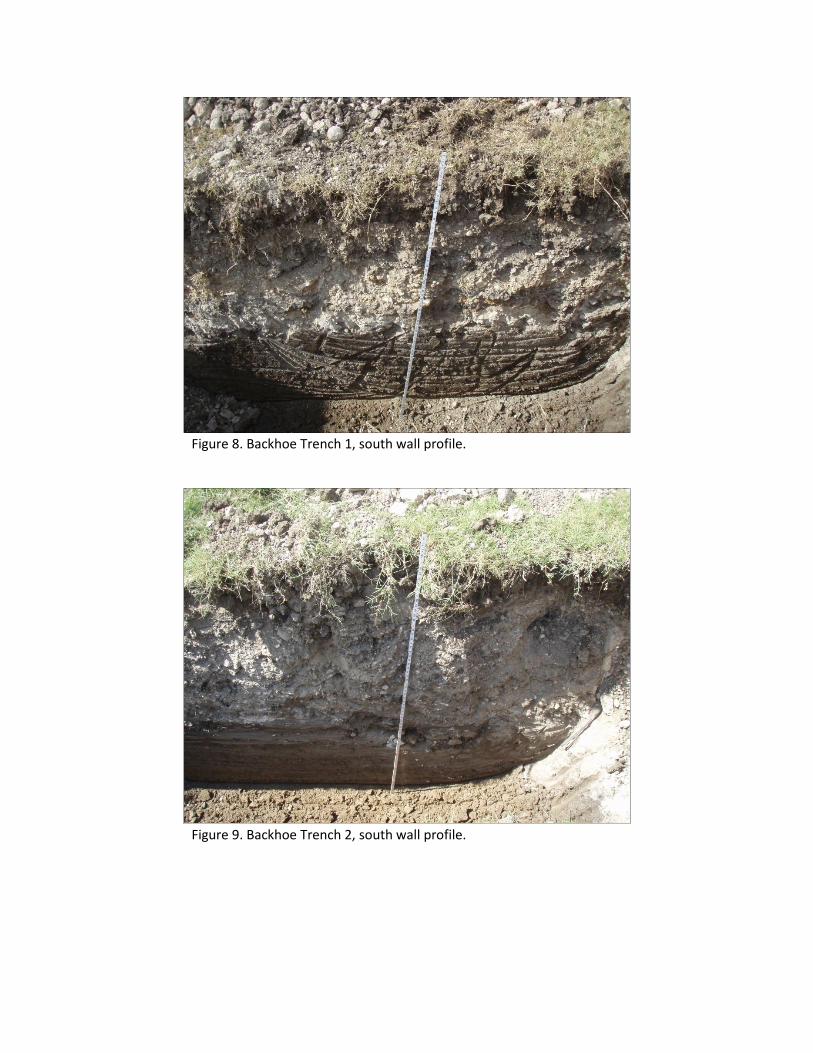
Figure 8. Backhoe Trench 1, south wall profile.
Figure 9. Backhoe Trench 2, south wall profile.
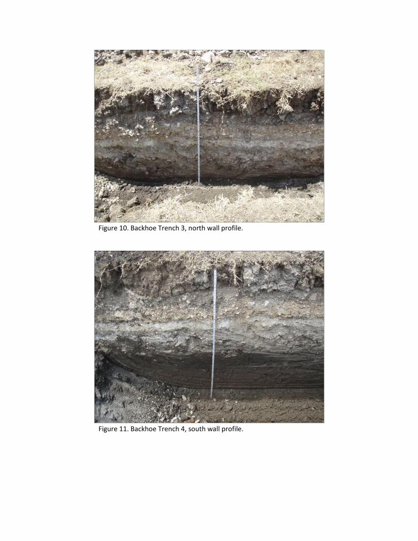
Figure 10. Backhoe Trench 3, north wall profile.
Figure 11. Backhoe Trench 4, south wall profile.
19
consisted of very dark, grayish-brown (10YR
3/2) silty clay loam down to 177 cmbs.
The survey revealed the project area to be in-
tensively disturbed by almost 100 years of
previous residential and commercial construc-
tion and land clearing activities. The area has
been elevated with fill and only bits and piec-
es of the historic occupations are left. Evi-
dence of the acequia was not encountered in
the northern backhoe trenches and materials
were limited to fragments of old pipelines and
historic debris. Any evidence of the acequia
was likely destroyed by subsequent historic
occupations. No distinct features or diagnostic
materials were encountered.
SUMMARY AND RECOMMENDATIONS
On behalf of UNV Texas LP, Inc., SWCA
conducted an intensive cultural resource sur-
vey of a 4.5-acre property in Bexar County,
Texas. The investigations were done to satisfy
requirements of the San Antonio Historic
Preservation Office (HPO) per the City of San
Antonio’s Historic Preservation and Design
Section of the Unified Development Code
(Article VI, Division 3, Secs 35-630 to 35-
634). These investigations included a thor-
ough background review and an intensive pe-
destrian survey with subsurface investigations.
The background review determined that the
project area has not been previously surveyed
and that no previously recorded sites are with-
in the project area. However, three sites are
within 100 m of the project area and two
NRHP Districts are located across S. St.
Mary’s Street and E. Cesar E. Chavez Boule-
vard. The historic maps review, including
Sanborn maps, determined that several histor-
ic-age resources have been documented in
property. In addition, the main channel of the
Mission Concepcion Acequia is mapped adja-
cent to the project area, while a desague is
mapped within the property.
The THC standards require 2 shovel tests
within the 4.5-acre project area. However, in-
vestigations utilized backhoe trench excava-
tions due to the results of the historic map re-
view and locale near the San Antonio River.
The four backhoe trenches were targeted in
areas with the highest potential for containing
buried cultural deposits, specifically the
desague of the Mission Concepcion
Four backhoe trenches were excavated within
the cleared areas of the project area, north of
Tolle Place and the southeastern corner of the
property. Excavations revealed a thick layer of
gravels and infill ranging from 70–100 cmbs
in depth followed by silty clay loam up to
178–188 cmbs. The upper stratum contained
evidence of historic occupations related to res-
idential and commercial development consist-
ing of concrete cobbles, rebar, a former gas
line, and a cast iron pipe. Evidence of the
desague was not encountered during the inves-
tigations, nor were cultural features or diag-
nostic materials observed during the excava-
tions. The materials were in a completely dis-
turbed context and contain little to no integrity
or cultural significance. Overall, the survey
revealed the project area to be intensively dis-
turbed by previous land clearing activities and
commercial development.
The proposed undertaking will have no effects
on any significant cultural resources and
SWCA recommends no further archaeological
investigations within the APE. No artifacts
were collected; thus, nothing was curated.
Should construction associated with the pro-
posed project extend beyond the currently de-
fined APE, then additional efforts would be
warranted to assess the nature of such impacts
on any undocumented cultural resources.
20
REFERENCES
Atlas (Texas Archaeological Sites Atlas)
2012 Texas Archaeological Site Atlas re-
stricted database, Texas Historical
Commission. http://pedernales.thc.
state.tx.us/. Accessed June 1, 2012.
Barnes, V. E.
1983 Geologic Atlas of Texas, San Antonio
Sheet. Bureau of Economic Geology,
The University of Texas at Austin.
Bolton, H. E.
1970 Texas in the Middle Eighteenth Cen-
tury: Studies in Spanish Colonial
History and Administration. The
Texas State Historical Association
and the University of Texas Press,
Austin.
Campbell, T. N.
1988 Indians of Southern Texas and
Northeastern Mexico: Selected Writ-
ings of Thomas Nolan Campbell.
Texas Archeological Research La-
boratory, with the cooperation of the
Department of Anthropology, the
College of Liberal Arts, and the Insti-
tute of Latin American Studies, The
University of Texas at Austin.
Castañeda, C. E.
1936–1958 Our Catholic Heritage in Texas,
1519–1936. 7 vols. Von Boeckmann-
Jones Co., Austin.
CISPI (Cast Iron Soil Pipe Institute)
2006 Cast Iron Soil Pipe and Fittings
Handbook. Chattanooga, Tennessee
Cecil, P. F., and D. P. Greene
2012 “Hays County”, The Handbook of
Texas Online. (http://www.
tshaonline.org/handbook/online/articl
es/hch11), accessed June 21, 2012.
Published by the Texas State Histori-
cal Association.
Chipman, D. E.
1992 Spanish Texas, 1519–1821. Universi-
ty of Texas Press, Austin, Texas.
Cox, I. W.
2005 Spanish Acequias of San Antonio.
Maverick Publishing Company, San
Antonio.
Cruz, G. R.
2012 “San José y San Miguel de Aguayo
Mission,” Handbook of Texas Online,
(http://www.tshaonline.org/handbook
/online/articles/uqs23), accessed June
21, 2012. Published by the Texas
State Historical Association.
Fehrenbach, T. R.
1978 Lone Star: A History of Texas and the
Texans. Macmillan. New York.
2012 “San Antonio, TX,” Handbook of
Texas Online, (http://www.
tshaonline.org/handbook/online/articl
es/hds02), accessed June 21, 2012.
Published by the Texas State Histori-
cal Association.
Foster, W. C.
1995 Spanish Expeditions into Texas,
1689–1768. University of Texas
Press, Austin.
Foster, T. R., T. Summerville, and T. Brown
2006 The Texas Historic Overlay: A Geo-
graphic Information System of His-
toric Map Images for Planning
Transportation Projects in Texas.
Prepared for the Texas Department of
Transportation by PBS&J, Austin.
Fox, D. E.
1979 The Lithic Artifacts of Indians at the
Spanish Colonial Missions, San An-
tonio, Texas. Special Report No. 8.
Center for Archaeological Research,
The University of Texas at San Anto-
nio.

21
Ivey, J. E.
1978 Archaeologuical investigations at the
Mayer House (41BX326) San Anto-
nio, Texas. Archaeological Survey
Report, No. 59. Center for Archaeo-
logical Research, The University of
Texas at San Antonio.
Katz, P. R, A. A. Fox, and C. McDowell
1978 Archaeological and Historical Inves-
tigations in the Arciniega Street Area,
Downtown San Antonio, Texas. Ar-
chaeological Survey Report, No. 61.
Center for Archaeological Research,
The University of Texas at San Anto-
nio.
Natural Resources Conservation Service
(NRCS)
2012 Soil Survey Staff, Natural Resources
Conservation Service, United States
Department of Agriculture. Web Soil
Survey of Bexar County.
http://websoilsurvey.nrcs.usda.gov/
accessed June 1, 2012.
Taylor, F. B., R. B. Hailey, and D. L. Rich-
mond
1991 Soil Survey of Bexar County, Texas.
United States Department of Agricul-
ture, Washington, D.C.