Embed Size (px)
Citation preview
23
Current and Historical Forest Conditions andDisturbance Regimes in the Hoosier-ShawneeEcological Assessment Area
George R. Parker and Charles M. Ruffner
ABSTRACT
We review the historical and current status of forests in the Hoosier-Shawnee
Ecological Assessment Area. Native American people influenced the vegetation
through fire and agricultural clearing across the region until the early 1800s when
European settlers arrived.
Clearing of the land for agriculture peaked in the early 1900s after which badly
eroded land was abandoned and either planted or naturally regenerated to forest.
Many of these abandoned farms were purchased for public parks and forests and
managed as timberlands throughout the 20th century.
Today, about 43 percent of the landscape is covered by forest and 49 percent in agri-
culture. Land use varies across the region depending on its suitability for nonforest
use. For instance, much of the uplands across the assessment area, including the
Ozark Highlands, Interior Low Plateau, Shawnee Hills (hereafter “Shawnee Hills”),
and Interior Low Plateau, Highland Rim (hereafter “Highland Rim”) Sections are
dominated by forest land. In contrast, much of the best lands are privately held and
support agricultural activities.
Forests are mostly temperate deciduous hardwoods with coniferous forests covering
only 8 percent of the forest area. Forests are currently dominated by oak and hickory
species that cover about 40 percent of the forest area. However, species composition is
changing from species established as the result of frequent past disturbances (<1950)
to more shade tolerant species as the result of the decreased disturbance regimes of the
late 20th century (>1950). There is concern about the loss of landscape diversity and
maintenance of oak species as these shifts occur, and current management activities are
being implemented to reduce this transition.
About the Authors:
George R. Parker
Professor of Forest Ecology,
Department of Forestry and
Natural Resources, Purdue
University, 1159 Forestry
Building, West Lafayette, IN
47907. Phone: 765-494-3602;
e-mail: [email protected]
Charles M. Ruffner
Assistant Professor of Forestry,
Department of Forestry,
Southern Illinois University,
Carbondale, IL 62901.
Phone: 618-453-7469;
e-mail: [email protected]
We review the historical and current status and
management of forest within the region sur-
rounding the Hoosier National Forest in south-
ern Indiana and the Shawnee National Forest
in southern Illinois. The assessment area,
encompassing over 12 million acres, has a long
history of human activity beginning with
Native American peoples 12,000 years before
present. Human-caused disturbances including
the use of fire, grazing by livestock, and exten-
sive clearing have been important factors in
determining the condition of the vegetation in
the region today.
We document the rich historical ecology of the
Hoosier-Shawnee Ecological Assessment Area
by coupling the historical disturbance regimes
with the changing vegetation patterns across
ecological units. Vegetation is examined within
the context of the National Hierarchical
Framework of Ecological Units, a classification
system that divides landscapes into ecologically
significant regions at multiple scales (Keys et
al. 1995). Section and subsection names and
numbers follow Keys et al. (1995) and are also
listed in Ponder (2004). The diversity of history
and management is discussed for 4 ecological
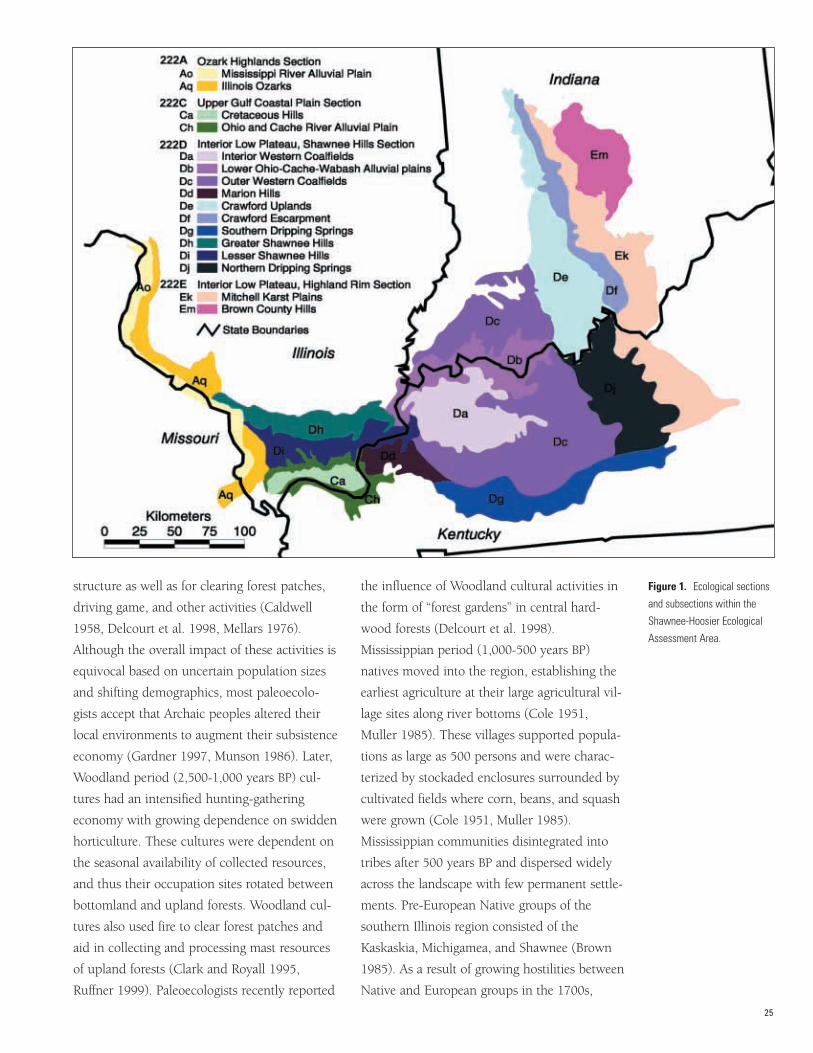
sections and 16 subsections (fig. 1). As history
of resource use, major forest types, and current
management activities are examined for each
unit, descriptions are limited due to the large
spatial area each unit encompasses.
MAJOR CHANGES IN VEGETA-TION AND THE INFLUENCE OFHUMANS FOLLOWING GLACIALRETREAT
Prehistoric period (before 1650)During the height of the Wisconsin glaciation
(28,000 years BP), ice sheets were located in
central Illinois and Indiana, but landscapes
were ice free in southern Indiana, southern
Illinois, and western Kentucky. The preglacial
landscape of this region, however, was greatly
influenced by the ice sheets to the north.
During the Wisconsin glaciation, a mixture of
boreal-northern hardwood/pine forests domi-
nated portions of western Kentucky and south-
ern Illinois alternating with southern pine-
prairie species during warm episodes (Franklin
1994, Whitehead 1997). Following the disap-
pearance of the ice sheets by 17,000 years BP,
deciduous species migrated into the region and
forests were comprised of oak, hickory, elm,
and beech species by 11,500 years BP. In the
Middle Holocene, a warming trend known as
the Hypsithermal period (8,700-5,000 years BP)
resulted in prairie expansion into the region;
mesophytic tree species retreated to mesic bot-
tomland and cove sites while oak and hickory
dominated upland sites (Franklin 1994).
Following the Hypsithermal, a cooler, moister
climate fostered woody invasion into prairie
and open savannas. Through time, these open
woodlands were heavily influenced and proba-
bly maintained by recurring fire, both natural
and human caused (Fralish et al. 1999). By
2,000 years BP, forests of the region were com-
prised of oak-hickory and mixed mesophytic
forests with inclusions of glades, prairies, and
savannas. Braun (1950) classified regional
forests as oak-hickory in the Ozark Hills of
southwestern Illinois and mixed mesophytic
across the Shawnee Hills of southeastern
Illinois and western Kentucky. Küchler (1964)
mapped the potential vegetation of this region
as oak-hickory.
Coupled with the natural interactions of vegeta-
tion and climate were the interactions of
humans and vegetation. By the Middle
Holocene, Archaic peoples had settled into the
lower Ohio and middle Mississippi River areas.
Archaic people (8,000-2,500 years BP) were
seminomadic hunter-gatherers who were adept
at manipulating their environments (Caldwell
1958; Delcourt 1987; Munson 1986, 1988).
Cultural ecologists believe Archaic peoples used
fire widely for altering forest composition and
24
structure as well as for clearing forest patches,
driving game, and other activities (Caldwell
1958, Delcourt et al. 1998, Mellars 1976).
Although the overall impact of these activities is
equivocal based on uncertain population sizes
and shifting demographics, most paleoecolo-
gists accept that Archaic peoples altered their
local environments to augment their subsistence
economy (Gardner 1997, Munson 1986). Later,
Woodland period (2,500-1,000 years BP) cul-
tures had an intensified hunting-gathering
economy with growing dependence on swidden
horticulture. These cultures were dependent on
the seasonal availability of collected resources,
and thus their occupation sites rotated between
bottomland and upland forests. Woodland cul-
tures also used fire to clear forest patches and
aid in collecting and processing mast resources
of upland forests (Clark and Royall 1995,
Ruffner 1999). Paleoecologists recently reported
the influence of Woodland cultural activities in
the form of “forest gardens” in central hard-
wood forests (Delcourt et al. 1998).
Mississippian period (1,000-500 years BP)
natives moved into the region, establishing the
earliest agriculture at their large agricultural vil-
lage sites along river bottoms (Cole 1951,
Muller 1985). These villages supported popula-
tions as large as 500 persons and were charac-
terized by stockaded enclosures surrounded by
cultivated fields where corn, beans, and squash
were grown (Cole 1951, Muller 1985).
Mississippian communities disintegrated into
tribes after 500 years BP and dispersed widely
across the landscape with few permanent settle-
ments. Pre-European Native groups of the
southern Illinois region consisted of the
Kaskaskia, Michigamea, and Shawnee (Brown
1985). As a result of growing hostilities between
Native and European groups in the 1700s,
25
Figure 1. Ecological sections
and subsections within the
Shawnee-Hoosier Ecological
Assessment Area.
numerous migrations moved tribal groups up
and down major river drainages. By the mid-
1700s, the lower Ohio River Valley was a major
thoroughfare for westward movement of dis-
placed tribes from the Mid-Atlantic including
the Delaware and Shawnee (McConnell 1992).
Population numbers varied during this period,
and the effect of humans on the environment is
poorly understood.
Historical accounts of the region depict the area
as heavily influenced by Native activities (Allen
1945, Brown 1985, Kimmerer and Lake 2001,
Temple 1966). Indeed, the anthropogenic land-
scape encountered by early European settlers in
the 18th century reflected a long-term interac-
tion between Native activities and vegetation
associations. Native American use of fire and
clearing land for agriculture was probably much
greater in the 1400s than it was in the 1700s
when Europeans started settling in the region
(Denevan 1992, Williams 2000). European dis-
eases had greatly reduced Native American
populations by the late 1,500s—early 1,600s,
reducing their overall impact on vegetation
across the landscape, allowing some recovery of
forested conditions by the 1700s when
Europeans became more active in the region
(Olson 1996). However, fire and agriculture
continued to be used across the landscape by a
smaller number of Native Americans. Research
on the barrens of southern Indiana indicates
that some areas were burned about every 23
years from 1650 to 1820 (Guyette and Dey
2000). However, fire history across the assess-
ment area needs to be studied more intensively
to further elucidate these relationships.
Based on General Land Office survey records,
pre-European settlement forests of southern
Illinois were loosely characterized into four eco-
tones: 1) mesic oak-hickory forests dominated by
white oak (Quercus alba), black oak (Q. velutina),
and hickory (Carya spp.) occurring on thin loess
upland soils across the Shawnee Hills, 2) mixed
hardwood forests with tulip-poplar (Liriodendron
tulipifera), American beech (Fagus grandifolia),
white oak, black oak, hickory, and sweetgum
(Liquidambar styraciflua) on thick loess deposits
of the Ozark Hills, 3) lowland-depression forests
with elm (Ulmus spp.), ash (Fraxinus spp.),
sweetgum, oaks, hickories, bald cypress
(Taxodium distichum), and red/silver maple (Acer
rubrum/saccharinum) on low-lying terraces and
bottomlands of the Ohio, Wabash, Cache,
Saline, and Mississippi Rivers, and 4) floodplain
forest (elms, ashes, hackberry (Celtis occidentalis),
eastern cottonwood (Populus deltoides), and
American sycamore (Platanus occidentalus)) in
narrow bands along riverbed margins (Leitner
and Jackson 1981, Schulte and Mladenoff 2001).
Isolated fragments of savanna and prairie were
present across upland north-central portions of
the region (Williamson and Johnson Counties,
Illinois), the Cretaceous Hills of southeastern
Illinois, and the hill prairies along bluffs of the
Mississippi River (Anderson and Anderson
1975, Evers 1955, Fralish et al. 1999). Small
native populations of shortleaf pine (Pinus echi-
nata) occur on extreme, xeric uplands of the
Ozark Hills at LaRue-Pine Hills in Union
County and the Piney Creek Reserve of Jackson
County, Illinois (Ashby and Kelting 1963, Davis
and Ruffner 2001, Suchecki 1997, Turner 1936).
The presettlement landscape of southern
Indiana was predominantly forested (Lindsey et
al. 1965, Potzger et al. 1956) with significant
areas of prairie and disturbed and open forest
(Eagelman 1981, McCord 1970, Olson 2001).
Oak and hickory species were dominant on the
Brown County Hills, Crawford Uplands, and
Interior Western Coal Fields Subsections, and
mixed forests of American beech, sugar maple
(Acer saccharum), oaks, and hickories were
dominant on the limestone soils of the Mitchell
Karst Plain and Crawford Escarpment
Subsections. The Lower Ohio-Cache-Wabash
Alluvial Plains Subsection was dominated by
floodplain forests of elm, hackberry, sycamore,
and beech (Gordon 1936). Many other species
26
were also present in these areas and will be
discussed in more detail later.
Current overstories of old-growth forests are
indicative of species present during the preset-
tlement period (Lindsey and Schmelz 1965,
1970; Lindsey et al. 1969, Lindsey 1962; Parker
1989; Ruffner et al. 2002; van de Gevel and
Ruffner 2002). Many of these old forests have
seral oak species in their overstories due to the
disturbance regimes spanning the Native
American-European settlement periods (DenUyl
1954). Old-growth studies have attempted to
identify key characteristics of forest structure
and composition, but few generalizations can
be made because of the scarcity of data (<1% of
original forest remains) (Parker 1989). Most
old-growth forests of this region are small, high-
ly fragmented parcels with older canopies (>150
years) of oak and hickory that developed dur-
ing periods of frequent fire, and midstories of
later seral species such as sugar maple or
American beech that developed as a result of
fire suppression (Fralish et al. 1991, McCune
and Menges 1986, Parker 1989, Ruffner et al.
2002, Schlesinger 1976, van de Gevel 2002,
Weaver and Ashby 1971).
Historic Period (>1650-Present)Exploration of the lower Ohio and middle
Mississippi Valleys was begun by French traders
and missionaries in the mid-1600s (Brown
1985). A tannery was established at Grand
Chain, Illinois, along the lower Ohio River in
1703, but the enterprise failed by 1704 because
of Native American hostilities and disease.
Between 1720 and 1750, the first permanent
European settlements were founded at Cahokia,
Kaskaskia, Prairie du Rocher, and Fort de
Chartres (Meyer 1996). Obviously, these settle-
ments were located at key Native American vil-
lage sites to foster trade networks.
Competition between France and Great Britain
for supremacy of the Native American trade
culminated in the French and Indian War
(1754-1763). Fort Massac, a new French fort
on the Ohio River, was completed in 1757, but
all French holdings in southern Illinois were in
British hands by 1765. Between 1765 and
1778, the British garrison co-existed with the
local Kaskaskia and Michigamea Indians.
When the American Revolution began, the
British garrison departed for Detroit and the
region was eventually “conquered” and claimed
by George Rogers Clark for the Virginia Colony
(Clark [1790] 1920). During his tenure as com-
mander of the Illinois garrison, Clark’s strong
leadership guaranteed the growth and stability
of the region with ever increasing numbers of
emigrating settlers moving through the
Cumberland Gap, across Kentucky, and into
the Illinois Country. When the conflict ceased
and trade routes opened westward, the lower
Ohio and middle Mississippi Valleys experi-
enced great population fluxes.
By 1830, the population density of southern
Illinois had grown to an average of 6 to 18 per-
sons per square mile (Meyer 1996, Meyers
2000). Settlement patterns in 1830 included
incipient agriculture along the Mississippi and
Ohio corridors with frontier subsistence across
the central portion of the Shawnee Hills. Early
European land uses reflected farmstead devel-
opment such as clearing forest for agricultural
patches, grazing livestock in forested areas, and
consuming basic fuelwood/fiber for building.
Throughout the 19th century, settlers continued
to harvest forest lands for timber production,
eventually cutting most of the old-growth
forests (Fralish 1988).
Active European settlement began in southern
Indiana during the early 1800s as Native
American tribes ceded their lands to the United
States government. Settlers began clearing land
for crops and allowed livestock to roam freely
through the forest (Latta 1932, Parker 1997).
Trees were felled for building materials or sim-
ply piled and burned. Fire was a common dis-
turbance in forests and became more frequent
27
following European settlement. For example,
the fire return interval in the southern Indiana
barrens decreased from 23 years to 5 years after
European settlement (Guyette and Dey 2000).
While fire became more frequent on certain sites
during settlement, it also was more controlled
and fragmented as firebreaks were established
through roadbuilding and agricultural clearing.
Drainage of wetlands and farming of prairies
became common practices by the late 1800s.
Logs were floated down streams during spring
flows to sawmills by the 1830s. Wooden prod-
ucts were floated on flatboats to New Orleans
and shipped to other areas. With the advent of
railroads in the mid-1800s, forests could be
logged and shipped to markets throughout the
Eastern United States. Railroads also used large
quantities of wood for ties and fuel to produce
steam (Brundage 1934). Steam-powered engines
were also responsible for numerous fires.
Increased logging allowed more rapid settle-
ment of sites less suited to agriculture, resulting
in resource degradation.
By 1900, most of the forest had been cut and all
forests had been subjected to fire and grazing
by domestic livestock during the 100 years of
European settlement (DenUyl 1947, DenUyl
and Day 1939). Some of the cut-over forest land
was allowed to regrow, but most was perma-
nently cleared for rowcrop agriculture. More
land was permanently cleared in the relatively
level areas of the landscape than in the areas of
more hilly topography. Clearing steeply sloping
lands led to severe erosion and eventual aban-
donment (Freeman 1908, Sieber and Munson
1994). Settlers farmed “ten year” land, so called
because erosion quickly rendered it unsuitable
for agriculture (Sieber and Munson 1994).
Selective harvesting of forests for specialty prod-
ucts in the 1920s and 1930s led to degraded
forest structure (Brundage 1936, 1937).
Burning of woodland understories continued to
be a common practice for maintaining open
woodlands for pasture, controlling insects, and
improving appearance into the early 1900s
(Skinner 1939). However, with modern agricul-
ture and reduced woodland grazing, intentional
burning of woodlands has declined since the
1950s. Reduced grazing and burning resulted in
regrowth of forest understories (Den Uyl 1961).
Aerial photography in 1939 shows many open
forest canopies without woody subcanopies due
to fire and grazing.
After 1900, there was increasing concern about
soil erosion and resource abuse (Freeman 1908).
Forest abuse began to decline in the 1930s as
severely eroded lands were transferred from pri-
vate to public ownership and better manage-
ment practices were established. Programs to
control soil erosion and fire were begun in the
1930s with the formation of the Civilian
Conservation Corps. During the middle to late
20th century, forests across the assessment area
were primarily managed first by selection cut-
ting (up to late 1960s-early 1970s) and then by
clearcutting (on national forests into 1980s).
Single tree and group selection was used pri-
marily on State and private lands into the
1990s. However, on many Federal and State for-
est lands, the importance of timber management
has been reduced while the scope and impor-
tance of other forest uses including recreation,
education, and interpretation have increased.
HISTORIC CHANGES BY ECOLOGICAL SECTION The following discussion describes the general
site conditions, past disturbance regimes, and
forest types occurring within each section (see
fig. 1). The disturbance history is similar across
all sections: fire, grazing, and agricultural clear-
ing occurring as common human activities, and
wind and ice storms representing frequent nat-
ural disturbances. Species composition is driven
by climate changes from north to south and
east to west interacting with the local distur-
bance regimes across the assessment area.
28
Ozark Highlands Section—Mississippi River Alluvial Plain
Subsection (222Ao) and Illinois Ozarks
Subsection (222Aq)
The Ozark Hills region in southwestern Illinois
is characterized by mature dissected topography
capped with loess deposits underlain with cher-
ty limestone (Fralish 1997). Ridgetop sites are
relatively narrow spur ridges capped with loess
above steep sideslopes of colluvial materials that
descend to narrow riparian zones comprised of
alluvial soils. Pre-European settlement forests
were dominated by oak-hickory species with
increased numbers of American beech, sugar
maple, and tulip-poplar across more mesic sites
(McArdle 1991). McArdle argued that these
forests developed under a moderate to infre-
quent disturbance regime based on the increase
in oak-hickory importance after European set-
tlement in response to the more intense distur-
bance regime of logging and clearing for con-
version to agriculture lands, and increased graz-
ing and burning. Indeed, much of the region’s
forests were extensively logged between 1880
and 1920 and frequent fire was identified as a
major problem for forest development in the
1920s (Fralish 1997, Miller 1920, Miller and
Fuller 1922). Although much of the Ozark Hills
were purchased by the USDA Forest Service in
the late 1930s and effective fire control mea-
sures were implemented, fires continued
through the 1940s.
Despite this disturbance regime, forests of the
Ozarks today appear wholly transitional
towards sugar maple-beech domination
(Fralish 1997, Helmig 1997, Ozier 2001).
During the more infrequent disturbances of
the 20th century, an understory of maple-
beech developed that is slowly coming to
dominate forests as the overmature oak-hicko-
ry overstory begins to break up (Groninger et
al. 2002, Oliver and Larson 1990, Ozier 2001,
van de Gevel 2002). Recent management
efforts in State forests of this region include
prescribed burning of sugar maple understo-
ries to top-kill maples and increase advanced
regeneration of oak-hickory individuals
(Ruffner and Davis 2002, Ruffner et al. 2002).
One important forest type not found elsewhere
in the region is the shortleaf pine (Pinus echi-
nata)-blackjack oak (Q. marilandica) found on
the bluffs overlooking the Mississippi flood-
plain. Turner (1936) described the status of
shortleaf pine as “waning” in southern Illinois
due to competition from deciduous species
and the absence of fire. Suchecki (1997)
reported the shortleaf pine overstories at
LaRue-Pine Hills were changing to more mesic
black oak, white oak, pignut hickory (Carya
glabra), and sugar maple. Forest Service
attempts to use prescribed burning to increase
pine recruitment have unfortunately resulted
in a proliferation of oak sprouts across the
sites with a near failure of pine recruitment
(Suchecki 1997). Davis and Ruffner (2001)
reported that pine recruitment appears tied to
large overstory gaps at LaRue-Pine Hills.
Infrequent vegetation communities include the
numerous hill prairie and barrens on xeric,
southwestern ridge sites, notably the Ozark Hill
Prairie Research Natural Area, Shawnee National
Forest (Perkins 2002), and the Browns Barrens,
Union County, managed by the Illinois
Department of Natural Resources Natural
Heritage Program (McCall and Gibson 1999).
Upper Gulf Coastal Plain Section—Cretaceous Hills Subsection (222Ca) and
Ohio and Cache River Alluvial Plain
Subsection (222Ch)
Across the southern tip of southern Illinois lies
the northernmost extension of the Gulf
Coastal Plain Province (Fenneman 1938).
Topography varies from gently rolling uplands
to flat, poorly drained bottomlands (Fralish
1997). Presettlement upland forests were large-
ly similar to those of surrounding provinces
with oak-hickory dominating dry exposed
29
sites (Schildt 1995). However, due to the pre-
dominance of moist sites and lower elevations
across the coastal plain, more mesophytic
species were reported (Fralish 1997, Schildt
1995). Alluvial sites and northern exposures
were nearly dominated by such mesophytes as
sugar maple, red maple, American beech,
elms, and various ash species. In addition,
numerous cypress swamps are located within
this region and have been dendrochronologi-
cally dated to the mid-1400s.
Small local inclusions of barrens communities
occur in the extreme southeastern portion of
this subsection and are managed by State and
Federal agencies with prescribed fire to main-
tain the open character of these unique com-
munities (Anderson et al. 2000). Over 25
years, the authors documented vegetation
change in relation to altered burning regimes.
Many prairie species increased following ini-
tial burning of these sites between 1968 and
1973. However, fire cessation has reduced the
occurrence of most prairie species while
increasing the density and basal area of
encroaching tree species. Unfortunately,
despite the recent reintroduction of prescribed
fire, many prairie species have been lost on
these sites and species composition has shift-
ed toward more closed canopy woodland
(Anderson et al. 2000).
Major ecological changes across this province
include the widespread cutting of forest land
in the late 1800s for agricultural lands due to
the fine soils and level topography (Fralish
1997). Selective logging of certain species for
cooperage and transportation boxes reduced
the amount of oak and cypress across the
area. With the reduction of oak and the
removal of fire from the landscape in the mid-
dle of the 20th century, mesophytic species
increased in importance even on the driest
sites (Fralish 1997).
Shawnee Hills Section—Southern Indiana and western Kentucky
Crawford Escarpment Subsection (222Df),
Crawford Upland Subsection (222De),
Outer Western Coalfields Subsection
(222Dc), and Lower Ohio-Cache-Wabash
Alluvial Plains Subsection (222Db)
The Crawford Upland and Crawford
Escarpment Subsections are areas of great diver-
sity with steep slopes and narrow valleys
(Homoya 1997, Schneider 1966). Oaks and
hickory species dominate the uplands, and
other species occur on more mesic sites of
north slopes and stream valleys. Massive sand-
stone cliffs occur in the upland and are unique
sites for many specialized plant species. The
Hemlock Cliffs area on the Hoosier National
Forest is an outstanding example of these
unique sites where disjunct species such as
eastern hemlock (Tsuga canadensis) and moun-
tain-laurel (Kalmia latifolia) occur. American
chestnut (Castanea dentata) was also found in
this area before being eliminated by the intro-
duced chestnut blight (Endothia parasitica). The
Crawford Escarpment Subsection is an area of
limestone cliffs that provide unique habitat for
specialized species of plants and animals. Other
unique communities found in these subsections
include limestone and sandstone glades and
springs including acid seeps (Bacone and
Casebere 1983, Olson 2001).
The Crawford Upland and Escarpment
Subsections have a history of clearing for agri-
culture, grazing by domestic livestock, and
human-caused fires. Forests are recovering from
these disturbances and are changing in species
composition due to recent protection from dis-
turbance. Many specialized communities such
as barrens and glades were maintained by past
disturbance regimes, but are quickly transition-
ing to closed canopy forests with protection
from fire (Bacone and Casebere 1983, Olson
2001). Prescribed burning has been used since
the 1980s to arrest these changes.
30
The Outer Western Coal Fields Subsection is
relatively flat undulating topography with wide
valleys (Hedge 1997). This landscape was origi-
nally covered with a variety of forest communi-
ties with many species of more southern affini-
ty. Southern red oak (Q. falcata), post oak (Q.
stellata), and blackjack oak (Q. marilandica)
were common on upland drier sites. Poorly
drained, acid soils supported a southern flat-
woods community dominated by post oak and
a mixture of southern bottomland species such
as sweetgum and cherrybark oak (Q. pagodaefo-
lia). Fire was probably a factor in maintaining
barrens in some of these flatwoods (Olson
2001). Several large tributaries of the Ohio
River extend into this subsection with bottom-
land forest species such as pecan (Carya illionen-
sis), sugarberry (Celtis laevigata), green ash
(Fraxinus pennsylvania), and American sycamore.
The relatively level topography of the Outer
Western Coalfields Subsection has largely
remained in private ownership with 47 percent
of the landscape in forest cover today. This sub-
section had vast deposits of coal, which resulted
in historic changes different from other parts of
the region. Coal extraction began in 1915 and
underground mining dominated until the
1930s. Surface mining of coal began in the
1920s, and Indiana led the Nation in surface-
mined coal in 1926 and 1927 (Unpublished
data, Indiana Department of Natural Resources,
Division of Reclamation). Approximately
100,000 acres of land (4%) were disturbed by
mining within this subsection from 1941 to
1982. Most of this land (89,934 acres) was in
Pike and Warrick Counties. The land mined
before 1968 (47,738 acres) was primarily plant-
ed to forest species with no soil replacement,
grading, or drainage control. From 1968 to
1977, grading of strip-mined lands to approxi-
mate original contours was required and much
of the acreage was returned to rangeland. After
1977, the Federal Surface Mining and
Reclamation Control Act was passed requiring
replacement of topsoil and more diversification
of restored conditions including criteria for
wildlife habitat and wetland uses. Since 1982,
55,834 acres have been strip mined in south-
western Indiana including counties outside the
subsections being considered in this report.
Some of the restored land has been transferred
to public ownership for State parks, forests, and
fish and wildlife areas.
Shawnee Hills Section—Southern Illinois (Greater Shawnee Hills
Subsection (222Dh) and Lesser Shawnee
Hills Subsection (222Di))
The Shawnee Hills make up 950,495 acres of
unglaciated east-west escarpment bisecting
southern Illinois (Fralish 1997). Topography of
this section is characterized by broad ridgetops
bearing deep loess deposits dissected by moder-
ately steep sideslopes opening onto broad flat
valleys (Fenneman 1938). Pre-European settle-
ment forests of this region were dominated by
xerophytic species such as post oak, black oak,
white oak, and northern red oak (Q. rubra); mes-
ophytic species such as tulip-poplar, American
beech, and sugar maple had low importance val-
ues across most sites (Fralish 1997).
Of particular interest were the open savanna
woodlands on exposed south-southwestern fac-
ing ridges maintained by recurring fire and inter-
mittent droughts (Fralish et al. 1999). At preset-
tlement, a matrix of small isolated patches of
post oak, chestnut oak, and eastern redcedar
(Juniperus virginiana) woodlands was found on
uniquely xeric, edaphic sites within the sur-
rounding oak-hickory forest (Fralish et al. 1999).
The open canopy structure of these xeric wood-
lands was probably maintained by recurring fire
across this region resulting from Native American
burning and lightning fires (Abrams 1992,
Fralish 1997, Ruffner and Abrams 1998a).
Following European settlement, the number of
fires increased in the forests as did selective cut-
ting and clearcutting of forested areas.
31
Recurring cutting of oak and hickory species
encouraged these species due to their resprout-
ing abilities (Abrams 1992, Fralish 1997, Ruffner
et al. 2002). By the early 1910s, long-term har-
vesting and poor farming practices on highly
erodible lands caused many farmers to abandon
their farms; much of the land was then sold
through the Weeks Act of 1911 and the Clark-
McNary Act of 1924 (Conrad 1978, USDA 2000).
Original reports of forest conditions in the 1930s
suggest that the area had been farmed for over
100 years and that most forest stands had been
logged from 1 to 10 times with nearly all the
original timber removed and replaced by sec-
ond-growth forest (USDA 2000). Forest products
for the region were listed as “few saw logs, much
mining material such as props, ties, lagging, and
considerable fruit basket veneer” that supported
the numerous orchards (USDA 2000). Clearly, by
the mid-1920s, timber quality had been reduced
to the point that low value outputs were the
only viable products.
Stands disturbed during the early 20th century
by harvesting, fire, or grazing are 58 to 84 per-
cent similar to presettlement oak hickory forests,
suggesting compositionally stable forests (Fralish
1997, Harty 1978). However, the reduction of
harvesting and the eventual near removal of fire
from the landscape during the 20th century have
caused a shift in importance particularly across
northern aspects and low slope positions
(Fralish 1997, Hall and Ingall 1910, Miller
1920). Reduced disturbances have resulted in a
distinct increase in sugar maple and American
beech recruitment into the midstory and under-
story (Fralish 1997, Ruffner et al. 2002,
Schlesinger 1976). The current management
objectives of Illinois Department of Natural
Resource agencies across this section focus on
increasing oak-hickory advanced regeneration
while reducing mesophytic stem density with
experimental prescribed burns coupled with
timber stand improvement cuttings (Allen 2001,
Ruffner and Davis 2002). Justification for this
rests on the assertion that anthropogenic distur-
bances (either Native American or Euro-
American) have been the driving force influenc-
ing forest structure and function across this
region for at least the last 400 years (Fralish
1997, Ruffner et al. 2002).
Highland Rim Section—Brown County Hills Subsection (222Em)
and Mitchell Karst Plain Subsection (222Ek)
The Brown County Hills Subsection is predomi-
nantly a forested landscape with different mix-
tures of deciduous species occurring on sites
due to variation in physiography and soil par-
ent material (Homoya and Huffman 1997, Van
Kley et al. 1995). Mixed species forests of sugar
maple, American beech, tulip-poplar, northern
red oak, and hickory occupy north facing
slopes and minor stream valleys. White, black,
and scarlet oak (Quercus cocinea) and shagbark
hickory (Carya ovata) species along with red
maple are dominant on ridges and south facing
slopes. Chestnut oak (Q. prinus) occupies the
highest and driest ridges. Black maple (Acer
nigrum), chinkapin oak (Q. muehlenbergii), and
Ohio buckeye (Aesculus glabra) are common on
sites where limestone soils occur.
The Brown County Hills Subsection is a land-
scape of steep topography with narrow ridges
and valleys (Homoya and Huffman 1997).
Although Native Americans were present in the
area, they are not believed to have been a major
influence on vegetation, so the landscape was
likely in forest cover at the time of European
settlement in the early 1800s. Early settlers were
subsistence farmers, clearing forests on ridges to
grow corn, running hogs in the forest, and
using native plants and animals for food and
shelter. These people also used fire to help
them clear forests. Most of the large trees were
burned in the early 1800s due to a lack of tech-
nology to produce lumber. Tanneries were
important in this subsection due to the need for
bark from the chestnut oak (Eagleman 1981).
32
Increased logging due to railroads allowed
more land to be settled and farmed in the late
1800s. With most of the flat, alluvial land
occupied, settlers either cultivated or grazed
livestock on steeply sloping lands. These prac-
tices continued into the 1930s when economic
conditions and degraded resources forced
many farmers from the area. An examination of
land use in the Charles C. Deam Wilderness of
the Hoosier National Forest using 1939 aerial
photography found 33 percent of the 13,000
acres in agriculture or old fields, 26 percent in
open canopy forest (indicating livestock graz-
ing), and the remaining 41 percent in closed
canopy forest. Upland flats and stream bottoms
were most heavily cleared for agriculture,
although nearly 20 percent of the slopes were
also cleared (Jenkins and Parker 2000).
Declining productivity due to widespread top-
soil erosion and changing agricultural technolo-
gy better suited to more level topography
placed these farms in a less economically com-
petitive position.
Much of the Brown County Hills area was
transferred from private to public ownership as
farmlands were abandoned or willingly sold
beginning in the early 1900s. Land first pur-
chased for the Brown County Game Preserve in
1924 later became Brown County State Park
(Eagleman 1981). The Hoosier National Forest
was established in 1935. With farm abandon-
ment and conversion to public ownership,
much of the area has returned to forest cover.
Many of the badly degraded areas were planted
to pine species by the Civilian Conservation
Corps during the depression years in the 1930s
and 1940s. Today, approximately 67 percent of
the Brown County Hills landscape is covered
by forest.
The Mitchell Karst Plain Subsection was the
largest area of western mesophytic forest found
in Indiana (Lindsey et al. 1969). A rich mixture
of deciduous tree species on more productive
soils characterized the area. Donaldson Woods in
Spring Mill State Park is a good example of pre-
settlement forest (Lindsey and Schmelz 1965).
Much of this forest is dominated by seral tree
species, such as white oak, probably the result of
Native American activities. Native Americans are
believed to have used fire in this area on an
annual basis. The shallow, droughty soils and
limited surface streams in this karst topography
allowed fires to spread widely across the land-
scape and were an important factor affecting the
native vegetation (Homoya and Huffman 1997).
For example, eastern redcedar, a common
species throughout the landscape today, was
probably much less common during this period
of annual burning. Barrens were common in the
southern part of this subsection on dry, infertile
soils. This community, maintained by fire, was a
mixture of scattered post oak and blackjack oak
with understories of prairie grasses and forbs
(Homoya 1994, Olson 2001).
The history of the Mitchell Karst Plain
Subsection is similar to that of the Brown
County Hills except settlement occurred more
rapidly in the former due to the less rugged
topography. Although the soils are shallow in
the Mitchell Karst Plain Subsection, the topog-
raphy was more suitable to permanent clearing
for agriculture and livestock grazing. As a
result, more of this area has remained in private
ownership and nonforest cover. Approximately
29 percent of this subsection is in forest cover.
This area has also been the source of limestone
rock for buildings, and numerous open pit
quarry mines are scattered across the landscape.
EFFECTS OF NATURAL ANDHUMAN DISTURBANCE ON FOREST DEVELOPMENTDisturbance is widely considered to be impor-
tant in maintaining diversity of species and
community structure and function within land-
scapes (Attiwil 1994, Loucks 1970). Species
composition is constantly changing across the
region due to an array of disturbance factors
33
including type, frequency, and intensity. This
section focuses on the principal exogenous dis-
turbances including fire (largely human caused)
and other natural disturbances such as wind,
ice, drought, and biotic factors. These distur-
bances are discussed in context of their fre-
quency and intensity in relation to influencing
species composition across the landscape.
Disturbance From FireThere is little doubt that fire was an important
historical factor throughout the region based on
numerous accounts of early travelers (McCord
1970). However, little information exists on the
size, frequency, and intensity of fire on specific
sites or sections (Robertson and Heikens 1994).
Nonetheless, a growing body of evidence for the
region supports the widespread role fire played
in forest systems across the assessment area.
Native American-caused fires
Most of the fires before 1800 were due to
Native American activities. Fire was used regu-
larly to clear land for agriculture, aid in hunt-
ing, and stimulate plant growth. Early travelers
and surveyors reported areas of grassland and
barrens in the early 1800s. These communities,
with fire-tolerant plant species, were maintained
via Native American burning and some natural
lightning-caused fire. Although Native
Americans may have set fires whenever condi-
tions were suitable, most fire probably occurred
in late summer and fall when grasses were dry
and forest leaf litter was abundant. Fires were
allowed to burn until natural breaks, such as
streams, were encountered. During drought
years, these fires would have spread over large
areas of the landscape. These widespread fires
were important in maintaining more open for-
est understories and in promoting tree species
tolerant of periodic fire such as oak, hickory,
and shortleaf pine.
Although presettlement fire history data are
currently unavailable for the region, fire as a
natural component of the ecosystem is widely
accepted (Abrams 1992, Fralish 1997, Heikens
and Robertson 1995, Robertson and Heikens
1994, Ruffner et al. 2002). Fire histories for the
Missouri Ozarks have been widely studied by
Guyette and associates. General trends across
southern Missouri indicate that during periods
of Native American settlement (1701-1820), fire
return intervals were longer (11.96 years + 2.4,
Mean + SE) than those during European settle-
ment (3.64 years + 0.35) (adapted from Guyette
and Cutter 1991). The authors attribute this
disparity to the scattered, ephemeral distribu-
tion of Native settlements compared to the
extensive clearing and agricultural development
of European settlers. It must be understood that
these data represent the fire history of only the
southern Missouri Ozarks. However, we suggest
that most forest ecologists would agree with the
assumption that similar relationships existed
across the region. Because Native settlements
were distributed across the Ozarks and
Shawnee Hills, forests of this province were
probably impacted by burning by Native and
European settler. While Woodland Indian cul-
tures of the region probably depended largely
on “Three Sisters” agriculture (maize-beans-
squash), they continued to practice hunting and
gathering of wild faunal and floral resources
into the Historic period (Black and Abrams
2001, Delcourt et al. 1998, Gardner 1997,
Ruffner 1999, Ruffner and Abrams 2002).
Archaeologists believe these agrarian groups
practiced a form of swidden agriculture in
which forests were cleared and burned to create
open areas. Cultigens included sunflowers,
maize, squash, and beans. Crops were cultivat-
ed in cleared fields extending out from the cen-
tral settlement. Fields were cultivated until crop
harvests decreased enough (8-12 years) to war-
rant moving the village to another site (Ritchie
and Funk 1973, Sykes 1980). Although it is
widely accepted that Native populations had
sharply decreased before contact, Indian groups
still inhabited and farmed settlements along
34
major riverways. Thus, by the time of European
contact (AD 1650), the anthropogenic landscape
resembled a mosaic pattern of 1) croplands near
settlements, 2) abandoned clearings with early
successional taxa, and 3) open forest stands
dominated by fire-adapted species such as oak,
hickory, and walnut (Juglans nigra) (Black and
Abrams 2001, Chapman et al. 1982, Delcourt
1987, Delcourt et al. 1998, Ruffner 1999,
Ruffner and Abrams 2002).
Historic period fires
Although some fires probably started from
lightning on dry sites during dry years, fire in
this region has mostly been the result of human
activities (Skinner 1939). While there is little
documented evidence of lightning-caused fire
(cf. Ruffner and Abrams 1998b), Martin (1991)
speculated these fires most likely occurred in
late summer on the top of dry ridges as smol-
dering embers in hollow trees, and then spread
to dry leaf litter.
In this region, lightning-caused fires most likely
occur during dry years and, therefore, could
spread over large areas of the landscape. Of the
311 fires reported for the Hoosier National
Forest from 1973 to 2000 for which a cause was
listed, lightning was given as the cause in two
fires (USDA 2001). One occurred in July 1976
and the other occurred in April 1996. Both fires
were 0.1 acre in size. All other causes were
attributed to human activities.
Regional studies reporting Historic period fire
histories indicate that fire ignitions were high
during this period due to farmers clearing
underbrush from the forest (Miller 1920,
Robertson and Heikens 1994). Reports during
the early 1900s noted that farmers annually
burned forests to increase regeneration of grass-
es and forbs as well as to reduce the understory
to ease hunting and travel (Hall and Ingall
1910, Miller 1920). Clearly, forests could not be
burned annually for lack of adequate fuels from
year to year. However, these early accounts
probably describe some portions of the forests
being affected by fires each year but not com-
plete burning of the woods (Robertson and
Heikens 1994).
Following the frequent burning of the settle-
ment period, fire disturbances were largely con-
trolled or removed after the turn of the 20th
century. Numerous local bans on fires and
regional laws forbidding this activity led to the
overwhelming decrease in ignitions after 1900
(Miller 1920). Major efforts to detect and con-
trol wildfires from 1920 to 1940 are reflected in
the numerous fire towers erected, the assign-
ment of fire wardens, and to a large extent the
efforts of the Civilian Conservation Corps
throughout the New Deal years. At the time,
foresters suggested that fire control was essen-
tial for maintaining forest health and integrity
(Miller 1920, Pyne 1982). Thus, the effects of
periodic fire in maintaining a healthy oak-hick-
ory forest were removed, and many recent
authors cite a significant shift in species compo-
sition across much of the region after this
(Fralish et al. 1991, Parker 1989, van de Gevel
2002, Weaver and Ashby 1971).
Another way to explore this change in species
composition is through investigating the long
record (>200 years) of continuous recruitment
by oak and hickory species on many sites
including the mesic oak woodlands of the
Shawnee Hills (Ruffner et al. 2002) and xeric
uplands of the Ozark Highlands (van de Gevel
2002) (fig. 2A, B). These age/diameter graphs
reflect the date of establishment for each tree
cored on a site and can provide insight into
the changes in species composition during the
history of the stand. From these and many
other studies, a clear pattern emerges. Oak
and hickory recruitment tended to dominate
such sites up until the early 20th century.
However, composition changed quickly when
between 1920 and 1940 a large cohort of later
successional “fire intolerants” established
themselves, representing the period when
35
effective fire control measures were enacted
across the region. It appears that the cessation
of fire encouraged recruitment of fire-intoler-
ant species such as sugar maple and American
beech at the expense of fire-adapted oak and
hickory species (Abrams 1992, Lorimer 1985,
Schlesinger 1976).
WindWind is an important factor in opening forest
canopies for more rapid growth of understory
trees. Increasing sunlight to the forest floor also
allows species intolerant of shade to grow and
reproduce. Wind’s influence on species composi-
tion depends on site condition, species present,
and extent of canopy removal. Small openings
due to wind may favor shade-tolerant tree
species present before canopy removal, whereas
large openings may favor a mix of tolerant and
intolerant species. Intolerant species are more
likely to be favored on drier sites.
Severe windstorms or tornadoes occur frequent-
ly, but irregularly throughout the assessment
area (NCDC 2001). Severe wind-caused distur-
bances, in the form of windsheer or tornadoes,
can have an intense impact on vegetation, nor-
mally felling the overstory and creating large,
open areas that typify early successional habitat
(Peterson and Pickett 1990). Tornadoes report-
ed across the assessment area from 1950 to
1995 varied largely in intensity and area affected
(NCDC 2002).
In Indiana, one of the largest tornadoes
occurred in Jackson County in 1963 and had a
track 85 miles long and 1,400 yards wide. The
data indicate tornadoes are less common in the
Highland Rim Section than in the Shawnee
Hills Section. Two tornadoes occurred on the
Hoosier National Forest from 1990 to present.
The first damaged approximately 1,000 acres of
the northern part of the Crawford Upland
Subsection in 1990. The second occurred on
the Brown County Hills Subsection in 1996 and
damaged approximately 1,500 acres.
Many notable tornadoes have impacted the
southern Illinois region during the past several
decades, in particular, the Tri-state Tornado of
1925. This killer tornado devastated a wide
swath between the Ozark Hills in southeastern
Missouri across the Ozark and Shawnee Hills of
southern Illinois and into the Wabash basin of
southern Indiana. It appears that tornadoes
have always been an important disturbance
across the assessment area (NCDC 2002).
Indeed, historical accounts taken from Native
Americans at Fort Kaskaskia indicate numerous
large tornadoes impacting the southern Illinois
landscape (Meyer 1996).
Similar in effect, but less intense are windsheer
events, or downbursts. Downbursts are generally
36
Figure 2. Age-diameter relation-
ships for cored trees at selected
forest sites in southern Illinois.
A) Thompson Woods, Southern
Illinois University Campus,
Carbondale.
B) Trail of Tears State Forest,
Union County.
QUFA = Quercus falcata, QUVE = Q. velutina, QUST = Q. stellata, QUAL = Q. alba, QURU = Q. rubra, PRSE = Prunus serotina, FAGR = Fagus grandifolia, ACSA = Acer saccharum, CATO = Carya tomentosa
explained as extreme, localized cells of high
intensity winds that are forced downward from
storm clouds. Downbursts can also have devas-
tating effects on forest structure, opening large
gaps in mature overstory canopies. It appears
that these are quite common in southern
Illinois and have been responsible for destroy-
ing several noted old-growth stands, namely the
Weaver tract near Jonesboro and the Thompson
Woods tract in Carbondale (Roth, unpublished
data; Ruffner et al. 2002). Downburst gaps are
characterized by a large hole in the canopy in
which many dominant overstory trees have
been blown down, resulting in an even-aged
patch of species spanning the successional con-
tinuum. Advanced regeneration or shade-toler-
ant species would tend to capture the open gap,
but early successional species do seed in por-
tions of the area with the highest amount of
light and, with their fast growth rates, can
maintain a presence in the canopy (Ruffner et
al. 2002). Thus, high-intensity wind distur-
bances tend to benefit early successional species
such as oaks, hickories, black cherry (Prunus
serotina), and birches (Betula spp.).
Lighter wind disturbances generally cause single-
tree mortality or simply blow down an already
stressed or dead stem, creating a small canopy
gap. These gaps tend to be captured quite
quickly by residual trees by way of lateral
encroachment of foliage into the open space
(Canham 1985). The smaller open area, cou-
pled with the short period of increased light,
favors later successional species that may
already be present in the understory. Because of
the lack of understory fire during the 20th cen-
tury, species such as sugar maple and beech
typically dominate the seedling and sapling lay-
ers of many forest stands and generally benefit
from these small canopy gaps. It appears certain
that small overstory canopy gaps are too small
to regenerate oak species (Abrams et al. 1995,
Jenkins and Parker 1998, Ozier 2001, Ruffner
and Abrams 1998b). Current research is
underway to better understand gap dynamics
within mature oak-hickory forests of southern
Illinois (Ruffner and Groninger, unpublished
data). In the Ozark Hills, early data suggest that
sugar maple and sweetgum seedlings come to
dominate small, single-tree canopy gaps formed
by overmature red and white oaks.
Ice and SnowOccasional ice (glaze) and snowstorms cause
damage to trees such as top breakage and
uprooting of species such as eastern redcedar,
tulip-poplar, and sweetgum. The National
Climatic Data Center reported 14 winter storms
from 1993 to 2000 in Brown County, Indiana
(Highland Rim Section). Two were reported as
heavy snow and one as a sleet/ice storm. The
remainder were extreme cold or winter storms.
In contrast, Perry County, Indiana, in the south-
ern part of the Crawford Upland (Shawnee
Hills Section) had five storms reported from
1970 to 2000. Three of these were heavy snow.
In Warrick County, Indiana (Outer Western
Coal Field of the Shawnee Hills Section), 15
storms were reported; 1 of these was heavy
snow and 6 were freezing rain or ice storms.
USDA Forest Service records from 1990 to the
present reported snow damage to approximate-
ly 300 acres in the southern part of the
Crawford Upland Subsection in 1996.
Most glaze ice damage involves large branch
breakage without the loss of the whole tree,
thus creating scattered canopy openings of
varying size. Several glaze storms have been
detected in tree rings from forests of the Ozark
Hills region of southern Illinois (Davis and
Ruffner 2001, van de Gevel 2002, van de Gevel
and Ruffner 2002). At the Trail of Tears State
Forest, Union County, Illinois, glaze storms
damaged fast growing tulip-poplar and sweet-
gum crowns on bottom sites, which fostered a
recruitment pulse of tulip-poplar, hickory, white
oak, and sweetgum in the understory (van de
Gevel 2002). On exposed cliffs and ridges of the
37
LaRue Pine Hills Research Natural Area, Union
County, Illinois, recruitment of native shortleaf
pine appears tied to canopy gaps formed by ice
storms that damaged tree crowns (Davis and
Ruffner 2001).
Generally, in the Midwest, white oak and shag-
bark hickory are some of the species considered
least susceptible to ice storm damage (Rebertus
et al. 1997). Damage severity is highly variable
across the Midwest, but trees on lower slopes
and mesic aspects tend to have more damage
(Rebertus et al. 1997).
Drought Although severe drought can kill plants that
expanded their range to drier sites during moist
years, the combined effect of fire with drought
is probably more important than that of
drought alone. Visher (1944) reported that
drought occurred approximately every 10 years
in southern Indiana from 1900 to 1939.
Drought has several implications for forests of
the region including stress and vulnerability to
pest infestation, reduced growth rates, and
interactions with fire.
Dendroecological studies have reported the syn-
ergistic effects of drought and fire in forests of
southern Illinois (Ruffner et al. 2002, van de
Gevel 2002, van de Gevel and Ruffner 2002).
Analysis of a 275-year-old post oak stand
revealed significant relationships between
drought severity and radial growth dynamics
from 1895 to the present (van de Gevel 2002).
Van de Gevel also reported that severe droughts
(PDSI >2.5) drastically reduce radial growth for
up to 2 years and may increase a tree’s suscepti-
bility to insects or pathogens.
FloodsThe influence of flooding on forests depends on
the length of time water remains and the time
of year that the flood occurs. Winter floods are
less damaging than are summer floods.
Generally, control of species composition by
flooding is more common along the floodplains
of larger streams. Flooding along small head-
water streams is generally brief enough that
species are not killed. Flooding also moves sub-
strate within stream channels and causes erosion
of streambanks. In Brown County, Indiana, six
floods were reported from 1993 to 2000: two
during winter and the other four in April or
May. In Perry County, 22 floods were reported
from 1970 to 2000: 5 during the winter, 16 dur-
ing spring (March to May), and 1 in July. In
Warrick County, 31 floods occurred from 1970
to 2000: 10 during the winter, 14 in spring
(March through June), and 7 during summer
(July and August).
Biotic Disturbance Although insects and disease occasionally defo-
liate and kill trees, widespread soil erosion due
to clearing for agriculture and free-roaming live-
stock has been the most important biotic dis-
turbance to occur in the region. Forest Service
records on date of initiation of forest stands
indicate that 69 percent of the Hoosier National
Forest was established between 1800 and 1940.
Although stand-replacing events such as torna-
does were occurring during this period, most
stands were initiated due to the widespread dis-
turbance by human activities. About 31 percent
of the stands on the national forest were begun
after 1940 or during the period of transfer from
private to public ownership.
Overhunting and habitat destruction had greatly
reduced white-tailed deer populations by 1900.
Reintroduction programs and management
since the 1930s and 1940s have allowed deer
populations to recover and even exceed their
historic levels. Understories of forests in areas
protected from hunting since the 1960s have
been negatively impacted by this species
(Webster and Parker 1997).
Pathogens such as chestnut blight and Dutch
elm disease have changed the structure of
forests throughout the assessment area (Parker
38
and Leopold 1982). The American chestnut, a
minor component of forest in southern Indiana,
has been largely eliminated due to blight intro-
duced in the early 1900s. Elm species, particu-
larly American (Ulmus americana) and slippery
(U. rubra), have been greatly reduced as canopy
trees due to the introduced Dutch elm disease
and phloem necrosis.
CURRENT ECOLOGICALCONDITIONS
Forest Types by Ecological Section For this assessment, area by major forest type
is based on Forest Inventory and Analysis data
of the USDA Forest Service (FIA Web site).
Although the most current data were used
(1998), the date of collection varies by State.
Forest types have been combined into seven
general cover types due to limitations in the
number of sample points for any given type
within a subsection (table 1). These general
types are quite variable across the assessment
area due to north-south and east-west changes
in species composition. Forest types are
named after the dominant species currently
present on the landscape. Many of these types
are the result of past disturbance and are grad-
ually changing in species composition. For
example, the oak-hickory forest type currently
covers more of the region than any other forest
type but is gradually transitioning to beech-
maple or upland mixed hardwoods types on
nearly all site types.
Pine-cedar forest type
Highland Rim Section—This forest type is
currently dominated by eastern white pine
(Pinus strobus), shortleaf pine and loblolly pine
(Pinus taeda), or eastern redcedar. Some stands
of red pine (Pinus resinosa) are also present.
These forests are primarily the result of the
planting of pines on lands that were in agricul-
ture or the natural invasion of eastern redcedar
into pasture or croplands. Eastern redcedar is a
more common species on limestone soils of the
Mitchell Karst Plain Subsection. Hardwoods
species such as red oaks, tulip-poplar, black
cherry, and other miscellaneous species will
gradually replace the current overstory species
as they age. Management activities such as log-
ging and prescribed fire will hasten the conver-
sion of this type to native hardwoods.
Shawnee Hills Section—The change in this
forest type is similar to that described for the
Highland Rim Section (primarily within
Indiana) except that Virginia pine (Pinus vir-
giniana) becomes the dominant species in the
extreme southern portion of the Crawford
Upland and Escarpment Subsections (table 1).
This native pine invades old fields or poor
sites after fire and is transitional to hardwood
species (Fowells 1965). The western portion of
the section in Illinois and Kentucky has native
shortleaf pine as well as planted species. Few
pure pine stands exist in southern Illinois
except where planted for erosion control or
reforestation by the Civilian Conservation
Corps (CCC) and State forests. Of these, many
loblolly pine stands are in an advanced stage
of succession with hardwood encroachment.
Eastern redcedar has increased across the
assessment area in abandoned fields and is
generally transitional to hardwoods except in
limited redcedar glades on exposed sandstone
or limestone outcrops. Illinois Department of
Natural Resource heritage biologists also use
prescribed fire to maintain cedar glade habitats
by reducing hardwood encroachment on sites
spanning the Shawnee Hills and Ozark Hills of
southern Illinois.
Pine-hardwood forest type
Highland Rim Section—This forest type is a
mixture of planted pine species (primarily white,
shortleaf, and loblolly) and various species of
native hardwoods. This type is transitional from
pine to hardwood species because the pine
species were planted and are not regenerating.
39
Shawnee Hills Section—This forest type in the
eastern portion of this section (primarily within
Indiana) is similar to that described in the
Highland Rim Section except that Virginia pine
is an important species in the extreme southern
portion of the Crawford Upland and
Escarpment Subsections.
Ozark Highlands Section—The only stands of
native shortleaf pine within this section occur at
the Piney Creek reserve in northwestern Jackson
County, Illinois, and the LaRue-Pine Hills
Research Natural Area of Union County, Illinois.
Both these areas appear to be edaphic climax
forests on extreme southwest facing bluffs and
ridges (Davis and Ruffner 2001, Suchecki
1997). Frankly, these two areas can more accu-
rately be labeled as pine-hardwood forest type
due to the high percentage of blackjack and
black oak in these stands. At first glance, it
appears that these stands may be transitional
40
Table 1. Area of forest land by forest type for each subsection within the Hoosier-Shawnee Ecological Assessment Area based on FIA data (1998).
FOREST TYPE
Subsection P/C P/H PO/SSO O/H B/M MUH BH NS Total
Acres
Ozark Highland Section
222Ao 31,742 1,680 529 47,795 1,680 83,424
222Aq 746 5,454 6,592 128,598 44,223 9,458 17,440 289 212,800
Total 746 5,454 6,592 160,340 45,902 9,986 65,235 1,969 296,224
Upper Coastal Plain Section
222Ca 3,883 2,368 27,820 9,718 24,861 68,650
222Ch 2,336 7,360 16,094 10,157 45,302 16,858 98,106
Total 6,219 9,728 43,914 19,874 45,302 41,719 166,756
Shawnee Hills Section
222Da 37,374 102,180 51,650 191,204
222Db 23,058 7,271 22,966 61,191 114,486
222Dc 60,806 43,428 57,115 270,035 81,659 378,916 125,336 10,233 1,027,527
222Dd 8,705 6,812 17,367 39,052 6,625 42,292 120,854
222De 13,762 18,559 29,745 333,246 235,641 30,323 36,780 7,066 705,121
222Df 10,439 14,746 3,241 102,656 79,826 16,720 6,612 234,238
222Dg 21,098 12,013 25,604 90,570 168,472 12,104 329,860
222Dh 11,360 12,943 13,291 165,003 30,991 7,139 26,801 267,529
222Di 9,214 7,106 7,718 122,162 32,797 12,894 22,175 214,066
222Dj 19,457 31,697 28,871 93,405 45,548 278,064 17,520 514,563
Total 154,841 147,303 182,952 1,276,559 520,357 1,047,072 360,170 17,299 3,719,447
Highland Rim Section
222Ek 29,817 26,022 9,889 129,358 113,458 92,154 17,079 171 417,947
222Em 13,148 5,676 1,172 233,904 95,565 18,906 23,366 278 392,015
Total 42,965 31,698 11,061 363,262 209,023 111,060 40,444 449 809,962
Total 198,552 190,674 210,333 1,844,075 795,156 1,213,420 507,568 19,717 4,992,389
P/C= Pine/Cedar, P/H= Pine/Hardwoods, PO/SSO= Post Oak/Southern Scrub Oak, O/H= Oak/Hickory B/M= Beech/Maple, MUH= Mixed Upland Hardwoods, BH= Bottomland Hardwoods, NS= Non-stocked.For subsection identification and location, see figure 1.
toward oak domination, but recent research
into stand structure suggests that oak has been
a component of these forests for several hun-
dred years (Davis and Ruffner 2001, Suchecki
1997). Forest Service prescribed burning in the
late 1980s resulted in prolific sprouting of oak
and hickory species and little pine regeneration
(Suchecki 1997). Most researchers agree that
successive, hot fires are required for pine
recruitment on these sites. At present, successful
shortleaf pine regeneration appears tied to large
gap-phase dynamics across bluffs on these sites,
but much more research needs to be completed
to understand the successional status of these
forests.
Post Oak-Scrub Oak forest type
Highland Rim Section—This type is included
with the oak-hickory type in this section.
Shawnee Hills Section—Post oak barrens of
Illinois and Indiana generally occur in one of
two unique ecological conditions. The first of
these conditions is the post oak flatwoods of the
Till Plains and Outer Western Coal Fields
Subsections where a soil fragipan prohibits
drainage during the wet spring and is exceeding-
ly dry during the late summer. Post oak is the
only species that can tolerate these soil extremes
and appears successionally stable on these rare
sites (Fralish 1997). The other unique post oak
sites are the extreme southwest facing, rock
strewn hilltops of the Ozarks and Shawnee Hills
of southern Illinois (Fralish 1997, van de Gevel
2002). These successionally stable sites are domi-
nated by post oak with small numbers of white
and black oak as associates (Fralish 1997).
Chestnut oak barrens in southern Illinois contain
nearly pure chestnut oak overstories with shrub
and herbaceous species in the understory (Spivey
2000). These barrens sites are considered edaphic
climaxes where no potential replacement species
are as drought tolerant as the chestnut oak and
appear to be compositionally stable (Fralish
1997). In Indiana, this type is found on narrow
ridges and south to southwestern slopes on soils,
with thin A horizons, that are droughty in sum-
mer and fall (Bacone and Casebere 1983, Van
Kley 1993). Post oak and white oak, along with
black, chinkapin, and chestnut oak, and pignut
hickory, dominate the better sites. Understory
species include white ash along with sugar maple
and black and white oak. Post oak along with
blackjack oak, eastern redcedar, and white ash
dominates on poorer sites. White ash, eastern
redcedar, post and blackjack oak, and persim-
mon (Diospyros virginiana) are common under-
story species on these poorer sites. Prescribed fire
is being used on public lands to maintain the
prairie component in these communities.
Oak-hickory forest type
Highland Rim Section—This forest type is a
highly variable mixture of species depending on
site condition and disturbance history. The type
tends to be transitional to more shade tolerant
hardwoods species on most sites (Jenkins and
Parker 1998, Lindsey and Schmelz 1965,
McCune and Menges 1986). Van Kley et al.
(1995) sampled forests within this section to
develop a habitat classification system for the
Hoosier National Forest. They found forest com-
position was strongly associated with physio-
graphic location, soil pH, and depth of the A soil
horizon. This forest type was primarily found on
dry-mesic ridges and south to southwest slopes.
Chestnut oaks mixed with white oak stands
were restricted to dry narrow ridges or middle to
upper convex, southwestern slopes. Red maple,
sugar maple, and American beech were the most
common understory species in these stands.
White oak, mixed with black oak and pignut
hickory, was common on dry-mesic ridges and
steep south slopes. The current understory
species composition of this forest type indicates
a gradual shift in species composition to more
shade tolerant hardwoods if left undisturbed.
Shawnee Hills Section—Across the assessment
area, oak-hickory is the dominant forest type
with most subsections ranging from 45 to 55
41
percent oak-hickory (table 1). Although the
dominant canopy individuals represent this for-
est type, the sapling and midstory classes are
commonly dominated by more mesophytic
species such as sugar maple, American beech,
and tulip-poplar. This transitional forest is most
apparent on north and east facing slopes where
evapotranspiration rates are lower, but it is
becoming more common on other slopes as
well due to the fire exclusion policies and
reduced harvesting levels of the 20th century.
Thus, according to Fralish (1997), few composi-
tionally stable oak-hickory stands exist across
this region and occur only under the most
extreme topographic conditions. In Indiana, the
oak-hickory forest type is primarily found on
convex knobs, dry ridges, and south to south-
western slopes (Van Kley et al. 1995). Species
composition shifts with physiographic position
and depth of the soil A horizon. Upper eleva-
tion convex knobs and nose slopes are domi-
nated by chestnut oak with white, black, and
scarlet oaks and pignut hickory as common
associates. Chestnut oak and sassafras, along
with black, scarlet, and northern red oak and
pignut hickory, are major understory species.
Upper southwestern slopes are dominated by
chestnut and white oak with pignut hickory,
and black and scarlet oak as associates.
Chestnut oak and sassafras, along with
American beech, red maple, blackgum (Nyssa
sylvatica), sugar maple, black oak, and pignut
hickory, are common in the understory. White,
black, and chestnut oaks and pignut hickory
dominate narrow, convex ridges with occasional
fragipans. Sugar maple, a common overstory
associate, dominates the understory. White oak,
along with black oak and sugar maple as com-
mon associates, dominates south slopes. Sugar
maple, American beech, and red maple are
common understory species. Poorer sites seem
to be fairly stable in species composition, while
better sites appear to be shifting toward more
shade tolerant species.
Beech-maple forest type
Highland Rim Section—Separation of this for-
est type from the mixed upland hardwoods
type is based primarily on how dominant sugar
maple and American beech are within the stand
(Jenkins and Parker 1998, Van Kley 1993 and
1994). Currently one or both of these two
species strongly dominate sites found on steep,
convex east and west slopes with limestone
soils, headwaters of intermittent streams, and
elevated portions of larger streams. East and
west slopes are dominated by sugar maple with
American beech, northern red oak, and shag-
bark hickory as common associates. Sugar
maple, American elm, and blue ash (Fraxinus
quadrangulata) are the most common understo-
ry species, and American beech, white ash,
black maple, and Ohio buckeye are common
associates. Headwaters of intermittent streams
are dominated by sugar maple and American
beech with black and northern red oak and
shagbark and pignut hickory as associates.
Sugar maple, red maple, and white ash are the
most common understory species. Elevated
portions of larger streams are dominated by
sugar maple, red maple, and American beech.
American beech with sugar maple, red maple,
and shagbark hickory as associates are common
understory species. This type appears to be sta-
ble in species composition.
Shawnee Hills Section—This forest type is
considered late successional due to the high
understory tolerance of the principal species
and thus is considered the climax forest type for
the region (table 1) (Braun 1950, Küchler 1964,
Petty and Lindsey 1961). Historically, the high-
est proportion of this forest type has been
found in the northeastern portions of the
assessment area in central Indiana where soil
nutrient status is higher due to the limestone
parent material. In other areas, this forest type
dominates mesic footslope and lowland posi-
tions where few soil limitations exist and oak-
hickory species are outcompeted. In Indiana,
42
this type is primarily found on sheltered north-
east slopes of narrow valleys, on benches and
lower slopes, or on level footslopes along
streams in narrow valleys. This type is dominat-
ed by sugar maple and American beech with
sugar maple occurring as the most common
understory species. As disturbance is reduced
across much of the region, this forest type
appears to be expanding onto sites previously
dominated by disturbance-oriented species.
Mixed Upland forest type
Highland Rim Section—This type occurs on
steep, linear to concave north slopes or along
narrow bottoms of intermittent to perennial
streams (Jenkins and Parker 2001, Van Kley et
al. 1995). It currently includes a mixture of
hardwood species such as tulip-poplar, oak and
hickory species, sugar maple, and American
beech. The understory is usually dominated by
sugar maple and American beech indicating
that it will transition to the beech-maple type
without disturbance.
Shawnee Hills Section—This type appears to
be transitional to the beech-maple type and
currently has a mixture of species due to past
disturbances. It occurs on broad flat ridges with
fragipans and on backslopes of varying aspect
with limestone soils or concave shapes. A mix-
ture of upland hardwood species occurs in the
overstory with sugar maple and American
beech the most common understory species.
Bottomland hardwoods forest type
Highland Rim Section—This type is primarily
found along floodplains of major streams.
Major species include silver maple, boxelder
(Acer negundo), green ash, and American
sycamore. Boxelder and silver maple are the
most common understory species.
Shawnee Hills Section—This type varies in
species composition depending on geographic
location within the section. Major species
include eastern cottonwood, American elm,
green ash, silver maple, and sweetgum in the
northern areas. Swamp chestnut, cherrybark
and overcup (Quercus lyrata) oaks, pecan, and
water tupelo (Nyssa aquatica) occur further
south in the section.
Land Cover Classes and Forest Type Distribution Within EcologicalSubsectionsThe following land cover data are based on an
assessment of 1992 Landsat Thematic Mapper
Data and ancillary data sources (Vogelmann et al.
1998). Current land use reflects the past history
of human activity in relation to topographic varia-
tion across the region (table 2, fig. 3). Subsections
with the greatest topographic relief have regener-
ated to forest cover in greater proportion than
subsections with more moderate terrain. Land use
in the 12.2-million acre assessment area is pre-
dominantly forest (43%) or agriculture (49%)
(table 2). The remaining 8 percent is in urban
(1.8%), wetlands (3.0%), water (2.5%), and bar-
ren or transitional land (0.6%). Patterns of land
ownership within both national forests are quite
dissimilar (fig. 4). Private landowners clearly
dominate the landscape in each purchase area.
However, the Shawnee National Forest actually
holds 27 percent of the purchase unit whereas
the Hoosier National Forest holds only 4 percent
of its purchase unit. Other landowners, including
some corporate and various State and Federal
agencies, hold much of the remaining land.
Fragmentation of the forested area within each
subsection is based on an analysis of Advanced
Very High Resolution Radiometer (AVHRR) data
using FRAGSTATS (table 3). FRAGSTATS is a
computer program used to analyze spatial pat-
terns of large land areas (McGarigal and Marks
1994). Thus, subsections with smaller forest
patches and thus higher patch density (per 100
acres) are more fragmented by other land uses
(note values in each subsection description). The
estimated area of forest for each subsection using
either AVHRR data or FIA data is compared in
table 4 (Zhu and Evans 1994).
43
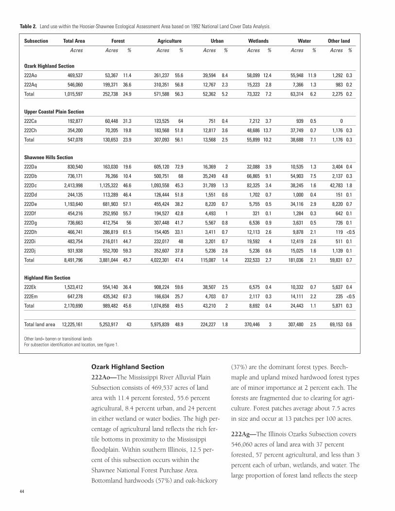
Ozark Highland Section
222Ao—The Mississippi River Alluvial Plain
Subsection consists of 469,537 acres of land
area with 11.4 percent forested, 55.6 percent
agricultural, 8.4 percent urban, and 24 percent
in either wetland or water bodies. The high per-
centage of agricultural land reflects the rich fer-
tile bottoms in proximity to the Mississippi
floodplain. Within southern Illinois, 12.5 per-
cent of this subsection occurs within the
Shawnee National Forest Purchase Area.
Bottomland hardwoods (57%) and oak-hickory
(37%) are the dominant forest types. Beech-
maple and upland mixed hardwood forest types
are of minor importance at 2 percent each. The
forests are fragmented due to clearing for agri-
culture. Forest patches average about 7.5 acres
in size and occur at 13 patches per 100 acres.
222Ag—The Illinois Ozarks Subsection covers
546,060 acres of land area with 37 percent
forested, 57 percent agricultural, and less than 3
percent each of urban, wetlands, and water. The
large proportion of forest land reflects the steep
44
Table 2. Land use within the Hoosier-Shawnee Ecological Assessment Area based on 1992 National Land Cover Data Analysis.
Subsection Total Area Forest Agriculture Urban Wetlands Water Other land
Acres Acres % Acres % Acres % Acres % Acres % Acres %
Ozark Highland Section
222Ao 469,537 53,367 11.4 261,237 55.6 39,594 8.4 58,099 12.4 55,948 11.9 1,292 0.3
222Aq 546,060 199,371 36.6 310,351 56.8 12,767 2.3 15,223 2.8 7,366 1.3 983 0.2
Total 1,015,597 252,738 24.9 571,588 56.3 52,362 5.2 73,322 7.2 63,314 6.2 2,275 0.2
Upper Coastal Plain Section
222Ca 192,877 60,448 31.3 123,525 64 751 0.4 7,212 3.7 939 0.5 0
222Ch 354,200 70,205 19.8 183,568 51.8 12,817 3.6 48,686 13.7 37,749 0.7 1,176 0.3
Total 547,078 130,653 23.9 307,093 56.1 13,568 2.5 55,899 10.2 38,688 7.1 1,176 0.3
Shawnee Hills Section
222Da 830,540 163,030 19.6 605,120 72.9 16,369 2 32,088 3.9 10,535 1.3 3,404 0.4
222Db 736,171 76,266 10.4 500,751 68 35,249 4.8 66,865 9.1 54,903 7.5 2,137 0.3
222Dc 2,413,998 1,125,322 46.6 1,093,558 45.3 31,789 1.3 82,325 3.4 38,245 1.6 42,783 1.8
222Dd 244,135 113,289 46.4 126,444 51.8 1,551 0.6 1,702 0.7 1,000 0.4 151 0.1
222De 1,193,640 681,903 57.1 455,424 38.2 8,220 0.7 5,755 0.5 34,116 2.9 8,220 0.7
222Df 454,216 252,950 55.7 194,527 42.8 4,493 1 321 0.1 1,284 0.3 642 0.1
222Dg 736,663 412,754 56 307,448 41.7 5,567 0.8 6,536 0.9 3,631 0.5 726 0.1
222Dh 466,741 286,819 61.5 154,405 33.1 3,411 0.7 12,113 2.6 9,878 2.1 119 <0.5
222Di 483,754 216,011 44.7 232,017 48 3,201 0.7 19,592 4 12,419 2.6 511 0.1
222Dj 931,938 552,700 59.3 352,607 37.8 5,236 2.6 5,236 0.6 15,025 1.6 1,139 0.1
Total 8,491,796 3,881,044 45.7 4,022,301 47.4 115,087 1.4 232,533 2.7 181,036 2.1 59,831 0.7
Highland Rim Section
222Ek 1,523,412 554,140 36.4 908,224 59.6 38,507 2.5 6,575 0.4 10,332 0.7 5,637 0.4
222Em 647,278 435,342 67.3 166,634 25.7 4,703 0.7 2,117 0.3 14,111 2.2 235 <0.5
Total 2,170,690 989,482 45.6 1,074,858 49.5 43,210 2 8,692 0.4 24,443 1.1 5,871 0.3
Total land area 12,225,161 5,253,917 43 5,975,839 48.9 224,227 1.8 370,446 3 307,480 2.5 69,153 0.6
Other land= barren or transitional landsFor subsection identification and location, see figure 1.
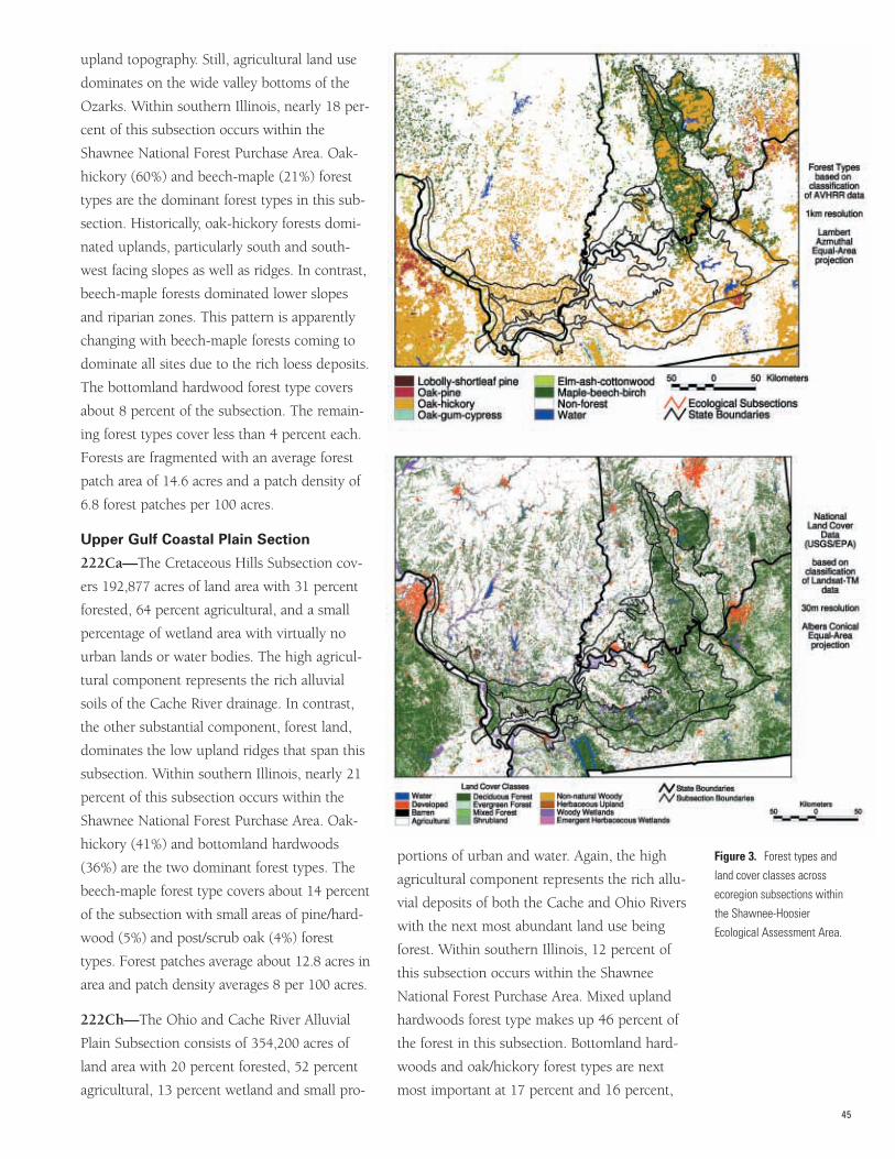
upland topography. Still, agricultural land use
dominates on the wide valley bottoms of the
Ozarks. Within southern Illinois, nearly 18 per-
cent of this subsection occurs within the
Shawnee National Forest Purchase Area. Oak-
hickory (60%) and beech-maple (21%) forest
types are the dominant forest types in this sub-
section. Historically, oak-hickory forests domi-
nated uplands, particularly south and south-
west facing slopes as well as ridges. In contrast,
beech-maple forests dominated lower slopes
and riparian zones. This pattern is apparently
changing with beech-maple forests coming to
dominate all sites due to the rich loess deposits.
The bottomland hardwood forest type covers
about 8 percent of the subsection. The remain-
ing forest types cover less than 4 percent each.
Forests are fragmented with an average forest
patch area of 14.6 acres and a patch density of
6.8 forest patches per 100 acres.
Upper Gulf Coastal Plain Section
222Ca—The Cretaceous Hills Subsection cov-
ers 192,877 acres of land area with 31 percent
forested, 64 percent agricultural, and a small
percentage of wetland area with virtually no
urban lands or water bodies. The high agricul-
tural component represents the rich alluvial
soils of the Cache River drainage. In contrast,
the other substantial component, forest land,
dominates the low upland ridges that span this
subsection. Within southern Illinois, nearly 21
percent of this subsection occurs within the
Shawnee National Forest Purchase Area. Oak-
hickory (41%) and bottomland hardwoods
(36%) are the two dominant forest types. The
beech-maple forest type covers about 14 percent
of the subsection with small areas of pine/hard-
wood (5%) and post/scrub oak (4%) forest
types. Forest patches average about 12.8 acres in
area and patch density averages 8 per 100 acres.
222Ch—The Ohio and Cache River Alluvial
Plain Subsection consists of 354,200 acres of
land area with 20 percent forested, 52 percent
agricultural, 13 percent wetland and small pro-
portions of urban and water. Again, the high
agricultural component represents the rich allu-
vial deposits of both the Cache and Ohio Rivers
with the next most abundant land use being
forest. Within southern Illinois, 12 percent of
this subsection occurs within the Shawnee
National Forest Purchase Area. Mixed upland
hardwoods forest type makes up 46 percent of
the forest in this subsection. Bottomland hard-
woods and oak/hickory forest types are next
most important at 17 percent and 16 percent,
45
Figure 3. Forest types and
land cover classes across
ecoregion subsections within
the Shawnee-Hoosier
Ecological Assessment Area.
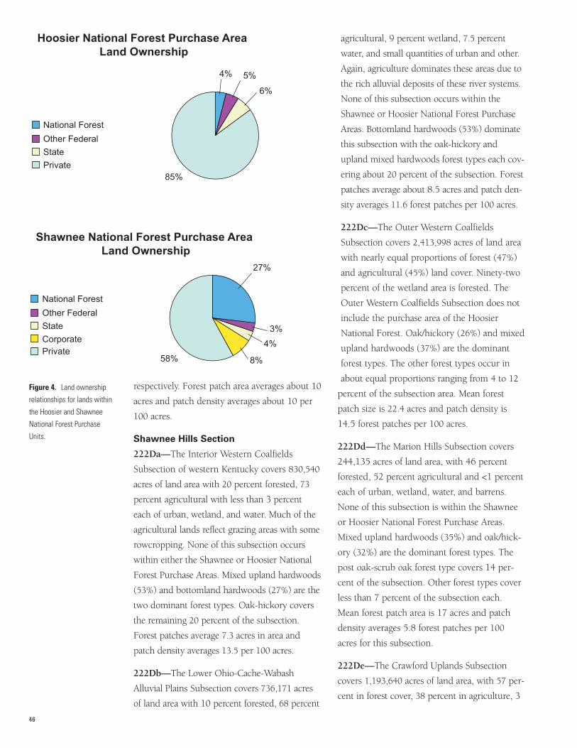
respectively. Forest patch area averages about 10
acres and patch density averages about 10 per
100 acres.
Shawnee Hills Section
222Da—The Interior Western Coalfields
Subsection of western Kentucky covers 830,540
acres of land area with 20 percent forested, 73
percent agricultural with less than 3 percent
each of urban, wetland, and water. Much of the
agricultural lands reflect grazing areas with some
rowcropping. None of this subsection occurs
within either the Shawnee or Hoosier National
Forest Purchase Areas. Mixed upland hardwoods
(53%) and bottomland hardwoods (27%) are the
two dominant forest types. Oak-hickory covers
the remaining 20 percent of the subsection.
Forest patches average 7.3 acres in area and
patch density averages 13.5 per 100 acres.
222Db—The Lower Ohio-Cache-Wabash
Alluvial Plains Subsection covers 736,171 acres
of land area with 10 percent forested, 68 percent
agricultural, 9 percent wetland, 7.5 percent
water, and small quantities of urban and other.
Again, agriculture dominates these areas due to
the rich alluvial deposits of these river systems.
None of this subsection occurs within the
Shawnee or Hoosier National Forest Purchase
Areas. Bottomland hardwoods (53%) dominate
this subsection with the oak-hickory and
upland mixed hardwoods forest types each cov-
ering about 20 percent of the subsection. Forest
patches average about 8.5 acres and patch den-
sity averages 11.6 forest patches per 100 acres.
222Dc—The Outer Western Coalfields
Subsection covers 2,413,998 acres of land area
with nearly equal proportions of forest (47%)
and agricultural (45%) land cover. Ninety-two
percent of the wetland area is forested. The
Outer Western Coalfields Subsection does not
include the purchase area of the Hoosier
National Forest. Oak/hickory (26%) and mixed
upland hardwoods (37%) are the dominant
forest types. The other forest types occur in
about equal proportions ranging from 4 to 12
percent of the subsection area. Mean forest
patch size is 22.4 acres and patch density is
14.5 forest patches per 100 acres.
222Dd—The Marion Hills Subsection covers
244,135 acres of land area, with 46 percent
forested, 52 percent agricultural and <1 percent
each of urban, wetland, water, and barrens.
None of this subsection is within the Shawnee
or Hoosier National Forest Purchase Areas.
Mixed upland hardwoods (35%) and oak/hick-
ory (32%) are the dominant forest types. The
post oak-scrub oak forest type covers 14 per-
cent of the subsection. Other forest types cover
less than 7 percent of the subsection each.
Mean forest patch area is 17 acres and patch
density averages 5.8 forest patches per 100
acres for this subsection.
222De—The Crawford Uplands Subsection
covers 1,193,640 acres of land area, with 57 per-
cent in forest cover, 38 percent in agriculture, 3
46
Figure 4. Land ownership
relationships for lands within
the Hoosier and Shawnee
National Forest Purchase
Units.
National Forest
Other Federal
State
Private
National Forest
Other Federal
State
CorporatePrivate
4% 5%
6%
85%
58%
27%
3%
4%
8%
Hoosier National Forest Purchase Area Land Ownership
Shawnee National Forest Purchase Area Land Ownership
percent in urban and 3 percent water or wet-
lands. Ninety-three percent of the wetland area
is forested. Thirty-nine percent of the Crawford
Uplands Subsection is within the purchase area
of the Hoosier National Forest. Of the purchase
area, 68 percent is forested, 28 percent is agri-
culture, 1 percent is urban, 2 percent is water or
wetland, and 1 percent is barren or transitional.
Oak-hickory (47%) and beech-maple (33%) are
the dominant forest types. The five other forest
types occurring in this subsection cover less
than 5 percent each. Mean forest patch area is
34.9 acres and patch density averages 2.9 forest
patches per 100 acres for this subsection.
222Df—The Crawford Escarpment Subsection
covers 454,216 acres of land area, with 56 per-
cent in forest cover, 43 percent in agriculture,
and 1 percent in urban. Less than 1percent is
water or wetlands. Twelve percent of the sub-
section is within the purchase area of the
Hoosier National Forest. Of the purchase area,
71 percent is in forest cover, 26 percent is agri-
culture, and 2 percent is urban. Oak-hickory
(44%) and beech/maple (34%) are the dominant
forest types. The other five forest types average
less than 7 percent each. Mean forest patch area
is 37.5 acres and patch density averages 2.6 for-
est patches per 100 acres.
47
Table 3. Forest area, mean forest patch area, patch area coefficient of variation, largest patch index, total edge, and total core area for each subsection based onFRAGSTATS analysis using AVHRR data.
Mean forest Patch area coefficient Largest Total core Subsection Total area Forest area patch area of variation patch index Total edge area
Acres Acres Acres Percent Percent Miles Acres
Ozark Highlands Section
222Ao 469,537 53,367 7 2,602 17.8 6,794 70,036
222Aq 546,060 199,371 15 5,273 41.3 9,206 147,652
Upper Gulf Coastal Plain Section
222Ca 192,877 60,448 13 3,556 49.3 2,943 45,156
222Ch 354,200 70,205 10 1,490 6.8 6,645 65,143
Shawnee Hills Section
222Da 830,540 163,030 7 3,126 16.6 12,812 116,830
222Db 736,171 76,266 9 1,587 8.0 9,411 84,809
222Dc 2,413,998 1,125,322 22 11,661 40.1 42,334 899,073
222Dd 244,135 113,289 17 3,933 43.2 5,411 74,885
222De 1,193,640 681,903 35 5,208 23.3 21,941 513,775
222Df 454,216 252,950 38 2,390 16.9 8,505 196,560
222Dg 736,663 412,754 24 6,948 42.5 13,815 323,676
222Dh 466,741 286,819 45 5,661 63.3 7,247 244,111
222Di 483,754 216,011 20 4,813 43.2 9,472 157,351
222Dj 931,938 552,700 26 12,691 87.2 17,876 426,189
Highland Rim Section
222Ek 1,523,412 554,140 13 5,035 22.9 26,949 358,152
222Em 647,278 435,342 66 6,494 79.5 9,804 359,560
FRAGSTATS is a software program for determining spatial parameters of land areas.AVHRR= Advanced Very High Resolution Radiometer.Largest patch index is the percent of the forest area in the largest patch.Core area is based on a 30-meter edge. For subsection identification and location, see figure 1.
222Dg—The Southern Dripping Springs
Subsection covers 736,663 acres of land area
with 56 percent forested, 42 percent agricultur-
al and <1 percent each of urban, wetland, and
water. None of this subsection occurs within
national forest purchase area boundaries. Mixed
upland hardwoods (51%) and oak-hickory
(27%) are the most widespread forest types.
Post oak-southern scrub oak forest covers about
20 percent of the subsection. The pine-cedar,
pine-hardwoods, and bottomland hardwoods
forest types each cover 6 percent or less of this
subsection. Mean forest patch area is 23.6 acres
and patch density averages 4 per 100 acres.
222Dh—The Greater Shawnee Hills Subsection
covers 466,741 acres of land area with 62 per-
cent forest, 33 percent agricultural, and less
than 3 percent urban, wetland, and water each.
The high percentage of forest land reflects the
steep uplands of the region, which support less
agricultural land than the adjacent Lesser
Shawnee Hills Subsection. Eighty-six percent of
this subsection lies within the Shawnee
National Forest Purchase Area. Oak-hickory
(62%) is the dominant forest type with beech-
maple (12%) and bottomland hardwoods (10%)
the next most widespread forest types. The
other four forest types present in the subsection
48
Table 4. Comparison of AVHRR and FIA land area data by subsection for the Hoosier-Shawnee Ecological Assessment Area.
Total area Forest area Percent forest
Subsection AVHRR FIA Difference AVHRR FIA Difference AVHRR FIA Difference
--------- Acres -------- Percent -------- Acres ------- Percent ---------------- Percent -------------
Ozark Highland Section
222Ao 469,537 422,723 10 53,367 83,427 36.0 11.4 19.7 8.3
222Aq 546,060 554,369 1.5 199,371 212,795 6.0 36.5 39.5 3.1
Upper Coastal Plain Section
222Ca 192,877 173,866 9.9 60,448 68,651 12.1 31.3 39.5 8.3
222Ch 354,200 363,542 2.6 70,205 98,106 28.4 19.8 27.0 7.2
Shawnee Hills Section
222Da 830,540 815,270 1.8 163,030 191,203 14.7 19.6 23.5 3.9
222Db 736,171 735,665 0.1 76,266 114,485 33.4 10.4 15.6 5.2
222Dc 2,413,998 2,409,332 0.2 1,125,322 1,027,527 8.7 46.6 42.6 4
222Dd 244,135 229,372 6 113,289 120,855 6.3 46.4 52.7 6.3
222De 1,193,640 1,184,125 0.8 681,903 705,121 3.3 57.1 59.5 2.4
222Df 454,216 399,305 12.1 252,950 234,238 7.4 55.7 58.7 3.3
222Dg 736,663 781,399 5.7 412,754 329,859 20.1 56.0 42.2 3.8
222Dh 466,741 480,148 2.8 286,819 267,528 6.7 61.5 55.7 5.7
222Di 483,754 478,827 1 216,011 214,067 0.9 44.7 44.7 0.2
222Dj 931,938 916,921 1.6 552,700 514,563 6.9 59.3 56.1 3.2
Highland Rim Section
222Ek 1,523,412 1,437,039 5.7 554,140 417,949 24.6 36.4 29.1 7.3
222Em 647,278 594,270 8.2 435,342 392,016 10.0 67.3 66.0 1.3
Total land area 12,225,161 11,976,173 9.8 5,253,917 4,992,389 9.5 43.0 41.7 1.3
AVHRR= Advanced Very High Resolution Radiometer, FIA= Forest Inventory and Analysis. For subsection identification and location, see figure 1.
cover less than 5 percent each. Mean forest
patch area is 45.5 acres and patch density aver-
ages 2.2 patches per 100 acres.
222Di—The Lesser Shawnee Hills Subsection
covers 483,754 acres of land area with 45 per-
cent forested, 48 percent agricultural, and
small proportions of wetland and urban areas.
Forty-seven percent of this subsection lies
within the Shawnee National Forest Purchase
Area. Oak-hickory (57%) is the dominant for-
est type with beech-maple (15%) and bottom-
land hardwoods (10%) the next most wide-
spread forest types. The other four forest types
found in this subsection average less than 6
percent each. Mean forest patch area is 19.6
acres and patch density averages 5 forest
patches per 100 acres.
222Dj—The Northern Dripping Springs
Subsection covers 931,938 acres of land area
with 59 percent forest, 38 percent agricultural,
and 3 percent urban. None of this subsection
occurs within either of the national forest pur-
chase areas. Mixed upland hardwoods (54%)
dominate with oak-hickory (18%) and beech-
maple (9%) the next most widespread forest
types. The other four forest types present aver-
age 6 percent or less each. Mean forest patch
area is 26.2 acres and patch density averages 3.7
forest patches per 100 acres.
Highland Rim Section
222Em—The Brown County Hills Subsection
covers 647,278 acres of land area. Land use in
this subsection is 67 percent forest cover, 26
percent agriculture, 2 percent urban, and 2 per-
cent water. Ninety-nine percent of the forest
cover is deciduous, and the remainder is in
coniferous or mixed deciduous/conifer forest.
Twenty-two percent of the Brown County Hills
Subsection is within the purchase area of the
Hoosier National Forest. Land use within the
purchase area is 80 percent forest cover, 13 per-
cent agriculture, less than 1 percent urban, and
6 percent water.
Oak-hickory (31%), beech-maple (27%), and
mixed upland hardwoods (22%) are the domi-
nant forest types. The other four forest types
cover 7 percent or less of the subsection
each. Mean forest patch area is 12.8 acres and
patch density averages 8.1 forest patches per
100 acres.
222Ek—The Mitchell Karst Plain Subsection
covers 1,523,412 acres of land area with 36 per-
cent in forest cover, 60 percent in agriculture,
and 2.5 percent urban. Less than 1 percent is
water or wetland. Seventy-two percent of the
forest cover is deciduous, and the remainder is
in coniferous or mixed deciduous/conifer forest.
Less than 1 percent (3,676 acres) of the Mitchell
Karst Plain Subsection is within the purchase
area of the Hoosier National Forest. Land use
within the purchase area is 78 percent forested,
22 percent agriculture, and 3 percent urban.
Oak-hickory (60%) and beech-maple (24%) are
the dominant forest types. The other five forest
types average less than 6 percent of the subsec-
tion each. Mean forest patch area is 66 acres
and patch density averages 1.5 forest patches
per 100 acres.
Forest Age Across the Region This section examines the current age structure
of forests across the region. Although most of
the forests in the region are relatively young
due to the widespread clearing of the late
1800s and early 1900s, old-growth forests
(>150 years in age) are expected to dramatical-
ly increase in spatial area under current man-
agement practices. Forest patches (>5 acres in
size) less than 10 years of age are declining in
area across the assessment area.
Most of the timberland within the assessment
area is less than 100 years of age, reflecting the
major logging activities at the turn of the 20th
century (Clark 1987, Schmidt et al. 2000,
Tormoehlen et al. 2000). In Indiana, 81 percent
of the timberland in the Knobs Unit is between
31 and 100 years of age and 80 percent of the
49
Lower Wabash Unit falls within this age range.
Only 6 percent of the timberland within the
Knobs Unit and 2.8 percent of the Lower
Wabash Unit exceed 100 years of age. Forests
less than 10 years of age account for 2 percent
of the Knobs Unit and 1.2 percent of the
Lower Wabash Unit. Timberland exceeding
100 years of age is 1.2 percent of the land
within the Hoosier National Forest and tim-
berland less than 10 years of age is 1 percent.
The acreage of forests in older age classes
within the assessment area is expected to dra-
matically increase due to current management
systems and areas protected from harvest. Old-
growth forests on public lands within Indiana
are expected to increase from 895 to 136,450
acres over the next 50 years (Parker 1989,
Spetich et al. 1997). Most of this additional
old forest (99,090 acres) will be within the
Hoosier National Forest. Forests less than 10
years of age are expected to decrease under
current management systems.
Age structure across the ecological sections of
southern Illinois was investigated by stratify-
ing FIA forest type data into 20-year age class-
es and assigning a midrange age to these
stands, i.e., for the 21- to 40-year age class,
the median age of establishment would be 30
years ago, approximately 1970. These data
revealed that across sections less than 10 per-
cent of the current forest land was established
before 1900 indicating very little of the land-
scape is in old-growth condition (fig. 5). A
rough estimate of old growth is 3 to 5 percent
of the current forest land (Ruffner, personal
observation). Across the region, many stands
originated between the 1930s and 1950s with
a slight decrease in cutting around 1970 (fig.
5). The Ozark Highlands and the Upper Gulf
Coastal Plain Sections have experienced more
recent cutting, whereas the Shawnee Hills and
Highland Rim Sections have seen a drop in
recently established forest stands.
RECENT TRENDS IN FORESTMANAGEMENTThis section is a review of the literature on the
ecological implications of current forest man-
agement trends. The general trend in manage-
ment across the region has been to minimize
disturbance through complete protection or
drastic reduction in harvest opening size. There
has also been an increase in the use of pre-
scribed burning in some fire-dependent com-
munities. Protection from disturbance is likely
to hasten the transition of species and will like-
ly result in a loss of biological diversity across
the region (Loucks 1970, Thompson and
Dessecker 1997).
Major management initiatives of the 20th centu-
ry are primarily responsible for the forest devel-
opment pathways that created the current forest
cover of the assessment area. At the end of the
19th century, much of the area was recovering
from widespread cutting for numerous products
(Fralish 1997, Ruffner et al. 2002), rampant
grazing and forest burning (Miller 1920), and
poor agricultural practices (Fralish 1997). The
first major initiative saw the reforestation of
many abandoned old fields and pastures, and
much of the burned and grazed over lands,
with the introduction of nonnative pine species.
Reforestation of abandoned lands and reduced
grazing of forests have reduced landscape frag-
mentation, particularly in areas with large pub-
lic ownership (Spetich et al. 1997) and have
generally improved the condition of forests
across the region.
Coupled with reforestation and reduced graz-
ing was the control and suppression of fires on
the landscape. With the organization of State
forestry divisions in the 1920s, the Civilian
Conservation Corps (1930-1941), and eventu-
ally the full resources of the USDA Forest
Service in 1933, an aggressive fire suppression
campaign was begun. At the time, managers
were acting under accepted concepts and pro-
cedures that suggested a healthy vibrant forest
50
must be protected from the damaging scourge
of wildfire. Even though numerous people (liv-
ing at the time) must have experienced and
appreciated the long-term effects of introduced
fire in the early part of the 20th century, an
active fire monitoring system was developed.
Fire towers were constructioned, old logging
roads were maintained and improved for fire
access, and a general public relations campaign
was begun to alert the populace to the need for
these activities.
At the time of these efforts, the important role
of recurring disturbances in the maintenance of
oak-hickory forests was poorly understood
(Abrams 1992, Lorimer 1985, Schlesinger
1976). These authors, and many others, have
contributed greatly to our knowledge of the his-
torical development of these ecosystems. It is
generally accepted that the numerous distur-
bances of the post-European settlement period
fostered the expansion of oak-hickory in the
eastern deciduous biome (Abrams 1992,
Lorimer 1992). Indeed, the frequent cutting
regime, coupled with fire and grazing, of south-
ern Illinois, southern Indiana, and western
Kentucky that fed stave mills, charcoal iron fur-
naces, railroad expansions, and the cottage
industries that produced fences, fruit contain-
ers, clapboards, and building timbers for the
rapidly growing region is largely responsible for
the mixed oak-dominated forests across the
study region.
However, the fire cessation of the early 20th
century fostered the expansion of mixed meso-
phytic species across the region (Fralish et al.
1991). Numerous authors have studied these
central hardwood old-growth stands typified by
the cessation of cutting, burning, and most
forms of management (Barton and Schmelz
1987, Fralish et al. 1991, Fralish 1997,
Groninger et al. 2002, Martin 1992, Nelson et
al. 1973, Robertson and Heikens 1994, Ruffner
et al. 2002, Schlesinger 1976, Spetich 1995,
Weaver and Ashby 1971, Zaczek et al. 2002).
51
Figure 5. Stand age classes across ecoregions within the Shawnee-Hoosier
Ecological Assessment Area.
Across the spectrum of sites in the assessment
area, these studies report significant shifts in
species composition and forest structure.
Overwhelmingly, sugar maple and American
beech are found to be increasing in stand den-
sity and basal area at the expense of the oak-
hickory overstory. Age-diameter figures suggest
that a large cohort of mixed maple, beech, ash,
and gum was recruited only a few years after
the control of understory fire and the elimina-
tion of harvesting across forests of the Ozark
Hills, Shawnee Hills, and Highland Rim
(Parker 1989, van de Gevel and Ruffner 2002,
Zaczek et al. 2002).
Although a complete database of harvest
removals for the assessment area does not exist
at this time, it is possible to chronicle the
major forest management activities of the mid-
dle to late 20th century. By the middle to late
1960s, most forest management agencies had
adopted clearcutting as the preferred regenera-
tion method for forests of the region (Illinois
Technical Forestry Association 1965, Mills et al.
1987). Success of these clearcuts is equivocal
based on the variability of site characteristics
such as land use history, soils, and species
composition (Fralish et al. 1991, Gleason
1926). Depending on the date of fire cessation,
many of these clearcuts did not result in regen-
eration of oak as planned but merely released
the advanced regeneration pool in the transi-
tional maple-beech understory (Abrams and
Scott 1989, Fralish 1997, Groninger et al. 2002,
Heiligmann et al. 1985). In general, clearcut-
ting on upland sites has failed to regenerate
oak when adequate advanced regeneration of
oak was not in place at the time of harvest
(Sanders and Graney 1992). However, oak
seedlings and sprouts are usually present in
young stands following clearcutting but are
overtopped by other faster growing species
within a few years (George and Fischer 1991,
Jenkins and Parker 1998), indicating the need
for additional cultural treatments such as
applying herbicide, thinning, or prescribed
burning to reduce the competition of these
faster growing stems.
The successful regeneration of oak was further
reduced by the adoption of group selection
cutting in the mid- to late-1980s, despite the
reported failure of previous attempts to main-
tain oak through uneven-aged management
options. Under this management scheme,
small multistem groups were harvested in an
attempt to reduce the visual impact of
clearcuts on the landscape. While these altered
harvest methods may have reduced the visual
impact and quieted clearcutting opponents,
many ultimately hastened the replacement of
oak-hickory forests by later successional
species in the small patches (≤0.5 acre) that
were created (Fralish 1997, Groninger et al.
2002, Nelson et al. 1973, Ruffner et al. 2002,
Weigel and Parker 1997, Zaczek et al. 2002).
Group selection openings may vary from 0.5
to 5 acres in size. The larger openings are
capable of providing a light regime more
favorable to midtolerant species such as oaks
(Jenkins and Parker 1997). Group selection
(ranging in size between 1 and 5 acres) is the
predominant silvicultural system used in
Indiana State Forests (Indiana Department of
Natural Resources 2001), but no timber cut-
ting is occurring in the State forests of Illinois.
Because of these preliminary experiments,
managers now understand that regeneration
methods must be based on an evaluation of
the oak regeneration potential (Sanders and
Graney 1992). Where oak reproduction is low,
stand treatments to enhance oak establishment
and growth are needed. Where oak reproduc-
tion is adequate, clearcutting is the best
method to use (Sanders and Graney 1992). In
stands with little or no oak reproduction, the
shelterwood method is probably the only one
that will succeed in regenerating oaks (Sanders
and Graney 1992, Van Lear and Watt 1992).
However, success depends on quality of the
52

site and application of additional treatments to
reduce competition (Brose et al. 2001).
Perhaps the most successful experiments to
date include those in forests of the Piedmont
region of Virginia (Brose and Van Lear 1998,
Brose et al. 2001, Keyser et al. 1996). Following
shelterwood harvests with a 50 percent basal
area reduction, these authors conducted repeat-
ed prescribed burns to significantly reduce
tulip-poplar regeneration and increase advanced
oak regeneration. They suggested that this har-
vest/fire disturbance regime closely mimics the
conditions that fostered the development of
these oak-dominated systems (Brose et al.
2001). In addition, they reported a critical need
for several years between the initial cut and
burning. This waiting period allows for several
key components including the establishment
and growth of vigorous oak seedlings and the
regeneration of the buried tulip-poplar seed
pool. Although burns were conducted in the
winter and summer, spring appeared to be the
best time for burning because it presented the
most favorable weather conditions such as
warm temperatures, lower humidities, and
sunny days (Brose et al. 2001).
Within forests of southern Illinois, land man-
agers have been using prescribed fire since the
mid-1980s. Although the USDA Forest Service
fire management program has largely been
forced into a “suppression” mode due to exten-
sive analysis requirements, several Illinois
Department of Natural Resources divisions
actively manage vegetation with prescribed fire
(Ruffner 2001). The Divisions of Forestry and
Natural Heritage both use fire to maintain
unique vegetation and habitat types in glade
and oak savannas, improve wildlife habitat, and
foster oak regeneration while reducing compet-
ing mesophytic species in forest lands (Ruffner
2001). New research initiatives have been devel-
oped to provide empirical data that monitor
long-term vegetation dynamics within burned
forests of southern Illinois (Allen 2001, Ruffner
and Davis 2002). State forestry officials in
cooperation with ecologists and silviculturists
at Southern Illinois University have begun a
landscape-scale study to test the effects of
timber stand improvement with fire in upland
oak stands of the Shawnee and Cretaceous
Hills (Allen 2001; Ruffner, personal observa-
tion). These researchers hope that substantial
removals of understory and midstory
mesophytes, coupled with the application of
prescribed fire for 3 to 5 years following
removals, will increase advanced oak regenera-
tion at the expense of later successional species.
53
LITERATURE CITED
Abrams, M.D. 1992.
Fire and the development of oaks. Bioscience. 42:
346-353.
Abrams, M.D.; Scott, M.L. 1989.
Disturbance mediated accelerated succession in two
Michigan forest types. Forest Science. 35: 42-49.
Abrams, M.D.; Orwig, D.A.; DeMeo,T.E. 1995.
Dendroecology and successional dynamics of a pre-
settlement-origin white pine-mixed oak forest in the
southern Appalachians, USA. Journal of Ecology. 83:
122-133.
Abrams, M.D.; Orwig, D.A.; Dockry,M.J. 1997.
Dendroecology and successional status of two
contrasting old-growth oak forests in the Blue Ridge
Mountains, USA. Canadian Journal of Forest
Ressearch. 27: 994-1002.
Allen, D. 2001.
Forest Stewardship Plan, Dixon Springs Agricultural
Center, Illinois Forest Resource Center. Unpubl. Rep.,
Golconda, IL: Illinois Department of Natural
Resources. 22 p.
Allen, J.W. 1945.
Jackson County notes. Contrib. 21. Carbondale, IL:
Southern Illinois University, Museum of Natural and
Social Sciences.
Anderson, R.C.; Anderson, R. 1975.
Presettlement vegetation of Williamson County,
Illinois. Castanea. 40: 345-363.
Anderson, R.C.; Schwegman, J.E.;
Anderson, M.R. 2000.
Micro-scale restoration: a 25-year history of a south-
ern Illinois barrens. Restoration Ecology. 8: 296-306.
Ashby, W.C.; Kelting, R.W. 1963.
Vegetation of the pine hills field station in
Southwestern Illinois. Transactions Illinois Academy
of Science. 56: 188-201.
Attiwil, P.W. 1994.
The disturbance of forest ecosystems: the ecological
basis for conservation management. Forest Ecology
and Management. 63: 247-300.
Bacone, J.A.; Casebere, L.A. 1983.
Glades and Barrens of Crawford and Perry County
Indiana. Indiana Academy of Science. 92: 367-373.
Barton, J.D.; Schmelz, D.V. 1987.
Thirty years of growth records in Donaldson’s woods.
Proceedings of the Indiana Academy of Science. 96:
209-213.
Black, B.A.; Abrams, M.D. 2001.
Influences of Native Americans and surveyor bias on
metes and bounds witness-tree distribution. Ecology.
82: 2574-2586.
Braun, E.L. 1950.
Deciduous forests of eastern North America. New
York, NY: Mc Millan. 596 p.
Brose, P.H.; Van Lear, D.H. 1998.
Responses of hardwood advance regeneration to
seasonal prescribed fires in oak-dominated shelter-
wood stands. Candian Journal of Forest Research.
28: 331-339.
Brose, P.; Schuler, T.; Van Lear, D.;Berst, J. 2001.
Bringing fire back: the changing regimes of the
Appalachian mixed-oak forests. Journal of Forestry.
99 (11): 30-35.
Brown, M.K. 1985.
The historic period. Porter, J.W.; Rohn, D.S., eds.
Illinois Archaeology Bulletin 1: Revised: 89-100.
Brundage, R.C. 1934.
Marketing crossties and piling in Southern Indiana.
Bull. 395. West Lafayette, IN: Purdue University,
Agriculture Experiment Station. 50 p.
Brundage, R.C. 1936.
Marketing timber for basket stock in Indiana. Bull.
408. West Lafayette, IN: Purdue University,
Agriculture Experiment Station. 30 p.
Brundage, R.C. 1937.
Marketing timber for handle stock in Indiana. Bull.
424. West Lafayette, IN: Purdue University,
Agriculture Experiment Station. 36 p.
Caldwell, J.R. 1958.
Trend and tradition in the prehistory of eastern United
States. Memoir 88. Springfield, IL: American
Anthropological Association. 88 p.
Canham, C.D. 1985.
Suppression and release during canopy recruitment in
Acer saccharum. Bulletin of the Torrey Botanical Club.
112: 134-145.
Chapman, J.; Delcourt, P.A.;Cridlebaugh, P.A.; Shea, A.B.;
Delcourt, H.R. 1982.
Man-land interaction: 10,000 years of American
Indian impact on native ecosystems in the Lower
Little Tennessee River Valley, eastern Tennessee.
Southeastern Archaeology. 1: 115-121.
Clark, D. Lee. 1987. Entrepreneurs in Hardwoods: a study of small business
strategies. Indianapolis, IN: White Arts, Inc. 208 p.
Clark, G.R. [1920].
The conquest of the Illinois. Quaife, M.M., ed. 2001
reprint ed. Carbondale, IL: Southern Illinois University
Press. 192 p.
Clark, J.S.; Royall, P.D. 1995.
of a northern hardwood forest by aboriginal (Iroquois)
fire: charcoal evidence from Crawford Lake, Ontario,
Canada. The Holocene. 5: 1-9.
Cole, F.C. 1951.
Kincaid a prehistoric Illinois metropolis. Chicago, IL:
University of Chicago Press. 385 p.
Conrad, D.E. 1978.
The land we cared for: a history of the Forest
Service’s Eastern Region. Milwaukee, WI: U.S.
Department of Agriculture, Forest Service. 312 p.
Davis, M.E.; Ruffner C.M. 2001.
Fire history and successional dynamics of shortleaf
pine-mixed oak forests at LaRue Pine Hills RNA,
southern Illinois. Denver, CO: Society of American
Foresters, annual conference. Abstract.
Delcourt, H.R. 1987.
The impact of prehistoric agriculture and land occupa-
tion on natural vegetation. TREE. 2: 39-44.
Delcourt, P.A.; Delcourt, H.R.; Ison,C.R.; Sharp, W.E.; Gremillion, K.J.
1998.
Prehistoric human use of fire, the eastern agricultural
complex, and Appalachian oak-chestnut forests:
Paleoecology of Cliff Palace Pond, Kentucky.
American Antiquity. 63: 263- 278.
54
Denevan, W.M. 1992.
The pristine myth: the landscape of the Americas in
1492. Annals of the Association of American
Geographers. 82(3): 369-385.
DenUyl, D. 1961.
Natural reproduction in mixed hardwood stands. Res.
Bull. 728. West Lafayette, IN: Purdue University,
Agriculture Experiment Station. 19 p.
DenUyl, D. 1954.
Indiana’s old growth forests. Proceedings of the
Indiana Academy of Science. 63: 73-79.
DenUyl, D. 1947.
Forest grazing in the central states region.
Proceedings, Society of American Foresters. 255-261.
DenUyl, D.; Day, R.K. 1939.
Woodland livestock carrying capacities and grazing
injuries studies. Bull. 391. West Lafayette, IN: Purdue
University, Agriculture Experiment Station. 16 p.
Eagleman, J.P. 1981.
Washington Township: the Brown County forest story.
DePaul University. 132 p. M.A. thesis.
Evers, R.A. 1955.
Hill Prairies of Illinois. Bulletin State of Illinois
Natural History Survey Division. 26: 367-446.
Fenneman, N.M. 1938.
Physiography of eastern United States. New York, NY:
McGraw-Hill. 714 p.
Fowells, H.A., ed. 1965. Silvics of Forest Trees of the United States. Agric.
Handb. 271. Washington, DC: U.S. Department of
Agriculture, Forest Service. 762 p.
Fralish, J.S. 1988.
Predicting potential stand composition from site char-
acteristics in the Shawnee Hills forest of Illinois.
American Midland Naturalist. 120: 79-101.
Fralish, J.S. 1997.
Community succession, diversity, and disturbance in
the central hardwood forest. In: Schwartz, M.K., ed.
Conservation in highly fragmented landscapes. New
York, NY: Chapman and Hall: 234-266.
Fralish, J.S.; Crooks, F.B.; Chambers,J.L.; Harty, F.M. 1991. Comparison of presettlement, second-growth and old-
growth forest on six site types in the Illinois Shawnee
Hills. American Midland Naturalist. 125: 294-309.
Fralish, J.S.; Franklin, S.B.; Close,D.D. 1999.
Open woodland communities of southern Illinois,
western Kentucky, and middle Tennessee. Savannas,
barrens, and rock outcrop plant communities of North
America. Cambridge, UK: Cambridge University Press:
171-189.
Franklin, S.B. 1994.
Late Pleistocene and Holocene vegetation history of
Land Between the Lakes, Kentucky and Tennessee.
Transaction of Kentucky Academy of Science. 55(1-2):
6-19.
Freeman, W.H. 1908.
Eight annual report: State Board of Forestry.
Indianapolis, IN. 211 p.
Gardner, P.S. 1997.
The ecological structure and behavioral implications
of mast exploitation strategies. In: Gremillion, K.J.,
ed. Peoples, places, and landscapings: studies in
paleoethnobotany. Tuscaloosa, AL: University of
Alabama Press: 161-178.
George, D.W.; Fischer, B.C. 1991.
The occurrence of oak reproduction after clearcut har-
vesting on the Hoosier National Forest. Northern
Journal of Applied Forestry. 8: 144-146.
Gleason, H.A. 1926. The individualistic concept of plant succession.
Bulletin of the Torrey Botanical Club. 44: 463-481.
Gordon, R.B. 1936.
A preliminary vegetation map of Indiana. American
Midland Naturalist. 17: 866-877.
Groninger, J.W.; Ozier, T.B.; Ruffner,C.M. 2003.
Stand compositional dynamics in a mature Illinois
Ozark Forest: implications for management. In:
Proceedings 13th Central hardwoods forest confer-
ence; Urbana-Champaign, IL. Gen. Tech. Rep. NC-234.
St. Paul, MN: U.S. Department of Agriculture, Forest
Service, North Central Research Station: 296-302.
Guyette, R.; Cutter, B. 1991.
Tree-ring analysis of fire history of a post oak savan-
na in the Missouri Ozarks. Natural Areas Journal. 11:
93-99.
Guyette, R.; Dey, D. 2000.
Notes on the fire history of a southern Indiana oak
barrens. Unpublished report.
Hall, C.; Ingall, O.D. 1910.
Forest conditions in Illinois. Springfield, IL: Illinois
State Laboratory of Natural History: 175-253.
Harty, F.M. 1978.
Tree species distribution, and herbaceous vegetation
as an indicator of site quality for disturbed upland for-
est stands in the Greater Shawnee Hills of southern
Illinois. Carbondale, IL: Southern Illinois University.
M.S. thesis.
Hedge, Roger L. 1997.
Sandhills and old till: the Southwestern Lowlands
Natural Region. In: Jackson, Marion T., ed. The
Natural Heritage of Indiana. Bloomington, IN: Indiana
University Press: 184-187.
Heikens, A.L.; Robertson, P.A. 1995.
Classification of barrens and other natural xeric forest
openings in southern Illinois. Bulletin of the Torrey
Botanical Club. 122: 203-214.
Heiligmann, R.B.; Norland, E.R.;Hilt, D.E. 1985.
28-year-old reproduction on five cutting practices in
upland oak. Northern Journal of Applied Forestry. 2:
11-13.
Homoya, M.A. 1994.
Indiana Barrens: classification and description.
Castanea. 59: 204-213.
Homoya, M.A. 1997.
Land of the cliff dwellers: the Shawnee Hills Natural
Region. In: Jackson, Marion T., ed. The Natural
Heritage of Indiana. Bloomington, IN: Indiana
University Press: 172-176.
Homoya, M.A.; Huffman, H. 1997.
Sinks, slopes and a stony disposition: the Highland
Rim Natural Region. In: Jackson, Marion T., ed. The
Natural Heritage of Indiana. Bloomington, IN: Indiana
University Press: 167-171.
Illinois Technical ForestryAssociation. 1965.
Recommended silviculture and management practices
for Illinois hardwood forest types. Springfield, IL: 46 p.
Indiana Department of NaturalResources. 2001.
Indiana state forest procedures manual. Indianapolis,
IN: Indiana Department of Natural Resources,
Division of Forestry. Unpublished.
55
Jenkins, M.A.; Parker, G.R. 1998.
Composition and diversity of woody vegetation in sil-
vicultural openings in southern Indiana. Forest
Ecology and Management. 109: 57-74.
Jenkins, M.A.; Parker, G.R. 2000.
Changes in the landscape of the Charles C. Deam
Wilderness, southern Indiana, 1939-1990. Natural
Areas Journal. 20: 46-55.
Jenkins, M.A.; Parker, G.R. 2001.
Woody species composition of disturbed forests in
intermittent stream bottomlands of southern Indiana.
Journal of the Torrey Botanical Society. 128: 165-175.
Keys, J., Jr.; et al. 1995.
Ecological units of the eastern United States-first
approximation (map and booklet of map unit tables).
Atlanta, GA: U.S. Department of Agriculture, Forest
Service. 83 p.
Keyser, P.D.; Brose, P.H.; Van Lear,D.H.; Burtner, K.M. 1996.
Enhancing oak regeneration with fire in shelterwood
stands: preliminary trials. Transactions of the North
American Wildlife Natural Resource Conference. 61:
215-219.
Kimmerer, R. Wall; Lake, F.Kanawha. 2001. The role of indigenous burning in land management.
Journal of Forestry. 99(11): 36-41.
Küchler, A.W. 1964.
Potential natural vegetation of the conterminous
United States. New York, NY: American Geographical
Society. Map.
Latta, W.C. 1932.
Outline history of Indiana agriculture. West Lafayette,
IN: Purdue University, Agriculture Experiment Station.
372 p.
Leitner, L.A.; Jackson, M.T. 1981.
Presettlement forests of the unglaciated portion of
southern Illinois. American Midland Naturalist.
105(2): 291-304.
Lindsey, A.A. 1962.
Analysis of an original forest of the lower Wabash
floodplain and upland. Proceedings of the Indiana
Academy of Science. 72: 282-287.
Lindsey, A.A.; Schmelz, D.V. 1965.
Comparison of Donaldson’s Woods in 1964 with its
1954 forest map of 20 acres. Proceedings of the
Indiana Academy of Science. 74: 169-177.
Lindsey, A.A.; Schmelz, D.V. 1970.
The forest types of Indiana and a new method of clas-
sifying Midwestern hardwood forests. Proceedings
Indiana Academy of Science. 79: 198-204.
Lindsey, A.A.; Schmelz, D.V.;Nichols, S.A. 1969.
Natural areas in Indiana and their preservation.
Indiana Natural Areas Survey, Dept. of Biological
Science, Purdue Univ., reprinted American Midland
Naturalist, 1970. 594 p.
Lindsey, A.A.; Crankshaw, W.B.;Qadir, S.A. 1965.
Soil relations and distribution map of the vegetation
of presettlement Indiana. Botanical Gazette. 126(3):
155-163.
Lorimer, C.G. 1985.
The role of fire in the perpetuation of oak forests. In:
Johnson, J.E., ed. Challenges in oak management and
utilization. Madison, WI: Cooperative Extension
Service, University of Wisconsin: 8-25.
Lorimer, C.G. 1992.
Causes of the oak regeneration problem. In: Loftis,
D.L.; McGee, C.E., eds. Oak regeneration: serious
problems, practical recommendations. Gen. Tech.
Rep. SE-84. Asheville, NC: U.S. Department of
Agriculture, Forest Service, Southeastern Forest
Experiment Station: 14-39.
Loucks, O.L. 1970.
Evolution of diversity, efficiency and community sta-
bility. Amererican Zoologist.10: 17-25.
Martin, W.H. 1991.
The role and history of fire in the Daniel Boone
National Forest. Winchester, KY: Daniel Boone
National Forest. 131 p. Unpublished report.
Martin, W.H. 1992.
Characteristics of old-growth mixed mesophytic
forests. Natural Areas Journal. 12: 127-135.
McArdle, T.G. 1991.
Comparison of presettlement and present forest com-
munities by site type in the Illinois Ozark Hills.
Carbondale, IL: Southern Illinois University. M.S. thesis.
McCall, R.K.; Gibson, D.J. 1999.
The regeneration potential of a threatened southern
Illinois shale barren. Journal of the Torrey Botanical
Society. 126: 226-233.
McConnell, M.N. 1992.
A country between: the upper Ohio valley and its peo-
ples, 1724-1774. Lincoln, NE: University of Nebraska
Press. 357 p.
McCord, S. 1970.
Travel accounts of Indiana: 1679-1961. Indiana
Historical Bureau. 331 p.
McCune, B.; Menges, E.S. 1986.
Quality of historical data in midwestern old-growth
forests. American Midland Naturalist. 116: 163-172.
McGarigal, K.; Marks B.J. 1994.
FRAGSTATS: spatial pattern analysis program for
quantifying landscape structure (v2.0). Gen. Tech.
Rep. PNW-351. Portland, OR: U.S. Department of
Agriculture, Forest Service, Pacific Northwest
Research Station.
Mellars, P. 1976.
Fire ecology, animal populations and man: a study of
some ecological relationship in prehistory.
Proceedings of the Prehistorical Society. 42: 15-45.
Meyers, D.K. 2000.
Making the heartland quilt: a geographical history of
settlement and migration in early-nineteenth-century
Illinois. Carbondale. IL: Southern Illinois University
Press. 332 p.
Meyer, H. 1996.
Kaskaskia Chronology 3rd ed. Carbondale, IL:
American Kestral Books. 8 p.
Miller, R.B. 1920.
Fire prevention in Illinois. For. Circ. 2. Springfield, IL:
Illinois Natural History Survey. 13 p.
Miller, R.B.; Fuller, G.D. 1922.
Forest condition in Alexander County, Illinois.
Transactions of the Illinois Academy of Science. 14:
92-108.
Mills, W.L.; Fischer, B.C.; Reisinger,T.W. 1987.
Upland hardwood silviculture: a review of the litera-
ture. Bull. 527. West Lafayette, IN: Purdue University,
Agriculture Experiment Station. 29 p.
56
Muller, J. 1985.
Other Mississippian cultures. In: Porter, J.W.; Rohn, D.S.,
eds. Illinois Archaeology Bulletin 1: Revised: 84-88.
Munson, P.J. 1986.
Hickory silviculture: a subsistence revolution in the
prehistory of eastern North America. Emergent horti-
culture economies of the eastern woodlands.
Carbondale, IL: Southern Illinois University. 14 p.
Munson, P.J. 1988.
Late Woodland settlement and subsistence in tem-
poral perspective. In: Yerkes, R.W., ed. Interpretations
of cultural change in the eastern woodlands during
the late woodland period. Columbus, OH: Ohio State
University: 7-15.
National Climatic Data Center. 2001.
URL: www4.ncdc.noaa.gov/cgi-win/
wwcgi.dil?wwevent~storms
Nelson, R.E.; Young, R.A.; Gilmore,A.R. 1973.
Twenty-two years of management of upland hard-
woods in southern Illinois. University of Illinois
Agricultural Experiment Station Report 73-3.
Oliver, C.D.; Larson, B.C. 1990.
Forest stand dynamics. New York, NY: McGraw-Hill.
467 p.
Olson, S.D. 1996.
The historical occurrence of fire in the central hard-
woods, with emphasis on southcentral Indiana.
Natural Areas Journal. 16: 248-256.
Olson, S.D. 2001.
A conservation assessment for the barrens and glades
natural communities on the Hoosier, Shawnee and
Mark Twain National Forests. 85 p. Unpublished report.
Ozier, T. 2001.
Forest stand dynamics at Trail of Tears State Forest
1980-2000. Carbondale, IL: Southern Illinois
University. M.S. thesis.
Parker, G.R. 1989.
Old-growth forest of the Central Hardwood Region.
Natural Areas Journal. 9(1): 5-11.
Parker, G.R. 1997.
The wave of settlement. In: Jackson, Marion T., ed.
The natural heritage of Indiana. Bloomington, IN:
Indiana University Press: 369-381.
Parker, G.R.; Leopold, D.L. 1982.
Replacement of Ulmus Americana in an old-growth
central Indiana woods. Bulletin of the Torrey
Botanical Club. 110: 482-488.
Perkins, P. 2002.
The change in three Ozark Hill prairies since cessa-
tion of management in 1989. Carbondale, IL: Southern
Illinois University. M.S. thesis.
Peterson, C.J.; Pickett, S.T.A. 1990.
Microsite and elevational influence on early forest
regeneration after catastrophic windthrow. Journal of
Vegetation Science. 1: 657-662.
Petty, R.O.; Lindsey, A.A. 1961.
Hoot Woods, a remnant of virgin timber, Owen County,
Indiana. Indiana Academy of Science. 71: 320-326.
Ponder, F., Jr. 2004.
Ecological regions and soil conditions in the Hoosier-
Shawnee Ecological Assessment Area. In: Thompson,
F.R., III, ed. The Hoosier-Shawnee Ecological
Assessment. Gen. Tech. Rep. NC-244. St. Paul, MN:
U.S. Department of Agriculture, Forest Service, North
Central Research Station: 9-22.
Potzger, J.E.; Potzger, M.E.;McCormick, J. 1956.
The forest primeval of Indiana as recorded in the orig-
inal U. S. land surveys and an evaluation of previous
interpretations of Indiana vegetation. Butler Botanical
Series. 13: 95-111.
Pyne, S.J. 1982. Fire in America. Princeton, NJ: Princeton University
Press. 654 p.
Rebertus, A.J.; Shifley, S.R.; Richards,R.H.; Roovers, L.M. 1997.
Ice storm damage to an old-growth oak-hickory forest
in Missouri. American Midland Naturalist. 137: 48-61.
Ritchie, W.A.; Funk, R.E. 1973.
Aboriginal settlement patterns in the northeast. New
York State Mus. Mem. 20. Albany, NY: University of
the State of New York.
Robertson, P.A.; Heikens, A.L. 1994.
Fire frequency in oak-hickory forests of southern
Illinois. Castanea. 59: 286-291.
Ruffner, C.M. 1999.
A regional and catchment analysis of Native
American influences on pre-European settlement
forests of the Allegheny Plateau. University Park, PA:
Pennsylvania State University. Ph.D. dissertation.
Ruffner, C.M. 2001.
Assessing the effects of prescribed burning on under-
story vegetation in forests of southern Illinois. Final
report submitted to Illinois Department of Natural
Resources, on file with Bob Lindsay, Natural Heritage
Biologist, Ferne Clyffe State Park, Goreville, IL.
Ruffner, C.M.; Abrams, M.D. 1998a. Lightning strikes and resultant fires from archival
(1912-1917) and current (1960-1997) information in
Pennsylvania. Journal of the Torrey Botanical Society.
125: 249-252.
Ruffner, C.M.; Abrams, M.D. 1998b. Relating land-use history and climate to the dendroe-
cology of a 326 year old Quercus prinus talus slope for-
est. Canadian Journal of Forest Research. 28: 347-358.
Ruffner, C.M.; Abrams, M.D. 2002.
Disturbance history of a Native American village site
in northwestern Pennsylvania. Bulletin Torrey
Botanical Society. 129: 251-260.
Ruffner, C.M.; Davis, M.B. 2002.
Assessing the effects of prescribed burning on under-
story vegetation in forests of southern Illinois. In:
63rd Annual meeting of the Association of
Southeastern Biologists (ASB); Boone, NC.
Southeastern Biology. 49: 190. Abstract.
Ruffner, C.M.; Trieu, A.; Chandy, A.;et al. 2002.
From savanna to campus woodlot: the historical ecology
of farm woodlots in southern Illinois. In: Van Sambeek,
J.W.; Dawson, Jeffery O.; Ponder, Felix, Jr.; et al., eds.
13th Central hardwoods forest conference; 2002 April 1-
3; Urbana-Champaign, IL. Gen. Tech. Rep. NC-234. St.
Paul, MN: U.S. Department of Agriculture, Forest
Service, North Central Research Station: 333-342.
Sanders, I.L.; Graney, D.L. 1992. Regenerating oaks in the central states. In: Loftis, D.;
McGee, C., eds. Proceedings, oak regeneration: seri-
ous problems, practical recommendations; 1992
September 8-10; Knoxville, TN. Gen. Tech. Rep. SE-
84. Asheville, NC: U.S. Department of Agriculture,
Forest Service, Southeastern Forest Experiment
Station: 8-10.
57
Schildt, A.L. 1995.
A study of the presettlement, present, and future forest
in the Coastal Plain region of southern Illinois.
Carbondale, IL: Southern Illinois University, M.S. thesis.
Schlesinger, R.C. 1976.
Hard maples increasing in an upland hardwood stand.
In: Proceedings for 1st central hardwood forest confer-
ence, Carbondale, IL: 177-185.
Schmidt, T.L.; Hansen, M.H.;Solomakos, J.A. 2000.
Indiana’s forests in 1998. Resour. Bull. NC-196. St.
Paul, MN: U.S. Department of Agriculture, Forest
Service, North Central Research Station. 139 p.
Schneider, A.F 1966.
Physiography. In: Lindsay, A.A., ed. Natural features of
Indiana. Indiana Academy of Science: 40-56.
Schulte, Lisa A.; Mladenoff, David J.2001.
The original US public land survey records: their use
and limitations in reconstructing presettlement vege-
tation. Journal of Forestry. 99: 5-10.
Sieber, E.; Munson C.A. 1994. Looking at history: Indiana’s Hoosier National Forest
region, 1600-1950. Bloomington, IN: Indiana University
Press. 131 p.
Skinner, J.H. 1939.
Forest fires in Indiana. Ext. Bull. 233. West Lafayette,
IN: Cooperative Ext. Service, Purdue University. 8 p.
Spetich, M.A. 1995.
Characteristics and spatial pattern of old-growth
forests in the Midwest. West Lafayette, IN: Purdue
University. 276 p. Ph.D. dissertation.
Spetich, M.A.; Parker, G.R.;Gustafson, E.J. 1997.
Spatial and temporal relationships of old-growth and
secondary forests in Indiana, USA. Natural Areas
Journal. 17: 118-130.
Spivey, D.R. 2000.
The distribution, site relationships, and successional
trends of the chestnut oak communities in Illinois.
Carbondale, IL: Southern Illinois University. M.S. thesis.
Suchecki, P.F. 1997.
Vegetation analysis and succession at LaRue-Pine
Hills Research Natural Area, Union County, IL.
Carbondale, IL: Southern Illinois University. M.S. thesis.
Sykes, C.M. 1980.
Swidden horticulture and Iroquoian settlement.
Archaeology of Eastern North America. 8: 45-52.
Temple, W. 1966.
Indian Village of the Illinois County. Museum Scientific
papers, Volume II, Part 2.
Thompson, F.R.; Dessecker, D.R. 1997. Management of early successional communities in
Central hardwood Forests. Gen. Tech. Rep. NC-195. St.
Paul, MN: U.S. Department of Agriculture, Forest
Service, North Central Forest Experiment Station. 33 p.
Tormoehlen, B.; Gallion, J.; Schmidt,T.L. 2000.
Forest of Indiana: a 1998 overview. NA-TP-03-00. U.S.
Department of Agriculture, Forest Service.
Northeastern Area State and Private Forestry. 18 p.
Turner, L.M. 1936.
Status of the Southern shortleaf pine in the
Northwestern Ozark Region. Transactions of the
Illinois State Academy of Science. 28: 115-116.
USDA Forest Service Web site. 2000. URL: www.fs.fed.us/r9/shawnee/snfchis1.html
van de Gevel, S. 2002.
The influence of land-use history on the forest devel-
opment of the Illinois Ozark Hills. Carbondale, IL:
Southern Illinois University. 77 p. M.S. thesis.
van de Gevel, S.; Ruffner, C.M. 2002.
Relating past land-use, topography, and forest dynam-
ics in the Illinois Ozark Hills. In: 63 Annual meeting
Association of Southeastern Biologists (ASB). Boone,
NC: Southeastern Biology. 49 p. Abstract.
Van Kley, J.E. 1993.
An ecological classification system for the Central
Hardwoods Region: the Hoosier National Forest. West
Lafayette, IN: Purdue University. 435 p. Ph.D. dissertation.
Van Kley, J.E.; Parker, G.R. 1994.
An ecological classification system for the Central
Hardwoods Region: the Hoosier National Forest.
Proceedings of the 9th Central Hardwoods
Conference: 308-326.
Van Kley, J.E.; Parker, G.R.;Franzmeier, D.P.; Randolph, J.C. 1995.
Field guide: ecological classification of the Hoosier
National Forest and surrounding areas of Indiana.
Bedford, IN: U.S. Department of Agriculture, Forest
Service. 75 p.
Van Lear, D.H.; Watt, J.M. 1992.
The role of fire in oak regeneration. In: Loftis, D.;
McGee, C., eds. Proceedings, oak regeneration: serious
problems, practical recommendations; 1992 September
8-10; Knoxville, TN. Gen. Tech. Rep. SE-84. Asheville,
NC: U.S. Department of Agriculture, Forest Service,
Southeastern Forest Experiment Station.
Visher, S.S. 1944.
Climate of Indiana. Science Ser. 13. Bloomington, IN:
Indiana University. 511 p.
Vogelmann, J.E.; Sohl, T.L.; Campbell,P.V.; Shaw, D.M. 1998.
Regional cover characterization using landsat thematic
mapper data and ancillary data sources. Environmental
Monitoring and Assessment. 451: 415-428.
Weaver, G.T.; Ashby, W.C. 1971.
Composition and structure of an old-growth forest rem-
nant in unglaciated southwestern Illinois. American
Midland Naturalist. 86: 46-56.
Webster, C.R.; Parker, G.R. 1997.
The effects of white-tailed deer on plant communities
within Indiana state parks. Proceedings, Indiana
Academy of Science. 106: 213-231.
Weigel, D.R.; Parker, G.R. 1997.
Tree regeneration response to the group selection
method in southern Indiana. Northern Journal of
Applied Forestry. 14: 90-94.
Whitehead, D.R. 1997. In the glacier’s wake: patterns of vegetative change fol-
lowing glaciation. In: Jackson, Marion T., ed. The natur-
al heritage of Indiana. Bloomington, IN: Indiana
University Press: 102-109.
Williams, G.W. 2000.
Introduction to aboriginal fire use in North America. Fire
Management Today. 60(3): 8-12.
Zaczek, J.J.; Groninger, J.W.; VanSambeek, J.W. 2002.
Stand dynamics in an old-growth hardwood forest in
southern Illinois, USA. Natural Areas Journal. 22:
211-219.
Zhu, Z.; Evans, D.L. 1994.
US Forest types and predicted percent forest cover from
AVHRR data. Photogrammetric Engineering and Remote
Sensing. 60: 525-531.
58


![Long-Term Post-Disturbance Forest Recovery in the Greater ... · mapping forest disturbances across the United States [45–48], the ability of this approach to characterize post-disturbance](https://img.pdfslide.net/doc/110x75/5fbce943cad6ab277735ae83/long-term-post-disturbance-forest-recovery-in-the-greater-mapping-forest-disturbances.jpg)