Embed Size (px)
Citation preview

TheMonth�s
The Kansas City Area Grotto
Volume 17Issue 9-10October 2003
Trip ReportsRumbling Falls CavePowder Mill Creek CaveLittle Scott Cave & Hamilton Caveand more
Major Springs of the
Current River& Jacks Fork
Major Springs of the
Current River& Jacks Fork
The Month�s Guano2
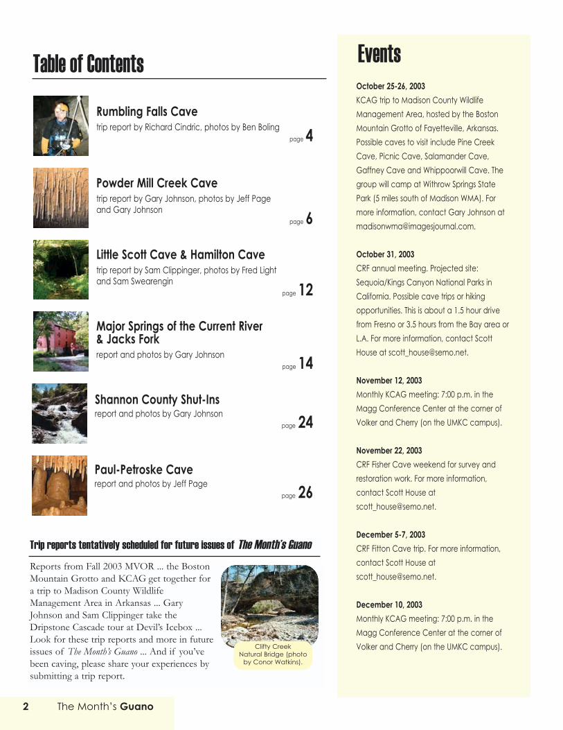
October 25-26, 2003 KCAG trip to Madison County WildlifeManagement Area, hosted by the BostonMountain Grotto of Fayetteville, Arkansas.Possible caves to visit include Pine CreekCave, Picnic Cave, Salamander Cave,Gaffney Cave and Whippoorwill Cave. Thegroup will camp at Withrow Springs StatePark (5 miles south of Madison WMA). Formore information, contact Gary Johnson [email protected].
October 31, 2003 CRF annual meeting. Projected site:Sequoia/Kings Canyon National Parks inCalifornia. Possible cave trips or hikingopportunities. This is about a 1.5 hour drivefrom Fresno or 3.5 hours from the Bay area orL.A. For more information, contact ScottHouse at [email protected].
November 12, 2003 Monthly KCAG meeting: 7:00 p.m. in theMagg Conference Center at the corner ofVolker and Cherry (on the UMKC campus).
November 22, 2003 CRF Fisher Cave weekend for survey andrestoration work. For more information,contact Scott House [email protected].
December 5-7, 2003 CRF Fitton Cave trip. For more information,contact Scott House [email protected].
December 10, 2003 Monthly KCAG meeting: 7:00 p.m. in theMagg Conference Center at the corner ofVolker and Cherry (on the UMKC campus).
EventsTable of ContentsRumbling Falls Cavetrip report by Richard Cindric, photos by Ben Boling
page 4
Powder Mill Creek Cavetrip report by Gary Johnson, photos by Jeff Pageand Gary Johnson
page 6
Little Scott Cave & Hamilton Cavetrip report by Sam Clippinger, photos by Fred Lightand Sam Swearengin
page 12
Major Springs of the Current River & Jacks Forkreport and photos by Gary Johnson
page 14
Shannon County Shut-Insreport and photos by Gary Johnson
page 24
Paul-Petroske Cavereport and photos by Jeff Page
page 26
Trip reports tentatively scheduled for future issues of The Month�s GuanoReports from Fall 2003 MVOR ... the BostonMountain Grotto and KCAG get together fora trip to Madison County WildlifeManagement Area in Arkansas ... GaryJohnson and Sam Clippinger take theDripstone Cascade tour at Devil�s Icebox ...Look for these trip reports and more in futureissues of The Month�s Guano ... And if you�vebeen caving, please share your experiences bysubmitting a trip report.
Clifty CreekNatural Bridge (photo
by Conor Watkins).

The Month�s Guano 3
The Month�s GuanoOctober 2003, Vol. 17, Issue 9-10
The Month's Guano is published bi-monthly
Submit articles via e-mail to the editor: [email protected]. Preferred file format fortrip report attachments: Microsoft Word. Multiplephotos are typically required for each trip report.
Guano subscription rate for nonmembers: $6.00annually. Electronic: FREE.
President: Jeff Page([email protected])V.P./Treasurer: Richard CindricSecretary: Jeff Andrews ([email protected])Web Master: Sam Clippinger ([email protected])
Editor: Gary Johnson ([email protected])Co-editor: Bryon Carmoney ([email protected])Copy editors: Bill Gee & Pam Rader
The Kansas City Area Grotto is affiliated with theNational Speleological Society and the MissouriSpeleological Survey. In addition, KCAG is aFounding Member of Missouri Caves & KarstConservancy.
Meetings are held every second Wednesday at 7 p.m. at Magg Hall (behind SpencerLaboratories) on the UMKC campus, Volker Blvd.& Cherry, Kansas City, Missouri.
Annual Dues: $15 for Full Members (three cavingtrips with KCAG, nomination, and vote ofmembership required.)
NCRC Callout number � Emergency use only:Central Region (502) 564-7815. This number maybe used for cave rescue emergencies in thestates of Illinois, Indiana, Iowa, Kentucky,Michigan, Missouri, Ohio, and Wisconsin.
This October's issue appears at first blush to be a hodge-podge of
cave articles ranging from Tennessee to Meramec State Park and
the Scenic Riverways in Missouri. But
there is a common theme to be
found. All of the subjects have
some preservation efforts in their
history. Whether it be the political
will to set aside land for a National
Park or an alliance of activists to
halt a development effort, it is true
that we would have fewer caves,
rivers, and other natural resources to
enjoy without the willingness of people to
get involved and work for the benefit of future generations. As we enjoy
the articles in this issue, let's remember that the places we love most
can never be taken for granted.
Cave softly and safely,
Jeff PageKCAG President
MessagePresident
A From
the
Draperies in a PowderMill Creek Cave watercrawl
(photo by Jeff Page).
Cover photo
The spring branch at Alley Spring runs through this verdant area. Therocks are covered in moss. Tiny snails cling to everything. Spring wateralso passes through a chute beside the mill. This water joins the springbranch on the far side of the trees in the upper right side of the photo. Atrail bridge is visible in the distance. Photo by Gary Johnson.

The Month�s Guano4
Ijust got back from another drive hard,cave hard, drive hard trip. The objec-tive was Rumbling Falls Cave in
eastern Tennessee. This cave was discov-ered relatively recently and has some noto-riety because of its huge volume. Itsdiscovery played havoc with the construc-tion of a sewage treatment plant. A photoof the very large �Rumble Room� wasfeatured on the front cover of the NSSNews, and Sports Illustrated published anarticle about the cave's discovery andexploration.
Ben Boling, Jerry Cindric and JimWatson invited me on the trip. They hadvisited the cave once before, a little over ayear ago. It had rained hard just beforethey went in then, so I got to hear count-less horror stories about the water.
The entrance is very near a highway.The walk was 100 yards (at most) downhill.It was steep, though not Alexander Cavesteep! The entrance is positivelyspacious�maybe 12' wide and 2' to 3' tall.I was a little incredulous that a cave solarge and emitting so much air hadn�t beenfound until recently,, but I guess the semi-steep terrain had something to do withthat.
We went in about 20' and came to an80' deep slot. It�s possible to stay on topand skirt the edge for a bit, but we didn�tdo that. The way forward was down andthat�s where we went. The originalexplorers were nice enough to leave somebolts and hangers for us, so we didn�t haveto mess around with a nasty anchor.
The width of the drop starts out about4' and widens to about 12' at the base.The stream that was the nemesis a year agowas now a trickle, which was good becauseit�s right at the bottom of the slot. Bentook some photos, I took some photos,and Jim shot video.
The plan was simple: go upstream.The downstream route would likely go to aresurgence in the creek below the entrance,though I don�t know that. It was a cleanwalking passage up to the first waterfall,which might have been 20' tall. Someonewas nice enough to leave a rope for usaway from the falls, but it was easy to freeclimb through the small water flow so wedid that. The next, similar waterfall was ashort distance away. It didn�t seem safe to
A trip to
RumblingFalls Cavein Tennessee
A trip to
RumblingFalls Cavein Tennessee
trip report by Richard Cindrictrip report by Richard Cindricphotos by Ben Bolingphotos by Ben Boling
Above: Richard Cindric in Rumbling Falls Cave(photo by Ben Boling).

The Month�s Guano 5
free climb, so we either used another pre-existing rope or climbed up a chimney.
The passage continued on as before,but the floor and ceiling gradually gotnearer until we had to hands-and-kneescrawl for a few hundred feet. The rockswere small and the water was minimal: Itwas as pleasant as stream crawling can be.
When we were able to stand up, wecrawled under a natural bridge and soongot into some canyon passage. It wasn�tfun or pretty. I think Jim did the mostcussing, but we all had our moments. Thecanyon is roughly 20' tall. We started outwalking sideways, switched to crawling,went up a level and walked on a ledge, wentup to the top and crawled there, went downto the mid-level ledge, then back down tothe floor, I think. It�s like Nike says: you�just do it.�
At the end of the canyon is � WHOA� the Rumble Room! We left the narrowsof the canyon and were immediately on theedge of a huge void. 4+ acres. Man, talkabout echo! I thought about the originalexplorers and pray I can make a discoverylike that some day.
We had gone to some trouble to lugJerry�s new 300' rope to this point, so wedecided it was time to rig it and see if PMIdid a good job in making it. They did.Good.
I went first. I didn�t enjoy the 200'rappel like I should have because I was toobusy watching the rope to make sure Ididn�t rappel into a knot. I had the ropepack tethered to me, so the rope was payingout as I went down. There�s nothing wrongwith that except, as I said, I couldn�t fullyenjoy the experience.
My main memory of it was the black-ness. The drop was near the center of theroom rather than against a wall. The wallswere too far away to be seen and the airwas misty, so my only view was the ropereceding into darkness. Too cool.
We didn�t do too much after reachingthe bottom, although there is a boat load ofhuge passages beyond. Ben used his newdigital camera to take group photos. We
didn�t know which way the cave continued,so we spent some time searching. Wefinally found the water passage, which wethink is the way to go, but we decided tojust take photos of it rather than immerseourselves in it. I was Ben�s flash slave.
The stream was about 20' wide andflowing very slowly. It was murky so wecouldn�t see the bottom, but 6'+ deepwouldn�t surprise me. The bank was sandyand continued into the water. We couldmake out some large boulders in there aswell. Ben and I hummed the theme songto Jaws.
The Rumble Room is tall as well aswide. I guesstimated the top of the break-down was 100' to 150' above the stream, soadd that to the 200' drop to envision it. It�salso unstable as hell. I don�t think I�ve everhad so many rocks slip out from under meor teeter when I stepped on them.
Jerry and Jim were near the top of thebreakdown while Ben and I were at thestream. When we rejoined them, theyasked us if we were hurt by the rockcollapse. They said there was a massiveBOOM followed by more concussions.Ben and I didn�t hear a thing. Like I said,there�s a lot of unstable breakdown and Ican easily believe we made it more unstableby walking over it, although we were fortu-nate to not be present when gravity had itsway.
Something that surprised me about theRumble Room were the critters. We sawbig crickets, spiders, and flying insects,although we might have been half a milefrom the entrance. There was some vegeta-tion along the murky stream, so I wonder ifthose nutrients accounted for the animallife. We saw very few bats, so their guanocouldn�t be the cause.
The trip out was uneventful. Jim tookan hour of video (with his usual, interestingnarrative) so we watched that on Jerry�sVCR on the 11 hour drive home.
Top: Jerry Cindric, Richard Cindric, and JimWatson prepare to go caving. Middle: JimWatson prepares to descend as Jerry Cindricwatches. Bottom: Jerry Cindric in a RumblingFalls waterfall (photos by Ben Boling).

A trip to PowderMillCreekCave
A trip to PowderMillCreekCavetrip report bytrip report byGary JohnsonGary Johnsonphotos byphotos byJeff Page &Jeff Page &Gary JohnsonGary Johnson
Much of the land near the Current River is honey-combed with caves. Most of these caves are rela-tively short, but there are a few lengthy cave
systems mixed in with the simple single passage caves thatserve as the norm. Powder Mill Creek Cave is the longestknown cave system in the Current River Valley. With overseven miles of mapped passages, Powder Mill Creek Cave isan impressive cave with a large entrance passage and a nicewide creek that runs wall to wall for nearly a half mile backinto the cave. Unlike Devil�s Icebox�another cave with awatery entrance passage�you don�t need a canoe to enterPowder Mill Creek Cave. While there are places that reachwaist deep, most of the journey consists of sloshing throughknee-deep water. Occasionally you get to step onto clay orsand banks. And eventually the creek begins taking some alter-nate paths that leave the main branch dry. This entrancepassageway is large, twenty to thirty feet high (occasionallyreaching as high as 40), and varying from 40 to 80 feet wide.The first three quarters of a mile is easy passage. Then you
Above: The entrance to Powder Mill Creek Cave (photo by Gary Johnson).Left: This large formation is dubbed �The Dinosaur� (photo by Jeff Page).

reach the first of the cave�s five major watercrawls. Some ofthese watercrawls go on for thousands of feet, requiringcavers to don wetsuits and even float on their backs to nego-tiate low air space sections. So after the easy entrancepassageway, this becomes a very demanding cave that willpush even the most experienced cavers to their limits.
I got an opportunity to see part of Powder Mill CreekCave when Hal Baker asked for volunteers to accompanyhim on a geology trip. I had heard about those watercrawls,though, and didn�t want any part of them. So when Haloffered a little trip that would only venture about 1,500 feetinto the cave, I thought that�s for me and signed up. But tomy disappointment (I had already traveled all the way toEminence), this trip was cancelled. However, later, Hal toldme about another trip he had scheduled, and this trip wouldallow me to see more of the cave. On the down side, itwould mean negotiating two watercrawls. He said the firsttwo watercrawls weren�t bad and didn�t require a wetsuit�just polypros. I didn�t exactly jump at the opportunity to jointhis trip. I�ve got a touch of claustrophobia and tight crawlsaren�t exactly easy for me, but Hal said the first two water-crawls mostly involve hands and knees crawling. We�d only bebelly crawling for short distances. Okay, I can do that. So Isigned up. Jeff Page had already signed up for this same trip,so we decided to travel together in his new SUV and campon Hal�s property. Hal has a great spread on the South Forkof the Jacks Fork River. His property includes a couple smallcaves, a spring, and lots of nice places for setting up a tent.
As Jeff and I passed Springfield and headed east onHighway 60, storm clouds swirled overhead. A weatherreport on the radio predicted hail�up to softball size. Butthe clouds seemed to part and either head north towardSalem or south toward West Plains. And while we did indeedget rained on that evening, it was only a short shower. Later,we learned this same storm had left tens of thousands ofhomes back in Springfield without electricity. So I guess wewere lucky. I was concerned the rain might have brought upthe water level in the cave, but Hal said rain didn�t have muchof an effect the first two watercrawls. These watercrawls areseparated from the creek that occupies the entrance passageby a three-foot-high waterfall. So while the creek level mightclimb during rainfall, the waterfall provided some protectionfrom rising water. Some of the cave�s other watercrawls,however, aren�t advisable during rain. In fact, Doug Baker�ssurveying trips are automatically cancelled by rain.
Top: Soda straws and helectites in the main passage of Powder Mill CreekCave. Bottom: This thick column rises about 20 feet (photos by Jeff Page).
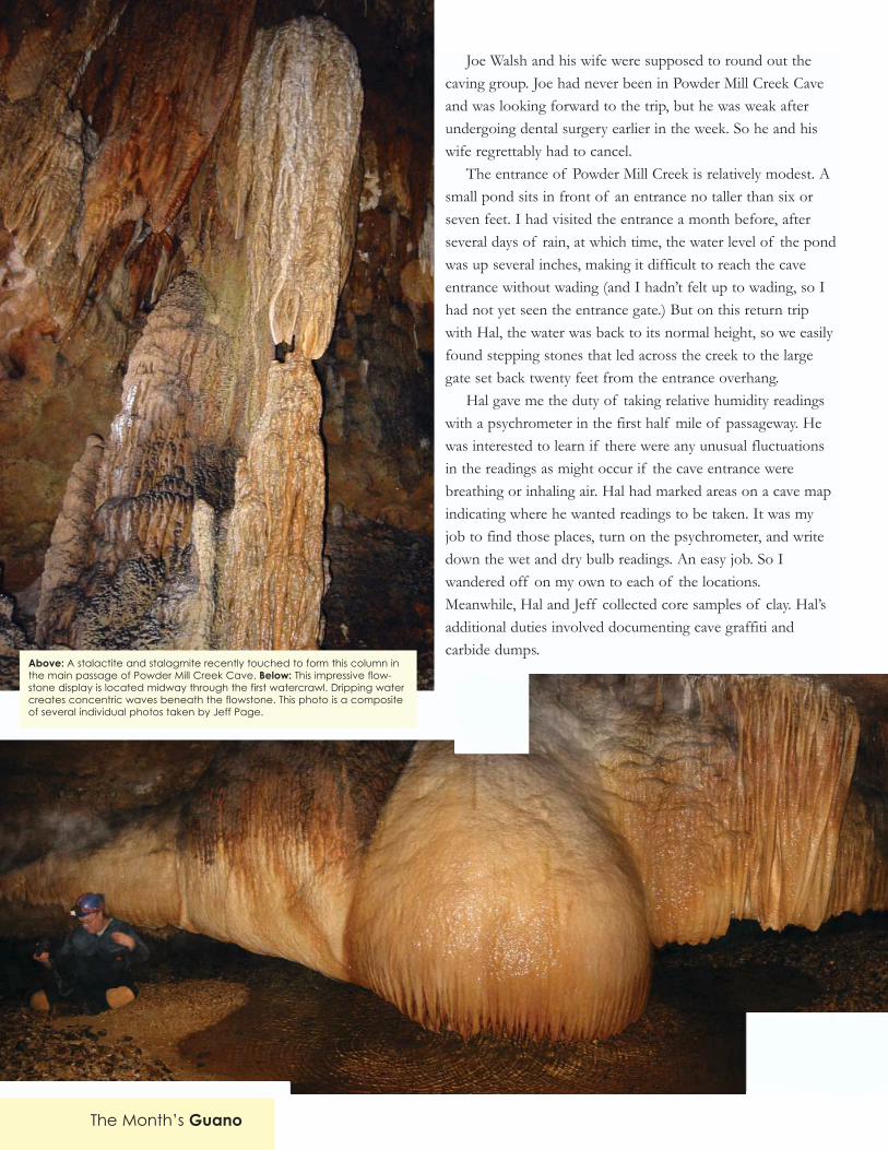
Joe Walsh and his wife were supposed to round out thecaving group. Joe had never been in Powder Mill Creek Caveand was looking forward to the trip, but he was weak afterundergoing dental surgery earlier in the week. So he and hiswife regrettably had to cancel.
The entrance of Powder Mill Creek is relatively modest. Asmall pond sits in front of an entrance no taller than six orseven feet. I had visited the entrance a month before, afterseveral days of rain, at which time, the water level of the pondwas up several inches, making it difficult to reach the caveentrance without wading (and I hadn�t felt up to wading, so Ihad not yet seen the entrance gate.) But on this return tripwith Hal, the water was back to its normal height, so we easilyfound stepping stones that led across the creek to the largegate set back twenty feet from the entrance overhang.
Hal gave me the duty of taking relative humidity readingswith a psychrometer in the first half mile of passageway. Hewas interested to learn if there were any unusual fluctuationsin the readings as might occur if the cave entrance werebreathing or inhaling air. Hal had marked areas on a cave mapindicating where he wanted readings to be taken. It was myjob to find those places, turn on the psychrometer, and writedown the wet and dry bulb readings. An easy job. So Iwandered off on my own to each of the locations.Meanwhile, Hal and Jeff collected core samples of clay. Hal�sadditional duties involved documenting cave graffiti andcarbide dumps.
The Month�s Guano
Above: A stalactite and stalagmite recently touched to form this column inthe main passage of Powder Mill Creek Cave. Below: This impressive flow-stone display is located midway through the first watercrawl. Dripping watercreates concentric waves beneath the flowstone. This photo is a compositeof several individual photos taken by Jeff Page.

Alongside the main passage, we saw several nests of grassand weeds. Hal said these were beaver nests. Here the passagewas large and wide and the water in the center of the channelwas two to three feet deep. So there was plenty of water toattract beavers. They weren�t attempting to build a dam, butthey were definitely calling the cave home. I also saw manycrawdads throughout this section of the cave stream. Thewater was perfectly clear, until my footsteps clouded it, that is.Every time I stopped and spent more than a few secondslooking into the water, I found some crawdads. Thiscontinued for at least 300 yards into the cave. In addition, Isaw one fish�a sculpin� about a half mile back into thecave. It was about eight inches long with brown bands. Theonly mammals we saw were bats. A little beyond the half-milepoint I saw a cluster of bats on the cave ceiling. The clusterwas about a foot in diameter, maybe a little larger. Hal quicklyidentified the bats as grey bats and speculated that a colony ofthis size, which easily might contain a hundred or more bats,could possibly close the cave. But in general we did notencounter many bats. We found a few grotto salamanders andcave crickets, but that was about the extent of the cave fauna.However, this cave has proven rich for fossils. Hal pointed outtwo clay beds where digging had revealed bones of severalnow-extinct creatures. In addition, Hal pointed out a snakeskeleton. This 18-inch-long snake skeleton was well back intothe cave, beyond the first watercrawl.
Eventually breakdown chokes off the main passage;however, the constant flow of water has continued to work itsway through the cave, finding other avenues. To continuefurther back into the cave, it becomes necessary to follow thestream course through the first watercrawl. It�s about 300 feet
The Month�s Guano 9
Top: Fluted draperies line the ceiling in this section of the secondwatercrawl. This photo is a composite of several photos taken by JeffPage. Bottom: Formations are plentiful in �The Cloisters� area ofPowder Mill Creek Cave (photo by Jeff Page).

The Month�s Guano10
long and through that entire route you�re in several inches ofwater. Thankfully, it�s mostly hands and knees crawling with noreal belly crawls of more than a few feet. I found there wasoften room to walk stooped over, usually with my hands on theclay bank as I sloshed sideways like a crab through the stream.If you take this strategy you must be very careful because thereare occasional soda straws and stalactites. After this first water-crawl, the passageway soon opens up again with a high ceilingand a large trunk passage. The Bone Passage cuts through atthis point. This is a large passage, with a ceiling height ofnearly 50 feet. The left side section is much larger than theright section. The left side section continues for three or fourhundred feet before the passage is choked off by clay and dirt.This passage features some sections where the clay floor hasbeen sculpted by dripping water, resulting in small towers thatresemble mini-city landscapes. This section of the cave alsoincludes some beautiful crystals on the cave floor. As Hal tookpictures of the crystals, Jeff and I followed the passage to itsterminus. We climbed to the top of a steep slope to make surethe passage terminated and found a small crawlway that mighthave continued further, but we didn�t pursue this route. (Becareful walking in the Bone Passage or you might stumble overthe tiny clay towers.)
The right side section of the Bone Passage is one of thehighlights of the cave. Hal gave us directions where to go andhe then stayed behind while Jeff and I climbed a narrowvertical passage into an upper level. We continued forward for100 feet to an incredible display of tall rimstone dams. Theseries of dams was probably 15 feet high or more. Lookingfrom above at the dams, we saw large basins of crystal clearwater. These basins overflowed and dripped into lower basins.Drops of water splashing in the basins sent out volleys ofconcentric waves. Above the rimstone dams, the cave wall wascovered with flowstone and soda straws. Some of these sodastraws were exceptionally long, possibly measuring as much asfive or six feet. Regrettably, by the time we reached this passage(we actually explored this passage on our way back out of thecave), Jeff �s camera batteries were low and his storage cardswere full, so we have no photos of the rimstone dams or theimpressive soda straws hanging above the dams.
The second watercrawl was arguably tougher than the first.It contained little water, just a few puddles, but this was bellycrawl territory and it wore down my stamina. Sharp chert linedthe floor of the passage. Hard plastic kneepads would be agood idea. Foolishly, I had assumed this would be a muddycave (not sure why I made that assumption), so I had packed a
Top to bottom: Formations such as these line the walls and ceiling of�The Cloisters� in Powder Mill Creek Cave (photo by Jeff Page).

The Month�s Guano 11
pair of knee/shin pads made for playing softball (andintended to prevent burns from sliding). They would�veworked well in mud. But the pads weren�t thick enough forchert, so I felt the sharp edges on my knees. I was very glad toget through this watercrawl so I could stand up again.
Immediately past the second watercrawl, we entered anarea filled with thick columns named �The Cloisters.� Thisarea contains the highest concentration of formations thatI�ve seen in any wild cave in the Ozarks. The height fromfloor to ceiling is only about eight feet in this section of thecave. But the room is chock full of wide columns, varyingfrom three to eight feet thick. Small pools had formed onsome of the formation ledges. Clusters of soda strawsdescended from snow-white splotches on the ceiling. As Halsat down and took notes regarding this chamber, Jeff used upthe last of his photos. This is a very unique and beautiful areaof the cave.
This would be the end of our journey. Just beyond thisarea, the third watercrawl begins. So we soon began to retraceour steps and begin the journey back to daylight. From thetime that we entered the cave to the time that we left the cave,over nine hours elapsed. This was the longest time that I�vebeen in a cave. But the time flew past. It�s very difficult for meto judge time when I�m in a cave. If someone had said we hadbeen in the cave for five hours, I would�ve believed them.
This is a marvelous cave, with many impressive forma-tions. Soda straws fill the ceilings in many locations, oftenmixed with thick displays of helectites (as at the beginning ofthe first watercrawl). You�ll find several large-scale formations.These are mostly clustered togeher in the main passage aboutthree quarters of a mile from the entrance. Here you�ll find awide column over 20 feet tall and a tyrannosaurus-shapedformation that some people call �The Dinosaur,� about 15feet tall. And mid way through the first watercrawl, you�ll finda magnificent example of flowstone�an orangish frozenNiagara with a bulbous mid section and thinner flows to thesides. This formation is at least 30 feet wide.
The only way to see Powder Mill Creek Cave is by partici-pating in a work trip, such as Hal Baker�s geology trips orDoug Baker�s surveying trips. The cave is not open for recre-ational caving. So if you�d like to see Powder Mill Creek Cave,look for cave trip announcements. These announcements arefrequently posted in the MOCAVES listserv group and they�refrequently published on the KCAG Web site�s �Events� page.Whatever the case, be prepared to participate.
Above: Soda straws grow from a remnant of a chert layer in the secondwatercrawl (photo by Jeff Page). Below: A small pond sits at the mouth ofPowder Mill Creek Cave (photo by Gary Johnson).

On June 21st, Gary Johnson and I, accompanied by twoscouts and two adult leaders from Troop 118, wentcaving near Meramec State Park. The saga began the
previous fall when Bryon Carmoney and I visited one of thistroop�s meetings, where we gave a short presentation and slideshow. The Scoutmaster, Fred Light, is an old friend of mine andused to be Scoutmaster of my Troop as well.
He contacted me after our presentation to begin discussingdates for a trip. Initially, Bryon planned to go and suggested somecaves and camping spots that I had never seen. After some amus-ingly confused moments of trying to decide which cave(s) to visit,followed by Bryon�s job schedule not allowing him to attend (atthe last minute, of course), the trip was nearly cancelled. It wassaved at the very last minute when I e-mailed Gary and he agreedto go.
We camped in Meramec State Park on Friday night andreviewed equipment and rules. In the morning, our first visit wasto Hamilton Cave. The park office has the key and they�ll give itto anyone who acts prepared for caving. They marked the cave�slocation on a map for us and we were off. Along the hike, we sawthe Old Hamilton Ironworks, complete with educational signsabout its history. (The ticks had seen the signs too and werewaiting for us. Hilarity ensued.)
Finally, after about 20 minutes of walking in the stream, wereached the cave. I�d never been in Hamilton before and I wasimmediately impressed by the size of its gate. The entrance isprobably 20' tall and 30' wide. The gate is set back about 50 feetfrom the cave�s dripline. The gate served as a good introductionfor the novices about the importance of conservation and whygates are necessary in the first place. We also talked briefly aboutthe lengths to which some people will go to defeat gates.Everyone was impressed with the effort (and expense) involved ininstalling this particular gate.
Most of the cave wasn�t much different than the entrance�mostly big walking passage with flowing water on the floor. Theone exception to this was a side passage near the entrance thatcontained a room with lots of water activity. Overall the roomwasn�t very large but it had a beautiful clear pool and some lily padformations. Nearby there was a large old (dry) rimstone dam, oneof the deepest I�d ever seen. It was located under a shelf, wellaway from the walking path, which is probably why it is still intact.In the rest of the cave, there were no decorations to speak of andno real physical challenges, although that didn�t stop us fromclimbing up the banks in a few places so we could crawl alongledges close to the ceiling. All in all, it was a good, easy introduc-tion to caving for three of our novices who had never beenunderground before. It allowed them all to learn that some cavesaren�t really challenging; they didn�t have anything to be nervousabout.
After exiting Hamilton Cave, we found a convenient path thatwent from the cave entrance directly to the parking lot. Tip toothers: walking the path is much easier and faster than walking inthe stream (if only we�d followed it on our way in). On the wayback we passed a group of three young men who were headed theother way. They were dressed in T-shirts, shorts and tennis shoes.One of them was carrying a headlamp and another had a largeflashlight in his pocket. They stopped when they saw us andasked �Is the cave down that way?� �Yep,� I replied. Theythanked us and resumed walking. I called after them �It�s gatedand locked though. You�re not going to be able to get in.� Theylooked disappointed. Knowing I had the only key in my pocket, I
The Month�s Guano12
trip report by Sam Clippingerphotos by Fred LIght and Sam Swearengin
A trip to
Little Scott Cave& Hamilton Cave
Top: The entrance to Hamilton Cave is surrounded by vibrant vegeta-tion. Bottom: Sam Swearengin heads out of Hamilton Cave. A hugegate protects the cave from unwanted visitors (photos by Fred Light).

The Month�s Guano 13
cheerfully explained that they had to go to the park office to get akey. I�m so helpful.
We stopped at the iron foundry for lunch (provided by theScouts) before heading for Little Scott. It was a warm day butsitting inside the remains of the huge stone furnace was nice andcool. Almost like being in a cave... except for the ticks, which weacquired by walking around the foundry and observing the oldMissouri Department of Conservation signs. We (especially Gary)spent the next 20 minutes or so flicking ticks off of our clothing.
[Editor�s note: Because Old Hamilton Ironworks is farremoved from the rest of Meramec State Park�and thus an easytarget of vandals�administrators have decided to let the foundrygrounds return to nature, under the belief that thick weeds andbugs will do a better job of protecting it than the state.]
I�ve been in Little Scott before, and so far it�s my favoritenovice cave. It�s easy enough for inexperienced cavers to movethrough, but it presents enough physical challenges to make itinteresting. The passages are complex enough that often there areseveral different ways to get through, either by chimneying,climbing, or crawling. There are several sections that are nicelydecorated but easy enough to move through that the formationsare clean. Everyone had a great time in Little Scott. When we gotto the back (thanks to the talents of Gary, who had a map), wefound ourselves faced with a 30' belly crawl that led to a 1' highwater crawl. The map indicated that there was more cave beyondthe water crawl and the two scouts wanted to continue. I couldsee that the adults were all tired (myself included) and none of usreally wanted to get soaked. We turned around and the scouts ledus out. I congratulated them on leading us out without getting lostonce, unlike my previous trip to Little Scott where an experiencedcaver led us in circles on the way out (*cough* *cough* *bryon**cough*).
Since the scouts were still excited about having �an adventure�underground, we headed back to find Hamilton Springs Cave.According to the map it�s a rather small cave, but I�d been assuredit was very muddy�just what the scouts needed. The park officehad told us �the entrance is right above the spring.� Finding the
spring was easy butthere was no entrance,only a newly collapsedpile of rock (1-2 yearsold) in a small pit,filled with eroded dirtand leaves. The mapsaid the entrance was small, and since we couldn�t find it after 45minutes of searching, we thought it might have collapsed.Everyone waded in the stream a bit to wash off, then headed backto camp. The next day, one of the park rangers told us that theentrance is actually about 300' away. The collapsed pit we foundwas an attempt to dig another entrance that had, as we saw,collapsed.
All in all, it was a great trip. Everyone in the group had a lotof fun. The scouts were very well-behaved, both above and belowground. They were interested in caves and had more questionsthan I was qualified to answer. I would definitely take this groupon another trip if they want to go.
All the photos on this page are from Little Scott Cave. Photos by FredLight, except as noted. #1: Sam Clippinger points out breakage. #2: NickLight and Lee Gibbs stand in front of a nice column (photo by SamSwearengin). #3:Nick Light prepares to drop through the entrance gate.#4: Formations line this wall cavity in Little Scott. #5: A cave salamanderat the entrance. #6: Fred Light poses between columns (photo by SamSwearengin).
1 2
3
4
5
6

report and photos byreport and photos byGary JohnsonGary Johnson
Major Springs ofthe Current
River& Jacks Fork
Major Springs ofthe Current
River& Jacks Fork
Photo: Blue Spring silenty rises at the base ofa bluff. Watercress fills the stream branch
(photo by Gary Johnson).

The Month�s Guano 15
Many rivers throughout the Ozarks have fallen victim todam projects. The Osage River is now interrupted byhuge reservoirs at Truman Lake and Lake of the
Ozarks (not to mention dams at Stockton Lake and Pomme deTerre that affect the Osage River watershed). The White River isinterrupted by three major dams, which form Beaver Lake, TableRock Lake, and Bull Shoals. The Black River was dammed to formClearwater Lake. The St. Francis River was dammed to formWappapello Lake. The Elk River was dammed in NortheastOklahoma to form Grand Lake O� The Cherokees. The NorthFork of the White River was dammed for Norfolk Lake. At times,it seemed as if the Army Corps of Engineers was intent on placingdams on virtually every river in the Ozarks. But a handful of riversin the Ozarks have escaped lake projects, such as the Buffalo Riverin Arkansas, the Gasconade (the longest river wholly containedwithin Missouri), the Eleven Point, the Meramec, and the Current.Several of these rivers were indeed targeted for dam projects butvocal opposition arose, and the dam projects were headed off.
I can hardly imagine the Ozarks without any of these streamsrunning unimpeded. But particularly I think of the marveloussprings along the Current River. These are some of the largestsprings in the world, and a lake would have likely submerged manyof these springs under several feet of lake water. Thankfully, theCurrent River dam project never happened and we can continue toexperience these marvelous locations where bluish water emergesfrom deep depths (well over 100 feet in some cases) to flow pastwatercress and tumble down boulder strewn spring branches,accompanied by steep dolomite and limestone bluffs and thickoutgrowths of ferns. These are truly special places.
The following notes provide brief descriptions of each of themajor springs along the Current River. While writing this article, Idrew heavily upon the work of Gerald Feder and Jerry Vineyard inSprings of Missouri and Jo Schaper in Missouri Speleology (Vol. 32,Issue 4).
Montauk SpringsUntil 1892, spring waters at Montauk rose at a single rise pool
at least 200 feet deep (according to Steve Kohler in Two OzarkRivers), but then a storm and flood washed a huge amount of sedi-ment, gravel, and boulders into the spring�s mouth. Now, insteadof flowing to the surface in one spring, water bubbles to thesurface in no less than 14 separate locations, generally in shallowpools. None of these springs can compare in terms of flow ordramatic location with the other major springs of the CurrentRiver, but taken together, these springs represent a significantjumpstart to the Current�s headwaters. Pigeon Creek is a relativelyaverage sized creek until the flow from Montauk Springs morethan doubles the stream size and necessitates a new name entirelyfor this body of water. This is where the Current River becomesthe Current River.
Montauk Springs are located in Montauk State Park. While
other state parks, such as Round Spring, Big Spring, and AlleySpring, were handed over to the National Park Service when OzarkNational Scenic Riverways was created in 1964, Montauk StatePark remained in the hands of the Missouri Department ofConservation. MDC operates a fish hatchery at Montauk, wherethey concentrate on raising rainbow and brown trout. As a result,most of the activities at Montauk revolve around fishing, withlarge crowds of fishermen patrolling the river and a nearby lake.However, even non-fishermen should enjoy a trip to Montauk.Children enjoy seeing the hatchery pools (we saw a ground hogwaddling beside the main hatchery pools) and a preserved millfrom the 1920s provides a sense of history. In addition, this sitehas proven popular with birdwatchers. A lodge, restaurant, store,
Top: One of the numerous rise pools at Montauk Springs. Above left: Aview from within the ruined hospital at Welch Spring. Straight ahead is asmall portal that leads into Welch Cave. Above right: This stairway risesfrom the thick vegetation that enshrouds the hospital ruins at WelchSpring. The stairs lead to the hospital�s upper floor (photos by GaryJohnson).

The Month�s Guano16
and cabins round out the scene. For cavers, however, the maininterest is the springs. To see them, though, you�ll likely have topush past fishermen who fiercely patrol the water where thesprings join the Current River. On a recent trip, we encountered alarge white-tailed doe at one of the larger spring rise pools. Shewas drinking from the water. She hesitantly made room for us sowe could get a closer look. I wish the fly fishermen had been soconsiderate. They steadfastly stood their ground along the dirt trailthat led from the trailhead parking to the various springs.
Welch SpringAt most springs, water flows to the surface from a rise pool
situated at the base of a bluff (as at Blue Spring, Pulltite, and AlleySpring). At first glance, Welch seems to fit into this same pattern,but in this case, the rise pool is actually situated in a cave. Thespring water rises in darkness within the cave and then passesthrough a large tube and under a dolomite ledge before emerginginto daylight at the base of a bluff, only a short distance (approxi-mately 100 feet from the Current River). Of course, I�mcompletely relying upon the work of Jo Schaper for this descrip-tion of the spring�s inner workings. You cannot enter the cave. It isa gated cave and entry requests are not granted, for the caveharbors Indiana bats.
Welch Spring has arguably the most interesting and uniquehistory of any of the Current River springs. For many years, the
land around the spring was owned by the Welch family (thus thename of the spring). However, in the 1920s, Dr. Christian H. Dielpurchased the land. He believed the cool pollen-free air emergingfrom the cave would be beneficial to patients suffering fromasthma, so he funded the construction of a sanatorium beside thespring. In addition, he dammed the pool at the base of the bluff,raising the water level of the spring and closing off entrance to thecave. As a result, any air escaping from the cave was forcedthrough a small entrance into the basement of the sanatorium. It�snot clear whether this entrance was an enlargement of an existingentrance or a completely new entrance. Unfortunately forDr.Diehl, his asthma therapy never caught on. After he died in anauto accident, the sanatorium was abandoned. The shell of thistwo-story stone structure remains. It�s surrounded by thick weedsand forest, like the remains of a lost Mayan temple. Its front stepsabruptly climb out of the weeds. The building was much smallerthan I expected. There couldn�t have been room for more than twoor three patients at any one time. The entire upper floor couldn�thave been more than 15 feet by 20 feet. The window into the caveis in the lower level. At first I didn�t see a gate and thought maybeit had been breached, but then I shined my light into the darkwindow, I found the gate about 15 feet beyond�with a large flowof spring water moving immediately behind it. According to DonRimbach who mapped the cave in the �70s, the cave is about 2,000feet long and contains several unique formations, but once again,according to Jo Schaper, entry requests are not granted.Nonetheless, this is still a fascinating location.
Above: Welch Spring rises within a cave and then flows under this bluff. Onthe far side of the spring branch, hospital ruins are buried in thick vegetation(notice the rectangular window opening) (photo by Gary Johnson).

The Month�s Guano 17
You can get to Welch Spring either by canoe or hiking. Toreach it by canoe, you would have to be prepared to float fromBaptist or Cedargrove. To reach Welch Spring on foot, you havetwo choices. First, you can hike in from the downstream side byway of Welch Landing (head north from Akers on Hwy. K andfollow the signs). After arriving at Welch Landing, hike a half mileupstream along an easy, level trail. When I hiked this trail, I saw amink, a watersnake, and a brown snake. The trail was somewhatovergrown and could be a real problem in summer months whenticks are out in force. The problem with this first route to WelchSpring, however, is it puts you on the opposite side of the springbranch from the hospital. So if you approach from this direction,you can only view the hospital ruins from a hundred feet away.(Wading across the spring branch is strictly forbidden.) The secondhiking option requires a more strenuous hike. Return to Hwy. Kand head north from the Welch Landing turnoff to the first leftturn. This is a service road. Park your car in the pullout and thenhike down the road as it descends to the river. Bear right at thefirst fork or you�ll end up in a shooting range on the bluff abovethe spring. The road is somewhat steep, but the hike is relativelyeasy. This road leads directly to the hospital.
At the nearby Akers, a ferry still operates for carrying cars andpassengers across the Current River. The National Park Serviceused to operate a campground at Akers, but the campground isnow closed and used as a parking area for the floaters.
Pulltite SpringWhile most of the major springs along the Current are acces-
sible by car and short hikes, Pulltite requires a little more work. It�snear the Pulltite campground, but it�s across the river. So ideally, ifyou plan to visit Pulltite Spring, you�ll be floating down the river ina canoe on your way to Round Spring. To reach Pulltite Spring onfoot, head for the Pulltite showerhouse and then continue downthe road until you see an old service road on the right. Follow thisroad as it heads for the river. When the trail emerges at the river,look across the river and to the right. You�ll be looking at thePulltite Spring branch as it enters the Current River. I recommendheading upstream about 50 yards before you attempt to cross. Thatway you won�t be fighting both the Current River and the PulltiteSpring branch. At normal flow at this crossing, the river will beabout mid thigh deep, which can be high enough to knock you offyour feet if you aren�t careful, so don�t take this crossing lightly.Once across, you�ll find a trail on the left side of the spring branch.(Do any wading that�s necessary in the Current�not in the springbranch.) This is an especially scenic location as the spring flowsthrough a beautiful little hollow. Everything seems to be green.You�ll see lots of watercress as the water rushes down the boulder-strewn stream. The stream is virtually alive with vegetation. Thebluff on the left shows clear signs of past cave activity, withseveral small, much-weathered formations remaining in cavities in
Above: Pulltite Spring flows through a beautiful, verdant hollow. Below: The Pulltite Spring rise pool (photos by Gary Johnson).

The Month�s Guano18
the bluff. Soon the bluff disappears and an old cabin appears. Thislog cabin was built in the French style, with logs placed verticallyinstead of the more frequently encountered horizontal placements.The National Park Service has attempted to stabilize the structure,but frequent visitation has left the structure marred with manycarved names. The masonry chimney has attracted many scribblesand high school graduation dates. Further up the hollow, PulltiteSpring emerges from the base of a bluff. The water is blue andclear. A tall bluff rises behind the spring. This bluff may very wellcontain some cave passages, which would have been carved whenthe water table was higher. But with large patches of poison ivyserving as a deterrent, I didn�t take the time to investigate thebluff. Over the past 100 plus years, several mills were built alongthe Pulltite Spring branch, but most traces of these mills have longsince been obliterated.
The name �Pulltite� is a shortened form of �pull tight��which describes the action a wagon driver must take whendescending the steep road into the hollow (as in, he must �pulltight� on the reins). Not far downstream from where the PulltiteSpring branch empties into the Current, you�ll find another spring:Fire Hydrant Spring. This spring is likely connected to PulltiteSpring. It gushes from the base of a bluff, only two or three feetabove the Current River.
The Pulltite campground is located immediately east of theCurrent River. Many of the campsites have their own little pathsthrough the brush down to the river. Part of the process ofpicking a good campsite at Pulltite is finding one with a good pathto the river. The campsites are a little too close together for mytaste, with few trees separating the sites, so don�t expect muchprivacy here. In addition, the showers are located way down by the
Above: Watercress covers the floor of the Pulltite Spring branch. Below: A stairway winds down to the viewing platform at Devil�s Well(photos by Gary Johnson).

The Month�s Guano 19
group campsites, so they�re a long walk for most people. At groupcampsite 3, you�ll find a nice hiking trail that follows the river andthen loops around a hill, passing by a small cave (McDonald Cave)with a sinkhole entrance.
Devil�s Well and Cave SpringDevil�s Well is Missouri�s most well known window into a
spring system. Now part of Ozark National Scenic Riverways,Devil�s Well can be reached by a dirt road that heads south fromHwy. KK. Devil�s Well is a classic example of karst topology. Anopening at the bottom of a sink provides a free fall drop of 100feet to a lake below. This lake is about 250 feet long and 100 feetwide. A depth of 70 feet was determined by Jerry Vineyard backin the �60s. Dye placed in this lake has appeared within a week atCave Spring, two miles to the south on the Current River. Back inthe �50s, Devil�s Well was a commercial attraction. For a fee, youcould sit on a bosun�s chair that would be lowered into the fissureby way of an electric winch. At this time in the well�s history, avisitor center was built over the sink. Once the National ParkService took control of the property, the visitor center wasremoved and a stairway was built to the bottom of the sink. Ametal platform now leads up to the fissure, with a metal cagepreventing anyone from falling in. If you lean forward into themetal cage, you can see down into the fissure. By pressing a switch,you can also turn on a light that hangs far below and illuminatesthe walls of the fissure and the greenish spring water. You can�t seemuch. The angle of vision is severely restricted, but this is still anexceptionally impressive site. Back in the �50s and �60s, JerryVineyard led trips into Devil�s Well. Canoes were lowered on ropesand cavers explored the handful of short muddy passages thatcould be entered from the lake. Today, the site is very low key, withonly modest facilities�a single picnic table and grill and a smallrestroom with pit toilets. A surface pond sits to the east.
One of my intentions during this trip was to float the CurrentRiver and paddle into Cave Spring, which is located along theCurrent River (between Pulltite and Round Spring). However,thunderstorms forced us to float a different section of the riverinstead. So Cave Spring will have to wait for another year. The risepool emerges in the back of Cave Spring Cave. The spring tubedrops straight down for 150 feet. A horizontal tube then continuesover 200 feet to the east to connect Cave Spring with a pool visiblethrough a floor crack in Wallace Well Cave. This conduit has beenexplored by divers. A similar conduit system may connect Devil�sWell with Wallace Well., although to the best of my knowledge, noone has dived the entire distance.
Round SpringAll of the major springs along the Current River are different
in significant ways. Round Spring is notable for its large, round risebasin (about 100 feet across)�which gives the spring its name.
The basin was no doubt at one time part of a cave, but the ceilingcollapsed. The spring rises in this basin, where vertical walls rise 20to 30 feet on all sides, and then flows under the south wall, toemerge as the spring branch. As a result of this unusual arrange-ment, the spring seems to emerge twice�on the far side of therise basin and at the base of a small bluff in the spring branch.During times of heavy rains, the water level in the basin rises untilit floods over the top of the south wall. During normal flow, therise pool is completely silent. The basin seems to be a still pool.But beneath the surface, water flows at a surprisingly large volumethrough the cavity in the south wall. During extremely dry periodswhen the water level drops, the top of this cavity reportedlybecomes visible. The spring branch is filled with watercress andsnails. It rolls leisurely beside a picnic area and a campgroundbefore joining the Current River.
According to Indian legend, the spring came into being when awarrior rapped his fight stick on the ground and left the hole thatis now the rise basin. Divers have descended the basin and
Above: Round Spring flows beneath this small bluff and continues tothe right (photo by Gary Johnson).

predictably discovered breakdown. This breakdown blocks accessto the feeder channel.
The Round Spring campground is one of my favorites of thelarge campgrounds in Ozark National Scenic Riverways. It�s largebut many of the sites are nonetheless fairly isolated. Trees andbrush separate the sites on the perimeter, allowing some semblanceof privacy. A nice river access area is within walking distance ofthe campsites. A cluster campsite is available for the floaters whodon�t mind camping clustered together in a relatively small area.And the cluster sites have their own river access. In addition, awalkway leads across the Current River to the camp store and thegroup campsites. Canoe rental facilities are also available at thestore. For the more leisurely inclined, you can rent an inner tubeand then float all the way to the main campground�s river access,about a half mile total distance.
A road leads under Hwy. 19 to the parking lot for RoundSpring Caverns. This cave is one of the largest ones in the area,with large rooms and plenty of headroom throughout most of thesouth passage, which is where the tours go. The tours emphasizethis section of the cave because it is much more decorated thanthe north passage. The �tobacco barn� is arguably the tour�s high-light. This room is decorated with many draperies that hang like �well, leaves in a tobacco barn. Most of the draperies are reddishbrown but a few streaks of white are also apparent. A small streamruns beside most of the tour passageways. The tour guide pointedout the dangers of thinking spring water is good for drinking. Indramatic fashion, he trained his flashlight on the stream, whichseemed clean enough, but then he gradually raised the beam toreveal an area that the stream had just flowed past�a large pile ofbat guano. We didn�t see many bats in the cave, and all the ones wedid see were Eastern Pippistrelles. Most of the cave life that wesaw was encountered in the entrance passage. This is a side passagethat was enlarged by past owners of the cave, in pre-National Parkdays when Round Spring Caverns was operated as a commercialcave. In this entrance passage, we encountered a cluster of fivecave salamanders. The past owners seem to have taken fairly goodcare of the cave. They never installed sidewalks or handrails orlights. The cave was left in a relatively natural state. Now, tours areconducted with hand held lanterns. The lights don�t cast a greatdeal of light, so I had to spend most of my energies on simplywatching my feet�instead of watching the cave. I wish thelanterns were a little brighter. The guide was experienced and intel-ligent. He wasn�t exactly a cave expert or a geology expert, but hehad nonetheless acquired a good understanding of the cave. The
Above: Formations from Round Spring Caverns. The rightside photoshows a typical drapery from the �The Tobacco Barn.� Below: The BlueSpring rise pool is impossibly blue (photos by Gary Johnson).

tour operations are relatively low key. A simplestorage shed serves as the tour headquarters. Youbuy your ticket here and then the guide leads youon a short hike of no more than a quarter milethrough the woods, across a creek, and up a smallincline to the cave�s modest entrance, which isshrouded in trees and shadows. Interestingly, thebridge across the creek is hinged so that duringfloods it swings to the far side. A chain can thenbe pulled on the near bank to pull the bridge backin place.
Blue SpringThis might be my favorite of the Current River
springs. It doesn�t attract hordes of visitors, likeBig Spring. Its remote location discourages manyvisitors, so visits to Blue Spring are laid back. I�vebeen there twice and both times I encountered fewother visitors, three the first time and only twoduring the second visit. But Blue Spring isn�tnotable just because it attracts few visitors. It�snotable because of the spring�s depth and theclear, blue water. You can lean out from theviewing platform and stare deep into the spring.This is what I think of when I think of springs inFlorida�beautiful clear water with a hint of blueand boulders enveloped in light coatings of vegeta-tion. The spring�s feeder channel drops away (justout of view) for nearly 200 feet. This is thedeepest of the Current River�s springs. The
Above: Two views of Big Spring. This spring rises in a series of waves thatrush out into the huge spring branch. The bottom photo is a compositephoto formed from multiple individual photos (photos by GaryJohnson).

The Month�s Guano22
extreme spring depth no doubt adds to the water�s blueness. Buteven without staring into the spring�s depths, the water in the risepool seems a vibrant blue. The spring branch flows for a half milebefore meeting the Current River. The branch is similar to thePulltite Spring branch, but not quite as verdant.
You can reach Blue Spring on foot by two routes. From thePowder Mill campground, a trail strikes out along the CurrentRiver. Another shorter route joins this same trail from nearer BlueSpring. This means driving down the dirt-and-gravel access roadfor Blue Spring. This road can be a bit steep and rocky, but it wasin good shape on both of my visits. Some sources recommend afour-wheel drive vehicle, but I haven�t encountered any troubles onthis road in a two-wheel-drive vehicle. The Blue Spring facilitiesinclude a small picnic area and vault toilets. A short trail leadstoward the Current and joins the trail from Powder Mill for thefinal half mile. The Current River is wide and deep at this point. Ifyou�re concerned about the Blue Spring access road and don�tmind a two-mile hike, then head for Powder Mill instead.
A visitor center was built at Powder Mill by the National ParkService back in the �70s, complete with an operating blacksmithshop for demonstrations during the summer months. But lack ofvisitors spelled doom for the visitor center. It�s now no longeropen to the public. A small campground is nestled next to the
river. A ferry service used to operate here. Across the river, youcan still see the concrete remains of the dock�s foundation.
Big SpringMost of the Missouri springs rise to the surface silently, but the
biggest spring in the state rises in a rush of water. The springbranch looks like a medium size river, over 100 feet across. This isa genuinely awe-inspiring spring. It�s not only the largest in thestate; it�s one of the largest springs in the world. For a graphicexample of the cave building capacity of springs, Jerry Vineyardreported in Springs of Missouri that O.R. Grawe had calculated themineral content of the spring water and determined the corre-sponding volume of cave passage that would be represented: hereported that each year rock amounting to a passage 30 feet high,50 feet wide, and one mile long was being removed. Consideringthe thousands of years that Big Spring has flowed that adds up toa mind-boggling amount of cave. Divers have plumbed the depthsof Big Spring, but they could not penetrate far because breakdownchokes the passageway, although divers have reported glimpses ofhuge chambers beyond the breakdown.
Today, Big Spring is one of the most frequently visited springsin the state. Located only a short drive from Hwy. 60, a steadystream of visitors find their way to Big Spring. A wide paved path
Above: Water from Alley Spring rushes through a channel beside thephotogenic Alley Mill (photo by Gary Johnson).

The Month�s Guano 23
leads from the parking lot to the rise pool. A steep bluff risesbehind the rise pool. At the base of the bluff and invitingly locatedare a couple small caves. These might be the most frequentlyvisited non-commercial caves in the state. Higher up, the bluff ispockmarked with more caves. At least one of the caves connectswith the Big Spring conduit. This cave, which has a small crawlwayentrance, is gated. A dirt path follows the spring branch to thesouth and runs past several small caves in the bluff face. Most visi-tors are drawn directly to the rise pool, where water rushes fromunderneath the bluff and surges in a series of waves before joiningthe massive spring branch. The Current River is already quite wideby the time Big Spring joins the flow, but Big Spring leaves itsimprint in the color of the water. You can trace the Big Springwater. It�s clear and blue, while the rest of the Current is a lessvibrant green. Behind the parking lot, you�ll find a large picnic areawith wide fields and lots of elbowroom. The Ozark NationalScenic Riverways main headquarters is located nearby in VanBuren. From the park headquarters, a road enters Mark TwainNational Forest and provides access to a moderate-sized spring�Watercress Spring.
Alley SpringAny discussion of Current River springs wouldn�t be complete
without mention of Alley Spring. It�s located on Jack Fork River,not the Current. But Jacks Fork is the Current River�s major tribu-tary. Where the two rivers meet, with Jacks Fork still swollen fromAlley Spring�s output, the Current River grows by about a third.While Alley Spring doesn�t attract as many day visitors as BigSpring, it�s nonetheless one of the most popular sites in OzarkNational Scenic Riverways. Its campground is huge and frequentlypacked. Thankfully, the campground is located across the highwayfrom the spring, and this makes the spring seem slightly moreisolated. If you�ve only visited Alley Springs in the fall or winter,you�ll want to visit it in the summer sometime. From MemorialDay to Labor Day, Alley Spring Mill is opened, and it containsexcellent examples of antique mill machinery. Guides on hand canexplain the flour and corn mill operations, and nice exhibits on theupper floor give some background information on the region. Inaddition, an authentic schoolhouse has been setup along the trailfrom the parking lot to the mill. In conjunction with the construc-tion of the mill, the spring was dammed. Most of the spring waternow runs through a niche in the dam, passing through the turbinesthat power the mill. A walkway leads around the rise pool. Divershave followed the spring conduit down for over 150 feet. Thespring branch is especially attractive. It flows at the base of thesteep bluff in a small verdant streambed of polished rocks.Watercress and moss cling to the rocks. The bluff is pockmarkedwith dozens of small cave entrances. Another trail leads to the topof the bluff and provides wider vistas of the surrounding land.(An additional Jacks Fork spring, Blue Spring, is described in theApril 2003 issue of The Month�s Guano.)
SourcesKohler, Steve, 1984, Two Ozark Rivers: The Current River and the JacksFork, University of Missouri Press, Columbia, Missouri.
Schaper, Jo, 1992, �Large Springs of the Upper Current and JacksFork�s River Basins� in Missouri Speleology, vol. 32, number 4.
Vineyard, Jerry D., and Gerald L. Feder, 1982, Springs of Missouri,Missouri Department of Natural Resources, Rolla, Missouri.
Above: The Alley Spring rise pool (photo by Gary Johnson).

While Shannon County is mostly known forits caves, rivers, and springs, it also hostssome less common geological features
known as �shut-ins.� In these areas, resistant layersof igneous rock, frequently rhyolite porphyry, havebeen laid bare by erosion of the overlying sedimen-tary rock. While limestone and dolomite trend toerode when in contact with water, igneous rock ismore resistant to erosion. Streams that pass overthese outcroppings of rhyolite take much longer towear a path through the rock, and as a result, thestream water tends to get trapped in small pools.These pools are called shut-ins.
During a recent visit to the springs of theCurrent River, I also visited several sites notable fortheir shut-ins: Rocky Falls, Klepzig Mill, and PrairieHollow Gorge.
Rocky FallsRocky Falls is the most well known of the
Shannon County shut-ins. It�s located on OzarkNational Scenic Riverways lands, along Rocky Creek,southeast of Eminence, off County Road NN. Signson the nearby roads point the way to the site, so itreceives a considerable number of visitors, most ofwhom come to take a dip in the swimming hole atthe base of the falls. During the summer, it�sfrequently hard to find a time when visitors aren�tscrambling across the falls and leaping into the poolbelow.
Rocky Falls drops about 40 feet altogether. Mostof this drop is a diagonal slide down the imperviousrock face of pink and purple porphyry. Watercollects in occasional pools and slides to lower levels.
It�s easy to climb to the top of the falls; however,
Shannon County
Shut-Insreport and photos by Gary Johnson
Above left: At Rocky Falls, the creek slides down this face of rhyoliteporphyry. Left: At Kelpzig Mill, the creek slows as it encountersigneous rock (photos by Gary Johnson).

The Month�s Guano 25
all climbers should be especiallycareful because the hard igneous rockis very unforgiving.
Camping isn�t allowed at RockyFalls, but you�ll find a picnic table andpit toilets.
Klepzig MillDownstream from Rocky Falls,
Rocky Creek continues to the northfor several miles on its route to theCurrent River. Along the way it runsthrough several shut-ins. One ofthese areas can be reached at KlepzigMill, north of Mill Mountain, three orfour miles northeast of Rocky Falls.The dirt access road runs throughsome soft sandy soil, so a vehicle withhigh clearance is probably recom-mended, although I�ve made the tripin a two-wheel drive passenger car.
Klepzig Mill isn�t particularlyphotogenic, unlike the mill at AlleySpring. It�s a sawmill house, made ofsimple vertical planks and a corru-gated iron roof. If you step inside themill, you�ll find a few remnants of themill machinery and an open pit wherea turbine would have rotated. A verysimple operation.
Just outside, Rocky Creekcontinues its journey to the CurrentRiver. You�ll find clumsily constructedconcrete footings for a water chute.The creek spills over pink and purpleporphyry, much like the rock at RockyFalls, only on a smaller scale. Thevertical drop here is only a few feet,maybe ten to fifteen feet altogether.The water pools are a bit too shallowto serve as swimming holes, but it�sfun to jump from rock to rock as youinspect the small waterfalls and shut-ins. Crawfish love the pools here. Ifyou spend a few seconds inspectingthe pools, you�ll almost certainly findseveral crawfish scuttling along thebottom.
There are no facilities here, just acouple unmarked places for vehiclesto park. The Ozark Trail passes
through this area. And not far to thenorthwest, you�ll find a primitivecamping area that is typically chokedwith tall weeds.
Reportedly, the ruins of theKlepzig family home and barn arelocated nearby, but I�ve not seenthem. Recently, the mill structure wasstabilized with new materials. Carewas taken to use weathered planksthat would help the structure retain itsprimitive charm.
Prairie Hollow GorgeI almost missed finding Prairie
Hollow Gorge. It�s located just southof the Two Rivers access point, onthe east side of County Road V, downa road that is clearly marked as aprivate road. However, the first partof the road, which leads to PrairieHollow Gorge, is on public land.You�ll need to park your vehicle at thetop, where there is room for three orfour vehicles, and then walk down thesteep hill. When you reach a concreteslab at the bottom of the hill, you�vereached Prairie Hollow. An intermit-tent stream flows over the concrete,and nearby you�ll find some verymodest examples of shut-ins. To findthe gorge, however, you�ll need tolook for a path heading south alongthe west side of the stream. Not morethan 50 yards up this path, you�llbegin hearing some modest waterfallsto your left. Continue up the path,past numerous pine trees, and you�llsoon be forced to start squeezing pastboulders and jumping from rock torock. You�re now in a small gorgegouged through a thick layer ofigneous rock. The sides of the gorgerise a sheer 100 feet on both sides.The stream spills over numeroussmall drops. This is an absolutelybeautiful area. Rock climbing isn�tallowed in Prairie Hollow Gorge.Neither is camping, although the softpine needle beds are definitely attractive.
Above: The shut-ins near Klepzig Mill. Below: Theshut-ins at Prairie Hollow Gorge (photos by GaryJohnson).

The Month�s Guano26
Iattended the Spring MSS meeting inMeramec State Park as the KCAGrepresentative in May of 2003. This
was an unusually active session wherepresentations were given before the busi-ness meeting on various cave subjects.After the business meeting ended, somecavers from PEG asked if I�d like to jointhem on some cave trips they�d arranged.I was glad to accept.
There are many caves in Meramecavailable to the public. Some requirepermits, others are open access. Thecave on the agenda this Saturday wasPaul-Petroske, a permit cave. MichaelCarter of OHG showed us the way to it.He is active on many cave projects in thepark and had been in P-P several times.He calls it the least visited cave in thepark. One look at the entrance tells thestory. We�d been warned it was a bit ofa squeeze getting in. The entrance isabout one foot high by one and a halffeet wide. The worst part was, after abody length in, a tight constriction listedon the map as 0.7 feet. It�s probably abit bigger than that because I�m notgoing to get through smaller than 0.8�.After emptying my lungs and pushingpast the constriction, I joined StevePotter and Brent Gerling in a roomythree-foot-tall chamber.
The total mapped passage of Paul-Petroske is 2700 feet, about half a mile.That shouldn�t present too big of a chal-lenge, except that most of it is a hands-and-knees or elbows-and-knees crawlthrough water. We continued north intothe cave until it made a bend to the west.We found a dry spot to rest for a fewminutes before proceeding to a fork atabout 850 feet. We�d been told the most
scenic part of the cave was to the left (orwest). It was also the shorter of the twopassages, being about 650 feet asopposed to 1200 for the right passage.Because we had a camera, we decided togo for the pretty stuff. This passage wasa bit taller than the first, allowing somestoop walking for part of the way.When we made it to the end, we couldstand up in seven-foot-tall passage thatwas highly decorated with thousands oflong soda straws, draperies, and severalstalactiflats.
Past this area, the passage divergedinto two low, wide rooms that had manynice decorations. I pulled out thecamera and began to capturethe rewards of the long watercrawl. I got about thirty shots,including the soda straws onthe way out. The cave didn�toffer anything new or unusualin decorations, but it was niceto see them in such goodshape in a state park cave.The tight entrance and longwater crawl makes it unneces-sary to gate this cave. Wewere ready to get some dinnerby now, so we opted not toenter the long north passageon this trip. The water crawlseemed longer on the way out.
I had been under theimpression that the cave hadbeen named for one guynamed Paul Petroski. When Igot home and looked up themap, I found it was twopromising young cavers fromthe former SLUG who died intheir early twenties. On themap is written:
�This map is dedicated to Joe Pauland Jim Petroske � principalexplorers and surveyors of thiscave, officers of our grotto, andour dear friends � who were trag-ically killed in an automobile acci-dent. Their contribution to cavingand enrichment of our lives willnot be forgotten. In fond remem-brance, St. Louis UniversityGrotto.� [1981]
A trip to
Paul-Petroske Cavereport and photos by Jeff Page
Above: Formations line this passage in Paul-Petroske Cave. Below: Soda straws and stalactiflatscover the ceiling of this passage in Paul-PetroskeCave. Far Below: The entrance to Paul-PetroskeCave is a tight squeeze (photos by Jeff Page).