Embed Size (px)
Citation preview

ORDINANCE NUMBER:________________ EFFECTIVE DATE:_____________________
Prepared to comply with the
Montana Subdivision and Platting Act
CUSTER COUNTY
SUBDIVISION
REGULATIONS
TABLE OF CONTENTS
INTRODUCTION ....................................................................................................................................... 1
DEFINITIONS ............................................................................................................................................. 2
I GENERAL PROVISIONS ...................................................................................................... 10
I-A Title ................................................................................................................................................ 10
I-B. Authority .................................................................................................................................. 10
I-C. Purpose ..................................................................................................................................... 10
I-D. Jurisdiction ............................................................................................................................... 11
I-E. Severability .............................................................................................................................. 11
II GENERAL PROCEDURES ................................................................................................... 12
II-A. Preliminary Plats ...................................................................................................................... 12
II-A-1. Construction Timing .................................................................................................... 12
II-A-2. Transfers of Title ......................................................................................................... 12
II-A-3. Permission to Enter ..................................................................................................... 12
II-A-4. Pre-application Process ............................................................................................... 13
II-A-5. Subdivision Application and Preliminary Plat Submittal ............................................ 15
II-A-6. Review Process ........................................................................................................... 16
II-B. Final Plats …………………………………………………………………………………….17
II-B-1. Final Plat Contents ...................................................................................................... 17
II-B-2. Final Plat Initial Review .............................................................................................. 18
II-B-3. Restrictive Covenants – Approval, Content and Enforcement by Governing Body .... 19
II-B-4. Public Improvements Agreement; Guaranty ............................................................... 20
II-B-5. Amending Approved Preliminary Plats Before Final Plat Approval .......................... 20
II-B-6. Final Plat Approval ..................................................................................................... 21
II-B-7. Final Plat Filing ........................................................................................................... 22
II-B-8. Amending Filed Plats .................................................................................................. 22
III REVIEW AND APPROVAL PROCEDURES FOR MINOR SUBDIVISIONS ................ 23
III-A. First Minor Subdivision Review .............................................................................................. 23
III-A-1. First Minor Subdivision Application and Preliminary Plat Submittal ......................... 23
III-A-2. First Minor Subdivision Exceptions ............................................................................ 23
III-A-3. First Minor Subdivision Review Process .................................................................... 23
III-A-4. First Minor Planning Board Consideration and Recommendation .............................. 24
III-A-5. Subdivider's Preference for Mitigation ......................................................................... 25
III-A-6. Minor Subdivision Governing Body Decision and Documentation .............................. 25
III-A-7. First Minor Subdivisions – Amended Applications ...................................................... 34
III-A-8. First Minor Subdivision Final Plat ............................................................................... 35
III-B. Subsequent Minor Subdivisions ............................................................................................... 35
III-C. Expedited Review of a First Minor Subdivision ...................................................................... 36
IV REVIEW AND APPROVAL PROCEDURES FOR MAJOR SUBDIVISIONS ................ 38
IV-A. Review and Approval Procedures for Major Subdivisions ..................................................... 38
IV-A-1. Subdivision Application and Preliminary Plat Submittal .............................................. 38
IV-A-2. Time Period for Approval, Conditional Approval, or Denial ....................................... 38
IV-A-3. Public Hearing – Notice and Procedures ...................................................................... 39
IV-A-4. Planning Board Hearing, Consideration and Recommendation .................................... 39
IV-A-5. Subdivider’s Preference for Mitigation......................................................................... 41
IV-A-6. Subsequent Public Hearing ........................................................................................... 41
IV-A-7. Governing Body Decision and Documentation ............................................................ 43
IV-A-8. Amended Applications ................................................................................................. 53
IV-B. Major Final Plats .................................................................................................................... 54
V DIVISIONS OF LAND EXEMPT FROM SUBDIVISION REVIEW ................................ 56
V-A. Purpose .................................................................................................................................. 56
V-B. General Criteria to Determine Whether a Proposal is an Attempt to Evade the MSPA ......... 56
V-C. Divisions of Land Exempt from the Requirements of These Regulations and the Montana
Subdivision and Platting Act [76-3-201, MCA] .................................................................... 56
V-D. Divisions of Land Which May be Exempt from Review and Surveying ............................... 58
V-E. Divisions of Land Exempt from Review but Subject to Survey Requirements and Zoning
Regulations ............................................................................................................................. 59
V-E-1. Relocation of Common Boundary [76-3-207(1)(a), MCA] ............................................ 60
V-E-2. A Gift or Sale to a Member of the Immediate Family [76-3-207(1)(b), MCA] ............ 60
V-E-3. Divisions of Land Proposed for Agricultural Use Only [76-3-207(1)(c), MCA] .......... 61
V-E-4. Relocation of Common Boundaries Involving Platted Subdivisions [76-3-207 (1)(d), (e)
and (2)(a), MCA] .......................................................................................................... 63
V‐E‐5. Aggregation of Lots or Parcels [76‐3‐207(1)(f), MCA] ............................................... 63
V‐F Procedures and Review of Subdivision Exemptions.............................................................. 64
V-F-1. Submittal ...................................................................................................................... 64
V-F-2. Review.......................................................................................................................... 64
V-F-3. Appeals ......................................................................................................................... 65
V-G. Remaining Parcels of Land .................................................................................................... 65
V-H. Identification Codes ............................................................................................................... 66
VI. DESIGN AND IMPROVEMENT STANDARDS .................................................................... 67
VI-A. Conformance with Regulations .............................................................................................. 67
VI-B. Natural Environment .............................................................................................................. 67

VI-C. Lands Unsuitable for Subdivision .......................................................................................... 67
VI-D. Floodplain Provisions ............................................................................................................. 67
VI-E. Improvement Design .............................................................................................................. 68
VI-F. Lots ........................................................................................................................................ 68
VI-G. Blocks .................................................................................................................................... 68
VI-H. Streets and Roads ................................................................................................................... 69
VI-I. Drainage Facilities.................................................................................................................. 76
VI-J. Water Supply Systems .......................................................................................................... 77
VI-K. Sewage Treatment Systems .................................................................................................... 77
VI-L. Solid Waste ............................................................................................................................ 78
VI-M. Utilities ................................................................................................................................... 78
VI-N. Water Course and Irrigation Easements ................................................................................. 79
VI-O. Disposition of Water Rights ....................................................................................................... 80
VI-P. Park Land Dedication – Cash in Lieu – Waivers -- Administration ....................................... 80
VI-Q. Fire Protection ............................................................................................................................. 82
VI-R. Special Requirements for Subdivisions Proposed in Areas of High Fire Hazard ................... 83
VI-S. Noxious Weeds ...................................................................................................................... 84
VII. AREAS THAT WILL PROVIDE MULTIPLE SPACES FOR RECREATIONAL CAMPING
VEHICLES OR MOBILE HOMES ....................................................................................... 85
VII-A. Definition ............................................................................................................................... 85
VII-B. Subdivisions That Will Provide Multiple Spaces for Recreational Camping Vehicles or
Mobile/Manufactured Homes................................................................................................. 85
VII-C. Procedures for Review ........................................................................................................... 85
VII-C-1. Review and Approval ................................................................................................... 85
VII-C-2. Improvements ............................................................................................................... 86
VII-C-3. Final Plat Review ......................................................................................................... 86
VII-C-4. DPHHS License ............................................................................................................ 86
VII-D. Design Standards for Subdivision Spaces Created by Rent or Lease ..................................... 86
VII-D-1. Design Standards .......................................................................................................... 86
VII-D-2. Additional Provisions ................................................................................................... 86
VII-E. Mobile/Manufactured Home Park Standards ........................................................................... 87
VII-E-1. Mobile/Manufactured Home Spaces ............................................................................ 87
VII-E-2. Streets ........................................................................................................................... 88
VII-E-3. Electrical Systems ........................................................................................................ 88
VII-E-4. Gas Systems ................................................................................................................. 88
VII-F. Recreational Vehicle Park Standards ....................................................................................... 88
VII-F-1. Recreational Vehicle Spaces ......................................................................................... 88

VII-F-2. Density ......................................................................................................................... 89
VIII. PLANNED UNIT DEVELOPMENTS .................................................................................. 90
VIII-A. Purpose..................................................................................................................................... 85
VIII-B. Procedures ................................................................................................................................ 85
VIII-C. Standards .................................................................................................................................. 85
VIII-C-1. Design Standards .......................................................................................................... 85
VIII-C-2. Streets ........................................................................................................................... 85
VIII-C-3. Open Space ................................................................................................................. 85
IX. CONDOMINIUMS ................................................................................................................. 87
IX-A. Procedures ................................................................................................................................ 87
IX-A-1. Review Where Land Will Not Be Divided .................................................................. 87
IX-A-2. Condominium Subdivisions Involving Land Divisions ............................................... 87
IX-B. Standards .................................................................................................................................. 87
IX-B-1. Design Standards .......................................................................................................... 87
IX-B-2. Unit Ownership Act ..................................................................................................... 87
X. CLUSTER DEVELOPMENT ................................................................................................ 88
X-A. Cluster Development Standards ............................................................................................... 88
XI. ADMINISTRATIVE PROVISIONS ..................................................................................... 90
XI-A. Fee Schedule ............................................................................................................................ 90
XI-B. Variances ................................................................................................................................. 90
XI-B-1. Variances Authorized ................................................................................................... 90
XI-B-2. Variances from Floodway Provisions Not Authorized ................................................ 90
XI-B-3. Procedure...................................................................................................................... 90
XI-B-4. Conditions .................................................................................................................... 90
XI-B-5. Statement of Facts ........................................................................................................ 91
XI-C. Amendment of Regulations ..................................................................................................... 91
XI-D. Administration ......................................................................................................................... 91
XI-D-1. Enforcement .................................................................................................................. 91
XI-D-2. Violation and Penalties .................................................................................................... 96
XI-D-3. Appeals ............................................................................................................................ 96
APPENDIX A
A. Uniform Standards for Monumentation, Certificates of Survey,
and Final Subdivision Plats
App.A-1
ADMINISTRATIVE MATERIALS
A. Subdivision Application and Materials A- 1
Part I General Description and Information A- 1
Part II Preliminary Plat Form, Contents and Supplements A- 4
Part III Environmental Assessment A-12
Part IV Summary of Probable Impacts A-14
Part V Community Impact Report A-17
B. Final Plat Approval Form B- 1
C. Sample Certificates C- 1
D. Subdivision Improvements Agreement; Guaranty D- 1
E. F.
Grant of Access Easement Exemption Review Application and Materials
E- 1 F- 1
APPENDIX B
A. Custer County Subdivision Fees G-1

i
INTRODUCTION
This page intentionally left blank.

1
2
DEFINITIONS
Whenever the following words or phrases appear in these regulations, they shall have the
meaning assigned to them by this section. When not inconsistent with the context, words used in
the present tense include the future; the singular, unless otherwise specifically defined in a
particular section, includes the plural, and the plural the singular; the word “shall” is always
mandatory, and the word “may” indicates use of discretion in making decisions.
1. ACCESS (LEGAL AND PHYSICAL):
a. Legal access means that each lot in a subdivision either abuts a public (city, county,
state, or federal) street or road, or that the subdivider has obtained adequate and
appropriate easements across all necessary properties, from a public road to each lot in
the subdivision, whether or not a road has been constructed on that property, and has
dedicated the easement or a private road for public use.
b. Physical access means that the street or road conforming to the subdivision design
standards provides vehicular access from a public street or road to each lot in the
subdivision, either from a public street or road, from a road constructed to local road
standards in the obtained easements which is dedicated to public use, or from a private
road improved to local road standards which has been dedicated to public use.
2. ADJOINING LANDOWNER (ADJACENT PROPERTY OWNER): The owner of
record of a parcel of land that is contiguous, at any point, or land that is separated from
the parcel by a road, watercourse or deeded right-of-way.
3. AGRICULTURE: All aspects of farming or ranching including the cultivation or tilling
of soil; dairying; the production, cultivation, growing, harvesting of agricultural or
horticultural commodities; raising of livestock, bees, fur-bearing animals or poultry; and
any practices including, forestry or lumbering operations, including preparation for
market or delivery to storage, to market, or to carriers for transportation to market.
4. AGRICULTURAL WATER USER FACILITIES: Those facilities which provide water
for irrigation or stock watering to agricultural lands for the production of agricultural
products. These facilities include, but are not limited to, ditches, head gates, pipes,
and other water conveying facilities.
5. BLOCK: A group of lots, tracts or parcels within well-defined and fixed boundaries.
6. CERTIFICATE OF SURVEY: A drawing of a field survey prepared by a
professional land surveyor for the purpose of disclosing facts pertaining to boundary
locations.
7. CLUSTER DEVELOPMENT: A subdivision with lots clustered in a group of five or
more lots that is designed to concentrate building sites on smaller lots while allowing
other lands to remain undeveloped. [76-3-103(2), MCA]. (If the county has county-wide
zoning or has the sophistication to review cluster developments, cluster developments are
an option that should remain in the regulations; otherwise removing this option may be
optimal.)
3
8 COMPREHENSIVE PLAN, MASTER PLAN, OR GROWTH POLICY: means a
comprehensive development plan, master plan, or comprehensive plan that was
adopted pursuant to Title 76, Chapter 1, MCA, before October 1, 1999, or a policy
that was adopted pursuant to Title 76, Chapter 1, MCA, on or after October 1, 1999.
9. CONDOMINIUM: A form of individual ownership with unrestricted right of disposal of
one or more units in a multiple unit project, with the land and other parts of the project
held in common ownership or use with owners of the other units, pursuant to Title 70,
Chapter 23, MCA.
10. COVENANT (RESTRICTIVE COVENANT): A limitation contained in a deed or
other document that restricts or regulates the use of the real property.
11. DEDICATION: The deliberate appropriation of land by an owner for any general and
public use, reserving to the landowner no rights that are incompatible with the full
exercise and enjoyment of the public use to which the property has been devoted. [76-3-
103(3), MCA].
12. DEQ: The Montana Department of Environmental Quality.
13. DIVISION OF LAND: The segregation of one or more parcels of land from a larger tract
held in single or undivided ownership by transferring or contracting to transfer title to or
possession of a portion of the tract or properly filing a certificate of survey or
subdivision plat establishing the identity of the segregated parcels pursuant to the
MSPA. The conveyance of a tract of record or an entire parcel of land that was created
by a previous division of land is not a division of land. [76-3-103(4), MCA].
14. DWELLING UNIT: Any structure or portion thereof providing complete, independent
and permanent living facilities for one household.
15. EASEMENT: Authorization by a property owner for another to use, or restriction on the
right of the owner to use, all or a portion of the owner’s property for a specified purpose.
16. ENGINEER (PROFESSIONAL ENGINEER): A person licensed in conformance with
the Montana Engineers' and Land Surveyors' Act (Title 37, Chapter 67, MCA) to
practice engineering in the State of Montana.
17. FIRST MINOR SUBDIVISION: A proposed minor subdivision from a tract of record
that has not been subdivided or created by a subdivision under the MSPA or has not
resulted from a tract of record that has had more than five parcels created from that tract
of record under 76-3-201 or 76-3-207, MCA, since July 1, 1973. [76-3-609(2), MCA].
18. FLOOD: The water of any watercourse or drainage which is above the bank or
outside the channel and banks of such watercourse or drainage [76-5-103 (8), MCA].
19. FLOOD OF 100 YEAR FREQUENCY: A flood magnitude which has a one percent
chance of occurring in any given year , or is a flood magnitude which is expected to
recur on the average of once every 100 years [76-5-103 (9), MCA].
4
20. FLOODPLAIN: The area adjoining the watercourse or drainage that would be covered
by the floodwater of a flood of 100 year frequency [76-5-103 (10), MCA].
21. FLOODWAY: The channel of a watercourse or drainage and those portions of the
floodplain adjoining the channel that are reasonably required to carry and discharge the
floodwater of any watercourse or drainage [76-5-103 (11), MCA].
22. GOVERNING BODY: The governing authority of a county, city, town, or
consolidated local government organized pursuant to law [76-3-103 (7), MCA].
23. IMPROVEMENT AGREEMENT: A contractual agreement that may be required by the
governing body to ensure the construction of such improvements as required by local
subdivision regulations. The improvement agreement may require collateral to secure
the construction of such improvements, such as the deposit of certified funds,
irrevocable letters of credit, performance or property bonds, private or public escrow
agreements, or similar financial guarantees.
24. LANDOWNER: All individuals, groups, or parties with a title interest in the
property. For purposes of 76-3-207, MCA, when a parcel of land for which an
exemption from subdivision review is claimed is being conveyed under a contract-
for-deed, the terms “property owner,” “landowner,” and “owner” mean the seller of the
parcel under the contract-for-deed (24.183.1104 ARM). For all other purposes of these
regulations, the terms “property owner,” “landowner,” and “owner” mean both the seller
and the purchaser under a contract for deed.
25. LOCAL SERVICES: Local services are defined as any and all services that local
governments, public or private utilities are authorized to provide for the benefit of their
citizens.
26. LOT: A parcel, plot, or other land area created by subdivision for sale, rent, or lease.
27. LOT MEASUREMENT:
a. Lot Depth -- The length of a line drawn perpendicularly to the front lot line and
extending to the rear lot line.
b. Lot Width -- The average width of the lot.
c. Lot Frontage -- The width of the front lot line.
d. Lot Area -- The area of a lot determined exclusive of street, highway, alley, road,
or other rights-of-way or access easements.
28. LOT TYPES:
a. Corner Lot: A lot located at the intersection of two streets.
b. Interior Lot: A lot with frontage on only one street.
5
c. Through or Double-Frontage Lot: A lot whose front and rear lines both abut on
streets.
d. Flag Lot: A lot of irregular shape, the bulk of which is normally situated to the
rear of other lots, having as its frontage and access a drive connecting it to a
street.
29. MAJOR SUBDIVISION: A subdivision that creates six or more lots.
30. MINOR SUBDIVISION: A subdivision that creates five or fewer lots
31. MOBILE (MANUFACTURED) HOME: A detached residential dwelling unit, which may
consist of two or more sections, fabricated at a factory and designed to be towed on its
own chassis to a building site for occupation as a dwelling with or without a
permanent foundation. The term includes, but is not limited to, “trailer homes,”
“house trailers,” and “manufactured homes”,
whether or not the unit has been constructed after July 1, 1976, in conformance with
Federal Manufactured Home Construction and Safety Standards. The term does not
include “modular” or “factory-built buildings” that are fabricated at a factory in
accordance with the Uniform Building Code Standards applicable to site-built homes,
and are transported to the site for final assembly on a permanent foundation.
32. MOBILE (MANUFACTURED) HOME SPACE: A designated portion of a parcel of
land designed for the accommodation of one mobile home and its accessory buildings or
structures for the exclusive use of the occupants.
33. MOBILE (MANUFACTURED) HOME PARK: A tract of land that provides or will
provide spaces for two or more mobile homes.
34. MOBILE (MANUFACTURED) HOME PAD: That area of a mobile home space which
has been prepared for the placement of a mobile home.
35. MONTANA DEPARTMENT OF ENVIRONMENTAL QUALITY MINIMUM
STANDARDS: Minimum standards promulgated by the Montana Department of
Environmental Quality, pursuant to Title 76, Chapter 4, Part 1, MCA.
36. MONUMENT (PERMANENT MONUMENT): Any structure of masonry, metal, or
other permanent, durable material placed in the ground, which is exclusively
identifiable as a monument to a survey point, expressly placed for surveying reference.
37. MSPA: Montana Subdivision and Platting Act, Title 76, Chapter 3, MCA.
8. NATURAL ENVIRONMENT: The natural environment is defined as the physical
conditions which exist within a given area, including land, air, water, mineral, flora,
fauna, sound, light and objects of historic and aesthetic significance.
38. OPEN SPACE: Land or water areas retained for use as active or passive recreation
areas or for resource protection in an essentially undeveloped state.
6
39. OVERALL DEVELOPMENT PLAN: The plan of a subdivision design proposed to
be subdivided in stages.
40. PLANNED UNIT DEVELOPMENT (P.U.D.): A land development project consisting
of residential clusters, industrial parks, shopping centers, or office building parks that
compose a planned mixture of land uses built in a prearranged relationship to each
other and having open space and community facilities in common ownership or use [76-
3-103 (10), MCA].
41. PLANNING BOARD: A planning board formed pursuant to Title 76, Chapter 1, MCA.
42. PLAT: A graphical representation of a subdivision showing the division of land into lots,
parcels, blocks, streets, alleys, and other divisions and dedications.
a. Preliminary Plat: A neat and scaled drawing of a proposed subdivision
showing the layout of streets, alleys, lots, blocks, and other elements of a
subdivision that furnish a basis for review by a governing body as more
specifically set forth in these regulations and the MSPA.
b. Final Plat: The final drawing of the subdivision and dedication required to be
prepared for filing for record with the county clerk and recorder containing
all elements and requirements set forth in these regulations and the MSPA.
(Title 76, Chapter 3, MCA).
c. Amended Plat: The final drawing of any change to a filed platted subdivision , or
any lots within a filed platted subdivision.
d. Vacated Plat: A plat which has been voided under the provisions of MCA 76-3-
305, 7-5- 2501, 7-5-2502, 7-14-2616 (1) and/or (2), 7-14-2617, 7-14-4114 (1)
and/or (2), and 7-14-3115.
43. PRE-APPLICATION SKETCH (OR DRAWING): A legible drawing showing
approximate boundaries, dimensions, areas, distances and other pertinent information
of a proposed subdivision, all as more particularly set forth in section II-A-4(b).
44. PRIVATE IMPROVEMENT: Private improvements are the same types of
improvements as defined under PUBLIC IMPROVEMENTS, except the structure or
facility has not been dedicated to the public or otherwise acquired by a government
entity for public use.
45. PRIVATE ROAD: A road is private if its right-of-way has neither been dedicated nor
acquired for public use. A private road may be open to use by the general public or
public access may be restricted.
9. PUBLIC HEALTH AND SAFETY: The prevailing healthful, sanitary condition of well-
being for the community at large. Conditions that relate to public health and safety
include but are not limited to: disease control and prevention; emergency services;
environmental health; flooding, fire or wildfire hazards, rock falls or landslides,
unstable soils, steep slopes, and other natural hazards; high voltage lines or high
pressure gas lines; and air or vehicular traffic safety hazards.

7
46. PUBLIC IMPROVEMENT: Any structure or facility constructed to serve more than one
lot in a subdivision which is dedicated to the public or otherwise acquired by a
government entity for public use. Examples of typical public improvements include
parks, streets or roads, sidewalks, curbs, gutters, and street lighting, utilities, and systems
for water supply, sewage disposal, drainage, or fire protection.
47. PUBLIC ROAD OR STREET: A road or street is public if its right-of-way has been
dedicated or acquired for public use.
48. RECREATIONAL CAMPING VEHICLE: A vehicular type unit primarily designed as
temporary living quarters for recreational, camping, or travel use that either has its own
motor power or is mounted on or drawn by another vehicle.
49. RECREATIONAL VEHICLE PARK: A tract of land available to and principally used
by the public for camping, where persons can park recreational vehicles for
camping and sleeping purposes.
50. RECREATIONAL VEHICLE SPACE: A designated portion of a recreational vehicle
park designed for the placement of a single recreational vehicle and the exclusive use of
its occupants.
51. REVIEWING AUTHORITY: The DEQ or local Board of Health or Sanitarian as
authorized under Title 76, Chapter 4, MCA.RIGHTS-OF-WAY: A linear public way
established or dedicated for public purposes by a duly recorded plat, deed, easement,
grant, prescription, condemnation, governmental authority or by operation of law,
intended to be occupied by a street, non-motorized vehicle path, railroad, electric
transmission lines, water line, sanitary sewer line, storm sewer line, or other similar uses.
52. STATE: The State of Montana.
53. STREET TYPES: For purposes of these regulations, street types are defined as follows:
a. Alley: A public or private way reserved as a secondary means of access to the
rear or side of lots which abut on and are served by public roads.
b. Arterial: A street or road having the primary function of moving traffic with
emphasis on a high level of mobility for through movement and the secondary
function of providing access to adjacent land. Arterials generally carry
relatively large volumes of traffic. Arterials have two to four lanes of moving
traffic and should provide only limited access to abutting property.
c. Collector: A street or road having the equally important functions of moving
traffic and providing access to adjacent land. Collector streets have two moving
traffic lanes and up to two parking lanes.
d. Local Streets: A street or road having the primary function of serving abutting
properties, and the secondary function of moving traffic. Local streets have
two moving lanes of traffic, up to two parking lanes, and provide access to
abutting properties.
8
e. Half-Street: A portion of the width of a street, usually located along the
perimeter of a subdivision, the remaining portion of which street must be located
on adjacent property if the street is to be fully constructed.
f. Cul-de-sac: A street having only one outlet for vehicular traffic and terminating in
a turn- around area.
g. Loop: A local street which begins and ends on the same street, generally used
for access to properties.
h. Frontage Access (Service Road): A local or collector street, usually parallel and
adjacent to an arterial or major collector, which provides access to abutting
properties and controls traffic access to arterials or collectors.
54. SUBDIVIDER: Any person, firm or corporation, or other entity which causes land to be
subdivided or which proposes a subdivision of land [76-3-103(15), MCA]. When used
in these regulations, the term "subdivider" may also include the property purchaser on a
contract for deed or its agent, or the landowner's agent, if the landowner has provided the
subdivision administrator written notification that the landowner's agent is authorized to
act on the landowner's behalf and to receive notices regarding local government
decisions concerning the subdivision.
55. “Subdivision” means a division of land or land so divided that it creates one or more parcels
containing less than 160 acres that cannot be described as a one-quarter aliquot part of a
United States government section, exclusive of public roadways, in order that the title to or
possession of the parcels may be sold or otherwise transferred and includes any
resubdivision and a condominium. The term also means and area, regardless of size, that
provides or will provide multiple spaces for rent or lease on which recreational camping
vehicles or mobile homes will be placed.
56. SUBDIVISION ADMINISTRATOR: The person or persons authorized by the
governing body to perform the duties of review and administration set forth in these
regulations.
57. SUBSEQUENT MINOR SUBDIVISION: Any subdivision of five or fewer parcels that
is not a first minor subdivision.
58. SURVEYOR (PROFESSIONAL LAND SURVEYOR): A person licensed in
conformance with the Montana Engineers' and Land Surveyors' Act (Title 37, Chapter
67, MCA) to practice surveying in the State of Montana.
59. SURVEYOR (EXAMINING LAND SURVEYOR): A professional land surveyor duly
appointed by the governing body to review surveys and plats submitted for filing.
60. SWALE: A drainage channel or depression designed to direct surface water flow.
61. TITLE REPORT (ABSTRACT OF TITLE, SUBDIVISION GUARANTEE, OR
PLATTING REPORT): A report from a title service company on the condition of
title to the property proposed for subdivision, which identifies the owners of record
of the property, lien holders, encumbrances, easements and restrictions of record, and

9
all other conditions of title of public record, and accompanied by a guarantee of the
accuracy of the report from the title insurance agent or its underwriter.
62. TOPOGRAPHY: General term to include characteristics of the ground surface such as
plains, hills, mountains, slopes, and other physiographic features.
63. TOWNHOME or TOWNHOUSE means property that is owned subject to an
arrangement under which persons own their own units and hold separate title to the
land beneath their units, but under which they may jointly own the common areas and
facilities.
64. TRACT OF RECORD: An individual parcel of land, irrespective of ownership, that
can be identified by legal description, independent of any other parcel of land, using
documents on file in the records of the county clerk and recorder’s office [76-3-
103(17)(a), MCA].
65. VICINITY SKETCH: A map at a scale suitable to locate a proposed subdivision,
showing the boundary lines of all adjacent properties and streets and other information
necessary to determine the general location of the proposed subdivision.
66. WELL ISOLATION ZONE: Area within a 100‐foot radius of a water well.
67. WILDLIFE: Those animals that are not domesticated or tamed, or as may be defined in a
Growth Policy.
68. WILDLIFE HABITAT: The place or area where wildlife naturally lives or travels through.
10
I. GENERAL PROVISIONS
I-A. Title
These regulations will be known and may be cited as “The Subdivision Regulations of Custer
County;” hereinafter referred to as “these regulations.”
I-B. Authority
Authorization for these regulations is contained in the Montana Subdivision and Platting Act
(“MSPA”). [Title 76, Chapter 3, MCA.].
I-C. Purpose
The purposes of these regulations are to promote the public health, safety, and general welfare by
regulating the subdivision of land; to prevent the overcrowding of land; to lessen congestion in
the streets and highways; to provide for adequate light, air, water supply, sewage disposal, parks
and recreation areas, ingress and egress, and other public requirements; to require development in
harmony with the natural environment; to promote preservation of open space; to promote cluster
development approaches that minimize costs to local citizens and that promote effective and
efficient provision of public services; to protect the rights of property owners; and to require
uniform monumentation of land subdivisions and transferring interests in real property by
reference to a plat or certificate of survey (76-3-102, MCA).
These regulations are intended to comply with Part 5 of the MSPA, and are intended to promote:
1. The orderly development of the jurisdictional area.
2. The coordination of roads within subdivided land with other roads, both existing and
planned.
3. The dedication of land for roadways and for public utility easements.
4. The improvement of roads.
5. The provision of proper physical and legal access, including obtaining necessary
easements.
6. The provision of adequate open spaces for travel, light, air, and recreation.
7. The provision of adequate transportation, water, drainage, and sanitary facilities.
8. The avoidance or minimizing of congestion.
9. The avoidance of subdivisions which would involve unnecessary environmental
degradation.
10. The avoidance of danger or injury by reason of natural hazard or the lack of water,
drainage, access, transportation, or other public improvements.

11
11. The avoidance of excessive expenditure of public funds for the supply of public
improvements and services.
12. The manner and form of making and filing of any plat for subdivided lands.
13. The administration of these regulations by defining the powers and duties of approving
authorities, including procedures for the review and approval of all plats of subdivisions
covered by these provisions.
I-D. Jurisdiction0F
1
These regulations govern the subdivision of land within the jurisdictional area of the governing
body of Custer County.
If a proposed subdivision lies within one mile of a third class city or town or within two miles of
a second-class city or within three miles of a first class city, the county governing body must
submit the preliminary plat to the city or town governing body or its designated agent for review
and comment. If a proposed subdivision lies partly within an incorporated city or town, the
preliminary plat must be submitted to, and approved by, both the city or town and the county
governing bodies.
If a proposed subdivision is located in a rural school district, the governing body shall provide a
summary of the information contained in the subdivision application and preliminary plat to
school district trustees.
When a proposed subdivision is also proposed to be annexed to a municipality, the governing
body of the municipality will combine public hearings and otherwise coordinate the subdivision
review process and annexation procedures whenever possible.
These regulations supplement all other regulations, and where they are at variance with other
laws, regulations, ordinances, or resolutions, the more restrictive requirements apply. Other
regulations include, but are not limited to, zoning regulations, floodplain regulations, building
codes, development codes, and fire codes.
I-E. Severability
If a court of competent jurisdiction holds any word, phrase, clause, sentence, paragraph, section,
or other part of these regulations invalid, that judgment will affect only the part held invalid.
1 Comment: Jurisdiction
The city or town council of a city or town is the “governing body” for purposes of reviewing subdivisions
located within the corporate limits of the city or town. The county commission of a county is the “governing
body” for purposes of reviewing subdivisions located in unincorporated areas of the county. If a proposed
subdivision will overlap the corporate boundaries of a municipality, the subdivision must be reviewed and
approved, conditionally approved, or denied by both governing bodies [§ 76-3-601(2), MCA].

12
II. GENERAL PROCEDURES
The provisions of this section apply to Sections III, IV, VII, IX and X.
II-A. Preliminary Plats
II-A-1. Construction Timing
Construction work shall not occur on land proposed for subdivision until the governing body has
given conditional approval of the preliminary plat. Construction work undertaken prior to the
preliminary plat approval subjects the subdivider to the possibility the work will have to be
redone or removed. In addition, section 76-4-121, MCA, regulates subdivision activities.
II-A-2. Transfers of Title
Except as noted below, a final subdivision plat must be filed for record with the county clerk and
recorder before title to the subdivided land can be sold or transferred in any manner. After the
preliminary plat of a subdivision has been approved or conditionally approved, the subdivider
may enter into contracts to sell lots in the proposed subdivision if all of the following conditions
are met (76-3-303, MCA):
a. That under the terms of the contracts the purchasers of lots in the proposed subdivision
make any payments to an escrow agent, which must be a bank or savings and loan
association chartered to do business in the State of Montana;
b. That under the terms of the contracts and the escrow agreement the payments made by
purchasers of lots in the proposed subdivision may not be distributed by the escrow agent
to the subdivider until the final plat of the subdivision is filed with the county clerk and
recorder;
c. That the contracts and the escrow agreement provide that if the final plat of the proposed
subdivision is not filed with the county clerk and recorder within two years of the
preliminary plat approval, the escrow agent shall immediately refund to each purchaser
any payments made under the contract;
d. That the contracts contain the following language conspicuously set out therein: “The real
property which is the subject hereof has not been finally platted, and until a final plat
identifying the property has been filed with the county clerk and recorder, title to the
property cannot be transferred in any manner;”
e. That the county treasurer has certified that all real property taxes and special assessments
assessed and levied on the land to be divided have been paid; and
f. A copy of the contracts and escrow agreement described above must be submitted to the
planning board (or subdivision administrator). The purchase price may be blacked out.

13
II-A-3. Permission to Enter
The governing body or its designated agent(s) or affected agencies identified during the pre-
application meeting may investigate, examine, and evaluate the site of the proposed subdivision
to verify information provided by the subdivider and to subsequently monitor compliance with
any conditions if the preliminary plat is approved conditionally. The submission of a subdivision
application constitutes a grant of permission by the subdivider for the governing body, its agents,
and affected agencies to enter the subject property. This consent applies to members of the public
attending a noticed public meeting for a site visit.
II-A-4. Pre-application Process
a. Prior to submittal of a subdivision application, the subdivider shall request a pre-
application meeting with the subdivision administrator. The subdivision administrator is
the authorized agent designated by the governing body to review subdivision
applications. The meeting shall occur within 30 days after the subdivider submits a
written request for the meeting to the subdivision administrator.
b. At the time of the pre-application meeting request, the subdivider shall provide to the
subdivision administrator a sketch of the proposed subdivision showing the layout of the
proposed features in relation to existing site conditions.
i. The sketch may be a freehand sketch drawn directly on a print of a topographic
map of the area proposed for division at a scale of 1 inch to 400 feet or larger that
is adequate to show the property and must include the following:
A. Information on the current status of the site, including:
1. location;
2. approximate tract and lot boundaries of existing tracts of record;
3. description of general terrain;
4. natural features on the land, including water bodies, floodplains
geologic hazards, and soil types;
5. existing structures and improvements;
6. existing utility lines and facilities serving the area to be
subdivided;
7. existing easements and rights of way;
8. existing zoning or development regulation standards;
9. existing conservation easements;

14
10. existing covenants or deed restrictions;
11. existing noxious weeds.
B. Documentation on the current status of the site, including:
1. ownership information, such as a deed, option to buy or buy-sell
agreement, including permission to subdivide;
2. water rights, including location of Agricultural Water User
Facilities;
3. any special improvement districts; and
4. rights of first refusal for the property.
ii. Information on the proposed subdivision, including:
A. tract and proposed lot boundaries;
B. proposed public and private improvements;
C. location of utility lines and facilities;
D. easements and rights of way;
E. parks and open space and proposed conservation easements; and
F. well isolation zones.
c. At the pre-application meeting:
i. the subdivision administrator shall identify, for informational purposes, the state
laws, local regulations and growth policy provisions that may apply to the
subdivision review process including, but not limited to, zoning regulations
floodplain regulations, building codes and fire codes;
ii. the subdivision administrator shall provide the subdivider with a list of public
utilities, local, state and federal agencies, and any other entities that have an
interest in the proposed subdivision and that may be contacted for comment by
the subdivision administrator or planning board on the subdivision application.
The subdivision administrator shall also identify the timeframes that the public
utilities, agencies, and other entities are given to respond; and
iii. the subdivision administrator may identify particular additional information the
subdivision administrator anticipates will be required for review of the
subdivision application. This does not limit the ability of the subdivision
administrator to request additional information at a later time.

15
d. Unless the subdivider submits a subdivision application within 6 monthsP1F
2P of this pre-
application meeting, the subdivider must request a new pre-application meeting prior to
submitting the subdivision application.
II-A-5. Subdivision Application and Preliminary Plat Submittal
The subdivider shall submit to the governing body or to the agent or agency designated by the
governing body a subdivision application addressing these topics and containing the following
materials, all described in more detail in forms provided by the subdivision administrator, as
applicable:
1. A completed and signed Subdivision Application Form;
2. The required review fee;
3. A preliminary plat;
4. A Vicinity Sketch;
5. A topographic map;
6. A grading and drainage plan;
7. Engineering plans for all Public and Private Improvements;
8. Overall development plan if development is in phases; all phasing must be
completed within the one to three years granted for preliminary plat approval
9. Abstract of Title (or Title Report);
10. Lienholders’ acknowledgement of subdivision;
11. Documentation of legal and physical access; 12. Documentation of existing easements, including those for Agricultural Water
User Facilities;
13. Existing covenants and deed restrictions;
14. Existing water rights;
15. Existing mineral rights;
16. Names and addresses of all adjoining property owners;
17. Proposed road plans and profiles; 18. Approach/access/encroachment permits from Montana Department of
Transportation or the local jurisdiction;
19. Proposed easements;
20. Proposed disposition of water rights;
21. Proposed disposition of mineral rights;
22. *Parkland dedication calculations;
23. *Environmental assessment and/or summary of probable impacts;
24. Transportation impact analysis or transportation plan;
25. Fire risk rating analysis and fire prevention plan;
26. **Weed management plan and re-vegetation plan; 27. Property owners’ association documents, including draft articles of incorporation,
declaration and bylaws;
28. FIRM or FEMA panel map and letter identifying floodplain status;
29. Required water and sanitation information; including well isolation zones;
30. A form of Subdivision Improvements Agreement, if proposed;
31. Letter requesting a revocation of agricultural covenants;
2 This gives the subdivider six months from the date of pre-application meeting to file the application.

16
32. **Letter indicating locations of cultural or historic resources;
33. Variance request or approval;
34. Re-zoning application or approval;
35. Flood hazard evaluation; 36. Letter identifying and proposing mitigation for potential hazards or other adverse
impacts as identified in the pre-application meeting and not covered by any of the
above required materials; and
37. Such additional relevant and reasonable information as identified by the
Subdivision Administrator during the pre-application meeting that is pertinent to
the required elements of this section.
*Not required for minor subdivision applications
** Not required for minor subdivisions that qualify for expedited review in addition to items not
required for minor subdivision applications
II-A-6. Review Process
For both minor and major subdivisions, the initial review process is as follows:
a. UElement Review
i. Within 5 working days of receipt of a subdivision application and fee, date of
receipt being when the subdivision application and appropriate fee are delivered
to the reviewing agency, the subdivision administrator shall determine whether
the application contains all of the applicable materials required by section II-A-5
and shall give written notice to the subdivider of the subdivision administrator's
determination.
A. If the subdivision administrator determines that elements are missing
from the application, the subdivision administrator shall return the
application and identify those elements in the notification, and no further
action shall be taken on the application by the subdivision administrator
until the application is resubmitted.
B. The subdivider may correct the deficiencies and resubmit the application.
C. If the subdivider corrects the deficiencies and resubmits the application
the subdivision administrator shall have 5 working days to notify the
subdivider whether the resubmitted application contains all the materials
required by section II-A-5, as applicable.
D. This process shall be repeated until the subdivider submits an application
containing all the materials required by section II-A-5, or the application
is withdrawn.
b. USufficiency Review

17
i. Within 15 working days after the subdivision administrator notifies the
subdivider that the application contains all of the required elements as provided
in subsection (a) above, the subdivision administrator shall determine whether
the application and required elements contain detailed, supporting information
that is sufficient to allow for the review of the proposed subdivision under these
regulations and shall give written notification to the subdivider of the subdivision
administrator's determination.
A. If the subdivision administrator determines that the information in the
application is not sufficient to allow for review of the proposed
subdivision, the subdivision administrator shall identify specific required
information in its notification and return the application to the
subdivider, and no further action shall be taken on the application by the
subdivision administrator until the material is resubmitted.
B. The subdivider may correct the deficiencies and resubmit the
application, or withdraw the application.
C. If the subdivider corrects the deficiencies and resubmits the application
in accordance with (i)(B) above, the subdivision administrator shall have
15 working days to notify the subdivider whether the resubmitted
application and required elements contain detailed, supporting
information that is sufficient to allow for review of the proposed
subdivision under these regulations.
D. This process shall be repeated until the subdivider submits an application
that contains detailed, supporting information that is sufficient for review
of the proposed subdivision under the provisions of these regulations, or
the application is withdrawn.
ii. A determination that an application contains sufficient information for review as
provided in this subsection (b) does not ensure that the proposed subdivision will
be approved or conditionally approved by the governing body and does not limit
the ability of the subdivision administrator, planning board, or the governing
body to request additional information during the review process.
iii. A determination of sufficiency by the subdivision administrator pursuant to this
subsection does not limit the DEQ from requiring additional water and sanitation
information as part of the DEQ review of water and sanitation information.
c. UApplicable Regulations
Subdivision review and approval, conditional approval or denial shall be based on those
regulations in effect at the time a subdivision application and preliminary plat is deemed
to contain sufficient information for review. If regulations change during the element or
sufficiency review, the determination of whether the application contains the required
elements and sufficient information, and the subdivision review, shall be based on the
new regulations.

18
II-B. Final Plats
II-B-1. Final Plat Contents
The final plat submitted for approval must conform to the preliminary plat as previously reviewed
and approved by the governing body and must incorporate all required modifications and comply
with all conditions imposed at the time of subdivision application and preliminary plat approval.
The final plat and accompanying documents must comply with the Montana Uniform Standards
for Final Subdivision Plats (Appendix A). Final plats of subdivisions approved for phased
development shall be filed sequentially in accordance with the approval.
II-B-2. Final Plat Initial Review
a. UFinal Plat Submittal
The final plat approval application form (an example of which can be found in Administrative
Materials Section B), and all supplementary documents must be submitted to the subdivision
administrator at least 30 working days prior to the expiration of preliminary plat approval. The
submittal shall include, as applicable:
i. the final plat application;
ii. the final plat review fee;
iii. a statement from the project surveyor or engineer outlining how each condition
of approval has been satisfied;
iv. a Title Report or updated Abstract dated no less than 30 days prior to the date of
submittal;
v. the DEQ or local Environmental Health Department approval;
vi. the final Grading and Drainage Plan, including all road plans and profiles, state
or local encroachment permits, and the Traffic Impact Analysis (if required);
vii. all engineering plans;
viii. any homeowner association documents, including bylaws, covenants, and/or
declarations;
ix. county and/or city attorney approvals; and
x. one 11” x 17” and one 18” x 24” or larger copies of the final plat, completed in
accordance with the Uniform Standards for Final Subdivisions Plats set forth in
Appendix A.
xi. Examining Land Surveyor Report
b. UReview by Subdivision Administrator

19
i. The subdivision administrator shall review the final plat to ascertain that all
conditions and requirements for final plat approval have been me t . The
subdivision administrator will not accept, begin processing, nor schedule any
actions on a final plat submittal until a complete application and fee, and copies
of the final plat have been received. Final plat applications will not be
considered complete by the subdivision administrator until all conditions of
preliminary approval have been satisfied.
ii. If the subdivision administrator determines that the final plat differs from the
approved or conditionally approved preliminary plat, the applicant shall be
required to submit an amended application pursuant to Section II-B-5.
iii. The subdivision administrator may require that final subdivision plats be
reviewed for errors and omissions in calculation or drafting by an examining land
surveyor before recording with the Clerk and Recorder. When the survey data
shown on the plat meets the conditions pursuant to these regulations, the
examining surveyor shall certify the compliance in a printed or stamped signed
certificate on the plat.
II-B-3. Restrictive Covenants – Approval, Content and Enforcement by Governing
Body
a. The governing body may require that some or all restrictive covenants governing the use
of land within the subdivision, whether proposed by the subdivider or required by the
governing body, be set forth in a separate heading identifying them as plat approval
covenants, and indicating: “These covenant(s) may not be repealed or amended without
prior written consent of the (name of the governing body)”.
b. The governing body may require that all restrictive covenants it has required as a
condition of plat approval contain the following language: “The (name of the governing
body) is a party to this restrictive covenant and may enforce its terms”.
c. If common property is to be deeded to a property owners’ association, the covenants and
by-laws which govern the association must, at a minimum, provide for the:
i. Formation of a property owners’ association concurrently with the filing of the
final subdivision plat. Articles of Incorporation shall be filed with the Secretary
of State’s office;
ii. Mandatory membership for each property owner. Purchasers of property may
also be required to sign a waiver of right to protest the formation of a
maintenance district to maintain improvements;
iii. Perpetual reservation of the common property when required under 76-3-
621(6)(a), MCA;
iv. Payment of liability insurance premiums, local taxes, and the cost of maintaining
recreational or other facilities;
20
v. Placement of liens on the property of lot owners who are delinquent in the
payment of association fees and assessments;
vi. Adjustment of assessments to meet changing needs;
vii. Means of enforcing the covenants, and of receiving and processing complaints;
viii. Transition of control of the association from the Declarant to the homeowners.
ix. Dissolution of the association and modification of the covenants and restrictions
after obtaining the governing body’s approval of the change; and
x. Regular maintenance of roads, parks, buildings, drainage facilities, and other
facilities controlled by the association.
II-B-4. Public Improvements Agreement; Guaranty
As a condition of approval of the final plat, the subdivider must have installed all required
improvements or have entered into a subdivision improvements agreement guaranteeing the
construction, installation, and maintenance of all required improvements [76-3-507, MCA]. The
County Commissioners may require up to 100% completion of improvements related to public
health and safety, such as roads, firefighting facilities and installation of utilities, before agreeing
to the use of a subdivision improvements agreement. This requirement applies to preliminary
plats approved prior to the adoption of these regulations. If 100% completion is required,
engineering plans must be filed before approval of the final plat. A model subdivision
improvements agreement and alternative methods of guaranteeing public improvements, the
procedures and requirements for securing an agreement, and suggested conditions for
maintenance are provided in Administrative Materials D.
If the subdivider chooses to enter into a subdivision improvements agreement, guaranteeing the
public improvements through a bond or letter of credit, three bids for the cost of installation of the
public improvements shall be obtained by the subdivider. The amount of the guarantee shall be
calculated by multiplying 125% by the highest bid. As the public improvements are installed, the
subdivider shall provide a letter to the governing body indicating such, and including a copy of
the engineered plans. The county engineer or consulting engineer designated by the governing
body shall review and certify all public improvements have been installed in conformance with
the plans and specifications. Prior to the release of the guarantee, a copy of the plans, stamped by
the project surveyor or engineer in accordance with their licensing provisions, shall be filed in the
clerk and recorder’s office with reference to the final subdivision plat.
II-B-5. Amending Approved Preliminary Plats Before Final Plat Approval
a. If the subdivider proposes to change the preliminary plat after the preliminary plat
approval but before the final plat approval, the subdivider shall submit the proposed
changes to the subdivision administrator for review.
i. Within 5 working days of receiving the proposed changes, the subdivision
administrator shall determine whether the changes to the preliminary plat are
material pursuant to subsection (b) below.

21
ii. If the subdivision administrator determines the changes are material, the
subdivision administrator may require the subdivider to begin the require
payment subdivision review process again, starting with the pre-application
meeting, and of a new application fee.
iii. If the subdivision administrator determines the changes are not material, the
subdivision administrator shall accept the changes, notify the subdivider and the
governing body of that decision and the governing body shall approve of those
changes in a meeting for which notice has been given of non-material changes to
the final plat.
b. The following changes, although not an exhaustive list, may be considered material:
i. configuration or number of lots;
ii. road layout;
iii. water and/or septic proposals;
iv, configuration of park land or open spaces;
v. easement provisions;
vi. designated access;
vii. proposed covenants; or
viii. changes to conditions of approval.
c. A subdivider whose proposed changes to the preliminary plat have been deemed material
by the subdivision administrator may appeal the subdivision administrator's decision to
the governing body by written notice within 10 working days. The subdivider may
request a hearing, and may submit additional evidence to show that the changes to the
preliminary plat are not material.
d. If the subdivider and subdivision administrator determine that a condition of approval is
illegal or impossible to comply with due to circumstances outside the subdivider’s
control, economic hardship notwithstanding, the condition may be reviewed by the
governing body through a properly noticed public hearing in order to determine if the
condition may be waived or amended.
II-B-6. Final Plat Approval
a. UApproval by the Governing Body
The governing body shall examine every final subdivision plat and shall approve it if it
conforms to the conditions of preliminary plat approval and to the terms of the MSPA
and these regulations, or deny it pursuant to (ii) below.

22
i. If the final plat is approved, the governing body shall certify its approval on the
face of the final plat. When applicable, a certificate of the governing body
expressly accepting any dedicated land, easements, or improvements will be filed
with the final plat.
ii. If the final plat is denied, the governing body shall write a letter stating the
reason for denial and forward a copy to the subdivider. The governing body will
return the final plat to the subdivider within 10 working days of the action. The
subdivider may then make any necessary corrections and resubmit the final plat
for approval.
b. UInaccurate Information
The governing body may withdraw approval of a final plat if it determines that material
information by the subdivider is inaccurate.
II-B-7. Final Plat Filing
After it is approved, the final plat may not be altered in any manner except as provided in II-B-8.
The county clerk and recorder may not accept any plat for filing that does not bear the governing
body’s approval in proper form or that has been altered. The clerk and recorder may file an
approved plat only if it is accompanied by the documents specified in the Montana Uniform
Standards for Monumentation, and Final Subdivision Plats, contained in Appendix A.
II-B-8. Amending Filed Plats
a. Changes that materially alter any portion of a filed plat, its land divisions or
improvements, or that will modify the approved use of land within the subdivision, must
be made by filing an amended plat showing all alterations. Any alteration which
increases the number of lots or modifies six or more lots, or abandons or alters a public
road right-of-way or parkland dedication must be reviewed and approved by the
governing body.
b. An amended plat is subject to the procedures for reviewing major or minor subdivisions,
as appropriate. The governing body may not approve an amended final plat without the
written consent of the owners and lienholders of all lots which will be modified by the
proposed amendment.
c. The governing body may not approve an amendment that will place a lot in non-
conformance with the standards contained in Section VI of these regulations or with local
zoning regulations unless the governing body holds a public hearing on the amendment
and issues a written variance from the standards pursuant to Section XI-B, Variances.
d. The final amended plat submitted for approval must comply with the requirements for
final subdivision plats under the Uniform Standards for Filing Final Plats (Appendix A).

23
III. REVIEW AND APPROVAL PROCEDURES FOR MINOR SUBDIVISIONS
Subdivisions containing five or fewer parcels shall be reviewed as set forth in this section.
First minor subdivisions shall be reviewed pursuant to section III-A and subsequent minor
subdivisions shall be reviewed pursuant to section III-B.
III-A. First Minor Subdivision Review
The pre-application process and initial review process set forth in Section II, General Procedures,
apply to this section.
III-A-1. First Minor Subdivision Application and Preliminary Plat Submittal
a. The subdivider shall submit to the governing body or to the agent or agency designated
by the governing body a subdivision application containing the materials identified in
section II-A-5 and in the pre-application meeting, and
b. Sufficient documentary evidence from the public records demonstrating that the
subdivision will be the first minor subdivision from a tract of record;
III-A-2. First Minor Subdivision Exceptions
The following do not apply to first minor subdivisions:
a. preparation of an environmental assessment;
b. parkland dedication;
c. public hearing requirements; and
d. review of the subdivision application for the impact on agriculture, agricultural water
user facilities, local services, the natural environment, wildlife and wildlife habitat, and
public health and safety, Uif Uthe subdivision is proposed in a jurisdictional area that has
adopted zoning regulations that address those impacts.
III-A-3. First Minor Subdivision Review Process
a. UTime Period for Approval, Conditional Approval, or Denial
Within 35 working days, the governing body shall approve, conditionally approve or
deny the proposed subdivision according to Section III-A-6 of these regulations, unless
the subdivider and the subdivision administrator agree to an extension or suspension of
the review period, not to exceed one year. The review period of 35 working days begins
the day after the subdivision administrator notifies the subdivider or the subdivider’s
agent in writing that the subdivision application is sufficient for review.
24
b. UPublic Agency and Utility Review
Review and comment by public agencies or utilities may not delay the governing body’s
action on the subdivision application beyond the 35-working day review period. The
governing body will make these comments available to the subdivider and to the general
public upon request. If, during the review of the application, the subdivision
administrator or the planning board contacts a public utility, agency, or other entity that
was not included on the list provided during the pre-application meeting, the subdivision
administrator shall notify the subdivider of the contact and the timeframe for response.
III-A-4. First Minor Planning Board Consideration and Recommendation
a. URecommendation
i. UConsideration-Standards
In recommending approval, conditional approval or denial of the subdivision
application and preliminary plat, the planning board shall base its
recommendation on compliance of the subdivision application and preliminary
plat with the following:
A. these regulations, including but not limited to the standards set forth in
Section VI;
B. applicable zoning regulations;
C. The MSPA, including but not limited to 76-3-608(3), as delineated in
section III-A-6(a) and (b)(iv) of these regulations; and
D. other applicable regulations.
ii. UConsideration-Evidence
In recommending approval, conditional approval or denial of the subdivision
application and preliminary plat, the planning board may consider, without
limitation, the following (as applicable):
A. the subdivision application and preliminary plat;
B. the summary of probable impacts and proposed mitigation;
C. an officially adopted growth policyP2F
3P;
D. subdivision administrator's staff report and recommendation; and
3 The planning board may not base its recommendation solely on the subdivision application’s compliance
with an officially adopted growth policy; however it may consider the growth policy as one factor.

25
E. any additional information authorized by law.
iii. UWritten Recommendation
Within 10 working days after the public meeting, the planning board shall submit
the following, in writing, to the subdivider and the governing body:
A. recommended findings of fact based on the evidence in subsection (a)(ii)
above that discuss and consider the subdivision's compliance with and
impact on the items listed in subsection (a)(i) of these regulationsP3F
4P;
B. a recommendation for approval, conditional approval (including any
recommended conditions and/or mitigation measures), or denial of the
subdivision application and preliminary plat; and
C. a recommendation for approval or denial of any requested variances (See
Section XI-B).
b. UWater and Sanitation Information
The planning board or subdivision administrator shall collect public comment regarding
the water and sanitation information required by the MSPA and these regulations. The
planning board shall forward all comments regarding water and sanitation to the
governing body.
III-A-5. Subdivider's Preference for Mitigation
No later than two working days before the meeting at which the governing body is to consider the
subdivision application and preliminary plat, the subdivider is encouraged to submit in writing to
the subdivision administrator the subdivider's comments on and responses to the planning board's
recommendations as well as any proposed mitigation measures not already discussed with the
planning board. The governing body will consult with the subdivider and will give due weight
and consideration to the subdivider's expressed preferences regarding mitigation [76-3-608(5)(b),
MCA].
III-A-6. Minor Subdivision Governing Body Decision and Documentation
a. UPrerequisites to Approval
The governing body may not approve or conditionally approve a subdivision application
and preliminary plat unless the proposed subdivision:
i. provides easements for the location and installation of any planned utilities, both
on and off site;
4 The water and sanitation information required to be submitted is detailed in Administrative Materials “A”

26
ii. provides legal and physical access to each parcel within the subdivision and the
notation of that access on the applicable plat and any instrument transferring the
parcel;
iii. assures that all required public or private improvements will be installed before
final plat approval, or that their installation after final plat approval will be
guaranteed as provided by section II-B-4 of these regulations;
iv. assures that the requirements of 76-3-504 (1)(j), MCA, regarding the disclosure
and disposition of water rights as set forth in Section VI-O have been considered
and will be accomplished before the final plat is submitted; and
v. assures that the requirements of 76-3-504(1)(k) regarding watercourse and
irrigation easements as set forth in Section VI-N have been considered and will
be accomplished before the final plat is submitted.
b. UConsideration – Standards
In approving, conditionally approving, or denying a minor subdivision application, the
governing body shall consider subsection (a) above and whether the subdivision complies
with:
i. these regulations, including but not limited to, the design standards set forth in
Section VI;
ii. applicable zoning regulations;
iii. other applicable regulations
iv. the MSPA, including whether the proposed subdivision has been designed so that
it does not adversely impact the criteria defined below, pursuant to 76-3-608(3),
MCA, or that such adverse impacts have been avoided or mitigated to the
maximum extent possible:
A. UImpact on agriculture
Agriculture is defined as all aspects of farming or ranching including the cultivation or
tilling of soil; dairying; the production, cultivation, growing, harvesting of agricultural or
horticultural commodities; raising of livestock, bees, fur-bearing animals or poultry; and
any practices including, forestry or lumbering operations, including preparation for
market or delivery to storage, to market, or to carriers for transportation to market.
Prime agricultural lands are defined under 82-4-203 (40), MCA.
1. All subdivisions must be designed so they do not adversely
impact agriculture, pursuant to the MSPA and as identified
below, or that such adverse impacts have been avoided or
mitigated to the maximum extent possible.
27
a. Proposed subdivisions that are within a designated urban
growth area are considered to have a minimal effect on
agriculture.
b. Proposed subdivisions or associated improvements that
are located on or adjacent to prime farmland or farmland
of statewide importance as defined by the Natural
Resource Conservation Service are considered to have
an adverse impact on agriculture.
c. Proposed subdivisions or associated improvements that
predominately border land defined as agricultural or
timberland by the Montana Department of Revenue or
state trust lands are considered to have an adverse impact
on agriculture.
B. UImpact on agricultural water user facilities
Agricultural water user facilities are defined as those facilities which provide water for
irrigation or stock watering to agricultural lands for the production of agricultural
products. These facilities include, but are not limited to, ditches, head gates, pipes, and
other water conveying facilities.
1. All subdivisions must be designed so that they do not adversely
impact agricultural water user facilities, pursuant the MSPA and
as identified below, or that such adverse impacts have been
avoided or mitigated to the maximum extent possible.
a. Proposed subdivisions located on land with agricultural
water user facilities or adjoining an agricultural water
use facility are considered to have an adverse impact on
agricultural water user facilities.
b. Proposed subdivisions that involve the abandonment or
transfer of water rights from the property being
subdivided, or that involve the abandonment or removal
of agricultural water user facilities are considered to
have an adverse impact on agricultural water user
facilities.
c. Proposed subdivisions or associated improvements that
will alter access for maintenance of agricultural water
user facilities are considered to have an adverse impact
on agricultural water user facilities.
d. Proposed subdivisions or associated improvements that
will alter the movement or availability of water are
28
considered to have an adverse impact on agricultural
water user facilities.
C. UImpact on local services
Local services are defined as any and all services that local governments, public or
private utilities are authorized to provide for the benefit of their citizens including but
not limited to police, sheriff, fire, emergency, and public health services, as well as
schools, busing, and roads.
1. All subdivisions must be designed so that they do not adversely
impact local services, pursuant to the MSPA, and as identified
below, or that such adverse impacts have been avoided or
mitigated to the maximum extent possible.
a. Proposed subdivisions that are contiguous to
unincorporated town sites or within a designated urban
growth area, will use existing utilities, will have safe and
adequate access to existing road networks pursuant to
Model Subdivision Design Standards under VI-A-
20(c)(v), and will meet applicable city zoning and
building standards are considered to have a minimal
impact on local services except as otherwise provided in
subsection (F)(2)(f) .
b. Proposed subdivisions that will require the extension of
city or public sewer or water are considered to have an
adverse impact on local services.
c. Proposed subdivisions that are not contiguous to
unincorporated town sites or within a designated urban
growth area will be considered to have an adverse
impact on services including but not limited to police,
fire, and emergency services, school busing, and roads.
D. UImpact on natural environment
The natural environment is defined as the physical conditions which exist within a
given area, including land, air, water, mineral, flora, fauna, sound, light and objects
of historic and aesthetic significance.
1. All subdivisions must be designed so that they do not adversely
impact the natural environment pursuant to the MSPA and as
identified below, or that such adverse impacts have been avoided
or mitigated to the maximum extent possible.
29
a. Proposed subdivisions that are within a designated urban
growth area and will use existing utilities are considered
to have a minimal impact on the natural environment
except as otherwise provided in subsections (b) and (e)
below.
b. Proposed subdivisions or associated improvements that
are proposed in locations with riparian areas, rivers
streams, lakes, wetlands, or other natural surface waters
are considered to have an adverse impact on the natural
environment which may be mitigated by meeting or
exceeding standards pursuant to Model Subdivision
Design Standards VI-A-20(d).
c. Proposed subdivisions or associated improvements that
are proposed on land with a high water table (less than 4
feet from the surface) or designated groundwater
recharge areas are considered to have an adverse impact
on the natural environment.
d. Proposed subdivisions or associated improvements that
are proposed in locations with evidence of soils with
building or site development limitations as defined by
the soil survey, or are proposed on slopes greater than 25
percent, are considered to have an adverse impact on the
natural environment.
e. Proposed subdivisions or associated improvements that
are proposed on land with historical, cultural,
archeological, or paleontogical features are considered to
have an adverse impact on the natural environment.
E. UImpacts on wildlife
Wildlife is defined as those animals that are not domesticated or tame. Wildlife habitat
is defined as the place or area where wildlife naturally lives or travels through. (
1. All subdivisions must be designed so that they do not adversely
impact wildlife and wildlife habitat pursuant to the MSPA, and
as identified below, or that such adverse impacts have been
avoided or mitigated to the maximum extent possible.
a. Proposed subdivisions that are within a designated urban
growth area are considered to have a minimal impact on
wildlife and wildlife habitat except as otherwise
provided in subsections (c) and (e) below.

30
b. Proposed subdivisions or associated improvements that
are proposed in locations with riparian areas, wetlands,
rivers, streams, lakes, or other natural surface waters are
considered to have an adverse impact on wildlife and
wildlife habitat.
c. Proposed subdivisions or associated improvements that
are proposed in an area with rare, threatened, or
endangered species, as identified by state or federal
agencies, are considered to have an adverse impact on
wildlife.
d. Proposed subdivisions or associated improvements that
are proposed on or adjacent to land identified by state or
federal agencies as critical habitat are considered to have
an adverse impact on wildlife and wildlife habitat.
e. Proposed subdivisions or associated improvements that
are proposed in locations that would interfere with
known important or critical wildlife corridors are
considered to have an adverse impact on wildlife and
wildlife habitat.
F. UImpacts on wildlife habitat
Wildlife habitat is defined as the place or area where wildlife naturally lives or travels
through.
G. UImpacts on public health and safety
Public health and safety is defined as the prevailing healthful, sanitary condition of
well-being for the community at large. Conditions that relate to public health and safety
include but are not limited to: disease control and prevention; emergency services;
environmental health; flooding, fire or wildfire hazards, rock falls or landslides,
unstable soils, steep slopes, and other natural hazards; high voltage lines or high
pressure gas lines; and air or vehicular traffic safety hazards.
1. All subdivisions must be designed so that they do not adversely
impact public health and safety pursuant to the MSPA, and as
identified but not limited to the adverse impacts identified below,
or that such adverse impacts have been avoided or mitigated to
the maximum extent possible.
a. Proposed subdivisions that are within a designated urban
growth area where existing police, fire, and emergency
services can respond within 5 minutes for 90% of all
emergencies and that meet or exceed the standards
31
pursuant to Model Subdivision Design Standard Chapter
VI-A-20(f) are likely to have a minimal impact on public
health and safety.
b. Proposed subdivisions or associated improvements that
are located in an area identified as a medium to severe
fire hazard area by a fire district are considered to have
an adverse impact on public health and safety. If the
level of fire hazard has not been determined for the site
then the developer shall receive a determination from
either the appropriate local volunteer fire department or
from the DNRC before submitting a subdivision
application.
c. Proposed subdivisions or associated improvements that
are proposed on land with high pressure gas lines or high
voltage lines are considered to have an adverse impact
on public health and safety.
d. Proposed subdivisions or associated improvements that
are proposed on land or adjacent to Superfund or
hazardous waste sites are considered to have an adverse
impact on public health and safety.
e. Proposed subdivisions or associated improvements that
are proposed on or adjacent to abandoned landfills,
mines, wells, waste sites, or sewage treatment plants are
considered to have an adverse impact on public health
and safety.
f. Proposed major or subsequent minor subdivisions
located outside of areas where police, fire, and
emergency services can respond within 5 minutes for
90% of all emergencies are considered to have an
adverse impact on public health and safety.
g. Proposed subdivisions or associated improvements that
are located in an area identified as a high seismic hazard
area are considered to have an adverse impact on public
health and safety.
h. Any other adverse impacts on health or safety that may
result from the proposed subdivisions or associated
improvements.
c. UConsideration – Evidence
In making its decision to approve, conditionally approve, or deny a proposed first minor
subdivision the governing body may consider and weigh the following, as applicable:

32
i. the subdivision application and preliminary plat;
ii. the summary of probable impacts and proposed mitigation;
iii. an officially adopted growth policy;
iv. subdivision administrator's staff report and recommendations;
v. planning board recommendation; and
vi. any additional information authorized by law.
d. UWater and Sanitation-Special Rules
i. Water and sanitation information provided during the application review process,
including public comment, may be used as a basis for a conditional approval or
denial of a subdivision only if the governing body finds that the application does
not comply with previously adopted subdivision, zoning, floodplain or other
regulations.
ii. For a proposed subdivision that will create one or more parcels containing less
than 20 acres, the subdivider shall obtain approval by the DEQ as a condition of
approval of the final plat. This approval applies to the development of lots at the
time of the approval and is no guarantee that a source of water or a location for a
septic system or drain fields will be available when the lots are actually
developed.
iii. For a proposed subdivision that will create one or more parcels
containing 20 acres or more, the subdivider shall demonstrate that there is an
adequate water source and at least one area for a septic system and a
replacement drain field for each lot in order to obtain final plat approval. This
demonstration to the local reviewing authority is to evaluate the ability to
develop lots at the platting stage and is no guarantee that a source of water or
a location for a septic system or drain fields will be available when the lots are
developed.
iv. The governing body shall request public comments regarding water and
sanitation information and shall make any comments submitted, or a summary of
the comments submitted, available to the subdivider within 30 days after
conditional approval or approval of the subdivision application and preliminary
plat.
iv. The subdivider shall, as part of the subdivider's application for sanitation
approval, forward the comments or the summary provided by the governing body
to the:
33
A. reviewing authority provided in Montana Code Annotated, Title 76,
chapter 4, for subdivisions that will create one or more parcels containing
less than 20 acres; or
B. local health department or board of health for proposed subdivisions that
will create one or more parcels containing 20 acres or more and less than
160 acres.
v. A subdivision cannot be approved if any of the features and improvements of the
subdivision encroach onto adjoining private property in a manner that is not
provided for under Title 76, Chapter 3 and Chapter 4 or if the well isolation zone
of any proposed well to be drilled for the proposed subdivision encroaches onto
adjoining private property unless the owner of the private property authorizes the
encroachment.
vi. If the water supply or wastewater treatment systems are shared, multiple user or
public, the subdivider must provide a statement of whether the systems will be
public utilities as defined in Section 69‐3‐101 and subject to Public Service
Commission jurisdiction or exempt from public service commission jurisdiction. If
exempt, an explanation for the exemption must be provided.
e. UDocumentation of Governing Body Decision
i. In rendering its decision to approve, conditionally approve, or deny the proposed
subdivision the governing body shall issue written findings of fact that discuss
and weigh the proposed subdivision’s compliance with the above subsections.
ii. When the governing body approves, denies, or conditionally approves the
proposed subdivision, it shall within 30 working days following the oral decision
send the subdivider a letter with the appropriate signature, and make the letter
available to the public. The letter shall:
A. contain information regarding the appeal process for the denial or
imposition of conditions;
B. identify the regulations and statutes that are used in reaching the decision
to approve, deny, or impose conditions and explain how they apply to the
decision;
C. provide the facts and conclusions that the governing body relied upon in
making its decision and reference documents, testimony, or other
materials that form the basis of the decision; and
D. provide the conditions that apply to the preliminary plat approval and
that must be satisfied before the final plat may be approved.
E. set forth the time limit for approval, pursuant to subsection (f) below.
f. USubdivision Application and Preliminary Plat Approval Period

34
i. Upon approval or conditional approval of the preliminary plat, the governing
body shall provide the subdivider with a dated and signed statement of approval.
The approval shall be in force for no more than three calendar years.
A. At least 30 days prior to the expiration of the preliminary plat approval,
the governing body may, at the request of the subdivider, extend the
approval for a mutually agreed-upon period of time. Any mutually
agreed-upon time extension must be in writing and dated and signed by
the members of the governing body and the subdivider or subdivider’s
agent. The governing body may issue more than one extension.
ii. After the application and preliminary plat are approved, the governing body may
not impose any additional conditions as a prerequisite to final plat approval
unless the preliminary plat approval expires.
iii. The governing body may withdraw approval or conditional approval of an
application and preliminary plat if it determines that information provided by the
subdivider, and upon which the approval or conditional approval was based, is
inaccurate.
III-A-7. First Minor Subdivisions – Amended Applications
a. If the subdivider changes the subdivision application or preliminary plat before the
governing body makes its decision, the subdivider shall submit the amended application
or preliminary plat to the subdivision administrator for review.
i. Within 5 working days of receiving the amended application or preliminary plat,
the subdivision administrator shall determine whether the changes to the
subdivision application or preliminary plat are material, as determined in
subsection (c) below.
ii. The working day review period is suspended while the subdivision
administrator considers the amended application or preliminary plat.
iii. If the subdivision administrator determines the changes are not material, the 35-
working day review period resumes when the subdivision administrator mails
notice of the decision to the subdivider.
iv. If the subdivision administrator determines the changes are material, the
subdivision administrator shall either require the subdivider to schedule a new
pre-application meeting and resubmit the application and preliminary plat as a
new subdivision application or require the subdivider to present the changes to
the Planning Board for consideration of the changes, only.
b. By making changes to a pending subdivision application or preliminary plat, the
subdivider consents to suspension of the review period as provided in subsection (a)(ii).
c. The following changes, although not an exhaustive list, may be considered material:
i. configuration or number of lots;

35
ii. road layout;
iii. water and/or septic proposals;
iv. configuration of park land or open spaces;
v. easement provisions;
vi. proposed covenants; or
vii. designated access.
d. A subdivider whose subdivision application or preliminary plat has been deemed
materially changed by the subdivision administrator may appeal the subdivision
administrator's decision to the governing body. The subdivider may request a hearing,
and may submit additional evidence to show that the changes to the preliminary plat are
not material.
i. The 35 working day review period is suspended until the governing body
decision on the appeal is made.
ii. If the governing body concludes that the evidence and information demonstrate
that the changes to the subdivision application or preliminary plat are material,
the governing body shall require the subdivision application and preliminary plat
to be resubmitted pursuant to subsection (a)(iv).
iii. If the governing body concludes that the evidence and information demonstrate
that the changes to the subdivision application or preliminary plat are not
material, the 35-working day review period resumes as of the date of the
decision.
iv. By appealing the decision of the subdivision administrator, the subdivider agrees
to suspension of the 35-working day review period provided in subsection (d)(i).
III-A-8. First Minor Subdivision Final Plat
The final plat must include the contents, and be submitted and reviewed in accordance with the
appropriate requirements contained in Section II-B, Final Plats.
III-B. Subsequent Minor Subdivisions
A Subsequent Minor Subdivision is any subdivision with five or fewer lots that is not a first
minor subdivision. Subsequent minor subdivisions shall be reviewed as major subdivisions. All
the requirements and procedures of Section IV of these regulations must be followed for
subsequent minor subdivisions. However, a park dedication is not required.
III-C. Expedited Review of a First Minor Subdivision
a. UCriteria
36
A first minor subdivision application qualifies for expedited review if the proposed
subdivision meets the following criteria:
i. no more than two additional lots are created;
ii. no land is dedicated to the public for parkland, playgrounds, or other public uses
and no additional streets will be dedicated to public use, all existing streets must
meet the U[NAME]U County design standards ;
iii. all lots have suitable access pursuant to the U[Name]U County Design Standards;
iv. all issues concerning public health, safety or welfare can be mitigated;
v. each lot is already served by existing public or private sewer and/or water
services; and
vi. the proposed subdivision complies with these regulations, all applicable zoning
laws, floodplain regulations and any other applicable regulations.
b. UProcedures
i. The applicant shall request, in writing, consideration for expedited review at the
time a pre-application meeting is requested. The subdivision administrator shall
notify the applicant within 5 working days of the pre-application meeting if the
application does not qualify for expedited review.
ii. The subdivision administrator shall determine whether the application qualifies
for expedited review at the pre-application meeting.
iii. The subdivision administrator shall provide a letter to DEQ advising it that the
application qualifies for expedited review, so no public hearing is required and
no public comments are available.
iv. The applicant shall submit all required application materials identified in Section
II-A-5 of these regulations and the DEQ approval, for element review in
accordance with the application deadline in these regulations as required.
v. The application will be reviewed for the required elements and sufficient
information, as identified in Section II-A-6, subsection (a) and (b) (i through ii)
and comply with the timelines identified therein..
vi. Once the subdivision administrator determines that the subdivision application is
sufficient for review, the review period begins. The subdivision administrator
shall review the application and make a recommendation for approval,
conditional approval, or denial. The recommendation shall be forwarded to the
applicant and the governing body no more than 15 working days after the
application is deemed sufficient.
e. UApproval

37
After receiving the recommendation from the subdivision administrator, the governing
body shall adopt findings of fact for approval, conditional approval, or denial at its next
scheduled meeting, but no later than 35 working days after the application is deemed
sufficient. The governing body decision shall be documented pursuant to Section III-A-
6.e. A dated and signed statement of approval shall be provided to the subdivider
pursuant to Section III-A-6.f.
f. UFinal Plat Filing
Once application has been approved by the governing body, or all conditions have been
met if conditional approval was granted, the final plat can be prepared and filed in
accordance with Section II-B and Section III-A-6.f.
38
IV. REVIEW AND APPROVAL PROCEDURES FOR MAJOR SUBDIVISIONS
IV-A. Review and Approval Procedures for Major Subdivision
Subdivisions that qualify for major subdivision review are those divisions of land containing six
or more lots, or subdivisions of five or fewer lots that do not otherwise qualify for review as first
minor subdivisions under 76-3-609, MCA and these regulations.
The pre-application process and initial review process set forth in Section II, General Procedures,
apply to this section.
IV-A-1. Subdivision Application and Preliminary Plat Submittal
a. The subdivider shall submit to the governing body or to the agent or agency authorized
by the governing body a subdivision application containing the materials identified in
Section II-A-5 and in the pre-application meeting.
b. The requirement for preparing an environmental assessment, does not apply, pursuant to
76-3-210, MCA, when:
i. The proposed subdivision is totally within an area covered by a growth policy
adopted pursuant to sections 76-1-601 through 76-1-606, MCA; and
ii. The governing body has adopted zoning regulations pursuant to sections 76-2-
301 through 76-2-328, MCA (municipal zoning); or sections 76-2-201 through
76-2-228, MCA (county zoning pursuant to a growth policy); and
iii. The governing body has adopted a strategy for development, maintenance, and
replacement of public infrastructure pursuant to section 76-1-601(3)(e), MCA.
c. The planning board (or governing body where no planning board exists) may waive the
requirement for preparing any portion of the environmental assessment when the
proposed subdivision is in an area covered by a growth policy adopted pursuant to
sections 76-1-601 through 76-1-606, MCA, and the proposed subdivision will be in
compliance with the policy.
d. When an exemption from preparing any portion of the environmental assessment is
sought, the applicant shall meet with the planning board, explain why the
exemption is appropriate, and if granted the planning board shall prepare and
certify a written statement of the reasons for granting the exemption. A copy of this
statement must accompany the preliminary plat of the subdivision when it is submitted
for review and shall be filed with the final plat.
IV-A-2. Time Period for Approval, Conditional Approval, or Denial
a. Within 60 working days or 80 working days for proposals containing 50 or more
lots, the governing body shall approve, conditionally approve or deny the proposed
subdivision according to Section IV-A-7 of these regulations, unless the subdivider
and the subdivision administrator agree to an extension or suspension of the review

39
period, or a subsequent public hearing is held pursuant to Section IV-A-6 of these
regulations. The review period of 60 or 80-working days begins the day after the
subdivision administrator notifies the subdivider or the subdivider’s agent in writing
that the subdivision application is sufficient for review.
b. UPublic Agency and Utility Review
Review and comment by public agencies or utilities may not delay the governing body’s
action on the subdivision application beyond the 60 or 80-working day review period.
The governing body will make these comments available to the subdivider and to the
general public upon request. If, during the review of the application, the subdivision
administrator or the planning board contacts a public utility, agency, or other entity that
was not included on the list provided during the pre-application meeting, the subdivision
administrator shall notify the subdivider of the contact and the timeframe for response.
IV-A-3. Public Hearing – Notice and Procedures
a. UHearing
The planning board and governing body shall each hold a public hearing on the
subdivision application when a hearing is required by these regulations.
b. UNotice
i. The planning board and governing body shall give notice of the time, date and
location of the hearing by publication in a newspaper of general circulation in
the county not less than 15 days prior to the date of the hearings.
ii. At least 15 days prior to the date of the hearing, the planning board and
gove rn ing body shall give notice of the hearing by certified mail to the
subdivider, each property owner of record whose property is immediately
adjoining the land included in the preliminary plat, and each purchaser under
contract for deed of property immediately adjoining the land included in the
preliminary plat.
iii. The planning board shall require that notice be posted at a conspicuous place on
the site of the proposed subdivision.
IV-A-4. Planning Board Hearing, Consideration and Recommendation
a. UHearing
After the subdivision application is deemed to have all the required elements and to
contain detailed, supporting information that is sufficient to allow for review, and the
subdivision administrator has prepared a staff report, the planning board shall schedule
and hold a public hearing on the subdivision application.
40
b. URecommendation
i. UConsideration-Standards
In recommending approval, conditional approval or denial of the subdivision
application and preliminary plat, the planning board shall base its
recommendation on compliance of the subdivision application with the
following:
A. these regulations, including but not limited to the standards set forth in
Section VI;
B. applicable zoning regulations;
C. The MSPA, including but not limited to 76-3-608(3), as delineated in
sections IV-A-8(a) and (b)(iv) of these regulations; and
D. other applicable regulations.
ii. UConsideration-Evidence
In recommending approval, conditional approval or denial of the subdivision
application and preliminary plat, the planning board may consider, without
limitation, the following (as applicable):
A. the subdivision application and preliminary plat;
B. the environmental assessment;
C. the summary of probable impacts and proposed mitigation;
D. an officially adopted growth policy;
E. information provided at public hearing(s); federal or state entities
submitting written or oral comments on wildlife, wildlife habitat or the
natural environment must provide scientific information or a published
study that supports the comment or opinion in order for the governing
body to include the agency comment in its written statement;
F. subdivision administrator's staff report and recommendation; and
G. any additional information authorized by law.
iii. UWritten Recommendation: UWithin 10 working days after the public hearing, the
planning board shall submit the following in writing to the subdivider and the
governing body:
41
A. recommended findings of fact based on the evidence in subsection (b)(ii)
above that discuss and consider the subdivision's compliance with and
impact on subsection (b)(i) above of these regulations; and
B. a recommendation for approval, conditional approval (including any
recommended conditions and/or mitigation measures), or denial of the
subdivision application and preliminary plat;
C. a recommendation for approval or denial of any requested variances. (See
Section XI-B); and
D. a finding as to whether any public comments or documents presented for
consideration at the planning board's public hearing constitute
information or analysis of information that the public has not had a
reasonable opportunity to examine and on which the public has not had a
reasonable opportunity to comment.
c. UWater and Sanitation Information: UThe planning board or planning staff shall collect
public comment regarding the water and sanitation information required by the MSPA
and these regulations. The planning board shall forward all comments regarding water
and sanitation to the governing body.
d. A governmental entity that is or has been involved in an effort to acquire or assist others
in acquiring an interest in the real property identified in the subdivision application shall
disclose that the entity has been involved in that effort prior to submitting a comment,
opinion or information.
IV-A-5. Subdivider’s P reference for Mitigation
No later than 2 working days before the meeting or hearing at which the governing body is to
consider the subdivision application and preliminary plat, the subdivider is encouraged to submit
in writing to the subdivision administrator the subdivider's comments on and responses to the
planning board’s recommendations, as well as any proposed mitigation measures not already
discussed with the planning board. The governing body will consult with the subdivider and will
give due weight and consideration to the subdivider’s expressed preference regarding mitigation.
IV-A-6. Subsequent Public Hearing
a. If a subsequent public hearing is held pursuant to subsection IV-A-4(b)(ii) above, it must
be held within 45 days of the governing body's determination request a subsequent
hearing. Only the new information or analysis of information shall be considered at
the subsequent public hearing.
i. Notice of the time, date and location of the subsequent hearing shall be given by
publication in a newspaper of general circulation in the county not less than 15
days prior to the date of the subsequent hearing.
42
ii. At least 15 days prior to the date of the subsequent hearing, notice of the
subsequent hearing shall be given by certified mail to the subdivider and each
adjoining landowner to the land included in the preliminary plat.
iii. The governing body shall require the notice be posted at a conspicuous place on
the site of the proposed subdivision.
b. If a subsequent public hearing is held, the 60 or 80 working day review period is
suspended as of the date of the governing body's decision to schedule a subsequent
hearing. The 60 or 80 working day review period resumes on the date of the governing
body's next scheduled public meeting for which proper notice for the public meeting on
the subdivision application can be provided.
i. If the governing body determines the information or analysis of information is
either not relevant or not credible, then the governing body shall approve,
conditionally approve, or deny the proposed subdivision without basing its
decision on the new information or analysis of information; or
ii. If the governing body determines the new information or analysis of information
is relevant and credible, then the governing body shall direct the planning board
to schedule a subsequent public hearing.
iii. The planning board shall consider only the new information or analysis of
information that may have an impact on the findings and conclusions that the
governing body will rely upon in making its decision on the proposed
subdivision.
e. New information or analysis of information is considered to be relevant if it may have an
impact on the findings and conclusions that the governing body will rely upon in making
its decision on the proposed subdivision.
f. New information or analysis of information is considered to be credible if it is based on
one or more of the following:
i. physical facts or evidence;
ii. corroborated personal observations;
iii. evidence provided by a person with professional competency in the subject
matter; or
iv. scientific data.
g. If a subsequent public hearing is held pursuant to subsection (b)(ii) above, it must be held
within 45 days of the governing body's determination request a subsequent hearing. Only
the new information or analysis of information shall be considered at the subsequent
public hearing.
43
i. Notice of the time, date and location of the subsequent hearing shall be given by
publication in a newspaper of general circulation in the county not less than 15
days prior to the date of the subsequent hearing.
ii. At least 15 days prior to the date of the subsequent hearing, notice of the
subsequent hearing shall be given by certified mail to the subdivider and each
adjoining landowner to the land included in the preliminary plat.
iii. The governing body shall require the notice be posted at a conspicuous place on
the site of the proposed subdivision.
c. If a subsequent public hearing is held, the 60 or 80 working day review period is
suspended as of the date of the governing body's decision to schedule a subsequent
hearing. The 60 or 80 working day review period resumes on the date of the governing
body's next scheduled public meeting for which proper notice for the public meeting on
the subdivision application can be provided.
IV-A-7. Governing Body Decision and Documentation
a. UPrerequisites to Approval
The governing body may not approve or conditionally approve a subdivision application
and preliminary plat unless the proposed subdivision:
i. provides easements for the location and installation of any planned utilities;
ii. provides legal and physical access to each parcel within the subdivision and the
notation of that access on the applicable plat and any instrument transferring the
parcel;
iii. assures that all required public or private improvements will be installed before
final plat approval, or that their installation after final plat approval will be
guaranteed as provided by section II-B-4 of these regulations;
iv. assures that the requirements of 76-3-504(1)(j), MCA, regarding the disclosure
and disposition of water rights as set forth in Section VI-O have been considered
and will be accomplished before the final plat is submitted;
v. assures that the requirements of 76-3-504(1)(k) regarding watercourse and
irrigation easements as set forth in Section VI-N have been considered and will
be accomplished before the final plat is submitted; and
vi. provides for the appropriate park dedication or cash-in-lieu.
b. UConsideration - Standards
In approving, conditionally approving, or denying a subdivision application, the
governing body shall consider subsection (a) above and whether the subdivision complies
with:
44
i. these regulations, including but not limited to, the design standards set forth in
Section VI;
ii. applicable zoning regulations;
iii. other applicable regulations
iv. the MSPA, including but not limited to the following impacts:
A. UImpact on agriculture
1. Agriculture is defined as all aspects of farming or ranching
including the cultivation or tilling of soil; dairying; the
production, cultivation, growing, harvesting of agricultural or
horticultural commodities; raising of livestock, bees, fur-
bearing animals or poultry; and any practices including,
forestry or lumbering operations, including preparation for
market or delivery to storage, to market, or to carriers for
transportation to market. Prime agricultural lands are
defined under 82-4-203 (40), MCA.
2. All subdivisions must be designed so they do not adversely
impact agriculture, pursuant to the MSPA and as identified
below, or that such adverse impacts have been avoided or
mitigated to the maximum extent possible.
a. Proposed subdivisions that are within a designated urban
growth area are considered to have a minimal effect on
agriculture.
b. Proposed subdivisions or associated improvements that
are located on or adjacent to prime farmland or farmland
of statewide importance as defined by the Natural
Resource Conservation Service are considered to have
an adverse impact on agriculture.
c. Proposed subdivisions or associated improvements that
predominately border land defined as agricultural or
timberland by the Montana Department of Revenue or
state trust lands are considered to have an adverse impact
on agriculture.
B. UImpact on agricultural water user facilities
1. Agricultural water user facilities are defined as those facilities
which provide water for irrigation or stock watering to
agricultural lands for the production of agricultural products.

45
These facilities include, but are not limited to, ditches, head
gates, pipes, and other water conveying facilities.
2. All subdivisions must be designed so that they do not adversely
impact agricultural water user facilities, pursuant the MSPA and
as identified below, or that such adverse impacts have been
avoided or mitigated to the maximum extent possible.
a. Proposed subdivisions located on land with agricultural
water user facilities or adjoining an agricultural water
use facility are considered to have an adverse impact on
agricultural water user facilities.
b. Proposed subdivisions that involve the abandonment or
transfer of water rights from the property being
subdivided, or that involve the abandonment or removal
of agricultural water user facilities are considered to
have an adverse impact on agricultural water user
facilities.
c. Proposed subdivisions or associated
improvements that will alter access for maintenance
of agricultural water user facilities are considered to
have an adverse impact on agricultural water user
facilities.
d. Proposed subdivisions or associated improvements that
will alter the movement or availability of water are
considered to have an adverse impact on agricultural
water user facilities.
C. UImpact on local services
1. Local services are defined as any and all services that local
governments, public or private utilities are authorized to provide
for the benefit of their citizens including but not limited to
police, sheriff, fire, emergency, and public health services, as
well as schools, busing, and roads.
2. All subdivisions must be designed so that they do not adversely
impact local services, pursuant to the MSPA, and as identified
below, or that such adverse impacts have been avoided or
mitigated to the maximum extent possible.
a. Proposed subdivisions that are contiguous to
unincorporated town sites or within a designated urban
growth area, will use existing utilities, will have safe and
adequate access to existing road networks pursuant to
Model Subdivision Design Standards under VI-A-

46
20(c)(v), and will meet applicable city zoning and
building standards are considered to have a minimal
impact on local services except as otherwise provided in
subsection (F)(2)(f) .
b. Proposed subdivisions that will require the extension of
city or public sewer or water are considered to have an
adverse impact on local services.
c. Proposed subdivisions that are not contiguous to
unincorporated town sites or within a designated urban
growth area will be considered to have an adverse
impact on services including but not limited to police,
fire, and emergency services, school busing, and roads.
D. UImpact on natural environment
1. The natural environment is defined as the physical conditions
which exist within a given area, including land, air, water,
mineral, flora, fauna, sound, light and objects of historic and
aesthetic significance.
2. All subdivisions must be designed so that they do not adversely
impact the natural environment pursuant to the MSPA and as
identified below, or that such adverse impacts have been avoided
or mitigated to the maximum extent possible.
a. Proposed subdivisions that are within a designated urban
growth area and will use existing utilities are considered
to have a minimal impact on the natural environment
except as otherwise provided in subsections (b) and (e)
below.
b. Proposed subdivisions or associated improvements that
are proposed in locations with riparian areas, rivers
streams, lakes, wetlands, or other natural surface waters
are considered to have an adverse impact on the natural
environment which may be mitigated by meeting or
exceeding standards pursuant to Model Subdivision
Design Standards VI-A-20(d).
c. Proposed subdivisions or associated improvements that
are proposed on land with a high water table (less than 4
feet from the surface) or designated groundwater
recharge areas are considered to have an adverse impact
on the natural environment.
d. Proposed subdivisions or associated improvements that
are proposed in locations with evidence of soils with
building or site development limitations as defined by

47
the soil survey, or are proposed on slopes greater than 25
percent, are considered to have an adverse impact on the
natural environment.
e. Proposed subdivisions or associated improvements that
are proposed on land with historical, cultural,
archeological, or paleontogical features are considered to
have an adverse impact on the natural environment.
E. UImpacts on wildlife
1. Wildlife is defined as those animals that are not domesticated or
tame.
2. All subdivisions must be designed so that they do not adversely
impact wildlife pursuant to the MSPA, and as identified below,
or that such adverse impacts have been avoided or mitigated to
the maximum extent possible.
a. Proposed subdivisions that are within a designated urban
growth area are considered to have a minimal impact on
wildlife except as otherwise provided in subsections (c)
and (e) below.
b. Proposed subdivisions or associated improvements that
are proposed in locations with riparian areas, wetlands,
rivers, streams, lakes, or other natural surface waters are
considered to have an adverse impact on wildlife.
c. Proposed subdivisions or associated improvements that
are proposed in an area with rare, threatened, or
endangered species, as identified by state or federal
agencies, are considered to have an adverse impact on
wildlife.
d. Proposed subdivisions or associated improvements that
are proposed on or adjacent to land identified by state or
federal agencies as critical habitat are considered to have
an adverse impact on wildlife.
3. Proposed subdivisions or associated improvements that are
proposed in locations that would interfere with known
important or critical wildlife corridors are considered to have an
adverse impact on wildlife.
F. UImpacts on wildlife habitat
1. Wildlife habitat is defined as the place or area where
wildlife naturally lives or travels through.
48
2. All subdivisions must be designed so that they do not adversely
impact wildlife habitat pursuant to the MSPA, and as identified
below, or that such adverse impacts have been avoided or
mitigated to the maximum extent possible.
a. Proposed subdivisions that are within a designated urban
growth area are considered to have a minimal impact on
wildlife habitat except as otherwise provided in
subsections (c) and (e) below.
b. Proposed subdivisions or associated improvements that
are proposed in locations with riparian areas, wetlands,
rivers, streams, lakes, or other natural surface waters are
considered to have an adverse impact on wildlife
habitat.
c. Proposed subdivisions or associated improvements that
are proposed in an area with rare, threatened, or
endangered species, as identified by state or federal
agencies, are considered to have an adverse impact on
wildlife habitat.
d. Proposed subdivisions or associated improvements that
are proposed on or adjacent to land identified by state or
federal agencies as critical habitat are considered to have
an adverse impact on wildlife habitat.
e. Proposed subdivisions or associated improvements that
are proposed in locations that would interfere with
known important or critical wildlife corridors are
considered to have an adverse impact on wildlife
habitat.
G. UImpact on public health and safety.
1. Public health and safety is defined as the prevailing healthful,
sanitary condition of well-being for the community at large.
Conditions that relate to public health and safety include but are
not limited to: disease control and prevention; emergency
services; environmental health; flooding, fire or wildfire hazards,
rock falls or landslides, unstable soils, steep slopes, and other
natural hazards; high voltage lines or high pressure gas lines; and
air or vehicular traffic safety hazards.
2. All subdivisions must be designed so that they do not adversely
impact public health and safety pursuant to the MSPA, and as
identified but not limited to the adverse impacts identified below,
or that such adverse impacts have been avoided or mitigated to
the maximum extent possible.
49
a. Proposed subdivisions that are within a designated urban
growth area where existing police, fire, and emergency
services can respond within 5 minutes for 90% of all
emergencies and that meet or exceed the standards
pursuant to Model Subdivision Design Standard Chapter
VI-A-20(f) are likely to have a minimal impact on public
health and safety.
b. Proposed subdivisions or associated improvements that
are located in an area identified as a medium to severe
fire hazard area by a fire district are considered to have
an adverse impact on public health and safety. If the
level of fire hazard has not been determined for the site
then the developer shall receive a determination from
either the appropriate local volunteer fire department or
from the DNRC before submitting a subdivision
application.
c. Proposed subdivisions or associated improvements that
are proposed on land with high pressure gas lines or high
voltage lines are considered to have an adverse impact
on public health and safety.
d. Proposed subdivisions or associated improvements that
are proposed on land or adjacent to Superfund or
hazardous waste sites are considered to have an adverse
impact on public health and safety.
e. Proposed subdivisions or associated improvements that
are proposed on or adjacent to abandoned landfills,
mines, wells, waste sites, or sewage treatment plants are
considered to have an adverse impact on public health
and safety.
f. Proposed major or subsequent minor subdivisions
located outside of areas where police, fire, and
emergency services can respond within 5 minutes for
90% of all emergencies are considered to have an
adverse impact on public health and safety.
g. Proposed subdivisions or associated improvements that
are located in an area identified as a high seismic hazard
area are considered to have an adverse impact on public
health and safety.
h. Any other adverse impacts on health or safety that may
result from the proposed subdivisions or associated
improvements.

50
c. UConsideration-Evidence
In making its decision to approve, conditionally approve, or deny a proposed subdivision,
the governing body may consider and weigh the following, as applicable:
i. the subdivision application and preliminary plat;
ii. the environmental assessment;
iii. the summary of probable impacts and mitigation;
iv. an officially adopted growth policy;
v. comments, evidence and discussions at the public hearing(s). Federal or state
entities submitting written or oral comments on wildlife, wildlife habitat or the
natural environment must provide scientific information or a published study that
supports the comment or opinion.
vi. subdivision administrator's staff report and recommendations;
vii. planning board recommendation; and
viii. any additional information authorized by law.
Notwithstanding the foregoing, the governing body may not consider any information
regarding the subdivision application that is presented after the final public hearing
(which may include a subsequent hearing if any) when making its decision to approve,
conditionally approve, or deny the proposed subdivision.
d. UWater and Sanitation-Special Rules
i. Water and sanitation information provided during the application review
process, including public comment, may be used as a basis for a conditional
approval or denial of a subdivision only if the governing body finds that the
application does not comply with previously adopted subdivision, zoning,
floodplain or other regulations.
ii. For a proposed subdivision that will create one or more parcels containing less
than 20 acres, the subdivider shall obtain approval by the DEQ as a condition of
approval of the final plat. This approval applies to the development of lots at the
time of the approval and is no guarantee that a source of water or a location for a
septic system or drain fields will be available when the lots are actually
developed.
iii. For a proposed subdivision that will create one or more parcels containing 20
acres or more, the subdivider shall demonstrate that there is an adequate water
source and at least one area for a septic system and a replacement drain field for

51
each lot in order to obtain final plat approval. This demonstration to the local
reviewing authority is to evaluate the ability to develop lots at the platting stage
and is no guarantee that a source of water or a location for a septic system or
drain fields will be available when the lots are actually developed.
iv. The governing body shall collect public comments submitted regarding water and
sanitation information and shall make any comments submitted or a summary of
the comments submitted available to the subdivider within 30 days after
conditional approval or approval of the subdivision application and preliminary
plat.
v. The subdivider shall, as part of the subdivider's application for sanitation
approval, forward the comments or the summary provided by the governing body
to the:
A. reviewing authority provided in Montana Code Annotated, Title 76,
chapter 4, for subdivisions that will create one or more parcels containing
less than 20 acres; and
B. local health department or board of health for proposed subdivisions that
will create one or more parcels containing 20 acres or more and less than
160 acres.
vi. A subdivision cannot be approved if any of the features and improvements of the
subdivision encroach onto adjoining private property in a manner that is not
provided for under Title 76, Chapter 3 and Chapter 4 or if the well isolation zone
of any proposed well to be drilled for the proposed subdivision encroaches onto
adjoining private property unless the owner of the private property authorizes the
encroachment.
vii. If the water supply or wastewater treatment systems are shared, multiple
user or public, the subdivider must provide a statement of whether the systems
will be public utilities as defined in Section 69‐3‐101 and subject to Public
Service Commission jurisdiction or exempt from public service commission
jurisdiction. If exempt, an explanation for the exemption must be provided.
e. UDocumentation of Governing Body Decision
i In rendering its decision to approve, conditionally approve, or deny the proposed
subdivision, the governing body shall issue written findings of fact that discuss
and weigh the proposed subdivision’s compliance with the preceding
subsections.
ii. When the governing body approves, denies, or conditionally approves the
proposed subdivision, it shall within 30 working days following the oral decision
send the subdivider a letter with the appropriate signature, and make the letter
available to the public. The letter shall:
A. contain information regarding the appeal process for the denial or
imposition of conditions;
52
B. identify the regulations and statutes that are used in reaching the decision
to approve, deny, or impose conditions and explain how they apply to the
decision;
C. provide the facts and conclusions that the governing body relied upon in
making its decision and reference documents, testimony, or other
materials that form the basis of the decision; and
D. provide the conditions that apply to the preliminary plat approval and
that must be satisfied before the final plat may be approved.
E. set forth the time limit for approval, pursuant to subsection (f) below.
f. USubdivision Application and Preliminary Plat Approval Period
i. Upon approval or conditional approval of the preliminary plat, the governing
body shall provide the subdivider with a dated and signed statement of approval.
The approval shall be in force for no more than three calendar years.
A. At least 30 days prior to the expiration of the preliminary plat approval,
the governing body may, at the request of the subdivider, extend the
Approval for a mutual agreed-upon period of time. Any mutually agreed-
upon extension must be in writing and dated and signed by the members
of the governing body and the subdivider or the subdivider’s agent.
The governing body may issue more than one extension. When evaluating the extension request, the County Commission shall consider the following criteria, responses and supporting documentation, as well as other relevant factors such as impacts to public health, safety, and general welfare:
a. Progress to date in completing or satisfying the required conditions of
Preliminary Plat approval.
b. Efforts to maintain the property in good condition.
c. Duration of the requested extension, and the adequacy of the
Subdivider’s plan to meet the required conditions of Preliminary Plat
approval within the requested extension period.
d. Significant changes in the vicinity of the Subdivision that have
occurred or are planned to occur within the requested extension
period, and whether those changes require a modification in the
mitigation of impacts.
e. Planning and provision of public facilities and services in the
vicinity of the Subdivision, and whether the requested extension
period results in the disruption of those facilities and services.
ii. After the application and preliminary plat are approved, the governing body may
not impose any additional conditions as a prerequisite to final plat approval
unless the preliminary plat approval expires, at which time a new application
shall be required.

53
iii. The governing body may withdraw approval or conditional approval of an
application and preliminary plat if it determines that information provided by the
subdivider, and upon which the approval or conditional approval was based, is
inaccurate.
IV-A-8. Amended Applications
a. If the subdivider changes the subdivision application or preliminary plat after the
subdivision administrator makes a determination of sufficiency pursuant to section II-A-6
but before the Planning Board hearing, the subdivider shall submit the amended
application to the subdivision administrator for review.
i. Within 5 working days of receiving the amended application or preliminary plat,
the subdivision administrator shall determine whether the changes to the
subdivision application or preliminary plat are material, pursuant to subsection
(d) below.
ii. The 60 or 80-working day review period is suspended while the subdivision
administrator considers whether the changes to the subdivision application or
preliminary plat are material.
iii. If the subdivision administrator determines the changes are not material, the 60
or 80-working day review period resumes when the subdivision administrator
mails notice of the decision to the subdivider.
iv. If the subdivision administrator determines the changes are material, the
subdivision administrator shall either require the subdivider to schedule a new
pre-application meeting and resubmit the application as a new subdivision
application or obtain written permission from the subdivider for an additional 15-
working day period to evaluate the sufficiency of the proposed changes.
b. If the subdivider changes the subdivision application or preliminary plat after the
Planning Board hearing but before the governing body hearing, the subdivider shall
submit the amended application or preliminary plat to the subdivision administrator for
review.
i. Within 5 working days of receiving the amended application or preliminary plat,
the subdivision administrator shall determine whether the changes to the
subdivision application or preliminary plat are material pursuant to subsection (d)
below.
ii. The 60 or 80-working day review period is suspended while the subdivision
administrator considers whether the changes to the subdivision application or
preliminary plat are material.
iii. If the subdivision administrator determines the changes are not material, the 60
or 80-working day review period resumes when the subdivision administrator
mails notice of the decision to the subdivider.
54
iv. If the subdivision administrator determines the changes are material, the
subdivision administrator shall either:
A. require the subdivider to begin the subdivision review process again,
starting with the pre-application meeting, and require payment of a new
application fee; or
B. schedule a new Planning Board hearing to take comment on the amended
application or preliminary plat. Notice of the subdivision administrator’s
determination to schedule a new planning board hearing shall be
provided as set forth in section IV-A-3. A supplemental staff report shall
be prepared to address the changes to the original application
v. If a new Planning Board hearing is held pursuant to subsection (b)(iv)(B) above,
the 60 or 80-working day review period is suspended for the time period between
notice of the subdivision administrator's determination and 10 working days after
the date of the second Planning Board hearing.
c. By making changes to a pending subdivision application or preliminary plat, the
subdivider consents to suspension of the review period as provided in subsections (a)(ii)
and (b)(ii).
d. The following changes, although not an exhaustive list, may be considered material:
i. configuration or number of lots;
ii. road layout;
iii. water and/or septic proposals;
iv. configuration of park land or open spaces;
v. easement provisions;
vi. proposed covenants; or
vii. designated access.
e. A subdivider whose subdivision application or preliminary plat has been deemed
materially changed by the subdivision administrator may appeal the subdivision
administrator's decision to the governing body by written notice within 10 working days.
The subdivider may request a hearing, and may submit additional evidence to show that
the changes to the preliminary plat are not material.
i. The 60 or 80-working day review period is suspended until the governing body
decision on the appeal is made.
ii. If the governing body concludes that the evidence and information demonstrate
that the changes to the subdivision application or preliminary plat are material,
the governing body shall determine whether the subdivision application should
55
be resubmitted or scheduled for rehearing in front of the planning board pursuant
to subsections (b)(iv)(A) or (B).
iii. If the governing body concludes that the evidence and information demonstrate
that the changes to the subdivision application or preliminary plat are not
material, the 60 or 80-working day review period resumes as of the date of the
decision.
iv. By appealing the decision of the subdivision administrator, the subdivider agrees
to suspension of the 60-working day review period provided in subsection (i)
above.
IV-B. Major Final Plats
The final plat must have the contents, and be submitted and reviewed in accordance with the
appropriate requirements contained in Section II-B, Final Plats.
56
V. DIVISIONS OF LAND EXEMPT FROM SUBDIVISION REVIEW
V-A. Purpose
The MSPA provides that certain divisions of land, which would otherwise constitute
subdivisions, are exempt from local subdivision review and approval, unless the use of the
exemption is an attempt to evade the MSPA. The exemptions are found in Part 2 of Title 76,
Chapter 3. These regulations address the more commonly used exemptions.
V-B. General Criteria to Determine Whether a Proposal is an Attempt to Evade the
MSPA
The governing body and its agents, when determining whether an exemption is claimed for the
purpose of evading the MSPA, shall consider all of the surrounding circumstances. These
circumstances include the nature of the claimant’s business, the prior history of the particular
tract in question, the proposed configuration of the tracts if the proposed exempt transaction is
completed and any pattern of exempt transactions that will result in the equivalent of a
subdivision without local government review.
V-C. Divisions of Land Exempt from the Requirements of These Regulations and the
Montana Subdivision and Platting Act [76-3-201, MCA]
The governing body will examine the divisions of land set forth in this section to determine
whether or not the requirements of the MSPA and these regulations apply to the division. The fee
for this examination is set forth in Section XI-A. The requirements of these regulations and the
MSPA do not apply unless the method of disposition is adopted for the purpose of evading these
regulations or the MSPA, or as otherwise specifically provided, when:
a. A division of land is created by order of any court of record in this state or by operation
of law or that, in the absence of agreement between the parties to the sale, could be
created by an order of any court in the state pursuant to the law of eminent domain, Title
70, Chapter 30. Before a court of record orders a division of land, the court shall notify
the governing body of the pending division and allow the governing body to present
written comments on the subdivision.
b. A division of land is created to provide security for mortgages, liens, or trust indentures
for the purpose of construction, improvements to the land being divided, or refinancing
purposes.
i. UThis Exemption Applies:
A. to a division of land of any size;
B. if the land that is divided is only conveyed to the financial or lending
institution to which the mortgage, lien, or trust indenture was given, or to
a purchaser upon foreclosure of the mortgage, lien, or trust indenture. A
transfer of the divided land, by the owner of the property at the time the
land was divided, to any party other than those identified in the
57
preceding sentence subjects the division of land to the requirements of
the MSPA and these regulations.
C. to a parcel that is created to provide security under this subsection. The
remainder of the tract of land, if applicable, is subject to the provisions of
the MSPA and these regulations.
ii. UStatement of Intent
Under policies by many lending institutions and federal home loan guaranty
programs, a landowner who is buying a tract with financing or through a contract
for deed is required to hold title to the specific site on which the residence will be
built. The intended purpose of this exemption is to allow a person who is buying
a tract using financing or contract for deed to segregate a smaller parcel from the
tract for security for financing construction of a home on the property.
iii. UUse of Exemption
This exemption is not available to simply create a parcel without review by
claiming that the parcel will be used for security to finance construction of a
home or other structure on the proposed lot.
This exemption may not be properly invoked unless (1) the claimant is
purchasing a larger tract through financing or a contract for deed (and thus does
not hold title) and (2) a lending institution requires the landowner to hold title to
a small parcel of the tract because the smaller tract is required as security for a
building construction loan.
iv. URequired Materials
When this exemption is to be used, the landowner must submit to the subdivision
administrator:
A. a statement of how many interests within the original tract will be created
by use of the exemption;
B. the deed, trust indenture or mortgage for the exempted interest (which
states that the interest is being created only to secure a construction
mortgage, lien or trust indenture);
C. a statement explaining who will have title to and possession of the
balance of the original parcel after title to the exempted interest is
conveyed; and
D. a signed statement from a lending institution that the creation of the
interest is necessary to secure a loan.
v. U Review Criteria
58
The following review criteria will be used to evaluate whether the exemption is an evasion
of the Act:
A. it will create more than one new building site;
B. the financing is not for construction or improvements on the exempted
parcel, or for re-financing;
C. the person named in the “statement explaining who would have
possession of the remainder parcel if title to the exempted parcel is
conveyed” is anyone other than the borrower of funds for construction;
D. title to the exempted interest will not be initially obtained by the lending
institution if foreclosure occurs;
E. there exists a prior agreement to default or a prior agreement to purchase
only a portion of the original tract;
F. it appears that the principal reason the interest is being created is to
create a building site and using the interest to secure a loan is a
secondary purpose; or
G. the division of land is created for the purpose of conveyance to any entity
other than the financial or lending institution to which the mortgage, lien
or trust indenture was given or to a purchaser upon foreclosure of the
mortgage, lien or trust indenture.
c. A division of land creates an interest in oil, gas, minerals, or water that is severed from
the surface ownership of real property;
d. A division of land creates cemetery lots;
e. A division of land is created by the reservation of a life estate;
f. A division of land is created by lease or rental for farming and agricultural purposes;
g. A division of land is in a location over which the state does not have jurisdiction; or
h. A division of land is created for public rights-of-way or public utility sites. A subsequent
change in the use of the land to a residential, commercial, or industrial use is subject to
the requirements of the MSPA and these regulations.
V-D. Divisions of Land Which May be Exempt from Review and Surveying
a. Generally condominiums, townhomes, or townhouses are subject to review as
subdivisions, but under certain circumstances they may be exempt from review, provided
they are constructed on land subdivided in compliance with these regulations [or on lots
within incorporated cities and towns,] and
59
i. The approval of the original subdivision of land expressly contemplated
construction of the condominiums, townhomes, or townhouses and 76-3-201,
MCA is complied with; or
ii. The condominium, townhome, or townhouse proposal is in conformance with
applicable zoning regulations when zoning regulations are in effect.
b. A division of land created by lease or rental of contiguous airport related land owned by a
city, county, the state, or a municipal or regional airport authority is not subject to the
MSPA or these regulations, provided that the lease or rental is for onsite weather or air
navigation facilities, the manufacture, maintenance, and storage of aircraft, or air carrier
related activities.
c. A division of state-owned land is not subject to the MSPA or these regulations unless the
division creates a second or subsequent parcel from a single tract for sale, rent, or lease
for residential purposes after July 1, 1974.
d. The MSPA and these regulations do not apply to deeds, contracts, leases, or other
conveyances which were executed prior to July 1, 1974.
e. Instruments of transfer of land which is acquired for state highways may refer by parcel
and project number to state highway plans which have been recorded in compliance with
60-2-209, MCA, and are exempted from the surveying and platting requirements of the
MSPA and these regulations. A survey or plat for the recordation of an instrument
transferring title to a remainder that was created when the state obtained property for a
highway right-of-way is not required. [44 A.G. Op. 25 (1992)]. If such parcels are not
shown on highway plans of record, instruments of transfer of such parcels shall be
accompanied by and refer to appropriate certificates of survey and plats when presented
for recording.
V-E. Divisions of Land Exempt from Review but Subject to Survey Requirements
and Zoning Regulations
Unless the method of disposition is adopted for the purpose of evading these regulations or the
MSPA, the following divisions of land are not subdivisions under these regulations and the
MSPA, but are subject to the surveying requirements of 76-3-401, MCA, and zoning regulations
adopted under Title 76 chapters 2 or 3. A division of land may not be made under this section
unless the County Treasurer has certified that all real property taxes and special assessments
assessed and levied on the land to be divided have been paid. The Clerk and Recorder shall
notify the subdivision administrator if a land division described in this section or 76-3-207(1),
MCA, is submitted to the Clerk and Recorder prior to the survey being submitted to the
subdivision administrator for evasion review. The divisions or aggregations of tracts of record of
any size, regardless of the resulting size of any lot created by the division or aggregation, are not
subdivisions.
60
V-E-1. Relocation of Common Boundary [76-3-207(1)(a), MCA]
a. UStatement of Intent
The intended purpose of this exemption is to allow a change in the location or the
elimination of a boundary line between adjoining properties outside of a platted
subdivision and to allow a one-time transfer of a tract to effect that relocation or
elimination without subdivision review.
b. URequired Information
Certificates of survey claiming this exemption must clearly distinguish between the
existing boundary locations and, in case of relocation, the new boundary. This must be
accomplished by representing the existing boundary with a dashed line and the new
boundary, if applicable, with a solid line. The appropriate certification set forth in ARM
24.183.1104 (1)(f) [Appendix A] must be included on the certificate of survey.
Certificates of survey showing the relocation of common boundary lines must be
accompanied by a quit claim or warranty deed or recordable agreement from adjoining
property owners for the entire newly described parcel(s) or that portion of the tract(s) that
is being affected.
c. UUse of Exemption
The proper use of the exemption for relocating common boundary lines is to establish a
new boundary between adjoining parcels of land outside of a platted subdivision, without
creating an additional parcel. The exemption may not be used if the division of land
would result in the permanent creation of one or more additional parcels of land.
d. UReview Criteria
The following review criteria will be used to evaluate whether the exemption is an evasion
of the Act:
i. the reviewing agent determines that the documentation submitted according to
this section does not support the stated reason for relocation; or
ii. the proposed relocation creates a parcel of less than 160 acres which, prior to the
relocation included more than 160 acres.
V-E-2. A Gift or Sale to a Member of the Immediate Family [76-3-207(1)(b), MCA]
a. UStatement of Intent
The intent of this exemption is to allow a landowner to convey one parcel outside of a
platted subdivision to each member of his or her immediate family, without local
subdivision review. A single parcel may be conveyed to each member of the immediate
family under this exemption in each county where the landowner owns property. The
term “immediate family” means the spouse, children (by blood or adoption), or parents of
61
the grantor [76-3-103(8), MCA]. This exemption may be used only by grantors who are
natural persons and not by non-corporal legal entities such as corporations, partnerships,
and trusts.
b. URequired Information
A certificate of survey (or recording of an instrument of conveyance) that uses this
exemption to create a parcel for conveyance to a family member must show the name of
the grantee, relationship to the landowner, and the parcel to be conveyed under this
exemption, and the landowner’s certification of compliance [ARM 24.183.1104(1)(f)]
found in Appendix A. Also, the certificate of survey or instrument of conveyance must be
accompanied by a deed or other conveying document.
c. UUse of Exemption
One conveyance of a parcel to each member of the landowner’s immediate family is
eligible for exemption from subdivision review under the MSPA and these regulations.
However, the use of the exemption may not create more than one new parcel per eligible
family member.
d. UReview Criteria
The following review criteria will be used to evaluate whether the exemption is an evasion
of the Act:
i. Any proposed use of the family gift or sale exemption to divide a tract that was
previously created through the use of an exemption will be presumed to be
adopted for purposes of evading the MSPA.
ii. The use of the family gift or sale exemption to divide tracts that were created as
part of an overall development plan with such characteristics as common roads,
utility easements, restrictive covenants, open space or common marketing or
promotional plan raises a rebuttable presumption that the use of the exemption is
adopted for purposes of evading the MSPA.
iii. A transfer of a parcel of land by one family member to another, by quitclaim
deed, followed by an attempted use of this exemption will result in the
presumption the method of disposition is adopted for the purpose of evading the
MSPA and these regulations.
iv. The use of the exemption to create more than one additional or remaining parcel
of less than 160 acres in size is presumed to be adopted for the purpose of
evading the MSPA and these regulations.
V-E-3. Divisions of Land Proposed for Agricultural Use Only [76-3-207(1)(c), MCA]
a. UStatement of Intent

62
This exemption is intended to allow a landowner to create a parcel for gift, sale, or
agreement to buy and sell, outside a platted subdivision, without local review if the parcel
will be used only for the production of livestock or agricultural crops and no residential,
commercial or industrial buildings, which require water or sewer, will be built on it.
b. URequired Information
A certificate of survey that uses this exemption to create a parcel for agricultural use only
requires a covenant running with the land in accordance with 76-3-207(1)(c), MCA, and
a signed and acknowledged recitation of the covenant on the face of the survey. [ARM
24.183.1104(f)(iii) in the Appendix] The certificate of survey must be accompanied by a
separate, recordable, document reciting the covenant.
c. UUse of Exemption.
i. "Agricultural purpose,” for purposes of these evasion criteria, means the use of
land for raising crops, livestock, or timber, and specifically excludes residential
structures and facilities for commercially processing agricultural products.
Agricultural lands are exempt from review by the DEQ, provided the applicable
exemption under the Sanitation in Subdivisions Act is properly invoked by the
property owner.
ii. Any change in use of the land for anything other than agricultural purposes
subjects the parcel to review as a minor subdivision.
iii. Residential, commercial, or industrial structures, including facilities for
commercial processing of agricultural products, may not be utilized, constructed
or erected on parcels created under this exemption unless the covenant is
revoked. Revocation of the covenant subjects the parcel to review as a minor
subdivision.
d. UReview Criteria
The following review criteria will be used to evaluate whether the exemption is an evasion
of the Act:
i. The parties to the transaction must enter into a covenant running with the land
and revocable only by mutual consent of the governing body and the property
owner that the divided land will be used exclusively for agricultural purposes.
The covenant must be signed by the property owner, the buyer, and the members
of the governing body.
ii. The landowner must demonstrate that the planned use of the exempted parcel is
for agricultural purposes and that no residential, commercial, or industrial
buildings have been or will be built on it.

63
V-E-4. Relocation of Common Boundaries Involving Platted Subdivisions [76-3-207
(1)(d), (e) and (2)(a), MCA]
a. UStatement of Intent
i. The MSPA allows certain revisions to subdivisions platted since July 1, 1973,
which include relocation of common boundaries and the aggregation of lots for
five or fewer lots within a platted subdivision or the relocation of a common
boundary between a single lot in a platted subdivision and adjoining land outside
a platted subdivision (but a restriction or requirement on either continues to
apply), without review.
ii. If a change is made to a platted subdivision which results in an increase in the
number of lots or redesigns or rearranges six or more lots, the governing body
must review and approve the amended plat and an amended plat must be filed
with the clerk and recorder.
b. UUse of exemption
Relocation of a common boundary between a single lot in a platted subdivision and
adjoining land outside a platted subdivision [76-3-207(1)(e), MCA] is allowed, because
no additional parcels are created. Subdivision review is not necessary because the
relocation does not create any additional division of land.
c. UReview CriteriaU
The following review criteria will be used to evaluate whether the exemption is an evasion
of the Act:
i. If the resulting lots are inconsistent with the approved subdivision and the uses in
it, the use of the exemption will be presumed to have been adopted for the
purpose of evading the MSPA.
ii. If the resulting lots do not comply with existing zoning, covenants, and/or deed
restrictions, the use of the exemption will be presumed to have been adopted for
the purpose of evading the MSPA
.
V‐E‐5. Aggregation of Lots or Parcels [76‐3‐207(1)(f), MCA] a. UStatement of Intent
Aggregation of parcels on a certificate of survey or of lots on a subdivision plat is
allowed provided the boundaries of the original parcel or lot are eliminated and the
boundaries of the larger aggregated parcel or lot are established.
b. UUse of exemption

64
This exemption may be used without a boundary line relocation but a restriction or
requirement on the original platted lot or original unplatted parcel continues to apply. A
notarized statement on the amended plat or certificate of survey must reflect these
restrictions/requirements, including any applicable zoning, covenants and/or deed
restrictions.
c. UReview Criteria
The following review criteria will be used to evaluate whether the exemption is an evasion
of the Act:
i. If a resulting lot is inconsistent with the approved conditions of subdivision
approval, the use of the exemption will be presumed to have been adopted for the
purpose of evading the MSPA.
ii. If the resulting lot or parcel does not comply with existing zoning, covenants,
and/or deed restrictions, the use of the exemption will be presumed to have been
adopted for the purpose of evading the MSPA.
iii. If the amended plat or certificate or survey does not show fewer lots of parcels
than originally, the use of the exemption will be presumed to have been adopted
for the purpose of evading the MSPA.
V-F. Procedures and Review of Subdivision Exemptions
V-F-1. Submittal
Any person seeking exemption from the requirements of the MSPA shall submit to the
subdivision administrator (1) a certificate of survey or, if a survey is not required, an instrument
of conveyance, and (2) evidence of, and an affidavit affirming, entitlement to the claimed
exemption. For purposes of 76-3-207, MCA, when a parcel of land for which an exemption from
subdivision review is claimed is being conveyed under a contract-for-deed, the terms “property
owner,” “landowner,” and “owner” mean the seller of the parcel under the contract-for-deed
(ARM 24.183.1104)
V-F-2. Review
When a division of land for which an exemption is claimed is submitted to the subdivision
administrator, the subdivision administrator shall cause the documents to be reviewed by the
designated agents of the governing body (e.g., county attorney, sanitarian, treasurer, and clerk and
recorder). The subdivision administrator and governing body agents shall review the claimed
exemption to verify that it is the proper use of the claimed exemption and complies with the
requirements set forth in the MSPA, the Montana Sanitation in Subdivisions Act, and these
regulations.
a. Landowners or their agents are encouraged to meet with the subdivision administrator to
discuss whether a proposed land division or use of an exemption is in compliance with
the criteria in this Section V.

65
b. The subdivision administrator shall make a written determination of whether the use of
the exemption is intended to evade the purposes of the MSPA, explaining the reasons for
the determination.
c. If the subdivision administrator finds that the proposed use of the exemption complies
with the statutes and the criteria set forth in this section, the subdivision administrator
shall notify the governing body and advise the clerk and recorder to file the certificate of
survey or record the instrument of conveyance and accompanying documents. If the
subdivision administrator finds that the proposed use of the exemption does not comply
with the statutes and the criteria in this Section V, the subdivision administrator shall
advise the clerk and recorder not to file or record the documents, and the materials will be
returned to the landowner.
d. The subdivision administrator shall consider all of the surrounding circumstances when
determining whether an exemption is claimed for the purpose of evading the MSPA.
These circumstances may include but are not limited to: the nature of the claimant’s
business, the prior history of the particular tract in question, the proposed configuration
of the tracts if the proposed exempt transaction is completed, and any pattern of exempt
transactions that will result in the equivalent of a subdivision without local government
review.
V-F-3. Appeals
a. Any person, whose proposed use of an exemption has been denied by the subdivision
administrator because the proposed division of land has been deemed an attempt to evade
the MSPA, and these regulations, may appeal the subdivision administrator’s decision to
the governing body. The person may request a hearing, and may submit additional
evidence to show that the use of the exemption in question is not intended to evade the
MSPA or these regulations, and, thereby rebut a presumption.
b. If the governing body concludes that the evidence and information overcome the
presumption that the exemption is being invoked to evade the MSPA or these regulations,
it may authorize the use of the exemption in writing. A certificate of survey claiming an
exemption from subdivision review, which otherwise is in proper form, and which the
governing body has found not to be an attempt to evade the MSPA or these regulations,
may be filed (or an instrument of conveyance recorded) if it is accompanied by written
authorization of the governing body.
c. If the person proposing to use an exemption chooses not to rebut a presumption when the
subdivision administrator deems the use of the exemption an attempt to evade the MSPA
and these regulations, or if the governing body determines that the proposed use of an
exemption was for the purpose of evading the MSPA or these regulations, the landowner
proposing to use the exemption may submit a subdivision application for the proposed
land division.
V-G. Remaining Parcels of Land
Occasionally parcels of land are created after the rest of the land has been subdivided or after an
exemption is used to divide the land. The term “remainder” has been used to refer to that portion
66
of an original tract which is not itself created for transfer but which is left after other parcels are
segregated for transfer.
A “remainder” less than 160 acres in size, contiguous to a proposed subdivision, will be
considered a lot in that subdivision and will not evade review as a “remainder.” If an exemption
by a certificate of survey is used, the remaining tract of land is a separate parcel which must be
surveyed.
V-H. Identification Codes
To assist in the implementation of this review process and to monitor those parcels by exemption
the Clerk and Recorder shall cause the following identification codes to be added to the
numbering of recorded certificates of survey filed after the effective date of these regulations.
CO … Court order [76-3-201(1)(a), MCA] ME … Mortgage Exemption [76-3-201(1)(b), MCA]
LE … Life Estate [76-3-201(1)(e), MCA]
RB … Relocation of Common Boundary [76-3-207(1)(a), MCA]
FC … Family Conveyance [76-3-207(1)(b), MCA]
AE … Agricultural Exemption [76-3-207(1)(c), MCA]
AL … Aggregation of Lots [76-3-207(e), MCA]

67
VI. DESIGN AND IMPROVEMENT STANDARDS
All subdivisions approved by the governing body must comply with the provisions of this section,
except where granted a variance pursuant to Section XI-B, Variances. The governing body may
not grant variances from the provisions of Section VI-D, Floodplain Provisions. For subdivisions
created by rent or lease, planned unit developments, and condominiums, refer to sections VII,
VIII, and IX of these regulations.
VI-A. Conformance with Regulations
The design and development of a subdivision must conform with any applicable zoning or other
regulations.
VI-B. Natural Environment
The design and development of subdivisions must provide satisfactory building sites, which are
properly related to topography, and should, to the extent possible, preserve the natural terrain,
natural drainage, existing topsoil, trees and other existing vegetation.
VI-C. Lands Unsuitable for Subdivision
Land that the governing body determines is unsuitable for subdivision because of natural or
human caused hazards may not be subdivided for building or residential purposes unless the
hazards are eliminated or will be overcome by approved design and construction techniques.
VI-D. Floodplain Provisions
Land located in the floodway of a 100-year flood event as defined by Title 76, Chapter 5, MCA,
or other land determined by the governing body to be subject to flooding may not be subdivided
for building or residential purposes or other uses that may increase or aggravate flood hazards to
life, health or welfare, or that may be prohibited by state or local floodplain or floodway
regulations.
If any portion of a proposed subdivision is within 2,000 horizontal feet and 20 vertical feet of a
live stream draining an area of 25 square miles or more, and no official floodway delineation or
floodway studies of the stream have been made, the subdivider shall provide in detail to the
Floodplain Administrator, a flood hazard evaluation, including the calculated 100 year frequency
water surface elevations and the 100 year floodplain boundaries. This detailed evaluation must
be performed by a licensed professional engineer experienced in this field of work. The
evaluation must follow the “guidelines for obtaining 100-year flood elevations in Approximate
Zone A or unmapped areas” which may be found at the following website: 31TUhttp://dnrc.mt.gov/divisions/water/operations/docs/floodplain/guidelines_100yrflood.pdf/view U31T Yellowstone River Best Practices: Custer County request that land owners, developers, and
subdividers with land along the Yellowstone River, read and understand the Yellowstone River
Conservation Districts Study, “Yellowstone River Recommended Practices & Position” Publication
of March 1, 2016, and review the “Yellowstone River Channel Mitigation Zone Maps”.
68
VI-E. Improvement Design
Engineering and survey plans, specifications, and reports required in connection with public
improvements and other elements of the subdivision required by the governing body must be
prepared by a professional engineer or a professional land surveyor as their respective licensing
laws allow in accordance with the MSPA and these regulations.
VI-F. Lots
Each lot must contain a satisfactory building site and conform to health department regulations,
applicable zoning regulations and these regulations.
a. No lot may be divided by a municipal or county boundary line.
b. No lot may be divided by a public road, alley or utility right-of-way or easement.
c. Each lot must abut and have access to a public or private street or road. Alleys may not be
used to provide the primary access to a lot.
d. Corner lots must have driveway access to the same street or road that provides access to
interior lots.
e. Corner lots must be designed to provide acceptable sight distances for safe vehicular
movement.
f. No lot may have an average depth greater than three times its average width.
g. Side lot lines must be at substantially right angles to street or road lines and radial to
curved street or road lines.
h. Through lots are prohibited except when they are essential to provide separation of
residential development from traffic arteries or to overcome specific disadvantages of
topography or orientation.
VI-G. Blocks
a. Blocks must be designed to assure traffic safety and ease of traffic control and
circulation, to accommodate the special needs of the use contemplated, and to take
advantage of the limitations and opportunities of the topography.
b. Unless impractical, block length must not be more than 1,600 feet.
c. Blocks must be wide enough to allow for two tiers of lots unless a narrower configuration
is essential to provide separation of residential development from traffic arteries, or to
overcome specific disadvantages of topography and orientation, or unless the governing
body approves a design consisting of irregularly shaped blocks indented by cul-de-sacs.

69
d. Rights-of-way for adequate and safe pedestrian access, at least 10 feet wide, must be
provided where deemed essential to provide circulation to schools, playgrounds,
shopping, transportation, and other community facilities.
VI-H. Streets and Roads
a. General Design
i. Roadways
The arrangement, type, extent, width, grade, materials, and location of all roadways
shall be considered in their relationship to existing and planned streets and roads, to
topographical conditions, maintenance considerations, the delivery of emergency
services, to public convenience and safety, in their relation to the proposed uses of
the land to be served by them, and to impacted lands outside the subdivision.
ii. Relation to Subdivided Areas
The developer shall arrange the roadways to provide for the continuation of
roadways between adjacent parcels when such continuation is necessary for the
convenient movement of traffic, effective provision of emergency services, and the
efficient provision of utility easements.
iii. Relation to Adjoining Lands
Developing subdivisions shall provide access and utility easements to adjoining
lands when access to those lands must pass through the subdivision. The developer
shall provide legal rights-of-way and the access must be constructed in accordance
with these road standards.
iv. Separation of Through and Local Traffic
Where a subdivision abuts or contains an existing or proposed arterial or collector
road, the subdivider may be required to provide frontage roads, reverse frontage
roads with a reservation prohibiting access along the rear property line, with screen
planting or other such treatment as may be necessary for the protection of
residential properties and to afford separation of through and local traffic.
v. Distance between Parallel Rights-of-Way
Where a subdivision borders on or contains a railroad, limited access highway,
canal, ditch, or stream right-of-way, the developer may be required to provide a
road approximately parallel to and on each side of such right-of-way at a distance
suitable to allow for appropriate use of the intervening land. Such distances shall
be determined with regard for the requirements of approach grades and future
grades.
vi. Dead-End Roadways
70
No dead-end roadways shall be permitted without an approved turnaround. Where
roadways terminate, the developer shall provide either a cul-de-sac or “T”
turnaround at the terminus. Where it is planned that a dead-end roadway will be
extended in the future, a temporary cul-de-sac or “T” turn-around shall be provided.
Cul-de-sacs and “T” turnarounds must also conform to the design specifications in
Table VI-1.
Cul-de-sacs shall have a minimum turning radius of 35 feet. “T” turnarounds shall
include two backup legs of a minimum of 30 feet each, with an inside turning
radius of 26 feet and an outside turning radius of 38 feet.
vii. Half Roadways
Half roadways are prohibited except when it is shown that they are beneficial to the
County and that they provide for access by emergency service vehicles.
viii. Second or Emergency Access
To facilitate access by emergency vehicles and to allow an escape route for
residents in emergency situations, the developer shall provide a second access in
major subdivisions and all subdivisions located in high fire hazard areas.
ix. Road Design Standards
The design standards contained in these regulations shall apply to all safety stan-
dards, construction, reconstruction, and paving of:
A. roadways by easement,
B. roadways dedicated to the public,
C. roadways accepted into the County Road System, and
D. roadways within any special improvement districts
x. Roadway Dedication and Easements
All roadways serving a proposed subdivision or neighboring lands shall be
dedicated to the public or shall have easements providing for access. Dedicated
roadways are not designated as county roads until the conditions immediately
below are met. Easements provide for legal access while the property remains
under private ownership.
NOTE: The County does not accept the responsibility for safety standards,
construction, reconstruction, or maintenance of any roadway that is not
officially accepted into the county road system.
Public roadways become county roads only when they are accepted by County
Resolution with specific roadway survey, metes and bounds description, or by
reference to a plat on file with the clerk and recorder.
71
NOTE: Approval of a subdivision plat by the Commission shall not be
construed as acceptance of the subdivision roadways or easements into the
county road system.
Subdivision roadways constitute a public roadway easement when all of the
following conditions are met:
A. the easement is approved by the Commission,
B. the approved easement is recorded in the Office of the Clerk and
Recorder and the County Road Department,
C. the easement clearly grants to the public an unrestricted right of ingress
and egress from a public roadway to the parcels within the subdivision,
and
D. documented proof of construction, reconstruction, and
maintenance of the roadway is provided to the Commission.
xi. Roadway Maintenance
Roadway maintenance shall include, but is no limited to: blading, pavement
patching, graveling road surfaces, graveling or fabric placement in soft areas, snow
removal, mowing roadside vegetation, guardrail repair, bridge repair, culvert repair
and clean out, auto gate repair and clean out, pavement patching, paint striping on
paved roads, repair or replacement of traffic control devices, repair and replacement
of rural addressing signs and controlling erosion of borrow areas and roadway side
slopes.
xii. Drainage Channels and Waterways
Bridges and culverts shall be provided and installed by the developer where
drainage channels and waterways intersect any road right-of-way or approach.
Bridges and culverts shall be appropriately sized in accordance with the drainage
area. Bridges and culverts shall be designed by a professional engineer.
Bridges shall be constructed to HS25 load standards and shall be the same width as
the roadway. Guard rails shall also be installed. All Bridge installations shall be
approved by the County Road Department.
Culverts shall be a minimum of 15 inches in diameter and shall extend across the
entire width of the roadway including the side slope toes. Culvert gauge and depth
of backfill shall be included in the design. All culvert installations shall be
approved by the County Road Department.
xiii. Intersections
The following requirements shall apply to roadway intersections:

72
A. The intersection of more than two roads at one point shall be avoided.
B. Roads shall be laid out so as to intersect as nearly as possible at right
angles. No road shall intersect any other road at less than a 75 degree angle.
C. Two roads meeting a third road from opposite sides shall meet at the same
point or their centerlines shall be offset by a minimum of 200 feet.
D. Any road which intersects a paved roadway shall be paved for a minimum
of 30 feet from paved road.
E. Intersection design shall conform to the specifications in Table VI-1.
F. Intersection design must provide acceptable visibility for traffic safety as
dictated by the designed operating speeds on the individual roadways.
G. Hilltop intersections are prohibited, except where no alternatives exist.
Intersections on arterial and collector roads within 200 feet of a hilltop are
prohibited.
H. Maximum grade of approaches to major highways must not exceed three
percent.
xiv. Names
New roads aligned with existing roads shall have the same name as the existing
road.
All road names must be approved by the County Road Department prior to plat
approval.
xv. Road Signs
All traffic signs shall be installed by the developer. Traffic signs shall be of the
size, shape, height, and placement in accordance with the Manual of Uniform
Traffic Control Devices. Traffic sign plans shall be approved by the County Road
Department.
xvi. Rural Addressing
All subdivisions shall conform to the Custer County Rural Addressing
System requirements. All road intersection, mileage markers, and residence
number signs shall be installed by the developer. The addressing plan shall be
approved by the County Road Department.
b. Improvements
i. All roadway improvements including pavement, curbs, gutters, sidewalks, utilities,
and drainage must be constructed in accordance with the specifications and

73
standards prescribed in these regulations, using materials approved by the
Commission.
ii. Roadway subgrades must be free of topsoil, sod, vegetation or organic matter, soft
clay, or other substandard materials. Subgrades must be properly rolled, shaped and
compacted and subject to approval by the Commission.
iii. Streets and roads must be designed to ensure proper drainage, including but not
limited to surface crown, culverts, curbs and gutters, drainage swales and storm
drains.
iv. Where access from a public road to the subdivision will cross properties not owned
by the subdivider, the subdivider must obtain property easements, at least 60 feet
wide, from each property owner or the appropriate administrator of public lands.
Each easement must allow construction and perpetual maintenance of a road
accessing the property and allow vehicular travel on the road.
A. Adequate and appropriate easements must be granted by each property
owner through a signed and notarized document that grants the easement in
conformance with the design.
B. The location of any road easement must be shown on the plat or on a
supplemental map. The existence of easements must be noted on the face
of the final plat and on any deeds or other instruments conveying lots
within the subdivision.
v. Existing trees and other vegetation must be preserved whenever possible. Plantings
may be required for buffering, screening, or soil erosion protection and are subject
to approval by the Commission. Borrow areas for roads must be seeded with
approved plant materials to reduce erosion.
vi. Street light installation may be required by the Commission on all streets within the
subdivision or may be included as part of the public improvements agreement.
vii. If postal service will not be provided to each individual lot within the subdivision,
the subdivider must provide an off-street area for mail delivery within the
subdivision in cooperation with the United States Post Office. Responsibility for
maintenance may be included as part of the public improvements agreement.
c. Definitions and Design Standards
i. Arterial Roads
An arterial road has the primary function of moving traffic with emphasis on high
level of mobility for through movement and the secondary function of providing
limited access to adjacent land. Arterial roads are generally state secondary
highways. Primary and community arterial roads shall have a minimum of 80 foot
wide right-of-way and meet other design standards as may be required by the
Commission.
74
ii. Major Collectors
Major collectors are roads that carry more than 300 vehicle trips per 24 hour period.
Major collector roads have equally important functions of moving traffic and
providing access to adjacent land.
iii. Minor Collectors
Minor collectors are roads that carry more than 100 but less than 300 vehicle trips
per 24 hour period. Minor collector roads have equally important functions of
moving traffic and providing access to adjacent land.
iv. Minor Roads
Minor roads are local roads that carry less than 100 but more than 20 vehicle trips
per 24 hour period. Minor roads have the primary function of providing access to
adjacent land and a secondary function of moving traffic.
v. Local Roads
Local roads are those roads that carry less than 20 vehicle trips per 24 hour period.
Local roads have the function of providing access to an individual subdivision lot.
vi. Primary Access Roads
Primary access roads are the major access to a subdivision.
vii. Vehicle Trip Calculation
The number of vehicle trips generated by a subdivision shall be calculated on the
basis of eight trips per household per day. Actual official traffic counts or a
certified traffic study may be used for traffic loads. Commercial developments shall
submit to the Commission a traffic study that is completed by a certified traffic
engineer.
d. Primary Access Standards
All off site roads providing primary access to the proposed subdivision shall meet the
following standards. The Custer County Road Department shall approve all road designs
and plans.
i. Right-of-way width and Custer County construction standards shall apply.
ii. Primary access roads shall be dedicated to the public, or shall have a public
easement which meets the criteria of these regulations.
iii. The subdivider shall be responsible for bringing all private, public, and county
primary access roads which serve the subdivision, up to the county standards.
iv. The subdivider may be required to pave the primary access road if the subdivision
75
increases the traffic burden on the primary access to 100 or more trips per 24 hour
period. Paving shall conform to county paving standards.
e. Collector Roads Standards within the Subdivision
i. Right-of-way width and Custer County construction standards shall apply.
ii. Collector roads shall be dedicated to the public, or shall have a public easement
which meets the criteria of these regulations.
iii. The subdivider shall construct collector roads to county road standards.
f. Local Road Standards
Covenants attached to the final plat shall contain a statement requiring local roads to
Be constructed to county road standards and these regulations. Lot access plans shall be a
part of the road plans which are submitted for review and approval.
g. Timing Requirements for Paving Roads
i. Roads designated for pavement shall meet one of the following options:
A. the roads shall be paved prior to final plat approval, or
B. the subdivider shall enter into an improvements agreement with the
Commission.
ii. Improvements Agreement
An improvements agreement signed by the developer and the Commission
specifying the terms and conditions of the paving shall be a condition of final plat
approval. The improvements shall meet the following requirements:
A. the term of the agreement shall not exceed three years from the date of
preliminary plat approval, or one year from the time 50 percent of the lots
within the subdivision are sold or transferred, whichever comes first.
B.
Security in an amount equal to 125% percent of the total cost of the paving
shall be included. Such security shall be in the form of a surety bond,
certificate of deposit, irrevocable letter of credit, or cash.
NOTE: Custer County has adopted BRIDGE DESIGN STANDARDS by Resolution No. 2014-
27 on April 30P
thP 2014.
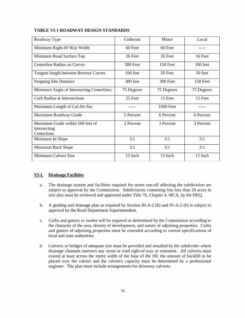
76
TABLE VI-1 ROADWAY DESIGN STANDARDS
VI-I. Drainage Facilities
a. The drainage system and facilities required for storm run-off affecting the subdivision are
subject to approval by the Commission. Subdivisions containing lots less than 20 acres in
size also must be reviewed and approved under Title 76, Chapter 4, MCA, by the DEQ.
b. A grading and drainage plan as required by Section III-A-2 (6) and IV-A-2 (6) is subject to
approval by the Road Department Superintendent.
c. Curbs and gutters or swales will be required as determined by the Commission according to
the character of the area, density of development, and nature of adjoining properties. Curbs
and gutters of adjoining properties must be extended according to current specifications of
local and state authorities.
d. Culverts or bridges of adequate size must be provided and installed by the subdivider where
drainage channels intersect any street or road right-of-way or easement. All culverts must
extend at least across the entire width of the base of the fill; the amount of backfill to be
placed over the culvert and the culvert's capacity must be determined by a professional
engineer. The plan must include arrangements for driveway culverts.
Roadway Type Collector Minor Local
Minimum Right-0f-Way Width 60 Feet 60 Feet -----
Minimum Road Surface Top 26 Feet 26 Feet 16 Feet
Centerline Radius on Curves 300 Feet 150 Feet 100 feet
Tangent length between Reverse Curves 100 feet 50 Feet 50 feet
Stopping Site Distance 300 feet 300 Feet 150 Feet
Minimum Angle of Intersecting Centerlines 75 Degrees 75 Degrees 75 Degrees
Curb Radius at Intersections 25 Feet 15 Feet 15 Feet
Maximum Length of Cul-De-Sac ----- 1000 Feet -----
Maximum Roadway Grade 5 Percent 6 Percent 6 Percent
Maximum Grade within 100 feet of
Intersecting
Centerlines
2 Percent 3 Percent 3 Percent
Minimum In Slope 3:1 3:1 3:1
Minimum Back Slope 3:1 3:1 3:1
Minimum Culvert Size 15 Inch 15 Inch 15 Inch
77
e. The subdivider must provide suitable drainage facilities for any surface runoff affecting the
subdivision; these facilities must be located in street rights-of-way or in perpetual
easements of appropriate widths and are subject to approval by the Commission.
f. Each culvert or other drainage facility must be large enough to accommodate potential
runoff from upstream drainage areas.
g. Drainage systems must not discharge into any sanitary sewer facility.
h. The grading and drainage system must be designed and certified by a professional engineer.
i. The Commission may require the subdivider to grant easements to prevent encroachment or
disruption of drainage ways or facilities. Drainage easements must be drawn on the plat
and a signed statement granting the easements must appear on the plat.
VI-J. Water Supply Systems
For subdivisions that will create one or more parcels containing less than 20 acres, the
proposed method of supplying domestic water to each lot in the subdivision must comply
with the design standards adopted by the Montana DEQ and contained in the
Administrative Rules of Montana (ARM) 17.36.330, 17.36.331, 17.36.332, 17.36.333,
17.36.334, 17.36.335 and 17.36.336. By this reference these DEQ standards are
incorporated into and made a part of these regulations. Unless defined elsewhere in these
regulations, the terms used in these standards will have the meanings assigned to them in
ARM 17.36.101.
The governing body may not approve the final plat of a subdivision containing lots of
less than 20 acres in size, unless the subdivision has been approved by DEQ or other
authorized reviewing authority under the Sanitation in Subdivisions Act, sections 76-4-
101 et seq., MCA.
If the lots are 20 acres or greater in size, the subdivider shall demonstrate that there is an
adequate water source on each lot prior to final plat approval.
Any central water supply system must provide adequate and accessible water for fire
protection.
VI-K. Sewage Treatment Systems
a. For subdivisions that will create one or more parcels containing less than 20 acres, the
proposed method of disposing of sewage from each lot in the subdivision must comply
with the design standards adopted by the DEQ and contained in the Administrative Rules
of Montana (ARM) 17.36.319, 17.36.320, 17.36.321, 17.36.322, 17.36.323,
17.36.324, 17.36.325, 17.36.326, 17.36.327 and 17.36.328. By this
reference these DEQ standards are incorporated into and made a part of these
regulations. Unless defined elsewhere in these regulations, the terms used in these
standards will have the meanings assigned to them in ARM 17.36.101.
b. For subdivisions that will create one or more parcels containing less than 20 acres, the
subdivision must have been approved by DEQ or other authorized reviewing authority

78
under the Sanitation in Subdivisions Act, sections 76-4-101 et seq., MCA before the
governing body can approve the final plat.
c. For subdivisions containing parcels containing 20 acres or more, the subdivider shall
demonstrate that there is an adequate water source and at least one area for a septic
system and a replacement drain field for each lot before the governing body may approve
the final plat.
VI-L. Solid Waste
a. For subdivisions that will create one or more parcels containing less than 20 acres, the
proposed method of must comply with the standards adopted by the DEQ and contained
in the Administrative Rules of Montana (ARM) 17.36.309. By this reference this DEQ
standard is incorporated into and made a part of these regulations. Unless defined
elsewhere in these regulations, the terms used in these standards will have the meanings
assigned to them in ARM 17.36.101.
c. Before the governing body will approve the final plat of a subdivision containing lots of
less than 20 acres in size, the subdivision must have been approved by the DEQ or other
authorized reviewing authority under the Sanitation in Subdivisions Act sections 76-4-
101, et seq., MCA.
c. For subdivisions that will create one or more parcels containing 20 acres ore more and
less than 160 acres, the proposed method of storing and disposing of solid waste
generated within the subdivision in the subdivision must comply with the local
environmental health department regulations.
VI-M. Utilities
a. The subdivider must provide adequate and appropriate easements for the construction and
maintenance of utilities within the subdivision. The subdivider must obtain any
easements necessary to extend utilities to the subdivision.
b. Utilities must be placed underground, wherever practical. Underground utilities, if
placed in a street right-of-way, must be located between the roadway and the right-of-
way line to simplify location and repair of lines. Underground facilities must be installed
after the street has been brought to grade and before it is surfaced.
c. Where practical, overhead utility lines must be located at the rear property line.
d. Utility facilities must be designed by utility firms in cooperation with the subdivider.
These facilities are subject to all applicable laws, rules, and regulations of the appropriate
regulatory authorities.
e. Utility easements located between adjoining lots must be centered on lot lines. If
easements are placed in the street, they must be located between the roadway and the
right-of-way line.
79
f. Utility easements must be 15 feet wide unless otherwise specified by a utility company or
governing body.
g. When a utility is to be located in an existing, dedicated right-of-way, a notice of utility
occupancy must be obtained from the governing body, or local or state highway
department.
h. In addition to showing the location of utility easements on the plat with dashed lines, the
following statement must appear on the final plat:
“The undersigned hereby grants unto each and every person, firm, or corporation,
whether public or private, providing or offering to provide telephone, telegraph, electric
power, gas, cable television, water or sewer service to the public, the right to the joint use
of an easement for the construction, maintenance, repair and removal of their lines and
other facilities, in, over, under and across each area designated on this plat as ‘Utility
Easement’ to have and to hold forever.”
VI-N. Water Course and Irrigation Easements
a. Except as noted in subsection (b), below, the subdivider shall establish within the
subdivision ditch easements that:
i. are in locations of appropriate topographic characteristics and sufficient width to
allow the physical placement and unobstructed maintenance of open ditches or
below ground pipelines for the delivery of water for irrigation to persons and
land legally entitled to the water under an appropriated water right or permit of
an irrigation district or other private or public entity formed to provide for the use
of the water right on the subdivision lots;
ii. are a sufficient distance from the centerline of the ditch to allow for construction,
repair, maintenance, and inspection of the ditch; and
iii. prohibit the placement of structures or the planting of vegetation other than grass
within the ditch easement without the written permission of the ditch owner.
b. The subdivider need not establish irrigation easements as provided above if:
i. the average lot size in the proposed subdivision will be one acre or less and the
subdivider provides for disclosure, in a manner acceptable to the governing body,
notifying potential buyers that lots within the subdivision are classified as
irrigated land and may continue to be assessed for irrigation water delivery even
though the water may not be deliverable to the lots; or
ii. the water rights have been removed from the land within the subdivision or the
process has been initiated to remove the water rights from the subdivided land;
and
iii. the fact the water rights have been or will be removed from the land within the
subdivision is denoted on the preliminary plat. If the removal of water rights has

80
not been completed at the time the final plat is filed, the subdivider shall provide
written notification to prospective buyers of the subdivider’s intention to remove
the water right and shall document that intent, when applicable, in agreements
and legal documents for related sales transactions.
c. The subdivider shall, unless otherwise provided under separate written agreement or filed
easement, show on the preliminary and final plat, and file and record with the county
clerk and recorder, ditch easements for the unobstructed use and maintenance of existing
water delivery ditches, pipelines, and facilities in the proposed subdivision that are
necessary to convey water through the subdivision to lands adjacent to or beyond the
subdivision boundaries in quantities and in a manner that are consistent with historic and
legal rights. A minimum width of 10 feet is required on each side of irrigation canals and
ditches for maintenance purposes.
VI-O. Disposition of Water Rights
If a subdivision will create lots averaging less than five acres in size, the subdivider shall submit
evidence with the final plat that the subdivider has:
a. reserved all or a portion of the appropriation water rights owned by the owner of the land
to be subdivided and transfer these water rights to a single entity for use by landowners
within the subdivision who have a legal right to the water and reserved and severed any
remaining surface water rights from the land;
b. if the land to be subdivided is subject to a contract or interest in a public or private entity
formed to provide for the use of a water right on the subdivision lots, established a
landowner’s water use agreement administered through a single entity. This agreement
must specify how the water rights will be administered and describe the rights and
responsibilities of landowners within the subdivision who have a legal right and access to
the water; or
c. reserved and severed all surface water rights from the land proposed for subdivision.
VI-P. Park Land Dedication – Cash in Lieu – Waivers -- Administration
a. Except as provided below, the final plat of a residential subdivision must show that the
subdivider has dedicated to the governing body a cash or land donation equal to:
i. 11% of the area of the land proposed to be subdivided into parcels of one-
half acre or smaller;
ii. 7.5% of the area of the land proposed to be subdivided into parcels larger than
one-half acre and not larger than one acre;
iii. 5% of the area of the land proposed to be subdivided into parcels larger than one
acre and not larger than three acres; and
iv. 2.5% of the area of the land proposed to be subdivided into parcels larger than
three acres and not larger than five acres.
b. A park dedication is not required for:
81
i. minor subdivisions;
ii. subdivision lots larger than five acres;
iii. nonresidential subdivision lots;
iv. subdivisions in which parcels of land will not be created, other than subdivisions
that will provide permanent multiple spaces for recreational camping vehicles,
mobile homes, or condominiums; or
v. subdivisions which will create only one additional parcel.
c. The governing body, in consultation with the subdivider and the planning board or park
board that has jurisdiction, may determine suitable locations for parks and playgrounds
and, giving due weight and consideration to the expressed preference of the subdivider,
may determine whether the park dedication must be a land donation, cash donation, or a
combination of both. When a combination of land donation and cash donation is
required, the cash donation may not exceed the proportional amount not covered by the
land donation. The land dedicated for park use may be inside or outside the boundaries
of the proposed subdivision.
d. The governing body will waive the park dedication requirement if it determines that:
i. A. the preliminary plat provides for a planned unit development or other development with land permanently set aside for park and recreational
uses sufficient to meet the needs of the persons who will ultimately
reside in the development; and
B. the area of the land and any improvements set aside for park and
recreational purposes equals or exceeds the area of the dedication
required under subsection VI-P (a);
ii A. the proposed subdivision will provide for the long-term protection of
critical wildlife habitat; cultural, historical, or natural resources;
agricultural interests; or aesthetic values; and
B. the provision of this long-term protection will result in the reduction
of the area of the land proposed to be subdivided by an amount equal
to or exceeding the area that would have had to be dedicated under
subsection VI-P(a) above;
iii. the area of the land proposed to be subdivided, by virtue of a
combination of the provisions of subsections (d)(i) and (ii) above, is
reduced by an amount equal to or exceeding the area of the dedication
required under subsection VI-P(a); or
iv. A. the subdivider provides for land outside of the subdivision to be set aside
for park and recreational uses sufficient to meet the needs of the persons
who will ultimately reside in the subdivision; and

82
B. the area of the land and any improvements set aside for park and
recreational uses equals or exceeds the area of dedication required under
subsection VI-P(a).
e. The local governing body may waive the park dedication requirement if:
i. the subdivider provides land outside the subdivision that affords long-term
protections of critical wildlife habitat, cultural, historical, or natural resources,
agricultural interests, or aesthetic values; and
ii. The area of land to be subject to long-term protection, as provided in subsection
(e)(i), equals or exceeds the area of dedication required under subsection VI-P(a).
f. Subject to the approval of the local governing body and acceptance by the school district
trustees, a subdivider may dedicate a land donation provided under subsection VI-P(a) to
a school district, adequate to be used for school facilities or buildings.
g. The governing body will administer funds dedicated to the public under this section in
accordance with 76-3-621, MCA.
h. For the purposes of this park dedication requirement:
i. “cash donation” means the fair market value of the unsubdivided, unimproved
land; and
ii. “dwelling unit” means a residential structure in which a person or persons reside.
VI-Q. Fire Protection
Fire hazard designation may be determined by the local fire protection authority, the Community
Wildfire Plan, or an independent assessment. The County will give preference to the designation
set by the local fire protection authority.
All subdivisions must be planned, designed, constructed, and maintained so as to minimize the
risk of fire and to permit the effective and efficient suppression of fires in order to protect
persons, property, and forested areas. Measures must also include:
a. The placement of structures so as to minimize the potential for flame spread and to
permit adequate access for firefighting equipment.
b. Subdivisions must show presence of on-site or off-site water sources. All water sources,
whether on-site or off-site must be approved by the local fire jurisdiction prior to
preliminary plat application. A letter from the local fire jurisdiction verifying water
source approval must accompany the preliminary plat application. Subdivision may
provide payment for development of off-site water sources to the Custer County. On-site
water may be required as determined by Custer County.
c. Wildland-Urban Interface Best Practices: Custer County request land owners,
developers, and subdividers with land in the Wildland-Urban Interface areas of Custer
83
County, read and understand the Montana Department of Natural Resources and
Conservation (DNRC) “Guidelines for Development within the Wildland-Urban
Interface” publication of September 24, 2009, and FEMA a Publication P-737 “Home
Builder’s Guide to Construction in Wildfire Zones” publication of September 2008.
VI-R. Special Requirements for Subdivisions Proposed in Areas of High Fire Hazard
For areas identified as wildfire hazard areas by the United States Forest Service, the Montana
Department of Natural Resources and Conservation, a local fire protection authority, or a local
growth policy, the following apply:
a. A Fire Prevention and Control Plan approved by the local f ire service area or
fire district must accompany the submission of any application for preliminary plat
approval.
b. The Fire Prevention and Control Plan must include the following items:
i. an analysis of the wildfire hazards on the site, as influenced by existing
vegetation and topography;
ii. a map showing the areas that are to be cleared of dead, dying, or severely
diseased vegetation, including a continued vegetation management plan;
iii. a map of the areas that are to be thinned to reduce the interlocking canopy of
trees;
iv. the identification of roads and bridges that are sufficient for emergency
vehicle access and fire suppression activities. Slopes of all roads and driveways
must be provided. Snow removal areas outside of ditches must be provided.
v. A map showing building envelopes;
vi. Covenant(s) requiring compliance with the Wildland Urban Interface guidelines
including:
a) Survivable space as defined by current fire standards,
b) Additional on-site water requirements as identified by the local fire district
or fire service area;
c) Fuel breaks and greenbelts;
d) Covenant demonstrating continual compliance with survivable space
standards.
c. At least two entrances/exits must provide escape routes for residents and access to the
subdivision by fire-fighting vehicles for subdivisions of 15 lots or where identified by the
local fire protection authority. In-line cul-de-sacs may be considered for accessing 14 lots
or less, In-line cul de sacs shall be built with a minimum right-of-way radius of 75 feet
and a minimum roadway radius of 60 feet. The governing body must review gates for
subdivisions proposed to be gated. Bridges providing access to the subdivision must be
84
built to a design load of 20 tons and constructed of non-flammable materials. Road
rights-of-way must be cleared of slash.
d. Building sites may not be located on slopes greater than 25 percent or at the apex of “fire
chimneys” (topographic features, usually drainageways or swales, which tend to funnel
or otherwise concentrate fire toward the top of steep slopes). Areas of 25 percent slope or
more shall be noted on the plat as unbuildable.
e. Provisions for the maintenance of the fire guidelines shall be included in the covenants,
conditions, and restrictions for the development. A property owners’ association must
be formed and designated to enforce the covenants, conditions, and restrictions.
f. pen space, park land, and recreation areas (including green belts, riding or hiking trails)
should be located, where appropriate, to separate residences and other buildings from
densely forested areas.
g. A water supply of sufficient volume for effective fire control must be provided in
accordance with standards set by the appropriate local fire protection authority.
h. The availability, through a fire protection district or contract of services with a fire district,
of fire protection services adequate to respond to fires that may occur within the
subdivision.
VI-S. Noxious Weeds
A weed control plan shall be developed and implemented for every new subdivision. An
agreement with the Custer County Weed Control Board shall be signed and notarized by the
subdivider, and the agreement must be recorded with the final plat.
85
VII. AREAS THAT WILL PROVIDE MULTIPLE SPACES FOR RECREATIONAL
CAMPING VEHICLES OR MOBLE HOMES
VII-A. Definition
A subdivision includes an area, regardless of its size, that provides or will provide multiple spaces
for rent or lease on which recreational camping vehicles or mobile homes will be placed. The land
is owned, however, as one parcel under single ownership (which can include a number of persons
owning property in common).
VII-B. Subdivisions That Will Provide Multiple Spaces for Recreational Camping
Vehicles or Mobile/Manufactured Homes
a. Recreational Camping Vehicles
Developments which are subject to subdivision review because they will provide two or
more spaces for recreational camping vehicles will be reviewed under section VII-F
Recreational Vehicle Park Standards, below.
b. Mobile/Manufactured Homes
Developments which are subject to subdivision review because they will provide two or
more spaces for mobile/manufactured homes will be reviewed under section VII-E
Mobile/Manufactured Home Park Standards, below.
c. Mobile Home/Recreational Vehicle Parks
i. Mobile home and recreational vehicle parks will be reviewed under the
procedures described in Section IV, Major Subdivisions, or Section III, Minor
Subdivisions, as may be appropriate.
ii. Mobile home and recreational vehicle parks are subject to the applicable
standards contained in Section VI.
VII-C. Procedures for Review
VII-C-1. Review and Approval
Subdivisions which will provide multiple spaces for recreational camping vehicles or mobile
homes are exempt from the surveying and filing requirements of the MSPA. However, they must
be submitted for review and approved by the governing body before spaces may be rented or
leased.
a. Submittal
The subdivider shall submit a completed application in accordance with Section II-A-5.

86
b. Review
The procedure used to review subdivisions for mobile home and recreational vehicle
parks will depend on the number of spaces within the proposed subdivision. Proposed
subdivisions containing six or more spaces must be reviewed pursuant to Section IV of
these regulations. Proposed subdivisions containing five or fewer spaces must be
reviewed pursuant to Section III of these regulations. The subdivider shall submit to the
subdivision administrator the preliminary plat, profiles, tentative grades, and
specifications for proposed improvements. The plat must show the space layout and the
proposed location of the mobile home, recreational vehicle, or other unit on the land
included in the plan.
VII-C-2. Improvements
The subdivider shall install all required improvements before renting or leasing any portion of the
subdivision. The governing body or its agents will inspect all required improvements in order to
assure conformance with the approved construction plans and specifications.
VII-C-3. Final Plat Review
The subdivider shall submit a final plat to the subdivision administrator complying with the
requirements of Final Plats in Section II.
VII-C-4. DPHHS License
If a subdivision that will provide multiple spaces for recreational camping vehicles or mobile
homes is also a “trailer court,” “work camp,” “youth camp,” or “campground” as those terms are
defined in section 50-52-102, MCA, the governing body will not grant final approval of the
subdivision until the subdivider obtains a license for the facility from the Montana Department of
Public Health and Human Services under Title 50, Chapter 52, MCA.
VII-D. Design Standards for Subdivision Spaces Created by Rent or Lease
VII-D-1. Design Standards
Mobile home and recreational vehicle parks must comply with the provisions of Section VI.
VII-D-2. Additional Provisions
The governing body may require provision for:
a. storage facilities on the lot or in compounds located within a reasonable distance;
b. a central area for storage or parking of boats, trailers, or other recreational vehicles;
c. landscaping or fencing to serve as a buffer between the development and adjacent
properties;

87
d. an off-street area for mail delivery; and
e. street lighting.
VII-E. Mobile/Manufactured Home Park Standards
VII-E-1. Mobile/Manufactured Home Spaces
a. Mobile/manufactured home spaces must be arranged to permit the safe and practical
placement and removal of mobile homes.
b. All mobile/manufactured homes must be located at least 25 feet from any property
boundary line abutting upon a public street or highway right-of-way and at least 15 feet
from other boundary lines of the park.
c. The mobile/manufactured home pad must be located at least 10 feet from the street that
serves it.
d. The size of the mobile/manufactured home pad must be suitable for the general market to
be served and must fit the dimensions of mobile/manufactured homes anticipated.
e. A mobile/manufactured home pad may not occupy more than one-third (1/3) of the area
of its space. The total area occupied by a mobile home and its roofed accessory buildings
and structures may not exceed two-thirds (2/3) of the area of a space.
f. The governing body may require that the mobile/manufactured home pad be improved to
provide adequate support for the placement and tie-down of the mobile home.
g. No mobile/manufactured home or its attached structures, such as awnings and carports,
may be located within 20 feet of any other mobile home or its attached structures.
h. No detached structure, such as a storage shed, may be located within five feet of any
mobile/manufactured home or its attached structures.
i. A minimum of two off-street parking spaces must be provided on or adjacent to each
mobile/manufactured home space. The driveway must be located to allow for convenient
access to the mobile/manufactured home, and be a minimum of 10 feet wide.
j. One guest parking space must be provided for each 10 mobile/manufactured home
spaces. Group parking may be provided.
k. The limits of each mobile/manufactured home space must be clearly marked on the
ground by permanent flush stakes, markers or other suitable means. Location of space
limits on the ground must be approximately the same as those shown on the approved
plans. Precise engineering of space limits is not required either on the plans or on the
ground.
88
l. Each mobile/manufactured home must be skirted within 30 days after it is moved to a
space within the mobile/manufactured home park. The skirting must be of a fire-resistant
material similar to that of the mobile/manufactured home exterior.
VII-E-2. Streets
Streets within a mobile/manufactured home park must meet the standards specified in Section VI-
H Streets and Roads. Streets must be designed to allow safe placement and removal of mobile
homes.
a. Streets must be designed to provide safe access to public roads.
b. Roads within the mobile/manufactured home park must be designed to provide safe
traffic circulation and parking.
c. One-way roads must be at least 15 feet wide; two-way roads must be at least 24 feet
wide.
VII-E-3. Electrical Systems
Electrical systems must be designed and installed in accordance with the applicable codes
adopted by the authority having jurisdiction. Where the state or other political subdivision does
not assume jurisdiction, such installations must be designed and constructed in accordance with
the applicable state electrical standards.
VII-E-4. Gas Systems
a. Gas equipment and installations must be designed and constructed in accordance with the
applicable codes adopted by the authority having jurisdiction. Where the state or other
political subdivision does not assume jurisdiction, such installation must be designed and
constructed in accordance with the applicable provisions of the “National Fuel Gas Code”
(NFPA Pamphlet 54-1981) and the “Standard for the Storage and Handling of Liquefied
Petroleum Gases” (NFPA Pamphlet 58-1981).
b. A readily accessible and identified shutoff valve controlling the flow of gas to the entire
gas piping system must be installed near to the point of connection of the liquefied
petroleum gas container.
c. Each mobile/manufactured home lot must have an accessible, listed gas shutoff installed.
This valve must not be located under a mobile home. Whenever the mobile home lot gas
outlet is not in use, the shutoff valve must be plugged to prevent accidental discharge.
VII-F. Recreational Vehicle Park Standards
VII-F-1. Recreational Vehicle Spaces
a. Spaces in recreational vehicle parks must be arranged to allow for the safe movement of
traffic and access to spaces.

89
b. Roads within recreational vehicle parks must be designed to provide safe traffic
circulation and parking.
c. Recreational vehicles must be separated from each other and from other structures by at
least 15 feet. Any accessory structures such as attached awnings must, for purposes of
this separation requirement, be considered part of the recreational vehicle.
d. No recreational vehicle space may be located less than 25 feet from any public street or
highway right-of-way.
VII-F-2. Density
The density of a recreational vehicle park must not exceed 25 recreational vehicle spaces per acre
of gross site area.
90
VIII. PLANNED UNIT DEVELOPMENTS
VIII-A. Purpose
The purpose of this section is to provide flexibility in applying certain subdivision standards,
allowing the subdivider creativity in subdivision design. Section 76-3-103(10), MCA defines a
planned unit development as “a land development project consisting of residential clusters,
industrial parks, shopping centers or office building parks that compose a planned mixture of land
uses built in a prearranged relationship to each other and having open space and community
facilities in common ownership or use.”
VIII-B. Procedures
If the governing body designates a proposed development plan as a PUD, the preliminary plat
may then be submitted for review. Submittal must comply with requirements and procedures
contained in the following Sections:
IV. Major Subdivisions
II-B. Applicable sections for Final Plats
VIII-C. Standards
VIII-C-1. Design Standards
PUDs must comply with the standards contained in Section VI Design and Improvement
Standards. However, the governing body may modify the design and improvement standards
contained in Section VI-F Lots, Section VI-G Blocks, Section VI-H Streets and Roads, and
Section VI-P Park Land Dedication upon request of the subdivider when the plan for a PUD
includes provisions for efficient traffic circulation, adequate light, air, and open space. In such
cases, no application for a variance under Section XI-B Variances of these regulations is
necessary.
VIII-C-2. Streets
The arrangement, type, extent, width, grade and location of all streets must be considered in their
relation to existing and planned streets, to topographical conditions, and to public convenience
and safety.
VIII-C-3. Open Space
Each PUD must comply with the requirements of Section VI-P(d) of these regulations. The open
space must be:
a. Owned by a property owners’ association; or
b. Dedicated to public use, if acceptable to the governing body; or

91
c. A combination of (a) and (b) above.
The governing body may waive dedication or cash donation requirements when the subdivider
agrees to create a property owners’ association for the proposed subdivision and deed to the
association land to be held in perpetuity for use as parks or playgrounds.
92
CONDOMINIUMS
IX-A. Procedures
Unless exempted by section 76-3-203, MCA, all condominium developments are subdivisions
subject to the terms of the MSPA as follows:
IX-A-1. Review Where Land Will Not Be Divided
If no division of land will be created by a condominium subdivision, the subdivision must be
reviewed under the procedures contained in Section VII, with the following exception: final
approval will not be given until the subdivider has either installed all required improvements, or
has entered into a subdivision improvements agreement pursuant to Section II-B-4 Public
Improvements Agreement; Guaranty.
IX-A-2. Condominium Subdivisions Involving Land Divisions
If a proposed condominium development will involve a division of land, the subdivision must be
reviewed under the procedures contained in Sections:
IV-A Review and Approval Procedures for Major Subdivisions
II-B Applicable sections for Final Plats.
IX-B. Standards
IX-B-1. Design Standards
Condominium developments must comply with applicable standards contained in Section VI,
Design and Improvement Standards.
IX-B-2. Unit Ownership Act
Condominium developments must comply with all provisions of the Unit Ownership Act,
Sections 70-23-102 through 70-23-703, MCA.

93
IX. CLUSTER DEVELOPMENT
The governing body has adopted a growth policy that meets the requirements of 76-1-601, MCA,
and further adopts the following to promote cluster development and preserve open space.
X-A. Cluster Development - Standards
a. If a proposed subdivision meets the following cluster development standards then the
governing body will make a finding that the development will not have an adverse impact
on the 76- 3-608(3)(a) criteria and therefore the subdivision application does not need
to complete an environmental assessment. Cluster development standards:
i. The proposed subdivision clusters structures together and away from open space;
ii. Open space abuts neighboring open space and protects the most important and
critical agricultural lands and wildlife habitat and corridors on the property;
iii. Open space constitutes at least 50% of the development's property including all
past and proposed future phases of the development;
iv. Multiple adjacent tracts of record may be aggregated to create a single parcel for
the purpose of creating a cluster development;
v. There is no minimum lot size other than those authorized under administrative
rules adopted by the DEQ under Title 76, Chapter 4, MCA;
vi. The maximum size of parcels, not designated as open space, allowed within a
cluster development is five acres;
v. The development complies with all applicable zoning, subdivision, and building
code regulations and state laws; and
vi. Open space may contain dedicated parkland, wildlife, river, and stream buffers,
and up to 1/3 of open space areas may be used for community water and
community wastewater systems. 100-year floodplains and hillsides with slopes
greater than 25% must be subtracted from the total amount of required open
space.
vii. Land protected as open space on a long-term basis must be identified on the final
subdivision plat, and the plat must include a copy of or a recording reference to
the irrevocable covenant prohibiting further subdivision, or development of the
open space lots or parcels, as provided in Title 70, chapter 17.
b. A cluster development receives the following incentives:
i. Density bonuses allowing the developer to build:
A. 50% more units/lots than allowed under zoning if 50% to 75% of the
development is placed in a perpetual conservation easement;

94
B. 100% more units/lots than allowed under zoning if 75% or more of the
development is placed in a perpetual conservation easement;
ii. If a proposed subdivision meets the cluster development standards under (a) then
the governing body will make a finding that the development will not have an
adverse impact on the 76-3-608(3)(a) criteria and therefore the subdivision
application does not need to complete an EA.
iii. Park dedication requirements for clustered subdivision created under this section
are waived.
95
X. ADMINISTRATIVE PROVISIONS
XI-A. Fee Schedule
Review fees shall be paid to the County for each submittal reviewed according to the fee
schedule approved by the Commission under a separate document.
XI-B. Variances
XI-B-1. Variances Authorized
The governing body may grant variances from Section VI, Design and Improvement Standards,
of these regulations when, due to the characteristics of land proposed for subdivision, strict
compliance with these standards would result in undue hardship and would not be essential to the
public welfare. A variance will not be granted if it would have the effect of nullifying the intent
and purpose of these regulations.
The Planning Board or the County Commissioners will conduct a public hearing on any variance
request for all major subdivisions prior to taking action on the preliminary plat application.
The governing body will not approve a variance unless it finds that:
a. The granting of the variance will not be detrimental to the public health, safety, or
general welfare or injurious to other adjoining properties;
b. Due to the physical surroundings, shape, or topographical conditions of the property
involved, strict compliance with the regulations will impose an undue hardship on the
owner. Undue hardship does not include personal or financial hardship, or any hardship
that is self-imposed;
c. The variance will not cause a substantial increase in public costs; and
d. The variance will not place the subdivision in nonconformance with any adopted zoning
regulations.
XI-B-2. Variances from Floodway Provisions Not Authorized
The governing body will not by variance permit subdivision for building purposes in areas
located within the floodway of a flood of 100-year frequency as defined by Title 76, Chapter 5,
MCA.
XI-B-3. Procedure
The subdivider shall include with the submission of the preliminary plat a written statement
describing and justifying the requested variance. The planning board will consider the requested
variance and recommend its approval or denial to the governing body.
96
XI-B-4. Conditions
In granting variances, the governing body may impose reasonable conditions to secure the
objectives of these regulations.
XI-B-5. Statement of Facts
When a variance is granted, the motion to approve the proposed subdivision must contain a
statement describing the variance and the facts and conditions upon which the issuance of the
variance is based.
XI-C. Amendment of Regulations
Before the governing body amends these regulations it will hold a public hearing on the proposed
amendment. Notice of the time and place of the public hearing must be published in a newspaper
of general circulation in the county not less than 15 days or more than 30 days before the date of
the hearing.
XI-D. Administration
XI-D-1. Enforcement
Except as provided in 76-3-303, MCA, and these regulations, every final subdivision plat must be
filed for record with the county clerk and recorder before title to the subdivided land can be sold
or transferred in any manner. If unlawful transfers are made, the county attorney shall commence
action to enjoin further sales or transfers and compel compliance with all provisions of the MSPA
and these regulations. The cost of this action shall be imposed against the party not prevailing.
XI-D-2. Violation and Penalties
Any person, firm, corporation, or other entity who violates any of the provisions of the MSPA or
these regulations is guilty of a misdemeanor punishable by a fine of not less than $100 nor more
than $500 or by imprisonment in jail for not more than three months or by both fine and
imprisonment. Each sale, lease, or transfer, or offer of sale, lease, or transfer of each separate
parcel of land in violation of any provision of the MSPA or these regulations shall be deemed a
separate and distinct offense.
XI-D-3. Appeals
a. A person who has filed with the governing body an application for a subdivision under
the MSPA and these regulations may bring an action in district court to sue the governing
body to recover actual damages caused by a final action, written decision, or order of the
governing body or a regulation adopted pursuant to the MSPA that is arbitrary or
capricious.
b. A party identified in subsection (d) below who is aggrieved by a written decision
of the governing body to approve, conditionally approve, or deny an application
and preliminary plat for a proposed subdivision or a final subdivision plat may,

97
within 30 days after the written decision, appeal to the district court in the county in
which the property involved is located. The petition must specify the grounds upon
which the appeal is made.
c. For the purposes of this section, “aggrieved” means a person who can demonstrate a
specific personal and legal interest, as distinguished from a general interest, who has been
or is likely to be specially and injuriously affected by the written decision.
d. The following parties may appeal under the provisions of subsection (b) above:
i. the subdivider;
ii. a landowner with a property boundary contiguous to the proposed subdivision or
a private landowner with property within the county or municipality where the
subdivision is proposed if that landowner can show a likelihood of material
injury to the landowner's property or its value;
iii. the county commissioners of the county where the subdivision is proposed; and
iv. one of the following municipalities:
A. a first-class municipality as described in 7-1-4111, if a subdivision is
proposed within 3 miles of its limits;
B. a second-class municipality, as described in 7-1-4111, if a subdivision is
proposed within 2 miles of its limits;
C. a third-class municipality, as described in 7-1-4111, if a subdivision is
proposed within 1 mile of its limits.
APPENDIX A
UNIFORM STANDARDS FOR MONUMENTATION,
CERTIFICATES OF SURVEY, AND FINAL SUBDIVISION PLATS
24.183.1101 UNIFORM STANDARDS FOR MONUMENTATION
(1) The following standards govern the monumentation of land surveys: (a) The terms "monument" and "permanent monument" as used in these regulations mean any
structure of masonry, metal or other permanent, durable material placed in the ground,
which is exclusively identifiable as a monument to a survey point, expressly placed for
surveying reference.
(b) All metal monuments must be at least one-half inch in diameter and 18 inches in length with a
cap not less than one inch in diameter marked in a permanent manner with the license
number of the surveyor in charge of the survey and either the name of the surveyor or the
company employing the surveyor. Metal monuments marking a public land survey
corner as described in 70-22-101 , MCA, must be at least 24 inches long and 5/8 inch in
diameter with an appropriately stamped metal cap at least two inches in diameter. A
monument marking a public land survey corner may also consist of a cap as described in
this rule set firmly in concrete.
(c) Before a subdivision plat or certificate of survey may be filed for record the surveyor shall
confirm the location of as many monuments as, in the surveyor's professional judgment,
are necessary to reasonably assure the perpetuation of any corner or boundary established
by the survey and to enable other surveyors to reestablish those corners and boundaries
and retrace the survey. The surveyor shall clearly identify on the face of the plat or
certificate of survey all monuments pertinent to the survey, and the descriptions of these
monuments must be sufficient to identify the monuments.
(d) The surveyor shall set all monuments prior to the filing of a plat or certificate of survey except
those monuments that will be disturbed by the installation of improvements or that,
because of severe weather conditions, may, in the surveyor's judgment, be more
appropriately and accurately set after the weather has improved. In these two
circumstances the surveyor may set monuments after the survey document is filed if the
surveyor certifies on the survey document that the monuments will be set by a specified
date. The surveyor shall set monuments, the placement of which has been deferred
because of severe weather conditions, within 240 days of the date on which the survey
document was filed.
(i) If during the later monumentation of the corners of a plat or certificate of survey that
were not monumented before the plat or certificate was filed, the surveyor finds
that it is necessary to set a reference monument to a corner, the surveyor shall
prepare and file an amended certificate of survey or subdivision plat.
(ii) The failure of the surveyor to set the monuments by the date certified on the record of
survey will be deemed a violation of these rules.
(e) The surveyor shall set monuments at the following locations: (i) At each corner and angle point of all lots, blocks and parcels of land created by the
survey.
(ii) At every point of intersection of the outer boundary of a subdivision with an existing
road right-of-way line of record or a road right-of-way line created by the survey.
(iii) At every point of curve, point of tangency, point of reversed curve, point of
compounded curve and point of intersection on each road right-of-way line
created by the survey.
(iv) At the intersection of a boundary line and a meander line. Meander line angle points
need not otherwise be monumented.
(f) If the placement of a required monument at its proper location is physically impractical, the
surveyor may set a reference or witness monument. This monument has the same status
as other monuments of record if its location is properly shown. If the surveyor relies
upon any existing monument in conducting a survey, he or she shall confirm the location
of the monument and show and describe it on the resulting certificate of survey or
subdivision plat.
History: 76-3-403, MCA; IMP, 76-3-403, MCA; NEW, Eff. 1/5/74; EMERG, AMD, Eff. 7/1/74; AMD, Eff. 10/5/74; AMD,
1980 MAR p. 2806, Eff. 10/17/80; TRANS, from Dept. of Comm. Affairs, Ch. 274, L. 1981, Eff. 7/1/81; AMD, 2000
MAR p. 462, Eff. 2/11/00; TRANS, from Commerce, 2005 MAR p. 966.
24.183.1104 UNIFORM STANDARDS FOR CERTIFICATES OF SURVEY
(1) A certificate of survey must comply with the following requirements: (a) A certificate of survey must be legibly drawn with permanent black ink or printed or
reproduced by a process guaranteeing a permanent record and must be 18 inches by 24
inches or 24 inches by 36 inches. Margins must be a minimum 1/2-inch on all sides, or as
required by the filing office.
(b) One original on three mil or heavier matte stable-base polyester film or equivalent and/or one
original on 24# white bond paper or equivalent must be submitted, or on such medium as
required by the filing office.
(c) If more than one sheet must be used to adequately depict the land surveyed, each sheet must
show the number of that sheet and the total number of sheets included. All certifications
must be placed on sheet number one of the certificate of survey.
(d) A certificate of survey must show or contain the following information: (i) a title or title block including the quarter-section, section, township, range, principal
meridian, county, and if applicable, city or town in which the surveyed land is
located. Except as provided in (1)(f)(v), a certificate of survey must not contain
the title "plat," "subdivision," or any title other than "Certificate of Survey";
(ii) the name(s) of the person(s) who commissioned the survey, the name(s) of the
owner(s) of the land surveyed, if other than the person(s) commissioning the
survey, the names of any adjoining plats, and the numbers of any adjoining
certificates of survey previously filed;
(iii) he date the survey was completed and a brief explanation of why the certificate of
survey was prepared, such as to create a new parcel, retrace a section line, or
retrace an existing parcel of land;
(iv) orth arrow; (v) ) a scale bar. The scale of the certificate of survey must be sufficient to
legibly represent the required information and data on the certificate of
survey;
(vi) ) the location of, and other information relating to all monuments found, set,
reset, replaced, or removed as required by ARM 24.183.1101;
(A) If additional monuments are to be set after the certificate of survey is filed,
the location of these monuments must be shown by a distinct symbol,
and the certificate of survey must contain a certification by the land
surveyor as to the reason the monuments have not been set and the date
by which they will be set, as required by ARM 24.183.1101(1)(d).
(B) All monuments found during the survey that influenced the position of any
corner or boundary indicated on the certificate of survey must be clearly
shown as required by ARM 24.183.1101(1)(c).
(C) Witness and reference monuments must be clearly shown. (vii) the location of any section corner or corners of divisions of sections the land
surveyor deems to be pertinent to the survey or was used as a control in the
survey;
(viii) asis of bearing. For purposes of this rule, the term "basis of bearing" means the land
surveyor's statement as to the origin of the bearings shown on the certificate of
survey. If the basis of bearing(s) refers to two previously monumented points in
a previously filed survey document, then the two previously monumented

points must be shown and described on the certificate of survey, the line marked by
the two previously monumented points must be labeled "basis of bearing," and the
previously filed survey document name or number must be cited in the land
surveyor's statement as to the origin of the bearing(s). If the certificate of survey
shows true bearings, the basis of bearing must describe the method by which these
true bearings were determined;
he bearings, distances, and curve data of all boundary lines and all control or pertinent lines used to
determine the boundaries of the parcel(s) surveyed. If the parcel surveyed is bounded by an
irregular shoreline or a body of water that is a riparian (i) boundary, the bearings and distances of a meander traverse generally paralleling
the riparian boundary must be given;
(A) The courses along a meander line are shown solely to provide a basis for
calculating the area of a parcel that has one or more riparian boundaries as
the parcel existed at the time of survey.
(B) ) For purposes of this rule, a line that indicates a fixed boundary of a parcel is
not a "meander" or "meander line" and may not be designated as one.
(C) If a boundary, control, or pertinent line contains multiple segments of the whole,
then the overall distance must be shown, and each segment must at least
include distance.
(ii) data on all curves sufficient to enable the reestablishment of the curves on the ground. For
circular curves, the data must at least include radius and arc length, and either delta
angle, radial bearings, or chord bearing and distance. All non-tangent points of
intersection on the curve must show either the bearings of radial lines or chord length
and bearing. Non-tangent curves must be so labeled;
(iii) lengths of all lines shown to at least tenths of a foot, and all angles and bearings shown
to at least the nearest minute. Distance measurements must be stated in English
units, but their metric equivalents, shown to the nearest hundredth of a meter, may
be noted parenthetically;
(iv) at least one record measurement reference for each line and curve, if available, must be
shown;
(v) narrative legal description of the parcel(s) surveyed. (A) The land surveyor, at his or her discretion, may choose the form of the
narrative legal description as follows:
(I) If the parcel surveyed is either an aliquot part of a U.S. government
section or a U.S. government lot, the narrative legal description
may be the aliquot part or the government lot description of the
parcel;
(II) If the certificate of survey depicts the division of one or more parcels
shown on a previously filed certificate of survey, the narrative legal
description may be the number of the previously filed certificate of
survey and the parcel number of the parcel(s) previously surveyed;
(III) If the certificate of survey depicts the retracement of one or more
parcels shown on a previously filed certificate of survey, plat, or
amended plat, the narrative legal description may be the number of
the previously filed certificate of survey or the name of the
previously filed plat or amended plat, and the parcel number of the
parcel(s) previously surveyed;
(IV) If the survey creates or retraces one or more parcels, the narrative legal
description may be either the metes-and-bounds description of each
individual parcel created by the survey or the metes-and- bounds
description of the perimeter boundary of the parcels surveyed; or
(V) If the narrative legal description does not fall within
(1)(d)(xiii)(A)(I), (II), or (III), then the narrative legal
description required by this subsection must conform with
(1)(d)(xiii)(A)(IV).
(B) When the narrative legal description is metes-and-bounds, the point of beginning,
which is also the point of closure of the legal description of the parcel
surveyed, must be labeled "Point of Beginning." Alternatively, the point of
beginning may be labeled "POB" if the abbreviation is defined on the
certificate of survey.
The requirement of this rule does not apply to certificates of survey that depict a partial retracement
of the boundaries of an existing parcel or establish (C) the location of lines or corners that control the location of an existing parcel.
all parcels created or retraced by the certificate of survey designated by number or letter, and the
bearings, distances, curve data, and area of each parcel, except as
(i) provided in (1)(f)(iii). If a parcel created by the certificate of survey is
identifiable as a 1/32 or larger aliquot part of a U.S. government section or as a
U.S. government lot, it may be designated by number or letter or by its aliquot part
or government lot identification;
(ii) location, bearings, distances, and curve data of any easement that will be created by
reference to the certificate of survey;
(iii) the dated signature and the seal of the land surveyor responsible for the survey. The
land surveyor's signature certifies that the certificate of survey has been prepared in
conformance with the applicable sections of the Montana Subdivision and Platting
Act and the regulations adopted under the Act;
(iv) a memorandum of any oaths administered under 76-3-405, MCA;
(v) if applicable, the certificate of the examining land surveyor; and
(vi) pace for the clerk and recorder's filing information. (b) Certificates of survey that do not represent a division or aggregation of land, such as those
depicting the retracement of an existing parcel and those prepared for informational purposes,
must contain a statement as to their purpose and must meet applicable requirements of this
rule for form and content. If the purpose of a certificate of survey is stated as a retracement or
partial retracement, and if multiple tracts of record contained within the parcel's perimeter
boundary on the certificate of survey are not individually shown, then the certificate of
survey does not expunge the tracts of record unless it conforms to (1)(f)(iv) and contains the
acknowledged certificate of the property owner(s) citing the applicable exemption in its
entirety.
(c) Procedures for divisions of land exempted from review as subdivisions. If one or more parcels on
a certificate of survey is created by an exemption from subdivision review under 76-3- 207,
MCA, then, except as provided in (1)(f)(iii) and (iv), the certificate of survey must establish
the boundaries of the exemption parcel(s). The certificate of survey is not required to
establish, but may establish, the exterior boundaries of the remaining portion of the parent
tract of land. However, the certificate of survey must show portions of the existing unchanged
boundaries sufficient to identify the location and extent of the exemption parcel to be created.
Unsurveyed portions of the parent tract of land must be labeled, "NOT A PART OF THIS
CERTIFICATE OF SURVEY" or "NOT INCLUDED IN THIS CERTIFICATE OF
SURVEY". The certificate of survey must contain the acknowledged certificate of the
property owner stating that the division of land is exempt from review as a subdivision and
cite the applicable exemption in its entirety. The certificate of survey must meet the following
requirements:
(i) If the exemption relied upon requires that the property owner enter into a covenant running
with the land, the certificate of survey may not be filed unless it shows or contains a
signed and acknowledged recitation of the covenant in its entirety.
(ii) If a certificate of survey invokes the exemption for gift(s) or sale(s) to members of the
landowner's immediate family, the certificate of survey must indicate the name of the

proposed grantee, the relationship of the grantee to the landowner, and the parcel to
be conveyed to the grantee.
(iii) If a certificate of survey invokes the exemption for the relocation of common
boundary line(s):
(A) The certificate of survey must contain the signatures of all landowners whose
tracts of record will be altered by the proposed relocation. The certificate of
survey must show that the exemption was used only to change the location of
a boundary line or lines common to two or more tracts of record, and must
clearly distinguish the prior boundary location or locations (shown, for
example, by dashed or broken line(s) with a notation) from the new boundary
location or locations (shown, for example, by solid line(s) with a notation);
The certificate of survey must show the boundaries of the area that is being removed from one tract
of record and joined with another tract of record. The certificate of survey is not required to
establish, but may establish, the
(A) exterior boundaries of the resulting tracts of record. However, the certificate of
survey must show portions of the existing unchanged boundaries sufficient to
clearly identify both the location and the extent of the boundary relocation.
Unsurveyed portions of the tracts of record must be labeled, "NOT A PART OF
THIS CERTIFICATE OF SURVEY" or "NOT INCLUDED IN THIS
CERTIFICATE OF SURVEY"; and
(B) The certificate of survey must contain the following notation: "The area that is
being removed from one tract of record and joined with another tract of
record is not itself a tract of record. Said area shall not be available as a
reference legal description in any subsequent real property transfer after the
initial transfer associated with the [certificate of survey or amended plat] on
which said area is described, unless said area is included with or excluded
from adjoining tracts of record."
(ii) If a certificate of survey invokes the exemption for aggregation of parcels or lots:
(A) The certificate of survey must contain the signatures of all landowners whose
tracts of record will be altered by the proposed aggregation. The certificate of
survey must show that the exemption was used only to eliminate a boundary
line or lines common to two or more tracts of record, and must clearly
distinguish the prior boundary location or locations (shown, for example, by
dashed or broken line(s) with a notation) from the new perimeter boundary
location or locations (shown, for example, by solid line(s) with a notation);
and
(B) The certificate of survey must establish the perimeter boundary of the
resulting tract(s) of record.
(iii) ) A survey document that modifies lots on a filed plat and invokes an exemption
from subdivision review under 76-3-201 or 76-3-207(1)(d), (e), or (f), MCA, must
be entitled "amended plat of [lot, block, and name of subdivision being amended],"
but for all other purposes must comply with the requirements for form and
descriptive content of certificates of survey contained in this rule.
(iv) If the certificate of survey invokes an exemption from subdivision review under 76- 3-
207, MCA, the certificate of survey must contain or be accompanied by a
certification by the county treasurer that all real property taxes and special
assessments assessed and levied on the surveyed land have been paid.
(v) ) For purposes of this rule, when the parcel of land for which an exemption
from subdivision review is claimed is being conveyed under a contract-for-deed,
the terms "property owner," "landowner," and "owner" mean the seller of the land
under the contract-for-deed.
(b) The land surveyor, at his or her discretion, may provide additional information on the
certificate of survey regarding the survey.

Procedures for filing certificates of survey of divisions of land entirely exempted from the
requirements of the Montana Subdivision and Platting Act. The divisions of land described in 76-3-
201, 76-3-205, and 76-3-209, MCA, and divisions of federally owned land made by a U.S. government
agency are not required to be surveyed, nor must a certificate of survey or plat showing these
divisions be filed with the clerk and recorder. However, a certificate of survey of one of these
divisions may be filed with the clerk and recorder if the certificate of survey meets the requirements
for form and content for certificates of survey contained in this rule, and contains a certificate of all
the landowners citing the applicable exemption from the Act in its entirety, or when applicable, that
the land surveyed is owned by the federal government. The certificate of survey must establish the
boundaries of the exemption parcel(s). The certificate of survey is not required to establish, but may
establish, the exterior boundaries of the remaining portion of the parent tract of land. However, the
certificate of survey must show portions of the existing unchanged boundaries sufficient to identify
the location and extent of the exemption parcel to be created. Unsurveyed portions of the parent tract
of land must be
(c) labeled, "NOT A PART OF THIS CERTIFICATE OF SURVEY" or "NOT INCLUDED IN
THIS CERTIFICATE OF SURVEY." History: 37-67-202, 76-3-403, 76-3-411, MCA; IMP, 37-67-314, 76-3-101 through 76-3-411, MCA; NEW, Eff. 1/5/74;
EMERG, AMD, Eff. 7/1/74; AMD, Eff. 10/5/74; AMD, Eff. 4/5/76; AMD, 1977 MAR p. 955, Eff. 1/26/77; AMD,
1980 MAR p. 2806, Eff. 10/17/80; TRANS, from Dept.of Comm. Affairs, Ch. 274, L. 1981, Eff. 7/1/81; AMD, 2000
MAR p. 462, Eff. 2/11/00; TRANS, from Commerce, 2005 MAR p. 966; AMD, 2013 MAR p. 673, Eff. 4/26/13.
24.183.1107 UNIFORM STANDARDS FOR FINAL SUBDIVISION PLATS
(1) A final subdivision plat must comply with the following requirements:
(a) the plat complies with the requirements contained in (2);
(b) the plat includes a Conditions of Approval sheet(s) that complies with the requirements
contained in (4); and
(c) the plat is accompanied by documents listed in (5).
(2) A plat must comply with the following requirements: (a) A plat must be legibly drawn with permanent black ink or printed or reproduced by a process
guaranteeing a permanent record and must be 18 inches by 24 inches or 24 inches by 36
inches. Margins must be a minimum 1/2-inch on all sides, or as required by the filing
office.
(b) One original on three mil or heavier matte stable-base polyester film or equivalent and/or one
original on 24# white bond paper or equivalent must be submitted, or on such medium as
required by the filing office.
(c) If more than one sheet must be used to adequately depict the land surveyed, each sheet must
show the number of that sheet and the total number of sheets included. Except as
provided in (4)(b), all certifications must be placed on sheet number one of the plat.
(d) A survey document that results in an increase in the number of lots or modifies six or more
lots on a filed plat must be entitled "amended plat of (lot, block, and name of subdivision
being amended)," and unless it is exempt from subdivision review by 76-3-201 or 76-3-
207(1)(d), (e), or (f), MCA, must meet the filing requirements for final subdivision plats
specified in this rule.
(e) A plat must show or contain the following information:
(i) a title or title block including the quarter-section, section, township, range, principal
meridian, county, and if applicable, city or town in which the subdivision is
located. The title of the plat must contain the words "plat" and either
"subdivision" or "addition";
(ii) the name(s) of the person(s) who commissioned the survey, the name(s) of the
owner(s) of the land to be subdivided, if other than the person(s) commissioning the
survey, the names of any adjoining plats, and the numbers of any adjoining
certificates of survey previously filed;
(iii) orth arrow;

(iv) a scale bar. The scale of the plat must be sufficient to legibly represent the required
information and data on the plat;
(v) the location of, and other information relating to all monuments found, set, reset,
replaced, or removed as required by ARM 24.183.1101;
(A) If additional monuments are to be set after the plat is filed, the location of
these monuments must be shown by a distinct symbol, and the plat must
contain a certification by the land surveyor as to the reason the
monuments have not been set and the date by which they will be set, as
required by ARM 24.183.1101(1)(d).
(B) All monuments found during the survey that influenced the position of any
corner or boundary indicated on the plat must be clearly shown as required
by ARM 24.183.1101(1)(c).
(C) Witness and reference monuments must be clearly shown.
(vi) the location of any section corner or corners of divisions of sections the land surveyor
deems to be pertinent to the survey or was used as control in the survey;
(vii) basis of bearing. For purposes of this rule, the term "basis of bearing" means the
land surveyor's statement as to the origin of the bearings shown on the plat. If the
basis of bearing(s) refers to two previously monumented points in a previously
filed survey document, then the two previously monumented points must be
shown and described on the plat, the line marked by the two previously
monumented points must be labeled "basis of bearing," and the previously filed
survey document name or number must be cited in the land surveyor's statement as
to the origin of the bearing(s). If the plat shows true bearings, the basis of
bearing must describe the method by which these true bearings were determined;
(viii) the bearings, distances, and curve data of all boundary lines and all control or
pertinent lines used to determine the boundaries of the subdivision. If the
subdivision is bounded by an irregular shoreline or a body of water that is a
riparian boundary, the bearings and distances of a meander traverse generally
paralleling the riparian boundary must be given;
(A) The courses along a meander line are shown solely to provide a basis for
calculating the area of a parcel that has one or more riparian boundaries as
the parcel existed at the time of survey.
(B) For purposes of this rule, a line that indicates a fixed boundary of a parcel is not
a "meander" or "meander line" and may not be designated as one.
(C) If a boundary, control, or pertinent line contains multiple segments of the
whole, then the overall distance must be shown, and each segment must at
least include distance.
(ix) data on all curves sufficient to enable the reestablishment of the curves on the
ground. For circular curves, the data must at least include radius and arc length, and
either delta angle, radial bearings, or chord bearing and distance. All non- tangent
points of intersection on the curve must show either the bearings of radial lines or
chord length and bearing. Non-tangent curves must be so labeled;
(x) lengths of all lines shown to at least tenths of a foot, and all angles and bearings
shown to at least the nearest minute. Distance measurements must be stated in
English units, but their metric equivalents, shown to the nearest hundredth of a
meter, may be noted parenthetically;
(xi) at least one record measurement reference for each line and curve, if available, must be
shown;
(xii) all lots and blocks in the subdivision designated by number, the bearings, distances, and
curve data of each lot and block, the area of each lot, and the total area of all lots.
(Excepted lands must be labeled "NOT INCLUDED IN THIS SUBDIVISION" or
"NOT INCLUDED IN THIS PLAT";
(xiii) all existing rights-of-way for streets, alleys, avenues, roads, and highways that
adjoin or are within the boundaries of the subdivision; their names and widths
from public record (if ascertainable); the bearings, distances, and curve data of
their adjoining boundaries. If the existing right(s)-of-way is contained within the
boundaries of the subdivision, then the area of the portion of the right(s)-of-way
within the subdivision shall be shown;
(xiv) all rights-of-way for streets, alleys, avenues, roads, and highways that will be
created by the filing of the plat; their names, widths, bearings, distances, curve
data, and area;
(xv) except as provided in (2)(d)(xiii) and (xiv), the location, bearings, distances, curve
data, and areas of all parks, common areas, and other grounds dedicated for
public use;
(xvi) the total area of the subdivision;
(xvii) a narrative legal description of the subdivision.
(A) The land surveyor, at his or her discretion, may choose the form of the
narrative legal description as follows:
(I) If the land to be subdivided is either an aliquot part of a U.S. government
section or a U.S. government lot, the narrative legal description may
be the aliquot part or the government lot description of the land;
(II) If the plat depicts the division of one or more parcels shown on a
previously filed certificate of survey or plat, the narrative legal
description may be the number of the previously filed certificate of
survey or name of the previously filed plat and the parcel
number of the parcel(s) previously surveyed;
(III) The narrative legal description may be the metes-and-bounds
description of the perimeter boundary of the subdivision; or
(IV) If the narrative legal description does not fall within
(2)(e)(xvii)(A)(I) or (II), the narrative legal description required by
this subsection is the metes-and-bounds description of the
perimeter boundary of the subdivision.
(B) When the narrative legal description is metes-and-bounds, the point of
beginning, which is also the point of closure of the legal description of the
subdivision surveyed, must be labeled "Point of Beginning."
Alternatively, the point of beginning may be labeled "POB" if the
abbreviation is defined on the plat.
(xviii) the dated signature and the seal of the land surveyor responsible for the survey. The
land surveyor's signature certifies that the plat has been prepared in conformance
with the applicable sections of the Montana Subdivision and Platting Act and the
regulations adopted under the Act. The land surveyor's signature and certification
do not include certification of the Conditions of Approval sheet(s);
(xix) memorandum of any oaths administered under 76-3-405, MCA;
(xx) the dated, signed, and acknowledged consent to the subdivision of the
owner of the land to be subdivided. For purposes of this rule, when the parcel of
land proposed for subdivision is being conveyed under a contract-for-deed, the
terms "property owner," "landowner," and "owner" mean the seller of the land
under the contract- for-deed;
(xxi) certification by the governing body that the final plat is approved;
(xxii) if applicable, the landowner's certificate of dedication of streets, alleys, avenues,
roads, highways, parks, playground easements, or other public improvements;
(xxiii) if applicable, or as required by subdivision regulations, the landowner(s)'
certification statement(s) as follows:
(A) A statement that federal, state, and local plans, policies, regulations, and/or
conditions of subdivision approval that may limit the use of the property,
including the location, size, and use are shown on the Conditions of
Approval sheet or as otherwise stated.

(B) A statement that buyers of property should ensure that they have obtained
and reviewed all sheets of the plat and all documents recorded and filed
in conjunction with the plat and that buyers of property are strongly
encouraged to contact the local planning department and become
informed of any limitations on the use of the property prior to closing.
(C) A statement that all or part of the required public improvements have been
installed and/or security requirements pursuant to 76-3-507, MCA,
secure the future construction of any remaining public improvements to
be installed.
(xxiv) if applicable, a certificate of the governing body accepting any dedicated land,
easements, or improvements;
(xxv) if applicable, the certificate of the examining land surveyor;
(xxvi) space for the clerk and recorder's filing information; and (xxvii) a minimum two-inch by four-inch blank space below the clerk and recorder's
filing information for the recording numbers of the documents listed in (5).
(f) The land surveyor, at his or her discretion, may provide additional information on the plat
regarding the survey.
(3) The following certifications of final plat approval must appear on the plat or on the Conditions of
Approval sheet as contained in (4), or recorded or filed as contained in (5) of these rules:
(a) A certification by the county treasurer that all real property taxes and special assessments
assessed and levied on the land to be subdivided have been paid and, if applicable,
certification of the local health officer having jurisdiction.
(4) If applicable, a sheet(s) of the plat prepared by the landowner(s) or their representative(s) depicting
conformance with subdivision application approval shall be entitled "Conditions of Approval of
[insert name of subdivision]" with a title block including the quarter-section, section, township,
range, principal meridian, county, and, if applicable, city or town in which the subdivision is
located, and shall contain:
(a) any text and/or graphic representations of requirements by the governing body for final plat
approval including, but not limited to, setbacks from streams or riparian areas, floodplain
boundaries, no-build areas, building envelopes, or the use of particular parcels;
(b) a certification statement by the landowner that the text and/or graphics shown on the
Conditions of Approval sheet(s) represent(s) requirements by the governing body for
final plat approval and that all conditions of subdivision application have been satisfied;
and
(c) a notation stating that the information shown is current as of the date of the certification
required in (4)(b), and that changes to any land-use restrictions or encumbrances may be
made by amendments to covenants, zoning regulations, easements, or other documents as
allowed by law or by local regulations.
(5) If applicable, the following documents as specified by local government shall accompany the
approved final plat and shall be recorded or filed with the plat as specified by the clerk and
recorder, and the recording or filing number(s) for each document may be written on the plat by
the clerk and recorder:
(a) a title report or certificate of a title abstractor showing the names of the owners of record of
the land to be subdivided, and the names of any lien holders or claimants of record
against the land, and the written consent to the subdivision by the owners of the land if
other than the subdivider, and any lien holders or claimants of record against the land;
(b) any covenants or deed restrictions relating to the subdivision;
(c) for lots less than 20 acres in size, exclusive of public roadways, a certification from the
Montana Department of Environmental Quality stating that it has approved the plans and
specifications for water supply and sanitary facilities pursuant to 76-4-104(2), MCA;
(d) if required by the governing body, for lots of 20 acres or greater in size, written
documentation that the subdivider has demonstrated that there is an adequate water
source and at least one area for a septic system and replacement drainfield for each lot in
accordance with 76-3-604(8)(b), MCA;
(e) a copy of any security requirements, pursuant to 76-3-507, MCA, securing the future
construction of any remaining public improvements to be installed;
(f) unless otherwise provided in local subdivision regulations, copies of final plans, profiles,
grades, and specifications for improvements, including a complete grading and drainage
plan, with the certification of a professional engineer that all required improvements
which have been installed are in conformance with the attached plans. Local subdivision
regulations may authorize the subdivider, under conditions satisfactory to the governing
body, to prepare these plans and specifications after the final plat has been filed, or file
them with a government official other than the clerk and recorder, or both. If the
approved plans and specifications are or will be filed with a government official other
than the clerk and recorder, then a document or a statement on the Conditions of
Approval sheet that states where the plans can be obtained must be filed or recorded;
(g) if a street, alley, avenue, road, or highway created by the plat will intersect with a state or
federal right-of-way, a copy of the access or encroachment permit; and
(h) any other documents satisfying subdivision application approval required by the governing
body to be filed or recorded. History: 37-67-202, 76-3-403, 76-3-411, MCA; IMP, 37-67-314, 76-3-101 through 76-3-411, MCA; NEW, Eff. 1/5/74;
EMERG, AMD, Eff. 7/1/74; AMD, Eff. 10/5/74; AMD, Eff. 4/5/76; AMD, 1977 MAR p. 959, Eff. 11/26/77;
AMD, 1980 MAR p. 2806, Eff. 10/17/80; TRANS, from Dept. of Comm. Affairs, Ch. 274, L. 1981, Eff. 7/1/81;
AMD, 2000 MAR p. 1041, Eff. 2/11/00; TRANS, from Commerce, 2005 MAR p. 966; AMD, 2013 MAR p. 673,
Eff. 4/26/13.
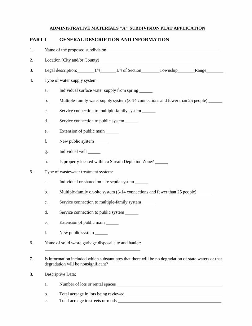
ADMINISTRATIVE MATERIALS "A" SUBDIVISION PLAT APPLICATION
PART I GENERAL DESCRIPTION AND INFORMATION
1. Name of the proposed subdivision
2. Location (City and/or County)
3. Legal description: 1/4 1/4 of Section Township Range
4. Type of water supply system:
a. Individual surface water supply from spring
b. Multiple-family water supply system (3-14 connections and fewer than 25 people)
c. Service connection to multiple-family system
d. Service connection to public system
e. Extension of public main
f. New public system
g. Individual well
h. Is property located within a Stream Depletion Zone?
5. Type of wastewater treatment system:
a. Individual or shared on-site septic system
b. Multiple-family on-site system (3-14 connections and fewer than 25 people)
c. Service connection to multiple-family system
d. Service connection to public system
e. Extension of public main
f. New public system
6. Name of solid waste garbage disposal site and hauler:
7. Is information included which substantiates that there will be no degradation of state waters or that
degradation will be nonsignificant?
8. Descriptive Data:
a. Number of lots or rental spaces
b. Total acreage in lots being reviewed
c. Total acreage in streets or roads

d. Total acreage in parks, open space, and/or common facilities
e. TOTAL gross acreage of subdivision
f. Minimum size of lots or spaces
g. Maximum size of lots or spaces
9. Indicate the proposed use(s) and number of lots or spaces in each:
Residential, single family
Residential, multiple family
Types of multiple family structures and numbers of each (e.g. duplex)
Planned Unit Development (Number of units )
Condominium (Number of units )
Mobile Home Subdivision (Number of spaces )
Recreational Vehicle Subdivision (Number of spaces )
Commercial or Industrial
Other (please describe)
10. Provide the following information regarding the development:
a. Current land use
b. Existing zoning or other regulations
c. Depth to ground water at the time of year when water table is nearest to the natural
ground surface within the drainfield area
d. Depth to bedrock or other impervious material in the drainfield area
e. If a tract of land is to be subdivided in phases, an overall development plan indicating the
intent for the development of phases within the preliminary plat approval of one to three
years.
f. Drafts of any covenants and restrictions to be included in deeds or contracts for sale.
Drafts of homeowners’ association bylaws and articles of incorporation, if applicable.
(Submitting a draft copy of a homeowners’ association bylaws and articles of
incorporation is adequate for DEQ to initiate and complete its review of sanitary
facilities, but a copy of the fully executed documents must be submitted before DEQ can
issue final approval.)
g. Indicate whether the mineral rights have been severed from the property:
Yes No
h. Indicate whether water rights have been severed from the property:
Yes No
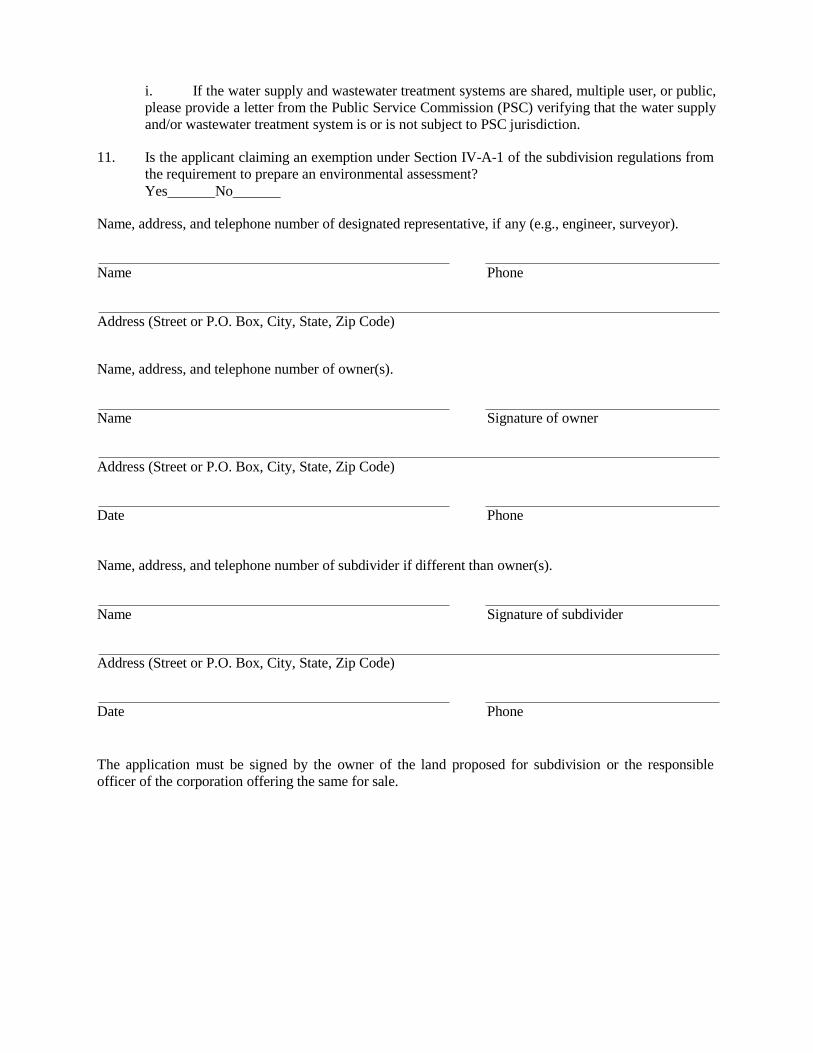
i. If the water supply and wastewater treatment systems are shared, multiple user, or public,
please provide a letter from the Public Service Commission (PSC) verifying that the water supply
and/or wastewater treatment system is or is not subject to PSC jurisdiction.
11. Is the applicant claiming an exemption under Section IV-A-1 of the subdivision regulations from
the requirement to prepare an environmental assessment?
Yes No
Name, address, and telephone number of designated representative, if any (e.g., engineer, surveyor).
Name Phone
Address (Street or P.O. Box, City, State, Zip Code)
Name, address, and telephone number of owner(s).
Name Signature of owner
Address (Street or P.O. Box, City, State, Zip Code)
Date Phone
Name, address, and telephone number of subdivider if different than owner(s).
Name Signature of subdivider
Address (Street or P.O. Box, City, State, Zip Code)
Date Phone
The application must be signed by the owner of the land proposed for subdivision or the responsible
officer of the corporation offering the same for sale.
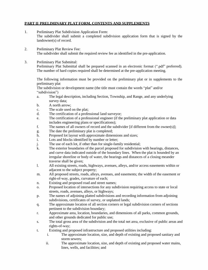
PART II PRELIMINARY PLAT FORM, CONTENTS AND SUPPLEMENTS
1. Preliminary Plat Subdivision Application Form: The subdivider shall submit a completed subdivision application form that is signed by the
landowner(s) of record.
2. Preliminary Plat Review Fee:
The subdivider shall submit the required review fee as identified in the pre-application.
3. Preliminary Plat Submittal: Preliminary Plat Submittal shall be prepared scanned in an electronic format (“.pdf” preferred).
The number of hard copies required shall be determined at the pre-application meeting.
The following information must be provided on the preliminary plat or in supplements to the
preliminary plat
The subdivision or development name (the title must contain the words “plat” and/or
“subdivision”)
a. The legal description, including Section, Township, and Range, and any underlying
survey data;
b. A north arrow;
c. The scale used on the plat;
d. The certification of a professional land surveyor;
e. The certification of a professional engineer (if the preliminary plat application or data
includes engineering plans or specifications);
f. The names of all owners of record and the subdivider [if different from the owner(s)];
g. The date the preliminary plat is completed;
h. Proposed lot layout with approximate dimensions and sizes;
i. Lots and blocks identified by number or letter;
j. The use of each lot, if other than for single-family residential;
k. The exterior boundaries of the parcel proposed for subdivision with bearings, distances,
and curve data indicated outside of the boundary lines. When the plat is bounded by an
irregular shoreline or body of water, the bearings and distances of a closing meander
traverse shall be given;
l. All existing streets, roads, highways, avenues, alleys, and/or access easements within or
adjacent to the subject property;
m. All proposed streets, roads, alleys, avenues, and easements; the width of the easement or
right-of-way, grades, curvature of each;
n. Existing and proposed road and street names; o. Proposed location of intersections for any subdivision requiring access to state or local
streets, roads, avenues, alleys, or highways;
p. The names of adjoining platted subdivisions and recording information from adjoining
subdivisions, certificates of survey, or unplatted lands;
q. The approximate location of all section corners or legal subdivision corners of sections
pertinent to the subdivision boundary;
r. Approximate area, location, boundaries, and dimensions of all parks, common grounds,
and other grounds dedicated for public use;
s. The total gross area of the subdivision and the total net area, exclusive of public areas and
rights-of-way;
t. Existing and proposed infrastructure and proposed utilities including: i. The approximate location, size, and depth of existing and proposed sanitary and
storm sewers;
ii. The approximate location, size, and depth of existing and proposed water mains,
lines, wells, and facilities; and
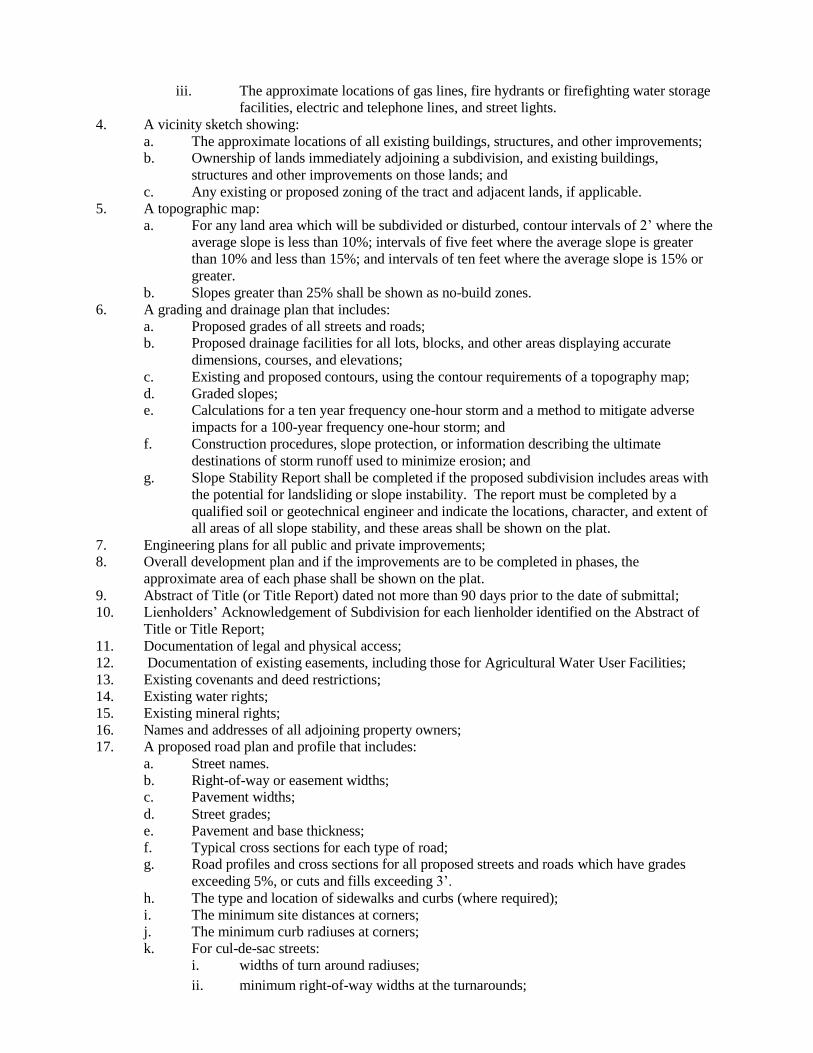
iii. The approximate locations of gas lines, fire hydrants or firefighting water storage
facilities, electric and telephone lines, and street lights.
4. A vicinity sketch showing:
a. The approximate locations of all existing buildings, structures, and other improvements; b. Ownership of lands immediately adjoining a subdivision, and existing buildings,
structures and other improvements on those lands; and
c. Any existing or proposed zoning of the tract and adjacent lands, if applicable.
5. A topographic map:
a. For any land area which will be subdivided or disturbed, contour intervals of 2’ where the
average slope is less than 10%; intervals of five feet where the average slope is greater
than 10% and less than 15%; and intervals of ten feet where the average slope is 15% or
greater.
b. Slopes greater than 25% shall be shown as no-build zones.
6. A grading and drainage plan that includes:
a. Proposed grades of all streets and roads; b. Proposed drainage facilities for all lots, blocks, and other areas displaying accurate
dimensions, courses, and elevations;
c. Existing and proposed contours, using the contour requirements of a topography map;
d. Graded slopes; e. Calculations for a ten year frequency one-hour storm and a method to mitigate adverse
impacts for a 100-year frequency one-hour storm; and
f. Construction procedures, slope protection, or information describing the ultimate
destinations of storm runoff used to minimize erosion; and
g. Slope Stability Report shall be completed if the proposed subdivision includes areas with
the potential for landsliding or slope instability. The report must be completed by a
qualified soil or geotechnical engineer and indicate the locations, character, and extent of
all areas of all slope stability, and these areas shall be shown on the plat.
7. Engineering plans for all public and private improvements; 8. Overall development plan and if the improvements are to be completed in phases, the
approximate area of each phase shall be shown on the plat.
9. Abstract of Title (or Title Report) dated not more than 90 days prior to the date of submittal; 10. Lienholders’ Acknowledgement of Subdivision for each lienholder identified on the Abstract of
Title or Title Report;
11. Documentation of legal and physical access;
12. Documentation of existing easements, including those for Agricultural Water User Facilities;
13. Existing covenants and deed restrictions;
14. Existing water rights;
15. Existing mineral rights;
16. Names and addresses of all adjoining property owners;
17. A proposed road plan and profile that includes:
a. Street names.
b. Right-of-way or easement widths; c. Pavement widths;
d. Street grades;
e. Pavement and base thickness;
f. Typical cross sections for each type of road; g. Road profiles and cross sections for all proposed streets and roads which have grades
exceeding 5%, or cuts and fills exceeding 3’.
h. The type and location of sidewalks and curbs (where required);
i. The minimum site distances at corners;
j. The minimum curb radiuses at corners;
k. For cul-de-sac streets:
i. widths of turn around radiuses;
ii. minimum right-of-way widths at the turnarounds;
iii. minimum pavement or road surface width at the turnarounds; iv. total lengths of the streets.
l. The locations and characteristics of bridges and culverts;
m. The locations and dimensions of adjoining lots and open spaces; n. The locations and widths of easements and dedicated land, which provide a buffer
between the subdivision lots and streets;
o. Typical grading and location of intersections with private driveways; and
p. Description of how the roads will be maintained.
18. Approach/access/encroachment permits from Montana Department of Transportation or the local
jurisdiction;
19. Proposed easements;
20. Proposed disposition of water rights, as required by Section VI-O of the subdivision regulations;
21. Proposed disposition of mineral rights;
22. Parkland dedication calculations, including a property valuation assessment or appraisal if cash-
in-lieu of parkland is proposed;
23. Environmental Assessment and/or Summary of Probable Impacts including: a. proof that the subdivider has submitted for review copies of the subdivision application
and environmental assessment, if applicable, to the public utilities and agencies of the
local, state, and federal government identified during the pre-application meeting or
subsequently identified as having an interest in the proposed subdivision; and
b. an explanation of how the subdivider has responded to the comments of the subdivision
administrator at the pre-application meeting.
24. Transportation Impact Analysis or Transportation Plan; 25. Fire Risk Rating Analysis and Fire Prevention Plan as required in Section VI-R of the subdivision
regulations;
26. Weed Management Plan and Re-vegetation Plan; 27. Property owners’ Association Documents shall accompany the preliminary plat, and at a
minimum shall provide the information, form, and contents included in Section II-B-3 of the
subdivision regulations;
28. FIRM or FEMA panel map and/or letter identifying floodplain status and other hydrologic
characteristics including surface water bodies, designated floodplain and areas of riparian
resource, as required in Section VI-D of the subdivision regulations and paragraph 35 of this Part
II.
29. Required water and sanitation information, including:
a. Provide the following attachments to the preliminary plat:
i. A vicinity map or plan that shows: A. The location, within 100 feet outside of the exterior of the property line
of the subdivision and on the proposed lots, of:
1. floodplains;
2. surface water features; 3. springs;
4. irrigation ditches; 5. existing, previously approved, and for parcels less than 20 acres,
proposed water wells and wastewater treatment systems;
6. for parcels less than 20 acres, mixing zones identified as
provided in subsection (X); and
7. the representative drain field site used for the soil profile
description as required under subsection (C)(4); and
B. The location, within 500 feet outside of the exterior property line of the
subdivision, of public water and sewer facilities.
ii. A description of the proposed subdivision’s water supply systems, storm water
systems, solid waste disposal systems, and wastewater treatment systems, as
provided below, including whether the water supply and wastewater treatment
systems are individual, shared, multiple user, or public as those systems are
defined in rule published by the DEQ;
iii. A drawing of the conceptual lot layout at a scale no smaller than 1 inch equal to 200
feet that shows all information required for a lot layout document in rules adopted
by DEQ pursuant to 76-4-104;
b. Water Supply i. High Groundwater Report indicating there is not a problem with high groundwater
present on the property proposed for subdivision. When evidence of high
groundwater is present, the developer must submit plans that are prepared by a
professional engineer to mitigate the problem;
ii. A vicinity map or plan that shows:
A. the location, within 100’ outside of the exterior property line of the
subdivision and on the proposed lots of:
1. floodplains;
2. surface water features;
3. springs;
4. irrigation ditches; 5. existing, previously approved, and, for parcels less than 20 acres,
proposed water wells and wastewater treatment systems;
6. for parcels less than 20 acres, mixing zones identified as
provided in subsection c.i.C.1 below.
B. the location, within 500’ outside the exterior property line of the
subdivision, of public water and sewer facilities;
iii. A description of the proposed subdivision’s water supply systems, storm water
systems, solid waste disposal systems, and wastewater treatment systems, including a
statement as to whether the water/wastewater systems are subject to Public Service
Commission jurisdiction and if not, why they are exempt; whether the water supply
and wastewater treatment systems are individual, shared, multiple user, or public as
those systems are defined in rules published by the Department of Environmental
Quality in the Administrative Rules of Montana, or 76-4-101 et seq., MCA, including
the following information:
A. If an individual water supply system is proposed for each parcel:
1. Indicate the distance to the nearest public water system. 2. Attach a copy of the lot layout showing the proposed location of
each spring, well, or cistern and indicating the distance to existing or
proposed wastewater treatment systems.
3. Evidence of sufficient water quality in accordance with rules
adopted by the DEQ pursuant to 76-4-104;
B. For a multiple user water system:
1. If an existing system is to be used: a. identify the system and the person, firm, or agency
responsible for its operation and maintenance;
b. indicate the system’s capacity to handle additional load and its
distance from the development;
c. provide evidence that permission to connect to the system has
been granted;
2. provide the following attachments:
a. map or plat showing location, sizes, and depth of any existing
water supply lines and facilities which may directly serve
parcels within the proposed development;
b. provide plans and specifications for all proposed extensions and
additional lines and facilities as required by ARM
17.38.305 and Circular DEQ 3.

3. evidence of sufficient water quality in accordance with rules
adopted by the DEQ pursuant to 76-4-104;
v. Where a new system is proposed: A. Provide evidence of adequate water availability, unless cisterns are
proposed:
1. obtained from well logs or testing of onsite or nearby wells; 2. obtained from information contained in published
hydrogeological reports; or
3. as otherwise specified by rules adopted by the DEQ pursuant to 76-
4-104;
B. indicate who will install the system, who will bear the costs, when it will be
completed, and who will own it;
C. provide all information required in ARM 17.36.330-336 and Circular
DEQ-3.
D. Evidence of sufficient water quality in accordance with rule adopted by the
DEQ pursuant to 76-4-104;
C. For a public water system:
1. If an existing system is to be used: a. identify the system and the person, firm, or agency
responsible for its operation and maintenance;
b. indicate the system’s capacity to handle additional load and its
distance from the development;
c. provide evidence that permission to connect has been
granted;
d. provide the following as attachments: i. a map or plat showing the location, sizes, and depth of any
existing water lines and facilities which will directly serve
parcels within the proposed development;
ii. plans and specifications for all proposed extensions and
additional lines and facilities as required by ARM
17.36.328-330 and Circular DEQ-1 or Circular DEQ-3.
iii. Evidence of sufficient water quality in accordance with rule
adopted by the DEQ pursuant to 76-4-104;
2. If a new system is proposed:
a. Provide evidence of adequate water availability: i. obtained from well logs or testing of onsite or nearby
wells;
ii. obtained from information contained in published
hydrogeological reports; or
iii. as otherwise specified by rules adopted by the DEQ
pursuant to 76-4-104;
b. indicate who will install the system, who will bear the costs,
when it will be completed, and who will own it;
provide plans and specifications for all proposed extensions and
additional lines and facilities as required by ARM 17.36.328-330
and Circular DEQ-1 or Circular DEQ-3.
Evidence of sufficient water quality in accordance with rules
adopted by the DEQ pursuant to 76-4-104;
c. Wastewater Treatment System i. For new onsite wastewater treatment systems, evidence of suitability that at a
minimum includes:
A. a soil profile description from a representative drainfield site identified on
the vicinity map, as provided in section C.1.(a)(i)(G), that complies with
the standards published by DEQ;

B. demonstration that the soil profile contains a minimum of 4 feet of vertical
separation distance between the bottom of the permeable surface of the
proposed wastewater treatment system and a limiting layer; and
C. in cases in which the soil profile or other information indicates that ground
water is within 7 feet of the natural ground surface, evidence that the ground
water will not exceed the minimum vertical separation distance provided in
section (ii) above.
1. For all new wastewater treatment systems a preliminary analysis of
potential impacts to ground water quality using as guidance rules
adopted by the board of environmental review pursuant to 75-5-301
and 75-5-303 related to standard mixing zones for ground water,
source specific mixing zones, and nonsignificant changes in water
quality. The preliminary analysis may be based on currently
available information and must consider the effects of overlapping
mixing zones from proposed and existing wastewater treatment
systems within and directly adjacent to the subdivision. Instead of
performing the preliminary analysis required under this subsection
the subdivider may perform a complete nondegradation analysis in
the same manner as is required for an application that is reviewed
under Title 76, chapter 4.
ii. If individual wastewater treatment systems are proposed for each parcel:
A. Indicate the distance to the nearest public wastewater treatment system. B. Provide all information required in ARM 17.36.320-345 and in Circular
DEQ-4 for conventional systems or Circular DEQ 5 for alternative systems.
C. evidence of suitability as provided in subsection (a) of this section D. preliminary analysis of potential impact to ground water as provided in
subsection (b) of this section.
iii. For a multiple-user wastewater treatment system:
A. If an existing system is to be used: 1. identify the system and the person, firm, or agency responsible for
its operation and maintenance;
2. indicate the system’s capacity to handle additional load and its
distance from the development;
3. provide evidence that permission to connect to the system has
been granted;
4. provide the following attachments: a. a map or plat showing the location, sizes, and depth of any
existing sewer lines and facilities which will directly serve
parcels within the proposed development; and
plans and specifications for all proposed extensions and
additional lines and facilities as required by ARM
17.36.320-345 and Circular DEQ-4 or Circular DEQ-5.
B. If a new system is proposed:
1. indicate who will install the system, who will bear the costs,
when it will be completed, and who will own it;
2. provide all information required in ARM 17.36.320-326 and
Circular DEQ-4 or Circular DEQ-5.
3. evidence of suitability as provided in subsection (a) of this
section.
4. preliminary analysis of potential impact to ground water as
provided in subsection (b) of this section.
5.
iv. For a public wastewater treatment system:
A. If an existing system is to be used:

1. identify the system and the person, firm, or agency responsible
for its operation and maintenance;
2. indicate the system’s capacity to handle additional load and its
distance from the development;
3. provide evidence that permission to connect to the system has
been granted;
4. provide the following attachments: a. a map or plat showing the location, sizes, and depth of any
existing sewer lines and facilities which will directly serve
parcels within the proposed development;
b. plans and specifications for all proposed extensions and
additional lines and facilities as required by ARM 17.36.328
and Circular DEQ-2 or Circular DEQ-4.
d. Storm Water i. Describe measures for the collection and disposal of storm run-off from streets
and roads within the subdivision.
ii. Indicate the type of road surface proposed.
iii. Describe facilities for stream or drainage crossing (e.g., culverts, bridges).
iv. Describe how surface run-off will be drained or channeled from parcels.
iv. Indicate whether storm run-off will enter state waters and describe any proposed
treatment measures. (A storm-water discharge permit may be required)
iv. Describe any existing or proposed streambank or shoreline alteration, and any
proposed construction or modification of lake beds or stream channels. Provide
information on location, extent, type, and purpose of alteration.
iv. Provide the grading and storm water or drainage plan as required by section II-3
Preliminary Plat Supplements, subsection (e) of this appendix.
e. Solid Waste
i. Describe the proposed method of solid waste collection and disposal. ii. If use of an existing collection system or disposal facility is proposed, indicate
the name and location of the facility.
iii. If on-site disposal of solid waste is proposed, provide the information required in
ARM 17.36.309(2).
30. A form of Subdivision Improvements Agreement, if proposed;
31. Letter requesting a revocation of agricultural covenants;
32. Letter indicating locations of cultural or historic resources;
33. Variance request or approval;
34. Re-zoning application or approval; 35. When required, a flood hazard evaluation which contains the following detailed information:[to
be submitted to the Water Resources Division, Department of Natural Resources]:
a. Certification by a registered professional engineer;
b. An overall scaled plan view with identified scale for vertical and horizontal distance
showing the following:
i. Watercourse
ii. floodplain boundaries
iii. location of property
iv. contours
v. cross-sections
vi. bridges or other contractions in the floodplains
vii. USGS gauging stations (if any); c. The location and elevation of a temporary benchmark(s) established within the
subdivision and referenced to mean sea level with appropriate elevation adjustment.
d. Cross-sectional information which contains the following information: i. Elevations and stations that are determined at points representing significant
breaks in ground slope and at changes in the hydraulic characteristics of the
floodplain (i.e., points where ground cover, soil, or rock conditions change).
Elevations must be reported in NAVD 88 or NGVD 29 datum.
ii. Each cross-section must cross the entire floodplain. The cross-section alignment
should be perpendicular to the general flow of the watercourse (approximately
perpendicular to contour lines). Occasionally, wide floodplains require a dog-leg
alignment to be perpendicular to the anticipated flow lines. Shots should be
taken at the water’s edge and measurements taken (if elevation shots cannot be
taken) to determine the channel bottom shape. Cross sections must be accurately
located on a USGS 7 ½ minute quad sheet.
iii. The number of cross-sections needed, and the distance between cross-sections,
will vary depending on the site, the slope of the watercourse, the slope of the
channel, and the hydraulic characteristics of the reach. A minimum of four cross
sections are required over the entire reach with at least two cross-sections at the
property where the elevations are desired. Additional cross-sections must be
taken at bridges, control structures, or natural constrictions in topography.
[Photogrammetric methods may be used in lieu of cross sections whenever
appropriate and when reviewed and approved by the county.]
e. A description and sketch of all bridges within the reach, showing unobstructed waterway
openings and elevations.
f. Elevation of the water surface is to be determined by survey as part of each valley cross
section.
g. Supporting Documentation, such as engineering reports of computer computations,
calculations, and assumptions that may include:
i. Hydrology (research of published hydrology or calculations showing how
hydrology was derived)
ii. Input files (hardcopy and on diskette)
iii. Output files (diskette only) 36. Letter identifying and proposing mitigation for potential hazards or other adverse impacts as
identified in the pre-application meeting and not covered by any of the above required materials;
and
37. Such additional relevant and reasonable information as identified by the Subdivision
Administrator during the pre-application meeting that is pertinent to the required elements of this
section.
PART III ENVIRONMENTAL ASSESSMENT*
Information specified in this Part must be provided in addition to that required in parts I and II of this
application form, unless the proposed subdivision qualifies for an exemption under Section IV-A-1.b of
the subdivision regulations.
Describe the following environmental features, provide responses to each of the following questions and
provide reference materials as required.
1. Surface Water
Locate on a plat overlay or sketch map:
a. Any natural water systems such as streams, rivers, intermittent streams, lakes or marshes
(also indicate the names and sizes of each).
b. Any artificial water systems such as canals, ditches, aqueducts, reservoirs, and irrigation
systems (also indicate the names, sizes and present uses of each).
c. Time when water is present (seasonally or all year).
d. Any areas subject to flood hazard, or in delineated 100 year floodplain.
e. Describe any existing or proposed streambank alteration from any proposed construction
or modification of lake beds or stream channels. Provide information on location, extent,
type and purpose of alteration, and permits applied for.
2. Groundwater
Using available data, provide the following information:
a. The minimum depth to water table and identify dates when depths were determined.
What is the location and depth of all aquifers which may be affected by the proposed
subdivision? Describe the location of known aquifer recharge areas which may be
affected.
b. Describe any steps necessary to avoid depletion or degradation of groundwater recharge
areas.
3. Topography, Geology and Soils
a. Provide a map of the topography of the area to be subdivided, and an evaluation of
suitability for the proposed land uses. On the map identify any areas with highly erodible
soils or slopes in excess of 15% grade. Identify the lots or areas affected. Address
conditions such as:
i Shallow bedrock
ii Unstable slopes iii Unstable or expansive soils
iv Excessive slope
b. Locate on an overlay or sketch map: i Any known hazards affecting the development which could result in property
damage or personal injury due to:
A. Falls, slides or slumps -- soil, rock, mud, snow.
B. Rock outcroppings
C. Seismic activity.
D. High water table
c. Describe measures proposed to prevent or reduce these dangers.
d. Describe the location and amount of any cut or fill more than three feet in depth. Indicate
these cuts or fills on a plat overlay or sketch map. Where cuts or fills are necessary,
describe plans to prevent erosion and to promote vegetation such as replacement of
topsoil and grading.
4. Vegetation
a. On a plat overlay or sketch map:
(i) Indicate the distribution of the major vegetation types, such as marsh, grassland,
shrub, coniferous forest, deciduous forest, mixed forest.
(ii) Identify the location of critical plant communities such as:
A. Stream bank or shoreline vegetation
B. Vegetation on steep, unstable slopes
C. Vegetation on soils highly susceptible to wind or water erosion D. Type and extent of noxious weeds
b. Describe measures to:
(i) Preserve trees and other natural vegetation (e.g. locating roads and lot
boundaries, planning construction to avoid damaging tree cover).
(ii) Protect critical plant communities (e.g. keeping structural development away
from these areas), setting areas aside for open space.
(iii) Prevent and control grass, brush or forest fires (e.g. green strips, water supply,
access.)
(iv) Control and prevent growth of noxious weeds
5. Wildlife
a. Identify species of fish and wildlife use the area affected by the proposed subdivision.
b. On a copy of the preliminary plat or overlay, identify known critical wildlife areas, such
as big game winter range, calving areas and migration routes; riparian habitat and
waterfowl nesting areas; habitat for rare or endangered species and wetlands.
c. Describe proposed measures to protect or enhance wildlife habitat or to minimize
degradation (e.g. keeping buildings and roads back from shorelines; setting aside
wetlands as undeveloped open space).

PART IV SUMMARY OF PROBABLE IMPACTS
Summarize the effects of the proposed subdivision on each topic below. Provide responses to the
following questions and provide reference materials as required:
1. Effects on Agriculture
a. Is the proposed subdivision or associated improvements located on or near prime
farmland or farmland of statewide importance as defined by the Natural Resource
Conservation Service? If so, identify each area on a copy of the preliminary plat.
b. Describe whether the subdivision would remove from production any agricultural or
timber land.
c. Describe possible conflicts with nearby agricultural operations (e.g., residential
development creating problems for moving livestock, operating farm machinery,
maintaining water supplies, controlling weeds or applying pesticides; agricultural
operations suffering from vandalism, uncontrolled pets or damaged fences).
d. Describe possible nuisance problems which may arise from locating a subdivision near
agricultural or timber lands.
e. Describe effects the subdivision would have on the value of nearby agricultural lands.
2. Effects on Agricultural Water User Facilities
a. Describe conflicts the subdivision would create with agricultural water user facilities (e.g.
residential development creating problems for operating and maintaining irrigation
systems) and whether agricultural water user facilities would be more subject to
vandalism or damage because of the subdivision.
b. Describe possible nuisance problems which the subdivision would generate with regard
to agricultural water user facilities (e.g. safety hazards to residents or water problems
from irrigation ditches, head gates, siphons, sprinkler systems, or other agricultural water
user facilities).
3. Effects on Local Services
a. Indicate the proposed use and number of lots or spaces in each:
Residential, single family
Residential, multiple family
Types of multiple family structures and number of each (e.g. duplex, 4-plex)
Planned unit development (No. of units)
Condominium (No. of units)
Mobile Home Park
Recreational Vehicle Park
Commercial or Industrial Other (Please describe )
b. Describe the additional or expanded public services and facilities that would be
demanded of local government or special districts to serve the subdivision.
i. Describe additional costs which would result for services such as roads, bridges,
law enforcement, parks and recreation, fire protection, water, sewer and solid
waste systems, schools or busing, (including additional personnel, construction,
and maintenance costs).
ii. Who would bear these costs (e.g. all taxpayers within the jurisdiction, people
within special taxing districts, or users of a service)?
iii. Can the service providers meet the additional costs given legal or other
constraints (e.g. statutory ceilings on mill levies or bonded indebtedness)?
iv. Describe off-site costs or costs to other jurisdictions may be incurred (e.g.
development of water sources or construction of a sewage treatment plant; costs
borne by a nearby municipality).
c. Describe how the subdivision allows existing services, through expanded use, to operate
more efficiently, or makes the installation or improvement of services feasible (e.g. allow
installation of a central water system, or upgrading a country road).
d. What are the present tax revenues received from the unsubdivided land?
i. By the County $
ii. By the municipality if applicable iii. By the school(s) $
e. Provide the approximate revenues received by each above taxing authority if the lots are
reclassified, and when the lots are all improved and built upon. Describe any other taxes
that would be paid by the subdivision and into what funds (e.g. personal property taxes
on mobile/manufactured homes are paid into the County general fund).
f. Would new taxes generated from the subdivision cover additional public costs?
g. How many special improvement districts would be created which would obligate local
government fiscally or administratively? Are any boding plans proposed which would
affect the local government's bonded indebtedness?
4. Effects on the Historic or Natural Environment
a. Describe and locate on a plat overlay or sketch map known or possible historic,
paleontological, archaeological or cultural sites, structures, or objects which may be
affected by the proposed subdivision.
b. How would the subdivision affect surface and groundwater, soils, slopes, vegetation,
historical or archaeological features within the subdivision or on adjacent land? Describe
plans to protect these sites.
i Would any streambanks or lake shorelines be altered, streams rechanneled or any
surface water contaminated from sewage treatment systems, run-off carrying
sedimentation, or concentration of pesticides or fertilizers?
ii Would groundwater supplies likely be contaminated or depleted as a result of the
subdivision?
iii Would construction of roads or building sites require cuts and fills on steep
slopes or cause erosion on unstable, erodible soils? Would soils be contaminated
by sewage treatment systems?
iv Describe the impacts that removal of vegetation would have on soil erosion,
bank, or shoreline instability.
v Would the value of significant historical, visual, or open space features be
reduced or eliminated?
vi Describe possible natural hazards the subdivision be could be subject to (e.g.,
natural hazards such as flooding, rock, snow or landslides, high winds, severe
wildfires, or difficulties such as shallow bedrock, high water table, unstable or
expansive soils, or excessive slopes).
c. How would the subdivision affect visual features within the subdivision or on adjacent
land? Describe efforts to visually blend the proposed development with the existing
environment (e.g. use of appropriate building materials, colors, road design, underground
utilities, and revegetation of earthworks).
5. Effects on Wildlife
a. Describe what impacts the subdivision or associated improvements would have on
wildlife areas such as big game wintering range, migration routes, nesting areas,
wetlands, or important habitat for rare or endangered species.
b. Describe the effect that pets or human activity would have on wildlife.
6. Effects on Wildlife Habitat
a. Describe what impacts the subdivision or associated improvements would have on
wildlife areas such as big game wintering range, migration routes, nesting areas,
wetlands, or important habitat for rare or endangered species.
b. Describe the effect that pets or human activity would have on wildlife habitat.
7. Effects on the Public Health and Safety
a. Describe any health or safety hazards on or near the subdivision, such as: natural hazards,
lack of water, drainage problems, heavy traffic, dilapidated structures, high pressure gas
lines, high voltage power lines, or irrigation ditches. These conditions, proposed or
existing should be accurately described with their origin and location identified on a copy
of the preliminary plat.
b. Describe how the subdivision would be subject to hazardous conditions due to high
voltage lines, airports, highways, railroads, dilapidated structures, high pressure gas lines,
irrigation ditches, and adjacent industrial or mining uses.
c. Describe land uses adjacent to the subdivision and how the subdivision will affect the
adjacent land uses. Identify existing uses such as feed lots, processing plants, airports or
industrial firms which could be subject to lawsuits or complaints from residents of the
subdivision.
d. Describe public health or safety hazards, such as dangerous traffic, fire conditions, or
contamination of water supplies which would be created by the subdivision.

PART V COMMUNITY IMPACT REPORT
Provide a community impact report containing a statement of estimated number of people coming into the
area as a result of the subdivision, anticipated needs of the proposed subdivision for public facilities and
services, the increased capital and operating cost to each affected unit of local government. Provide
responses to each of the following questions and provide reference materials as required.
1. Education and Busing
a. Describe the available educational facilities which would serve this subdivision.
b. Estimate the number of school children that will be added by the proposed subdivision.
Provide a statement from the administrator of the affected school system indicating
whether the increased enrollment can be accommodated by the present personnel and
facilities and by the existing school bus system. If not, estimate the increased
expenditures that would be necessary to do so.
2. Roads and Maintenance
a. Estimate how much daily traffic the subdivision, when fully occupied, will generate on
existing streets and arterials.
b. Describe the capability of existing and proposed roads to safely accommodate this
increased traffic.
c. Describe increased maintenance problems and increased cost due to this increase in
volume.
d. Describe proposed new public or private access roads including:
i. Measures for disposing of storm run-off from streets and roads.
ii. Type of road surface and provisions to be made for dust.
iii. Facilities for streams or drainage crossing (e.g. culverts, bridges).
iv. Seeding of disturbed areas.
e. Describe the closing or modification of any existing roads.
f. Explain why road access was not provided within the subdivision, if access to any
individual lot is directly from arterial streets or roads.
g. Is year-round access by conventional automobile over legal rights-of-way available to the
subdivision and to all lots and common facilities within the subdivision? Identify the
owners of any private property over which access to the subdivision will be provided.
h. Estimate the cost and completion date of the system, and indicate who will pay the cost
of installation, maintenance and snow removal.
3. Water, Sewage, and Solid Waste Facilities
a. Briefly describe the water supply and sewage treatment systems to be used in serving the
proposed subdivision (e.g. methods, capacities, locations).

b. Provide information on estimated cost of the system, who will bear the costs, and how the
system will be financed.
c. Where hook-up to an existing system is proposed, describe estimated impacts on the
existing system, and show evidence that permission has been granted to hook up to the
existing system.
d. All water supply and sewage treatment plans and specifications will be reviewed and
approved by the Department of Environmental Quality (DEQ) and should be submitted
using the appropriate DEQ application form.
e. Describe the proposed method of collecting and disposing of solid waste from the
development.
f. If use of an existing collection system or disposal facility is proposed indicate the name
and location of the facility.
4. Fire and Police Protection
a. Describe the fire and police protection services available to the residents of the proposed
subdivision including number of personnel and number of vehicles or type of facilities for:
i Fire protection -- is the proposed subdivision in an existing fire district? If not,
will one be formed or extended? Describe what fire protection procedures are
planned?
ii Law -- Enforcement protection – Which of --is the proposed subdivision within
the jurisdiction of a County Sheriff or municipal policy department
b. Can the fire and police protection service needs of the proposed subdivision be met by
present personnel and facilities? If not, describe the additional expenses that would be
necessary to make these services adequate, and who would pay the costs?
5. Payment for extension of Capital Facilities
Indicate how the subdivider will pay for the cost of extending capital facilities resulting from
expected impacts directly attributable to the subdivision.

B-1
ADMINISTRATIVE MATERIALS “B” FINAL PLAT APPROVAL FORM
Date
1. Name of Subdivision
2. Location: 1/4 Section Township Range For
Amended Plats: Lot(s) Block(s) Subdivision
3. Name, address and telephone number of subdivider:
4. Name, address and telephone number of persons of firms providing services and information (e.g.: surveyor, engineer, designer, planning consultant, attorney):
5. Descriptive Data:
a. Gross area in acres
b. Number of lots or rental spaces
c. Existing zoning or other regulations
6. Date Preliminary Plat Approved:
7. Any Conditions? (If Yes, attach list of conditions.)
8. Any Deed Restrictions or covenants? (If Yes, attach a copy.)
9. All improvements installed?
agreement or guarantees.)
(If No, attach a subdivision improvements
10. List of materials submitted with this application:
a.
b. c.
d.
e. f.
B-2
I do hereby certify that all the statements and information and the statements and information contained in
all exhibits transmitted herewith are true. I hereby apply to the (governing body) of (city or county) for
approval of the final plat of (Name of Subdivision).
Subdivider
-----------------------------------------------------------------
FOR OFFICIAL USE ONLY
1. Application Number
2. Date Application Submitted
3. Date by which Final Plat must be approved or rejected

C-1
ADMINISTRATIVE MATERIALS “C” SAMPLE CERTIFICATES
Certificate of Completion of Public Improvements
Certificate of Surveyor – Final Plat
Certificate of Dedication – Final Plat
Certificate of Consent to Dedication by Encumbrances
Certificate of Waiver of Park Land Dedication and Acceptance of Cash in Lieu Thereof
Certificate of Examining Land Surveyor Where Required – Final Plat
Certificate of County Treasurer
Certificate of Final Plat Approval – County
Certificate of Final Plat Approval – City
Certificate of Filing by Clerk and Recorder

C-2
Certificate of Completion of Public Improvements Agreement
(To be submitted with application for approval of final subdivision plat)
CERTIFICATE OF COMPLETION
I, (Name of Subdivider), and I, (Name of Subdivider’s Registered Engineer ), a registered professional
engineer licensed to practice in the State of Montana, hereby certify that the following public
improvements, required as a condition of approval of (Name of Subdivision), have been installed in
conformance with the attached engineering specifications and plans: (List the improvements actually
installed.)
Signature of Subdivider Date
Signature of Professional Engineer Date
Registration No.
Address
(Engineers Seal)
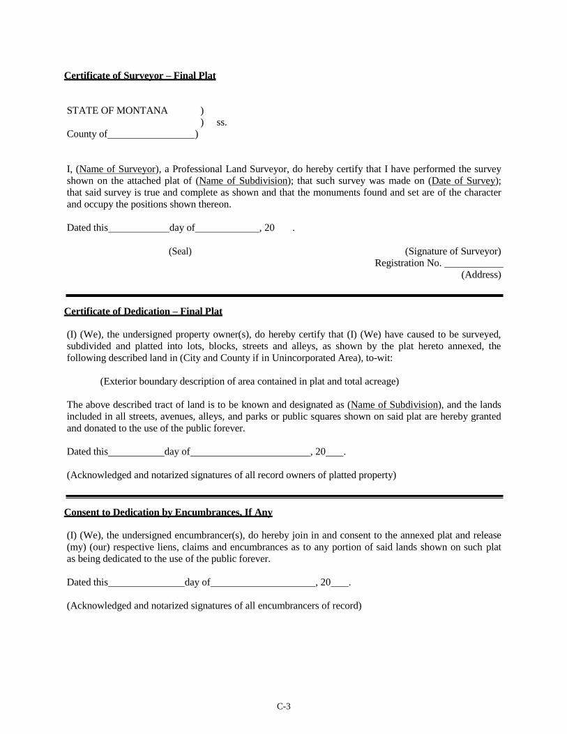
C-3
Certificate of Surveyor – Final Plat
STATE OF MONTANA )
) ss.
County of )
I, (Name of Surveyor), a Professional Land Surveyor, do hereby certify that I have performed the survey
shown on the attached plat of (Name of Subdivision); that such survey was made on (Date of Survey);
that said survey is true and complete as shown and that the monuments found and set are of the character
and occupy the positions shown thereon.
Dated this day of , 20 .
(Seal) (Signature of Surveyor)
Registration No.
(Address)
Certificate of Dedication – Final Plat
(I) (We), the undersigned property owner(s), do hereby certify that (I) (We) have caused to be surveyed,
subdivided and platted into lots, blocks, streets and alleys, as shown by the plat hereto annexed, the
following described land in (City and County if in Unincorporated Area), to-wit:
(Exterior boundary description of area contained in plat and total acreage)
The above described tract of land is to be known and designated as (Name of Subdivision), and the lands
included in all streets, avenues, alleys, and parks or public squares shown on said plat are hereby granted
and donated to the use of the public forever.
Dated this day of , 20 .
(Acknowledged and notarized signatures of all record owners of platted property)
Consent to Dedication by Encumbrances, If Any
(I) (We), the undersigned encumbrancer(s), do hereby join in and consent to the annexed plat and release
(my) (our) respective liens, claims and encumbrances as to any portion of said lands shown on such plat
as being dedicated to the use of the public forever.
Dated this day of , 20 .
(Acknowledged and notarized signatures of all encumbrancers of record)

C-4
Certificate of Waiver of Park Land Dedication and Acceptance of Cash in Lieu Thereof
I, (Name of City or Town Clerk), (County Clerk and Recorder) of (Name of City or County), Montana,
do certify that the following order was made by the (Governing Body) of (Name of City or County) at a
meeting thereof held on the day of _, 20 _, and entered into the
proceedings of said Body to-wit: “Inasmuch as the dedication of park land within the platted area of
(Name of Subdivision) is undesirable for the reasons set forth in the minutes of this meeting, it is hereby
ordered by the (Name of Governing Body) that land dedication for park purposes be waived and that cash
in lieu of park with the provisions of Title 76, Chapter 3, MCA.”
In witness whereof, I have hereunto affixed the seal of (Name of City or County), Montana this
day of , 20 _.
(Seal) (Signature of Clerk)
Certificate of Examining Land Surveyor Where Required – Final Plat
I, (Name of Examining Land Surveyor), acting as an Examining Land Surveyor for (City or County),
Montana, do hereby certify that I have examined the final plat of (Name of Subdivision) and find that the
survey data shown thereon meet the conditions set forth by or pursuant to Title 76, Chapter 3, Part 4,
MCA.
Dated this day of , 20 .
(Signature) (Name of Surveyor)
Registration No.
(City or County)
Certificate of County Treasurer
I hereby certify, pursuant to Section 76-3-611(1)(b), MCA, that all real property taxes assessed and levied
on the land described below and encompassed by the proposed (Name of Subdivision) have been paid:
(legal description of land)
Dated this day of , 20 .
(seal) (Signature of County Treasurer) Treasurer,
County, Montana
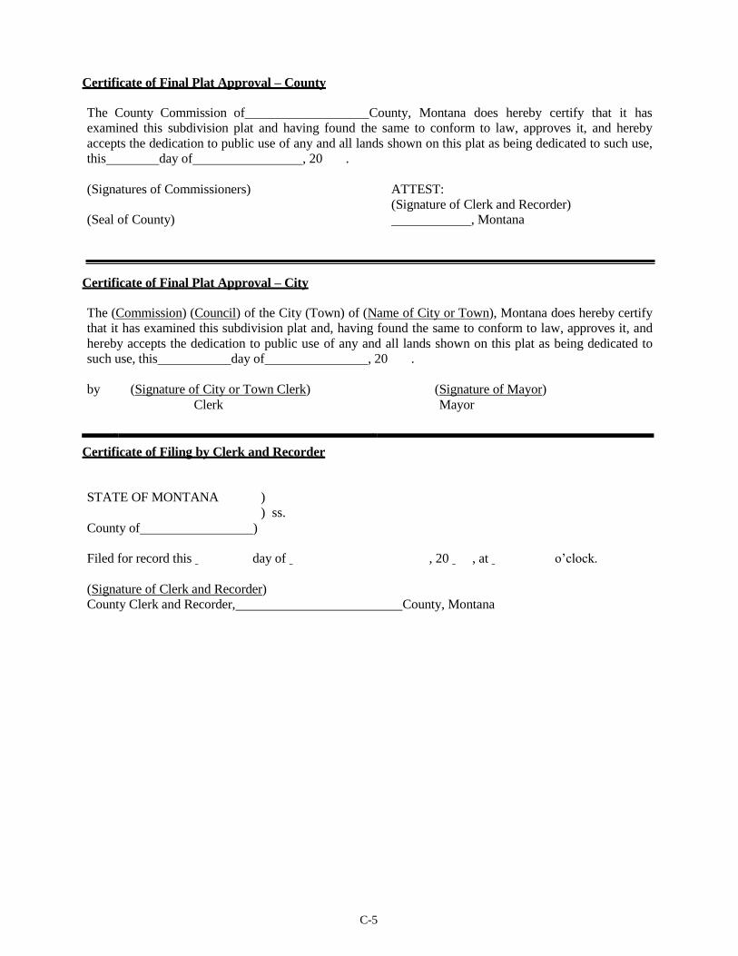
C-5
Certificate of Final Plat Approval – County
The County Commission of County, Montana does hereby certify that it has
examined this subdivision plat and having found the same to conform to law, approves it, and hereby
accepts the dedication to public use of any and all lands shown on this plat as being dedicated to such use,
this day of , 20 .
(Signatures of Commissioners) ATTEST:
(Signature of Clerk and Recorder) (Seal of County) , Montana
Certificate of Final Plat Approval – City
The (Commission) (Council) of the City (Town) of (Name of City or Town), Montana does hereby certify
that it has examined this subdivision plat and, having found the same to conform to law, approves it, and
hereby accepts the dedication to public use of any and all lands shown on this plat as being dedicated to
such use, this day of , 20 .
by (Signature of City or Town Clerk) (Signature of Mayor)
Clerk Mayor
Certificate of Filing by Clerk and Recorder
STATE OF MONTANA )
) ss.
County of )
Filed for record this day of , 20 , at o’clock.
(Signature of Clerk and Recorder)
County Clerk and Recorder, County, Montana
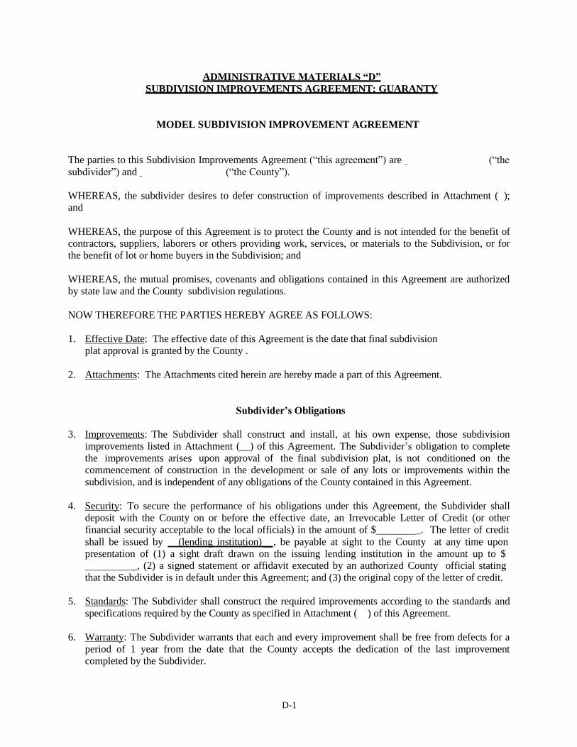
D-1
ADMINISTRATIVE MATERIALS “D”
SUBDIVISION IMPROVEMENTS AGREEMENT; GUARANTY
MODEL SUBDIVISION IMPROVEMENT AGREEMENT
The parties to this Subdivision Improvements Agreement (“this agreement”) are (“the
subdivider”) and (“the County”).
WHEREAS, the subdivider desires to defer construction of improvements described in Attachment ( );
and
WHEREAS, the purpose of this Agreement is to protect the County and is not intended for the benefit of
contractors, suppliers, laborers or others providing work, services, or materials to the Subdivision, or for
the benefit of lot or home buyers in the Subdivision; and
WHEREAS, the mutual promises, covenants and obligations contained in this Agreement are authorized
by state law and the County subdivision regulations.
NOW THEREFORE THE PARTIES HEREBY AGREE AS FOLLOWS:
1. Effective Date: The effective date of this Agreement is the date that final subdivision
plat approval is granted by the County .
2. Attachments: The Attachments cited herein are hereby made a part of this Agreement.
Subdivider’s Obligations
3. Improvements: The Subdivider shall construct and install, at his own expense, those subdivision
improvements listed in Attachment (__) of this Agreement. The Subdivider’s obligation to complete
the improvements arises upon approval of the final subdivision plat, is not conditioned on the
commencement of construction in the development or sale of any lots or improvements within the
subdivision, and is independent of any obligations of the County contained in this Agreement.
4. Security: To secure the performance of his obligations under this Agreement, the Subdivider shall
deposit with the County on or before the effective date, an Irrevocable Letter of Credit (or other
financial security acceptable to the local officials) in the amount of $ _. The letter of credit
shall be issued by (lending institution) , be payable at sight to the County at any time upon
presentation of (1) a sight draft drawn on the issuing lending institution in the amount up to $
_, (2) a signed statement or affidavit executed by an authorized County official stating
that the Subdivider is in default under this Agreement; and (3) the original copy of the letter of credit.
5. Standards: The Subdivider shall construct the required improvements according to the standards and
specifications required by the County as specified in Attachment ( ) of this Agreement.
6. Warranty: The Subdivider warrants that each and every improvement shall be free from defects for a
period of 1 year from the date that the County accepts the dedication of the last improvement
completed by the Subdivider.
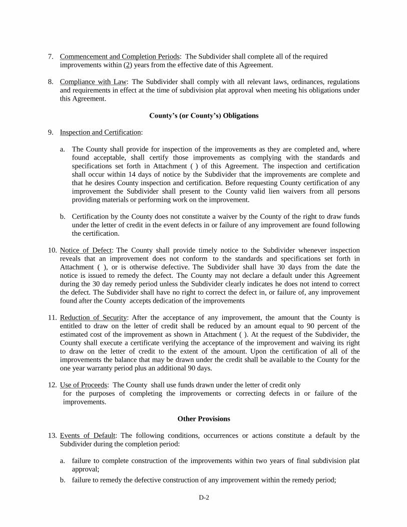
D-2
7. Commencement and Completion Periods: The Subdivider shall complete all of the required
improvements within (2) years from the effective date of this Agreement.
8. Compliance with Law: The Subdivider shall comply with all relevant laws, ordinances, regulations
and requirements in effect at the time of subdivision plat approval when meeting his obligations under
this Agreement.
County’s (or County’s) Obligations
9. Inspection and Certification:
a. The County shall provide for inspection of the improvements as they are completed and, where
found acceptable, shall certify those improvements as complying with the standards and
specifications set forth in Attachment ( ) of this Agreement. The inspection and certification
shall occur within 14 days of notice by the Subdivider that the improvements are complete and
that he desires County inspection and certification. Before requesting County certification of any
improvement the Subdivider shall present to the County valid lien waivers from all persons
providing materials or performing work on the improvement.
b. Certification by the County does not constitute a waiver by the County of the right to draw funds
under the letter of credit in the event defects in or failure of any improvement are found following
the certification.
10. Notice of Defect: The County shall provide timely notice to the Subdivider whenever inspection
reveals that an improvement does not conform to the standards and specifications set forth in
Attachment ( ), or is otherwise defective. The Subdivider shall have 30 days from the date the
notice is issued to remedy the defect. The County may not declare a default under this Agreement
during the 30 day remedy period unless the Subdivider clearly indicates he does not intend to correct
the defect. The Subdivider shall have no right to correct the defect in, or failure of, any improvement
found after the County accepts dedication of the improvements
11. Reduction of Security: After the acceptance of any improvement, the amount that the County is
entitled to draw on the letter of credit shall be reduced by an amount equal to 90 percent of the
estimated cost of the improvement as shown in Attachment ( ). At the request of the Subdivider, the
County shall execute a certificate verifying the acceptance of the improvement and waiving its right
to draw on the letter of credit to the extent of the amount. Upon the certification of all of the
improvements the balance that may be drawn under the credit shall be available to the County for the
one year warranty period plus an additional 90 days.
12. Use of Proceeds: The County shall use funds drawn under the letter of credit only
for the purposes of completing the improvements or correcting defects in or failure of the
improvements.
Other Provisions
13. Events of Default: The following conditions, occurrences or actions constitute a default by the
Subdivider during the completion period:
a. failure to complete construction of the improvements within two years of final subdivision plat
approval;
b. failure to remedy the defective construction of any improvement within the remedy period;
D-3
c. insolvency of the Subdivider or the filing of a petition for bankruptcy;
d. foreclosure of the property or assignment or conveyance of the property in lieu of foreclosure.
14. Measure of Damages: The measure of damages for breach of this Agreement is the reasonable cost of
completing the improvements. For purposes of this Agreement the estimated cost of the
improvements as specified in Attachment ( ) is prima facie evidence of the minimum cost of
completion. However, neither that amount nor the amount of the letter of credit establishes the
maximum amount of the Subdivider’s liability. The County may complete all unfinished
improvements at the time of default regardless of the extent to which development has taken place in
the Subdivision or whether development ever was commenced.
15. Local Government Rights Upon Default:
a. Upon the occurrence of any event of default, the County may draw on the letter of credit to the
extent of the face amount of the credit less the estimated cost [as shown in Attachment ( )] of all
improvements previously certified by the County. The County may complete improvements
itself or contract with a third party for completion, or the County may assign the proceeds of the
letter of credit to a subsequent subdivider who has acquired the Subdivision and who has the
same rights of completion as the County if and only if the subsequent subdivider agrees in writing
to complete the unfinished improvements.
b. In addition, the County may suspend final plat approval. During this suspension the Subdivider
may not sell, transfer or otherwise convey lots or homes within the Subdivision without the
express approval of the County until the improvements are completed and certified by the
County.
16. Indemnification: The Subdivider agrees to indemnify and hold the County harmless for and against
all claims, costs and liability of every kind and nature, for injury or damage received or sustained by
any person or entity in connection with, or on account of the performance of work under this
Agreement. The Subdivider is not an employee or agent of the County.
17. Amendment or Modification: The Parties to this Agreement may amend or modify this Agreement
only by written instrument executed on behalf of the County and by the Subdivider.
18. Attorney’s Fees: Should either party be required to resort to litigation, arbitration or mediation to
enforce the terms of this Agreement, the prevailing party, whether plaintiff or defendant, is entitled to
costs, including reasonable attorney’s fees and expert witness fees, from the opposing party. If the
court, arbitrator or mediator awards relief to both parties, each shall bear its own costs in their
entirety.
19. Third Party Rights: No person or entity who is not party to this Agreement has any right of action
under this Agreement, except that if the County does not exercise its rights within 60 days following
an event of default, a purchaser of a lot or home in the Subdivision may bring an action in mandamus
to compel the County to exercise its rights.
20. Scope: The Agreement constitutes the entire agreement between the parties and no statement, promise
or inducement that is not contained in this Agreement is binding on the parties.

D-4
21. Time: For the purpose of computing the commencement and completion periods, and time periods
for County action, times in which war, civil disasters, acts of God or extreme weather conditions
occur will not be included if the events prevent the Subdivider or the County from performing the
obligations under this Agreement.
22. Assigns: The benefits of this Agreement to the Subdivider may not be assigned without the express
written approval of the County. Such approval may not be withheld unreasonably, but any
unapproved assignment is void. There is no prohibition on the right of the County to assign its rights
under this Agreement.
The County shall release the original Subdivider’s letter of credit if it accepts a new security from any
subdivider or lender who obtains the property. However, no action by the County constitutes a
release of the original subdivider from his liability under this Agreement.
23. Severability: If any part, term or provision of this Agreement is held by the courts to be illegal the
illegality shall not affect the validity of any other part, term or provision, and the rights of the parties
shall be construed as if the part, term or provision were never part of the Agreement.
Dated this day of , 20 .
County Official
Subdivider

D-5
ACCEPTABLE FORMS OF IMPROVEMENTS GUARANTEES
Comment: The following are acceptable means of guaranteeing subdivision improvements agreements, although
others may also be acceptable. The irrevocable letter of credit is often the preferable guaranty because it
is usually feasible for a subdivider to secure, and the local government can readily obtain funds to
complete the required improvements should the subdivider fail to install the required the improvements.
A suggested irrevocable letter of credit and commentary are included as part of this Appendix. The other
common guaranties are also explained below.
The subdivider shall provide one or more of the following financial security guarantees in the amount of
125 percent of the estimated total cost of installing all required improvements.
1. Letter of Credit
Subject to governing body approval, the subdivider shall provide the governing body a letter of credit
from a bank or other reputable institution or individual certifying the following:
a. That the creditor guarantees funds in an amount equal to 125% of the cost, as approved by the
governing body, of completing all required improvements.
b. That if the subdivider fails to complete the specified improvements within the required period, the
creditor shall immediately pay to the governing body upon presentation of a sight draft without
further action, an amount of cash necessary to finance the completion of those improvements, up
to the limit of credit stated in the letter.
c. That this letter of credit may not be withdrawn, or reduced in amount, until released by the
governing body.
2. Escrow Account
The subdivider shall deposit cash, or collateral readily convertible to cash at face value, either with
the governing body or in escrow with a bank. The use of collateral other than cash, and the selection
of the bank where funds are to be deposited must be approved by the governing body.
Where an escrow account is to be used, the subdivider shall give the governing body an agreement
with the bank guaranteeing the following:
a. That the funds in the escrow account are to be held in trust until released by the governing body
and may not be used or pledged by the subdivider as security for any obligation during that
period.
b. That, should the subdivider fail to complete the required improvements, the bank shall
immediately make the funds in escrow available to the governing body for completing these
improvements.
3. Property Escrow
The subdivider may offer as a guarantee land or other property, including corporate stocks or bonds.
The value of any real property to be used, accounting for the possibility of a decline in its value
D-6
during the guarantee period, must be established by a licensed real estate appraiser or securities
broker, as applicable, at the subdivider’s expense. The governing body may reject the use of property
as collateral when the property value is unstable, when the property may be difficult to sell, or when
other factors exist which will inhibit the exchange of the property for an amount of money sufficient
to complete required improvements.
When property is offered as an improvement guarantee, the subdivider shall:
a. Enter an agreement with the escrow agent instructing the agent to release the property to the
governing body in the case of default. The agreement must be placed on file with the county
clerk and recorder.
b. File with the governing body an affidavit affirming that the property to be used as a guarantee is
free and clear of any encumbrances or liens at the time it is to be put in escrow.
c. Execute and file with the governing body an agreement stating that the property to be placed in
escrow as an improvement guarantee will not be used for any other purpose, or pledged as a
security for any other matter until it is released by the governing body.
4. Sequential Development
Where a subdivision is to be developed in phased portions, the governing body may, at its discretion,
waive the use of a guarantee on the initial portion, provided that the portion contains no more than 25
lots, or 50 percent of the total number of lots in the proposed subdivision, whichever is less. The
governing body may grant final plat approval to only one portion at a time. The plat approval for
each succeeding portion will be contingent upon completion of all improvements in each preceding
portion and acceptance of those improvements by the governing body. Completion of improvements
in the final portion of the subdivision must be guaranteed through the use of one of the other methods
detailed in this section.
5. Surety Performance Bond
The bond must be executed by a surety company authorized to do business in the State of Montana
and acceptable as a surety to the governing body and countersigned by a Montana agent. The bond
must be payable to the County (County) of _. The bond must be in effect until the
completed improvements are accepted by the governing body.
6. Special Improvements District
The governing body may enter into an agreement with the subdivider, and the owners of the property
proposed for subdivision if other than the subdivider, that the installation of required improvements
will be financed through a special or rural improvement district created pursuant to Title 7, Chapter
12, MCA. This agreement must provide that no lots within the subdivision shall be sold, rented, or
leased, and no contract for the sale of lots executed, before the improvement district has been created.
If the proposed subdivision lies in an unincorporated area, the subdivider, or other owners of the
property involved must also petition the board of county commissioners to create a rural improvement
district pursuant to Section 7-12-2102, MCA.
An agreement to finance improvements through the creation of a special improvement district, or a
petition to create a rural improvement district, constitutes a waiver by the subdivider or the other

D-7
owners of the property of the right to protest, or petition against, the creation of the district under
either Section 7-12-2109 or Section 7-12-4110, MCA. This waiver must be filed with the county
clerk and recorder and shall be deemed to run with the land.
Comment: Local officials should be cautious in accepting special improvement districts or rural improvement
districts as forms of improvements guaranties. In a number of cases in Montana, the subdivider has been
unable to pay the assessments, and the County or county has had to bear the cost of completing the
required improvements. These problems occur most frequently where improvement districts are formed
as a means to provide improvements on raw land, and local officials may want to avoid creating
improvement districts for undeveloped property.
Local officials should consult a bond underwriter before accepting an improvement district as a form of
improvements guaranty.
Letters of credit may be revocable, so it is important to express that the letter of credit is irrevocable.
Because the letter of credit does not incorporate the subdivision improvement agreement, the issuer of the
credit cannot raise objections to the demand for payment. If the letter of credit specifies that the local
government need only present a signed statement or affidavit that the subdivider is in default, the local
government need not present proof of default or signed statements from any other party.
Under the letter of credit the local government is committed to use the funds for completion of the
improvement.
It is important that the expiration date of the letter of credit allows the local government a reasonable
amount of time after the improvements completion deadline to inspect the improvements and, if defects
are found, prepare proper drafts and present a notice of default to the lending institution.
Lending institutions may be reluctant to issue letters of credit to be in force for long periods of time.
Typically, improvements can be completed in 18-24 months, and an additional 1 year warranty period is
appropriate to allow the local government to monitor for defects or failures. Following the warranty
period an additional 90 days is reasonable to give local officials time to submit any drafts and
documentation to draw funds, if necessary.
A “sight draft” commits the payor to make payment at the time the draft is presented, or on sight. Other
types of drafts allow a waiting period or approval before the payor must make the payment.

D-8
MODEL IRREVOCABLE LETTER OF CREDIT
Letter of Credit No.
Name of Local Government Date_
Address
Gentlemen:
We hereby establish in your favor our Irrevocable Letter of Credit # for the account of
(Subdivider)
(Subdivider
, available by your drafts at sight up to an aggregate amount of $ . Should
default or fail to complete the improvements under the terms specified in the attached
subdivision improvements agreement for (name of subdivision) we shall pay on demand your sight
draft or drafts for such funds, to the limit of credit set forth herein, as are required to complete said
improvements.
All drafts must be presented prior to expiration date and this Letter of Credit must accompany the
final draft for payment. Drafts drawn hereunder must be by sight draft marked:
“Drawn under __(lending institution) , Letter of Credit #
dated (date of Letter of Credit) ,” and the amount drawn endorsed on the reverse
hereof by the lending institution.
Unless otherwise stated, this Letter of Credit is subject to the Uniform Customs and Practices for
Commercial Documentary Credits (1983 Revision) International Chamber of Commerce. We hereby
agree with the drawers, endorsers and bona fide holders of the drafts drawn under and in compliance with
the terms of this Credit that these drafts shall be duly honored upon presentation to the drawee.
This letter of credit may not be withdrawn or reduced in any amount prior to its expiration date except by
your draft or written release.
(Lending Institution)
(Signature and Title of Official)
E-1
ADMINISTRATIVE MATERIALS “E” GRANT OF ACCESS EASEMENT
THIS INDENTURE, made and entered into this _ day of , 20 ,
by and between , of , Montana, hereinafter referred to as the
“Grantor”, and
“Grantee.”
(subdivider) of , Montana, hereinafter referred to as the
THE GRANTOR does hereby give, grant and convey unto the Grantee, its successor and assigns, the
right, privilege and authority to construct, reconstruct, maintain, operate, repair, improve, and to travel
upon and use, a road and its necessary fixtures and appurtenances through, over, and across a corridor,
60 feet wide, shown on the attached certificate of survey, extending across the following described
tract(s) of land:
(legal description of Grantor’s property over which easement is granted)
THIS GRANT of right and authority shall run with the said property and be binding on the
Grantor, its successors, all subsequent owners and any parties having right, title, or interest in the said
property.
IN WITNESS WHEREOF, the Grantor has hereunto set his hand this day of , 20 .
Grantor
STATE OF MONTANA )
) ss.
County of )
On this day of , 20 , before me, the undersigned, a Notary Public for the State
of Montana, personally appeared , known to me to be the persons whose name is subscribed to the
within instrument and acknowledged to me that they executed the same.
IN WITNESS WHEREOF, I have hereunto set my hand and affixed my Notarial Seal this day
of _, 20 .
Notary Public for the State of Montana Residing at , Montana My
commission expires

F--1
ADMINISTRATIVE MATERIALS "F" EXEMPTION REVIEW APPLICATION
Please submit a completed application with Part Four items to the County Subdivision
Administrator.
1. Part One - Applicant Information:
Landowner(s):
Name: _______________________________________________________________________
Address: ______________________________________________________________________
Telephone #:
Certification: I herby certify that the purpose of this exemption request is NOT to evade the
Montana Subdivision and Platting Act and the County Subdivision
Regulations.
Signature(s) Required:
Date:
2. Part Two – Legal Description:
3. Part Three – Basis for Exemption Request:
What Exemption is being claimed, and what is the basis for your exemption claim?
Has a previous exemption been utilized?
Yes; COS# No
Does any lot/tract have an existing approved wastewater treatment system and well?
Yes No
F--1
4. Part Four – Required review submittal items:
Please provide the following with this application:
A. The proposed Certificate of Survey or Amended Subdivision Plat, as applicable and where required.
B. Current deeds of all subject tracts and any previous deeds that may be pertinent to the survey. If the current
deed refers to any other recorded documents, please include copies of those as well.
C. Copies of previously filed surveys, if applicable.
D. Mathematical closure report of the surveyed boundary or boundaries.
E. $200 review fee, paid to the County Clerk & Recorder’s Office, delivered or mailed to the County Clerk &
Recorder, for exemptions claimed under 76-3-201, and 76-3-207.
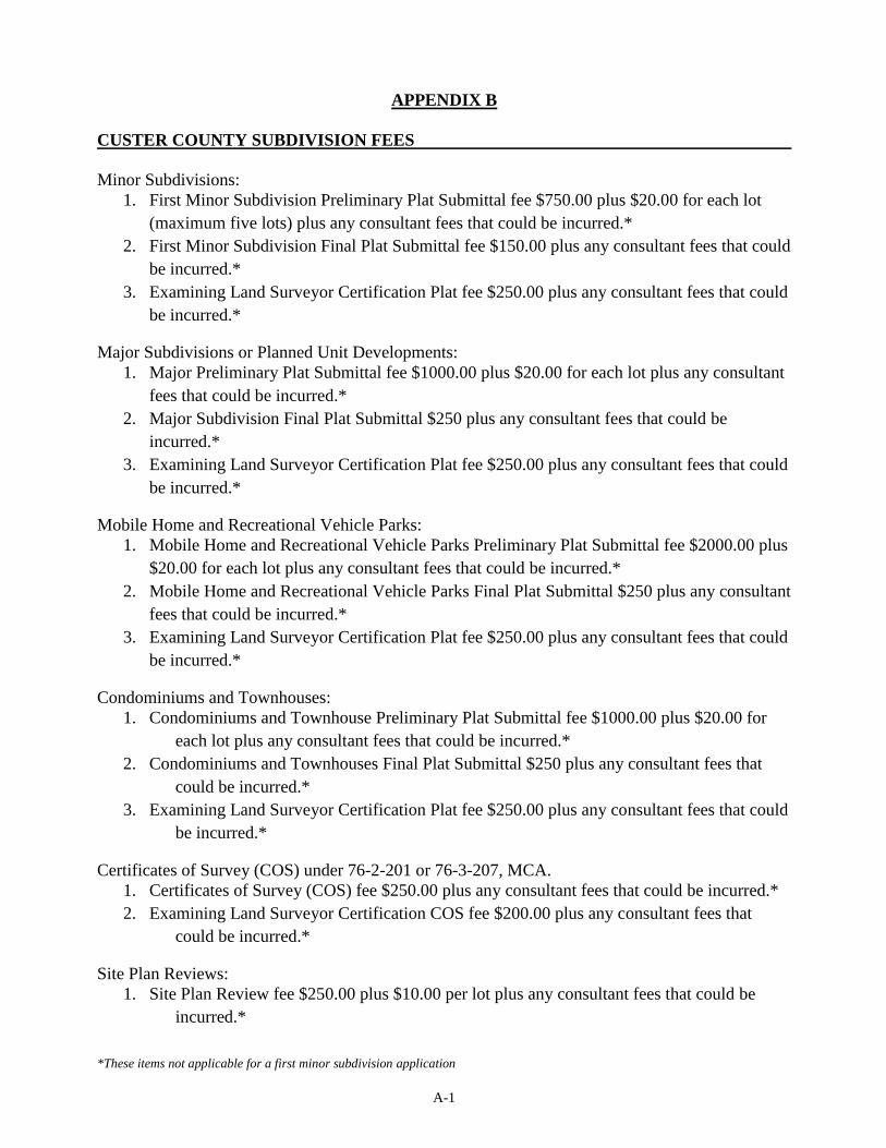
*These items not applicable for a first minor subdivision application
A-1
APPENDIX B
CUSTER COUNTY SUBDIVISION FEES
Minor Subdivisions:
1. First Minor Subdivision Preliminary Plat Submittal fee $750.00 plus $20.00 for each lot
(maximum five lots) plus any consultant fees that could be incurred.*
2. First Minor Subdivision Final Plat Submittal fee $150.00 plus any consultant fees that could
be incurred.*
3. Examining Land Surveyor Certification Plat fee $250.00 plus any consultant fees that could
be incurred.*
Major Subdivisions or Planned Unit Developments:
1. Major Preliminary Plat Submittal fee $1000.00 plus $20.00 for each lot plus any consultant
fees that could be incurred.*
2. Major Subdivision Final Plat Submittal $250 plus any consultant fees that could be
incurred.*
3. Examining Land Surveyor Certification Plat fee $250.00 plus any consultant fees that could
be incurred.*
Mobile Home and Recreational Vehicle Parks:
1. Mobile Home and Recreational Vehicle Parks Preliminary Plat Submittal fee $2000.00 plus
$20.00 for each lot plus any consultant fees that could be incurred.*
2. Mobile Home and Recreational Vehicle Parks Final Plat Submittal $250 plus any consultant
fees that could be incurred.*
3. Examining Land Surveyor Certification Plat fee $250.00 plus any consultant fees that could
be incurred.*
Condominiums and Townhouses:
1. Condominiums and Townhouse Preliminary Plat Submittal fee $1000.00 plus $20.00 for
each lot plus any consultant fees that could be incurred.*
2. Condominiums and Townhouses Final Plat Submittal $250 plus any consultant fees that
could be incurred.*
3. Examining Land Surveyor Certification Plat fee $250.00 plus any consultant fees that could
be incurred.*
Certificates of Survey (COS) under 76-2-201 or 76-3-207, MCA.
1. Certificates of Survey (COS) fee $250.00 plus any consultant fees that could be incurred.*
2. Examining Land Surveyor Certification COS fee $200.00 plus any consultant fees that
could be incurred.*
Site Plan Reviews:
1. Site Plan Review fee $250.00 plus $10.00 per lot plus any consultant fees that could be
incurred.*

*These items not applicable for a first minor subdivision application
A-2
Examining Land Surveyor Certification (ELS) fees include, Administrative Rules of Montana
(ARM) review involves checking all plats and COS’s prior to being filed with the Clerk and
Recorder’s for conformance to (ARM) 24.183.1101 Uniform Standards for Monumentation, ARM
24.183.1104 Uniform Standards for Certificates of Survey, ARM 24.183.1107 Uniform Standards
for Final Subdivision Plats. ELS review involves checking legal description accuracy,
mathematical closure, and area calculations.
*Consultant fees and charges, including, but not limited to Attorney's, Engineering’s, Sanitarian’s
or other Specialist’s and Professional’s Fees that could be incurred by Custer County during a
Minor, Major, Certificates of Survey, Site Plan, or Examining Land Surveyor review.
OCTOBER 2016

*These items not applicable for a first minor subdivision application
A-3