Embed Size (px)
Citation preview

1
Customizing ESRI Products to meet the Army War Fighter’s Needs
By
Daniel VisoneAbstract
The Project Director, Combat Terrain Information Systems (PD CTIS) is the MaterielDeveloper for the Digital Topographic Support System (DTSS). The DTSS provides theBattlefield Functional Areas (BFA) (i.e., Maneuver, Air Defense, Fire Support,Intelligence and Combat Service Support) of the Army Battle Command System (ABCS)with terrain overlays and map products in support of a Common Tactical Picture (CTP)of the battlefield. The CTP provides the foundation over which battle staffs execute theirspecific BFA mission requirements. The DTSS is using ArcGIS 8.3 and ArcIMS 4.0 tobuild an integrated GIS system in support of terrain data generation/enhancement, terrainanalysis, terrain visualization, and a web-based solution for delivering these products toother Army Command and Control Systems. This paper will focus on the use andcustomization of ArcGIS 8.3 and ArcIMS 4.0 in building the DTSS Build 8 and MapServer Build 1.4 software packages.
Paper Body
The Digital Topographic Support System (DTSS) is a tactical combat supportsystem capable of receiving, formatting, creating, manipulating, merging, updating,storing, and retrieving geospatial data and processing it into tactical decision aids fordigital or hardcopy distribution. Its mission is to provide commanders at brigadethrough theater level with timely and relevant terrain and battlespace information tosupport intelligence preparation of the battlefield and combat operations and to providegeospatial data management and terrain visualization capabilities for command andcontrol systems and weapons platforms. DTSS accepts geospatial data from the NationalImagery and Mapping Agency (NIMA) and commercial and national imagery sources.
The U.S. Army Program Executive Office for Command, Control, andCommunications - Tactical (PEO C3T) provides program management for all ArmyBattle Command Systems (ABCS). Project management is being provided by the ProjectDirector Combat Terrain Information Systems (PD CTIS), of the U.S. Army EngineerResearch and Development Center’s Topographic Engineering Center (TEC). The ArmyManeuver Support Center (MANSCEN) is the Combat and Training Developer, withinstitutional training provided by the National Geospatial Intelligence School (NGS).The development contractor is Northrop Grumman Information Technology TASC.
DTSS analysis capabilities include the creation of mobility, line-of-sight, 3-Dterrain visualization and special-purpose product analysis to support the decision-makingprocess. DTSS has the capability to augment, modify, update, and manage geospatialdata on the battlefield. DTSS also provides the updated map backgrounds and geospatialdata to other automated battlefield systems through the ABCS map server.

2
To provide state-of-the-art technology to the soldier to meet their requirements,the DTSS uses a mix of custom-developed software integrated with commercial-off-the-shelf image processing (Erdas Imagine 8.6), Geographic Information System (ESRI’sArcGIS 8.3), and database management (Informix 9.3) software.
The custom-developed software augments the GIS and Image Processing softwareto meet the requirements not totally met by the commercial packages. The custom-developed software for DTSS typically falls into “one of five” categories ofrequirements: Data Import, Data Generation, Data Analysis, Data Representation, andData Export/Dissemination. Common controls and common components (Visual Basicor C++) were developed to promote software reuse, and provide a better common lookand feel. Standard interaction between the common components is accomplished throughthe use of XML.
Data Import/Data Generation – To allow the soldiers to work with and manipulateterrain data provided by NIMA, data importers were developed to import standard NIMAproducts into ESRI personal geodatabases. The analyst can view NIMA data in its nativeformat and look at the associated features and attributes before performing the import.The data are imported into Geodata Models developed for the following NIMA productsbased on their specification: Foundation Feature Data (FFD), Vector Map (VMAP) 0-2,Urban Vector Map (UVMAP), Vector Interim Terrain Data (VITD), Digital TopographicData (DTOP), Digital Nautical Chart (DNC), and Interim Terrain Data (ITD). By havingthese data models on the system, the user can import NIMA data into a personalgeodatabase format with the proper feature classes based on the specification. This isextremely helpful when trying to value-add information to the database because theanalyst is provided pick lists of all allowable features and attributes for that data type.Using the ArcGIS out-of-the-box data editing functionality, the DTSS operator can nowcreate from scratch and/or value-add geospatial data, based on the NIMA specifications.A delimited file importer has also been developed to allow the operator to import anycommon delimited file (e.g. minefield database) into a personal geodatabase.

3
Import Tab of VPF to Geodatabase Importer Window
Selected Road in ArcMap

4
Attributes Window in ArcMap
DTSS Delimited File Importer Wizard – Define Fields Screen
Double click to adduseful description
Double click onfield to rename
Right click onrow to displaycontext menu
Double clickon field tochange type
Double clickon field tochange customproperties

5
Data Analysis – Custom workflows and engines were designed and integrated intoArcGIS 8.3 to generate tactical decision aids needed by the war fighter.
Visibility Analysis – DTSS provides the analyst with three Visibility Analysistools to create Site, Route, and Region Visibility plots. The Visibility Analysis productsdepict areas from a user-defined observation point as: 1) invisible (masked), 2) partiallyvisible (i.e., only a portion of the target is visible), and/or 3) visible. The VisibilityAnalysis products are created interactively from displayed data and user-input. Using theline-of-sight algorithms provided by ESRI, the following visibility analysis tools areavailable: site visibility (individual and cumulative), route visibility (individual, percentvisible, consecutive waypoint), region visibility (individual, percent visible), point toroute/region visibility, and route profile.
DTSS Visibility Analysis Toolbar
Region Visibility Form

6
Route Visibility Analysis – Maximum Consecutive Visible Product
Mobility Analysis is done through the integration of the NATO ReferenceMobility Model II (NRMM II) application programmer interfaces (APIs) developed bythe ERDC to generate off/on-road speed analysis based on vehicle type, terrain factors,and weather. Once the mobility prediction is performed, custom-developed software usesthe output of NRMM II as input to the Shaded Time Distance TDA (displays color-codedpolygons that show areas that can be traveled within user-defined time increments).
DTSS—NATO Reference Mobility Model II—Select Parameter Window
7
Sample Shaded Time Distance Analysis Output
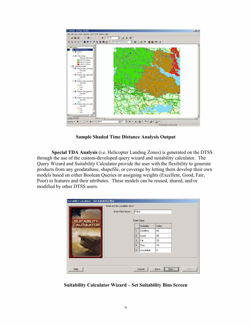
Special TDA Analysis (i.e. Helicopter Landing Zones) is generated on the DTSSthrough the use of the custom-developed query wizard and suitability calculator. TheQuery Wizard and Suitability Calculator provide the user with the flexibility to generateproducts from any geodatabase, shapefile, or coverage by letting them develop their ownmodels based on either Boolean Queries or assigning weights (Excellent, Good, Fair,Poor) to features and their attributes. These models can be reused, shared, and/ormodified by other DTSS users.
Suitability Calculator Wizard – Set Suitability Bins Screen

8
DTSS Data Query Results in ArcMap
.
Terrain Reasoning - DTSS Build 8 incorporates the initial release of a suite of toolsdesigned to generate products specifically suited for the Army’s Future Force. TheBattlespace Terrain Reasoning and Awareness (BTRA) suite of tools, developed by theERDC, is designed to aid the tactical commander’s understanding of the effects of thedynamic Battlespace Environment (BE) on personnel and equipment. BTRA productsmay be viewed similar to an IPB overlay, or exploited in a machine-readable fashion byother autonomous or semi-autonomous information systems. Certain products aredesigned to be dynamically interacted with to determine optimum and alternative Coursesof Action (COA) for predicted BE conditions, while considering the disposition offriendly forces, enemy forces, and non-combatants.
The backbone of the BTRA Maneuver Prediction (MP) capabilities is the maneuvernetwork. Network analysis tools have been used for many geospatially relevant problemsincluding traffic and routing analyses, but the exploitation has been limited to on-roadconditions. The maneuver network applies the robustness of network analysis to theproblem of on- and off-road military maneuver. Network analysis functions centeraround minimizing the costs associated with traversing pathways within the network.Network costs can be attributed to junctions (points) or to the edges (lines) that make upthe network. The most common cost analysis performed on networks is based ondistance, which is normally a function of the length of the network edges. Anothertraditionally attributed cost is capacity. These traditional tools are readily applied togeospatial problems to determine shortest distance route, fastest route, and duration for afixed volume of traffic to flow between defined positions.

9
Other attributes can be assigned to the network as well, and in BTRA’s case, those valuesare related to indices that are key to military maneuver. Elements such as concealment,based on the adjacent terrain features that would disrupt intervisibility, can also befactored into the analysis. These factors can be used in concert to help model optimumCOA for commanders to consider.
Example of a Maneuver Network
Example of a Minimum Cost Network Analysis

10
Data Representation - The DTSS Map Production Tool automatically generates a maplayout for any DTSS custom product and/or NIMA data that has been imported into ageodatabase using the custom DTSS importers. The Map Production Tool automaticallyplaces selected map elements into the layout.
DTSS Map Production Window

11
DTSS Map Production Window

12
ArcMap Window Showing DTSS Map Layout
Data Export/Dissemination – Custom Exporters were developed for DTSS to convertthe decision aids into a format readable by other Command and Control map viewers.The DTSS Overlay Provider (DOP) can convert any geodatabase, shapefile, or coveragein the ArcMap data view into formats viewable by the Joint Mapping Tool Kit (JMTK)and Command and Control Personal Computer (C2PC).
DOP Product Viewed in JMTK Display
Once decision aids, substitute map backgrounds, and terrain data updates have beengenerated for the customer, they are populated on the ABCS Map Server for distribution.The major functions of the Map Server are:

13
• To receive, store, and manage NIMA-produced digital geospatial data,products and custom geospatial data.
• To provide a web-based graphical user interface for querying NIMA andcustom geospatial data within a user-defined Area of Interest (AOI).
• To provide for the downloading of NIMA and custom geospatial data to otherABCS users.
These functions have been achieved through the customization of ArcIMS. Thefollowing Map Server requirements have been met through the customization:
• Graphical User Interface (GUI) Enhancements: The GUI has beenupgraded to take advantage of the ArcIMS 4.0 Java Connector. The GUI isnow Java enabled, which translates to a significant performance increase overthe previous Map Server builds.
• Commercial Data Support: Provides the capability of loading and retrievingcommercially formatted data. New commercial formats which are supportedin this build include: Geodatabases; Shape Files; Image Files; GIF; JPG; TIF;MPG; WRL; AVI; MPT; NTF; MGC; and Erdas Imagizer Files.
• Government Data Support: Provides the capability of loading andretrieving NIMA-formatted data to include: CIB, CARDG, ADRG, DTED,DOP, VPF products.
• MGRS and UTM Coordinate Query’s: Provides the capability to query theMap Server database by defining AOI with Military Grid Reference System(MGRS) or Universal Transverse Mercator (UTM) coordinates.
• Multiple Active Product Layers: Provides the capability to perform a singlequery of the Map Server database for multiple products.
• One-to-Many Replication: Provides the capability to replicate a Map Serverdatabase to multiple Map Server target databases.
Toolbar Panel
AOI/Metadata/Request Cart Panel
SubmapPanel
Product Type and Legend Panels
Map Display Panel

14
ABCS Map Server Interface
Product Type Pull-Down Options

15
Active Product Type and Layer
Summary – While commercial GIS and Image Processing technology provide a 90%solution to meet the war fighter’s geospatial requirements, customization for missionapplications is still required. PD CTIS, working with Northrop Grumman InformationTechnology TASC, has developed customized components to the ArcGIS 8.3 softwarethat not only meet the requirements of the DTSS operator, but also promote reuse forother Command and Control systems that use ESRI products.
Author Information:Name: Daniel VisoneTitle: Combat Terrain Information Systems Software LeadOrganization: US Army Engineer Research and Development Center, TopographicEngineering CenterAddress: 7701 Telegraph Road, Alexandria, VA 22315-3864Telephone: (703) 428-6920Fax: (703) 428-6302Email Address: [email protected]

16