Embed Size (px)
Citation preview
Proposal to County of San Luis Obispo AVILA POINT PROJECT
Amended July 3, 2014 D-1
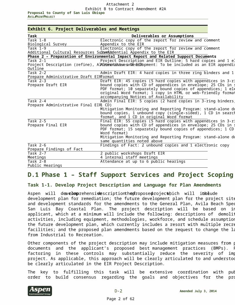
D. Work Plan Aspen has prepared this Work Plan to outline the key tasks that we propose in providing consulting services to the County prior to the start of the environmental review process and then based on the information gained from this first phase, the tasks that will be completed to prepare an Environmental Impact Report (EIR) for the project. As stated in the RFP, Aspen will assist the County in developing the appropriate type of environmental document. With the available information, Aspen has considered the options for an environmental document and concluded that a Program EIR with project-level details will be the best approach for the proposed project. Section C (Project Understanding) of this proposal provides a summary of the different types of EIRs that could be applied to this project and provides our recommendation based on the advantages and disadvantages of each document. Section 15160 of the CEQA Guidelines allows for tailoring of EIRs to meet the needs of a specific project as long as the content requirements are met (Section 15120). Aspen’s overall approach for the Avila Point Project will be to work closely with the County to clearly define the technical and management objectives of both phases of the project, establish specifics regarding the format and content of deliverables; integrate our technical, schedule, and cost requirements to effectively meet those objectives; and ultimately, develop a comprehensive and defensible document that fully serves the purposes of CEQA and its process. Based on the requirements of the RFP, we are presenting our scope of work under two phases. Phase 1 is the pre-EIR period, which will consist of extensive public outreach to the community of Avila Beach and building collaboration amongst the public agencies that are involved, the applicant, the County, and the Aspen Team. Development of the Project Description will be an ongoing task during this phase, and the CEQA requirements for scoping and the Notice of Preparation (NOP) will be fulfilled. Phase 2 of this project will include the CEQA process for preparation of a concise and comprehensive EIR. Our approach to both phases of the project is outlined below in Sections D.1 and D.2. Exhibit 6 below provides a summary of the key deliverables by task. Exhibit 6. Project Deliverables and Meetings
Task Deliverables or Assumptions Phase 1 – Staff Support Services and Project Scoping Task 1-1 Develop Project Description and Language for Plan Amendments
Draft Project Description: 4 hard copies and 1 electronic copy
Task 1-2 Prepare Initial Study and Notice of Preparation
4 hard copies and 1 electronic copy (additional copies upon request)
Task 1-3 EIR Scoping
EIR Scoping: Participation in 1 public scoping meeting; scoping report (Electronic Copy)
Task 1-4 Agency Coordination/ATCAT Meetings
Attendance at 12 monthly meetings 4 internal meetings with ATCAT regulatory agencies
Task 1-5 Senate Bill 18 Native American Consultation
Notification/invitation to consult with 6 regional tribes. Ten 4-hour meetings for consultation.
Task 1-6 Staff Meetings
Kick-off meeting and site visit; attend 2 meetings with County and two meetings with the applicant
Task 1-7 Peregrine Falcon Survey and Report
Electronic copy of the report for review and comment Appendix to EIR
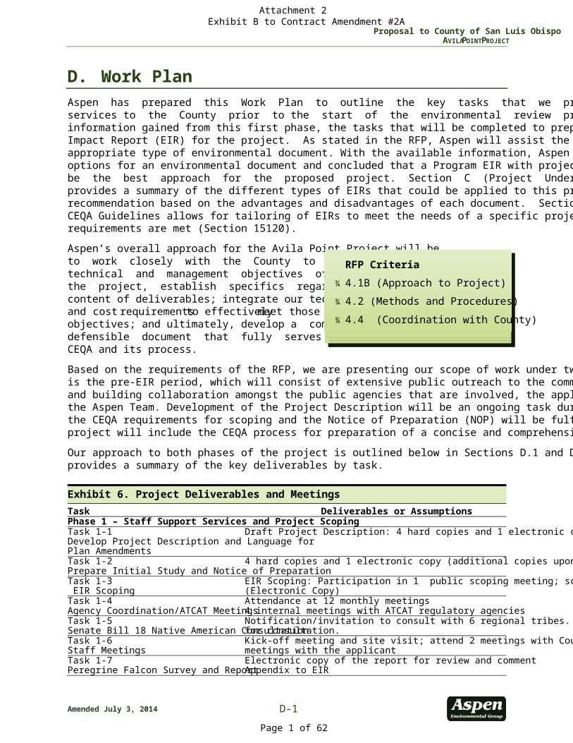
RFP Criteria
¾ 4.1B (Approach to Project) ¾ 4.2 (Methods and Procedures) ¾ 4.4 (Coordination with County)
Attachment 2 Exhibit B to Contract Amendment #2A
Page 1 of 62
Proposal to County of San Luis Obispo AVILA POINT PROJECT
D-2 Amended July 3, 2014
Exhibit 6. Project Deliverables and Meetings
Task Deliverables or Assumptions Task 1-8 Biological Survey
Electronic copy of the report for review and comment Appendix to the EIR
Task 1-9 Additional Cultural Resources Surveys
Electronic copy of the report for review and comment Confidential Appendix to the EIR
Phase 2 – Preparation of Environmental Impact Report and Related Support Documents Task 2-1 Project Description (refine), Alternatives and EIR Outline
Project Description and EIR Outline: 5 hard copies and 1 electronic copy Alternatives Development: To be included as an EIR appendix
Task 2-2 Prepare Administrative Draft EIR
Admin Draft EIR: 4 hard copies in three ring binders and 1 CD in Word format
Task 2-3 Prepare Draft EIR
Draft EIR: 45 copies (5 hard copies with appendices in 3-ring binders; 15 bound copies with CD of appendices in envelope; 25 CDs in searchable PDF format; 10 separately bound copies of appendices; 1 electronic copy in original Word format; 1 copy in HTML or web-friendly format); 45 accompanying Notices of Availability
Task 2-4 Prepare Administrative Final EIR
Admin Final EIR: 5 copies (2 hard copies in 3-ring binders; 2 bound copies; 1 CD) Mitigation Monitoring and Reporting Program: stand-alone document - 5 bound copies, 1 unbound copy (single-sided), 1 CD in searchable PDF format, and 1 CD in original Word format
Task 2-5 Prepare Final EIR
Final EIR: 55 copies (5 hard copies with appendices in 3-ring binders; 25 bound copies with CD of appendices in envelope; 25 CDs in searchable PDF format; 15 separately bound copies of appendices; 1 CD in original Word format) Mitigation Monitoring and Reporting Program: stand-alone document in same quantities noted above
Task 2-6 Prepare Findings of Fact
Findings of Fact: 2 unbound copies and 1 electronic copy
Task 2-7 Meetings
2 public workshops Draft EIR 4 internal staff meetings
Task 2-8 Public Hearings
Attendance at up to 6 public hearings
D.1 Phase 1 – Staff Support Services and Project Scoping Task 1-1. Develop Project Description and Language for Plan Amendments
Aspen will develop a comprehensive description of the proposed project, which will include the development plan for remediation; the future development plan for the project site; and the language and development standards for the amendments to the General Plan, Avila Beach Specific Plan, and the San Luis Bay Coastal Plan. The project description will be based on information provided by the applicant, which at a minimum will include the following: descriptions of demolition and remediation activities, including equipment, methodologies, workforce, and schedule assumptions; details regarding the future development plan, which currently includes a resort with multiple recreation resources and facilities; and the proposed plan amendments based on the request to change the land use designation from Industrial to Recreation. Other components of the project description may include mitigation measures from past environmental documents and the applicant’s proposed best management practices (BMPs). For several issue areas, factoring in these controls may substantially reduce the severity of impacts caused by the proposed project. As applicable, this approach will be clearly articulated to and understood by the team and will be clearly articulated in the EIR Project Description. The key to fulfilling this task will be extensive coordination with public agencies and the applicant in order to build consensus regarding the goals and objectives for the project site. Development of the
Attachment 2 Exhibit B to Contract Amendment #2A
Page 2 of 62
Proposal to County of San Luis Obispo AVILA POINT PROJECT
Amended July 3, 2014 D-3
project description will be based on a series of meetings, which will include the EIR scoping process and Avila Tank Farm Collaborative Assessment Team (ATCAT) meetings. Details regarding public involvement and collaboration are addressed below under Tasks 1-3 and 1-4. It is anticipated that this task will extend through the duration of Phase 1, the Pre-EIR stage, which could be up to a year. Aspen will provide the County with four (4) hard copies and one electronic copy of the draft Project Description.
Task 1-2. Prepare Initial Study/Notice of Preparation
Aspen will prepare an Initial Study that addresses all environmental issue areas consistent with Appendix G of CEQA. The main purpose of the Initial Study will be to analyze and describe the potential environmental impacts that would result from implementation of the proposed project and to identify the specific issues that will need to be addressed in the EIR. Aspen’s technical staff will review the background reports and all available studies provided by the applicant for preparation of the Initial Study. Aspen will prepare two administrative drafts of the Initial Study as part of this task. The first administrative draft will be a complete version of the Initial Study for the proposed project, not including alternatives. The methodology and criteria used for determining the significance of project impacts will be clearly and explicitly described in each issue area section, including any assumptions, models, or modeling techniques used in the analysis. Certain technical specialists on the Aspen Team will conduct field reconnaissance as warranted by their specific issue area(s) to appropriately characterize all potential impacts of the project. For the Cultural Resources evaluation, Applied EarthWorks (Æ) will complete a thorough review of 10 recently-identified reports, which were not included in the application package, plus any other available records. In addition, on May 23, 2014, Chevron supplied a package of documents prepared by Mr. Bob Gibson in 2001, 2002, 2010, and 2012, in addition to a set of maps showing the distribution of resources and their preliminary assessments of significance and integrity; none of these had been supplied with the application package, and all contain critical information that will require review, analysis, and integration into the existing data. This task did not originally include time to review and verify data presented in the numerous newly-received documents; therefore, additional funding has been included to augment Task 1-2 to cover this additional work. For each issue area the following will be determined: ¾ Appropriate baseline information to collect, appropriate level of detail, and whether any information
will be mapped. ¾ Use of specialized studies, surveys, and database searches (e.g., Cultural and Hazardous Materials). In
particular, surveys will be conducted for Peregrine Falcons during the nesting season from February to May 2014 (see Task 1-7).
¾ Descriptions of applicable plans, regulations, and policies (especially those that may reduce or avoid impacts).
Aspen will submit electronic copies (MS Word format for text and PDF format for graphics) of the first administrative draft Initial Study to County for review and comment. Edits from the County shall be provided in tracked changes, table format, or hard copy. Based on comments received, Aspen will revise the document.
Attachment 2 Exhibit B to Contract Amendment #2A
Page 3 of 62
Proposal to County of San Luis Obispo AVILA POINT PROJECT
D-4 Amended July 3, 2014
The second administrative document will include the revisions requested by the County provided for the first version of the document. Aspen will submit electronic copies (MS Word format for text and PDF format for graphics) of the second administrative draft Initial Study to the County for electronic distribution of the document to applicable County departments, divisions and districts for review and comment prior to preparation of the public document. Aspen will respond to any additional comments and prepare final version. For the final version of the Initial Study, Aspen will provide the County with one “camera-ready” hard copy version. Aspen will prepare the NOP for the EIR. The NOP will include a brief project description, location map and a list of probable environmental effects resulting from the project. Aspen will prepare a Draft NOP for review by County Planning staff, then incorporate any comments and finalize the NOP. Upon approval of the Screen Check Initial Study and NOP, Aspen will prepare and submit copies of these documents (together) to the County for distribution. The RFP does not identify an estimated number of copies of the Initial Study or NOP that will be needed for distribution. Therefore, it is assumed in this scope of work that Aspen will provide five copies of the Initial Study (four hard copies and one electronic copy), which is same number of copies as the Project Description and Administrative Draft EIR, to County for general distribution. If desired by the County, Aspen can distribute copies of the Initial Study and NOP to the State Clearinghouse, which may require a budget amendment. Under CEQA, the release of the Initial Study/NOP commences the scoping portion of the environmental review process. The purpose of the scoping process is to solicit input from agencies and the public as to the scope and content of the environmental document. As part of the scoping process, CEQA Section 15082 (c) (1) states that projects of regional or area-wide significance shall conduct at least one scoping meeting.
Task 1-3. EIR Scoping
As noted under Task 1-3 above, the release of the NOP commences the EIR scoping period which will be a collaborative, community-based public involvement process to further identify planning issues and set analytical parameters of the scope and content of the EIR. To this end, Aspen will compile a project mailing list in coordination with the County and the applicant, and maintain this list throughout the project and draft scoping letters for distribution to agency and non-agency interested parties. Aspen will also work with the County to plan and facilitate all aspects (e.g., logistics, staffing, presenting, providing materials) of one public scoping meeting. Based on a preliminary search for meetings sites, it appears that the Avila Beach Community Center and PG&E Community Center are currently used for public meetings and would be the primary options to hold the meetings for this project. Our proposed cost assumes attendance by Aspen’s Project Manager, Deputy Project Manager, and a land use specialist to respond to questions. The required attendance of any additional staff or attendance at any additional public meetings would require a commensurate scope and budget amendment. A presentation will be prepared by Aspen and reviewed by the County that includes general project information and a description of the CEQA process. Aspen has prepared many of these presentations for scoping meetings on behalf of government agencies and has templates in place. As part of this presentation we will work with the County and the applicant to provide visual simulations in a format that could be presented at the scoping meeting. Because visual resources will be a primary issue of public concern, these simulations will be integrated into the scoping presentation and meeting materials to clearly convey the appearance of the proposed project from visually sensitive areas.
Attachment 2 Exhibit B to Contract Amendment #2A
Page 4 of 62
Proposal to County of San Luis Obispo AVILA POINT PROJECT
Amended July 3, 2014 D-5
Throughout the 30-day public scoping period, Aspen will scan and compile all scoping comments and materials associated with scoping into a database, which will allow Aspen to efficiently sort comments by name/organization, address, and resources issue/category of interest as well as quantify the number of individuals raising similar concerns. At the end of the EIR scoping period, Aspen will use this information to prepare a Scoping Report, considering any written scoping comments received and a summary of oral comments provided at the public scoping meetings.
Task 1-4. Agency Coordination/ATCAT Meetings
As stated in the RFP, the ATCAT meetings occur monthly, and with the assumption that Phase 1 will last for a year, Aspen will attend 12 ATCAT meetings during Phase 1. In the event that supplemental meetings are scheduled, we are prepared to work with the County to make them cost effective, such as holding conference calls with meeting materials provided electronically, use the Go-To-Meeting program, or other web-based programs. In addition, we have retained expert facilitators, PMC, who specializes in public participation. We understand the importance of effectively communicating how to participate in the CEQA process, the roles of the agencies, applicant, and environmental consultant, and intent of scoping (particularly that it is conducted early in the process in the interest of engaging the public in issues identification). The ATCAT meetings are intended to facilitate coordination amongst the agencies involved with the proposed project. As such, Aspen will assist the County in any necessary coordination efforts. Aspen’s Project Manager and Deputy Project manager will regularly attend the meetings to provide support for tasks such as presentations, recordation, and preparations for the meetings. In addition, our cost includes attendance of technical staff at four ATCAT meetings to ensure that the identification of the remediation plan and the required actions are accurately identified. We have identified the use of facilitators at meetings as an optional task in this proposal. In the event that Aspen is attending the meetings as representatives of the County, Aspen will provide a full written report of the meeting(s). In addition, Aspen will consult with the County to define the parameters of Aspen’s involvement in the meetings. To this end, we will not discuss any of the issues without permission from the County. Although this task focuses on coordination with the ATCAT, Aspen recognizes that there may be the need to coordinate with other agencies (e.g. Public Health Department, transportation agencies, Coastal Commission) during this phase of the project. As necessary, Aspen will attend up to four focused meetings with the ATCAT Agency representatives. In particular, coordination with the APCD will be necessary during the review of the project applicant’s air quality technical report, and early coordination with the Coastal Commission is advisable. We will identify our coordination with agencies and work with the County prior to making these contacts. Risk Assessment/Remedial Action Plan. One of the key issues that will be discussed at the ATCAT meetings is the review and approval of the Remedial Action Plan (RAP) for the Avila Tank Farm site. The Aspen Team includes professional engineers, geologists and certified engineering geologists, who are specialists with extensive relevant experience. The Aspen Team also includes highly qualified experts to evaluate the site risk issues (both human health and ecological), including one of only a handful of Diplomates of the American Board of Toxicology (DABTs) in California. These resources have been identified to assist the County in the review of the applicant-prepared risk assessment and the RAP. Two documents have been prepared which evaluate risks: the Draft Risk Management Plan (RMP) by Arcadis (2008) and the “Supplemental Human Health Risk Assessment” (SHHRA) prepared by McDaniel Lambert, Inc. (2011). The RMP summarizes the efforts of the ATCAT subcommittees (Human Health Risk
Attachment 2 Exhibit B to Contract Amendment #2A
Page 5 of 62
Proposal to County of San Luis Obispo AVILA POINT PROJECT
D-6 Amended July 3, 2014
Working Group and Ecological Risk Working Group) to evaluate site areas or features that present potentially unacceptable risk to human or ecological receptors, groundwater quality, or other environmental conditions within the context of the proposed future use of the project site. The SSHRA presents estimated risks to a variety of future potential receptors in specific site areas identified in the Development Plan. The results of these reports (and previous investigations) will be used to formulate management recommendations that will serve as the foundation for the RAP and, which must be conducted in accordance with RWQCB, DTSC and EPA guidance documents. Based on the pre-bid meeting, the applicant is in the process of preparing the Site Conceptual Model and anticipates that the RAP will be ready by the end of the year. The Aspen Team is prepared to review the RAP and to provide comments. Our team will prepare a technical memorandum summarizing our findings and recommendations. The Aspen Team’s review of the RAP will proceed through the following steps: ¾ Preliminary RAP Review. Perform a preliminary review of the RAP to confirm that the screening
process used in the RAP meets the requirements of the County.
¾ Site Conceptual Model. Review the adequacy of the site conceptual model (SCM) to support determinations and decision-making used for remedy selection, and future design and implementation. The RAP presents a brief discussion of the nature and extent of contamination and chemicals of concern in the affected media. These conditions reflect the historical use of the site. Our team will review the SCM to determine if it is adequate to support decision-making or if additional site evaluations are warranted to support future activities, including remedy implementation. Our review of the SCM will consider the lateral and vertical extent and range of concentrations that will remain, and the geotechnical properties of the soil.
¾ Remedial Goals and Criteria. Review the risk evaluations and methods for selecting remedial goals for the project. Risk evaluations are another critical element of the RAP that leads to significant decisions about the site and remedial actions. We will review the appropriateness of the criteria for the site conditions and will assess the degree of conservativeness in those estimates of risk. The relevance of the criteria to actual site conditions, the assumptions used in their development, and how or whether statistical evaluations of the data were done, or are appropriate for decision making, will be reviewed.
¾ Remedial Alternatives. Review the approach used in performing remedial alternatives analysis and remedy selection and reasonableness of the recommended alternative. We will review remedial alternatives developed for the site for reasonableness, approximate costs, and compliance with pertinent guidance, including USEPA’s nine criteria for remedy selection, with recognition that the RWQCB is the lead agency for RAP approval. The Aspen Team will review the proposed approach and likelihood of achieving remedial goals.
¾ Remedy Implementation. We will review the adequacy of the planned approach to implementing the remedy. At this time it is not known how detailed the final approved RAP will be with respect to the methods of RAP implementation. Our team has considerable years of experience preparing, implementing, overseeing and evaluating RAPs. Often, in order to provide maximum flexibility in unique circumstances, RAPs are developed as performance-based, rather than prescriptive, documents. This approach is often the best for all parties involved, as it allows for creativity in methodology to reduce cost and impacts. However, cost reduction pressures can threaten to increase impacts. Cost-based examples of increased potential impacts include: creation of excessive contaminated soil stockpiles during removals, employing less than optimal air monitoring equipment or locating equipment at ineffective positions, allowing uncredentialed equipment operators or workers on site, abating asbestos or lead paint without third-party oversight, etc. Our experienced team will proactively identify these pressures, evaluate whether they have the potential to result in
Attachment 2 Exhibit B to Contract Amendment #2A
Page 6 of 62
Proposal to County of San Luis Obispo AVILA POINT PROJECT
Amended July 3, 2014 D-7
significant impacts, and recommend project design features or mitigation methods to reduce the impacts to less than significant levels.
Task 1-5. Complete Senate Bill 18 Native American Consultation
Amendments to the County’s General Plan and the Avila Beach Specific Plan trigger California Senate Bill 18 (SB-18) (Chapter 905, Statutes of 2004), which requires cities and counties to consult with Native American Indian tribes during the adoption or amendment of local general plans or specific plans. Aspen Team member, Applied Earthworks (Æ), is cognizant of the prior discussions Chevron has had with local Native American groups and the potential controversy that may arise over the development of an area considered important to them. We therefore anticipate that tribal outreach and participation will require a substantial level of effort and a sophisticated approach to this sensitive issue. The project will require two separate tracks for Native American participation, one explicitly geared to the Specific Plan amendment and another for the project EIR. For the Specific Plan amendment, SB-18 requires the County “to contact, provide notice to, refer plans to, and consult with tribes” identified by the NAHC. The purpose of this consultation is for preserving, or mitigating impacts to, important cultural places located on land that might be affected by the proposed plan amendment. Based on our past knowledge and experience, we understand that the NAHC list of local Tribal Government contacts for SB-18 consultation currently includes six groups: the Santa Ynez Band of Mission Indians, the Barbareño/Ventureño Band of Mission Indians, the Salinan Tribe of San Luis Obispo and Monterey Counties, the Xolon Salinan Tribe, the Coastal Band of the Chumash Nation, and the Northern Chumash Tribal Council. On behalf of the County, Æ will initiate SB-18 consultation in accordance with the Tribal Consultation Guidelines published in November 2005 by the Governor’s Office of Planning and Research (OPR). We will confirm the most current list of Tribal Government contacts with the NAHC and contact all that are identified. The process involves an initial notification and invitation to consult; the tribes then have 90 days from the time they receive the invitation to respond, indicating their request for consultation. There is no statutory limit on the duration of consultation; often there are numerous meetings, and follow-up conferences may extend through the period of Planning Commission or Board of Supervisors deliberations on the proposal. We do not expect all the tribes we contact to respond positively to our initial request; for example, the Santa Ynez, Barbareño, and Coastal bands of the Chumash frequently do not accept invitations to consult on projects in San Luis Obispo County, deferring rather to the Northern Chumash tribes. Given the sensitivity of the project and its notoriety among various tribal groups, however, we anticipate a robust response to the initial request for consultation; we therefore anticipate that numerous meetings (and possible site visits) will be required for the initial round of consultation. It has been our experience that meeting individually with each separate group or individual is a more effective method for eliciting serious and meaningful responses, and we advocate this approach over larger meetings with representatives of multiple tribal groups. Repeat or follow-up conferences are likely to be needed as well. For budgeting purposes, we have anticipated ten 4-hour meetings to complete this phase of consultation. If additional meetings or conferences are required, we will gladly facilitate and participate in those on a time and materials basis. Æ will take minutes of all meetings and keep an accurate administrative record of the discussions. Our budget includes time for a clerical staff person to attend the meeting, take and transcribe the notes, and distribute them to all parties after each meeting. Our budget also includes time for a Cultural Resources specialist from Aspen to attend these meetings and serve as a resource in confirming the results of the meetings. This individual will review and comment on all meeting minutes prior to finalizing the minutes for distribution.
Attachment 2 Exhibit B to Contract Amendment #2A
Page 7 of 62

Proposal to County of San Luis Obispo AVILA POINT PROJECT
D-8 Amended July 3, 2014
Once the SB-18 consultations are concluded, or while they are in progress, Æ will also initiate the broader outreach required for the EIR. The NAHC maintains a separate, more extensive list of local tribal contacts for this kind of consultation, which does not require the same kind of direct, government-to-government contact stipulated under SB-18. Æ will initiate outreach for the EIR by contacting the NAHC to request a search of their confidential Sacred Lands Inventory files, obtain the local Native American contact list, and seek their input on any potential conflicts or concerns. Æ will prepare and send letters describing the project to the contacts identified by the NAHC. The letters will invite tribal representatives to confer on potential impacts to tribal resources. To ensure effective Native American participation during this phase, we will follow up with phone calls and/or emails to each of the individuals or groups on the list. All responses will be recorded and summarized in the EIR.
Task 1-6. Staff Meetings
An initial kick-off meeting and site visit with the County and applicant will be held soon after the contract is awarded. It is assumed that this meeting and site visit will be attended by Aspen’s Project Manager, Deputy Project Manager, and key technical specialists for remediation/risk; aesthetics; biological resources; noise; land use; recreation; geology and soils; wastewater; and water and hydrology. In addition to the kick-off meeting and site visit, members of the Aspen Team will be available for two meetings with the County for development of the Project Description and two meetings with the applicant. Aspen’s Project Manager and Deputy Project Manager will work closely with the County to plan and facilitate all aspects (e.g., logistics, staffing, presenting, providing materials) of the staff meetings. For the purposes of estimated cost it has been assumed that these meetings will be attended by the Project Manager and up to three (3) Team members.
Task 1-7. Peregrine Falcon Survey and Report
Aspen biologists will work with Peter Gaede, Ornithologist, to carry out the Peregrine Falcon Surveys. The scope of work includes site visits to conduct the survey. Mr. Gaede will make his first visit to the project site on Thursday, February 6th to assess site conditions with regard to the Peregrine Falcon. Based on this initial site visit, Mr. Gaede will work with Aspen biologists to develop a plan and overall schedule for the surveys. Aspen will coordinate with the County and Chevron to provide access to the project site for all survey events. This task includes: ¾ the use of a qualified ornithologist with extensive raptor experience ¾ development of a survey outline and anticipated schedule of site visits ¾ up to 10 individual full day site visits (or more frequent visits of a shorter duration equal to 10 full day
site visits) to conduct surveys ¾ oversight of the raptor experts work by a qualified Aspen biologist ¾ preparation of a report that documents the findings of the surveys. Aspen will review the information provided by Mr. Gaede and work with him to prepare a draft report for review and comment by the County. Aspen will revise and finalize the report based on comments received from the County. The cost estimate assumes one set of review comments from the County prior to completing the survey report.
Attachment 2 Exhibit B to Contract Amendment #2A
Page 8 of 62
Proposal to County of San Luis Obispo AVILA POINT PROJECT
Amended July 3, 2014 D-9
Task 1-8. Biological Survey
Aspen will conduct botanical surveys to determine the presence of special status plant species or vegetation communities within the project area. If possible the surveys will include a buffer of at least 250 feet. Surveys will be floristic in nature and comply with California Native Plant Society (CNPS) and California Department of Fish and Wildlife (CDFW) requirements. Surveys will include spring and summer seasons in order to assess the range of species that occur on the project site and to detect late blooming species. Special attention will be made to identify listed plants including species considered rare in the County of San Luis Obispo. The locations of rare plants will be logged using a Trimble GPS and mapped on aerial photography. Plant community descriptions will conform to CDFW guidelines (i.e., Sawyer Keeler-Wolfe). Holland classification systems will be used where plant communities do not conform to published descriptions. Aspen will note the presence of any weed infestations and document their location(s) and distribution in the project area. Aspen will conduct general surveys for common and sensitive wildlife. Surveys will focus on the detection of sensitive birds (along with observations of nesting behavior), mammals, reptiles, invertebrates, and amphibians that may occur in the project area. These include but are not limited to silvery legless lizard, shoulder band snails, and wood rats. Aspen will complete a wildlife habitat assessment that that describes habitat suitability for sensitive species that have been observed or have the potential to occur within the project area. Observations of sensitive plants and wildlife will be logged using a Trimble GPS and mapped on aerial photography. Aspen will note the presence and distribution of invasive wildlife in the project area. Aspen will prepare a Biological Technical Report that includes the results of the biological surveys and a general assessment of the project areas potential to support other rare species. The report will include photos of the site, descriptions of habitats and sensitive species that are present or have the potential to occur, maps of sensitive species locations or territories, and copies of all CNDDB forms for sensitive species observations.
Task 1-9. Additional Cultural Resource Surveys
This scope of work addresses additional cultural resource surveys and reporting needed to identify archaeological and historical sites within the approximately 95-acre project site. Portions of the cultural resource work are already covered under the existing Task 1-2 (IS/NOP); however, initial data gathering and our recent meetings with the County and Chevron have identified significant gaps in the application package and the information provided prior to initiation of the project. For example, at a meeting on May 21, 2014, archaeologist Robert Gibson revealed that no historical archaeological studies had been conducted for the project. His focus has been exclusively on prehistoric (i.e. Native American) archaeology, and even though there are several known historic period sites they have not been surveyed, recorded, or evaluated for significance. Therefore, this task includes collection of additional field data needed to complete the inventory of resources on the tank farm property and preparation of a stand-alone technical report presenting the new archaeological data along with the inventory and evaluation of the historical built environment. Should additional effort be required to document resources on the project site, evaluate their significance and eligibility for the California Register of Historical Resources, prepare data recovery plans, or conduct other studies not currently anticipated, Aspen will be available to provide these services under a separate scope of work. Æ will conduct additional field surveys to identify and record historic archaeological deposits that have not been recorded previously. We will not resurvey the entire property, but will target those locations where archival research indicates that historical sites are most likely to be preserved. To help identify target locations, interpret the function and significance of identified resources, and otherwise facilitate
Attachment 2 Exhibit B to Contract Amendment #2A
Page 9 of 62
Proposal to County of San Luis Obispo AVILA POINT PROJECT
D-10 Amended July 3, 2014
the survey, Æ will review local archival sources and conduct additional research at the Map and Imagery Library on the University of California, Santa Barbara campus. We anticipate that no more than 40 acres of the property is sensitive for historic archaeological remains and will need to be surveyed. Based on a preliminary review of historic maps and aerial photos, we expect that as many as 18 historical features may be discovered during the survey. These features will be documented on California Department of Parks and Recreation (DPR) recording forms as part of a single archaeological site complex. Site and feature locations will be logged using a Trimble GeoXH GPS receiver and mapped on aerial photos with topographic overlays. Æ will produce a separate technical report on all historic-period resources, both archaeological and architectural, on the tank farm property. The report will include a complete set of archaeological site records and maps resulting from the new survey, as well as historic building documentation forms, photographs, and other details. Because the report will include information on archaeological and historical site locations, it will be a confidential appendix to the EIR.
D.2 Phase 2 – Preparation of Environmental Impact Report and Related Support Documents
This section presents the eight main tasks we have identified for preparing the EIR. A detailed discussion of the technical approach for each of the issue areas is provided in Section E of this proposal.
Task 2-1. Project Description (refine), Alternatives and EIR Outline
At the onset of Phase 2, it is expected that the proposed project will be well-defined as a result of the extensive coordination discussed above under Phase 1. As such, the project description will be refined and ready for final approval early on during Phase 2. Based on the RFP, the alternatives analysis will rely on information related to existing site contamination, and it is expected that the range of alternatives will consist of multiple on-site design alternatives. As the purpose of the alternatives identified for analysis in the EIR is to lessen one or more significant impacts that would be expected to occur due to the proposed project’s implementation, potential alternatives could include a reduced project “footprint” and/or a reduced operational/visitor capacity. Aspen has extensive experience developing alternatives and will work closely with County staff to develop alternative project options taking into account economic, environmental, legal and technological factors, as well as regulatory limitations, site constraints, and concerns and comments raised by the public and agencies as part of the scoping process. For the purposes of our proposed cost, we are assuming that up to four alternatives will be evaluated in the EIR, including the proposed project and the No Project Alternative. The Description of Alternatives will include a section briefly discussing those alternatives that were identified but eliminated from detailed consideration due to either their infeasibility, inability to meet the proposed project’s most basic objectives, or failure to avoid any significant environmental effects. Considering the public involvement that will be associated with this project, the process for developing alternatives may be lengthy and complex. In this scenario, Aspen would present details of the process in an appendix to the EIR. In addition, the EIR will include a separate discussion regarding the different alternatives that were considered for the remediation of the project site and provide an explanation of how and the basis for the selection of the remedial alternative for the project. Aspen will also develop an EIR Outline that delineates the structure of the document, Aspen’s strategy for meeting the County’s 200 page length requirement, and those technical issues to be evaluated in the
Attachment 2 Exhibit B to Contract Amendment #2A
Page 10 of 62
Proposal to County of San Luis Obispo AVILA POINT PROJECT
Amended July 3, 2014 D-11
EIR. The EIR Outline will be based on State and County CEQA guidelines, Aspen’s knowledge of project-specific issues, peer review of the technical studies provided by the applicant, Aspen’s independent research, and information collected during the project’s scoping process. Four (4) hard copies and one electronic copy of the draft Project Description and EIR Outline will be submitted to the County.
Task 2-2. Prepare Administrative Draft EIR
Aspen will prepare a concise, accurate, and objective environmental review document that fully complies with CEQA and County requirements. The document will minimize the use of technical jargon so that the information conveyed is accessible to decision-makers and the public. The Administrative Draft EIR will impartially and accurately analyze the environmental impacts of the proposed project. In order to meet the County’s request to limit the EIR analysis to no more than 200 pages, Aspen will present detailed technical analyses and data tables as appendices to the EIR. Aspen has successfully employed this strategy to reduce the length of documents on past projects. Aspen Team members will perform a thorough peer review of each technical report prepared on behalf of the applicant and provide feedback to the County regarding the adequacy of the data, analysis, and findings of each report. Aspen will verify data presented in these reports through independent research and field surveys. One cycle of data review, data request preparation and submittal, and review of data responses has been factored into the scope and associated cost of each of the EIR’s technical analyses under Task 2-2. Should the data and analyses prepared by, or on behalf of, the applicant be considered inadequate following the peer review and question cycle, a commensurate scope and cost modification may be needed on an issue-specific level. Efforts under Task 2-2 additionally include the cost of site visits and field reconnaissance, as appropriate by issue area, by technical team members. Impacts will be clearly assigned to each phase of the proposed project, i.e., the remediation activities, the plan amendments, and the proposed future development. The methodologies and criteria used for determining the impacts of the project will be clearly and explicitly described in each technical section of the EIR. These will include any assumptions, models, or modeling techniques used in the analyses. The determination of impacts will be based on thresholds of significance developed in accordance with CEQA requirements, the County’s guidelines and requirements, and other recently approved environmental documents. As noted previously under Task 1-1, the analysis will consider any existing conditions of approval or mitigation measures that the County would like factored into the impacts assessment, as well as any newly identified applicant-proposed environmental controls or BMPs. If significant impacts are identified, mitigation measures will be included to reduce the severity of the impacts to the extent possible. Two types of mitigation measure will be recommended, the first are measures that will address primary impacts, and the second are measures that address secondary impacts. Mitigation measures will be alpha-numerically coded to correspond to their respective impact criterion. The effectiveness and feasibility of mitigation measures will be discussed, and the level of significance after mitigation will be identified. The impact assessment will consider direct, indirect, alternative, and cumulative impacts. Each issue area will include consideration of cumulative projects consistent with Section 15130 of the State CEQA Guidelines. In consultation with the County, Aspen will prepare a cumulative scenario that will include a list of past, present, and probable future projects. The cumulative scenario will be incorporated into the Project Description and provided to the Aspen Team for evaluation. Cumulative impacts are predominantly associated with the construction period, which often result in impacts that
Attachment 2 Exhibit B to Contract Amendment #2A
Page 11 of 62
Proposal to County of San Luis Obispo AVILA POINT PROJECT
D-12 Amended July 3, 2014
are temporary. Nonetheless, should the project incrementally contribute to any identified adverse and significant cumulative impacts, appropriate mitigation will be developed and included in the EIR. In addition, consistent with State CEQA Guidelines Section 15126.6(d), it is assumed that the alternatives will not be evaluated at the same level of detail as the proposed project. Aspen will submit four (4) hard copies (in three-ring binders) and one (1) CD in original format (Word) of the Administrative Draft EIR, including appendices.
Task 2-3. Prepare Draft EIR
Aspen will prepare a Draft EIR ready for public review and comment. The Draft EIR will incorporate the County’s comments on the Administrative Draft EIR. To ensure consistency and to avoid conflicting directions, it is assumed that the County Project Manager will provide one set of unified review comments on the Administrative Draft EIR for Aspen’s use in revising the document. Aspen will complete revisions to the Administrative Draft EIR in conformance with the County’s consolidated comments. The completed Draft EIR will be prepared and distributed to an approved distribution list provided by the County Planning Department. Aspen will prepare a Notice of Availability (NOA) that would accompany each Draft EIR (45 copies). The NOA will also be used as a mailed notice, if additional notices are sent out by the County. Also, Aspen will file the NOA with the County Clerk as required by CEQA, and will prepare and file the CEQA-required Notice of Completion that goes with the copies of the draft to the State Clearinghouse. Aspen will reproduce 45 copies of the Draft EIR as follows: five (5) hard copies with appendices (in three- ring binders); fifteen (15) bound copies with appendices included as a CD in an envelope; twenty five (25) CDs (with graphics and appendices) in “searchable” .pdf format; ten (10) separately bound copies of appendices; one (1) electronic copy in original format (Word); one (1) copy of the Draft EIR in an HTML, or other acceptable web-friendly format, so text and graphics can be easily placed on the county’s web site, which will include breaking the document in smaller, easily downloadable portions; and all spreadsheets and databases, including GIS layers will be submitted electronically according to the specifications in Section 2.6(H) of the RFP. The Mitigation Monitoring and Reporting Program will not be submitted at this point in the process.
Task 2-4. Prepare Administrative Final EIR
Near the close of the Draft EIR public review period, Aspen will begin to prepare an Administrative Final EIR that includes responses to comments submitted by the public, interested agencies, and the applicant and make any necessary revisions to the Draft EIR for its finalization. Aspen will work with the County to ensure that all comments received are properly identified and logged into a database so they can be easily tracked and retrieved. Aspen will prepare responses to individual comments or groups of similar comments and will make all necessary revisions to the Draft EIR with tracked revisions using text strikeout and underlining techniques. Aspen will organize all the comment letters by source and review each letter to appropriately identify all comments contained in it. The individual comments will then be categorized according to their resource/issue-specific focus, and each senior technical analyst will be provided the comments requiring his or her technical expertise for responses. The draft responses to comments will be submitted to Aspen’s Project Manager to ensure that the responses adequately address the comments in a clear, concise, and unbiased manner and that they are consistent between disciplines.
Attachment 2 Exhibit B to Contract Amendment #2A
Page 12 of 62
Proposal to County of San Luis Obispo AVILA POINT PROJECT
Amended July 3, 2014 D-13
Responses that are within this proposal’s scope and budget consist of explanations, elaborations, or clarifications of the data contained in the Draft EIR. If new analysis, issues, alternatives, or substantial project changes need to be addressed, a contract amendment may be required. However, this scenario is not anticipated. As part of the finalization process, Aspen will additionally prepare the project’s MMRP, consistent with Public Resources Code Section 21081.6. Aspen will coordinate with the County as to any preferred formatting for the MMRP. The introduction will explain the technical and legal parameters that require the preparation and adoption of a MMRP, the parties responsible for its implementation, and description of compliance and non-compliance violation levels. This discussion will be followed by a comprehensive table with an alpha-numeric identification of each mitigation measure, its title, the party (or parties) responsible for its implementation and the actions that are involved, the timing of implementation, and identification of the party (or parties) and method (or methods) of compliance verification and reporting. Consistent with the RFP, the MMRP will be prepared as a “stand alone” document. Aspen will submit five (5) copies (2 three-hole drilled, 2 bound, 1 CD) of the Administrative Final EIR with appendices.
Task 2-5. Prepare Final EIR
Aspen will prepare a Final EIR that incorporates the County’s comments on the Administrative Final EIR. Aspen will obtain all comments on the Administrative Final EIR from the County Project Manager, who will compile one set of unified review comments for use in revising the document. Aspen will complete revisions to the Administrative Draft EIR in conformance with the County’s comments. Aspen will reproduce 55 copies of the Final EIR as follows: five (5) hard copies with appendices (in three-ring binders); twenty five (25) bound copies with appendices as CDs in envelopes at back of document; twenty five (25) CDs (with graphics and appendices) in “searchable” .pdf format; fifteen (15) separately bound copies of appendices; and one (1) CD in original software format (Word).
Task 2-6. Prepare Findings of Fact
Per RFP Section 2.3, Aspen will prepare the EIR’s Findings of Fact, consistent with State CEQA Guidelines Section 15091. Aspen will coordinate with the County to ensure that a format agreeable to staff and decision makers is used. Aspen completed the Findings of Fact for the Topaz Solar Farm and can apply the template used for that document to the proposed project, thereby expediting the process. Assuming that this type of structure is applied, the Findings of Fact will include a brief project description, summary of the public record, verification of EIR certification by the Planning Commission, and the findings for all impacts identified in the Final EIR, including the Findings and Supportive Evidence for impacts that have been identified as either significant but mitigable to a level of less than significant and significant and unavoidable. The Findings of Fact will additionally include CEQA General Findings and a summary of the MMRP. If necessary, the Findings of Fact will additionally include a Statement of Overriding Considerations, consistent with State CEQA Guidelines Section 15093. Aspen will submit two unbound copies and one electronic copy of the Findings of Fact.
Task 2-7. Meetings
Draft EIR Workshop
Aspen will prepare the Notice of Completion of the Draft EIR for submittal to the State Clearinghouse for responsible agencies and public review. During the public review period, the Aspen Team (including key
Attachment 2 Exhibit B to Contract Amendment #2A
Page 13 of 62
Proposal to County of San Luis Obispo AVILA POINT PROJECT
D-14 Amended July 3, 2014
subconsultants) will assist the County in planning and conducting two (2) public workshops to present the findings of the Draft EIR. For past public workshops, Aspen has prepared and presented a PowerPoint presentation to the public, which summarized the project description, alternatives, and the findings of the Draft EIR. The public then had the opportunity to ask questions and the issue area authors provided direct responses. The workshops have also included an “open house” period where Aspen provided detailed graphics and/or information handouts regarding the critical issue areas and the Aspen Team was available to answer questions.
Internal Meetings
Members of the Aspen Team will be available for four internal staff meetings with the County. Aspen’s Project Manager and Deputy Project Manager will work closely with the County to plan and facilitate all aspects (e.g., logistics, staffing, presenting, providing materials) of the staff meetings. For the purposes of estimated cost it has been assumed that these meetings will be attended by the Project Manager and up to three (3) Team members.
Optional Meetings
If ATCAT meetings continue through the Phase 2 process, Aspen will be available to attend the meetings. These meetings would require a commensurate scope and cost modification.
Task 2-8. Public Hearings
Aspen shall attend up to six (6) public hearings. It is assumed that each of these meetings will be attended by Aspen’s Project Manager and that technical staff will attend two of the four anticipated hearings before County decision makers. It has been our experience that technical staff are generally needed at the second hearing on controversial projects. An hour estimate and cost has been factored into our cost proposal for each meeting to prepare brief presentations and/or to review project-related documents and files in response to submitted or anticipated questions. Consistent with our efforts on the Topaz Solar Farm and California Valley Solar Ranch, it is assumed that the County will be responsible for coordinating and advertising the meetings, arranging for meeting equipment and hand-out materials, and any special services that may be required, such as translators or court reporters.
Attachment 2 Exhibit B to Contract Amendment #2A
Page 14 of 62
Proposal to County of San Luis Obispo AVILA POINT PROJECT
Amended July 3, 2014 E-1
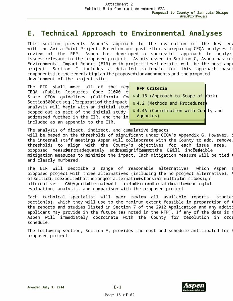
E. Technical Approach to Environmental Analyses This section presents Aspen’s approach to the evaluation of the key environmental issues associated with the Avila Point Project. Based on our past efforts preparing CEQA analyses for similar projects and review of the RFP, Aspen has developed a successful approach to analyzing potential environmental issues relevant to the proposed project. As discussed in Section C, Aspen has concluded that a Program Environmental Impact Report (EIR) with project-level details will be the best approach for the proposed project. Section C includes a detailed rationale for this approach based on the each of the project components, i.e., the remediation plan, the proposed plan amendments, and the proposed development of the project site. The EIR shall meet all of the requirements set forth in CEQA (Public Resources Code 21000 et seq.) and the State CEQA guidelines (California Code of Regulations, Section 15000 et seq.). Preparation of the impact analysis will begin with an initial study. If issue areas are scoped out as part of the initial study, they will not be addressed further in the EIR, and the initial study will be included as an appendix to the EIR. The analysis of direct, indirect, and cumulative impacts will be based on the thresholds of significant under CEQA’s Appendix G. However, if necessary, during the internal staff meetings Aspen will collaborate with the County to add, remove, or alter the impact thresholds to align with the County’s objectives for each issue area. In cases where the applicant’s proposed measures do not adequately address a significant impact, the EIR will include feasible mitigation measures to minimize the impact. Each mitigation measure will be tied to the impact criteria and clearly numbered. The EIR will describe a range of reasonable alternatives, which Aspen anticipates will include the proposed project with three alternatives (including the no project alternative). As stated under Task 2-1 of Section D, is expected that the range of alternatives will consist of multiple on-site design alternatives. As per CEQA, the alternative will include sufficient information to allow meaningful evaluation, analysis, and comparison with the proposed project. Each technical specialist will peer review all available reports, studies and data that pertain to their section(s), which they will use to the maximum extent feasible in preparation of the EIR. This includes the reports and studies listed in Section 7 of the 2012 Application and any additional reports that the applicant may provide in the future (as noted in the RFP). If any of the data is found to be inadequate, Aspen will immediately coordinate with the County for resolution in order to avoid delays in the schedule. The following section, Section F, provides the cost and schedule anticipated for Phases 1 and 2 of the proposed project.
RFP Criteria
¾ 4.1B (Approach to Scope of Work) ¾ 4.2 (Methods and Procedures) ¾ 4.4A (Coordination with County and
Agencies)
Attachment 2 Exhibit B to Contract Amendment #2A
Page 15 of 62
Proposal to County of San Luis Obispo AVILA POINT PROJECT
E-2 Amended July 3, 2014
E.1 Aesthetics Issues and Background
The analysis of aesthetics utilizes resource-specific qualitative and quantitative terminology. The follow-ing defines terms utilized within this scope to ensure understanding of the proposed methodology and scope of work: ¾ Key Observation Point (KOP): One or a series of points on a travel route or at a public/private use
area, where the view of a proposed activity would be most revealing. ¾ Viewshed: The landscape that can be directly seen under favorable atmospheric conditions, from a
KOP or along a transportation corridor. Foreground View: 0–1 mile Middleground View: 1–3 miles Background View: 3–5 miles
¾ Visual Contrast: Opposition or unlikeness of different forms, lines, colors, or textures in a landscape. Generally, increased visual contrast within foreground distances would be more noticeable to viewers than increased visual contrast within background distances.
¾ Visual Quality: The relative worth of a landscape from a visual perception point of view. The proposed project is a 95-acre site within the Industrial land use category and is located at 1717 Cave Landing Road, in the community of Avila Beach. The property is adjacent to and east of downtown Avila Beach and extends back (north) to Cave Landing Road. The site is within the boundaries of the San Luis Bay Area Plan (Coastal) and the Avila Beach Specific Plan. Issues associated with aesthetics include the overall visual change of the site from being primarily open space (retired tank farm) to the “vision” submitted by Chevron, which includes construction of a resort, development of a coastal bluff trail and other trails throughout the site, remote parking areas serving the resort, and golf cart facilities for use on site. Furthermore, these future development activities would require amendments to the General Plan, Specific Plan and Local Coastal Plan. These local plans include a number of policies, design guide-lines, and development standards related to aesthetics and lighting.
Approach to Development of Environmental Setting
The coastal areas of San Luis Obispo County include some of the region’s most important visual resources, with their scenic views and coastline neighborhood aesthetic considered a trademark of Cali-fornia. Avila Beach has a unique beach aesthetic. The proposed project is located in the upper coastline bluff of Avila Beach, with views of the Pacific Ocean and horizon. The project site currently contains open space, with minimal visibility of the remaining tank farm infrastructure from outside of the prop-erty boundary. Receptors in the immediate vicinity with views of and through the site include motorists on Avila Beach Drive and Cave Landing Road, recreation and open space users from adjacent uses, and commercial/residential development west of the site in downtown Avila Beach. As discussed in the Land Use Policy Consistency section, land use and sensitive receptor information will be gathered by site reconnaissance and shared with all EIR technical staff. This inventory will be presented within the environmental setting to assist the reader in understanding the existing viewsheds and visual quality of the area, establishing baseline for how those conditions could be affected by project implementation. For the purposes of the EIR, the aesthetics environmental setting will include photographs and text descriptions for the acceptable visual simulations prepared by the applicant (2012 Draft Visual Simula-tions). Additional KOP locations and baseline photographs and descriptions may be identified (beyond
Attachment 2 Exhibit B to Contract Amendment #2A
Page 16 of 62
Proposal to County of San Luis Obispo AVILA POINT PROJECT
Amended July 3, 2014 E-3
the five included in the 2012 Draft Visual Simulations) in coordination with the County. The need for additional KOPs would take into account sensitive receptor locations, unique natural features, locations of prominent future development features, and other viewshed specifics garnered from site reconnais-sance as well as revised project application materials. The proposed project site is atop a hill, which makes selecting KOPs critical in establishing baseline conditions. The environmental setting would also present applicable laws, ordinances, regulations, and standards necessary for evaluating potential visual resources impacts. These sources include, but are not limited to, applicable portions of the San Luis Obispo County General Plan (Conservation and Open Space Element, Coastal Zone Framework for Plan-ning – Land Use Element), Avila Beach Specific Plan, Countywide Design Guidelines, County Ordinance Title 19 – Building and Construction Ordinance, and Title 22 of the Land Use Ordinance.
Approach to Evaluation of Impacts and Development of Mitigation Measures
In consultation with County staff, Aspen will formulate impact statements and significance criteria utilizing the four aesthetics impact evaluation criteria contained in the CEQA Guidelines Environmental Checklist Form (Appendix G) as a starting point, as well as considering applicable goals, objectives, ordinances, and policies from the documents identified in the environmental settings discussion provided above. CEQA significance criteria include an evaluation of the proposed project’s potential to: ¾ Have a substantial adverse effect on a scenic vista. ¾ Substantially damage scenic resources, including, but not limited to trees, rock outcroppings, and his-
toric buildings within a state scenic highway. ¾ Substantially degrade the existing visual character or quality of the site and its surroundings. ¾ Create a new source of substantial light or glare which would adversely affect day or nighttime views
in the area. Aspen will peer review the 2012 Draft Visual Simulations and will work closely with County staff (and the applicant) to conceptualize and revise the visual simulations as part of the Development Plan and for inclusion within the EIR aesthetics analysis. Any additional visual simulations (if deemed necessary) would be prepared consistent with the five approved KOPs to allow for a robust analysis of the visual contrast associated with the proposed project. It is assumed that the applicant may be asked to revise the 2012 Draft Visual Simulations and/or provide additional simulations based on Aspen Team and County review. As needed, the EIR aesthetics analysis can be supplemented with additional photography and sim-ulations. Should additional or replacement simulations be required, the Aspen Team can provide this as an optional task. To prepare an in-depth analysis, the aesthetics section will include a defined study area of the viewsheds from which the proposed project might be seen. KOPs that have the potential to result in visual impacts at particular locations will be identified and evaluated in the analysis. Project-induced visual changes will be determined based on evaluation of anticipated visual contrast and project dominance. A written visual analysis will be presented for each KOP to supplement the visual simulations (also included graphically as part of the aesthetics analysis), describing the existing visual character, quality, viewer sensitivity and exposure, to serve as the foundation for impact evaluation per agreed upon thresholds of significance. Development Plan for Remediation. Because remediation activities would be ground level and subterranean, the visual impacts of this activity are limited to views of temporary construction equipment and activities. Due to the short-term construction-based aspect of this type of remediation, view disruptions will be limited in duration at any KOP and temporary in nature (only during the remediation phase).
Attachment 2 Exhibit B to Contract Amendment #2A
Page 17 of 62
Proposal to County of San Luis Obispo AVILA POINT PROJECT
E-4 Amended July 3, 2014
Plan Amendments. The most applicable plan with respect to aesthetics of the proposed project is the Avila Beach Specific Plan. The Plan defines a number of aesthetic design goals and criteria for development of Avila Beach. The Plan also included language specific to the proposed project site. However, it only discusses a potential vision for the property and requires that future development include plan amendments to the General Plan, Specific Plan and Local Coastal Plan to further define the redevelopment of the site once any remediation activities had occurred at the site. As such, the aesthetics analysis will not only be CEQA compliant, but also evaluate proposed changes to the Avila Beach Specific Plan based on the finalized Development Plan. These updates will be linked to the analysis and may tier off any mitigation included within the aesthetics analysis to minimize visual impacts. Additionally, the proposed project will be evaluated for consistency with all applicable polices, and ordinance standards set forth by the County as applicable to aesthetics and visual resources. Development Plan for Future Use of the Avila Tank Farm Site. Due to the proximity of Avila Beach Golf Resort, the proposed project would not introduce a new development of significant visual contrast for the surrounding community. However, development of the site consistent with the “vision” described in RFP Section 1.9 would introduce highly prominent structures and change the overall aesthetic of south-ern Avila Beach. Overall urbanization of the site, which includes roadways and commercial structures, would alter the existing visual character of the site and its surroundings. This change due to develop-ment of the site may result in significant visual contrast impacts when compared to existing conditions. Depending upon review of the finalized Development Plan and visual simulations, the proposed project may also degrade scenic vistas from public KOPs and private property owner viewsheds in the vicinity of the site. While the analysis of visual impacts can be considered qualitative and subjective, the Aspen team has significant experience in preparing and publicly testifying to methods utilized and determina-tions made under CEQA. The proposed project also has the potential to result in lighting impacts due to the 24-hour usage of the proposed resort, as well as potential lighting impacts associated with internal roadways and parking facilities. Details of any proposed lighting plan would be requested of the applicant to perform a thorough evaluation of lighting impacts to adjacent receptors. Due to the height of the proposed devel-opments and distance to adjacent parcels, no shade/shadow impacts are expected. The EIR will include mitigation measures for the proposed project, as practicable and feasible, to reduce potential visual resource impacts. Any mitigation measures will be prepared consistent and taking into account all of the plan amendments associated with the proposed project. Potential mitigation measures could include: end of day activities to minimize view impacts from temporary construction equipment during remediation; recommendations for site plan limitations to minimize visual impacts; use of screen walls, wall surface and other external hues, and/or landscaping features to soften visual contrast; and direction and planning refinements to minimize any intrusive lighting.
E.2 Air Quality, Greenhouse Gases and Climate Change For the purposes of this proposal, the air quality section will include impact analyses of the following: criteria pollutant air quality, air toxics pollutant, odors, and climate change/greenhouse gas (GHG) emissions. It is possible that one or more of these analyses such as climate change/GHG emissions, would be prepared as a separate section within the EIR. Issues and Background
The proposed project would generate emissions of dust (particulate matter) and equipment exhaust (criteria and air toxics pollutants) during the project’s remediation activities, construction activities, and long-term operation emissions in the San Luis Obispo County Air Pollution Control District’s (APCD) juris-
Attachment 2 Exhibit B to Contract Amendment #2A
Page 18 of 62
Proposal to County of San Luis Obispo AVILA POINT PROJECT
Amended July 3, 2014 E-5
diction within the South Central Coast Air Basin (SCCAB). Additionally, the project site remediation work would create additional volatile organic compound emissions including some hazardous air pollutants, such as benzene, toluene and xylene. The project site is located within an area of the SCCAB that is currently designated as “non-attainment” of the California Ambient Air Quality Standards (CAAQS) for particulate matter (PM10) and ozone, but is designated as attainment of all other CAAQS and all National Ambient Air Quality Standards. Demolition emissions will come from soil and groundwater remediation activities including contaminated soil excavation and hauling. Construction emissions from site preparation grading activities and the erection of structures will come from the associated on-road and off-road vehicle/equipment emissions and activities that cause fugitive dust. Operational emissions will result from the operation of the proposed recreation properties, including associated fuel use and induced traffic. Specific issues, such as naturally occurring asbestos, Valley Fever, asbestos or lead paint exposure from demolition activities, or odor issues from site remediation will also need to be evaluated based on studies to be performed by the applicant or based on research of other available project site information. The discussion of Valley Fever may be included in the Hazards and Hazardous Materials section, rather than the Air Quality section, per San Luis Obispo County APCD scoping letter comments on previous projects. The proposed project would generate GHG emissions during the remediation, construction and opera-tion activities. Remediation and construction would generate GHG emissions from the use of off-road construction equipment and on-road vehicle trips. Operation emissions would come directly from the traffic induced from the project and natural gas or other fuel use. Other indirect emissions sources, such as electricity use and the potential loss of vegetative carbon intake due to permanent vegetation removal would also be assessed. Approach to Development of Environmental Setting
The environmental setting information will include a discussion on the applicable State and federal air quality standards and current air quality planning efforts within the County; the current attainment status of the project area; information on the climate and meteorological conditions of the area; ambient air quality data from monitoring stations near the site and/or representative of the site, indicating local trends and patterns of air pollutant concentrations; and identification of all surrounding sensitive receptors. In addition, information will be presented regarding other potentially hazardous air-born contaminants, such as hydrogen sulfide (H2S) and asbestos. Much of this information is available from public databases maintained by the California Air Resources Board (CARB) and the APCD. The most recent APCD Clean Air Plan will be reviewed for applicable information and the APCD will be consulted to determine if recent information is available. A discussion of the other applicable County plans such as the County’s General Plan, San Luis Bay Area Plan (Coastal), and the Avila Beach Specific plan will be included in the setting. The GHG/Climate Change environmental setting will include information on global climate change and the potential local impacts of climate change, introduction of regulated GHGs, and federal, State and local regulatory setting to regulate GHG emissions. Additionally, applicable elements of the County’s Energywise Plan will be included in the setting discussion for GHG/Climate Change. Approach to Evaluation of Impacts and Development of Mitigation Measures
An air quality “technical report” in the form of a comprehensive emission modeling analysis (i.e., CalEEMod or separate spreadsheet calculation) for air pollutants (criteria and air toxic pollutants) and GHGs is assumed to be completed by the project applicant. Aspen will review the report and work with the County, the ATCAT Agencies, and the project applicant to determine appropriate equipment, activity, and project schedule assumptions to prepare the emissions modeling analysis. This review will
Attachment 2 Exhibit B to Contract Amendment #2A
Page 19 of 62
Proposal to County of San Luis Obispo AVILA POINT PROJECT
E-6 Amended July 3, 2014
include the evaluation of the assumptions provided in the applicant’s Remedial Action Plan (RAP) and the Development Plan. Aspen’s review would also ensure the following: the proper assumptions are used and documented; the scenarios evaluated consider a reasonable worst-case situation for each phase of development (e.g., remediation, construction, and operation); the report will be completed using emissions calculation methodologies and emissions factors that meet APCD and CARB guidance. The final draft of the project applicant’s air quality technical report will be included as an appendix to the EIR. The EIR will identify APCD construction mitigation recommendations and permitted equipment control requirements for mitigating the construction and operation emissions to ensure that appropriate emis-sion reduction measures are considered as part of the project’s emissions estimates. Applicant proposed measures will be applied, as appropriate. County air quality policies relative to development shall be discussed, and the project’s proposed miti-gated criteria pollutant (NOx, SOx, PM10, PM2.5, VOC/ROG, and CO) emissions shall be compared to the APCD thresholds of significance provided in the 2012 APCD CEQA Air Quality Handbook. Additionally, the project’s conformance with air quality plans and APCD permitting requirements and rules compli-ance will be evaluated. Where appropriate, additional mitigation measures will be recommended to mit-igate significant air quality impacts to the extent feasible and mitigated emissions estimated. It is assumed that air dispersion modeling of the criteria pollutant emissions will not be necessary for EIR. The APCD will be contacted to confirm if any specific analysis or air dispersion modeling/health risk analysis for air toxic pollutants emitted during site remediation is warranted. If the project complies with a qualified GHG reduction plan the project would be presumed to have less than significant GHG emissions impacts per APCD CEQA guidelines. If the project does not have a quali-fied GHG reduction plan then the project’s annual GHG emissions estimate, where the remediation and construction emissions would be amortized over the project life, would be compared to the APCD Bright-Line Threshold of 1,150 metric tons CO2 per year (MT CO2e/yr) for land use development proj-ects. Additionally, the proposed project will be analyzed to determine conformance with federal, State and local regulations, policies and goals for GHG emissions. Applicable mitigation measures would be identified reduce the remediation, construction, and opera-tion GHG emissions as necessary. If the project does not include a qualified GHG reduction plan, then it is possible that project’s GHG emissions after mitigation may exceed the Bright-Line Threshold of signifi-cance for GHG emissions. The air quality impacts of cumulative development surrounding Avila Point would be assessed. Addi-tional coordination with the APCD would be performed to ensure that the list of cumulative projects, are adequate and complete. Identified project alternatives will be evaluated at a conceptual level of detail, with particular emphasis on their ability to mitigate significant air quality impact(s). Applicable mitiga-tion for cumulative and project alternative impacts would be developed. Development Plan for Remediation. During remedial actions, demolition, and redevelopment, the vari-ous phases of activities would introduce a range of air pollutant and GHG emissions sources, in the form of heavy equipment, haul trucks, worker vehicles, fugitive dust, and releases from contaminated soils. Heavy equipment and hauling of excavated soils and demolition debris are likely to be the primary sources of air pollutants from the remediation activities. Remediation activities also have the potential to release odorous substances from contaminated soils. Therefore, the potential for nuisance odors dur-ing the project’s remediation activities will need to be evaluated and mitigated as necessary.
Attachment 2 Exhibit B to Contract Amendment #2A
Page 20 of 62
Proposal to County of San Luis Obispo AVILA POINT PROJECT
Amended July 3, 2014 E-7
Plan Amendments. The Project’s contemplated uses could create air quality compatibility conflicts. The long-term consequences of the proposed plan amendments will be assessed for potential conflicts with the General Plan’s Conservation and Open Space Element’s air quality goals and policies. The County’s General Plan does not have a separate air quality element, and other applicable regional and local plans do not have detailed air quality requirements beyond the Coastal Plan’s requirement for consistency with APCD rules and regulations and requiring APCD review of development projects. The long-term consequences of the proposed plan amendments will be assessed for potential air quality conflicts and the potential to introduce air quality compatibility issues with the General Plan’s Conservation and Open Space Element’s goals, policies and strategies. The County has adopted the Energywise Plan that includes policies for GHG emissions reductions. The long-term consequences of the proposed plan amendments will be assessed for potential GHG/climate change conflicts and the potential to introduce compatibility issues with the Energywise Plan’s goals, policies and strategies. Development Plan for Future Use of the Avila Tank Farm Site. The Development Plan would bring increased activity to the site along with additional air pollutant and GHG emissions. Construction and operation would include air pollutant emissions from heavy equipment, traffic, new residents, and visitors to the resort and commercial facilities being contemplated. Aspen will identify and document the anticipated construction activities and phases, and the modeled local and regional air pollutant and GHG emissions including the potential new stationary sources of air pollutant emissions. These emissions will be compared to APCD significance thresholds and appropriate mitigation will be recommended. The Development Plan will also be assessed for conformance with the General Plan’s Conservation and Open Space Element’s air quality goals, policies and strategies and the Energywise Plan’s GHG/climate change goals, police and strategies.
E.3 Biological Resources The Biological Resources section of the EIR will consider the existing baseline conditions and provide an analysis of impacts to plants, wildlife, and habitats associated with the proposed remediation and redevelopment activities. To support this work, Aspen has carefully assembled a team of biologists with extensive experience and knowledge of the species that occur in the project area. More importantly, the team includes biologists with knowledge in site remediation and energy development projects. This experience provides the County with expert resources to accurately assess the project and develop rea-sonable mitigation measures where necessary. This section describes our current understanding of the existing biological resources that occur at the project site, and provides a summary discussion of how Aspen will address those issues.
Issues and Background
The proposed project would occur within approximately 95 acres of previously disturbed and natural lands near the community of Avila Beach. The sites historic use as a tank farm is well known and most of these facilities have been removed. Several documents, including a 2004 Ecological Evaluation Supple-ment I (2004 EES) and 2005 Ecological Evaluation Supplement II (2005 EES), have been prepared to doc-ument biological resources on the project site. Aspen has reviewed these documents and other relevant information for biological resources and we are familiar with the resources that are known or have the potential to occur on-site. Current conditions on the site support a variety of non-native and native plant communities including (but not limited to) wetlands, coastal scrub, and oak woodlands. Wildlife usage varies however the pro-posed project has the potential to support over 60 special-status plant and wildlife species. Previous
Attachment 2 Exhibit B to Contract Amendment #2A
Page 21 of 62
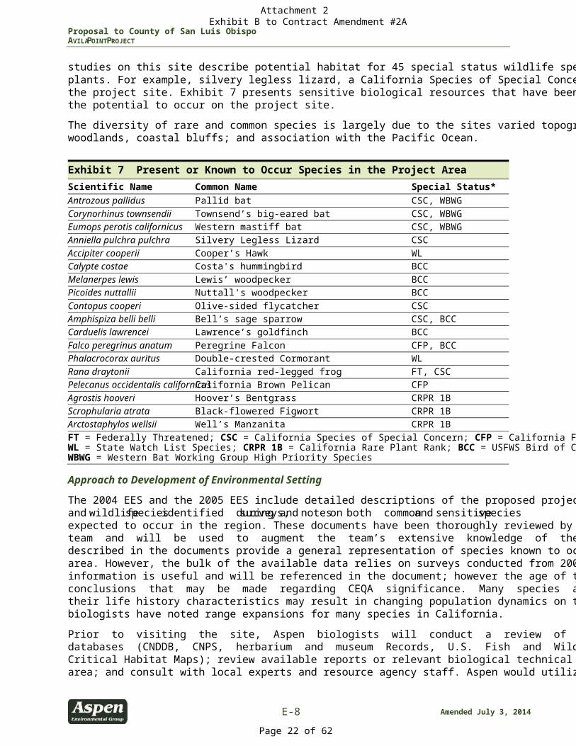
Proposal to County of San Luis Obispo AVILA POINT PROJECT
E-8 Amended July 3, 2014
studies on this site describe potential habitat for 45 special status wildlife species and 19 special-status plants. For example, silvery legless lizard, a California Species of Special Concern, has been observed on the project site. Exhibit 7 presents sensitive biological resources that have been documented or have the potential to occur on the project site. The diversity of rare and common species is largely due to the sites varied topography; presence of oak woodlands, coastal bluffs; and association with the Pacific Ocean. Exhibit 7 Present or Known to Occur Species in the Project Area Scientific Name Common Name Special Status* Antrozous pallidus Pallid bat CSC, WBWG Corynorhinus townsendii Townsend’s big-eared bat CSC, WBWG Eumops perotis californicus Western mastiff bat CSC, WBWG Anniella pulchra pulchra Silvery Legless Lizard CSC Accipiter cooperii Cooper’s Hawk WL Calypte costae Costa's hummingbird BCC Melanerpes lewis Lewis’ woodpecker BCC Picoides nuttallii Nuttall's woodpecker BCC Contopus cooperi Olive-sided flycatcher CSC Amphispiza belli belli Bell’s sage sparrow CSC, BCC Carduelis lawrencei Lawrence’s goldfinch BCC Falco peregrinus anatum Peregrine Falcon CFP, BCC Phalacrocorax auritus Double-crested Cormorant WL Rana draytonii California red-legged frog FT, CSC Pelecanus occidentalis californicus California Brown Pelican CFP Agrostis hooveri Hoover’s Bentgrass CRPR 1B Scrophularia atrata Black-flowered Figwort CRPR 1B Arctostaphylos wellsii Well’s Manzanita CRPR 1B FT = Federally Threatened; CSC = California Species of Special Concern; CFP = California Fully Protected Species; WL = State Watch List Species; CRPR 1B = California Rare Plant Rank; BCC = USFWS Bird of Conservation Concern; WBWG = Western Bat Working Group High Priority Species
Approach to Development of Environmental Setting
The 2004 EES and the 2005 EES include detailed descriptions of the proposed project site, a list of plant and wildlife species identified during surveys, and notes on both common and sensitive species expected to occur in the region. These documents have been thoroughly reviewed by Aspen’s biological team and will be used to augment the team’s extensive knowledge of the project area. Surveys described in the documents provide a general representation of species known to occur in the project area. However, the bulk of the available data relies on surveys conducted from 2003 through 2005. This information is useful and will be referenced in the document; however the age of the data limits the conclusions that may be made regarding CEQA significance. Many species are difficult to detect and their life history characteristics may result in changing population dynamics on the project site. Similarly, biologists have noted range expansions for many species in California. Prior to visiting the site, Aspen biologists will conduct a review of available literature and species databases (CNDDB, CNPS, herbarium and museum Records, U.S. Fish and Wildlife Service [USFWS] Critical Habitat Maps); review available reports or relevant biological technical studies completed in the area; and consult with local experts and resource agency staff. Aspen would utilize existing survey data
Attachment 2 Exhibit B to Contract Amendment #2A
Page 22 of 62
Proposal to County of San Luis Obispo AVILA POINT PROJECT
Amended July 3, 2014 E-9
and conduct reconnaissance-level surveys to verify the information provided in the 2004 and 2005 EES reports, and note any changes that may have occurred in conditions since the previous biological surveys were conducted. In Phase 1 of this project, Aspen will conduct surveys for the Peregrine Falcons during the nesting season from February to July 2014. Aspen’s Biology Team with the assistance of an Ornithologist will conduct the surveys and monitoring for the County. Aspen will also conduct a biological survey, which will include botanical vegetation mapping, general wildlife surveys and sensitive habitat assessment. Both of these studies will be included as appendices to the EIR and will be used in this evaluation. At the completion of the data acquisition Aspen would develop the environmental setting for the EIR. This information will be based on both information and data provided by the applicant and independent data compiled by Aspen. Aspen’s proposed team of biologists are extremely familiar with the types of biological resources documented and potentially occurring within the proposed project area and will provide a thorough and resource-based characterization of the environmental setting to provide a solid baseline for the analysis of the proposed project’s potential direct and indirect effects. Based on a review of the existing information and reconnaissance-level surveys, the environmental setting will include an assessment of the following: ¾ Plant communities and available habitats, including any habitats considered sensitive by CDFW; ¾ Common plants and wildlife, including wildlife that may use or occupy the site seasonally; ¾ Special-status plants and wildlife that occur or have the potential to occur at the project site, including
federally and state-listed species; plants designated with a California Rare Plant Rank (CRPR) 1A, 1B, 2, 3, and 4; state Species of Special Concern; and locally important species;
¾ Jurisdictional features; ¾ Wildlife movement corridors; and ¾ A regulatory setting, including applicable federal, State, and local laws, plans and guidelines.
Approach to Evaluation of Impacts and Development of Mitigation Measures
Aspen will prepare an objective, science-based impact analysis for biological resources resulting from the remediation and plan implementation of the proposed project. Aspen will develop and assess the feasibility of proposed mitigation measures for short-term and long-term impacts. The biological resources impact analysis will be based on a thorough inventory of the habitats and species that have the potential to occur on the project site or that would otherwise be affected by the remediation and implementation of the proposed future development. The goal of the biological resource section is to provide a concise, legally defensible document that thoughtfully discloses impacts to biological resources and provides feasible mitigation measures that effectively balance resource protection with development goals. Unless otherwise directed by the County, significance criteria used in the biological resources impact assessment will follow generally accepted thresholds of significance, which provide habitat-specific criteria for protection of biological resources including wetlands, riparian habitats, native grasslands, and native trees. Under these thresholds, the project would have a significant effect on biological resources if it would: ¾ Substantially reduce or eliminate species diversity or abundance; ¾ Substantially reduce or eliminate quantity or quality of nesting areas; ¾ Substantially limit reproductive capacity through losses of individuals or habitat; ¾ Substantially fragment, eliminate, or otherwise disrupt foraging areas and/or access to food sources;
Attachment 2 Exhibit B to Contract Amendment #2A
Page 23 of 62
Proposal to County of San Luis Obispo AVILA POINT PROJECT
E-10 Amended July 3, 2014
¾ Substantially limit or fragment range and movement, geographic distribution of animals, and/or seed dispersal routes; or
¾ Substantially interfere with natural processes, such as fire or flooding, upon which the habitat depends.
Aspen recognizes the importance of positive working relationships and will make it a priority to coordi-nate and consult with the County and all applicable resource agencies (with approval of the County) dur-ing the preparation of the EIR. The Aspen Team has positive working relationships with the agencies relevant to this project, including the CDFW, USFWS, and the USACE, as well as the County. Through these relationships and extensive relevant project experience, Aspen biologists will prepare an inde-pendent and objective analysis of the proposed project and implement mitigation strategies that are appropriate to the scale of identified project impacts. These impacts and mitigation solutions will be clearly communicated to the public without the use of jargon or overly complicated language. Some of the important themes that will be addressed in the EIR include potential impacts to: ¾ Oak Woodlands. Project related activities would potentially result in direct and indirect impacts to
oak woodlands. Oak woodland is considered a sensitive resource by San Luis Obispo County and is considered rare and worthy of consideration by CDFW. Although oak woodlands may be revegetated as part of mitigation for on-site impacts, revegetation results in mature oak woodland being replaced with young oak tree plantings. This results in different habitat function and values in the revegetated areas compared to mature woodlands. In addition, oak trees provide a valuable seasonal resource from mast crops and provide year round shelter to a large variety of small animals and birds. Because of the sensitive nature of this habitat and its importance to a variety of common and special-status wildlife, impacts would likely be considered significant and require mitigation. Mitigation strategies could include avoidance and off-site compensation to mitigate impacts to habitat values, in addition to on-site revegetation.
¾ Wetlands The 2004 and 2005 EES report the presence of wetlands within the project site (man-made seasonal wetlands that have formed in several former tank bottoms). The applicant has indicated that the USACE, after a site visit, determined the wetlands were not jurisdictional under Section 404 of the Clean Water Act. These wetland pools however have the potential to support a variety of aquatic spe-cies including fairy shrimp. Impacts to these resources would be thoughtfully investigated. If required, off-site compensation and on-site restoration would be the key mitigation strategies to mitigate/com-pensate for potential functional loss of wetlands within the project site.
¾ Special-Status Plant Species . Although no rare plants have been detected to date, preliminary surveys conducted by the applicant identified 19 special-status plant species known to occur in the vicinity of the project area. Aspen biologists have reviewed the plant list presented in the 2004 and 2005 EES and have determined that it is likely a good reflection of existing conditions at the project site. Nonetheless, the site has not been subject to disturbance for many years and native vegetation has continued to recover. Because of these factors relying on plant data collected over eight years ago may not provide a reasonable baseline and may miss rare plants which are known to occur in the region.
¾ Special-Status Bats. Bats are known from the area and may roost or shelter in the many large oak trees present on the project site. If special-status bat roosts occur within the project footprint during vegetation removal and grading, bats may suffer mortality or injury and a subsequent reduction in reproductive success. Typical mitigation to avoid or minimize impacts to this species would include pre-construction surveys, monitoring by a qualified biologist, creation of substitute roosting habitat, and implementation of best management practices (BMPs).
Attachment 2 Exhibit B to Contract Amendment #2A
Page 24 of 62
Proposal to County of San Luis Obispo AVILA POINT PROJECT
Amended July 3, 2014 E-11
¾ Special-Status and Migratory Bird Treaty Act (MBTA)-Covered Birds. Peregrine falcons are known to nest on the coastal bluffs along the southern edge of the project and brown pelican and double-crested cormorants are commonly seen on the edges of the bluffs. If special-status birds and/or more common species protected by the MBTA and CDFW codes are nesting within the project footprint during vegetation removal and grading, “take” could occur which is a violation of State and federal law. Take includes direct mortality of adults, young, and eggs, as well as disturbance that substantially interferes with breeding activities. Project activities may also result in the disturbance of nesting birds in surrounding areas due to noise, increased artificial lighting or other indirect disturbances. Such disturbance could result in the mortality of nestlings and/or eggs due to nest abandonment. Impacts to special-status birds and MBTA-covered species can be minimized with the implementation of preconstruction surveys, construction monitoring by qualified biologist, and use of BMPs to prevent harassment and/or take.
¾ Special-Status Reptiles. Special-status reptiles are known to occur in the area and silvery legless lizard has been observed on the project site. This species and other sensitive reptiles could be subject to both direct and indirect impacts from remediation and land development activities. Species that use both upland and riparian areas, including the two-striped garter snake, could be adversely affected during vegetation clearing and operation activities. Typical mitigation to minimize impacts to special-status reptiles includes pre-construction surveys, implementation of avoidance measures, and species relocation.
¾ California Red-Legged Frog (CRLF). The CRLF is federally listed as Threatened, and although not docu-mented on the project site the project area lies just south of a historic occurrence from the Avila Beach Golf Course. Direct impacts to this species may occur during vegetation removal within riparian and upland habitats should this species be present. While not expected Aspen would disclose poten-tial effects to this species and provide a science based conclusion for potential impacts, if any, to this species. Typical mitigation to minimize impacts to this species include preconstruction surveys to identify the extent of occupied habitat in relation to the project site, construction monitoring by biol-ogists permitted to handle the species, conducting work to be done in proximity to habitat outside of the active season, and use of BMPs to prevent sedimentation and turbidity in downstream areas.
¾ Intertidal Zone. Based on information presented during the April 2013 site visit, a small amount of seepage has been documented within the intertidal zone along the western boundary of the project site. The CDFW has expressed concern with potential impacts to the intertidal zone. Our Aspen Marine Biologist, working closely with the staff preparing the risk assessment analysis, will analyze the potential for impacts to species associated with intertidal and costal zones. At this time, we do not see this as a significant effort.
Development Plan for Remediation. Remediation of the proposed project site will include demolition of existing buildings and industrial facilities, as well as clean-up of previous contamination from the indus-trial use of the property. Aspen’s assessment will consider the effect from the remediation activities on common and sensitive plants, wildlife, and habitats. Direct impacts as a result of remediation activities could include vegetation removal and disturbance to wildlife from structure demolition activities. Indi-rect impacts could include the spread of invasive plant species or changes to soil or hydrology that adversely effects native species overtime. Indirect impacts may also include increased traffic and human disturbance. Mitigation measures will be developed, specific to the remediation activities, such that they will facilitate the required remediation while avoiding or minimizing impacts to sensitive resources. Plan Amendments. Both the remediation and development portions of the proposed project would impact areas defined as Environmentally Sensitive Habitats in the County’s Coastal Plan; these include sensitive habitat (i.e., oak woodlands), wetlands, and terrestrial environments. Policies are presented
Attachment 2 Exhibit B to Contract Amendment #2A
Page 25 of 62
Proposal to County of San Luis Obispo AVILA POINT PROJECT
E-12 Amended July 3, 2014
under the Coastal Watersheds section of the Coastal Plan that may restrict vegetation removal in some areas of the project site and require soil conservation in others. The EIR would evaluate these impacts and develop mitigation measures that would be consistent with the policies presented in this plan but that would facilitate the required remediation and proposed development. Mitigation measures prepared for all aspects of the project will be prepared consistent with and taking into account all General Plan, Specific Plan and Local Coastal Plan amendments associated with the proposed project. Development Plan for Future Use of the Avila Tank Farm Site. Proposed future development includes the construction and operation of a resort and wellness center that may include open space, trails, restaurants, pool, spa, meeting rooms and fitness center, and family cottages. Part of the proposed plan is to restrict the development footprint to 40 percent of the site so that 60 percent would be open space and natural habitat. The Aspen Team will analyze all potential direct, indirect, and operational impacts associated with the construction and operation of the project. This will include a review of all applicant provided technical studies to determine when and if the project would adversely affect sensitive biolog-ical resources. Appropriate mitigation measures and/or strategies will be developed where needed to avoid and/or minimize impacts to biological resources. This may include pre-construction survey efforts, nighttime work restrictions, revegetation/restoration of impacted areas, and the placement of buffers around sensitive resources.
E.4 Cultural and Paleontological Resources Cultural resources represent and document activities, accomplishments, and traditions of previous civili-zations and link current and former inhabitants of an area. Archaeological resources include areas where prehistoric or historic activity measurably altered the earth or deposits of physical remains (e.g., arrowheads, bottles) discovered therein. Architectural resources include standing buildings, districts, bridges, and other structures of historic or aesthetic significance. Paleontology is the study of life in past geologic time based on fossil plants and animals and including phylogeny, their relationships to existing plants, animals, and environments, and the chronology of the Earth's history. A paleontological resource is a locality containing vertebrate, invertebrate, or plant fossils (i.e., fossil location, fossil bearing formation or a formation with the potential to bear fossils). Paleontological resources are considered a fragile and nonrenewable scientific record of the history of life on earth, and so represent an important and critical component of America's natural heritage. Aspen has included Dr. Elizabeth Bagwell, RPA, (Aspen) to oversee the Cultural and Paleontological Resources evaluation for this project. She will be supported by Applied Earthworks (Æ) who will bring local expertise in Cultural Resources and Paleontology. We have included Dr. Bagwell on the team to provide an objective technical review of this assessment because of the potential controversial nature of this issue, and to ensure that all requirements are met and that all information is appropriately docu-mented in the EIR. She will also provide technical review and assistance in Task 6 (Native American Con-sultation) as described in the Phase 1 tasks.
Issues and Background
Three distinct prehistoric archaeological resources have been identified within the project site during prior cultural resource investigations (Gibson 1998, 1999, 2000, and 2002). Some of these appear to remain intact, while others suffer from substantial disturbance resulting from the past industrial use of the property. A key issue for the project will be defining the significance and integrity of these resources and their eligibility for the California Register of Historical Resources (CRHR). We will make use of the applicant-supplied studies to the greatest extent feasible, and our scope and cost have assumed that these studies/reports provide sufficient detail to reach defensible conclusions regarding cultural and
Attachment 2 Exhibit B to Contract Amendment #2A
Page 26 of 62
Proposal to County of San Luis Obispo AVILA POINT PROJECT
Amended July 3, 2014 E-13
paleontological resources. If additional archaeological field investigations, subsurface studies, or addi-tional site testing and evaluation are determined to be needed then a commensurate cost and scope amendment would be necessary. The Avila Tank Farm facilities, first built in 1910, contain buildings and structures that meet the age requirements for listing on the CRHR and have yet to be formally evaluated for their historical signifi-cance. The Aspen Team anticipates conducting these analyses and evaluations as part of the current effort and will report the results of this evaluation in the EIR. Additionally, amendments to the County’s General Plan and the Avila Beach Specific Plan trigger Cali-fornia Senate Bill 18 (SB-18) (Chapter 905, Statutes of 2004), which requires cities and counties to consult with Native American Indian tribes during the adoption or amendment of local general plans or specific plans. See Task 1-5 (Native American Consultation) in Phase 1 for more information on the Aspen Team approach for this required consultation.
Approach to Development of Environmental Setting
Following a review of existing information included in the cultural resources technical reports, the Aspen Team will prepare the cultural and paleontological resources section of the EIR. It will include a discus-sion of the applicable State regulations and standards and describe the affected environment based on the previously completed technical studies. Æ will support this effort by using its extensive in-house library and detailed knowledge of the area’s cultural and natural history, supplemented by archival sources and on-line information, to prepare overviews of local prehistory, history, ethnography, archaeology, and paleontology. The Aspen Team will review the detailed cultural and natural setting described in Gibson’s technical reports on archaeological resources (2001, 2002, 2010, and 2012) and Entrix’s Avila Beach Phase 1 Expansion History Investigation (1997) and incorporate applicable information in the EIR discussion. In addition as part of Phase 1 of this project, the Aspen Team will conduct primary research for an eligibility determination of the Avila Tank Farm facilities in order to prepare the subsequent impact assessment. As noted in the discussion of Task 1-9, both the review of cultural and archeological resources and historic resources will be combined into a stand-alone technical report and included as a confidential appendix to the EIR. Since an updated records search for the project area has not been completed, this scope includes addi-tional research at the Central Coast Information Center of the California Historical Resources Informa-tion System. The Aspen Team will review the existing reports and other cultural resource docu-mentation, summarize prior cultural resource studies, and describe the known resources at the site and their significance. We also will evaluate the methods used, adequacy of survey coverage, and whether the prior work was sufficient to ensure that cultural resource concerns are properly addressed in the EIR according to current CEQA standards. In conducting this assessment, we will follow the Avila Beach Spe-cific Plan and San Luis Obispo County General Plan guidelines regarding the assessment of impact signifi-cance. Both indirect and direct impacts to archaeological resources will be considered. The Aspen Team will perform an assessment of paleontological sensitivity following the standards and guidelines of the Society for Vertebrate Paleontology. We will examine topographic and geological as well as other readily available peer-reviewed literature sources to identify sensitive stratigraphic units and sites within the study area. To obtain information on previously identified fossil sites within and near the project area, existing fossil collection databases at the Natural History Museum of Los Angeles County, the Museum of Paleontology of the University of California, Berkeley, and Paleodatabase.org will also be researched. The project area lies in a zone of paleontological sensitivity; therefore, this scope includes a paleontological field survey as part of our baseline data collection.
Attachment 2 Exhibit B to Contract Amendment #2A
Page 27 of 62
Proposal to County of San Luis Obispo AVILA POINT PROJECT
E-14 Amended July 3, 2014
Regulatory Setting. CEQA (PRC Section 21083.2) and the CEQA Guidelines (Section 15064.5) include sig-nificance criteria related to archaeological and historical resources. A significant archaeological or histor-ical resource is defined as one that meets the criteria of the CRHR, is included in a local register of historical resources, or is determined by the lead agency to be historically significant. Other sections of the Public Resources Code and Public Health and Safety Code also address cultural resources concerns. At the local level, the County of San Luis Obispo General Plan, Historic Preservation Ordinance, and the Local Coastal Plan Land Use Element require protection of archaeological, historical, and paleontological resources to the greatest extent feasible. Approach to Evaluation of Impacts and Development of Mitigation Measures
The primary purpose of an EIR is to identify any significant effects of a project, as proposed. Knowledge of the significant impacts from the proposed project guides the identification of mitigation measures and alternatives that reduce these impacts. All phases of the project (remediation, plan amendments, future development plan) will require this impact assessment and mitigation measures, as necessary, based upon baseline data gathered on the existing environment. Information from each technical report will be used to write the cultural section(s) of the EIR which would include a setting and existing condi-tions, assessment of impacts to significant resources, and mitigation measures to reduce significant proj-ect impacts. Resources will be analyzed for significance based on the State CEQA guidelines regarding what constitutes a significant impact on historic resources as well as the San Luis Obispo County General Plan. Feasible mitigation will be identified for each resource, based on the type of project impact, and the extent to which the proposed improvement would encroach on the resource. Emphasis will be on avoiding all resources. The ability of such mitigation to feasibly mitigate potential impacts on each of the resources will be clearly discussed to avoid any perception of “deferring mitigation” subsequent to decision-maker approvals. This will ensure that the mitigation is deemed legally defensible in light of the Madera decision (Madera Oversight Coalition, Inc. v. County of Madera [2011] 199 Cal.App.4th 48.). Development Plan for Remediation. We will evaluate the environmental consequences and describe the criteria for determining the project’s impacts on historic resources (i.e. properties eligible for the California Register of Historic Resources), identify in qualitative and quantitative terms the potential project-specific impacts to such resources, and assess the significance level of each identified impact. As part of this effort we will describe the project’s contribution to cumulative impacts on cultural and pale-ontological resources and identify feasible mitigation measures that are capable of reducing potentially significant impacts to less than significant levels. We also will include a statement of residual impacts of the project based on implementation of the recommended mitigation. Plan Amendments. The Avila Beach Specific Plan and the Conservation and Open Space Element of San Luis Obispo County’s General Plan establish goals and policies “to identify and protect areas, sites, and buildings having architectural, historical, Native American, or cultural significance.” Among other things, these require archaeological, historical, and paleontological surveys, and avoidance of impacts to significant resources whenever feasible. Native American tribal representatives are to be consulted in all phases of cultural resource investigation. As discussed above (Phase 1, Task 6), SB-18 requires Native American participation and input during changes and amendments to specific plans and general plans. The approach to SB-18 consultation described herein will satisfy these requirements with regards to amending the County General Plan, Avila Beach Specific Plan, and Local Coastal Plan. Development Plan for Future Use of the Avila Tank Farm Site. The Development Plan for future use of the site contains the same basic cultural and paleontological issues and required impact assessment as the Development Plan for Remediation.
Attachment 2 Exhibit B to Contract Amendment #2A
Page 28 of 62
Proposal to County of San Luis Obispo AVILA POINT PROJECT
Amended July 3, 2014 E-15
E.5 Geology, Soils, and Mineral Resources The geology, soils and mineral resources section of the EIR will assess the site geologic conditions, the proposed project’s impacts on the geologic environment, and the potential geologic and seismic hazards that may affect the project, and will provide appropriate recommendations to mitigate adverse conditions and potential hazards. The Aspen Team for this issue area includes engineering geologists and geotechnical engineers from Ninyo & Moore with extensive relevant experience, and Aspen staff with significant relevant experience in San Luis Obispo County. This section describes our current understanding of geologic and seismic issues relevant to the project, and provides a summary discussion of how the Aspen Team will address these issues.
Issues and Background Site Physiography. The Avila Point Project is located on an elevated coastal terrace east of the community of Avila Beach. The property comprises approximately 95 acres and borders approximately 4,000 feet of ocean coastline. Elevations at the site range from sea level to roughly 240 feet above sea level. The central portion of the site (roughly half of the site) has been heavily graded to accommodate the former tanks and industrial facilities. This part of the site comprises near-level to gently sloping terrain where the new structures for the proposed development will be located. Steep coastal bluffs border the south side of the project site and steep slopes border the north and east sides of the property. Development is not planned on the steep bluffs and slopes at the project site. Site Geology and Soils. Regional geologic maps and existing project documents indicate that the project site is underlain at relatively shallow depths by rock formations generally comprised of sedimentary sandstone and volcanic tuff. Younger surficial sediments (alluvium, colluvium and marine terrace deposits) comprised of mixtures of gravel, sand, silt and clay mantle the central portion of the site and terraces bordering the ocean bluffs. Undocumented fill soils associated with the former tanks and industrial facilities at the site are anticipated in the previously graded and developed portions of the site. The presence of potentially compressible/collapsible soils or expansive soils that could impact the proposed development will be evaluated as part of the geotechnical study. No landslides are shown within the project site on the geologic maps reviewed. However, the steep coastal bluffs and slopes will be evaluated for landslide potential, and appropriate recommendations provided to mitigate potential adverse conditions related to landslides. The potential impacts to mineral resources which may be present at the site will be addressed in the study. Soil Erosion. Soil erosion can occur by varying processes and may occur at the project site where bare soil is exposed to wind or moving water (both rainfall and surface runoff) during the remediation and construction phases of the project. The processes of erosion are generally a function of material type, terrain steepness, rainfall or irrigation levels, surface drainage conditions, and general land uses. Extensive ground disturbance is anticipated at the project site during the remediation and construction phases. Provisions for erosion control during remediation and construction grading activities, particularly near the coastal bluff and slopes at the site, will need to be recommended to reduce the erosion potential. During long-term operations of the development, surface drainage provisions will be needed to control site drainage and reduce the potential for erosion and to protect the coastal bluffs and slopes at the site. Seismicity. The potential for surface rupture, strong ground shaking and seismic-related ground failures such as liquefaction and earthquake-induced landslides will be evaluated as part of the geotechnical study. The likelihood of surface rupture is generally greater along active faults, particularly active faults zoned as Earthquake Fault Zones in accordance with the Alquist-Priolo Act. No active faults or Earthquake Fault Zones are mapped at the project site. The active Los Osos fault is located
Attachment 2 Exhibit B to Contract Amendment #2A
Page 29 of 62
Proposal to County of San Luis Obispo AVILA POINT PROJECT
E-16 Amended July 3, 2014
approximately 4½ miles north of the project site, and the active Hosgri fault zone is located offshore approximately 8½ miles west of the site. Therefore, the potential for surface rupture at the site is considered relatively low. However, the potentially active San Miguelito fault crosses through the north portion of the project site near the location of the proposed parking lot and access road, and will be evaluated for potential surface rupture as part of the study. Strong ground shaking can be expected at the project site due to earthquakes on nearby and distant active faults in the region. Based on preliminary review of background materials, the site is predominantly underlain at relatively shallow depths by bedrock formations and the potential for liquefaction and manifestations of liquefaction to occur at the site are relatively low. Coastal Bluffs. Development at the project site will require compliance with the guidelines of the California Coastal Commission and Local Coastal Plan. Evaluation of bluff stability and bluff retreat rates will guide the establishment of appropriate bluff setback for the project. The California Coastal Commission considers evaluation of the anticipated bluff retreat considering an estimated project life of 75 years. The State Coastal Conservancy Act of 1976 (Division 21 of the Public Resources Code) established the State Coastal Conservancy (Conservancy) to work cooperatively to protect and restore natural resources, agricultural lands, and to provide public access to and along the coast. The Conservancy Board adopted A Policy Statement on Climate Change on June 4, 2009. The Climate Change Policy identifies the legislative and policy directives to address impacts related to global warming, including projected sea level rise, and it describes strategies and criteria that the Conservancy will use to address sea level rise. Based on the State Coastal Conservancy’s guidelines, a sea level rise scenario of 16 inches by 2050 and 55 inches by 2100 is projected during the 75-year economic lifespan of the proposed development project. Approach to Development of Environmental Setting
Aspen will prepare a description of the regional and local geologic and seismic setting of the project site, including discussion of site geology, mineral resources, soils, erosion, landslides, compressible and/or collapsible soils, expansive soils, shallow groundwater, subsidence, seismic surface rupture, ground shaking, and liquefaction. This environmental setting will be based on review of published topographic and geologic maps, published geotechnical literature, existing geotechnical-related project documents, seismic data, groundwater data, and historic aerial photographs. Geologic site reconnaissance will be performed to supplement the background review and observe and document the existing surficial conditions across the project site. The reconnaissance will include documentation of the existing slopes and coastal bluff edge and evaluation of vegetation and erosion features along the observable slope/bluff faces. We will also perform a reconnaissance along the base of the bluff, where accessible from the beach along the west portion of the site, to document geologic materials along the lower bluff, evaluate geologic structure (bedding, folding, joints, faults, etc.), and observe existing landslides, rock falls, and erosion features. Coastal bluff conditions will be evaluated through review of the documents prepared by the project applicant, including geotechnical and geological studies, and the anticipated Bluff Retreat Study, which we understand is planned or in-progress. Our team may also develop minimal independent information through review of aerial photographs, historic topographic maps/surveys, site reconnaissance, and pertinent published documents regarding anticipated bluff erosion rates. As needed, review of the Local Coastal Plan and available technical reports from the County of San Luis Obispo will be performed for evaluation of local bluff conditions and setback criteria. Our review of the bluff retreat information will assist in our analyses of the proposed bluff setback recommendations.
Attachment 2 Exhibit B to Contract Amendment #2A
Page 30 of 62
Proposal to County of San Luis Obispo AVILA POINT PROJECT
Amended July 3, 2014 E-17
Approach to Evaluation of Impacts and Development of Mitigation Measures
Aspen will assess the potential geologic impacts of the proposed project through review of background materials, site reconnaissance and geotechnical analysis, and make recommendations for mitigation of potential impacts, as appropriate. Typically, recommendations to mitigate potential geologic and seismic impacts involve design considerations and construction techniques to avoid or reduce the impacts. The impact assessment will address evaluation of the potential impacts that the project components may have on the existing geologic environment, including soils and mineral resources. The assessment will also evaluate how potential geologic conditions and seismic hazards may affect the project, including surface fault rupture, ground shaking, liquefaction, landslides, erosion, subsidence, settlement, and expansion or collapse of soils. Compilation and geotechnical analysis of existing geotechnical data pertaining to the site conditions and observations from site reconnaissance will be synthesized to perform the impact assessment and develop appropriate recommendations to mitigate potential impacts. This section of the EIR will present the findings, conclusions, and preliminary mitigation recommendations regarding the various impacts for the project, as well as conclusions and recommendations relative to the geotechnical aspects of the project’s conceptual design and construction. Development Plan for Remediation. Remediation of the proposed project site will involve demolition of existing structures and facilities and site grading activities. The geotechnical assessment will consider how the remediation activities may increase the potential for erosion, comply with applicable grading ordinances and excavation safety guidelines, and comply with requirements of the California Coastal Commission with regard to operations near the coastal bluff. Mitigation measures for BMPs will be identified to reduce the potential for erosion during site remediation. Recommendations for contractors and workers will involve compliance with local grading ordinances and the Occupational Safety and Health Administration’s regulations during the site remediation activities. Mitigation measures regarding construction methodologies will be established to limit site remediation activities near the coastal bluff and protect the coastal bluff edge from impacts related to the remediation. Plan Amendments. With regard to this issue area, the Aspen Team will evaluate the General Plan, Avila Beach Specific Plan and San Luis Bay Area Plan (Coastal) to determine what additional measures may be needed for inclusion in these plans to address the remediation and future development of the project site. We will also review these plans to assess the project’s potential for consistency with existing plans and policies. Development Plan for Future Use of the Avila Tank Farm Site. The future development at the project site is proposed to include a resort, hospitality cottages, wellness center, access roads, parking lot, coastal bluff trail, and open space areas. Construction and operation of these improvements may be subject to potential geologic and seismic impacts, as discussed above. During construction, the proposed project may impact the geologic environment at the site, including soils, mineral resources and the coastal bluff. However, assessment of these potential impacts will result in appropriate mitigation recommendations to reduce the impacts to low levels. During long-term operation of the proposed improvements, impacts to soils and the coastal bluff can be mitigated with appropriate long-term maintenance recommendations. During long-term operations, the proposed improvements may be subjected to potential geologic and seismic impacts, as discussed above. Recommendations to mitigate potential geologic and seismic impacts to the proposed improvements generally involve design considerations and construction techniques to avoid or reduce the impacts. Establishment of appropriate bluff setback
Attachment 2 Exhibit B to Contract Amendment #2A
Page 31 of 62
Proposal to County of San Luis Obispo AVILA POINT PROJECT
E-18 Amended July 3, 2014
recommendations, including considerations for projected sea level rise, will be focused toward maintaining an adequate level of safety over the design life of the proposed development.
E.6 Hazards, Hazardous Materials, and Remediation The Hazards and Hazardous Materials section will provide a thorough characterization of the baseline conditions and potential impacts related to the construction and operation of the proposed project including hazardous material use, storage, and disposal, and potential hazards. This section will also address human health risk assessment and remediation with regard to the future development of the site. Left in its current condition, it is understood that development of the Avila Tank Farm site may have an unacceptable risk of exposure to non-asphaltic total petroleum hydrocarbon (TPH) in the soil, soil gas, and groundwater at the site. Other minor contaminants include detections of chlorinated solvents, some metals, and other constituents. “Risk” is a function of contaminant toxicity and exposure poten-tial. Exposure is a function of the contamination having a possible complete pathway from the source (e.g. soil) to the receptor (e.g. visitor, worker, residents). Site remediation is any activity which reduces the risk to an acceptable level. This is normally accomplished by reducing the toxicity of contaminants and/or eliminating exposure pathways. This approach describes our current understanding of remedia-tion, hazards, and hazardous materials issues relevant to the project, and provides a summary discus-sion of how Aspen will address these issues. The preparation of this section will be closely coordinated with other EIR topics such as air quality, bio-logical resources, geology, surface water, and groundwater so as to address all potential hazards associ-ated with all phases of the project, and to ensure discussion of potential interactions between impacted media, health impacts, and hazards reduction. These issues are discussed together in this proposal; however Aspen and the County may decide to present this information differently in the EIR such as two separate chapters (Risk Assessment/Remediation and Hazards/Hazardous Materials). Aspen has identified a highly experienced team to address this issue area. The team includes Aspen per-sonnel with remediation and hazards/hazardous materials experience and professional engineers, geologists and certified engineering geologists from our proposed subcontractor Ninyo & Moore , who are specialists with extensive relevant experience. The Aspen Team also includes highly qualified experts from Ninyo & Moore to evaluate the site risk issues, including one of only a handful of Diplomates of the American Board of Toxicology in California. This carefully assembled team has proven expertise to accurately assess the project and develop reasonable mitigation measures where necessary.
Issues and Background
The site was operated by Unocal primarily as a petroleum storage and transfer station. The tank farm at the site was used to store petroleum, partially refine crude oil and distribute petroleum products (e.g., gasoline, diesel) for more than 90 years. The tank farm’s primary function was to accumulate crude oil from the Santa Maria and San Joaquin oil fields for shipment to refineries around San Francisco and Los Angeles. Petroleum products arrived at the site through one of three pipeline corridors. The Front Street Corridor, the North Corridor, and the Eastern Corridor. The pipelines in the Front Street Corridor were removed as part of the Avila Beach remediation project. The pipelines in the Northern and Eastern Cor-ridors were sold to Conoco-Phillips, who retains an easement on the property. A secondary function consisted of the distribution of refined products fuel-related compounds to local retail outlets Petroleum products were stored in above ground storage tanks (ASTs). These were added, removed, rebuilt and relocated several times during the years the facility operated, although the number of ASTs in operation at any one time remained fairly constant at around 20. Starting in 1970, tanks were being removed and not replaced. By 1997 no ASTs remained on the site. Through the 1940s, a small on-site
Attachment 2 Exhibit B to Contract Amendment #2A
Page 32 of 62
Proposal to County of San Luis Obispo AVILA POINT PROJECT
Amended July 3, 2014 E-19
refinery, with a reported capacity of up to 12,000 barrels per day, produced one of a few generic boiling fractions of crude oil that were shipped elsewhere for finishing into marketable commodities (e.g., gasoline, kerosene, and distillate). In addition, the site included a laboratory, heater house, and other miscellaneous structures. Aerial photographs suggest that the refinery ceased operating in the late 1940s. Since June 1997, a number of environmental investigations have been conducted at the site to deter-mine the nature and extent of impacts to soil, soil gas, and groundwater to characterize background inorganic concentrations and ecological resources. Representatives of regulatory agencies, Chevron, and consultants formed the Avila Tank Farm Collaborative Assessment Team (ATCAT), which oversees investigation and assessment at the site. These investigations have indicated impact from hazardous materials to all three media, primarily from TPHs, volatile organic compounds (VOCs), polynuclear aromatic hydrocarbons, and to lesser extent heavy metals and methane.1 2 Two documents have been prepared which evaluate site risks to selected receptors: the Draft Risk Man-agement Plan (RMP) by Arcadis3 and the “Supplemental Human Health Risk Assessment” (SHHRA) pre-pared by McDaniel Lambert, Inc.4 The RMP provides recommendations from the ATCAT to agencies and Chevron for management of potentially unacceptable risks to human and ecological receptors or other resources at the site. The SHHRA presents estimated risks to a variety of future potential receptors in specific site areas identified in the Development Plan. It is our understanding that the results of these reports, previous investigations, and possibly additional risk analyses, were used in the development of the Draft RAP. The need for, and degree of, site remediation is linked to the risks the site contamination poses to potential receptors. The risk to receptors is linked to how people will interact with the site; in other words, how the site will be developed. The Draft RAP is currently being considered by the Central Coast Regional Water Quality Control Board (RWQCB). It is the Central Coast RWQB’s role to consider the risk information in their evaluation of the proposed remediation methods and results. The applicant’s Feasibility Study (FS) and RAP will evaluate alternative remedial actions in accordance with federal, State and local guidelines. The Aspen Team will peer review the RAP, as described in Task 1-5 (Phase 1), according to these guidelines and will evaluate the RAP for completeness in addressing impacts both during implementation of a remedial action and future development. As noted below, the process used for evaluation of remedial alternatives and the ATCAT involvement will be summarized in this section to describe the rationale for the approved remedy. Other Potential Hazards. Aspen is keenly aware of the County’s concern for potential health and safety impacts of soil disturbance as it relates to releasing the Valley Fever vector into the atmosphere. As such, Aspen will evaluate the potential for the spread of the Valley Fever vector from the proposed project, as applicable, that could result in an increased risk of exposure to nearby business owners, residents and on-site workers. In addition, the proposed project area is located in a high fire hazard zone according to the County’s Safety Element of the General Plan.5 The potential for exposure to this risk and other hazards during remediation and future development will be considered as part of this assessment; wildfire risk characteristics at the site will be described and mitigated to ensure maximum public safety.
1 England Geosystem, Inc., 2002, Final Supplemental Site Investigation, April. 2 Parsons, 2007, Second Semiannual 2006 Groundwater and Cliff Springs Monitoring Report, January 19 3 Arcadis, 2008, Draft Risk Management Plan (RMP), dated July 1. 4 McDaniel Lambert, Inc., 2011, Supplemental Human Health Risk Assessment” (SHHRA), dated May. 5 Safety Element of the San Luis Obispo County General Plan. http://www.slocounty.ca.gov/Assets/PL/Elements/Safety+
Element.pdf. Per attached Map 7 (Fire Hazard Safety Zones).
Attachment 2 Exhibit B to Contract Amendment #2A
Page 33 of 62
Proposal to County of San Luis Obispo AVILA POINT PROJECT
E-20 Amended July 3, 2014
Approach to Development of Environmental Setting
Aspen will prepare a thorough description of the environmental setting for the project site and will address past site history and use (see discussion above). This discussion will also include the hazardous materials occurrences relevant to the proposed project, including discussion of chemicals of concern, cleanup goals, hazards, risks to human health and the environment, sampling plans, dust monitoring plan, waste transportation plans, and various monitoring plans. Aspen will also describe any known sources of contamination in the vicinity of the project site. Keys to discussion of the hazards posed by the planned project are implementation of various BMPs, which will be included in the RAP. Any relevant technical studies and reports provided by the applicant will be reviewed and incorporated into the EIR analysis as applicable. A site reconnaissance will be conducted to assist in our analysis and the formulation of our opinions. According to the Avila Beach Community Services District, the community “...experiences periods of high fire danger due to weather conditions. During such periods, the limited available firefighting resources may have great difficulty in controlling fires in structures not having built-in fire protection. Further, floods are another hazard to which the Avila Beach Community Services District is subject. A flood or tidal inundation in the District of Avila would reduce the movement of fire apparatus. Two large fires at the same time during these climatic conditions would be disastrous.” In addition “...Avila Beach ... is an isolated community that is surrounded by steep coastal hills on one side and the Pacific Ocean on the other. Emergency responses in the District require a longer response time as responders traverse the limited access roads created by this topography. (W)ildland interface fires in the hills around the District are more difficult to fight and expose multiple structures to a fire at one time, quickly overwhelming emergency responders.”6 In 2000, Avila Beach Fire Department began contracting for fire services with CAL FIRE/San Luis Obispo County Fire, moving all staff and equipment to Avila Valley Station 62, which is the closest fire station to the project site.7 Avila Valley Station 62 is approximately 1.5 miles away or five minutes away from the proposed project. The San Luis Bay Area Plan (Coastal) identifies a volunteer fire department in the project area; the number of volunteer fire fighters and availability will be confirmed as part of the review of this issue in the EIR.8 Aspen will characterize the environmental and regulatory setting for fire and other hazards using existing environmental documentation as much as possible and in consultation with the CalFire/County’s Fire Department and Department of Public Health. Coccidioidomycosis, also known as Valley Fever , is a fungal disease caused by Coccidioides immitis or C. posadasii. It is endemic to certain parts of the western United States and is known to occur in the County. The fungus resides in the soil and is dormant during dry periods. Spores become airborne through soil disturbances, including construction-related activity such as grading. Infection is caused by spore inhalation. The disease is usually mild, with flu-like symptoms; however, in some cases it can result in skin ulcers, bone lesions, severe joint pain, heart inflammation, urinary tract problems, meningitis, and death. Based on discussion with County Public Health, Aspen will address whether this issue will be a concern for this project and discuss any specific precautions that should be taken to reduce exposure (see discussion below).
6 The Avila Beach Community Service District, 2010, Ordinance No. 2010-01, An Ordinance of Amending and
Restating The District’s Fire Code Including the Adoption Of The 2010 Edition of the California Fire Code. 7 http://www.calfireslo.org/Station62.html. Regarding Avila Valley Fire Station #62 8 San Luis Bay Area Plan (Coastal), revised in 2009; regarding volunteer fire services
http://www.slocounty.ca.gov/Assets/PL/Area+Plans/San+Luis+Bay+Coastal+Area+Plan.pdf
Attachment 2 Exhibit B to Contract Amendment #2A
Page 34 of 62
Proposal to County of San Luis Obispo AVILA POINT PROJECT
Amended July 3, 2014 E-21
Aspen will also provide a description of applicable regulations that address hazardous materials, hazard-ous wastes, fire, and other hazards. The regulatory setting will also identify key policies and ordinance requirements that pertain to these issues. Approach to Evaluation of Impacts and Development of Mitigation Measures
With the exception of a limited portion of the southwest facing cliff where characterization is still underway, the site impacts are typically limited to the former operational areas of the site and are related to crude oil handling and refinement. These areas include the former pump house and loading rack, the former refinery area, along the pipelines and beneath the former tanks. There is a significant amount of existing industrial infrastructure (pipelines, buildings and roads) remaining from the former industrial use that is inactive and has been secured. This infrastructure will be removed, abandoned-in-place or relocated during the remediation process. As described during the pre-bid, these structures are thought to have asbestos containing materials and lead-based paint that will be considered in this evalu-ation. As noted above, effective site remediation is the result of proper consideration of site risks, which are estimated in consideration of planned site development. The Aspen Team will evaluate the range of remedial alternatives available within the approved RAP in relation to the proposed RMP, SHHRA, and other risk assessment documents prepared by the applicant that are relevant to the site contamination, remediation and development plans. Available reports from previous investigations will be reviewed to evaluate the short-term and long-term impacts of existing soil, soil gas and groundwater impacts at the site. The RAP will be evaluated with respect to protection from exposure to health or hazards during implementation of the RAP and future development of the site after implementation of the RAP. As part of our evaluation in Phase 1, the Aspen Team will evaluate whether the RAP includes sufficient monitor-ing plans, BMPs, and post-RAP implementation plans and conditions to adequately address public safety. The RAP will also be evaluated for compliance with federal, State and local codes and regula-tions. Implementation of the RAP as approved by the Central Coast RWQCB is expected to result in conditions suitable to the protection of site users and the general public. However, if appropriate to reduce project impacts to less than significant levels during RAP implementation, site development or site use, we may recommend mitigation measures that include RAP modification. It is expected that these modifications would be consistent with the approved RAP. Although not anticipated, if the available information is insufficient for our analysis of impacts and mitigation measures, supplemental studies may be recommended. Development Plan for Remediation. The purpose of remediation is to make the site suitable for the pro-posed development and related uses, and to satisfy regulatory requirements. The remediation program and methodology will be detailed in the RAP submitted to the Central Coast RWQCB. The remediation details will not be known until the RAP is approved. However, the project application has identified potential remedial actions and preliminary development work as described below: ¾ Soil excavation and backfilling of the top 5 to 6 feet of chemical-impacted soil to limit exposure ¾ Dewatering of excavations ¾ Hauling of impacted soils off-site to appropriate disposal facilities ¾ Capping impacted soils with clean fill ¾ Active hydrocarbon recovery equipment installation and operation ¾ Future building design requirements, such as vapor barriers, sub-slab depressurization systems or
elevated foundations
Attachment 2 Exhibit B to Contract Amendment #2A
Page 35 of 62
Proposal to County of San Luis Obispo AVILA POINT PROJECT
E-22 Amended July 3, 2014
¾ Grading and road/utility installation to accommodate future development concurrent with remedia-tion activities
¾ Institutional controls/deed restrictions This assessment will present information on the evaluation of the RAP by the ATCAT and present infor-mation on the findings and rationale for approving a specific remedial approach to address site contami-nation. In addition, the assessment will present the results of the human health and ecological risk assessment and discuss the cleanup goals, which resulted in the overall selection of the preferred remedial alternative. Hazards associated with remediation will be clearly identified. It is anticipated that most of the potential land use and environmental impacts that could result from remediation are addressed in Phase 1, and captured in the Specific Plan amendments. However, if any additional issues arise that require mitigation, the Aspen Team will identify feasible mitigation to address the potential impact. The assessment will include the effect of the short-term impacts during implementation of the RAP, including: ¾ Community exposures to contaminants, including transportation of contaminated materials. (Related
traffic-generated impacts from this activity will be addressed in the Traffic analyses.) ¾ On-site visitors and worker exposures to contaminants. ¾ Exposures to accidental release of materials brought on to the site, such as fuels, and remedial chemical
solutions. Direct and indirect Impacts will be identified for all potential hazards as noted above and will include review of existing regulatory databases (State Water Resources Control Board’s and the California Department of Toxic Substances Control databases) to identify sources of existing contamination in the vicinity of the project. Also, the assessment will consider other land uses in the project area such as the residences and the Avila Beach Golf Resort surrounding the project site. Aspen’s specialists for this issue area will work closely with air quality, geology and soils, and biological resources specialists to ensure that dust mitigation measures are sufficient to prevent emissions of naturally occurring asbestos and the spread of the Valley Fever vector. The County’s Department of Public Health has published a list of dust control and worker safety measures to minimize potential exposures of construction personnel to the disease and these will be incorporated as recommendations into appropriate dust control measures to ensure both worker safety and the safety of nearby residents, as needed. Aspen will carefully characterize the risk of wildfire, and through consultation with CalFire, develop an appropriate set of site-specific and project-specific mitigation solutions to minimize the risk if not proposed by the applicant. Aspen will also mitigate and minimize risks to public health and safety, as necessary, as a result of routine handling of hazardous materials and wastes. Plan Amendments. The Aspen Team will evaluate the General Plan, Avila Beach Specific Plan and San Luis Bay Area Plan (Coastal) to determine what measures may be needed for inclusion in these plans to address the remediation and future development of the project site. These measures could include requirements for limiting the potential for fires and ensuring effective and responsive emergency response, ensuring controls are in place to address safe management of hazardous materials, and by identifying precautions that need to be taken to limit exposure to asbestos and lead-based paint. Development Plan for Future Use of the Avila Tank Farm Site. Potential hazards posed to the public by development of the proposed resort and associated facilities will be analyzed. These hazards may include: hazardous materials used during construction activities (including fuels, lubricants, solvents,
Attachment 2 Exhibit B to Contract Amendment #2A
Page 36 of 62
Proposal to County of San Luis Obispo AVILA POINT PROJECT
Amended July 3, 2014 E-23
paints, propane and other hazardous materials), exposure to Valley Fever, and fire and other potential hazards. Aspen will describe any known sources of contamination on and in the vicinity of the project site. The contamination on site will be described in reference to the contamination expected to remain at the conclusion of the RAP implementation. (e.g., some contamination at depths greater than about five feet, areas of contaminated groundwater, etc.). Description of potential contamination sources off site will principally be accomplished by a summary of these sources taken from site contamination assessment documents, and through a search of public databases. Aspen will utilize the services of Environmental Data Resources (EDR) to search environmental databases and identify sites with contamination issues with the potential to affect the site. The results of the search will be summarized and incorporated into the description of the baseline conditions. The impact analysis will be based on federal, State, and local hazardous waste limits, which when compared to the baseline data and the project description will identify if any impacts could be significant. Although operation of the resort facilities would involve limited amounts of hazardous materials, the primary issues associated with this future site use are related to construction activities. These issues could include: spills of hazardous materials used during construction activities (including fuels, lubricants, solvents, paints, propane and other hazardous materials), fire hazards, and exposure to Valley Fever spores from grading activities. Mitigation measures are expected to include establishment of fire suppression systems, development of emergency response plans, preparation of a Hazardous Materials Management Plan and a Fire Protection Plan; prohibition of smoking and burning; adequate maintenance of equipment to reduce the risk of spills, and specific guidelines for refueling construction equipment.
E.7 Noise Issues and Background
Rezoning, remediation, demolition of industrial facilities, and future development of the site could intro-duce noise compatibility issues especially for residences nearest the site and the roads used for access. During remedial actions, demolition, and redevelopment, the various phases of activities would intro-duce a range of noise sources, in the form of heavy equipment, haul trucks, worker vehicles, and the like over a span of several years. The long-term consequences of the proposed plan amendments and build-out of the Development Plan could bring greatly increased activity to the site along with the noise of traffic, new residents, and visitors to the resort and commercial facilities being contemplated. The potential traffic changes in Avila Beach could dramatically increase noise along San Luis Street, Avila Beach Drive, and/or Cave Landing Road, depending on site access. Approach to Development of Environmental Setting
Characterizing the noise setting will begin with the fundamentals of community noise supported by a comprehensive review of site conditions, existing sources of noise, baseline traffic, and technical studies submitted on behalf of the applicant. Our review of the material will determine if the available setting information is adequate to allow preparation of the CEQA analysis. The review will focus on existing ambient noise measurements and noise source data for equipment used for remediation and future development. The sensitivity of existing and future residential uses and other land use types will be described in terms of the General Plan Noise Element. Where applicable, portions of the Noise Element
Attachment 2 Exhibit B to Contract Amendment #2A
Page 37 of 62
Proposal to County of San Luis Obispo AVILA POINT PROJECT
E-24 Amended July 3, 2014
will be relied upon for fundamentals and conditions, including noise contours, which have changed little over the years.
Approach to Evaluation of Impacts and Development of Mitigation Measures
The noise impact assessment will begin with a peer review of noise- and traffic-related technical studies submitted on behalf of the applicant. Where appropriate, the analysis will summarize the findings, and if necessary during EIR preparation, we will provide specific recommendations for obtaining additional details from the applicant. Aspen will conduct an independent and objective analysis of the studies sup-porting the various proposals. The impact assessment will model future noise levels to determine traffic noise levels for homes in Avila Beach and along access routes, such as San Luis Street, Avila Beach Drive, and/or Cave Landing Road, using the Federal Highway Administration Traffic Noise Model or Caltrans Vehicle Noise Reference Energy Mean Emission Levels (Calveno REMELs). Stationary noise sources will be included and evaluated for potential compliance with the Noise Ordinance of the San Luis Obispo County Land Use Ordinance (2008). The EIR will evaluate the available noise reduction features and, where necessary to avoid substantial noise increases or incompatibilities with Noise Element (1992) policies, recommend mitiga-tion measures. Development Plan for Remediation. During remedial actions and demolition, (and redevelopment, see below) the various phases of activities would introduce a range of noise sources, in the form of heavy equipment, haul trucks, and worker vehicles over a span of several years. Equipment delivery and hauling materials or demolition debris are likely to be the primary sources of noise from the site and along the access routes. Plan Amendments. Depending on the mix and orientation of land uses, the contemplated uses could create noise compatibility conflicts. The long-term consequences of the proposed plan amendment will be assessed for potential conflicts with the General Plan Noise Element and the potential to introduce noise compatibility issues especially for residences nearest the site and the roads used for access. Additional noise reduction measures may be recommended based on the assessment of the potential noise impacts from construction and operation of the proposed resort and related facilities. Development Plan for Future Use of the Avila Tank Farm Site. The Development Plan could bring greatly increased activity to the site along with additional noise. Construction, build-out, and operation would include noise from traffic, new residents, and visitors to the resort and commercial facilities being contemplated. Aspen will identify and document the anticipated construction activities and phases, modeled traffic levels, and potential new stationary sources of noise. The results will identify the likely future noise levels experienced by the nearest sensitive uses, primarily homes along impacted traffic thoroughfares and in Avila Beach. Implementation of the development could lead to substantial increases in ambient noise levels or noise levels incompatible with surrounding uses. Key areas of assessment include the existing residences in Avila Beach and nearby recreational uses. The need for mitigation for new development of noise-sensitive uses will be determined through the procedures identified in the Noise Element. The EIR will identify the available noise reduction features for new residential and resort-type development, includ-ing potential traffic calming, and recommend mitigation measures where necessary to avoid substantial noise increases or incompatible noise levels.
Attachment 2 Exhibit B to Contract Amendment #2A
Page 38 of 62
Proposal to County of San Luis Obispo AVILA POINT PROJECT
Amended July 3, 2014 E-25
E.8 Population and Housing Issues and Background
Issues associated with population and housing (based on CEQA guidelines) include evaluating a project’s effects on displacing existing population or housing or directly or indirectly inducing substantial growth. The project would not remove any existing housing. Furthermore, workers necessary for remediation and future physical development of the 95-acre site are assumed to be readily available within a local study area, which would include those communities within a one-hour worker commute (which includes the cities of San Luis Obispo, Arroyo Grande, Pismo Beach, and potentially Santa Maria). As discussed within Section 1.7 of the Avila Point Project RFP, residential and commercial development of Avila Beach has been greatly influenced and limited by petroleum extraction and contamination. Applications for a Local Coastal Program/Specific Plan/General Plan amendment to rezone the site from Industrial to Recreation, a “Development Plan/Coastal Development Permit” application for site remedi-ation, and a “Development Plan/Coastal Development Permit” application for future re-development activities have the potential to increase housing demand near Avila Beach. Therefore, the population and housing analysis would be focused on evaluating how future development could influence popula-tion projections and available housing for a defined study area.
Approach to Development of Environmental Setting
Using current data readily available from web sources such as the 2010 U.S. Census, State Department of Finance, and California Employment Development Department, Aspen will summarize (in tabular format) the following existing data for San Luis Obispo as a whole (for regional context), the workforce commute area, and a localized study area (US Census Tracts comprising Avila Beach, as well as the city of San Luis Obispo): ¾ Population and population projections; ¾ Housing and vacancy rates; ¾ Demographic and economic statistics of the residing population; ¾ Labor force (including the number of people employed by both construction and oil/gas trade/industry);
and ¾ Unemployment rates. Additionally, due to the temporary nature of contracted labor, baseline data on available transient housing (motels/hotels and RV parks) will be provided proximate to the project site to anticipate workers who may come from within the study area but choose to temporarily stay immediately proximate to the project site. The County General Plan Housing Element includes several policies, objectives and 15 programs designed to retain existing affordable housing or to facilitate provision of new affordable housing. In its efforts to provide for affordable housing, the County currently administers the Home Investment Partnerships (HOME) Program and the Community Development Block Grant (CDBG) program, which provides limited financing to projects relating to affordable housing throughout the County. Addition-ally, the County’s Inclusionary Housing Ordinance requires future development project proponents to pay a fee to support development of new affordable housing.
Attachment 2 Exhibit B to Contract Amendment #2A
Page 39 of 62

Proposal to County of San Luis Obispo AVILA POINT PROJECT
E-26 Amended July 3, 2014
Approach to Evaluation of Impacts and Development of Mitigation Measures
Development Plan for Remediation. Remediation of the site would not require the removal of any habitable structures or result in the displacement of persons or housing. As such, potential impacts to population and housing would be conducted through a comparative analysis between the available workforce within the study area (as presented within the environmental setting) and that estimated for remediation activities. As discussed earlier, it is assumed that the required workforce would be available within this study area. Plan Amendments. The population and housing section will contain a consistency analysis with all applicable General Plan Housing Element and San Luis Obispo County Ordinance policies and objectives, as well as how any updates to the San Luis Bay Area Plan (Coastal) may influence these plans. It is assumed mitigation will be included to ensure compliance with the County’s Inclusionary Housing Ordinance, as further discussed below under future development plans. Development Plan for Future Use of the Tank Farm Site. Potential population and housing impacts associated with future development of the site would be focused on how future development may change existing and planned housing and population patterns of the Avila Beach area. Future develop-ment is expected to result in the long-term development of lands for recreational and commercial use, per the “vision package” described in Section 1.9 of the RFP. Development of the site consistent with these plans (creating employees of the proposed resort, as well as recreational trail usage) may induce, both directly and cumulatively, an increase to both population and housing demand at a local level. Direct mitigation will be developed and included within the Draft EIR to ensure all applicable develop-ments are compliant with the County’s Inclusionary Housing Ordinance requirements to pay a fee sup-porting development of new affordable housing (through the HOME and CDBG programs). For the population and housing analysis, the influence that future development will have on long-term land use patterns of the Avila Beach area will be qualitative and quantitative. While not a required analysis under CEQA, should public or stakeholder comment warrant (or if requested by the County), Aspen can provide a socioeconomic analysis of future development. Such a socioeconomic analysis could analyze how the proposed resort and recreational trails may directly/indirectly generate support businesses through increased visitors to the Avila Beach area, influence property values, and stimulate revenue and overall growth of Avila Beach. Aspen has extensive experience in socioeconomic analysis and modeling, as well as presenting socioeconomic issues at public meetings and acting as CEQA expert witnesses on such matters.
E.9 Public Services and Utilities Issues and Background
The project site is proposed to be rezoned from Industrial to Recreation, with construction of a resort that would include a restaurant, spa, shops, cottages, hotel rooms and related facilities. The project would also include a coastal bluff trail and other trails throughout the site, remote parking areas, and golf cart facilities for use on site. Remediation of the site will include cleanup of previous contamination from the industrial use of the property, demolition of existing tanks, and other remaining industrial facilities on the site. Proposed remediation activities are expected to generate hazardous and solid waste disposal. While municipal waste is disposed of at a Class III landfill, any project-related hazardous waste is likely to be disposed of at Class II landfills. Because the remedial alternative needs to be selected, it is unknown at this time if removed soil and other waste from remediation activities will require disposal at Class I or Class II landfills. Aspen will research and identify disposal sites for
Attachment 2 Exhibit B to Contract Amendment #2A
Page 40 of 62
Proposal to County of San Luis Obispo AVILA POINT PROJECT
Amended July 3, 2014 E-27
contaminated soil, should it be later identified. It is expected this waste could be disposed of at Cold Canyon Landfill and/or Santa Maria Landfill. The Avila Beach Community Services District may provide long-term water and wastewater service to the resort. However, if the district cannot accommodate the project’s wastewater, than an on-site package may be used as described in the preliminary application package. Additionally, remediation activities and construction/operation of the resort may potentially affect existing and projected capacities, facilities and service times of public services and utilities serving the area. It is assumed the resort would include on-site security and other features to minimize any increased demand to police and fire services.
Approach to Development of Environmental Setting
The site is located in the boundaries of the Avila Beach Specific Plan and the San Luis Bay Area Plan (Coastal). The proposed project would be served by county and regional services, which include the following:
¾ Avila Beach Community Services District; ¾ San Luis Obispo County Sheriff’s Office; ¾ San Luis Obispo County Fire Department and California
Department of Forestry and Fire Protection (Station 62, Avila Fire Station);
¾ San Luis Obispo County, Office of Emergency Services; ¾ California Highway Patrol;
¾ Hospitals; ¾ Lucia Mar Unified School District; ¾ Bellevue-Santa Fe Charter School; ¾ Cold Canyon Landfill; ¾ Santa Maria Landfill; ¾ Southern California Gas Company; and ¾ Pacific Gas and Electric (electrical services).
The public services and utilities environmental setting data will rely on existing reports and studies to the maximum extent feasible. Should additional or more current data be needed, information on exist-ing public services and utilities will be collected via internet searches and phone contact with personnel from appropriate departments, districts and facilities to establish the existing baseline information such as service areas, peak operating capacities, service levels, response times, operational hours, and proj-ected future demands to, and anticipated changes in, existing operating parameters. The environmental setting data will be presented in both descriptive text and tabular format. Aspen would take the following steps to acquire additional baseline data: ¾ Contact public service agencies, including police, fire, school, and solid waste agencies to request sup-
plemental information on current facilities and services; ¾ Request information from County public works and engineering departments; ¾ Contact Underground Service Alert to identify buried utilities for information on the location of all
underground utility lines in the remediation and construction areas; and ¾ Confirm the presence of applicable underground utility lines (e.g., water, sewers, natural gas, elec-
tricity, telecommunications) through coordination with utility operators. Approach to Evaluation of Impacts and Development of Mitigation Measures
Development Plan for Remediation. Aspen will quantitatively and qualitatively evaluate proposed remediation activities against the baseline data collected and provide conclusions as to how the pro-posed project would or would not affect existing and projected capacities, facilities and service times. The analysis will provide a quantitative determination of average daily solid waste generation from remediation activities, based upon the final selection of a remediation plan, against the capacity and
Attachment 2 Exhibit B to Contract Amendment #2A
Page 41 of 62
Proposal to County of San Luis Obispo AVILA POINT PROJECT
E-28 Amended July 3, 2014
daily throughput of Cold Canyon Landfill and Santa Maria Landfill (which will likely provide disposal locations for all remediation waste). Remediation activities are not expected to exceed wastewater treatment plant capacity or result in the construction of new water or wastewater treatment facilities. However, remediation will require significant grading and likely require the construction of temporary stormwater drainage facilities. Remediation activities are not expected to result in a direct increase to public service responses. However, accidents caused by remediation activities could lead to disruptions of service and other adverse consequences. Mitigation measures could include notification of both utility service providers and emergency response service providers in the event of an accidental disruption to any existing utilities during remediation activities. However, construction BMPs during remediation activities are expected to offset any potential decrease in acceptable levels of public service, utility capacities or performance standards. Plan Amendments. A General Plan/Avila Beach Specific Plan/Local Coastal Plan amendment would be submitted for zoning changes to change the land use category of the site from Industrial (current) to Recreation (proposed) with specific standards and guidelines to accommodate the development of the site for a resort. Aspen will evaluate the project’s consistency with existing and revised County plans and ordinances to determine if any mitigation measures are needed to ensure compliance with goals/policies related to public services and utilities. Development Plan for Future Use of the Avila Tank Farm Site. During construction, BMPs are expected to offset any potential decrease in acceptable levels of public service, utility capacities or performance standards. Long-term operation of the resort and trail system may require mitigation measures to minimize potable water use of the facility, ensure stormwater drainage is consistent with all permit requirements, and ensure that police and fire protection service levels and response times are adequately maintained. The analysis will include a quantitative determination of average daily solid waste generation during resort construction and operation. This analysis will also consider any cumulative increase in population/housing to the area, consistent with the Population and Housing analysis. Long-term solid waste generation by these activities will be evaluated on a daily basis against the allowable daily throughput and long-term capacity of landfills accepting resort construction and operational waste. If required, potential mitigation may include recycling programs to minimize daily solid waste generation that requires disposal at local landfills. Additionally, the analysis will evaluate whether development of the resort would exceed wastewater treatment plant capacity or result in the construction of new water or wastewater treatment facilities, or require the construction of new stormwater drainage facilities. The resort will require grading and significantly alter the sites amount of permeable surface, both of which will likely require new stormwater drainage facilities and flows of the site. Finally, the analysis will evaluate whether sufficient water supplies are available to serve the resort. The analysis will evaluate the use of non-potable water use for irrigation needs of the resort. Aspen will quantitatively and qualitatively evaluate proposed construction and operations against the baseline data collected and provide conclusions as to how the proposed project would or would not affect existing and projected capacities, facilities and service times. Any increased demand on existing public services and utility providers resulting from worker in-migration during construction and visitors (tourists and residents from nearby areas) during resort operation will also be assessed.
Attachment 2 Exhibit B to Contract Amendment #2A
Page 42 of 62
Proposal to County of San Luis Obispo AVILA POINT PROJECT
Amended July 3, 2014 E-29
Due to the temporary nature of resort patrons, the project is not expected to result in significant new permanent population. It is also expected that most resort workers would live within the area. As such, the impact to public services such as police and fire is likely limited to emergency calls during daily operations. The analysis of the impact on public utilities from the future development of the resort will also include coordination with the Population and Housing analysis to evaluate potential cumulative growth of Avila Beach. However, a resort of this size may impact existing service ratios and response times of these emergency service providers. A qualitative and quantitative analysis, as well as direct coordination with the Avila Beach Community Services District, San Luis Obispo County Sheriff’s Office, and San Luis Obispo County Fire Department will be required (with approval from and coordination with County staff). Based upon the severity of any impacts identified, the analysis will recommend, as needed, mitigation to offset any potential decrease in acceptable levels of public service or performance standards.
E.10 Recreation Issues and Background
The closest existing recreational activities in the vicinity of the proposed project site are Avila State Beach (including the pier and the surrounding beach areas), Avila Community Park, Bob Jones Bike Trail, and the Avila Beach Golf Course. Potential impacts to these facilities will be analyzed in the EIR, which will include access or disruptions to these recreational resources during the construction period, and potential deterioration from increased use of the existing recreation facilities as a result of development of the project. In addition, approval of the proposed project will include a rezoning of the project site from Industrial to Recreation, which will allow for future development of recreational resources. The proposed recreation facilities as part of the future development will be analyzed for potential adverse physical effects on the environmental. As recreation will be the primary use, the proposed development may be considered a coastal-dependent use, and therefore, input from other agencies, such as the Cali-fornia Coastal Commission, will be included.
Approach to Development of Environmental Setting
To establish baseline conditions of the proposed project area, Aspen will review the County’s San Luis Bay Area Plan (Coastal) and Avila Beach Specific Plan. The San Luis Bay Area Plan (Coastal) describes Avila Beach as, “…one of the main recreation/tourist areas of the county and is one of the most popular beaches in the county.” The purpose of the report is to describe land use polices for the Coastal Zone, including the public and private recreational resources within the Avila Beach Urban Area. The Avila Beach Specific Plan includes the visions, goals, and standards for the Avila Beach community. The EIR’s environmental setting for the recreation analysis will include details of how recreational resources and facilities are addressed in each plan. Representatives of the County’s Parks and Recreation Department will be contacted to establish the uses, average visitor attendance, and capacities of those recreational facilities closest to the proposed project site. Information collected and reviewed during this task will be briefly summarized, and a map of these resources will be included as part of the analysis. Approach to Evaluation of Impacts and Development of Mitigation Measures
The significant criteria in Appendix G of CEQA will be used as thresholds for impacts to recreational resources. This includes impacts associated with substantial physical deterioration of recreation facilities and construction or expansion of recreation activities that may adversely affect the environment. Addi-
Attachment 2 Exhibit B to Contract Amendment #2A
Page 43 of 62
Proposal to County of San Luis Obispo AVILA POINT PROJECT
E-30 Amended July 3, 2014
tional criteria would be included if recreation impacts are presented during the scoping period or revealed during preparation of the EIR. Development Plan for Remediation. Remediation activities may temporarily interfere with existing rec-reation activities that occur surrounding the project site. Impacts to recreation activities would depend on the length time and the time of year that the remediation activities would occur. For instance, as stated in the Avila Beach Specific Plan, the off-peak period is considered to be from October to March. As such, impacts to the community as a whole would be greater during the summer months, and the impact analysis will take these factors into consideration for impacts associated with the local recreation activities. The recreation analyst will coordinate with the land use and transportation analysts to develop appro-priate mitigation for impacts associated with access and the preclusion of existing land uses. Also, this section will be coordinated the air quality analysis for impacts associated with dust during the remedia-tion period that may adversely affect recreationalists. Plan Amendments. The entire 95-acre project site is proposed to be rezoned from Industrial to Recreation. Under the Recreation designation, permitted future uses on the project site would include hotels, motels, coastal access ways, and passive recreation. The impact analysis will assess the future uses and their potential effect on the physical environment. This discussion will also evaluate the existing goals and policies that pertain to recreation for potential conflicts with the proposed development. This portion of the analysis will be coordinated with the policy analysis included in the Land Use section, and if necessary mitigation measures will be recommended to address potential inconsistencies. Development Plan for Future Use of the Avila Tank Farm Site. The application states the development project will consist of a resort and wellness center that may include open space, trails, restaurants, pool, spa, meeting rooms and fitness center, and family cottages. As part of the vision plan, the goal is to reduce the development footprint to 40 percent of the site so that 60 percent would be open space and natural habitat. In addition, the proposed development includes a 0.6-mile California Coastal Trail that would be open to the public. Implementation of the this trail would allow connections to local trails and neighboring beaches that surround Avila Beach, including Shell Beach, Bob Jones Bike Trail, Montona de Oro, and Pecho Coast Trail. As stated above, the analysis will include a discussion of the potential effects on the physical environment as a result of the proposed development components. The analysis will also include a discussion of potential impacts to the existing local and regional recreation facilities that may be adversely affected by the proposed Development Plan.
E.11 Land Use and Policy Consistency The Avila Point Project is located within the boundaries of the Avila Beach Specific Plan area and San Luis Bay Area Plan (Coastal), and is designated as Industrial reflecting the previous use of the site as an oil tank farm. This site consists of approximately 95 acres and is located adjacent and uphill of the southern edge of the community of Avila Beach (downtown area).
Issues and Background
As the County is aware, the Avila Point Project site has been utilized as a tank farm since 1906. Existing land uses around the site consist of open space, residential and commercial uses in Avila Beach. As part of the development of the Avila Beach Specific Plan, the County and community considered appropriate re-use of this site (specifically addressed in Goal 13 of the Specific Plan). The community’s vision included recreation-oriented uses consisting of a convention center and/or marine education facility
Attachment 2 Exhibit B to Contract Amendment #2A
Page 44 of 62

Proposal to County of San Luis Obispo AVILA POINT PROJECT
Amended July 3, 2014 E-31
that would provide lodging, trails and open space (see pages 31 and 32 of the Specific Plan). While the Specific Plan did consider this re-use of the site, it did not change the Industrial land use designation or establish design guidelines or standards to support the uses envisioned. Site topography, visibility, character, and its adjacency to the downtown area of Avila Beach will play sig-nificantly into the physical changes in land use conditions from site remediation and subsequent devel-opment of the proposed resort and recreational uses. The proposed range of recreational uses associ-ated with the “vision package” would alter, enhance, intensify, and impact the interplay of existing land uses in Avila Beach. This issue will also be addressed in the Aesthetics section of the EIR. The key policy provisions of the General Plan, Avila Beach Specific Plan and Local Coastal Plans applicable to the project include the provisions listed below. The EIR’s consistency analysis with existing policy will focus on these provisions, and consider consistency with all policies that have been adopted for purposes of environmental protection. ¾ Preservation of the funky and eclectic character and image of Avila Beach (Goal 1 and 2 of the Specific
Plan and Visual and Scenic Resources Policy 6 from Local Coastal Program) ¾ Maintenance of the economic mix of Avila Beach to keep the town affordable (Goal 4 of the Specific
Plan and Recreation and Visitor-Servicing Facilities policies 1 and 3 of the Local Coastal Program) ¾ Provision of a mix of uses in Avila Beach to appeal to local residents and tourists (Goal 5 of the Specific
Plan and Recreation and Visitor-Servicing Facilities Policy 2 of the Local Coastal Program) ¾ Provision of shoreline access (Shoreline Access policies 2, 3, 4 and 8 of the Local Coastal Program) Based on review of the Avila Point Project’s “vision package”, the concept of the project attempts to implement the vision of re-use of the site as set forth in the Specific Plan. However, the scale and intensity of the project will need further evaluation to ultimately determine consistency.
Approach to Development of Environmental Setting
Land use and sensitive receptor information will be gathered by site reconnaissance and shared with all EIR technical staff. In addition, the EIR would utilize the following resources to characterize existing land use conditions and applicable regulatory requirements: ¾ General Plan ¾ Avila Beach Specific Plan ¾ The County’s Local Coastal Program, i.e., San Luis Bay Area Plan (Coastal) and the Coastal Plan Policies ¾ County Code (e.g., Coastal Zone Land Use Ordinance [Title 23]) Description of current land use conditions and character would be coordinated with the Aesthetics and Recreation sections of the EIR. Approach to Evaluation of Impacts and Development of Mitigation Measures
As described further below, this EIR will address the “whole” of the project, which includes all currently proposed entitlements as well as subsequent/later projects and applications and associated amend-ments to the General Plan, Avila Beach Specific Plan, and Local Coastal Plan. Development Plan for Remediation. The EIR will evaluate the land use and plan consistency impacts associated with the remediation of the site and its potential to result in temporary or long-term physical impacts to the Avila Beach community. Specifically, the analysis will evaluate whether remediation activ-ities result in altering or physically dividing the Avila Beach community or would result in conflicts with
Attachment 2 Exhibit B to Contract Amendment #2A
Page 45 of 62
Proposal to County of San Luis Obispo AVILA POINT PROJECT
E-32 Amended July 3, 2014
applicable land use policies and standards that provide protection of environmental resources. This impact discussion will be coordinated with the other impact sections of the EIR (e.g., Aesthetics and Recreation). Plan Amendments. As identified above as part of Phase 1, we will work with County staff to ensure that the amendments to the General Plan, Avila Beach Specific Plan and Local Coastal Plan would not result in establishing a precedent for new land use activities that could result in growth and environmental impacts beyond the project site. Development Plan for Future Use of the Avila Tank Farm Site. The EIR will evaluate whether redevelop-ment of the project site would result in physical land use impacts to the existing Avila Beach community (such as altering or physically dividing the existing community). The analysis will also evaluate whether the character of Avila Beach would be altered from the construction and operation of the development project to such an extent that it would result in growth and related effects that could result in environ-mental impacts.
E.12 Groundwater This issue area will characterize existing groundwater conditions at the Avila Tank Farm site, and will assess potential impacts of the project on groundwater supply and quality. This discussion will evaluate the existing site conditions relative to the documented groundwater quality and contamination issues in the area, and the possible impacts that may occur as a result of the proposed remediation and development actions. This section will also consider potential effects both on- and off-site. The Aspen Team for this project includes professional engineers and geologists from Ninyo & Moore who are specialists with extensive relevant groundwater experience. This carefully assembled team has the resources needed to accurately assess the project and develop reasonable mitigation measures where necessary. This section describes our current understanding of groundwater issues relevant to the project, and provides a summary discussion of how the Aspen Team will address this issue.
Issues and Background 9 10
Groundwater hydraulic conditions beneath the project site are somewhat complex, in terms of how and where groundwater flows. In addition, there is known contamination in the local groundwater, and the results of general mineral analyses indicate that the quality of water beneath the Avila facility is poor due to previous industrial land uses on the site. Drinking water standards for iron, manganese, chloride, sulfate, and total dissolved solids are frequently exceeded in groundwater samples. Independent of site contamination from past uses, aquifers present in Pismo and Obispo Formations beneath the project site are low yielding and contain poor quality groundwater. These groundwater quality issues will be assessed in order to avoid worsening the situation, including but not limited to issues such as potential migration of the contamination beyond the site perimeter. Studies have shown that local groundwater is mostly stored within discontinuous fractures of bedrock, which is complicated by vertical anisotropy (variation) of hydraulic conditions of the bedrock. Perched water in surficial alluvial and colluvial deposits are situated in north-south trending and east-west trending swales; this water is known to be contaminated, as is groundwater at depths from 40 feet to over 100 feet in the Pismo Formation, and generally at depths over 100 feet in the Obispo Formation.
9 England Geosystem, Inc., 2002, Final Supplemental Site Investigation, April. 10 Parsons, 2007, Second Semiannual 2006 Groundwater and Cliff Springs Monitoring Report, January 19.
Attachment 2 Exhibit B to Contract Amendment #2A
Page 46 of 62
Proposal to County of San Luis Obispo AVILA POINT PROJECT
Amended July 3, 2014 E-33
The RMP considers actions that may need to be taken to satisfy regulatory mandates. Key among these is State Water Resources Control Board Resolution 68-16 that requires maintenance of groundwater quality. It is anticipated that the Central Coast RWQCB will use this resolution as the impetus to require some effort to remove contaminants that originated from site use from the groundwater. In addition, water quality concerns at the cliff springs have been identified as a potential resource issue. Investigators recommended that on-going monitoring of the cliff springs be conducted to confirm that the water emerging from cliff springs continues to be of acceptable quality. The applicant will prepare a Feasibility Study and RAP which will address groundwater-related issues and be reviewed and approved by the regulatory agencies of the ATCAT. There are three principal groundwater related issues that will be addressed in the Feasibility Study and RAP, as follows: ¾ The nature and extent of dissolved-phase petroleum hydrocarbons in the groundwater and the
potential for discharges of contaminated groundwater from the seasonal cliff springs; ¾ The localized presence of light non-aqueous phase liquid on groundwater; and ¾ Potential for future structures in certain areas of seasonally shallow groundwater to create conduits
for groundwater and to reach the ground surface. Each of the issues stated above will be fully assessed with respect to the potential for the project to result in or facilitate one or more of these conditions.
Approach to Development of Environmental Setting
This section will provide a summary of the current groundwater conditions at and in the vicinity of the site. Several quarters of groundwater monitoring have demonstrated that subsurface formations at the project site are heterogeneous and hydraulically anisotropic, meaning that they have unequal physical properties. Local formations are poorly connected individual fractures that each have a different hydraulic head determined by the degree of communication with the recharge area. During periods of horizontal flow within unconsolidated material in the subsurface, flowing springs may form on the cliff faces bordering the Pacific Ocean. Groundwater flow is generally toward the north, west, and south away from topographically high recharge areas within the central portion of the site. There is no evidence to suggest that the fault zone within the Pismo Formation has any significant influence on groundwater flow. Water levels in wells in the Obispo Formation in the northwest corner of the site (north of the San Miguelito Fault near the Scout House) more closely resemble the potentiometric surface in the Pismo Formation than the Obispo Formation. This suggests that fracturing along this segment of the fault may have increased the degree of hydraulic communication allowing water to move between the formations with little resistance. In addition, this section will identify and describe relevant local, regional, state, and federal standards and regulations that apply to groundwater, including proposed clean-up standards for the site set forth by the RWQCB.
Approach to Evaluation of Impacts and Development of Mitigation Measures
This section will define the thresholds of significance based on applicable regulatory provisions for identifying impacts on groundwater as they relate to the project. The methodology and process for the evaluation of impacts will be based on the review of existing information regarding the groundwater conditions beneath the site with respect to the planned remediation and redevelopment. The approach will be guided to ensure there is minimal risk to human health and the environment by the known petroleum impacts in groundwater. Significant to the evaluation of groundwater will be the proposed
Attachment 2 Exhibit B to Contract Amendment #2A
Page 47 of 62
Proposal to County of San Luis Obispo AVILA POINT PROJECT
E-34 Amended July 3, 2014
implementation of the RAP, discussed in greater detail in Section E.6, Hazards, Hazardous Materials, and Remediation. Implementation of the RAP as approved by the Central Coast RWQCB is expected to result in conditions suitable to the protection of site users and the general public. The RAP implementation itself, then, will serve as the primary method to mitigate site contamination impacts related to the proposed development. Development Plan for Remediation. Significant to the evaluation of groundwater will be the implementation of the RAP, discussed in greater detail in Section E.6, Hazards, Hazardous Materials, and Remediation. Implementation of the RAP as approved by the Central Coast RWQCB is expected to result in conditions suitable to the protection of site users and the general public. The RAP implementation itself, then, will serve as the primary method to mitigate site contamination impacts related to the proposed development. The RAP will be reviewed and summarized with respect to potential effects of proposed remediation actions on groundwater quality. The remediation is expected to improve groundwater conditions in general. However, there is potential for groundwater degradation to occur as a result of inappropriate project sequencing, excavation or drilling methods, and other risks associated with RAP implementation. The Aspen Team will review the RAP and other available studies and investigations to characterize all potential impacts of remediation on local groundwater resources. Plan Amendments. Neither the proposed General Plan amendment nor the Avila Beach Specific Plan and Local Coastal Plan Land Use Re-designation are expected to result in adverse groundwater impacts, largely because the existing poor quality of local groundwater beneath the site makes it undesirable for drinking water or land use purposes. However, these plans will be reviewed to determine if any additional measures are needed to address groundwater quality and to assess the project’s consistency with existing plans and policies. Development Plan for Future Use of the Avila Tank Farm Site. Groundwater beneath the project site is not known or expected to be used for drinking water. With development of the project site, water supply would be provided by a local purveyor, either the Avila Beach Community Services District, or the San Miguelito Mutual Water Company. Development plans will be reviewed and summarized with respect to the long-term effects on site groundwater quality after implementation. The planned development is expected to improve groundwater conditions beneath the site and locally, by replacing industrial uses with recreational land uses. The analysis of potential impacts to groundwater resources will consider the likely effectiveness of the monitoring and contingency plans, and will identify project-specific mitigation measures where necessary to avoid adverse effects.
E.13 Surface Water and Wastewater The surface water and wastewater section of the EIR will assess drainage pattern alterations, water quality effects, water supply requirements, and wastewater needs associated with the proposed reme-diation and redevelopment activities. The Aspen team for this project includes water and wastewater specialists with extensive relevant experience. This carefully assembled team has the resources needed to accurately assess the project and develop reasonable mitigation measures where necessary. This sec-tion describes our current understanding of surface water and wastewater issues relevant to the proj-ect, and provides a summary discussion of how Aspen will address those issues.
Attachment 2 Exhibit B to Contract Amendment #2A
Page 48 of 62
Proposal to County of San Luis Obispo AVILA POINT PROJECT
Amended July 3, 2014 E-35
Issues and Background
The project site has been assessed by the USACE, and it has been determined the wetlands identified on the project site are not jurisdictional.11 This means that the project may not require a Clean Water Act Section 404 permit, or a Stormwater Pollution Prevention Plan associated with Section 404 compliance. However, state jurisdiction for waters on the project site has not yet been determined, and would likely be present for the identified wetland areas. The presence of state jurisdictional waters would require the applicant to file a report of waste discharge with the Central Coast RWQCB in accordance with the Porter-Cologne Water Quality Control Act; this report serves as an application to the RWQCB for issu-ance of waste discharge requirements (WDRs) for the project, where WDRs function as a permit to con-trol water quality degradation. The RWQCB may also issue a waiver of WDRs. No discharges to waters of the State may occur until the RWQCB has issued WDRs or a waiver of WDRs.12 Drainage Patterns. Drainage patterns on the project site have been substantially reconfigured from nat-ural conditions due to the former use of the site as a tank farm, which also created a series of closed depressions that accumulate water during the wet season and typically store it for extended periods.13 It is also understood that surface runoff across the site is directed to one former tank location referred to as the “Lower Basin” via a series of pipes and gutters, and that water detained in the Lower Basin is tested for quality prior to release onto the beach via a concrete outfall. Preliminary site plans provided by the project applicant indicate that topography across the project site will be generally maintained under redevelopment of the site, with steep north-facing slopes and slopes and coastal bluffs to the south preserved as-is, while primary development would occur on the relatively level coastal terraces in the center and northeastern portions of the site.14 After completion of site remediation, redevelopment would include construction of a series of drainage features to encourage effective drainage while avoiding ponding of water in the interior of the project site, per direction of the Central Coast RWQCB. Within the development area, pipes and channels will be used to direct surface flows to a series of gravity-drained swales, or depressed marshy and vegetated areas where surface water runoff infiltrates to the subsurface.15 The EIR for the proposed project will assess all proposed drainage pattern alterations both within and outside of the redevelopment area, including for potential of the drainage pattern alterations to result in adverse effects. Project-specific mitigation measures will be developed as necessary to ensure that appropriate BMPs are implemented and to reduce or avoid potential adverse effects. Flood Hazards. Topography of the project site is varied, with elevations ranging from five feet at the shoreline to 240 feet near the center of the project area.16 The project is not located within a Flood Hazard Area, or an area expected to be inundated from a storm of the magnitude expected to occur once every 100 years, as designated by the Federal Emergency Management Agency. Alterations to existing drainage patterns on the project site could potentially introduce site-specific flooding hazards, but implementation of appropriate BMPs should eliminate this potential. The EIR will assess the potential for the project to introduce new flooding hazards.
11 CL&D (Chevron Land and Development Company), 2012. Avila Point 2012 Application Package. December 7. 12 CERES (California Environmental Resources Evaluation System), 2002. Summary of the Porter-Cologne Water
Quality Control Act. [online]: http://ceres.ca.gov/wetlands/permitting/Porter_summary.html. Accessed February 22, 2013.
13 Unocal (Unocal Corporation), 2004. Results of Wetland Surface Water and Sediment Sampling - Unocal Avila Tank Farm, Avila Beach, California. Prepared by Avocet Environmental, Inc. May 10.
14 CL&D, 2012. 15 Ibid. 16 Ibid.
Attachment 2 Exhibit B to Contract Amendment #2A
Page 49 of 62
Proposal to County of San Luis Obispo AVILA POINT PROJECT
E-36 Amended July 3, 2014
Water Quality. The proposed project site has historically been used as an industrial facility, and hazard-ous materials including petroleum products such as gasoline, diesel, and crude oil have been stored, transported, and refined on-site for more than 90 years; as a result, remediation and development activ-ities on this site will introduce the potential for existing hazardous materials to be upset, released, or otherwise mobilized into the environment. In addition, ground-disturbing activities on the project site will introduce the potential for erosion to occur. A variety of technical studies prepared for the project site have included soil and water quality sampling; these reports will be used along with any additional information provided by the applicant or obtained by Aspen during the impact analysis process in order to accurately characterize potential water quality issues and concerns associated with the project site. Water Supply. As stated in the Avila Beach Specific Plan, Union Oil maintains an on-site sewage disposal system and fire protection facilities, but receives water from the Avila Beach Community Services District.17 With implementation of the plan for future development by Chevron on the Union Oil-owned site, water supply would be obtained from a local purveyor, either the Avila Beach Community Services District, or the San Miguelito Mutual Water Company.18 Rural areas in San Luis Obispo County typically rely on groundwater, while urban areas rely on surface water delivered from the Lopez Reservoir. The Avila Beach area, although rural, receives water from Lopez Reservoir delivered by the Avila Beach County Water District, which has 65 acre-feet per year allocated form Lopez to serve customers within the District.19 It is anticipated that during implementation of the project, water services would continue to be obtained from the Avila Beach Community Services District, and that the proposed Development Plan would not obtain water through groundwater pumping. Aspen will assess this source for the purposes of the EIR to ensure that sufficient water is available to meet project needs. The proposed project would require a water supply during remediation as well as during re-develop-ment and operation and maintenance activities; this supply requirement includes both potable and reclaimed water sources. During both remediation and redevelopment of the project site, a non-potable water source will be required for dust abatement and fire suppression. During redevelopment of the site, a non-potable water source will also be required for concrete production and landscaping. In addi-tion, operation and maintenance of the project will require a long-term potable water source that is not currently required at the project site, due to the transition from industrial to recreational uses. As noted, it is expected that water service will be provided by the Avila Beach Community Services District. Therefore, if it is determined that the project is subject to the requirements of Senate Bill (SB) 610 and would require preparation of a Water Supply Assessment (WSA), it would be the responsibility of the water purveyor to provide the WSA or otherwise demonstrate sufficient water supply reliability, such as through execution or compliance with an existing Urban Water Management Plan. Aspen’s water resources specialists have prepared numerous WSAs in accordance with SB 610, and are extremely familiar with the legal requirements associated with demonstrating sufficient water supply availability and reliability for a proposed project. Aspen will assess the project’s proposed water supply with respect to availability and reliability, and will provide analysis of the proposed project in the EIR. Wastewater. Redevelopment of the project site will require sewer service in order to accommodate the proposed resort facilities. The Avila Beach County Water District provides sewer service to developed portions of Avila Beach as a zone of benefit; however, the zone of benefit excludes Union Oil Company 17 County of San Luis Obispo, 2001. Avila Beach Specific Plan. [online]: http://www.slocounty.ca.gov/Assets/
PL/Specific+Plans/Avila+Beach+Specific+Plan.pdf. Accessed May 3, 2013. 18 CL&D, 2012. 19 County of San Luis Obispo, 1995. San Luis Bay Area Plan (Coastal). The Land Use and Circulation Elements of
the San Luis Obispo County General Plan. [online]: http://www.slocounty.ca.gov/Assets/PL/Area+Plans/San+Luis+Bay+Coastal+Area+Plan.pdf. Accessed May 3, 2013.
Attachment 2 Exhibit B to Contract Amendment #2A
Page 50 of 62
Proposal to County of San Luis Obispo AVILA POINT PROJECT
Amended July 3, 2014 E-37
facilities because the company has maintained and operated its own facilities for use of the site as a tank farm.20 Under the proposed project, a new system would be installed to collect wastewater from the project site and dispose of it into an off-site conveyance system operated by the Avila Beach Community Services District or the San Miguelito Mutual Water Company, both of which operate in the area. The proposed system is a main line gravity distribution network aligned along the redevelopment’s road system consistent with County engineering standards.21 Alternatively, if the aforementioned Community Services District and/or Water Company don’t have suf-ficient capacity to receive wastewater from the proposed redevelopment facilities, an on-site package plant will be used.22 A package plant is a pre-fabricated facility that is commonly used to provide on-site sewage treatment for developments such as the proposed resort facilities. The package plant would produce a treated effluent that would need to be discharged. At this time, it is not known where the treated effluent would be discharged (if a package plant is used); however, it is considered possible that discharge may be directed towards the existing concrete outfall on the beach. Aspen water and wastewater resources specialists will evaluate all possibilities for wastewater treat-ment and disposal, including coordination with the Community Services District and Water Company to determine available long-term capacity, as well as independent research and assessment of the package plan option. Potential effects associated with wastewater will be thoroughly evaluated, including those associated with the internal collection and conveyance system, as well as those associated with treat-ment and disposal. Project-specific mitigation measures will be developed as necessary to avoid adverse effects.
Approach to Development of Environmental Setting
Aspen will prepare thorough descriptions of the regional and local hydrologic setting relevant to the pro-posed project, including discussion of watersheds, surface water drainages and runoff patterns, water supply, and water quality. Aspen will also prepare a description of existing wastewater treatment sys-tem(s) at the project site and in the surrounding area. This Environmental Setting will be prepared based on a review of published maps and information, as well as field reconnaissance to characterize the topography, areas of previous grading and spoils, and the location of any existing water features such as creeks, springs, swales, and wetlands. Any relevant technical studies and reports provided by the appli-cant will be reviewed and incorporated into the EIR analysis as applicable. Based on our understanding of the project site and surrounding area, it is anticipated that the Surface Water and Wastewater section will be cross-referenced with the Groundwater section, for discussion of potential interactions between surface water and groundwater resources as well as for discussion of wastewater conveyance systems. The Surface Water and Wastewater section would also likely be cross-referenced with the Biology sec-tion, for discussion of wetlands present on the site. Approach to Evaluation of Impacts and Development of Mitigation Measures
Development Plan for Remediation. Remediation of the proposed project site will include demolition of existing buildings and industrial facilities, as well as clean-up of previous contamination from the indus-trial use of the property. Our assessment will consider how the remediation activities would comply with applicable state and federal laws and regulations, and address potential water quality impacts that could result from the accidental spill or leak of hazardous materials during the remediation. The EIR may iden-tify customized mitigation measures to ensure that BMPs for water quality are identified for site-specific
20 Ibid. 21 CL&D, 2012. 22 Ibid.
Attachment 2 Exhibit B to Contract Amendment #2A
Page 51 of 62

Proposal to County of San Luis Obispo AVILA POINT PROJECT
E-38 Amended July 3, 2014
conditions and activities. Remediation activities may also result in drainage pattern alterations associated with the removal of existing infrastructure. The assessment will consider the BMPs identified to comply with existing laws and regulations and whether these BMPs would minimize potential adverse effects associated with drainage pattern alterations, such as erosion and sedimentation. However, project-specific mitigation may be developed to ensure that BMPs are appropriately customized to the project site and activities. Plan Amendments. The proposed re-designations would change the zoning for the project site from industrial to recreation. This would change the types of activities and associated water uses that would occur on the site, as discussed below. The EIR will thoroughly assess how re-zoning the site to allow for recreational uses would potentially change water and wastewater conditions and potential impacts across the site. Development Plan for Future Use of the Avila Tank Farm Site. Future development on the project site is proposed to include a resort and wellness center with a range of uses that may include open space, trails, restaurants, pool and spa facilities, meeting rooms, a fitness center, and family cottages for overnight stays. As discussed above, construction and operation of the proposed project would introduce the potential for a variety of impacts associated with surface water and wastewater issues. Guidance and management documents including but not limited to the San Luis Obispo County General Plan and the revised Avila Beach Specific Plan will be reviewed to determine potential impacts associ-ated with the proposed project. Aspen will assess all potential direct and indirect effects of the project, and develop appropriate mitigation strategies where needed to avoid adverse impacts. Impact assessment will include but is not limited to the following: review the project description and applicant-provided technical studies to determine how project features and construction activities could affect surface water resources and wastewater system(s) in the project area; evaluation of the proposed drainage pattern alterations and improvements; assessment of the project’s proposed water uses and identified water supply for availability, reliability, and quality. Aspen will develop project-specific mitiga-tion measures as necessary to avoid adverse impacts. Mitigation strategies may include but are not lim-ited to the use of BMPs to ensure high-quality discharge of stormwater runoff, water conservation efforts to minimize supply requirements, and monitoring efforts to ensure water quality.
E.14 Transportation and Circulation The transportation and circulation section of the EIR will be based on review of the applicant’s Egress/Ingress Traffic Study and the County’s independent traffic evaluation. Our scope of work includes assisting with the technical oversight of the County’s traffic consultant, but assumes that the County will handle all contractual and invoice review/payment with the traffic/transportation consultant. Issues and Background
The following transportation and circulation issues will inform the development of the EIR for the Avila Point Project: ¾ Seasonal Congestion. During summer weekends, as well as warm weather weekends when Cal Poly
San Luis Obispo is in session, congestion on roads that access the Avila Beach community can become congested.
¾ Limited Vehicle Access. Most or all project traffic during remediation, construction, and after opening will likely use Avila Beach Drive. Nearly all regional vehicle access will likely come from the US 101 freeway.
Attachment 2 Exhibit B to Contract Amendment #2A
Page 52 of 62
Proposal to County of San Luis Obispo AVILA POINT PROJECT
Amended July 3, 2014 E-39
¾ Pedestrian Connectivity. Pedestrian access to the project site is possible from the west in the Avila Beach community, but the project is otherwise isolated, so nearly all visitors to the project will likely arrive by private vehicle.
¾ Transit Connectivity. The Avila Beach community is served by the Avila Beach Trolley on weekends during the spring, and four days per week during the summer, running hourly.
Approach to Development of Environmental Setting
Aspen will prepare the environmental setting based on information presented in the applicant’s traffic study and the County’s independent traffic evaluation. These assessments are expected to include intersection configurations and roadway characteristics, intersection controls, public transit routes and stop locations, and roadway operating conditions. Traffic count information from these studies will also be presented to document the current conditions in the project area. Our scope assumes that the studies will include analysis of Caltrans facilities including freeway ramps, as well as freeway mainline. This information is needed because most of the project’s traffic will be using the freeway system to reach the project site. Approach to Evaluation of Impacts and Development of Mitigation Measures
A significant impact would occur if project construction or operation resulted in an increase in traffic which is substantial in relation to the existing traffic load and capacity of the street system (i.e., result in a substantial increase in either the number of vehicle trips, the volume-to-capacity ratio on roads, or congestion at intersections). Impacts could also occur if project related traffic caused an exceedance of the County’s Level of Service (LOS) performance standard thresholds for all utilized local roadways or the Caltrans LOS standards for US 101. The Aspen Team will prepare an EIR transportation and traffic analysis to include all County CEQA checklist requirements and applicable LOS performance standard thresholds. Mitigation measures will be developed, as necessary and feasible, to address project specific and cumulative impacts of significance. Development Plan for Remediation. Remediation efforts will generate heavy truck trips, primarily from disposal of removed soil. While the disposal location of this material is unknown at this time, it is assumed all construction traffic (including soil and waste disposal trucks) would utilize Cave Landing Road, Avila Beach Drive, San Luis Bay Drive, and US 101. The level of traffic generated during the remediation and construction phases will be compared against the level of traffic generated by the project after opening, to determine if any temporary remediation/construction impacts will be likely to occur. General guidance on the preparation of construction traffic management plans will be provided. Plan Amendments. Aspen will present the proposed access and circulation concepts, including vehicle access, parking location, on-site pedestrian and bicycle circulation, and on-site shuttle circulation. Trip generation and peak parking demand estimates for the proposed project will be identified. Recommendations will be provided to enhance access and circulation as suggested in the traffic reports. Aspen will identify applicable transportation related policies of the General Plan and the Avila Beach Specific Plan to determine if the project could necessitate updates to these plans. Development Plan for Future Use of the Avila Tank Farm Site. Development of the site consistent with the “vision” described in RFP Section 1.9 would construct a resort designed for limiting passenger vehicle use upon arrival. This vision includes remote parking areas, golf cart use for on-site circulation, and trails developed for pedestrian access throughout the site area. It is assumed this Development Plan would also include ways to limit passenger vehicle use to downtown Avila Beach, likely through the use of shuttles, trail connectivity, and golf cart access locations. Similar to construction traffic (described
Attachment 2 Exhibit B to Contract Amendment #2A
Page 53 of 62
Proposal to County of San Luis Obispo AVILA POINT PROJECT
E-40 Amended July 3, 2014
above for remediation), regional access to the resort would utilize Cave Landing Road, Avila Beach Drive, San Luis Bay Drive, and US 101 Aspen will coordinate with the County and applicant to ensure all internal circulation is consistent with County requirements and project goals for making the facility as “car free” as possible.
E.15 Other CEQA Considerations In addition to the topics discussed above, the EIR will address the other environmental topics required by CEQA for the Development Plan for Remediation; General Plan, Avila Beach Specific Plan and Local Coastal Plan Land Use Re-designation; and the Development Plan for Future Development. The other environmental topics include: ¾ Significant Environmental Effects. Pursuant to CEQA Guidelines Section 15126.2(b), a discussion of
significant unavoidable impacts that cannot be mitigated to a level of insignificance will be discussed in the EIR.
¾ Significant Irreversible Environmental Changes. Section 15126.2(c) of the CEQA Guidelines requires a discussion of any significant irreversible changes, which would be caused by implementation of the proposed project. This section of the EIR will discuss the use of any non-renewable resources, secondary impacts, and irreversible changes.
¾ Growth-Inducing Impacts. Under CEQA, a project may be growth inducing if it directly or indirectly fosters economic or population growth or the construction of additional housing, removes obstacles to population growth, over-taxes community service facilities, or otherwise facilitates activities that cause significant environmental effects. (14 Cal. Code Regs. § 15126.2(d).)
¾ Energy Consumption. The County Board of Supervisors adopted a Climate Action Plan (November 2011) called the EnergyWise Plan. Implementation of the EnergyWise Plan would achieve various climate action planning and energy efficiency goals set by the County that are delineated in specific measures and steps. Topics covered by the plan include building energy conservation, promoting renewable energy, waste management and recycling, water conservation, strategic growth, transit accessibility, and affordable housing.
¾ Aspen will evaluate the proposed Development Plan for consistency with the EnergyWise Plan, identify the applicable EnergyWise Plan actions and whether features of the Development Plan would be consistent with the adopted goals, and recommend changes to the Development Plan where necessary to implement specific measures and steps for climate action planning.
Attachment 2 Exhibit B to Contract Amendment #2A
Page 54 of 62

Proposal to County of San Luis Obispo AVILA POINT PROJECT
Amended July 23, 2014 F-1
F. Schedule and Cost This section presents Aspen’s project schedule and costs to execute the Avila Point Project. Both the schedule and the cost reflect the information we have gained through review of the RFP, information gathered from the pre-bid meeting, and our knowledge and experience working with the County.
F.1 Schedule A start date of October 2013 was used in identifying start and finish target dates for project tasks. Aspen is prepared to kick off the Avila Point project immediately after contract award. Once formalized, Aspen will mobilize the resources needed to meet the schedule. Aspen finds it acceptable to extend schedules only for reasons beyond our control such as project suspensions or schedule extensions initiated by the client. However, if the need arises, Aspen can quickly and efficiently place a project on hold in order to preserve the budget, and then immediately remobilize when needed to meet the new schedule. We will prepare a detailed schedule for your review and we are fully prepared to implement flexible work scheduling to meet the needs of the project, if the need arises to achieve a more aggressive schedule. The proposed project schedule is presented in two formats. Exhibit 8 presents the schedule with estimated target dates and specific tasks as requested in the RFP. Exhibit 9 presents the schedule in a Gantt chart format.
Exhibit 8. Project Schedule (Approximate)
DURATION
(DAYS)
RESPONSIBILITY
DELIVERABLE / EVENT PROPOSED SCHEDULE
ASPEN COUNTY START FINISH Phase 1 - Staff Support Services and Project Scoping (October 2013 – October 2014)
Project Kick-Off Meeting and Site Visit 1 March/April 2014 n n ATCAT meetings 1 (once a
month) October 2013 October 2014 n n
Meetings with the Applicant 2 total as-needed n n Conduct Peregrine Falcon Surveys and Report 6 months February 2014 August 2014 n Conduct Biological Survey and Report 5 months May 2014 October 2014 n Work with County on language for plan amendments and request input from applicant; Receive information requests 30 TBD n n
Develop Draft Project Description and Language for Plan Amendments 60 TBD n
Project Description Development Staff Meetings 2 total early July n n Prepare Initial Study (IS) 30 Feb and July 2014 n SB-18 Native American Notification and Consultation 90 March 2014 June 2014 n SB-18 Tribal Outreach, Conferral, and Follow-up 10 Mtgs July 2014 August 2014 n Cultural Resources Survey 4 months July 2014 to Nov 2014 n
RFP Criteria
¾ 4.1C (Costs for Completing Project) ¾ 4.5 (Cost Estimates)
Attachment 2 Exhibit B to Contract Amendment #2A
Page 55 of 62

Proposal to County of San Luis Obispo AVILA POINT PROJECT
F-2 Amended July 23, 2014
Exhibit 8. Project Schedule (Approximate)
DURATION (DAYS)
RESPONSIBILITY DELIVERABLE / EVENT PROPOSED SCHEDULE ASPEN COUNTY Submit Administrative Draft NOP/IS* 1 July 2014 n Review of Administrative Draft NOP/IS 10 July 2014 n Revise NOP/IS 8 July/Aug, 2014 n Second Review NOP/IS 5 August 2014 n Finalize NOP/IS 5 August 2014 n Release NOP/IS 1 August 2014 n Public Scoping Meeting 1 September 2014 n n Public Scoping Period 30 Sept 2014 Oct 2014 n n Prepare Scoping Report 30 Oct, 2014 Nov 2014 n
Phase 2 – Preparation of Environmental Impact Report and Related Support Documents (July 2014 - July 2015) ATCAT meetings As needed coordinated with other meetings n n Finalize PD, Alternatives, EIR Outline 14 TBD** n Review of Project Description, Alternatives, Outline 14 TBD n Prepare Administrative Draft EIR 90 TBD n Review of Administrative Draft EIR 30 TBD n Prepare Draft EIR 14 TBD n County Review of Draft EIR 14 TBD n Revise and Print Draft EIR 14 TBD n Circulate Draft EIR for Public Review 60 TBD n Draft EIR Public Workshops 2 Wkshps TBD n n Prepare Administrative Final EIR (RTC) and Mitigation Monitoring and Reporting Program 30 TBD n
Review of Responses to Comments and MMRP 17 TBD n Revise Responses to Comments and MMRP 10 TBD n Print and Publish Response to Comments (Final EIR) 12 TBD n Release Final EIR 1 TBD n Prepare Findings of Fact/Statement of Overriding Considerations and Review 30 TBD n n
Planning Commission Hearings 2 Hrgs TBD n n Board of Supervisors Hearings 2 Hrgs TBD n n *The schedule for the NOP/IS will be determined at a later date and may not be the dates noted here. Aspen will prepare a detailed schedule at a later date. **The schedule for Phase 2 will be determined after the start of the Phase 1 work and when additional information is available to more accurately identify milestones. TBD=to be determined.
Attachment 2 Exhibit B to Contract Amendment #2A
Page 56 of 62

Task 1-7: Falcon Survey and Report
October November December January February March April May June July August
Task 1-1: Develop Project Description and Language for Plan Amendments
Task 1-2: Prepare Initial Study/ Notice of Preparation
Task 1-3: EIR Scoping*
Task 1-4: Agency Coordination/ ATCAT Meetings*Task 1-5: Complete Senate Bill 18 Native American Consultation
Task 1-6: Staff Meetings*
Work Plan and Timeline
* When possible, Aspen will plan on scheduling staff, community, or ATCAT meetings on the same day to consolidate the number of meeting days.
2013 2014Phase 1 Staff Support Services and Project Scoping
(October 2013 - November 2014)
Community OutreachATCAT Meetings Meeting with Applicant and County Internal Meeting with County and Other AgenciesKick-off Meeting Publish and DistributePublic Hearings
October November December January February March April May June July August
ATCAT Meetings
Pre-Feasibility Study
Full Application
Remedial Action Plan (RAP)
RAP to ATCAT
1st Quarter Submittal
2013 2014Anticipated RAP Schedule
(October 2013 - October 2014)*
2nd Quarter Submittal
Late 2nd Quarter Submittal
3rd Quarter Submittal
* This is an anticipated schedule for the RAP based on the October 23, 2013 ATCAT Meeting. This work will be completed by Chevron's consultants and is not part of Aspen's scope. It is presented for comparison purposes to the Phase I
October November December January February March April May June July August
Task 2-1: Project Description (finalize), Alternatives and EIR Outline
Task 2-2: Prepare Administrative Draft EIR
Task 2-3: Prepare Draft EIR
Task 2-4: Prepare Administrative Final EIR
Task 2-5: Prepare Final EIR
Task 2-6: Prepare Findings of Fact
Task 2-7: Meetings
Task 2-8: Public Hearings
Final EIR
Findings of Factand Review
Administrative Draft EIR and Review
Draft EIRand Review
2014 2015Phase 2 Preparation of
Environmental Impact Report and Related Support Documents(October 2014 - October 2015)
Admin FinalEIR & MMRP
FinalizePD
CountyReview
Public Comment Period
Response to Comments
(2 Draft EIRWorkshops)
Task 1-9: Cultural Resource Survey
Task 1-8: Biological Survey
Notification Individual Native AmericanConsultation
(Community Meeting)
Surveying Surveying Surveying
Refine Project Description based on ScopingProject Description and Plan Amendment Language
IS/NOP& Review
Surveying
IS/NOP& Review
Amended July 3, 2014
October 23, 2013 January 29, 2014 March 5, 2014 April 29, 2014 August 19, 2014July 14, 2014
Surveying Surveying Surveying Surveying
April 28, 2014 June 6, 2014 July 1, 2014
Attachment 2 Exhibit B to Contract Amendment #2A
Page 57 of 62
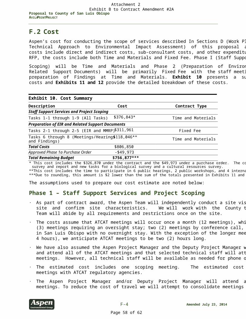
Proposal to County of San Luis Obispo AVILA POINT PROJECT
F-4 Amended July 23, 2014
F.2 Cost Aspen’s cost for conducting the scope of services described In Sections D (Work Plan) and E (Proposed Technical Approach to Environmental Impact Assessment) of this proposal are presented herein. The costs include direct and indirect costs, sub-consultant costs, and other expenditures. As identified in the RFP, the costs include both Time and Materials and Fixed Fee. Phase I (Staff Support Service and Project Scoping) will be Time and Materials and Phase 2 (Preparation of Environmental Impact Report and Related Support Documents) will be primarily Fixed Fee with the staff meetings, public hearings, and preparation of Findings at Time and Materials. Exhibit 10 presents a summary of Aspen’s estimated costs and Exhibits 11 and 12 provide the detailed breakdown of these costs. Exhibit 10. Cost Summary
Description Cost Contract Type Staff Support Services and Project Scoping Tasks 1-1 through 1-9 (All Tasks) $376,843* Time and Materials Preparation of EIR and Related Support Documents Tasks 2-1 through 2-5 (EIR and MMRP) $311,961 Fixed Fee Tasks 6 through 8 (Meetings/Hearings and Findings)
$118,046** Time and Materials Total Costs $806,850 Approved Phase 1a Purchase Order -$49,973 Total Remaining Budget $756,877*** * This cost includes the $326,870 under the contract and the $49,973 under a purchase order. The cost also includes the Peregrine Falcon
survey and report and new tasks for a biological survey and a cultural resources survey. **This cost includes the time to participate in 6 public hearings, 2 public workshops, and 4 internal meetings with the County. ***Due to rounding, this amount is $2 lower than the sum of the totals presented in Exhibits 11 and 12.
The assumptions used to prepare our cost estimate are noted below:
Phase 1 – Staff Support Services and Project Scoping
· As part of contract award, the Aspen Team will independently conduct a site visit to evaluate the site and confirm site characteristics. We will work with the County to set this up and the Aspen Team will abide by all requirements and restrictions once on the site.
· The costs assume that ATCAT meetings will occur once a month (12 meetings), which includes three (3) meetings requiring an oversight stay; two (2) meetings by conference call, and four (4) meetings in San Luis Obispo with no overnight stay. With the exception of the longer meetings (3 meetings at 4 hours), we anticipate ATCAT meetings to be two (2) hours long.
· We have also assumed the Aspen Project Manager and the Deputy Project Manager will participate and attend all of the ATCAT meetings and that selected technical staff will attend four (4) of these meetings. However, all technical staff will be available as needed for phone or web-based meetings.
· The estimated cost includes one scoping meeting. The estimated cost also includes up to four meetings with ATCAT regulatory agencies.
· The Aspen Project Manager and/or Deputy Project Manager will attend all of the internal staff meetings. To reduce the cost of travel we will attempt to consolidate meetings as shown in Exhibit
Attachment 2 Exhibit B to Contract Amendment #2A
Page 58 of 62
Proposal to County of San Luis Obispo AVILA POINT PROJECT
Amended July 23, 2014 F-5
9. However, Aspen is readily available and willing to attend meetings on short notice or we can rely on our team member PMC, who has a local office in San Luis Obispo.
· The RFP does not identify a number of desired copies of the Initial Study/Notice of Preparation. Therefore, the cost accounts for 5 copies of the Initial Study/Notice of Preparation (similar to the number of copies identified for the Project Description, approximately 75 pages)) for distribution by the County.
· The cost includes participation of an Aspen Cultural Resources specialist in all of the Native American Consultations meetings in addition to the attendance of our subcontractor who will spearhead the consultation process.
· The cost estimate for Task 1-8 (Biological Survey) includes five days of fieldwork over two survey periods. The first survey will be conducted in May 2014 and the second survey will occur in July 2014 (may be earlier or later depending on site conditions). Each survey will be conducted by a botanist and wildlife biologist. The cost also includes GIS processing and vegetation mapping.
· The cost estimate for Task 1-9 (Cultural Resources Survey) includes a focused field survey of up to 40
acres and documentation of up to 18 historic site features, which is expected to be completed in five days by a three-person crew. Æ will respond to two rounds of comments on the technical report. Prior to submittal of the report to the County, Aspen will review an initial draft of the report, provide Æ with comments, and Æ will revise the report based on Aspen's comments. Æ will also revise the report based on comments from the County.
· Based on our current understanding of Mr. Gibson’s recommendations and Native American input
to date, we anticipate that all archaeological and historical resources in the project area will be judged significant, including both in situ and displaced cultural material. Should additional effort be required to evaluate resource significance, prepare data recovery plans, or conduct other studies not currently anticipated, Aspen will be available to provide these services under a separate scope of work.
Phase 2 – Preparation of Environmental Impact Report and Related Support Documents · Per the County's stated goal in the RFP, the "hard copy" component of Administrative Draft, Draft,
Administrative Final and Final EIRs will be limited to 200 pages with all additional information presented as technical appendices on CD.
· Aspen will make maximum use of available applicant reports and other applicable environmental reports or planning documents to prepare the plan amendments, detailed project description, and the EIR. Aspen has conducted a preliminary review of available materials.
· Our cost includes participation of our Project Manager and Deputy Project Manager at six (6) public hearings. Based on our experience with other projects in the County, we have assumed that our specialized technical staff will participate in two hearings.
· Costs assume reproduction of five (5) copies of the Screencheck Draft, 45 copies of the Draft EIR, and 55 copies of the Final EIR (combination of hard copies and electronic version as required by the RFP). Additional copies can be made with a budget amendment.
Attachment 2 Exhibit B to Contract Amendment #2A
Page 59 of 62
Proposal to County of San Luis Obispo AVILA POINT PROJECT
F-6 Amended July 23, 2014
· Aspen anticipates that the CDs will be burned "in house" and that the "hard copy" documents will be produced by an outside service (Blair Graphics) and shipped to the County for distribution. Should the County wish for Aspen to distribute the documents and CDs directly, we would be more than happy to do so with a commensurate scope and cost modification.
· Consistent with the RFP, the cost for preparation of the Findings of Fact only includes 50 hours of staff time. The cost assumes that two unbound copies and one electronic copy of the Findings of Fact will be submitted to the County.
Attachment 2 Exhibit B to Contract Amendment #2A
Page 60 of 62
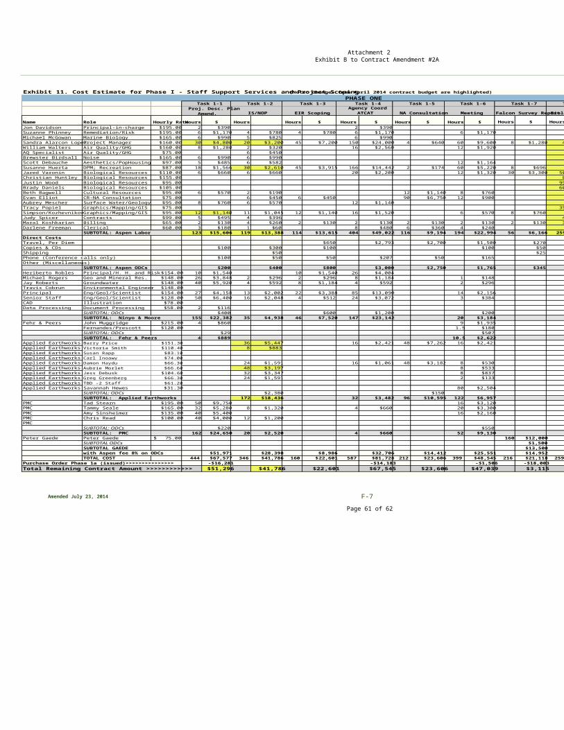
Amended July 23, 2014 F-7
Exhibit 11. Cost Estimate for Phase I - Staff Support Services and Project Scoping (Note: Changes from April 2014 contract budget are highlighted)
Name Role Hourly RateHours $ Hours Hours $ Hours $ Hours $ Hours $ Hours $ HoursJon Davidson Principal-in-charge $195.00 2 $390 2 $390Suzanne Phinney Remediation/Risk $195.00 6 $1,170 4 $780 4 $780 6 $1,170 6 $1,170Michael McGowan Marine Biology $165.00 6 $990 5 $825 6 $990Sandra Alarcon Lopez Project Manager $160.00 30 $4,800 20 $3,200 45 $7,200 150 $24,000 4 $640 60 $9,600 8 $1,280 4William Walters Air Quality/GHG $160.00 8 $1,280 2 $320 16 $2,560 12 $1,920AQ Specialist Air Quality/GHG $75.00 6 $450Brewster Birdsall Noise $165.00 6 $990 6 $990Scott Debauche Aesthetics/PopHousing $97.00 5 $485 6 $582 12 $1,164Susanne Huerta DPM; Recreation $87.00 18 $1,566 30 $2,610 45 $3,915 166 $14,442 2 $174 60 $5,220 8 $696Jared Varonin Biological Resources $110.00 6 $660 6 $660 20 $2,200 12 $1,320 30 $3,300 50Christian Huntley Biological Resources $155.00 8Justin Wood Biological Resources $95.00 95Brady Daniels Biological Resources $105.00 60Beth Bagwell Cultural Resources $95.00 6 $570 2 $190 12 $1,140 8 $760Evan Elliot CR-NA Consultation $75.00 6 $450 6 $450 90 $6,750 12 $900Aubrey Mescher Surface Water/Geology $95.00 8 $760 6 $570 12 $1,140Tracy Popiel Graphics/Mapping/GIS $75.00 35Simpson/KozhevnikovGraphics/Mapping/GIS $95.00 12 $1,140 11 $1,045 12 $1,140 16 $1,520 6 $570 8 $760Judy Spicer Contracts $99.00 5 $495 4 $396 4Maral Koshkarian Billing $65.00 2 $130 4 $260 2 $130 2 $130 2 $130 2 $130 2 $130 3Darlene Freeman Clerical $60.00 3 $180 1 $60 8 $480 6 $360 4 $240
SUBTOTAL: Aspen Labor 123 $15,606 119 $13,388 114 $13,615 404 $49,022 116 $9,194 194 $22,994 56 $6,166 259Direct CostsTravel, Per Diem $650 $2,793 $2,700 $1,500 $270Copies & CDs $100 $300 $100 $100 $50Shipping $50 $25Phone (Conference calls only) $100 $50 $50 $207 $50 $165Other (Miscellaneous)
SUBTOTAL: Aspen ODCs $200 $400 $800 $3,000 $2,750 $1,765 $345Heriberto Robles Principal/H. H. and Risk $154.00 10 $1,540 10 $1,540 26 $4,004Michael Rogers Geo and Mineral Res. $148.00 26 $3,848 2 $296 2 $296 8 $1,184 1 $148Jay Roberts Groundwater $148.00 40 $5,920 4 $592 8 $1,184 4 $592 2 $296Travis Cobrun Environmental Engineer $148.00Principal Eng/Geol/Scientist $154.00 27 $4,158 13 $2,002 22 $3,388 85 $13,090 14 $2,156Senior Staff Eng/Geol/Scientist $128.00 50 $6,400 16 $2,048 4 $512 24 $3,072 3 $384CAD Illustration $78.00Data Processing Document Processing $58.00 2 $116
SUBTOTAL: ODCs $400 $600 $1,200 $200SUBTOTAL: Ninyo & Moore 155 $22,382 35 $4,938 46 $7,520 147 $23,142 20 $3,184
Fehr & Peers John Muggridge $215.00 4 $860 9 $1,935 Fernandes/Prescott $120.00 1.5 $180
SUBTOTAL: ODCs $29 $507SUBTOTAL: Fehr & Peers 4 $889 10.5 $2,622
Applied Earthworks Barry Price $151.30 36 $5,447 16 $2,421 48 $7,262 16 $2,421Applied Earthworks Victoria Smith $110.40 8 $883Applied Earthworks Susan Rapp $83.10Applied Earthworks Carl Inoawy $74.00Applied Earthworks Damon Haydu $66.30 24 $1,591 16 $1,061 48 $3,182 8 $530Applied Earthworks Aubrie Morlet $66.60 48 $3,197 8 $533Applied Earthworks Jess Debusk $104.60 32 $3,347 8 $837Applied Earthworks Greg Greenberg $66.30 24 $1,591 2 $133Applied Earthworks TBD -2 Staff $61.20Applied Earthworks Savannah Hewes $31.30 80 $2,504
SUBTOTAL: ODCs $2,380 $150SUBTOTAL: Applied Earthworks 172 $18,436 32 $3,482 96 $10,595 122 $6,957
PMC Tad Stearn $195.00 50 $9,750 16 $3,120PMC Tammy Seale $165.00 32 $5,280 8 $1,320 4 $660 20 $3,300PMC Amy Sinsheimer $135.00 40 $5,400 16 $2,160PMC Chris Read $100.00 40 $4,000 12 $1,200PMC
SUBTOTAL: ODCs $220 $550SUBTOTAL: PMC 162 $24,650 20 $2,520 4 $660 52 $9,130
Peter Gaede Peter Gaede 75.00$ 160 $12,000SUBTOTAL ODCs $1,500SUBTOTAL GAEDE $13,500with Aspen fee 8% on ODCs $51,971 $28,398 $8,986 $32,706 $14,412 $25,551 $14,952TOTAL COST 444 $67,577 346 $41,786 160 $22,601 587 $81,728 212 $23,606 399 $48,545 216 $21,118 259
Purchase Order Phase 1a (issued)>>>>>>>>>>>>>>> -$16,281 -$14,183 -$1,506 -$18,003Total Remaining Contract Amount >>>>>>>>>>>> $51,296 $41,786 $22,601 $67,545 $23,606 $47,039 $3,115
Proj. Desc. Plan Amend.
Task 1-2
IS/NOPAgency Coord
ATCAT
Task 1-7
Falcon Survey ReportNA Consultation Meeting
Task 1-5 Task 1-6 Task 1-8
Biological Surveys
PHASE ONETask 1-3
EIR Scoping
Task 1-4Task 1-1
Attachment 2 Exhibit B to Contract Amendment #2A
Page 61 of 62
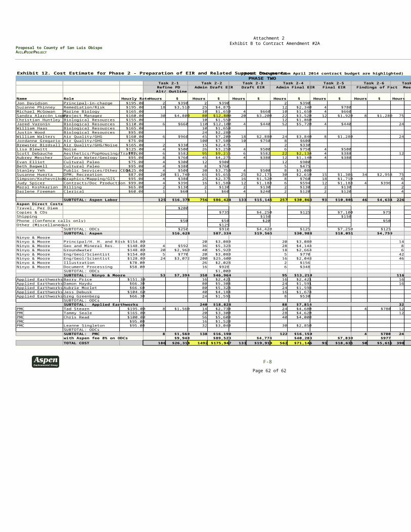
Proposal to County of San Luis Obispo AVILA POINT PROJECT
F-8
Exhibit 12. Cost Estimate for Phase 2 - Preparation of EIR and Related Support Documents (Note: Changes from April 2014 contract budget are highlighted)
Name Role Hourly Rate Hours $ Hours $ Hours $ Hours $ Hours $ Hours $ HoursJon Davidson Principal-in-charge $195.00 2 $390 2 $390 2 $390Suzanne Phinney Remediation/Risk $195.00 18 $3,510 25 $4,875 12 $2,340 4 $780Michael McGowan Marine Biology $165.00 10 $1,650 4 $660 10 $1,650 4 $660Sandra Alarcón LopezProject Manager $160.00 30 $4,800 80 $12,800 20 $3,200 22 $3,520 12 $1,920 8 $1,280 75Christian Huntley Biological Resources $155.00 10 $1,550 12 $1,860Jared Varonin Biological Resources $110.00 6 $660 110 $12,100 4 $440 52 $5,720 4 $440 24William Haas Biological Resources $165.00 10 $1,650Justin Wood Biological Resources $95.00 24 $2,280William Walters Air Quality/GHG $160.00 6 $960 45 $7,200 18 $2,880 24 $3,840 8 $1,280 24Jordanne Gregario Air Quality/GHG $75.00 100 $7,500 10 $750 8 $600Brewster Birdsall Air Quality/GHG/Noise $165.00 2 $330 15 $2,475 2 $330Lisa Blewitt Noise $125.00 4 $500 26 $3,250 4 $500 6 $750 4 $500Scott Debauche Aesthetics/PopHousing/Traffic $97.00 6 $582 95 $9,215 6 $582 22 $2,134 4 $388 12Aubrey Mescher Surface Water/Geology $95.00 8 $760 45 $4,275 4 $380 12 $1,140 4 $380Evan Elliot Cultural Paleo $75.00 4 $300 12 $900 12 $900Beth Bagwell Cultural Paleo $95.00 4 $380 8 $760 5 $475Stanley Yeh Public Services/Other CEQA $125.00 4 $500 30 $3,750 4 $500 8 $1,000Susanne Huerta DPM; Recreation $87.00 20 $1,740 65 $5,655 25 $2,175 30 $2,610 15 $1,305 34 $2,958 75Simpson/KozhevnikovGraphics/Mapping/GIS $95.00 4 $380 25 $2,375 16 $1,520 8 $760 18 $1,710 6Judy Spicer Contracts/Doc Production $99.00 4 $396 16 $1,584 12 $1,188 6 $594 12 $1,188 4 $396 4Maral Koshkarian Billing $65.00 2 $130 2 $130 2 $130 2 $130 2 $130 2Darlene Freeman Clerical $60.00 1 $60 1 $60 4 $240 2 $120 2 $120 4
SUBTOTAL: Aspen Labor 125 $16,378 756 $86,424 133 $15,145 257 $30,863 93 $10,801 46 $4,634 226Aspen Direct CostsTravel, Per Diem $200Copies & CDs $735 $4,250 $125 $7,100 $75Shipping $150 $150Phone (Confence calls only) $50 $50 $20 $50Other (Miscellaneous) $125
SUBTOTAL: ODCs $250 $910 $4,420 $125 $7,250 $125SUBTOTAL: Aspen $16,628 $87,334 $19,565 $30,988 $18,051 $4,759
Ninyo & Moore Ninyo & Moore Principal/H. H. and Risk $154.00 20 $3,080 20 $3,080 14Ninyo & Moore Geo and Mineral Res. $148.00 4 $592 36 $5,328 28 $4,144 8Ninyo & Moore Groundwater $148.00 20 $2,960 40 $5,920 18 $2,664 6Ninyo & Moore Eng/Geol/Scientist $154.00 5 $770 20 $3,080 5 $770 42Ninyo & Moore Eng/Geol/Scientist $128.00 24 $3,072 200 $25,600 16 $2,048 46Ninyo & Moore Illustration $78.00 26 $2,028 2 $156Ninyo & Moore Document Processing $58.00 16 $928 6 $348
SUBTOTAL: ODCs $1,000SUBTOTAL: Ninyo & Moore 53 $7,394 358 $46,964 95 $13,210 116
Applied Earthworks Barry Price $151.30 16 $2,421 16 $2,421 16Applied Earthworks Damon Haydu $66.30 80 $5,304 24 $1,591 16Applied Earthworks Aubrie Morlet $66.60 80 $5,328 24 $1,598Applied Earthworks Jess Debusk $104.60 40 $4,184 16 $1,674Applied Earthworks Greg Greenberg $66.30 24 $1,591 8 $530
SUBTOTAL: ODCsSUBTOTAL: Applied Earthworks 240 $18,828 88 $7,814 32
PMC Tad Stearn $195.00 8 $1,560 14 $2,730 24 $4,680 4 $780 12PMC Tammy Seale $165.00 20 $3,300 28 $4,620 12PMC Chris Read $100.00 56 $5,600 40 $4,000PMC $95.00 16 $1,520PMC Leanne Singleton $95.00 32 $3,040 30 $2,850
SUBTOTAL: ODCsSUBTOTAL: PMC 8 $1,560 138 $16,190 122 $16,150 4 $780 24with Aspen fee 8% on ODCs $9,940 $89,523 $4,774 $40,283 $7,830 $977TOTAL COST 186 $26,318 1492 $175,947 133 $19,919 562 $71,146 93 $18,631 50 $5,611 398
MeetingsRefine PDAlt/ Outline
Admin Draft EIR Draft EIR Admin Final EIR Final EIR Findings of Fact
PHASE TWOTask 2-1 Task 2-2 Task 2-3 Task 2-4 Task 2-5 Task 2-6 Task 2-7
Attachment 2 Exhibit B to Contract Amendment #2A
Page 62 of 62