Embed Size (px)
Citation preview

Appendix F Environmental Resources Analysis
APPENDIX FEnvironmental Resources Analysis
TABLE OF CONTENTS
1.1 OVERVIEW.....................................................................................................................................11.2 PROJECT AREA............................................................................................................................1
1.2.1 Upper Trinity River Watershed.............................................................................................11.2.2 The City of Dallas.................................................................................................................21.2.3 Study Area.............................................................................................................................21.2.4 Projects of Others..................................................................................................................3
1.3 EXISTING CONDITIONS...........................................................................................................131.3.1 Water Resources..................................................................................................................141.3.2 Biological Resources...........................................................................................................23
1.4 FUTURE WITHOUT-PROJECT CONDITIONS.....................................................................541.4.1 Water Resources..................................................................................................................541.4.2 Biological Resources...........................................................................................................551.4.3 Flood Risk Management Recommended Plan....................................................................59
1.5 COMPREHENSIVE ANALYSIS................................................................................................601.5.1 Balanced Vision Plan..........................................................................................................601.5.2 Interior Drainage Plan Improvements.................................................................................781.5.3 Local Features: Section 408 Projects..................................................................................841.5.4 Trinity Parkway...................................................................................................................841.5.5 Overview of Alternatives....................................................................................................851.5.6 Balanced Vision Plan..........................................................................................................851.5.7 Interior Drainage Plan.........................................................................................................871.5.8 The Modified Dallas Floodway Project..............................................................................88
1.6 ALTERNATIVES EVALUATION OF FISH AND WILDLIFE IMPACTS..........................971.6.1 Alternative 2 - Proposed Action with Parkway - Changes to Habitat Acreages.................971.6.2 Alternative 2 – Proposed Action Without Parkway - Changes To Habitat Acreages.......109
1.7 MODIFIED DALLAS FLOODWAY PROJECT - CHANGES TO HABITAT ACREAGES AND HABITAT UNITS OVER THE 50-YEAR PERIOD OF ANALYSIS...117
1.7.1 Revisions to Habitat Acreages and Habitat Units Over the 50-Year Period of AnalysisDue to Additional Screening for the Modified Dallas Floodway Project.........................125
1.7.2 Modified Dallas Floodway Project - Threatened and Endangered Species and Birds of Conservation Concern.......................................................................................................130
1.7.3 Modified Dallas Floodway Project – Habitat Units and Average Annual Habitat Units Summary...........................................................................................................................130
1.7.4 Modified Dallas Floodway Project – Elements Selection Discussion..............................1301.7.5 Modified Dallas Floodway Project – National and Regional Significance.......................132
1.8 ENVIRONMENTAL MITIGATION ANALYSIS...................................................................1351.8.1 Modified Dallas Floodway Project Environmental Mitigation Analysis Results.............1351.8.2 Environmental Mitigation Analysis for Remaining BVP/IDP Elements..........................1361.8.3 USFWS Recommendations...............................................................................................1361.8.4 Monitoring and Adaptive Management Plan....................................................................137
1.9 REFERENCES............................................................................................................................138
1
2
3
4
5
678910
111213
14151617
181920212223242526
27282930
313233343536373839
4041424344

Appendix F Environmental Resources Analysis

Appendix F Environmental Resources Analysis
List of Figures
F-1 Dallas Floodway Project Study Area................................................................................................4F-2 Location of Cumulative Projects......................................................................................................5F-3 Surface Water Features in the Dallas Floodway.............................................................................17F-4 Existing Habitat Types in the ROI for Biological Resources.........................................................29F-5 Habitat Evaluation Procedure Data Points and Evaluation Groups in the Biological
Resources Study Area.....................................................................................................................33F-6 Habitat Types Under the Future Without-Project Conditions........................................................39F-7 Overview of Proposed BVP Study Ecosystem and Recreation Features.......................................63F-8 Proposed BVP Study Ecosystem and Recreation Features: Northern Segment.............................65F-9 Proposed BVP Study Ecosystem and Recreation Features: Middle Segment................................67F-10 Proposed BVP Study Ecosystem and Recreation Features: Southern Segment.............................69F-11 Proposed Interior Drainage Plan Improvements.............................................................................81F-12 Overview of Proposed Action with Parkway.................................................................................91F-13 Overview of Proposed Action without Parkway............................................................................95F-14 Habitat Types Under Alternative 2 - Proposed Action with Parkway............................................99F-15 Habitat Types Under Alternative 2 - Proposed Action without Parkway.....................................111F-16 Modified Dallas Floodway Project...............................................................................................119
List of Tables
F-1 2010 Level of Use and Support for Designated Uses and Assessment Unit Category and Status on 2010 303(d) List..............................................................................................................21
F-2 Summary of Existing Water Quality Conditions in the Trinity River............................................23F-3 Habitat Types and Associated Acreages in the Biological Resources Study Area........................32F-4 Habitat Evaluation Groups by Habitat Types in the Biological Resources Study Area.................32F-5 Bottomland Hardwood, Emergent Wetland, and Grassland Habitat Acreages, Habitat
Suitability Indices, and Habitat Units in the Biological Resources Study Area.............................37F-6 Aquatic Riverine and Open Water Habitat Acreages, Habitat Suitability Indices, and
Habitat Units in the Biological Resources Study Area...................................................................38F-7 Qualitative Habitat Values for Areas in the Biological Resources Study Area..............................38F-8 Bird Species Observed in the Trinity River Floodplain.................................................................42F-9 Bird Species Observed in the Interior Drainage System (September 2009)...................................43F-10 Dallas County Federal and State Threatened and Endangered Species..........................................45F-11 Dallas County Species of Concern.................................................................................................51F-12 Future Without-Project HU Calculations by Habitat Evaluation Group........................................57F-13 Summary of Habitat Units per Habitat Type Within the Study Area under the Future
Without-Project Conditions............................................................................................................59F-14 Permanent Environmental Impacts – Levee Raise and Seepage Wall Alternatives.......................60F-15 Summary of BVP Elements............................................................................................................61F-16 Summary of Interior Drainage Outfall Channel Changes..............................................................78F-17 Summary of Interior Drainage Plan Improvements........................................................................79

Appendix F Environmental Resources Analysis
F-18 BVP and IDP Features and the Modified Dallas Floodway Project...............................................88F-19 Summary and Comparison of Impacts for Alternatives 1 and 2 under both the With
Parkway or Without Parkway Future Conditions...........................................................................93F-20 Estimated Changes in Habitat Acreages in the Confluence Group over the Next 50 Years
for Existing, Future Without, and Proposed Action with Parkway................................................97F-21 Estimated Changes in Habitat Acreages for the Mainstem Group over the Next 50 Years
for Existing, Future Without, and Proposed Action with Parkway..............................................101F-22 Estimated Changes in Habitat Acreages in the Interior Drainage Systems Group over the
Next 50 Years for Existing, Future Without, and Proposed Action with Parkway......................103F-23 Estimated HSIs, Acreages, and HUs for Habitat Types in the Confluence Group over the
Next 50 Years for Existing, Future Without, and Proposed Action with Parkway......................104F-24 Estimated HSIs, Acreages, and Habitat Units for Habitat Types in the Mainstem Group
over the Next 50 Years for Existing, Future Without, and Proposed Action with Parkway........105F-25 Estimated Habitat Suitability Indices, Acreages, and Habitat Units for Habitat Types in
the Interior Drainage Systems Group over the Next 50 Years for Existing, Future Without, and Proposed Action with Parkway...............................................................................107
F-26 HUs per Habitat Type Within the Study Area for Existing, Future Without, and Proposed Action with Parkway....................................................................................................................108
F-27 Estimated HU Values for Habitats within the Study Area for Future Without and Proposed Action with Parkway (Year 50)....................................................................................108
F-28 Estimated Changes in Habitat Acreages for the Mainstem Group over the Next 50 Years for Existing, Future Without, and Proposed Action without Parkway.........................................110
F-29 Estimated HSIs, Acreages, and Habitat Units for Habitat Types in the Mainstem Group over the Next 50 Years for Existing, Future Without, and Proposed Action Without Parkway........................................................................................................................................114
F-30 HUs per Habitat Type Within the Study Area for Existing, Future Without, and Proposed Action Without Parkway..............................................................................................................116
F-31 Estimated HU Values for Habitats within the Study Area for Future Without-Project Conditions and Alternative 2 - Proposed Action Without Parkway (Year 50)............................116
F-32 Estimated Changes to Habitat Acreages within the Study Area under Modified Dallas Floodway Project at Year 50........................................................................................................118
F-33 HUs per Habitat Type Within the Study Area under Modified Dallas Floodway Project at Year 50..........................................................................................................................................121
F-34 Estimated HU Values for Habitats within the Study Area under Baseline and Modified Dallas Floodway Project (Year 50)..............................................................................................122
F-35 Estimated AAHU Values for Habitats within the Study Area under Baseline and Modified Dallas Floodway Project...............................................................................................124
F-36 Revised Changes to Habitat Acreages within the Study Area under Modified Dallas Floodway Project at Year 50........................................................................................................126
F-37 Revised HUs per Habitat Type Within the Study Area under Modified Dallas Floodway Project at Year 50.........................................................................................................................127
F-38 Revised Estimated HU Values for Habitats within the Study Area under Baseline and Modified Dallas Floodway Project (Year 50)...............................................................................128
F-39 Revised Estimated AAHU Values for Habitats within the Study Area under Baseline and Modified Dallas Floodway Project...............................................................................................129

Appendix F Environmental Resources Analysis
This Page Intentionally Left Blank.

Appendix F Environmental Resources Analysis
1.1 OVERVIEWThe purpose of this appendix is to describe the habitat assessment efforts and subsequent environmental analysis results for Existing Conditions, Future Without-Project Conditions, and the projected Future With-Project Conditions for the alternatives analyzed as part of this study. The “No Action” alternative is the same as Future Without-Project habitat conditions. The evaluation of these conditions serves as the environmental acceptability analysis that was undertaken as part of this study. If an action is “environmentally acceptable,” it means the action has been determined to be acceptable through the application of the National Environmental Policy Act (NEPA) process, is documented in the Record of Decision (ROD), and meets other environmental laws and regulations. An Environmental Impact Statement (EIS) has been prepared, which documents the environmental impacts associated with implementation of the project alternatives and identifies a recommended plan.
1.2 PROJECT AREA1.2.1 Upper Trinity River Watershed
The Trinity River is a perennial river that is 715-miles long and flows entirely within the state of Texas. The river’s original name, La Santisma Trinidad (the Most Holy Trinity), is derived from the convergence of the two branches of the Trinity River which come together in the City of Dallas. The Trinity River Basin is bound on the north by the Red River Basin, on the east by the Neches and Sabine River Basins, on the west by the Brazos River Basin and on the south by the San Jacinto Basin. The basin has an overall length of about 360 miles and a maximum width in the headwaters of about 100 miles. It extends along a northwest-southeast axis from Archer County to the northwest to Chambers County and continues in a southeasterly direction until it empties into the Gulf of Mexico at Trinity Bay near Galveston.
The Trinity River has been designated a navigable waterway by the United States (U.S.) Coast Guard in accordance with 33 Code of Federal Regulations (CFR) Section 2.05-25, Navigable Waters of the U.S. Accordingly, the Trinity River is regulated under Sections 9 and 10 of the Rivers and Harbors Act of 1899, and under the General Bridge Act of 1946. Navigation and flood damage reduction improvements on the Trinity River were authorized pursuant to the Rivers and Harbors Act of 1965 (Public Law 89-298), as part of the earlier Trinity River Project. As authorized, the Trinity River Project consisted of 5 major components, one of which included the construction of a 12-foot by 200-foot multi-purpose navigation channel along the river with 20 locks and dams from the Houston Ship Channel to the City of Fort Worth. Currently, the only portion of that navigation plan still in existence is a deepening and widening of the channel from the Houston Ship Channel to River Mile 45 above Liberty, Texas in the lower basin. Components of the Channel to Liberty, as it is called, were constructed under previous authorizations and, at this time, there is no plan to widen or deepen the channel to the width and depth authorized in the 1965.
The area hydrologically modeled in the current study consists of the entire drainage area of the Trinity River, from its headwaters to the confluence of Five Mile Creek near the Interstate Highway (IH)-20 Bridge in south Dallas, an area commonly referred to as the Upper Trinity River watershed. The Upper Trinity River watershed covers roughly 6,275 square miles and is composed of four branches, the Clear, West, Elm, and East Forks. The headwaters of each are located north and west of Dallas and Fort Worth and converge within the Metroplex. Specifically, the main stem of the Trinity River is formed in Dallas by the confluence of the West Fork and Elm Fork. The West Fork extends approximately 209 miles from
F-1
12345678910
1112131415161718
19202122232425262728293031
32333435363738

Appendix F Environmental Resources Analysis
Archer County and flows in a southeasterly direction to the City of Fort Worth where it is joined by the Clear Fork. The river continues in an easterly direction another 53 miles to its junction with the Elm Fork in Dallas. The Elm Fork rises in Montague County and flows in a southeasterly direction to join the West Fork and form the Trinity River at Dallas. The East Fork, although not specifically within the Study Area, rises in Grayson County from the northeast and flows southward to join the Trinity River 20 miles southeast of Dallas.
Within the Upper Trinity River watershed, the river is influenced by more than 2,500 minor flow-retarding structures and 12 major reservoirs. Five of these are U.S. Army Corps of Engineers (USACE) flood control reservoirs, of which three (Lakes Benbrook, Lewisville and Grapevine) were impounded in the early 1950s. Impoundments in the other two (i.e., Lakes Joe Pool and Ray Roberts) were initiated in January 1986 and June 1987, respectively.
The two largest non-federal reservoirs in the Upper Trinity River watershed, both of which are located on the West Fork of the Trinity River, are Lake Bridgeport and Eagle Mountain Lake. Lake Bridgeport is located just west of the City of Bridgeport in Wise County. Eagle Mountain Lake is located in northwestern Tarrant County, just upstream from the much smaller Lake Worth, which is owned by the City of Fort Worth. Smaller lakes with the watershed include: Lake Amon Carter, located on Big Sandy Creek south of Bowie in southwestern Montague County; Lake Weatherford, located on the Clear Fork of the Trinity River northeast of Weatherford in Parker County; Lake Arlington, located in western Arlington in Tarrant County; and Mountain Creek Lake, located on its namesake in western Dallas County.
Terrain in this watershed varies in elevation from about 1,200 feet National Geodetic Vertical Datum (NGVD) at the headwaters of the West Fork of the Trinity River just northeast of Olney, Texas, to about 380 feet NGVD at the confluence of Five Mile Creek.
1.2.2 The City of Dallas
The City of Dallas is located in Dallas County in north central Texas, approximately 35 miles east of Fort Worth and 245 miles north-northeast of Houston. Dallas has expanded to become a highly diversified city since its incorporation in 1846. The city’s economy is primarily based on banking, commerce, computer technology, telecommunications, energy, healthcare and medical research, transportation and logistics.
With its centralized location, the convergence of four major north/south and east/west interstate highways, and the presence of Dallas/Fort Worth International Airport (DFW), Dallas is the main core for the largest inland metropolitan area in the U.S. without a navigation link. The city attracts worldwide travelers, making the area the number one visitor and leisure destination in Texas, and the third most popular destination for business travel in the U.S.
With an estimated 2012 population of 1,241,162, the City of Dallas is the third largest city in Texas and the ninth largest city in the U.S. As of 2010, the estimated population within the Study Area was 112,083 (U.S. Census Bureau 2011).
1.2.3 Study Area
Located in the Upper Trinity River watershed, the Dallas Floodway Levee System (Dallas Floodway) is the focus area for this feasibility study. The Dallas Floodway is a major USACE flood control project located along the Trinity River in Dallas, Texas, which was designed to divert floodwaters away from approximately 10,000 acres of residential and highly developed commercial and industrial property
F-2
123456
7891011
121314151617181920
212223
2425262728
2930313233
343536
37383940

Appendix F Environmental Resources Analysis
within the City of Dallas. The levee system extends along the Trinity River upstream from Trinity River Mile 497.37 (approximately the Atchison, Topeka and Santa Fe [AT&SF] Railroad Bridge), to the confluence of the West and Elm Forks at River Mile 505.50, then upstream along the West Fork for approximately 2.2 miles and upstream along the Elm Fork approximately 4 miles. There are 22.6 miles of levees in the Study Area, with the East Levee being 11.7 miles in length while the West Levee is 10.9 miles in length. In addition to the levees, the Dallas Floodway includes the current and remnant river channels, 6 pumping stations, 7 pressure sewers, and 3 gravity sluices.
The boundaries of the defined study can generally be defined as the region encompassed by the Trinity River Corridor Comprehensive Land Use Plan (TRCCLUP), adopted by the Dallas City Council in March 2005 (Figure F-1). The TRCCLUP serves as a framework for implementing a coordinated approach to infrastructure improvements, land use, and economic development in the Trinity River Corridor (TRC).
All but three of the environmental resources described in the Feasibility Report are discussed in context of the TRCCLUP Study Area. Only Air Quality, Hydrology and Hydraulics (H&H) and Biological Resources require analysis beyond the TRCCLUP boundaries. The Air Quality Study Area is focused on the pertinent Air Quality Control Region (AQCR), in this case the Metropolitan Dallas-Fort Worth AQCR 215, which includes a ten county area in north central Texas. The extent of the regional H&H models is described in detail in the Feasibility Report. Because of the need to be able to sufficiently characterize any potential impacts within the TRCCLUP boundaries, the H&H Study Area extends beyond the TRCCLUP boundaries both upstream and downstream. For this analysis, the Study Area for H&H has as a lower boundary the downstream limits of the Dallas Floodway Extension project at IH-20 and as upstream boundaries, beyond the limits of the Dallas Floodway East Levee near IH-35E on the Elm Fork Trinity River and beyond the limits of the Dallas Floodway West Levee near IH-30 on the West Fork Trinity River. The Biological Resources Study Area includes the area evaluated by the USFWS in the Existing Habitat Conditions Planning Aid Report (PAR) for the Dallas Floodway Project (see Appendix G) and roughly corresponds to the Federal Emergency Management Agency 500-year flood event level (U.S. Fish and Wildlife Service [USFWS] 2014a). The area includes: (1) the Confluence Group consisting of the Elm Fork and West Fork of the Trinity River; (2) the Mainstem Group consisting of the main channel of the Trinity River, the floodplain, and levees along the river; and (3) the Interior Drainage System Group and surrounding commercial and residential areas.
1.2.4 Projects of Others
This section includes a description of identified actions by other entities within the Study Area that have resulted, or may result, in changes to the environment. Projects of others that are completed, or that had started construction as of March 31, 2012 are presented in subsection 1 below, and are included in the affected environment description for each resource area in Section 1.3, Existing Conditions. Conversely, projects not started as of March 31, 2012 are presented in subsection 2 below, and are analyzed under the Future Without-Project Conditions for each resource in Section 1.4.
Figure F-2 depicts the general location of each of these projects.
F-3
1234567
891011
121314151617181920212223242526272829
303132333435
36

Appendix F Environmental Resources Analysis
Figure 8x11
F-1 Dallas Floodway Project Study Area
F-4
1
2
3
Appendix F Environmental Resources Analysis
Figure 11x17
F-2 Location of Cumulative Projects
F-5
1
2
3
4

Appendix F Environmental Resources Analysis
Back of Figure F-2
F-6
1
2
Appendix F Environmental Resources Analysis
1.2.4.1 Projects of Others Included in Existing Conditions
The following provides a summary description of the identified past and present projects.
Dallas Area Rapid Transit Orange Line
The Dallas Area Rapid Transit (DART) Orange Line light rail project is 14-miles long and connects existing DART rail lines to the Irving/Las Colinas area, ultimately providing rail service to DFW (DART 2012a). Construction, which began in 2009, reached the Las Colinas Urban Center in July 2012, and was completed with the opening of the DFW rail stop in August 2014.
Dallas Floodway Extension Project
The Dallas Floodway Extension project consists of the following major components: construction of the Chain of Wetlands, the Cadillac Heights and Rochester Park Levees, and ecosystem and recreation features immediately downstream of the existing Dallas Floodway Levee System. The project area covers approximately 9,500 acres. Construction of the Dallas Floodway Extension project is on-going (USACE 2012a).
Dallas Wave
This project includes the construction of an in-stream standing wave for recreational use, and covers approximately nine acres. In addition to the in-stream component, the standing wave includes a shore component consisting of a canoe launch, trails, a parking area, and ingress/egress points (launch and take-out) supported by retaining walls. The initial construction was completed in 2012; additional improvements are under design consideration (City of Dallas 2012a).
Elm Fork Athletic Complex
The Elm Fork Flood Athletic Complex project includes enacting flood protection improvements, recreation facilities, and environmental restoration in the Elm Fork area. Of note, the project will feature 19 soccer fields and 1 championship field in an athletic complex, a dog park, trails, and associated amenities (City of Dallas 2012a). Construction began in August 2011 and the Complex opened in April 2014.
Great Trinity Forest Land Acquisition and Trails
The Great Trinity Forest Master Plan Concept, approved by the Dallas City Council on March 26, 1997, proposed the development of multipurpose trails for recreation, education, and transportation. It also outlined the acquisition and preservation of bottomland hardwood forest within the Trinity River Corridor. The project area covers 6,000 acres; land acquisition and development continues and is expected to be a long-term effort (City of Dallas 2012a).
Hampton Bridge
A new six-lane bridge was constructed to replace the existing four-lane bridge at the Hampton/Inwood crossing. The project area was approximately 28 acres and construction of this project finished in 2010 (Texas Department of Transportation [TxDOT] 2010, 2012a).
Margaret Hunt Hill Bridge
The new “signature” Margaret Hunt Hill Bridge is located between the Continental Avenue and Union Pacific Railroad bridges, connecting Singleton Boulevard in West Dallas across the Trinity River to Woodall Rodgers in downtown Dallas. This bridge is part of the proposed 10 acre Woodall Rodgers
F-7
1
2
3456
7891011
1213141516
1718192021
2223242526
272829
303132

Appendix F Environmental Resources Analysis
extension designed to relieve traffic congestion. The Margaret Hunt Hill Bridge opened to vehicular traffic in March 2012 (Dallas Morning News 2012).
Moore Gateway Park
Moore Gateway Park is a regional gateway providing access to the Dallas Floodway. Moore Gateway Park is approximately 28.5 acres and includes athletic fields, a large pavilion, and access to the Dallas Wave. Construction began January 2012 and the park was opened for public use on June 13, 2013 (City of Dallas 2012a, Trinity River Corridor Project 2013).
Oncor Transmission Line
Oncor Electric Delivery installed a new 345-kilovolt (kV) power transmission line from West Levee Switching Station located in Dallas, to the Norwood Switching Station, located in Irving. The City of Dallas and Oncor worked cooperatively to avoid routing a new line along the levees of the Trinity River and to relocate existing power transmission lines along the Trinity River. The transmission line covers almost 7 miles, 1 mile of which is underground. This project was completed in 2010 (City of Dallas 2012a).
Pavaho Pumping Plant
The City of Dallas improved the Pavaho Pumping Plant in order to reduce the potential stormwater flooding impacts to people and property in the City of Dallas and extend the service life of the existing facility for at least another 50 years. Improvements included constructing a new pump station, improving the existing Pavaho Pump Station, utilizing the two existing gravity sluices, and installing a new junction box to connect flow from the existing and new Pavaho Pump Stations. The project area was roughly four acres. Construction began in September 2010 and was completed in 2012 (USACE 2010a).
William Blair Gateway Park (formerly known as Rochester Gateway Park)
William Blair Jr. Park is a 900-acre park near US-175 that currently has a lake fishing pier and open spaces. The Trinity River Corridor Project has added a gateway and trailhead that includes expanded parking, a kiosk, seating area and a trail that goes over the levees to tie into the Bois d'arc Trail in the Great Trinity Forest. This project began in 2012 and was finished in 2012 (City of Dallas 2012a).
Santa Fe Trestle Trail
The Santa Fe Trestle Trail is a hike and bike trail providing access to Moore Park, located off East 8th Street south of downtown Dallas. It covers approximately 10 acres and crosses the Trinity River via the abandoned AT&SF Railroad Bridge and portions of the old railroad trestle, and ends as an access road at the north Trinity River levee near downtown Dallas. Construction began July 2010 and was completed in 2012 (City of Dallas 2012a).
Sylvan Avenue Bridge
The Sylvan Bridge will replace the Sylvan Avenue approaches and low water crossing over the Trinity River with a single bridge structure that will span the Dallas Floodway. The project involves the upgrade of the existing two-lane conveyance to a six-lane bridge, a left turn lane, sidewalks, and pedestrian railing along both sides of the bridge. The bridge will also include two shared-use travel lanes (one in each direction) to accommodate a bike route along the bridge, a ramp to provide access to Crow Lake Park, and the relocation of the existing boat ramp at Crow Lake Park. The project area covers approximately 15.4 acres. Construction is in process, and the estimated completion date is early 2015 (TxDOT 2010).
F-8
12
3456
789101112
131415161718
19202122
2324252627
28293031323334

Appendix F Environmental Resources Analysis
Texas Buckeye Trail
The City of Dallas added an additional 1.6 miles of hard surface trails to the Texas Buckeye Trail in 2009. The trail is located at the end of Bexar Street in Rochester Park. A three-quarter-mile spur from the trail takes visitors to a large grove of Texas Buckeye trees (Aesculus arguta) located adjacent to the Trinity River (City of Dallas 2012a).
Trinity Overlook Park
Completed in October 2008, the Trinity Overlook Part is located just south of the western approach to the Commerce Street Bridge and covers less than half an acre. The Trinity Overlook Park includes shade tents and interpretive displays providing information on the Dallas Floodway, the Trinity Lakes, and the signature bridges (City of Dallas 2012a).
Trinity River Audubon Center
The Trinity River Audubon Center is a 120 acre facility located south of South Loop 12 and east of IH-45. The Trinity River Audubon Center provides a place for presenting educational and environmental interests in the Trinity River Corridor; eco-tourism activities; aquatic, archaeological, and historical exhibits; and theme gardens at the center of the Great Trinity Forest's trail system. The Trinity River Audubon Center opened in 2008 (Trinity River Audubon Center 2012).
Trinity Trails
The Trinity Trails includes an extensive network of trails within the Trinity River Corridor with 3.5 miles of trails that are designed for environmentally sensitive areas, 7 miles of soft surface trails, and 26 miles of hard surface trails with pedestrian bridges across the Trinity River. Phase I consists of 2 miles of 12-foot wide concrete trail beginning at the Loop 12 boat launch and ending at the City of Dallas' Ecopark Facility parking lot on Simpson Stuart Road. Phase II consists of 2.5 miles of concrete trail beginning at the end of Phase I on Simpson Stuart Road and ending at the Trinity River Audubon Center. All construction will be completed by December 2013 (Trinity Strand Trail 2013).
1.2.4.2 Future Projects of Others
The following projects started construction after March 31, 2012, are in early design or undergoing environmental analysis and are considered part of the Future Without-Project Conditions.
Able Pumping Plant
The City of Dallas and the USACE are planning to relocate and improve the Able Pumping Plant in order reduce the potential for stormwater flooding impacts to people and property in the Able Basin. The Proposed Action consists of constructing a new 875,000-gpm capacity pump station and outfall, and decommissioning and removing the existing Small Able and Large Able pump stations. The new Able Pumping Plant would be located near the existing Bellevue Pressure Sewer, adjacent to Riverfront Boulevard near the east levee. In addition, the Proposed Action includes implementing stormwater conveyance improvements in the Able Sump ponds (HDR 2013). The USACE completed an Environmental Assessment for the proposed improvements to the Able Pumping Plant and the City of Dallas awarded a construction contract in August 2014 (USACE 2014b, City of Dallas 2014).
Baker Pumping Plant
The City of Dallas and USACE are planning to improve the Baker Pumping Plant in order to reduce the potential stormwater flooding impacts to people and property in the City of Dallas and extend the service life of existing facilities for at least another 50 years. Improvements would include constructing a new
F-9
1234
5678
910111213
14151617181920
21
2223
242526272829303132
333435

Appendix F Environmental Resources Analysis
pump station (which would work along with the 1975 Baker Pump Station), rehabilitating the Baker Pump Station to modernize the electrical system of the building, and decommissioning the Old Baker Pumping Plant. The project area is approximately 4.5 acres. The USACE prepared an Environmental Assessment for this action and the Finding of No Significant Impact was signed in 2012 (USACE 2012b). Construction began in 2013 and the Pump Station is slated to open in February 2015 (City of Dallas 2014).
Beckley Avenue Improvements
The City of Dallas plans to improve Beckley Avenue at Commerce Street by adding four new vehicle lanes, reinforced concrete sidewalks, a new major drainage system, and upgraded water and wastewater mains. The project area will cover approximately 3 acres. Construction is estimated to conclude in fall 2014 (City of Dallas 2012a).
Belleview Trail Connector
The City of Dallas proposes to construct a trail connecting development, entertainment, and art districts via mass transit in the Cedars District. The trail would be slightly less than one acre and would connect the proposed Trinity Park to the DART Cedars Station. This project does not currently have an estimated start date (City of Dallas 2012a).
Bernal Trail
The City of Dallas would extend the existing Bernal Trail to link the Westmoreland Heights area to the Trinity Levee Trail along the West Levee. The trail would go from Emma Carter Park to Tipton Park, and would cover approximately 4.6 acres. This project currently has no funding for construction and does not have an estimated start date (City of Dallas 2012a).
Continental Pedestrian Bridge
The existing Continental Avenue Bridge would be converted from vehicular to pedestrian and bicycle use. The vehicle to pedestrian conversion and associated ancillary elements would cover 4.6 acres. The project opened in June 2014 (City of Dallas 2014).
Dallas Maritime Museum
The Dallas Maritime Museum is a proposed 3.5 acre museum located along the Trinity River, at 1501 Riverfront Boulevard in a currently undeveloped grassland parcel. The $80 million project is sponsored by a non-profit organization, the Dallas Maritime Museum Foundation. The museum plans to acquire and display the 362-foot USS Dallas and other vessels next to the 30,000 square-foot museum building (Dallas Morning News 2013).
Dallas Watersports Complex
The Dallas Watersports Complex would include a waterskiing cableway, a pro-shop, snack bar, full-service restaurant, and viewing deck. The Dallas Watersports Complex would be located on Fish Trap Lake at the intersection of Hampton Road and Singleton Boulevard in West Dallas, and cover approximately 42 acres. This project does not currently have an estimated start date (Dallas Watersports Complex 2012).
Dallas Water Utility Lines
The Dallas waterlines project proposes to relocate four water mains and one drainage pipeline that currently underlie the floodway and/or the levees. In addition to the relocation of the existing pipelines,
F-10
123456
78910
11121314
15161718
192021
2223242526
2728293031
3233

Appendix F Environmental Resources Analysis
the City of Dallas may also remove all or part of 3 force mains, 1 wastewater bypass main, 2 wastewater mains, and 4 water mains that have previously been abandoned and that currently underlie the floodway and/or the levees. Temporary impacts would occur from the implementation of the proposed utility lines.
EF2 Wastewater Interceptor Line and Laterals
This project consists of a new 108-inch diameter wastewater interceptor that would be installed parallel to and riverward, of an existing 90-inch diameter wastewater line located within the Dallas Floodway and immediately adjacent to the Northwest Levee in Irving. Also included in this project are four lateral wastewater lines (points of entry) that are proposed to cross beneath the levee and connect to either the existing 90-inch diameter line or the new 108-inch diameter line. The project area would be approximately 3.7 acres. The Trinity River Authority anticipates the construction period to last 2 years, beginning in late 2012 (Black & Veatch 2011).
Horseshoe Project
A subset of the larger Project Pegasus, the Horseshoe Project would replace two key bridges and connecting roadways crossing the Trinity River at IH-30 and IH-35, as well as upgrade outdated roadway geometry, improve safety, and increase capacity and mobility. The project would begin at Sylvan Avenue on IH-30, extend to the IH-30/IH-35 interchange (commonly referred to as the Mixmaster) and head south on IH-35 to cross the Trinity River, ending just south of Colorado Boulevard. The project started construction in 2013 and is expected to be completed by late 2016 (TxDOT 2012a, City of Dallas 2014).
IH-20 Gateway Park
The City of Dallas proposes to construct the IH-20 Gateway Park north of the intersection of IH-20 and Dowdy Ferry Road. The park would include picnic and fishing stations around the existing pond and canoe access to the Trinity River. The park would cover approximately 75 acres. Construction is completed and the project opened in June 2013 (City of Dallas 2014).
Irving Northwest Levee Repair
This 23-acre project would complete the rehabilitation of the Irving Northwest Levee for re-certification and re-accreditation for protection from up to and including the 100-year riverine flood event. This project consists of installing a slurry wall on the riverside toe of the existing levee (approximately 13,000 feet long and 25 feet deep) to minimize potential seepage issues associated with the levee during major flood events. It would also include the rehabilitation of a portion of the levee, by either overlaying with clay material or grouting the sand to reduce the potential for through seepage of the levee during flood events. This project is currently on hold (Halff Associates 2012).
Jefferson Memorial Bridge
The Jefferson-Memorial Bridge would replace the existing Jefferson Street Bridge; the project is currently in the planning stage at TxDOT. The new bridge would provide direct connects to and from IH-35E (TxDOT 2012b).
Joppa Gateway Park
The City of Dallas plans to construct the Joppa Gateway Park as an expansion and improvement of the existing South Central Park. The park would feature a spray ground, expanded trails, an open play field area, an additional small pavilion with picnic/barbeque stations, site furnishings, and would repair and upgrade the existing basketball court. Construction is underway (City of Dallas 2014).
F-11
123
45678910
11121314151617
18192021
22232425262728
293031
32333435

Appendix F Environmental Resources Analysis
Loop 12 Bridge
Under this project, the Loop 12 corridor near the western State Highway (SH) 183 crossing would be reconstructed to accommodate eight general-purpose lanes (plus auxiliary lanes), four continuous frontage road lanes (plus auxiliary lanes near ramp locations and cross-streets), and a reversible High-Occupancy Vehicle (HOV)/Managed facility. The project area would cover approximately 34 acres; various construction components, such as lighting, are scheduled to be implemented in 2015/2016, other construction elements are on hold pending funding (Bridgefarmer & Associates 2012, City of Dallas 2014).
Loop 12 Gateway Park
The City of Dallas proposes to construct the Loop 12 Gateway Park in a 2.15-mile long greenbelt running from the intersection of Loop 12 and IH-45, east to the Trinity River. The greenbelt would total approximately 153 acres. This project would be done in three phases. Phase 1 would enhance the entrance to the Trinity River Audubon Center (located at 6500 Great Trinity Forest Way) with an extra entry/exit lane and native landscaping. Phases 2 and 3 would add lighting to Great Trinity Forest Way and provide a large welcoming sign announcing the Great Trinity Forest. This project is currently under design and is expected to begin construction in 2013 (City of Dallas 2012b; Trinity River Corridor Project 2013).
Martin Luther King Jr. Gateway and Cedar Crest Bridge Improvements
The City of Dallas proposes to improve the existing Martin Luther King. Jr. Bridge that crosses the Trinity River, to accommodate pedestrians and bicyclists. There would also be parking added to the west side of the bridge, and access to a trail that would wind its way past the Upper Chain of Wetlands to Moore Park and the Santa Fe Trestle Trail. This project is under design (Trinity River Corridor Project 2013).
Pavaho Wetlands
The proposed Pavaho Stormwater Wetland Project would include construction of approximately 64 acres of wetlands consisting of four separate cells located near the Pavaho Pumping Plant outfall. The wetland area is intended to provide water quality improvement for storm flows collected in the sump prior to conveyance to the river by the Pavaho Pumping Plant. The primary purpose for the three wetland cells located on the river side of the West Levee would be to create diverse, high quality wetland habitat for multiple migratory and resident wildlife and bird species and to a lesser degree provide water quality improvement for stormwater runoff from the adjacent floodplain area as well as river overflows. Construction started in early 2014 (USACE 2013).
Riverfront Boulevard
This 27-acre project involves converting Riverfront Boulevard (formerly Industrial Boulevard) to a 1.5-mile, eight-lane thoroughfare with a 150-foot wide right of way. Riverfront Boulevard would become a “complete street” and include landscape zones, bicycle lanes, and pedestrian sidewalks. The project would also include an upgrade of the drainage system and replacement/upgrade of existing water and wastewater transmission and distribution lines. Phase I construction is on-going and Phase II is currently in design (City of Dallas 2014).
F-12
1234567
89101112131415
1617181920
2122232425262728
293031323334

Appendix F Environmental Resources Analysis
S.M. Wright Project
The TxDOT is preparing design plans and environmental studies for improvements to US-175/S.M. Wright Freeway. The 48.5-acre Study Area would include improvements to IH-45 from S.M. Wright Freeway (US-175) to south of Lamar Street (1.7 miles), S.M. Wright Freeway from IH-45 to SH-310 near Budd Street (2.5 miles), and providing direct connecting ramps between US-175 and IH-45 (1.5 miles). This project would reduce traffic flow and convert the elevated, 10-lane high-speed S.M. Wright Freeway to a 6-lane low-speed, signalized, at-grade arterial without bridges. Subject to funding availability, construction is estimated to run from 2016 through 2018 (TxDOT 2012c).
SH-183 Bridge
The TxDOT is planning a new bridge crossing at the Elm Fork of the Trinity River as part of an overall development plan for SH-183. The TxDOT is studying several alternatives in order to develop a plan for improvements; currently the project would cover approximately 76 acres. In addition to the bridge, alternatives include revising the HOV lanes to provide three lanes in each direction. Subject to funding availability, construction is estimated to begin in January 2017 (TxDOT 2012d).
Texas Horse Park
The 500-acre Texas Horse Park (initially proposed as the Trinity Equestrian Center), would be located northeast of the intersection of Loop 12 and Pemberton Hill Road. The Texas Horse Park would host world-class equestrian competitions of all types, provide riding trails, stabling/boarding, and offer a variety of riding programs. The Dallas City Council is currently evaluating the solicitation of proposals for a private operation of this proposed City facility (City of Dallas 2012b, 2013).
Trinity Lakes Streetcar Loop
The proposed Trinity Lake Streetcar Loop would better connect Oak Cliff and West Dallas to downtown. The approximately 5-mile long route would zigzag from the convention center hotel, down the east-west commercial district, and up to the Arts District. It would create economic development opportunities for downtown along with West Dallas, the Design District, and Oak Cliff (DART 2012b).
Trinity Parkway
The Trinity Parkway is a proposed 9-mile toll road that would extend from the SH-183/IH-35E juncture to US-175/Spur 310. Several route alternatives are currently being reviewed by the Federal Highway Administration (FHWA). The North Texas Tollway Authority is currently working on an EIS for this roadway. The schedule for completing the EIS and for construction of the Parkway, should a build alternative be approved, is pending further coordination with TxDOT, FHWA, and USACE (FHWA 2014).
1.3 EXISTING CONDITIONSFor detailed Existing Conditions discussion, see Chapter 3, Affected Environment, of the Final Environmental Impact Statement for the Dallas Floodway Project – Main Report. For the purposes of this appendix, Existing Conditions discussions are limited to Water Resources and Biological Resources, the two major resources for which significant, adverse environmental consequences might impact the determination of environmental acceptability. While other resource impacts (i.e. Socioeconomics, Air Quality, Noise, and Cultural Resources) have the potential to influence the environmental acceptability
F-13
1234567
89101112
1314151617
18192021
222324252627
282930313233
Appendix F Environmental Resources Analysis
determination, discussions of these resources can be found in the EIS and are not being included in this appendix.
1.3.1 Water Resources
Water resources include both surface and groundwater components. Surface water includes all lakes, ponds, rivers, streams, impoundments, and wetlands within a defined area or watershed. Subsurface water, commonly referred to as groundwater, is typically found in certain areas known as aquifers.
The residents in the Trinity River watershed rely heavily on surface water to fulfill water demand due to the relative scarcity of groundwater resources in the region. The Trinity River watershed contains 31 major reservoirs. Construction of large reservoirs within the Upper Trinity River watershed occurred from 1914 to 1986. Currently there are 15 reservoirs and lakes located in the basin that account for 5.5 million acre-feet of storage. The reservoirs and lakes are maintained primarily for flood storage. The USACE operates five of these reservoirs, which account for 5.1 million acre-feet. Releases from the USACE reservoirs are governed by the operating procedures for each reservoir that allow for flood releases when the total discharge in the Trinity River at the Dallas streamflow gage is less than 13,000 cubic feet per second (cfs). Above 13,000 cfs, the USACE reservoirs do not release any flow unless their capacity is exceeded, at which point they begin to release uncontrolled spills (City of Dallas 2009a).
1.3.1.1 Hydraulics and Hydrology (H&H)
As noted in Appendix A, the Study Area is within the region covered by two major floodplain management policies, the ROD of 1988 and the Corridor Development Certificate (CDC) program. Hydrologic (HEC-1) and hydraulic (HEC-RAS) modeling was used to develop flood event discharges based on hypothetical precipitation frequency and flood conveyance through existing river channels (USACE 2010b). This modeling approach used computed probability and estimated watershed development conditions for year 2010 and 2060 to predict flood event discharges for current conditions and projected future conditions, respectively.
Development in the drainage basin upstream of the Study Area has increased rainfall runoff rates. Specifically, urbanization that has resulted in an increase in impermeable surfaces within the Dallas-Fort Worth Metroplex during the past four decades has increased the amount of floodwater produced by the Trinity River watershed. In addition, landfills and other encroachments into the floodplain since the 1950s have reduced the floodplain conveyance area and raised flood levels. As development has encroached into the floodplain, the conveyance area has decreased, resulting in a corresponding increase in predicted flood levels.
Within the Dallas Floodway, the Trinity River channel has an average depth of 25 feet and an average bottom width of 50 feet, providing a maximum channel capacity of 13,000 cfs. When the volume of water exceeds the maximum capacity of the channel, water flows into the floodplain. Annual flows measured in the Trinity River at the Dallas Gauge range from a record low flow of 4,540 cfs (1978) to a record high flow of 184,000 cfs (1908). The normal base flow is approximately 500 cfs (City of Dallas 2009a).
The Trinity River has changed dramatically over the past century, as regional authorities have relocated, channelized, and managed the river. In addition, the watershed has undergone considerable changes in land cover/land use, resulting in changes to river hydrology. The most extensive changes occurred during the construction of the original levees in the late 1920s to early 1930s, and then again during the subsequent USACE modifications of the Dallas Floodway in the mid-1950s.
F-14
12
345
6789101112131415
16
17181920212223
24252627282930
313233343536
3738394041

Appendix F Environmental Resources Analysis
The Trinity River has a history of significant flooding in the City of Dallas, most notably in 1908 and 1990. The 1908 flood resulted in the loss of 11 lives and approximately $5 million in damage and was the impetus for initial efforts to control the Trinity River through the City of Dallas (Ajemian et al. 2003). The May 1990 flood was the most recent large flood (roughly equivalent to a 35-year flood event) and was the largest flood since 1908 (City of Dallas 2009a).
Water Features
Surface Water Features
The majority of surface water bodies in the Dallas Floodway have been substantially modified from their natural conditions. These changes began in the late 1920s when the City of Dallas began a major effort to control flooding of the Trinity River in and around the downtown area. The most substantial change involved the diversion of the Trinity River (old river channel) to its current location within the Dallas Floodway. The jurisdictional limits of the Trinity River extend to the ordinary high-water mark of the channel, which may vary in width between 100 and 200 feet throughout the Dallas Floodway. The current river channel, as well as sections of the historic Trinity River channel, are Section 10 waters as defined in the Rivers and Harbors Act of 1899.
Crow Lake is a small man-made lake adjacent to the Trinity River and within the Dallas Floodway, just east of Sylvan Avenue. The lake is located within Crow Lake Park and primarily used for recreation, including boating and fishing. Refer to Figure F-3 for a depiction of major surface water features and wetlands within and near the Study Area.
Sump Ponds
Many of the sump ponds located in the east/west levee interior drainage system (EWLIDS) are old river channels that have been cut off from the West Fork, Elm Fork, and main stem Trinity River by the Dallas Floodway. These old channels are natural topographically low areas in the terrain that collect, convey, and store stormwater. In addition, there are levee borrow ditches that run adjacent to the levees that store stormwater. Drainage sumps that are portions of the historic river channels are classified as jurisdictional waters of the U.S. Several creeks located in the Interior Drainage System (IDS) are not hydraulically connected to the sumps; these creeks instead drain to the Trinity River via pressure sewers.
Drainage sumps collect stormwater runoff from the EWLIDS that is then conveyed through the Dallas Floodway to the Trinity River by several pump stations or gravity sluices located along each levee. For a detailed discussion of the EWLIDS, please refer to the Utilities section in Appendix D. Within the Dallas Floodway, this stormwater is directed through steep-sloped channels aligned perpendicular to the levee and the river channel. Some of these interior drainage outfall channels are classified as intermittent open waters in the jurisdictional determination of waters of the U.S. within the Dallas Floodway. As flood levels recede, these channels usually drain entirely with the exception of a few isolated pools, depending on local hydrologic conditions.
Waters of the United States, Including Wetlands
Pursuant to Executive Order (EO) 11990 (Protection of Wetlands), Section 404 of the Clean Water Act and Section 10 of the Rivers and Harbors Act of 1899, an investigation was conducted to identify potential jurisdictional waters of the U.S., including wetlands in the Study Area. According to USACE regulations, wetlands are those areas that are inundated or saturated by surface or ground water at a frequency and duration sufficient to support, and that under normal circumstances do support, a prevalence of vegetation typically adapted for life in saturated soil conditions.
F-15
12345
6
7891011121314
15161718
19
20212223242526
2728293031323334
35
363738394041

Appendix F Environmental Resources Analysis
This Page Intentionally Left Blank.
F-16
1
2

Appendix F Environmental Resources Analysis
Figure 11x17
F-3 Surface Water Features in the Dallas Floodway
F-17
1
2
3
4

Appendix F Environmental Resources Analysis
Back of Figure F-3
F-18
1
2

Appendix F Environmental Resources Analysis
The currently approved Jurisdictional Determination for the Dallas Floodway – USACE Project Number SWF-2011-00049, identifies jurisdictional features within the area. This jurisdictional determination (JD) was originally approved on June 19, 2006, by the USACE (USACE Project Number SWF-2000-00380). It was reapproved on March 24, 2011 and is valid until March 24, 2016.
The USACE approved JD identifies jurisdictional features within the portion of the Study Area generally from the confluence of the Elm Fork and West Fork if the Trinity River downstream to the Martin Luther King Boulevard bridge across the Trinity River main stem, an area of roughly 3,000 acres within and around the Floodway. Within the JD, there are approximately 510 acres of waters of the U.S., which means they would be subject to Section 404 regulation. Of these 510 acres, approximately 272 acres are emergent wetlands. In addition, there are approximately 116 acres of aquatic features in the JD that are not waters of the U.S. and thus not subject to Section 404 regulation. Most of these non-regulated waters are man-made linear drainage sumps (USACE 2011).
Wetlands within the Dallas Floodway are shallow depressions located in the floodplain that are distinct from the riverine habitats of the main river channel but, which seasonally flood and then dry out, becoming exposed mud flats during dry months. These areas contain emergent plant species, attract a variety of waterfowl species when inundated, and are popular foraging areas for shorebirds and wading birds as the depressions dry up and the mud flats become exposed. The total number of acres of wetland habitat within the Study Area is 419 acres, meaning that 147 acres of wetland habitat within the Study Area are either outside the boundaries of the currently approved JD, or are considered emergent wetlands based on the criteria used when the land use cover of habitat types was developed.
Groundwater Features
The primary source of groundwater for the Upper Trinity River watershed is supplied by the Trinity Group aquifer (a major aquifer), which yields between 50 to 1,900 gallons per minute (gpm). The water quality of the Trinity Group is acceptable for most municipal and industrial purposes and ranges from fresh to slightly saline, with salinity increasing with depth. This aquifer has been overused in the Dallas-Fort Worth metropolitan area and therefore, the water table is low, dropping as much as 1,200 feet below the surface. The movement of groundwater in the Trinity Group is generally in an easterly direction at a rate of a few feet to tens-of-feet per year (City of Dallas 2009a).
The Woodbine aquifer (a minor aquifer) occurs at an estimated depth of 250 to 350 feet in the Study Area. Sustainable yields from wells penetrating the Woodbine Formation generally range between 50 and 400 gpm. However, the quality of water produced is relatively poor, exceeding 1,500 parts per million (ppm) dissolved solids in some areas. Groundwater is also found in near-surface floodplain terraces and deposits that are in hydraulic connection with the Trinity River, its major tributaries, and larger local lakes. The primary source of this near-surface groundwater is rainwater infiltration (City of Dallas 2009a).
1.3.1.2 Water Quality
The Upper Trinity River watershed has undergone significant development in the last several decades. As a result, increased runoff from urban, industrial, and agricultural areas has entered the river system and introduced water quality issues including sediment, nutrients, and pesticides from non-point sources. Urban and industrial stormwater runoff carries pollutants from many sources, including oil and grease, heavy metals, chemicals, toxic substances, solid waste (trash and debris), wastewater, effluence, bacteria, sediment, and other waste streams. The amount of pollutants and chemicals in stormwater can vary
F-19
1234
56789101112
1314151617181920
21222324252627
28293031323334
35
363738394041

Appendix F Environmental Resources Analysis
depending on factors such as surrounding land use (commercial vs. residential), frequency of rain events and the intensity of rain events.
The Study Area has three State Stream Segments classified by the Texas Commission on Environmental Quality (TCEQ): Upper Trinity River-0805, Elm Fork Trinity River below Lewisville Lake-0822, and Lower West Fork Trinity River-0841. According to the Texas Surface Water Quality Standards (TSWQS), Stream Segment 0805 is designated for Contact Recreation and High Aquatic Life uses. Stream Segment 0805 has been subcategorized into six Assessment Units (AUs) with AUs 0805-03 and 0805-04 located in the Study Area. AU 0805-03 includes an 11-mile reach near South Loop 12 from the confluence of Five Mile Creek upstream to the confluence of Cedar Creek with 70% urban land use (8% commercial / industrial and 62% residential) (TCEQ 2009a). AU 0805-04 includes the upper 8-mile reach and runs the length of the Dallas Floodway from the confluence of the Elm and West Forks to the confluence with Cedar Creek near the DART Rail Bridge with 81% urban land use (31% commercial/industrial and 50% residential) (TCEQ 2009a).
Stream Segment 0822-01 includes the reach of the Elm Fork from its confluence with the West Fork Trinity River in Dallas County upstream to its headwaters west of International Parkway at DFW in Tarrant County. Stream Segment 0841-01 includes the reach of the West Fork from its confluence with the Elm Fork Trinity River to the Tarrant/Dallas County line.
Table F-1 provides the level of use and support for designated uses and presents the reason for listing (parameter) and pollutant source from the 2010 303(d) list associated with each AU located in the Study Area for Stream Segments 0805, 0822 and 0841. The designated uses listed in Table F-1 are described below.
Aquatic Life Use
Support of the aquatic life use is based on evaluation of the following criteria: dissolved oxygen, toxic substances in water, ambient water and sediment toxicity test results, and indices for habitat, benthic macroinvertebrate and fish communities. Results from a fisheries survey conducted in 2004 indicated that aquatic life use values ranged from high to exceptional within the Study Area (USFWS 2004), and is therefore listed as Fully Supporting or No Concern.
Recreation Use
Within the Study Area, the Trinity River, West Fork, and Elm Fork are designated for contact recreation use, i.e. recreational activities involving a significant risk of ingestion of water, including wading by children, swimming, water skiing, and diving. Support of contact recreation use in freshwater is determined through detection of fecal coliform and Escherichia coli (E. coli) that exceeds thresholds set by the U.S. Environmental Protection Agency (USEPA) and TCEQ. Table F-1 shows, stream segments 0805, 0822, and 0841 within the Study Area are listed as Not Supporting. AU 0841-02 is listed as Fully Supporting; however, full support of the contact recreation use is not a guarantee that the water is completely safe of disease-causing organisms.
Bacteria concentrations in the Upper Trinity River are occasionally elevated, indicating a possible health risk for people who swim or wade in them. The most probable sources of bacteria within stream segment 0805 include permitted wastewater treatment facilities (WWTF), sanitary sewer overflows, stormwater runoff from permitted storm sewer sources, dry-weather discharges (illicit discharges from storm sewers), and unregulated (wildlife, unmanaged feral animals and pets) sources (TCEQ 2011c).
F-20
12
345678910111213
14151617
18192021
2223242526
2728293031323334
3536373839

Appendix F Environmental Resources Analysis
Table F-1. 2010 Level of Use and Support for Designated Uses and Assessment Unit Category and Status on 2010 303(d) List
Stream Segment
(AU)
Level of Use and Support for Designated Uses Status on 2008 303(d) ListAU
Category1Aquatic Life Use Recreation Use General Use
Fish Consumption
Use
Public Water Supply Use Parameter Pollution
Source
0805 (Upper Trinity River) 5a
03 Fully Supporting or No Concern
Not Supporting Concern2 Not
Supporting Not Assessed3
dioxin in edible tissue Point/Nonpoint 5aPCBs in edible tissue Point/Nonpoint 5a
bacteria Point/Nonpoint 5a
04 Fully Supporting or No Concern
Not Supporting Concern2 Not
Supporting Not Assessed3
dioxin in edible tissue Point/Nonpoint 5aPCBs in edible tissue Point/Nonpoint 5a
bacteria Point/Nonpoint 5a
0822 (Elm Fork Trinity River Below Lewisville Lake) 5a
01 Concern2 Not Supporting Concern2 Fully
SupportingFully Supporting or No Concern bacteria Unknown 5a
0841 (Lower West Fork Trinity River) 5a
01 Fully Supporting or No Concern
Not Supporting Concern2 Not
Supporting Not Assessed3dioxin in edible tissue Point/Nonpoint 4aPCBs in edible tissue Point/Nonpoint 5abacteria Unknown 5a
02 Fully Supporting or No Concern
Fully Supporting Concern2 Not
Supporting Not Assessed3 dioxin in edible tissue Point/Nonpoint 4aPCBs in edible tissue Point/Nonpoint 5a
Notes: 1Dependent on the categories of all the AUs which are a part of it. Individual AUs are assigned to categories and based on given parameters. Determinations are then used to assign a category to the entire Stream Segment.2Concern for screening levels for one or more measured parameters.3These stream segments were not assessed because they are not used for public water supply.PCBs = polychlorinated biphenyls.Category 4a: Total Maximum Daily Load (TMDL) has been completed and approved by U.S. Environmental Protection Agency (USEPA).Category 5a: A TMDL study is underway, scheduled, or will be scheduled.
Source: TCEQ 2011a, 2011b, 2011c.
F-21

Appendix F Environmental Resources Analysis
There are two WWTFs in the Study Area, including the City of Dallas Central WWTF downstream of the Dallas Floodway in AU 0805-03 and the Trinity River Authority (TRA) Central Regional WWTF on the West Fork in AU 0841-01, approximately 3 miles upstream of the confluence of the Elm and West Forks. The Central WWTF has a permitted annual average discharge of 200 million gallons per day (MGD) of treated wastewater under Texas Pollutant Discharge Elimination System (TPDES) permit WQ0010060-001 and discharges an average reported flow of 123.8 MGD (from discharge monitoring reports during the 2007 calendar year) (TCEQ 2011c). The TRA Central Regional WWTF has a permitted annual average discharge of 189 MGD of treated wastewater under TPDES permit WQ0010303-001 and discharges an average reported flow of 137.2 MGD (annual average January 2004 to December 2008) (TCEQ 2009a).
Total Maximum Daily Loads (TMDLs) for bacteria in designated stream segment 0805 of the Trinity River (AUs 0805-04 and 0805-03) were adopted on May 11, 2011 and approved by the USEPA on August 30, 2011; an implementation plan is in progress. Stream Segments 0822 and 0841 are listed for bacteria on the 2010 Texas 303(d) List (TCEQ 2011b), but there is currently no schedule for development of TMDLs for bacteria for these segments.
General Use
General use assessment includes water quality criteria for several constituents (temperature, pH, chloride, sulfate, and total dissolved solids) that are the parameters protecting multiple uses (aquatic life, recreation, public water supply, and other beneficial uses of water resources). As indicated in Table F-1, stream segments 0805, 0822, and 0841 within the Study Area are listed as Concern. The following parameters are listed as Concern for 0805 and 0822: chorophyll-a, total phosphorous, orthophosphorous, and nitrate; the nitrate parameter is listed as Concern for 0822 (TCEQ 2011a).
Fish Consumption Use
Fish consumption is a recognized use for many waters in the Study Area. A water body is considered impaired if fish from that water body contain contaminants that make those fish unfit for human consumption or if consumption of those contaminants potentially could harm human health (Texas Department of State Health Services [TDSHS] 2010a). Stream segments 0805 and 0841 are listed as Not Supporting fish consumption use due to pesticides, polychlorinated biphenyls (PCBs) and dioxin contamination in edible tissue (i.e., fish) (TCEQ 2011b). Stream segment 0822 is listed as Fully Supporting the fish consumption use.
PCBs are a group of 209 compounds most widely used as coolants and lubricants in transformers, capacitors, and other electrical equipment before being banned, with limited exceptions, by the Toxic Substances Control Act in 1976. Dioxins are a group of synthetic organic chemicals that are primarily produced as unintentional byproducts of chlorine bleaching in pulp and paper mills, municipal solid waste and industrial waste incineration, combustion of fossil fuels and wood, waste and drinking water chlorination, and as contaminants in the manufacture of certain organic chemicals (TDSHS 2010b).
PCBs and dioxins have varying toxicity, are poorly soluble in water, and tend to sorb (chemically attach) to sediment or organic particles, and will bioaccumulate in fish. As a result, levels of PCBs (and chlordane) in fish tissue, in portions of these stream segments, did not support the fish consumption use. This resulted in Aquatic Life Order No. 2 in 1990, prohibiting possession of fish from sections of the Trinity River in and around the Study Area (TDSHS 2010a). Although closure to possession of fish was rescinded in July 2010 due to decreased levels of chlordane detected in 2002 fish tissue sample (TDSHS 2010c), Fish Consumption Advisory 43 issued by the TDSHS in July 2010 continues to recommend that
F-22
12345678910
1112131415
161718192021
22232425262728
293031323334
35363738394041

Appendix F Environmental Resources Analysis
persons not consume any fish species from the Trinity River and in and around the Study Area to protect consumers from adverse health effects caused by PCBs and dioxins (TDSHS 2010b).
TMDLs for PCBs in designated stream segments of the Trinity River are currently under development and scheduled for completion in August 2012 (TCEQ 2011c). For the overall TMDL Study Area for PCBs in the Trinity River (includes stream segments 0805 and 0841 within the Study Area and 0806 and 0829 upstream of the Study Area) fluxes of PCBs from sediments are estimated to represent 63% of the PCB load to the impaired assessment units, followed by 20% from runoff, 10% from upstream segments, and 8% from WWTFs (TCEQ 2009b). Dioxins are newly listed in 2010 Texas 303(d) List under Category 5a and a TMDL study will be scheduled (TCEQ 2011b).
Chlordane had been previously included on the Texas 303(d) List for presence in edible tissue (TCEQ 2008) but is no longer on the 2010 Texas 303(d) List (TCEQ 2011b). Chlordane was introduced in 1948, and was used extensively as a broad spectrum insecticide to control soil insects on agricultural crops, as a home, lawn, and garden insecticide, as a fumigating agent, and for termite control. The USEPA suspended use of chlordane on food crops in 1978, and phased out other above-ground uses over the following 5 years (Texas Natural Resource Conservation Commission 2000). TMDLs for chlordane were developed by the Texas Natural Resource Conservation Commission and approved by the USEPA in June 2001(Texas Natural Resource Conservation Commission 2000).
Public Water Supply Use
The public water supply use applies to water bodies designated to provide water to a public water system for drinking water. Assessment of public water supply use is based in part on the primary maximum contaminant levels adopted in TCEQ’s 30 TAC § 290. As indicated in Table F-2, stream segments 0805 and 0841 were not assessed because they are not used for public water supply, and stream segment 0822 is listed as is listed as Fully Supporting or No Concern.
Table F-2. Summary of Existing Water Quality Conditions in the Trinity RiverSegment Designated Use Existing Conditions
0805 - Upper Trinity River
Aquatic Life Use Fully Supporting or No ConcernRecreation Use Not Supporting
General Use ConcernFish Consumption Use Not Supporting
Public Water Supply Use Not Assessed
0822 - Elm Fork Trinity River Below Lewisville Lake
Aquatic Life Use Fully Supporting or No ConcernRecreation Use Not Supporting
General Use Fully Supporting or No ConcernFish Consumption Use Fully Supporting
Public Water Supply Use Fully Supporting or No Concern
0841 - Lower West Fork Trinity River
Aquatic Life Use Fully Supporting or No ConcernRecreation Use Not Supporting
General Use ConcernFish Consumption Use Not Supporting
Public Water Supply Use Not Assessed
1.3.2 Biological Resources
Past channelization and clearing of the Dallas Floodway, along with urbanization, has significantly degraded the natural terrestrial and aquatic habitat of the Dallas Floodway. The Trinity River now reflects little of its historic course, water quality, or habitat. Prior to the 1920s, the Trinity River’s morphology through the City of Dallas included significant meandering consistent with a river of
F-23
12
3456789
1011121314151617
1819202122
23242526

Appendix F Environmental Resources Analysis
geologic age. The construction of the Dallas Floodway has essentially eliminated these meanders, and with it, high-value habitat and connections to adjacent ecosystems (USACE 2000).
Biological resources include native or naturalized plants and animals and the habitats in which they occur. Biological resources are important because (1) they influence ecosystem functions and values; (2) they have intrinsic value and contribute to the human environment; and (3) they are the subject of a variety of statutory and regulatory requirements. The biological resources within the Study Area are also important because the area contains some of the last remaining undeveloped habitat in the area. Downtown Dallas is north of the Study Area and south is generally residential developments.
1.3.2.1 Terrestrial
Vegetation
The Study Area is located within the Blackland Prairie ecoregion of Texas (Griffith et al. 2004). The Blackland Prairie is the most populated ecoregion in Texas, containing within it and along its borders many of Texas’ largest cities, including the City of Dallas (TRA 2007). Less than one-half of one percent of the Blackland Prairie remains in a relatively undisturbed state, and the majority of the remnants are relatively small and isolated (Texas Parks and Wildlife Department [TPWD] 2007). Most of the prairie has been converted to cropland, non-native pasture, and expanding urban areas around Dallas, Waco, Austin, and San Antonio (FHWA 2014).
Pre-settlement conditions were that of a true prairie grassland community dominated by a diverse assortment of perennial and annual grasses and forbs (weeds) with sparsely scattered trees or oak mottes. The dominant grass of the true tall grass prairie is little bluestem (Schizachyrium scoparium), but big bluestem (Andropogon gerardii), yellow indiangrass (Sorghastrum nutans), eastern gamagrass (Tripsacum dactyloides), switchgrass (Panicum virgatum), and side oats grama (Bouteloua curtipendula) are also found. Common forbs consist of asters (Aster spp.), prairie bluet (Stenaria nigricans), prairie clovers (Dalea spp.), and black-eyed Susan (Rudbeckia hirta). The former tall grass prairie is now highly developed, cultivated for agricultural crops, or contains introduced (and now naturalized) species such as King Ranch bluestem, Bermuda grass, and Johnson grass (USACE 2000).
Historically, the forested or wooded areas were restricted to bottomlands along major rivers and streams, ravines, protected areas, or certain soil types. Stream bottoms are often wooded with bur oak (Quercus macrocarpa), sugar hackberry (Celtis laevigata), elms (Ulmus spp.), ashes (Fraxinus spp.), eastern cottonwood (Populus deltoides), and pecan (Carya illinoensis) (TPWD 2007, FHWA 2014). In addition to providing critical wildlife habitat, especially for migratory songbirds and waterfowl, such bottomland hardwood systems (1) serve as catchments and water retention areas in times of flooding; (2) help control erosion; (3) contribute to the nutrient cycle, and (4) play a vital role in maintaining water quality by serving as a depository for sediments, wastes, and pollutants from runoff. The Great Trinity Forest, located in the southern end of the Study Area, represents some of the best remaining bottomland hardwood habitat in the region (USACE 2000).
Wildlife
Historically, the river channels, riparian corridors, and wetlands associated with floodplains of the Trinity River supported a wide variety of wildlife species for cover, food, and nesting areas. Bird species commonly found in these areas included a wide variety of migratory songbirds and waterfowl, raptors such as the red-tailed hawk and American kestrel, and wading and shore birds such as herons and egrets. Amphibians, reptiles, and mammals common to these areas included frogs and toads, snakes, turtles, cottontail rabbits, cotton rats, field mice, opossum, raccoons, bobcats, beaver and coyotes.
F-24
12
345678
9
10111213141516
171819202122232425
26272829303132333435
363738394041

Appendix F Environmental Resources Analysis
The wildlife habitat of Dallas County has been altered drastically in the last 150 years, thus eliminating many of the original wildlife communities. The prairie has been converted to cultivated fields and has been further modified by urbanization. Wooded areas have been cut for building materials and cleared for agriculture. Riparian vegetation has been cleared; however, the remaining riparian corridors are still used by waterfowl, shorebirds, and mammals such as American beaver (Castor canadensis) and nutria (Myocastor coypus) (USACE 2000).
Predator control, hunting, use of pesticides, and various forms of air, water, and land pollution have affected fish and wildlife populations throughout the area. Dallas County wildlife has been subject to reduction or elimination by habitat destruction through removal, physical alteration, and/or pollution. The surviving fish and wildlife live in a modified natural habitat within the immediate influence of an encroaching urban complex (USACE 1999). Wildlife species occurring in the area are those tolerant of human activity such as rabbits, songbirds, squirrels, and small rodents (USACE 2006). The Great Trinity Forest in the southern end of the Study Area provides fish and wildlife habitat and is a source area for fish and wildlife to disperse into the rest of the area. Seventy-seven wildlife species were documented in the Great Trinity Forest in 2008 and included 1 amphibian, 49 birds, 20 mammals, and 7 reptiles (City of Dallas 2008).
The USFWS publication Urban Development and Fish and Wildlife Habitat of the Dallas-Fort Worth Metroplex provided an assessment of fish and wildlife resources of the Dallas area in 1989 (Johnston 1989). At that time, habitats within the Dallas-Fort Worth metropolitan area supported 291 species of birds, 36 species of mammals, 68 species of reptiles, 25 species of amphibians, and 66 species of fish (Johnston 1989). Recently, from January 2009 to December 2009, 280 bird species were observed in Dallas County and 183 bird species were observed at the Trinity River Audubon Center, approximately 5 miles south of the southern edge of the Study Area (Trinity River Audubon Center 2011). In addition, common shorebirds, water birds, songbirds, and raptors are likely to occur in the Study Area.
Common mammals that may occur in the Study Area include beaver, nutria, fox squirrel (Sciurus niger), striped skunk (Mephitis mephitis), white-tailed deer (Odocoileus virginianus), Virginia opossum (Didelphis virginiana), swamp rabbit (Sylvilagus aquaticus), raccoon (Procyon lotor), eastern wood rat (Neotoma floridana), hispid cotton rat (Sigmodon hispidus), white-footed mouse (Peromyscus leucopus), and hispid pocket mouse (Peromyscus penicillatus) (FHWA 2014).
In Dallas County 81 species of reptiles and amphibians have been reported including 4 species of salamanders, 20 species of toads and frogs, 1 alligator, 12 species of turtles, 1 anole, 13 species of lizards, and 30 species of snakes (National Audubon Society 1998; Stebbins 2003; City of Dallas 2008; Texas A&M University 2009). Common reptiles that may occur in the Dallas Floodway include red-eared sliders (Trachemys scripta elegans), northern green anole (Anolis carolinensis carolinensis), ground skink (Leiolopisma laterale), broad-headed skink (Eumeces laticeps), cottonmouth (Agkistrodon piscivorus), eastern hognose snake (Heterodon platyrhinos), ringneck snake (Diadophis punctatus arnyi), copperhead (Agkistrodon contortrix), Texas rat snake (Elaphe obsoleta lindheimeri), and water snake (Natrix sp.) (FHWA 2014). Common amphibians that may occur in the Study Area include American bullfrog (Lithobates catesbeianus), western chorus frog (Pseudacris triseriata), cricket frog (Acris crepitans), and southern leopard frog (Rana sphenocephala) (FHWA 2014).
1.3.2.2 Aquatic
Aquatic communities of the Trinity River have been and continue to be impacted by urbanization; loss of riparian zone and floodplain habitats; reduced complexity of instream physical habitat and availability of
F-25
123456
78910111213141516
1718192021222324
2526272829
3031323334353637383940
41
4243

Appendix F Environmental Resources Analysis
natural habitats; elevated nutrient levels and elevated levels of pesticide, as noted above in Section 1.3.1.2 Water Quality.
Riverine
The Trinity River, along with its associated tributaries and constructed reservoirs, are the main water bodies in Upper Trinity River watershed, in addition to some existing ponds and wetlands within the floodplain. However, due to the altered hydroperiod caused by construction and implementation of the reservoirs and major flood control projects, most of these smaller floodplain ponds and wetlands associated with the streams are dependent upon rainfall runoff for their water supply. In the long, hot Texas summers, many of these small bodies of water are either significantly reduced in size or dry up completely.
In certain areas, the river channel has a variety of aquatic resources, i.e., riffles, runs, and pools, which provide habitat for several species of invertebrates and fish. Studies conducted by TPWD, the University of North Texas’ Institute of Applied Sciences and University of Dallas (Dickson et al. 1989), identified 12 families and 46 species of fish within the Upper Trinity River Basin, which includes the Dallas Floodway Study Area. These studies verified that stream fisheries have improved since the 1970s and early 1980s, due primarily to improved water quality resulting from improved wastewater treatment. Sport fish present in the Study Area include largemouth bass, channel catfish, crappie, and white bass. Other species which tend to be more tolerant of moderate levels of nutrients and lower dissolved oxygen content in the area include common carp, river carpsucker, longnose gar, freshwater drum, several species of shiners, and bullhead catfish. Non-sport fish species found in the Study Area that are less tolerant to pollutants include gizzard shad, mosquito fish, and several sunfish species.
In 2004, the USFWS prepared a report entitled “Assessment of Trinity River Fisheries within the Dallas Flood Control Project Area, Dallas County, Texas” that outlined results of fisheries surveys undertaken in the Dallas Floodway (USFWS 2004). In addition, open water fisheries sampling of Crow Lake, Bart Simpson Lake and Dallas Floodway Extension Cell D was conducted in 2009 and 2010 to obtain documentation of fisheries open water habitat and fish populations and health. Eleven species of fish were observed during June 2010 sampling and include inland silverside (Menidia beryllina), largemouth bass (Micropterus salmoides), bluegill (Lepomis macrochirus), white crappie (Pomoxis annularis), bluntnose darter (Etheostoma chlorosomum), logperch (Percina caprodes), spottail shiner (Notropis hudsonius), red shiner (Cyprinella lutrensis), threadfin shad (Dorosoma petenense), western mosquitofish (Gambusia affinis), and longnose gar (Lepisosteus osseus) (USACE 2010c). These species are also likely to occur in the Trinity River.
More than 50 species of freshwater mussels are native to Texas. Freshwater mussels are one of the most imperiled groups of animals in the U.S. The decline of freshwater mussels is due to habitat fragmentation and changes in flow rates in streams and rivers caused by episodes of drought and flooding, ground water pumping, surface diversions, dams, urban and agricultural development; siltation; and contaminants in runoff. Invasive plants and animals also compete with, prey upon, and alter the habitats of native mussels (TPWD 2008a).
A Phase II presence/absence survey for state listed mussel species was recently performed at the IH-30 and IH-35 crossings of the Trinity River in the Dallas Floodway Study Area as part of the FHWA/North Texas Tollway Authority (NTTA) Dallas Horseshoe project environmental assessment work efforts. Eleven species of mussels were found, including the Texas pigtoe (Fusconaia askewi), a state listed species that was only found at the IH-35 crossing. USFWS has recently initiated investigation into the status of Texas mussels.
F-26
12
3456789
1011121314151617181920
2122232425262728293031
323334353637
383940414243

Appendix F Environmental Resources Analysis
Since Trinity River flows through an engineered channel within most of the Study Area, aquatic habitat is limited. One of the major factors limiting the quality and diversity of the aquatic habitat along and in the river channel in the general Study Area is the lack of edge and in-stream vegetation and structure. This type of vegetation and structure would serve to provide food sources, shade, cover, and reproduction sites for multiple aquatic species, including invertebrates, and fish, in addition to waterfowl, and shore and wading bird species. Within the Study Area, bridge supports, concrete blocks, undercut banks, channel snags, and channel bed shape irregularities all provide limited aquatic habitat in the form of shelter, feeding zones, invertebrate colonization sites, and nursery pools (USACE 2000).
Wetlands and Open Water
The wetlands and open water ponds found in the floodplain adjacent to the river generally support the same types of aquatic invertebrates and fish species as the river channel. While the wetland areas provide emergent vegetation and other physical habitat that is generally lacking in the river and most of the open water ponds, the altered hydrologic regime of the floodplain as a result of flood protection reservoirs and channelization projects upstream allows for only occasional overbank flows. These wetland areas often do not retain water throughout the year, but dry up during the long, hot summer months, thus reducing their aquatic habitat value. In addition, because of the reduced frequency of overbank flooding, these wetlands no longer function effectively within the watershed as reproductive and nursery sites for multiple species of invertebrates and fish. For these reasons, the overall diversity of the aquatic invertebrate and fish species within the wetlands in the general Study Area remains relatively low, while the overall diversity of the fish species in the open water ponds mimics that of the riverine system in the floodway.
1.3.2.3 Habitat Evaluations in the Study Area
For the purpose of evaluation in this study, Biological Resources are divided into five categories:
Habitat types including aquatic and terrestrial vegetation. Habitat evaluation groups containing quantitative values for habitat quality. Fish and wildlife including migratory birds. Special status species including state and federally listed species, candidate species, and other
species of local or regional concern listed by the TPWD. Invasive species as defined in the 1999 EO 13112.
As discussed in Section 1.2.3, the Biological Resource analysis extends beyond the TRCCLUP area. The Study Area for Biological Resources included in these evaluations matches the area evaluated by the USFWS in the Existing Habitat Conditions PAR for the Dallas Floodway Project (USFWS 2014a) (Appendix G) (Figure F-4).
Habitat Types
There are five habitat types (aquatic riverine, bottomland hardwood, emergent wetland, grassland, and open water) within the Study Area. In addition, urban area is discussed in conjunction with the aforementioned habitat types. The habitat types and urban area within the Study Area are described as follows.
Aquatic Riverine
Aquatic riverine habitat within the area includes 421 acres of the Elm Fork and West Fork in the Confluence Group, the main channel of the Trinity River in the Mainstem Group, and sumps within the IDS Group (USACE 2007).
F-27
12345678
91011121314151617181920
21
22
232425262728
29303132
33343536
37
383940

Appendix F Environmental Resources Analysis
This Page Intentionally Left Blank.
F-28

Appendix F Environmental Resources Analysis
Figure 11x17
F-4 Existing Habitat Types in the ROI for Biological Resources
F-29
1
2
3

Appendix F Environmental Resources Analysis
Back of Figure F-4
F-30
1
2

Appendix F Environmental Resources Analysis
Bottomland Hardwood
Bottomland hardwood consists of forested, alluvial wetlands. Bottomland hardwood habitat is characterized and maintained by alternating wet and dry periods following seasonal flooding events. These forests support distinct assemblages of plants and animals associated with particular landforms, soils, and hydrologic regimes. They filter sediment and pollutants from the river and thus help to maintain water quality, providing a very productive habitat for a variety of fish and wildlife species, and are important in regulating flooding and stream recharge (Texas Environmental Profiles 2009). Dominant tree species include bur oak, Shumard oak (Quercus shumardii), sugar hackberry, elm, ash, eastern cottonwood, and pecan (TPWD 2007).
Within the Study Area, there are 1,413 acres of bottomland hardwoods. The majority of the bottomland hardwoods are in the Confluence Group on the upper reach of the Elm Fork. Bottomland hardwoods are also scattered in the Confluence Group along the Elm Fork and West Fork; in the Mainstem Group along the Trinity River; and along the sumps in the IDS Group (USACE 2007).Emergent Wetland
Emergent wetlands are characterized by rooted herbaceous plants that grow in water or on saturated soils. Typical emergent wetland plants include grasses, cattails (Typha spp.), rushes (Schoenoplectus spp. and Scirpus spp.), smartweeds (Polygonum spp.), sedges (Carex spp.), and spikerushes (Eleocharis spp.) (Johnston 1989). The Study Area includes 419 acres of emergent wetlands (USACE 2007). The majority of these emergent wetlands are within the floodplain of the Mainstem Group of the Trinity River. Small pockets of emergent wetlands are scattered in the Confluence Group and IDS Group. Emergent wetlands generally provide flood protection and water quality benefits and are important habitat for macroinvertebrates, fish, and terrestrial and aquatic wildlife.
Grassland
The Study Area contains 4,283 acres of tall and short grasslands. The dominant grass of the true tall grass prairie is little bluestem, but big bluestem, yellow indiangrass, eastern gamagrass, switchgrass, and side oats grama can also occur (TPWD 2007). The majority of the habitat in the floodplain of the Mainstem Group is disturbed tall grassland and is dominated by giant ragweed (Ambrosia trifida) (USACE 2007).
Short grassland is mostly comprised of non-native Bermuda grass (Cynodon dactylon) which was likely seeded or introduced on the levees post construction to stabilize the banks and is now the dominant vegetation on the Mainstem Group levees and in the IDS Group around the pumping plants. Other grass species typically found in the short grassland include invasive non-native johnsongrass (Sorghum halepense). This grassland habitat also supports a variety of flowering species such as morning glory (Ipomoea spp.), primroses (Oenothera spp.), brown-eyed Susan, ragweed (Ambrosia spp.), and goldenrod (Solidago spp.) (FHWA 2014, USACE 2007).
Open Water
Outside of the river and drainage channels, the Study Area contains 207 acres of open water, including Trammel Crow Lake in the Mainstem Group, Fish Trap Lake in the IDS Group, and other ponds in the IDS Group and Confluence Group (USACE 2007).
F-31
1
23456789
1011121314
15
1617181920212223
24
25262728
29303132333435
36
373839

Appendix F Environmental Resources Analysis
Urban
Urban areas within the Study Area include 10,400 acres of commercial areas primarily northeast of the Dallas Floodway Project, residential areas primarily southwest of the Dallas Floodway Project, and disturbed areas devoid of vegetation, including roads and areas around existing pumping plants.
Habitat Type Summary
Habitat types’ quality and quantities used in this report are based upon the Study Area covered in field investigations conducted by an interagency team composed of USACE, TPWD and USFWS personnel, as outlined in Appendix G. The habitat types in the Study Area were mapped by the USFWS and USACE in 2007 and updated in 2010 and 2013 (USFWS 2014a). Habitat types and urban areas are shown on Figure F-5. Acreages for each habitat type and urban area are presented in Table F-3.
Table F-3. Habitat Types and Associated Acreages in theBiological Resources Study Area
Habitat Type AcresBottomland Hardwood 1,413Emergent Wetland 419Grassland 4,283Aquatic Riverine 421Open Water 207
Habitat Subtotal 6,743Urban 10,400
Total 17,143Source: USACE 2013.
The bottomland hardwoods, emergent wetlands, and grasslands provide the best habitat for wildlife in the Study Area. The aquatic riverine and open water areas provide good habitat for fish and other aquatic species.
Habitat Evaluation Groups
The habitats within the Study Area have been divided into three evaluation groups: the Confluence, Mainstem, and the IDS, in order to characterize habitat suitability and potential impacts within these three distinct areas (Table F-4; Figure F-5).
Table F-4. Habitat Evaluation Groups by Habitat Types in the Biological Resources Study Area
Habitat TypeAcres
Confluence Mainstem Interior Drainage System Total
Aquatic Riverine 132 124 165 421Bottomland Hardwood 966 95 352 1,413Emergent Wetland 68 263 88 419Grassland 1,573 1,752 958 4,283Open Water 152 6 49 207
Habitat Subtotal 2,891 2,240 1,612 6,743Urban Area 927 36 9,437 10,400
Total 3,818 2,276 11,049 17,143Source: USACE 2013.
F-32
1
234
5
678910
111213
141516

Appendix F Environmental Resources Analysis
Figure 11x17
F-5 Habitat Evaluation Procedure Data Points and Evaluation Groups in the Biological Resources Study Area
F-33
1
23

Appendix F Environmental Resources Analysis
Back of Figure F-5
F-34
1
2

Appendix F Environmental Resources Analysis
Confluence
The Confluence Group includes aquatic riverine habitat in the Elm Fork and West Fork of the Trinity River and their tributaries. The majority of the habitat in the Confluence is grassland, but large stands of bottomland forest surround the river channels. The Confluence also includes areas of open water, small pockets of emergent wetlands, and urban areas (refer to Table F-4).
Mainstem Group
The Mainstem Group consists of the area from levee to levee from the confluence of the West and Elm Fork of the Trinity River to the AT&SF Railroad Bridge. The majority of the Mainstem Group consists of disturbed short grasslands on the levees and tall grasslands with pockets of emergent wetlands and bottomland hardwood forest in the floodplain (refer to Table F-4). The majority of the aquatic riverine habitat is in the main channel of the Trinity River. The Trinity River flows through the center of the floodplain (refer to Figure F-5). The only open water in the Mainstem Group is Crow Lake. Bottomland hardwood habitat occurs as fringes along the edge of the Trinity River. It does not expand because of the routine mowing of the area. Emergent wetlands of the Mainstem Group are disturbed and of relatively low quality. The Mainstem Group floodplain is subject to periodic mowing, but generally of less frequent nature than the mowing of the levees (FHWA 2014). The mowing program prevents the gradual succession of this community into a bottomland hardwood forest (NTTA 2008).
The levees within the Mainstem Group are primarily mowed non-native short grasslands above the floodplain with a dirt road and utility lines along the top of the bank. The City of Dallas conducts mowing and other maintenance activities within the floodplain and on the levees to preserve the flood control function. Typically, the levees and adjacent 50-foot strips are subject to mowing on a frequent schedule (FHWA 2014). Because this area is continuously disturbed from mowing as part of regular maintenance, it is not considered a sensitive habitat for plant or wildlife species (FHWA 2014).
Interior Drainage Systems
The IDS Group generally consists of the area north and south of the Mainstem Group including the pumping plants, sumps, and sump ponds. The majority of the vegetation around the pumping plants in the IDS Group is disturbed and is shown as urban on Figure F-5. The vegetation at the sumps is aquatic riverine and emergent wetland habitat surrounded by non-native mowed short grassland dominated by Bermuda grass. The basins within the IDS Group are as follows.
Hampton Basin
The Hampton Basin consists of the Record Crossing Sump, the Nobles Branch Sump, and the Hampton Pumping Plant. The Record Crossing Sump and the Nobles Branch Sump are aquatic riverine habitat surrounded by bottomland hardwoods, mowed grasslands, and paved roads. The Hampton Pumping Plant is developed (urban) consisting of the Hampton Pumping Plant, utility lines, and a dirt road surrounded by mowed short grassland and emergent wetland (Cardno TEC 2009).
Baker Basin
The Baker Basin consists of the Hampton-Oak Lawn Sump and the Baker Pumping Plant. The Hampton-Oak Lawn Sump is aquatic riverine habitat surrounded by mowed grasslands and paved roads. The Baker Pumping Plant is developed (urban) consisting of the pumping plant, utility lines, and a dirt road surrounded by mowed short grassland and emergent wetland (Cardno TEC 2009).
F-35
1
2345
6
7891011121314151617
181920212223
24
2526272829
30
3132333435
36
37383940

Appendix F Environmental Resources Analysis
Able Basin
The Able Basin consists of the Able sump and sump ponds and the Able Pumping Plant. The Able sump is aquatic riverine habitat surrounded by mowed grasslands and paved roads. The Able sump ponds are emergent wetland habitat surrounded by mowed grasslands and paved roads. The Able Pumping Plant is developed consisting of the pumping plant, utility lines, and a dirt road surrounded by mowed short grassland and aquatic riverine. The Able Pumping Plant is between two bridges, the Jefferson Boulevard Bridge and the Houston Street Bridge. The proposed Able Pumping Plant location is an undeveloped disturbed grassland with scattered trees along busy Riverfront Boulevard (Cardno TEC 2009).
Eagle Ford Basin
The Eagle Ford Basin consists of the Eagle Ford Sump and the proposed Portland-Trinity Pumping Plant. The Eagle Ford Sump is aquatic riverine, emergent wetland, and open water habitat surrounded by bottomland hardwoods, mowed grasslands, and paved roads. The proposed Portland-Trinity Pumping Plant is located in a residential area (Cardno TEC 2009).
Delta Basin
The Delta Basin consists of Trinity-Portland Sump, the Frances Street Sump, the Westmoreland-Hampton Sump and the Delta Pumping Plant. The sumps are aquatic riverine habitat surrounded by bottomland hardwoods, mowed grasslands, and paved roads. The Delta Pumping Plant is developed (urban) consisting of the pumping plant, utility lines, and a dirt road surrounded by mowed short grassland and emergent wetland (Cardno TEC 2009).
Pavaho Basin
The Pavaho Basin consists of three sump ponds and the Pavaho Pumping Plant. The Pavaho Sump Ponds are aquatic riverine habitat surrounded by mowed grasslands and paved roads. The pumping plant is developed (urban) surrounded by short grassland and a drainage channel.
Charlie Basin
The Charlie Basin consists of the Charlie Sump and the Charlie Pumping Plant. The sumps are aquatic habitat surrounded by mowed grasslands and paved roads. The pumping plant area is developed (urban) consisting of the pumping plant, utility lines, and a dirt road surrounded by mowed short grassland and a drainage channel.
Habitat Evaluations
As part of this study and pursuant to the Fish and Wildlife Coordination Act of 1958, the USACE Fort Worth District coordinated with the USFWS and TPWD to identify, map, and assess the quality of the bottomland hardwood forest, emergent wetland, grassland, aquatic riverine, and open water habitats within the Dallas Floodway Project and surrounding urban areas. The quality of the bottomland hardwood forest, emergent wetland, and grassland habitats was determined using the Habitat Evaluation Procedures (HEP) developed by USFWS in 1980 (USFWS 1980a, 1980b). HEP requires the use of Habitat Suitability Index (HSI) models developed for each indicator species that best represent groups of species that use the habitats. All variables for each species representing each habitat are compiled and measured in the field.
F-36
1
2345678
9
10111213
14
1516171819
20
212223
24
25262728
293031323334353637

Appendix F Environmental Resources Analysis
Representatives of the USFWS, TPWD, and USACE participated in the selection of wildlife models to use for the evaluation. Nine wildlife indicator species were selected to represent the wildlife communities that use the three habitats evaluated. The fox squirrel, barred owl, and wood duck (Aix sponsa) were selected to represent those species that use bottomland hardwoods. Species selected for emergent wetland habitat suitability evaluation include American coot (Fulica Americana) and wood duck. The eastern meadowlark (Sturnella magna) and eastern cottontail were selected to represent the wildlife communities in grasslands.
HSI values are expressed as a numeric function ranging from 0.0 to 1.0, where 0.0 represents no suitable habitat for an indicator species and 1.0 represents optimum conditions for the species. HSI values ranging from 0.01 to 0.24 are considered limited or “poor” habitat, 0.25 to 0.49 are considered “below average” habitat, 0.50 to 0.69 are considered “average” habitat, 0.70 to 0.89 are considered intermediate or “good” habitat, and 0.90 to 1.0 are exceptional or “excellent” habitat. These quality indicators were based upon data collected at numerous sites within each habitat type in the area (refer to Figure F-5). Habitat Units (HUs) are calculated by multiplying HSI values by the corresponding acres of each group.
The results of the USFWS Habitat Evaluation for bottomland hardwood forest, emergent wetland, and grassland habitat from 2004-2006 were provided in the Habitat Evaluation Procedures (HEP) Values of the Existing Habitats in the Dallas Floodway Project Area (USFWS 2006). In 2010, the USACE and USFWS updated the evaluation to include three groups of evaluation areas, the Confluence, Mainstem, and the IDS (Figure F-6). The updated evaluation, the Existing Habitats Conditions PAR for the Dallas Floodway Project is included in Appendix G (USFWS 2014a). The habitat values in the Dallas Floodway Project area have remained relatively stable since 2004; hence, the field data from 2004-2006 was used in the updated evaluation. Field data were collected August 30 to September 1, 2004, October 12 to 14, 2005, and April 25, 2006 (USFWS 2014a). Refer to Figure F-5 for 2004-2006 habitat data points.
Based upon the 2004-2006 field data collected, USFWS provided HSI’s for each wildlife habitat type (i.e., grassland, bottomland hardwood, and emergent wetland) evaluated in the Study Area. These are presented in Table F-5 along with their acreages and HUs (USFWS 2014a).
Table F-5. Bottomland Hardwood, Emergent Wetland, and Grassland Habitat Acreages, Habitat Suitability Indices, and Habitat Units in the Biological Resources Study Area
Evaluation Group
Bottomland Hardwood Emergent Wetland Grassland
Acres HSI Average HUs Acres HSI
Average HUs Acres HSI Average HUs
Confluence 966.49 0.24 231.96 67.95 0.30 20.39 1,573.
16 0.43 676.46
IDS 351.50 0.39 137.09 87.72 0.22 19.30 958.26 0.57 546.21
Mainstem 94.64 0.21 19.87 262.91 0.22 57.84 1,752.
15 0.62 1,086.33
Total 1,412.63 N/A 388.
92418.58 N/A 97.5
34,283.
57 N/A 2,309.00
Note: N/A = Not Applicable.Source: USFWS 2014a.
The 2006 evaluation did not include an evaluation of aquatic riverine or open water habitat. Data from the 2004 Assessment of Trinity River Fisheries within the Dallas Flood Control Project Area, Dallas County, Texas were used to obtain aquatic riverine habitat values within the Study Area (USFWS 2004). Data from 2009 and 2010 open water fisheries sampling of Crow Lake, Bart Simpson Lake and Dallas
F-37
1234567
891011121314
15161718192021222324
252627
28293031

Appendix F Environmental Resources Analysis
Floodway Extension Cell D were used to obtain open water habitat values within the area (USACE 2010c).
Based on the 2004 USFWS Trinity River assessment, modified HSI and HUs were determined for the aquatic riverine habitat within the three groups - Confluence, Mainstem, and IDS (USFWS 2004). During the 2004 assessment four reaches of the Trinity River were surveyed (Figure F-6). To assess the index of biotic integrity (IBI) scores by habitat groupings (i.e., Mainstem, Confluence, and IDS), the Trinity River Basin Specific IBI scores were converted to HSIs with reaches 1 and 2 representing the Mainstem Group and reaches 3 and 4 representing the Confluence Group. Reach 1, the lower reach of the Mainstem Group, had the lowest HSI of the four reaches and was determined to be the most similar of the four reaches to the IDS Group (Table F-6). The IDS Group is smaller than the Trinity River, has less species diversity, and is not connected to the Trinity River for species dispersal; thus, it is expected to have a lower HSI than the rest of the river. The conversion of IBI values into HSI values does not actually reveal aquatic habitat suitability based upon measured habitat features. Rather, inferences may be made regarding aquatic habitat suitability, and the aforementioned ranges (poor to excellent) correspond reasonably.
The purpose of the open water fisheries sampling was to determine baseline fish-community structure for lentic (open water) habitat features within the Trinity River floodplain then to use that data to determine habitat values for open water habitat within the Study Area (USACE 2010c). A total of 2,140 fish, comprising 21 species from 10 families, were collected during the combined seining and electro-fishing sampling conducted at three sites (USACE 2010c). Fisheries sampling occurred at Crow Lake, Bart Simpson Lake, and Cell D of the Dallas Floodway Extension (USACE 2010c). Crow Lake is the only open water habitat within the Mainstem Group. Bart Simpson Lake and Cell D of the Dallas Floodway Extension are southeast of the Study Area. Modified HSIs and HUs for the Confluence, Mainstem, and IDS groups for open water are presented in Table F-6.
Table F-6. Aquatic Riverine and Open Water Habitat Acreages, Habitat Suitability Indices, and Habitat Units in the Biological Resources Study Area
Evaluation Group
Aquatic Riverine Open WaterAcres HSI Average HUs Acres HSI Average HUs
Confluence 132.42 0.90 119.18 150.93 0.71 107.16IDS 165.18 0.75 123.89 49.30 0.65 32.05Mainstem 123.73 0.83 102.70 6.41 0.71 4.55
Total 421.33 N/A 345.77 206.64 N/A 143.76Note: N/A = Not Applicable.Sources: USFWS 2014a.
Again, because the IDS is smaller than the Trinity River, has less species diversity, and is not connected to the Trinity River for species dispersal, it is expected to have a lower HSI than the Mainstem or Confluence groups of the Trinity River. Thus, the average open water HSI score was adjusted to 0.65. Based on the HSIs, the five habitats within the three evaluation groups were given a habitat value of excellent, good, average, below average, or poor (Table F-7).
Table F-7. Qualitative Habitat Values for Areas in the Biological Resources Study AreaEvaluation Group
Habitat ValueBottomland Forest Emergent Wetland Grassland Aquatic Riverine Open Water
Confluence Average Good Below Average Excellent GoodIDS Average Average Good Good AverageMainstem Average Poor Average Good Good
F-38
12
3456789101112131415
161718192021222324
2526
2728293031

Appendix F Environmental Resources Analysis
Source: USFWS 2014a.
F-39

Appendix F Environmental Resources Analysis
11 x 17
Figure
F-6 Habitat Types Under the Future Without-Project Conditions
F-40
1
2
3

Appendix F Environmental Resources Analysis
Back of Figure 6
F-41
1
2

Appendix F Environmental Resources Analysis
Although the HSIs for aquatic riverine habitat in the Confluence Group (0.90) and Mainstem Group (0.83) indicate excellent and good habitat for fish and wildlife, on July 7, 2010, Fish Consumption Advisory 43 was issued for the Trinity River recommending that persons should not consume any fish species from the West Fork of the Trinity River from the Lake Worth Dam including the main stem of the Trinity River downstream to the U.S. Highway 287 Bridge (TDSHS 2010b). This is to protect consumers from adverse health effects caused by PCBs, which has varying toxicity, is poorly soluble in water, tends to sorb (chemically attach) to sediment or organic particles and will bioaccumulate in fish. As a result, levels of PCBs in fish tissue in the stream segments outlined in the Advisory do not support the fish consumption use (TDSHS 2010b).
Blue catfish (Ictalurus furcatus), channel catfish (Ictalurus punctatus), common carp (Cyprinus carpio), flathead catfish (Pylodictis olivaris), freshwater drum (Aplodinotus grunniens), gar (Lepisosteus spp.), largemouth bass (Micropterus salmoides), smallmouth buffalo (Ictiobus bubalus), and white bass (Morone chrysops) samples collected from the Trinity River indicate the presence of PCBs at concentrations exceeding health assessment guidelines established by the TDSHS. Channel catfish, flathead catfish, gar, and smallmouth buffalo collected from the Trinity River also indicate the presence of polychlorinated dibenzofurans and dibenzo-p-dioxins at concentrations exceeding health assessment guidelines established by the TDSHS. Consumption of fish from the Trinity River may pose a threat to human health. PCBs are synthetic (man-made) mixtures of up to 209 individual chlorinated compounds (known as congeners). The major source of environmental PCBs in the U.S. today is from ongoing use, storage, and disposal of products in landfills or improper disposal of products that contain PCBs. PCBs also may be released from sediments disturbed by flooding, dredging, and other activities. Dioxins are a group of synthetic organic chemicals that contain 210 structurally related individual polychlorinated dibenzo-p-dioxins and polychlorinated dibenzofurans. The major environmental source of dioxins is incineration (TDSHS 2010b, 2010d).
Long-term consumption of dioxins and PCBs may cause cancer and reproductive, immune system, developmental and liver problems. According to TDSHS standards, PCB levels in fish above 0.047 milligrams per kilogram (mg/kg) may pose a risk to human health. PCB levels in the most recent Trinity River samples averaged 0.185 mg/kg and were as high as 1.301 mg/kg. Levels of dioxins averaged 2.64 picograms per gram (pg/g), above the TDSHS standard of 2.33 pg/g (TDSHS 2010e).
Confluence and Mainstem Groups
Turtles, beavers, nutria, shorebirds, waterbirds, and fish eating raptors (osprey [Pandion haliaetus] and potentially bald eagle [Haliaeetus leucocephalus]) are the most likely wildlife to use the Trinity River.
Eleven species of fish were observed in Crow Lake during June 2010 sampling and include inland silverside largemouth bass, bluegill, white crappie, bluntnose darter, logperch, spottail shiner, red shiner, threadfin shad, western mosquitofish, and longnose gar (USACE 2010c). These species are also likely to occur in the Trinity River.
Shorebirds and waterbirds are likely to occur within the area. Common bird species observed during a 2008 survey and during habitat evaluation surveys are included in Table F-8 (NTTA 2008; USFWS 2014a). The great egret (Ardea alba) was the most common bird observed in the area during a September 2009 site visit (Cardno TEC 2009).
F-42
123456789
101112131415161718192021222324
2526272829
3031
32333435
36373839

Appendix F Environmental Resources Analysis
Table F-8. Bird Species Observed in the Trinity River FloodplainCommon Name Scientific Name Common Name Scientific NameGreat Blue Heron Ardea Herodias Loggerhead Shrike Lanius ludovicianusLittle Blue Heron Egretta caerulea Purple Martin Progne subisYellow-crowned Night Heron Nyctanassa violacea Cliff Swallow Petrochelidon pyrrhonotaBlack-crowned Night Heron Nycticorax Barn Swallow Hirundo rusticaGreat Egret Ardea alba Chimney Swift Chaetura pelagicaSnowy Egret Egretta thula Northern Mockingbird Mimus polyglottosCattle Egret Bubulcus ibis Belted Kingfisher Ceryle alcyonWhite Ibis Eudocimus albus Northern Flicker Colaptes auratusMallard Anas platyrhynchos Downy Woodpecker Picoides pubescensWood Duck Aix sponsa Warbling vireo Vireo gilvusTurkey Vulture Cathartes aura White-eyed Vireo Vireo griseusRed-tailed Hawk Buteo jamaicensis Blue Jay Cyanocitta cristataNorthern Harrier Circus cyaneus American Crow Corvus brachyrhynchosAmerican Kestrel Falco sparverius Carolina Chickadee Poecile carolinensisKilldeer Charadrius vociferous Carolina Wren Thryothorus ludovicianusMourning Dove Zenaida macroura European Starling Sturnus vulgarisRock Dove Columba livia Northern Cardinal CardinalisEastern Kingbird Tyrannus Red-winged blackbird Agelaius phoeniceusWestern Kingbird Tyrannus verticalis Common Grackle Quiscalus quisculaScissor-tailed Flycatcher Tyrannus forficatus
Source: NTTA 2008, USFWS 2014a.
River cooter (Pseudemys concinna) and spiny softshell turtles (Apalone spinifera) are also likely to occur in the aquatic riverine and open water habitat. Common amphibians with the potential to occur include American bullfrog, western chorus frog, cricket frog, and southern leopard frog (FHWA 2014).
Because the levees are primarily mowed non-native grasslands, they provide limited habitat for wildlife. Utility lines provide roosting and foraging areas for birds. Common birds include American kestrel, mourning and rock doves, and grackles. Loggerhead shrikes are likely to use the area due to the large amount of grasshoppers and crickets in the area. The most common mammals expected in the area are burrowing rodent species. However, no burrows were observed during the September 2009 site visit, probably due to the thick cover of Bermuda and other non-native grasses (Cardno TEC 2009). Interior Drainage System
Bird species observed during the September 2009 site visit are listed in Table F-9. Turtles were observed in the majority of the sumps; however, red-eared slider was the only turtle species that could be identified. Other turtles expected to be in the area include river cooter and softshell turtle. No mammals were observed at the pump stations or sumps (Cardno TEC 2009).
F-43
123
4567891011
12
13141516

Appendix F Environmental Resources Analysis
Table F-9. Bird Species Observed in the Interior Drainage System (September 2009)Common Name Scientific Name Location Observed
Great Blue Heron Ardea herodias Proposed Able Pumping Plant
Little Blue Heron Egretta caerulea Able Sump PondsProposed Able Pumping Plant
Great Egret Ardea alba Proposed Able Pumping PlantFloodplain
Snowy Egret Egretta thulaAble Pumping PlantAble Sump PondsProposed Able Pumping Plant
Cattle Egret Bubulcus ibis Proposed Able Pumping PlantAmerican Kestrel Falco sparverius Proposed Able Pumping PlantKilldeer Charadrius vociferous Central Waste Water Treatment Plant
Mourning Dove Zenaida macroura
Hampton Pumping PlantNoble Branch SumpAble Pumping PlantPavaho Sump Ponds
Rock Dove Columba livia Noble Branch SumpAble Pumping Plant
Scissor-tailed Flycatcher Tyrannus forficatus Hampton Pumping PlantLoggerhead Shrike Lanius ludovicianus Delta Pumping PlantNorthern Mockingbird Mimus polyglottos Delta Pumping PlantCommon Yellowthroat Geothlypis trichas Proposed Trinity Portland Pumping PlantHouse Sparrow* Passer domesticus Noble Branch SumpEuropean Starling* Sturnus vulgaris Noble Branch Sump
Common Grackle Quiscalus quiscula Delta Pumping PlantPavaho Pumping Plant and Sump Ponds
American Crow Corvus brachyrhynchos Westmoreland-Hampton SumpNotes: This table includes bird observation during a site visit in 2009; complete biological surveys were not conducted.
* = non-native naturalized species.
Hampton Basin
On September 16, 2009, turtles were observed in the sumps. Birds adapted to urbanization and common shorebirds are expected in and around the sumps. During site visits on September 15 and 16, 2009, mourning doves, rock doves, European starlings, scissor-tailed flycatchers, and house sparrows were observed on the utility lines and developed areas around the sumps (Cardno TEC 2009). Common terrestrial wildlife described under Fish and Wildlife (Section 1.3.2.1) has the potential to be transitory through Hampton Pumping Plant footprint. Common rodent species are the most likely wildlife to be residents within the Study Area. Utility poles in the Study Area may provide resting or foraging area for resident and migratory birds.
Baker Basin
Birds adapted to urbanization and common shorebirds and turtles are expected in and around the sumps. Common terrestrial wildlife has the potential to be transitory through Baker Pumping Plant footprint. Common rodent species are the most likely wildlife to be residents within the Study Area. Utility poles in the Study Area may provide resting or foraging area for resident and migratory birds. Mourning doves
F-44
1
23456789
10
11121314

Appendix F Environmental Resources Analysis
were observed on the utility lines on September 15, 2009, and a great blue heron was observed in the historic river channel (Cardno TEC 2009).
Able Basin
Birds adapted to urbanization and common shorebirds are expected in and around the sump ponds. On September 15, 2009, great egret, little blue heron, American kestrel, rock dove, and turtles were observed in and around the ponds. Common terrestrial wildlife has the potential to be transitory through Able Pumping Plant footprint. Common rodent species are the most likely wildlife to be residents within the Study Area. Utility poles in the Study Area may provide resting or foraging area for resident and migratory birds. Mourning doves and rock doves were observed on the utility lines on September 15, 2009. There was not any evidence of bats or swallows using the bridges. A snowy egret and turtles were observed in the drainage channel (Cardno TEC 2009).
Proposed Able Pumping Plant
Common terrestrial wildlife has the potential to be transitory through potential Able Pumping Plant footprint. Common rodent species are the most likely wildlife to be residents within the Study Area. No terrestrial wildlife was observed with the proposed site on September 16, 2009; however, little blue heron, great egret, snowy egret, and cattle egret were observed in the ponds next to the proposed site and an American kestrel was flying near the levee (Cardno TEC 2009). Turtles are likely to occur in the ponds near the proposed site.
Eagle Ford Basin
Common terrestrial wildlife has the potential to be transitory through the proposed Portland-Trinity Pumping Plant location. Common rodent species are the most likely wildlife to be residents within the Study Area. A common yellowthroat was observed near the site on September 15, 2009 (Cardno TEC 2009). Turtles are likely to occur in the ponds near the proposed site.
Delta Basin
Birds adapted to urbanization and common shorebirds and turtles are expected in and around the sumps. Common terrestrial wildlife has the potential to be transitory through the proposed Delta Pumping Plant. Common rodent species are the most likely wildlife to be residents within the Study Area. A northern mockingbird, common grackle, and loggerhead shrike were observed at the site on September 15, 2009, as were turtles in the drainage channel (Cardno TEC 2009).
Pavaho Basin
Common fish and aquatic wildlife have the potential to occur within the sump ponds. Birds adapted to urbanization and common shorebirds and turtles are expected in and around the sump ponds. Common terrestrial wildlife has the potential to be transitory through the Pavaho Pumping Plant. Common rodent species are the most likely wildlife to be residents within the Study Area. Common grackle was observed at the site on September 15, 2009 (Cardno TEC 2009). Turtles are likely to occur in the drainage channel.
Charlie Basin
Common fish and aquatic wildlife have the potential to occur in the sumps and pumping plant drainage channel. Birds adapted to urbanization and common shorebirds and turtles are expected in and around the sumps. Common terrestrial wildlife has the potential to be transitory through the Charlie Pumping Plant. Common rodent species are the most likely wildlife to be residents within the Study Area. Turtles are likely to occur in the drainage channel.
F-45
12
3
4567891011
12
131415161718
19
20212223
24
2526272829
30
3132333435
36
3738394041

Appendix F Environmental Resources Analysis
1.3.2.4 Special-Status Species
Federally and State Listed Threatened and Endangered Species
Federal- and state-listed threatened and endangered species that potentially occur in Dallas County are included in Table F-10. Species shown in bold in Table F-10 are reasonably likely to occur in the Study Area. Of the 10 listed birds in Dallas County, 5 are federally and state listed; 3 are federally delisted but state listed; and all 10 are state-listed. There is one federal bird candidate species. There are no state- or federally listed mammals in Dallas County. There are 3 state threatened mollusks and 3 state listed reptiles in Dallas County (TPWD 2013).
Table F-10. Dallas County Federal and State Threatened and Endangered Species
Species Habitat Federal Status
State Status Occurrence in the Study Area
BIRDSAmerican Peregrine Falcon(Falco peregrinus anatum)
Nests in the Trans-Pecos region of West Texas; nests on high cliffs, often near water where prey species are most common.
- E
Potential migrant; this species may temporarily use portions of the Study Area for resting or foraging during migration.
Arctic Peregrine Falcon(Falco peregrinus tundrius)
Nests in tundra regions; migrates through Texas; winters along Gulf Coast. Open areas near water.
- T
Potential migrant; this species may temporarily use portions of the Study Area for resting or foraging during migration.
Bald Eagle(Haliaeetus leucocephalus)
Nests and winters near rivers and large lakes; nests in tall trees or on cliffs near large bodies of water; all reservoirs in north central Texas are considered potential nesting habitat.
D T
Potential migrant or winter resident; this species could use the Confluence or Mainstem groups for migration or wintering.
Black-capped Vireo (Vireo atricapilla)
Oak-juniper woodlands with distinctive patchy, two-layered aspect; shrub and tree layer with open, grassy spaces.
E E Not likely due to lack of habitat.
Golden-cheeked Warbler(Dendroica chrysoparia)
Oak-juniper woodlands; dependent on mature Ashe juniper (cedar) for long fine bark strips from mature trees in nest construction; nests in various other trees; forage for insects in broad-leaved trees and shrubs.
E E Not likely due to lack of habitat.
Interior Least Tern (Sternula antillarum athalassos)
Nests along sand and gravel bars within braided streams and rivers; also known to nest on man-made structures near water.
E E
Potential; the Study Area does not contain sand and gravel bars within braided streams or rivers; however, several man-made structures are found near water.
Piping Plover (Charadrius melodus)
Wintering migrant along the Texas Gulf Coast; prefers beaches and bayside mud or salt flats.
T TPotential migrant; this species could be migratory through the Study Area. Suitable habitat occurs in the floodplain.
Sprague’s Pipit (Anthus spragueii)
Occurs in Texas during migration and winter, mid-September to early April. Strongly tied to native upland prairie.
- -Potential migrant; this species could be migratory through the ROI. Low quality grassland habitat occurs in the floodplain.
F-46
1
234567

Appendix F Environmental Resources Analysis
Species Habitat Federal Status
State Status Occurrence in the Study Area
White-Faced Ibis (Plegadis chihi)
Prefers freshwater marshes, sloughs, and irrigated rice fields; nests in marshes, in low trees, in bulrushes or reeds, or on floating mats.
- TPotential migrant; this species could be migratory through the Study Area. Suitable habitat occurs in the floodplain.
Whooping Crane(Grus americana)
Potential migrant via plains throughout most of the state to the coast; winters in Texas coastal marshes in Aransas, Calhoun, and Refugio counties.
E E
Potential migrant; this species could temporarily use portions of the Confluence and Mainstem groups as stopover locations during migration.
Wood Stork(Mycteria americana)
Forages in prairie ponds, flooded pastures or fields, ditches, and other shallow standing water; usually roosts in tall snags.
- T
Potential migrant; this species could temporarily use portions of the Confluence and Mainstem groups as stopover locations during migration.
MOLLUSKS
Texas pigtoe (Fusconaia askewi)
Rivers with mixed mud, sand, and fine gravel in protected areas. Occurs in western Gulf Coast drainages of Texas and Louisiana. Most Texas records are from the Neches and Sabine rivers in east Texas, but also from the Sabine and San Jacinto Rivers; and it likely occurs in a few dozen localities in the southern portion of the Mississippi Interior Basin drainage in Louisiana.
- T
Likely to occur in the Confluence Group and the Trinity River in the Mainstem Group. Documented under IH-35E in 2011-2012.
Louisiana Pigtoe (Pleurobema riddellii)
Streams and moderate-size rivers, usually flowing water on substrates of mud, sand, and gravel; not generally known from impoundments; Sabine, Neches, and Trinity (historic) River basins.
- T Low potential; historically this species occurred in the Trinity River.
Texas Heelsplitter (Potamilus amphichaenus)
Quiet waters in mud or sand and also in reservoirs. Sabine, Neches, and Trinity River basins.
- T
Potential; the Elm Fork and West Fork in the Confluence Group and the Trinity River in the Mainstem Group provide suitable habitat for this species.
REPTILESAlligator Snapping Turtle(Macrochelys temminckii)
Perennial water bodies; deep water of rivers, canals, lakes, and oxbows; also swamps and ponds near deep running water.
- TPotential; the Study Area contains perennial water bodies; suitable habitat for this species.
Texas Horned Lizard (Phrynosoma cornutum)
Open, arid, and semi-arid regions with sparse vegetation, including grass, cactus, scattered brush, or scrubby trees.
- T
Low potential; this species is not likely to occur in the Study Area. The soil on the levees is hard and compacted and majority of the soil in the floodplain is moist. However, there could be pockets of loose sandy soil in the floodplain.
Timber Rattlesnake (Crotalus horridus)
Swamps, floodplains, upland pine and deciduous woodlands, riparian zones, abandoned farmland, limestone bluffs, sandy soil or black clay. Prefers dense ground cover, i.e. grapevines or palmetto.
- TPotential; suitable habitat includes dense bottomland hardwood habitat within the Study Area.
F-47
Appendix F Environmental Resources Analysis
Notes: E = Endangered, T = Threatened, D = Delisted; ROI = Region of Influence. Sources: Campbell 2003, USFWS 2014b, TPWD 2013.
State-listed mussels are likely to occur in the Confluence and Mainstem Groups. Bald eagle, interior least tern, and wood stork have been documented approximately one to nine miles southeast of the southeastern edge of the Study Area and could occur in the area (City of Dallas TRCP 2009; Ebird 2013). Other special status bird species with the potential to transit the area consist mainly of migratory species and include American peregrine falcon, Arctic peregrine falcon, piping plover, white-faced ibis, and whooping crane. These species could utilize the area primarily as a travel corridor, and use grassland, forest, wetland, and river habitats for resting and feeding. Three state threatened species of reptile have the potential to occur in the region of influence (ROI). Detailed descriptions of the species listed in bold in Table F-10 follow.
American Peregrine Falcon/ Arctic Peregrine Falcon
The peregrine falcon was federally delisted, the American subspecies was delisted in 1999 and is listed as endangered in Texas; and the Arctic subspecies was delisted in 1994 and is listed as threatened in Texas (USFWS 1994, 1999; TPWD 2013). The peregrine falcon nests on cliffs and in cliff-like areas near wetlands and water bodies. The American subspecies breeds throughout the western U.S., Canada, and Mexico, and in the Trans-Pecos region of Texas. The Arctic subspecies breeds within the tundra regions of Alaska, Canada, and Greenland. Both subspecies migrate through Texas and can be found seasonally along the Texas Gulf Coast. This species could use the Study Area as a stopover location during migration (TPWD 2013). Either subspecies of the peregrine falcon could roost on the levees and forage in the floodplain or grasslands.
Bald Eagle
The bald eagle was delisted as a threatened species by the USFWS on August 8, 2007; however, it will continue to be monitored for at least 5 years. A final post-delisting monitoring plan is available (USFWS 2009a). Eagle management continues under the Migratory Bird Treaty Act and the Bald and Golden Eagle Protection Act. In 2009, the USFWS finalized the Federal Register notice for permit regulations to authorize limited take of bald eagles and golden eagles (Aquila chrysaetos) under the Bald and Golden Eagle Protection Act. The regulations also establish permit provisions for incidental take of eagle nests under particular, limited circumstances (USFWS 2009a).
The bald eagle is a state threatened species (TPWD 2013). Bald eagles are primarily found near rivers and large lakes. They nest in tall trees (40-120 feet) or on cliffs near water. All reservoirs in north central Texas are considered potential nesting habitat (TPWD 2013). In December 2008, a bald eagle was observed by USACE engineers flying over the Lower Chain of Wetlands, Wetland Cell F, within the Dallas Floodway Extension Project area. This Wetland Cell is very close to the Trinity River and is located off IH-45 South approximately 1 mile southeast of the southeastern edge of the Study Area (City of Dallas TRCP 2009). During the winter from 2010 to 2013 one bald eagle has been observed near the south end of the ROI. On February 9, 2013, a bald eagle was observed at the Loop 12 Boat Launch. On April 6, 2013, a bald eagle was observed at the Trinity Audubon Center (Ebird 2013). The most suitable habitat for wintering bald eagles is southeast of the area in the Great Trinity Forest, but the Confluence and Mainstem groups also provide the potential foraging/roosting habitat.
F-48
123456789
10
111213141516171819
20
21222324252627
2829303132333435363738

Appendix F Environmental Resources Analysis
Interior Least Tern
The interior least tern was federally listed as endangered on June 27, 1985 and is listed as endangered by the state of Texas (USFWS 1985a; TPWD 2013). No critical habitat has been designated for this species and the recovery plan was finalized in 1990 (USFWS 1990).
The interior least tern is the smallest North American tern. They are white with gray back and wings, a black crown, white forehead, and a slightly forked tail. They eat small fish and crustaceans and when breeding forage within a few hundred feet of the colony. The interior least tern is a colonial nesting species adapted to sand and gravel deposition features associated with inland lakes and rivers. The least tern also nests on manmade structures including inland beaches, wastewater treatment plants, and gravel mines (TPWD 2013). Active nesting colonies occur in the Texas Panhandle on the Red and Canadian River systems and in south Texas along the Rio Grande. Interior least terns are known to nest 9 to 10 miles southeast of the area at the Southside Water Treatment Plant and at a nearby sand and gravel pit. No interior least tern were observed in the Dallas Floodway (NTTA 2008) during a 2008 site visit survey, but the interior least tern has the potential to forage in the within the Study Area.
Piping Plover
The piping plover is both state and federally threatened (TPWD 2013). It was federally listed in December 1985 (USFWS 1985b). Revised critical habitat includes wintering habitat along the Gulf Coast of Texas. Dallas County does not contain any critical habitat (USFWS 2009b).
Breeding populations of piping plover exist along the Atlantic Coast, within the Northern Great Plains, and within the Great Lakes region of North America. All populations migrate south for the winter, with individuals from both Northern Great Plains and Great Lakes populations wintering along the Texas Gulf Coast. All populations prefer open, sandy beaches, mudflats, and sparsely vegetated sand and gravel coastlines for nesting. The birds forage for invertebrates in the sand near the water as the tide fluctuates. This species has declined because of human disturbance and habitat loss along waterways. This species winters in south Texas and is a potential migrant through Dallas County. This species could use the Study Area as stopover location during migration for foraging/roosting habitat (TPWD 2013).
Sprague’s Pipit
The Sprague’s pipit is a federal candidate species (TPWD 2013). This species breeds in Minnesota, Montana, North Dakota, South Dakota, and south-central Canada and winters in southern U.S. The Sprague’s pipit occurs in Texas during migration and winter, mid-September to early April; and is strongly tied to native upland prairie (TPWD 2013). As no high quality native grasslands occur in the ROI, the Sprague’s pipit has a low potential to briefly stopover in the low quality grasslands that occur in the ROI.
White-faced Ibis
The white-faced ibis is not federally listed; however, it is state threatened (TPWD 2013). The white-faced ibis is a dark, chestnut colored-bird with green or purple on its head and upper parts, and a long, down-curved bill. It prefers freshwater marshes, sloughs, and irrigated rice fields and nests in low trees, on the ground in bulrushes or reed, or on floating mats. It nests in isolated colonies from Oregon to Kansas, but its greatest abundance is in Utah, Texas, and Louisiana. In Texas it breeds and winter along the Gulf Coast (TPWD 20013). The white-faced ibis migrates through Dallas County. This species could use the Study Area as a stopover location for foraging and roosting during migration.
F-49
1
234
567891011121314
15
161718
1920212223242526
27
282930313233
34
35363738394041

Appendix F Environmental Resources Analysis
Whooping Crane
The whooping crane is both federally and state endangered (TPWD 2013). It was federally listed as endangered on March 11, 1967 (USFWS 1967). A revised recovery plan was prepared in 2007 and the five year review was made available in 2012 (USFWS 2007, 2012).
Historically, the whooping crane occurred throughout most of North America. It was almost eliminated in the wild during the 20th century due to habitat destruction and human disturbances. Whooping crane populations increased from a low of 18 in 1938-1939 to 599 (437 wild and 162 captive) in 2011 (Stehn 2011). In 2012, whooping crane numbers dropped slightly from 599 to 588 (405 Wild and 183 captive) (Whooping Crane Conservation Association 2013). The remaining cranes breed in the wetlands of Wood Buffalo National Park, Northwest Territories, Canada, and winter in the coastal wetlands of the Aransas National Wildlife Refuge in Aransas, Calhoun, and Refugio counties, Texas. Dallas County lies within the migratory route used by these rare birds (TPWD 2013). However, the USFWS Whooping Crane 5-Year Review states that whooping cranes are unlikely to be found in large metropolitan areas such as the Dallas-Fort Worth Metroplex (USFWS 2012).
Wood Stork
The wood stork is listed as threatened by the state of Texas (TPWD 2013). The preferred habitat of the wood stork consists of low-lying wetland areas that may be seasonably flooded. Wood storks feed in shallow and often muddy water with dense vegetation. Only seasonally drying wetlands (mostly in drying ponds) concentrate enough fish to provide adequate food for a pair of these big birds in a breeding season. When natural wetland cycles are disturbed, wood storks often fail to nest successfully. This species usually roosts in tall snags (TPWD 2013). The majority of wood storks in the U.S. nest in Florida (City of Dallas TRCP 2009). Wood storks occur in the Dallas area during migration, usually July through September. In 2009 and 2010, wood storks were only reported at the Trinity Audubon Center, approximately 5 miles southeast of the southeastern edge of the ROI. In 2011 and 2012, additional observations of work storks in the Dallas area were reported. On June 12, 2012, one wood stork was observed in the northern portion of the ROI, near the Elm Fork of the Trinity River and IH-35 (Ebird 2013). Wood storks are observed at the Trinity River Audubon Center during fall migration from late July to October or November. In July 2012, a high of 122 wood storks were observed at the Trinity Audubon Center (Ebird 2013). This species could use the Study Area as a stopover location during migration (TPWD 2013).
Mollusks
The Elm Fork and West Fork in the Confluence Group and the Trinity River channel in the Mainstem Group provide suitable habitat for the three state threatened species of mollusks listed in Table F-11, the Louisiana pigtoe, Texas pigtoe and Texas heelsplitter. These three mussel species have been petitioned for federal listing (TPWD 2013). Louisiana pigtoe and Texas heelsplitter had a USFWS positive 90-day finding, but the 12-month finding will not be made until after 2016 (USFWS 2011).
These species are most likely to occur in suitable habitat in the Elm and West Forks in the Confluence Group and in the Mainstem Group in the Trinity River. Texas pigtoe is known to occur in the ROI since it was found at the IH-30 and IH-35E crossings of the Trinity River during 2011 mussel surveys for the Dallas Horseshoe Project (USDOT, FHWA, TxDOT 2012; TPWD 2013). Texas pigtoe were also observed in 2012 in the Elm Fork, upstream of the ROI (TPWD 2013).
F-50
1
234
567891011121314
15
161718192021222324252627282930
31
3233343536
3738394041

Appendix F Environmental Resources Analysis
Alligator Snapping Turtle
The alligator snapping turtle is listed as threatened by the state of Texas (TPWD 2013). The alligator snapping turtle, the largest freshwater turtle in North America and one of the largest freshwater turtles in the world, requires perennial water bodies as it is highly aquatic, spending most of its life submerged. These turtles utilize rivers, creeks, estuaries, ponds, lakes, and wetlands for their habitats and prefer deep water with a mud bottom and abundant aquatic vegetation. Distribution of this species stretches from east Texas through the southeast to the panhandle of Florida, and north along the Mississippi River Valley. Adults and juveniles are mainly nocturnal, and utilize a fleshy appendage in their mouths to lure prey. Little is known about their life history; however, humans are the main predators on adults. Nest predation by wildlife is the primary reason for low hatching success. Dallas County is the western edge of its range (TPWD 2013). The Study Area contains perennial water bodies that this species could use; however, there is no recent evidence of the alligator snapping turtle in the area (TPWD 2013).
Texas Horned Lizard
The Texas horned lizard is listed as threatened by the state of Texas but is widespread and apparently secure in some areas of south-central U.S. and northern Mexico (TPWD 2013, NatureServe 2009). However, the horned lizard is declining in the Blackland Prairie ecoregion due to urbanization, intensive agriculture, and imported red fire ants (Solenopsis invicta) (TPWD 2008b). The preferred habitat of the Texas horned lizard is open, arid and semi-arid regions with sparse vegetation, including grass, cactus, scattered brush or scrubby trees; soil may vary in texture from sandy to rocky. The horned lizard burrows into soil, enters rodent burrows, or hides under rock when inactive (TPWD 2013). This species has a low potential to occur in the Study Area since the soil on the levees is hard and compacted and the majority of the soil in the Dallas Floodway is moist; however, there could be pockets of loose sandy soil that the horned lizard could use.
Timber Rattlesnake
The timber rattlesnake is listed as threatened by the state of Texas (TPWD 2013). Preferred habitat for the timber rattlesnake exists in forested areas with dense ground cover. The distribution of the timber rattlesnake stretches from the east coast westward into Texas, and as far north as New England. In the southern portions of its range, this species prefers to make its den in somewhat swampy, wetland habitats. The Dallas-Fort Worth Metroplex represents the far western edge of its range, and is characterized by drier conditions than generally preferred by this snake. Populations tend to be higher in eastern Texas where greater concentrations of wetlands and humid forests are found. Forested areas located near permanent water sources are also used, as fallen debris from trees can act as refuge for the rattlesnake. The timber rattlesnake is a shy animal that prefers to live in areas with high amounts of cover and available refuge. Within the Study Area, possible habitat includes bottomland hardwoods (TPWD 2013). Higher quality habitat for this species occurs southeast of the Study Area in the Great Trinity Forest.
State of Texas Species of Concern
Eleven TPWD species of concern that occur in Dallas County are listed in Table F-11 and include 2 birds, 1 insect, 2 mammals, 3 mollusks, 1 reptile, and 2 plants (TPWD 2011). Seven of the 11 species have the potential to occur or transit through the Study Area and are described in the following paragraphs.
F-51
1
23456789101112
13
14151617181920212223
24
2526272829303132333435
363738

Appendix F Environmental Resources Analysis
Table F-11. Dallas County Species of Concern Species Habitat Occurrence in the Study Area
BIRDS
Henslow's Sparrow (Ammodramus henslowii)
Wintering individuals (not flocks) found in weedy fields or cut-over areas where lots of bunch grasses occur along with vines and brambles; a key component is bare ground for running/walking.
Not likely; no suitable habitat occurs in the Study Area.
Western Burrowing Owl (Athene cunicularia hypugaea)
Open grasslands, especially prairie, plains, and savanna, sometimes in open areas such as vacant lots near human habitation or airports; nests and roosts in abandoned burrows.
There is low quality grassland habitat on the levees and around the pumping plants. However, the vegetation is thick with Bermuda and other grasses; therefore, burrowing owl would be unlikely to use the area. They could transit through the area during migration.
INSECTSBlack Lordithon Rove Beetle (Lordithon niger)
Hardwood forest habitat.Not known to currently occur in Texas. Historically occurred in hardwood forest habitat.
MAMMALS
Cave Myotis
(Myotis velifer)
Colonial and cave-dwelling; also roosts in rock crevices, old buildings, carports, under bridges, and even in abandoned Cliff Swallow (Hirundo pyrrhonota) nests; roosts in clusters of up to thousands of individuals; hibernates in limestone caves of Edwards Plateau and gypsum cave of Panhandle during winter; opportunistic insectivore.
The Study Area does not contain caves or rock crevices, but does contain potential man-made habitat (i.e., bridges, etc.).
Plains Spotted Skunk (Spilogale putorius interrupta)
Catholic; open fields, prairies, croplands, fence rows, farmyards, forest edges, and woodlands; prefers wooded, brushy areas and tallgrass prairie.
The Study Area contains suitable habitat.
MOLLUSKS
Fawnsfoot (Truncilla donaciformis)
Small and large rivers especially on sand, mud, rocky mud, and sand and gravel, also silt and cobble bottoms in still to swiftly flowing waters; Red (historic), Cypress (historic), Sabine (historic), Neches, Trinity, and San Jacinto River basins.
The Elm Fork and West Fork in the Confluence Group and the Trinity River in the Mainstem Group provide suitable habitat for this species.
Little Spectaclecase (Villosa lienosa)
Creeks, rivers, and reservoirs, sandy substrates in slight to moderate current, usually along the banks in slower currents; east Texas, Cypress through San Jacinto River basins.
The Elm Fork and West Fork in the Confluence Group and the Trinity River in the Mainstem Group provide suitable habitat for this species.
Wabash Pigtoe (Fusconaia flava)
Creeks to large rivers on mud, sand, and gravel from all habitats except deep shifting sand; found in moderate to swift current velocities; east Texas river basins, Red through San Jacinto River basins; elsewhere occurs in reservoirs and lakes with no flow.
The Elm Fork and West Fork in the Confluence Group and the Trinity River in the Mainstem Group provide suitable habitat for this species.
REPTILES
Texas Garter Snake (Thamnophis sirtalis annectens)
Wet or moist microhabitats are conducive to the species occurrence, but the species is not necessarily restricted to them; hibernates underground or in or under surface cover; breeds March-August.
Suitable habitat occurs in the Confluence Group and Mainstem Group.
F-52

Appendix F Environmental Resources Analysis
Species Habitat Occurrence in the Study AreaPLANTSGlen Rose Yucca (Yucca necopina) Grasslands on sandy soils and limestone outcrops. Not likely due to lack of habitat.
Warnock’s Coral Root (Hexalectris warnockii).
Leaf litter and humus in oak-juniper woodlands on shaded slopes and intermittent, rocky creekbeds in canyons.
Not likely due to lack of habitat.
Sources: FHWA 2014; TPWD 2011.
Western Burrowing Owl
The western burrowing owl occurs in the western half of North America. Nesting takes place in warmer temperate and sub-tropical regions from southern California to west Texas and south into Mexico. Typical preferred habitat is low growing vegetation accompanied by abandoned small mammal burrows, which the owl modifies for a burrow. This species rarely creates its own burrows, and is thus associated with known habitat for prairie dogs (Cynomys spp.), ground squirrels (Spermophilus spp.), foxes (Vulpes spp.), and similar ground-dwelling mammals (TPWD 2013). Dallas County is on the eastern edge of the burrowing owls range (National Geographic 2006). There is low quality potential grassland habitat on the levees and around the pumping plants. However, the vegetation is thick with Bermuda and other non-native grasses; therefore, burrowing owl would be unlikely to use the area. They could potentially transit through the Study Area during migration.
Cave Myotis
The cave myotis is a relatively large myotis bat with a conspicuous bare patch on the back between the scapulae. This species occurs primarily at lower elevations of the Southwest, in areas dominated by creosote bush (Larrea tridentata), palo verdes (Cercidium spp.), brittlebush (Encelia farinosa), and cactus. The cave bat occurs from Kansas, Oklahoma and central Texas, to southern Nevada, and southeastern California (along the Colorado River only), south through Mexico to Honduras. Some populations are migratory. In Texas, cave myotis occupy the High Plains, Rolling Plains, Trans-Pecos, Edwards Plateau, and South Texas Plains during the summer. The cave myotis bat is colonial and cave dwelling but also roosts in rock crevices, old buildings, carports, under bridges, and even in abandoned cliff swallow (Hirundo pyrrhonota) nests. It hibernates in limestone caves of Edwards Plateau and gypsum caves of Panhandle during winter (TPWD 2013). Dallas County is at the eastern edge of its range. The ROI does not contain caves, the species’ preferred habitat. The cave myotis has a low potential to occur in bridges over the Dallas Floodway; this bats occasionally uses bridges in place of caves.
Plains Spotted Skunk
The plains spotted skunk prefers forested or brushy habitats, which provide cover and potential den sites. The species is sometimes seen foraging in more open areas, but utilizes abandoned burrows, brush piles, or hollow logs when bearing young. Range information for this species is incomplete, but the species is known throughout the Midwest (FHWA 2014). There is potential for the plains spotted skunk to occur in the Study Area.
Mollusks
The Elm Fork and West Fork in the Confluence Group and the Trinity River channel in the Mainstem Group provide suitable habitat for the three species of mollusks listed in Table F-11. Fawnsfoot is known to occur in the Trinity River and is likely to occur in the Study Area. Little spectaclecase and Wabash pigtoe occur in east Texas and could occur in the area (TPWD 2013).
F-53
1
2
3456789101112
13
14151617181920212223242526
27
2829303132
33
34353637

Appendix F Environmental Resources Analysis
One specimen collected during the Dallas Horseshoe project surveys may have been a Wabash pigtoe however, the identification remains undetermined as genetic testing would be needed to verify the species (USDOT, FHWA, TxDOT 2012).
Texas Garter Snake
The Texas garter snake is a subspecies of the common garter snake. It has a limited distribution in eastern and central Texas and a disjunct population in Kansas and is most abundant in the central Texas portion of its range. This species prefers marshy areas and those associated with permanent sources of water (TPWD 2013). There is a low potential of occurrence of the Texas garter snake in the area; however, if this species were to occur it would probably be near water.
Birds of Conservation Concern (BCC)
The USFWS published the Birds of Conservation Concern 2008 in December 2008. The goal of the BCC is to identify the migratory and non-migratory bird species, beyond those already designated as federally listed, that represent the highest conservation priorities (USFWS 2008). There are 21 species of birds on the BCC list that may utilize the habitats or occur within the general vicinity of ROI. This list can be found in Appendix G.
1.3.2.5 Invasive Species
EO 13112, dated February 3, 1999 directs federal agencies to expand and coordinate their efforts to combat the introduction and spread of “invasive species” (i.e., noxious plants and animals not native to the U.S.). Non-native flora and fauna can cause significant changes to ecosystems, upset ecological processes and relationships, and cause harm to our nation’s agricultural and recreational sectors. Transportation systems can facilitate the spread of plant and animal species outside their natural range, both domestically and internationally. Those species that are likely to harm the environment, human health, or economy are of particular concern (FHWA 2014).
Until the National Invasive Species Council defines an approved national list of invasive plants, known invasive plants are defined as those on the official noxious weed list of the state in which the activity occurs. In Texas, the Texas Department of Agriculture (TDA) defines and regulates prohibited and restricted noxious weed seeds in accordance with Texas Agricultural Code (TAC), Chapter Section 61.008 (Texas Seed Law). The TDA defines noxious weed seeds as seeds, bulblets or tubers of certain species designated by the Texas Seed Law Regulations and considered highly objectionable and difficult to eradicate. Consistent with TAC Title 4, Part 1, Chapter 9, Subchapter T, Section 19.300(a), noxious and invasive plant species that may already occur in the Study Area include alligatorweed (Alternanthera philoxeroides), balloonvine (Cardiospermum halicacabum), Chinese tallow (Triadica sebifera) and Japanese dodder (Cuscuta japonica) (FHWA 2014).
The Great Trinity Forest Management Plan, Volume 16 Forest Herbicides and Invasive Species describes invasive plant species which occur in the Great Trinity Forest and herbicides and other techniques to control them. Invasive plant species known to occur in Great Trinity Forest and likely to occur in the Study Area include tree-of-heaven (Ailanthus altissima), Chinaberry (Melia azedarach), Chinese tallow, Chinese privet (Ligustrum sinense), white mulberry (Morus alba), Chinese lespedeza (Lespedeza cuneata), and giant reed (Arundo donax) (City of Dallas 2008).
Other common invasive plant species which occur in Texas and could occur in the Study Area include Japanese honeysuckle (Lonicera japonica), bamboo, Pyracantha spp., water hyacinth (Eichhornia crassipes), water lettuce (Pistia stratiotes), water spinach (Ipomoea aquatic), Salvinia spp., salt cedar
F-54
123
4
56789
1011121314
15
16171819202122
23242526272829303132
333435363738
394041

Appendix F Environmental Resources Analysis
(Tamarix spp.), Asian jasmine (Trachelospermum asiaticum), Elaeagnus spp., Beckett’s water trumpet (Cryptocoryne beckettii). Aquatic invasive plants are especially problematic because they can slow flow and lead to an increased flood risk. Invasive fish and shellfish including crayfish, mussels, and crabs are also a problem in Texas (TPWD 2013).
Zebra mussels (Dreissena polymorpha), which threaten native habitats and species as well as water supplies, were documented in Lake Texoma in 2008, approximately 75 miles north of the Study Area. In 2010 zebra mussels were found in Lake Ray Roberts in the Trinity River Basin approximately 35 miles northwest of the Study Area (TPWD 2013).
1.4 FUTURE WITHOUT-PROJECT CONDITIONSPer USACE planning guidance, the Future Without-Project Conditions represents the habitat conditions to which all other alternatives are compared. In order to determine environmental mitigation requirements, if applicable, habitat changes (both in acreage and in habitat function, as measured by HSI values) for the Future With-Project Condition will be compared to the Future Without-Project Conditions numbers. This is not the same for the USACE Regulatory analysis that will be covered in the EIS. For regulatory mitigation determination, projected Future With-Project Conditions are compared to Existing Conditions.
1.4.1 Water Resources
1.4.1.1 Hydrology and Hydraulics
The Future Without-Project Conditions assumes implementation of a list of future projects, which are described in Section 1.2.4. The HEC-RAS model created for the Future Without-Project Condition includes the reasonably foreseeable future projects, with the results serving as the baseline for comparison to the “With-Project” models for determination of “hydraulic neutrality” be evaluation of the overall project with regards to the 1988 H&H ROD criteria specific to four major points. These four points are: water surface rise due to project for the 1% Annual Chance Exceedence (ACE) and Standard Project Flood (SPF) flood events and valley storage loss for the 1% ACE and SPF flood events. For the most part, each of the projects listed for the Future Without-Project Conditions are either located outside of the Trinity River floodplain and thus have no riverine hydraulic impact; or are expected to be approved based on meeting the requirements of the Trinity River Environmental Impact Statement (TREIS) ROD H&H criteria. Condition water surface elevations for the 1 percent ACE and SPF flood events are provided in Appendix A.
1.4.1.2 Water Features
Surface water features, i.e. river, streams, lakes, ponds, impoundments and wetlands, in the Study Area have already been substantially modified from their natural conditions. These modifications would continue to occur under the Future Without-Project Conditions as reasonably foreseeable future projects are implemented. Within the Study Area, most of these modifications would be subject to USACE regulatory permitting authority. Groundwater is not extensively pumped in the Study Area; under the Future Without-Project Conditions, this situation is unlikely to change.
1.4.1.3 Water Quality
Under the Future Without-Project Conditions, increased urbanization in the Upper Trinity River watershed and the potential for release of pollutants into stormwater runoff would increase. However, state and federal agencies (e.g., TCEQ and USEPA) would continue to update and enforce regulations to
F-55
1234
5678
9101112131415
16
171819202122232425262728
29
303132333435
36
373839

Appendix F Environmental Resources Analysis
address and minimize the effects of these pollutants on water quality and designated beneficial uses. Therefore, conditions affecting beneficial uses that are currently listed as not impaired (i.e., aquatic life use and public water supply use) or listed as “concern” (i.e., general use), are expected to remain the same or gradually improve over time. With the implementation of scheduled TMDLs for bacteria and PCBs by the TCEQ, impairments to beneficial uses in the Trinity River (i.e., fish consumption use and contact recreation) would likely be reduced or eliminated over time. In addition, projects such as the City of Dallas Pavaho Wetlands could potentially help improve water quality of surface waters within the Study Area. However, PCBs degrade slowly in the environment and, therefore, the affects to the fish consumption beneficial use may be long term (TDSHS 2010d).
1.4.2 Biological Resources
For Biological Resources, the Future Without-Project Conditions estimates the status of biological resources in the year 2065. Appendix G presents a detailed, project-level analysis for each of the Future Without-Project Conditions future projects discussed in Section 1.2.4. This discussion is followed in Appendix G with a collective change analysis, including future changes to HSI and HUs within the Study Area. Over time, habitat acreages and quality are expected to decrease due to population increases in the Dallas area, continued development, and invasive species. Climate change is predicted to result in warmer and drier conditions in the region, and thus have the potential to cause conversion of aquatic, open-water and emergent wetland habitat to drier habitats.
Due to implementation of on-going and future projects of others, the majority of acreage that would be negatively affected is average quality grassland habitat. Any permanent losses to aquatic habitat, especially jurisdictional wetlands and/or waters of the U.S., would need to be mitigated to offset impacts to quantity and quality, as appropriate.
Vegetation species composition changes could occur in response to drier and hotter conditions under a climate change scenario and move to more xeric species. In addition, riverine flood events under the Future Without-Project Conditions could potentially allow the colonization of additional species to new areas through floodplain connectivity. Implementation of the Future Without-Project Conditions would likely result in less than significant impacts to Biological Resources.
F-56
123456789
1011121314151617
18192021
2223242526

Appendix F Environmental Resources Analysis
Habitat Types
For habitat conditions, any evaluation of future project conditions is analyzed, not against Existing Conditions, but against the Future Without-Project Conditions. Therefore, it is important to establish the baseline for measuring impacts. In this case, the project life was set for 50 years, based on guidance found in Engineering Regulation 1105-2-100. It is important to note that while the 50-year period of analysis provides for maximizing the HSI values of emergent wetlands, grasslands, aquatic riverine and open water habitats, that time frame is insufficient to allow maximization of the habitat value of bottomland hardwoods, which take much longer to establish and don’t reach their maturity (maximum value) until sometime in the 60- to 100-year depending on site conditions and tree species. Projections of the future HSI values are based on the professional judgment of resource specialists, including those from USACE, USFWS, and TPWD. Figure F-6 provides an overview of habitat types under the projected Future Without-Project Conditions. Table F-12 shows the future without project HU calculations by habitat evaluation group for each habitat type. Table F-13 provides a summary table for HUs of each habitat types under Existing Conditions and the Future Without-Project Conditions and the change over time. The HUs for the Future Without-Project Conditions will serve as a baseline for evaluation of the Future With-Project Conditions (i.e., Alternatives 2 and 3) as the study moves forward into alternative development and/or comprehensive analyses.
Fish and Wildlife
Common aquatic and terrestrial wildlife that occur within the area are likely to continue to occur in the area under the Future Without-Project Conditions. Minimal impacts to transitory bird, mammal, and reptile species could occur under the Future Without-Project Conditions but no adverse effects to these species are likely to occur. However, there will be continued monitoring of listing activities and compliance requirements for these species and others, as appropriate, as further study and analyses are done. In addition, for projects that include habitat creation, consideration will have to be given to the Federal Aviation Agency’s (FAA) Hazardous Wildlife Attractants Advisory Circular and the Memorandum of Agreement between USACE and FAA as it relates to potential projects implementation in the Study Area.
Special Status Species
Based on surveys, mussels beds and state-listed mussels are known to occur in the Trinity River, in the Horseshoe Project area, and in the Elm Fork. The City of Dallas would coordinate with the TPWD and TCEQ to create an Aquatic Resource Recovery, Relocation, and Monitoring Plan or similar method to minimize impacts to mussel beds and other sensitive aquatic resources (TPWD 2013).
Some of the BCC birds listed in Section 3.5 are likely to occur in the ROI. Impacts to special status species, including mussels and birds, during the construction and operation of the Future Without-Project Conditions would be minimized through the implementation of best management practices and special conservation measures.
F-57
12345678910111213141516
171819202122232425
26272829
30313233

Appendix F Environmental Resources Analysis
Table F-12. Future Without-Project HU Calculations by Habitat Evaluation GroupCONFLUENCE GROUP
Bottomland Hardwood
50 year Project Life
Year Existing 0 5 10 50 ChangeHSI 0.24 0.24 0.24 0.24 0.24 n/a
Acres 966.49 963.41 963.41 973.13 1,011.20 44.71Target
Year HUs 231.96 231.22 231.22 233.55 242.69 10.73
Emergent Wetland
50 year Project Life
Year Existing 0 5 10 50 ChangeHSI 0.30 0.30 0.30 0.30 0.31 n/a
Acres 67.95 67.95 67.95 67.95 67.27 -0.68Target
Year HUs 20.39 20.39 20.39 20.39 20.85 0.46
Grassland
50 year Project Life
Year Existing 0 5 10 50 ChangeHSI 0.43 0.43 0.43 0.43 0.45 n/a
Acres 1,573.16 1,501.04 1,501.04 1,471.02 1,412.86 -160.30Target
Year HUs 676.46 645.45 645.45 632.54 635.79 -40.67
Aquatic Riverine
50 year Project Life
Year Existing 0 5 10 50 ChangeHSI 0.90 0.90 0.90 0.90 0.93 n/a
Acres 132.42 132.36 132.36 131.04 124.49 -7.93Target
Year HUs 119.18 119.12 119.12 117.94 115.78 -3.40
Open Water
50 year Project Life
Year Existing 0 5 10 50 ChangeHSI 0.71 0.71 0.71 0.71 0.71 n/a
Acres 150.93 150.93 150.93 147.91 136.08 -14.85Target
Year HUs 107.16 107.16 107.16 105.02 96.62 -10.54
MAINSTEM GROUP
Bottomland Hardwood
50 year Project Life
Year Existing 0 5 10 50 ChangeHSI 0.21 0.22 0.21 0.21 0.21 n/a
Acres 94.64 87.35 87.35 88.50 94.19 -0.45Target
Year HUs 19.87 19.22 18.34 18.59 19.78 -0.09
Emergent Wetland
50 year Project Life
Year Existing 0 5 10 50 ChangeHSI 0.22 0.22 0.22 0.22 0.22 N/A
Acres 262.91 260.41 260.41 260.41 257.81 -5.10Target
Year HUs 57.84 57.29 57.29 57.29 56.72 -1.12
Grassland
50 year Project Life
Year Existing 0 5 10 50 ChangeHSI 0.62 0.62 0.62 0.62 0.64 N/A
Acres 1,752.15 1,669.64 1,669.64 1,669.64 1,672.24 -79.91Target
Year HUs 1,086.33 1,035.18 1,035.18 1,035.18 1,070.23 -16.10
Aquatic Riverine
F-58

Appendix F Environmental Resources Analysis
Table F-12. Future Without-Project HU Calculations by Habitat Evaluation Group
50 year Project Life
Year Existing 0 5 10 50 ChangeHSI 0.83 0.83 0.83 0.83 0.86 N/A
Acres 123.73 114.95 114.95 113.80 108.11 -15.62Target
Year HUs 102.70 95.41 95.41 94.45 92.97 -9.73Open Water
50 year Project Life
Year Existing 0 5 10 50 ChangeHSI 0.71 0.71 0.71 0.71 0.71 N/A
Acres 6.41 6.41 6.41 6.41 6.41 0.00Target
Year HUs 4.55 4.55 4.55 4.55 4.55 0.00
INTERIOR DRAINAGE SYSTEMS GROUP
Bottomland Hardwood
50 year Project Life
Year Existing 0 5 10 50 ChangeHSI 0.39 0.39 0.39 0.39 0.39 N/A
Acres 351.50 351.47 347.95 339.65 325.96 -25.54Target
Year HUs 137.09 137.07 135.70 132.46 127.12 -9.97
Emergent Wetland
50 year Project Life
Year Existing 0 5 10 50 ChangeHSI 0.22 0.23 0.22 0.22 0.19 N/A
Acres 87.72 89.00 89.00 89.00 89.00 1.28Target
Year HUs 19.30 20.47 19.58 19.58 16.91 -2.39
Grassland
50 year Project Life
Year Existing 0 5 10 50 ChangeHSI 0.57 0.57 0.57 0.57 0.62 N/A
Acres 958.26 941.32 931.91 903.95 840.67 -117.59Target
Year HUs 546.21 536.55 531.19 515.25 521.22 -24.99
Aquatic Riverine
50 year Project Life
Year Existing 0 5 10 50 ChangeHSI 0.75 0.70 0.70 0.75 0.80 N/A
Acres 165.18 164.92 164.92 163.27 155.11 -10.07Target
Year HUs 123.89 115.44 115.44 122.45 124.09 0.20
Open Water
50 year Project Life
Year Existing 0 5 10 50 ChangeHSI 0.65 0.65 0.65 0.65 0.65 N/A
Acres 49.30 49.02 49.02 48.04 44.20 -5.10Target
Year HUs 32.05 31.86 31.86 31.23 28.73 -3.32
F-59

Appendix F Environmental Resources Analysis
Table F-13. Summary of Habitat Units per Habitat Type Within the Study Area under the Future Without-Project Conditions
Habitat TypeHabitat Evaluation Groups
Baseline Year 50 ChangeBottomland Hardwood 388.92 389.59 0.67Emergent Wetland 97.53 94.48 -3.05Grassland 2,309.00 2,227.24 -81.76Aquatic Riverine 345.77 332.84 -12.93Open Water 143.76 129.90 -13.86
Total 3284.98 3,174.06 -110.93
Invasive Species
The spread of invasive species could occur during construction, but meeting the requirements of EO 13112, special conservation measures for each project would be implemented to minimize the spread of invasive species under the Future Without-Project Conditions.
1.4.3 Flood Risk Management Recommended Plan
Through the USACE formulation process, the guidance requires that a recommended plan be feasible, practicable, technically sound; be developed in accordance with the USACE engineering standards, and analyzed over a 50-year period of analysis. The plan needs to be complete by itself and not require additional future improvements other than normal operation and maintenance activities. Economic criteria include the identification of the National Economic Development (NED), which is the plan that maximizes net benefits. Compliance with all applicable environmental and social laws and regulation is also required. The Recommended Plan for flood risk management which meets all these criteria consists of: a levee raise at 3H:1V slopes to meet the 277,000 cfs flow water surface elevation, the removal of portions of the AT&SF Railroad Bridge and associated earthen berm, and non-structural flood response improvements to support achievement of overall FRM goals.
Proposed mobilization rate improvement measures include transportation network improvements, utilization of public transportation, and emergency response improvements. Safe haven/zones would be identified and involve transportation for that portion of the population that cannot mobilize to seek shelter. Measures would also include education regarding the City’s Emergency Action Plan, overcoming obstacles related to age/language, and implementation a “good neighbor/buddy” system.
The City of Dallas currently has a flood warning system in place. This flood warning system is described in the Emergency Action Plan for the Trinity River Federal Levee System, dated April 2010 (City of Dallas 2010). In the event of flooding, Police and Fire-Rescue Dispatch would issue a warning to affected residents using the Reverse 911 system. In addition, City officials would implement measures such as requesting broadcasters to disseminate Emergency Alert System broadcasts on television and radio stations.
The NED plan was evaluated for environmental impacts. The removal of portions of the AT&SF Railroad Bridge is not expected to have any permanent impacts to habitat types within the Dallas Floodway; only temporary impacts associated with the removal activities. The project footprint for levee raises is approximately 153 acres. If implemented as a stand-alone FRM project, mitigation would be required for impacts to emergent wetland, bottomland hardwood and aquatic riverine habitat with the NED-RP. Table F-14 provides a summary of the permanent environmental impacts by habitat types associated with implementation of the FRM RP.
F-60
123
45678910111213
1415161718
192021222324
25262728293031

Appendix F Environmental Resources Analysis
Under the borrow template, a portion of the excavated area equal to the number of acres of emergent wetlands impacted would become wetlands and the rest of the excavated area would become open water.
Table F-14. Permanent Environmental Impacts – Levee Raise and Seepage Wall Alternatives Plan Features Levee Template Borrow Template Total
Project Footprint 114.17 38.69 152.86Aquatic Riverine 0.06 0.00 0.06Bottomland Hardwood 1.12 0.08 1.20Emergent Wetland 0.42 2.04 2.46Grassland 113.69 36.57 150.26
Notes: These values were developed in support of the mitigation needs and reflect the best available design plans at the time of the cost estimate process. More recent design plans have come available and the impacts are incorporated into the habitat analysis presenting in section 1.6 through 1.8. Levee template does not include acreage for the levee slope and crest (replanting will return this area to previous conditions). Assumes mitigation would only be required for adverse impacts to emergent wetland, bottomland hardwood, and aquatic riverine habitats. No impacts to open water, in fact, open water acreages will increase substantially with each alternative.
1.5 COMPREHENSIVE ANALYSISSection 5141 of the WRDA 2007, as amended, authorizes modifications to the Dallas Floodway Project for flood control of the Trinity River and its tributaries in Dallas County, Texas. Section 5141 directs the Secretary of the Army to review reports prepared by the non-federal interest and to determine if the project defined by the City of Dallas Balanced Vision Plan (BVP) and Interior Drainage Plan (IDP), as generally described in the reports prepared by the non-federal interest, is technically sound and environmentally acceptable.
As part of the Implementation Guidance prepared for the study authorization language, a plan was developed to lay out a framework to evaluate all components proposed for implementation within the Study Area. This plan is referred to as the “Comprehensive Analysis.”
Once the FRM Recommended Plan was identified, per the Implementation Guidance, the USACE needed to perform the Comprehensive Analysis to ensure that all of the proposed BVP and IDP features are technically sound and environmentally acceptable. In addition, all local features required analysis to ensure that they are technically sound and environmentally acceptable and can function in combination with the BVP and IDP features from a system-wide approach. In order to perform the Comprehensive Analysis and establish a baseline for which alternatives could be compared against, a “No Action” alternative was developed. This “No Action” alternative is the same as the Future Without-Project Conditions described earlier in this appendix.
1.5.1 Balanced Vision Plan
The Trinity River has always represented both the greatest challenge and the greatest opportunity to define the City of Dallas. The Trinity River has posed a physical barrier within the community, separating the City of Dallas. As a result of floods in 1989 and 1990, the City of Dallas stated its interest in revitalizing a number of projects to restore and expand the level of protection along the Trinity River within the City of Dallas limits. In 1994, the City of Dallas (in conjunction with regional stakeholders) began looking at ways to outline a long-range vision for the entire Trinity River Corridor: to reclaim the Trinity River as a great natural resource, create a great public domain, and achieve a model of environmental stewardship. In the subsequent years of planning and community input, the City of Dallas and stakeholders developed concepts for addressing five key issues:
F-61
12
345678
91011
1213141516171819
202122232425262728

Appendix F Environmental Resources Analysis
1. Flood Risk Management2. Environmental Restoration and Management3. Parks and Recreation4. Transportation5. Community and Economic Development
In 2004, the outcome of this effort cumulated in an update to the 2003 report. The BVP contains the FRM, ecosystem restoration and recreation features defined in the report prepared by the City of Dallas entitled, The Balanced Vision Plan for the Trinity River Corridor, Dallas, Texas, dated December 2003, and amended in March 2004.
Table F-15 summarizes the major elements of the BVP, including the FRM Recommended Plan, that are integrated into the Comprehensive Analysis.
Table F-15. Summary of BVP ElementsCategory Descriptive Action
BVP Flood Risk ManagementLevees Raise to 277,000 cfs Flood Height
AT&SF Railroad BridgeRemoval of Wood Bridge SegmentRemoval of Concrete Bridge SegmentRemoval of Embankment Segments
Levee Flattening Flattening the Riverside Levee Side Slopes to 4:1
Non-structural Flood Control Improvements
Develop revised inundation mapping to support Emergency Action PlanningInstall piezometers in the FloodwayBVP Ecosystem and Recreation
LakesWest Dallas LakeUrban LakeNatural Lake
River Realignment and Modification
WetlandsMarshlandsCorinth Wetlands
Athletic FacilitiesPotential Flex FieldsPlaygroundsRiver Access Points
General Features
Parking and Public RoadsLightingVehicular AccessPedestrian AmenitiesForested PondsRestrooms
Interior Drainage Outfall Modifications
Pump Station OutfallsPressure Sewer Outfalls
Able Sump Ponds Recreation and Ecosystem Enhancements
F-62
12345
6789
1011

Appendix F Environmental Resources Analysis
BVP Flood Risk Management
This component includes implementing all the actions described in the Section 1.6.4, FRM Recommended Plan, including levee raises to provide FRM for the 277,000 cfs riverine flood event (the SPF). Features also include flattening the levees side slopes, modifying the AT&SF Railroad Bridge and removing an embankment, and enacting non-structural improvements.
BVP Ecosystem Restoration and Recreation Enhancements
The BVP Study Ecosystem and Recreation features consist of the ecosystem and recreation features as proposed under the BVP Study and as presented in this section, and include the development of three lakes, modification to the course of the Trinity River, construction of approximately 152 acres of new wetlands, construction of 115 acres of groomed athletic fields, and general elements to improve safety and access to the larger BVP elements. Proposed BVP Ecosystem and Recreation features would accommodate a variety of activities - from rest and relaxation in quiet nooks to large open areas for crowds to watch Fourth of July fireworks to bird-watching in secluded wetlands to world-class rowing aligned with the downtown skyline. In developing the proposed mix of active, passive, urban and nature-based uses, the BVP Ecosystem and Recreation features aim to restore Floodway ecosystems and increase recreational opportunities without reducing the level of FRM.
In identifying and implementing ecologically sound ways to use available water, BVP ecosystem restoration features would maximize ecosystem benefits as well as provide secondary positive recreational benefits. BVP recreation enhancement actions would increase the overall recreational opportunities in and around the greater Dallas Floodway area. Figure F-7 presents an overview of the proposed BVP Ecosystem and Recreation features and Figures F-8 through F-10 provide details of the features by Floodway segment.
Lakes
The BVP Study calls for the creation of three off-channel lakes: the paired Natural and Urban Lakes and the West Dallas Lake. The Lakes are designed for recreation and ecosystem restoration purposes and not as FRM elements. The Natural and Urban Lakes would collectively cover approximately 134 acres, with an additional approximately 8 acres of fringe emergent wetlands surrounding the lakes. The West Dallas Lake would cover approximately 123 acres and include an additional approximately 7 acres of fringe emergent wetlands surrounding the lake. In addition, floating wetlands (classified as “open water” habitat) would be installed and used as lane markers for rowing competitions in the West Dallas Lake. All three lakes would be developed to encourage lake recreation, including canoeing, sailing, rowing and fishing. Between the lakes within the Floodway, the BVP Study proposes waterfalls, pedestrian overlooks and wildlife viewing areas. As more people are anticipated to live, work, and play next to the lakes’ zone than any other stretch of the proposed BVP Study features, the lakes have been designed to withstand flood events while minimizing the maintenance associated with urban-oriented features such as shelters, lighting, paving, planters, and furnishings (City of Dallas 2009b).
Natural and Urban Lakes
The Natural and Urban Lakes and their surrounding features – the Downtown Overlook, Promenade, Central Island and Lakes Isthmus – are envisioned as the centerpiece of the BVP. The Urban and Natural Lakes are predicted to draw more than half of the planned users, an estimated 85,000 people during a fair weather holiday weekend and approximately 1,600 people during a typical weekend (City of Dallas 2009c).
F-63
1234
567891011121314
151617181920
21
22232425262728293031323334
35
3637383940

Appendix F Environmental Resources Analysis
Figure 11x17
F-7 Overview of Proposed BVP Study Ecosystem and Recreation Features
F-64
1

Appendix F Environmental Resources Analysis
Back of 11x17
F-65
1

Appendix F Environmental Resources Analysis
Figure 11x17
F-8 Proposed BVP Study Ecosystem and Recreation Features: Northern Segment
F-66
1
2
3

Appendix F Environmental Resources Analysis
back
F-67
1
2

Appendix F Environmental Resources Analysis
Figure 11x17
F-9 Proposed BVP Study Ecosystem and Recreation Features: Middle Segment
F-68
1
2
3
4

Appendix F Environmental Resources Analysis
back
F-69
1
2

Appendix F Environmental Resources Analysis
Figure 11x17
F-10 Proposed BVP Study Ecosystem and Recreation Features: Southern Segment
F-70
1
2
3
4

Appendix F Environmental Resources Analysis
back
F-71
1

Appendix F Environmental Resources Analysis
The estimated storage volumes for the Natural and Urban lakes are 630 and 1,020 acre-feet respectively. The two lakes would be connected by a narrow strait referred to as the “isthmus.” Treated effluent from the Dallas Water Utility’s Central Wastewater Treatment Plant (CWWTP) would be conveyed to the south end of the Natural Lake through an existing 60-inch diameter pipe and would enter the Natural Lake through an effluent discharge structure. The treated effluent would flow north through the isthmus into the Urban Lake, through the Urban Lake and through an outlet structure at the north end into an outlet channel, and through the outlet channel into the Trinity River. On average, up to 60 MGD of treated effluent would be supplied to the lakes (City of Dallas 2009c).
The proposed lakes would be permitted by TCEQ as impoundments and meet the current state and federal guidelines for definition of a dam. At least 18 inches of the lake bottom would be removed, the bottom be inspected for sand seams or other pervious materials, and clay would be added and compacted in relatively thin layers (6 to 8 inches) (City of Dallas 2009c).
Natural Lake
The Natural Lake would be located to the southeast of the Urban Lake. It is intended to provide a water recreation experience of a more natural character than the developed Urban Lake. The Natural Lake would be approximately 50 acres in size with an additional 7 acres of wetlands around its shores. The lake’s water level would remain constant at an elevation of 402 feet and provide a depth of approximately 12 feet, as maintained by an overflow weir. The lake shore would have walking and biking paths and picnic or nature observation areas. Trees, grasses and other vegetation would create habitat for birds and wildlife. Water sports would include canoeing and kayaking, fishing and other family outdoor activities.
Urban Lake
The Urban Lake is proposed to be approximately 84 acres, with an additional 2 acres of wetlands around its banks. The Urban Lake would be approximately one mile in length and average 800 feet in width. The lake would be 12-feet deep, and water elevation would average 399 feet. The Urban Lake would be the most developed of the three lakes, and would be edged with a formal promenade along the downtown side of the lake. The promenade would connect directly to the pedestrian plaza deck at Reunion, so visitors could walk from the Central Business District of downtown Dallas down to the promenade along the Urban Lake. The opposite shore of the Urban Lake would be more “natural” in character. Paddleboats, canoes, kayaks, recreational rowing and small sailing craft are expected to be typical water uses.
The Urban and Natural lakes overflow weirs would be armored and controlled as dictated by hydrologic requirements. The overflow weirs would be set at elevation 404 and placed under existing and proposed bridges to limit hardscape areas of the Central Island.
West Dallas Lake
The West Dallas Lake is intended to provide water recreation and outdoor activity areas appealing to residents of adjacent neighborhoods. The approximately 123-acre lake would provide recreational opportunities for canoeing and walking through an additional 7 acres of wetland habitat. The lake would be a narrow body of water approximately 1.5 miles long and 18 feet deep. The lake would range between 600 to 700 feet in width and the estimated storage volume would be approximately 1,730 acre-feet. Water levels would be maintained between 12 and 18 inches from the top of bank by way of two spillways, one at each end of the lake. Filling water would be supplied to the lake during overflow flood events, when the Trinity River stage exceeds an elevation of 405 feet. Once the lake has been filled and
F-72
12345678
9101112
13
14151617181920
21
222324252627282930
313233
34
3536373839404142

Appendix F Environmental Resources Analysis
when the Trinity River is below the spillway overflow elevation, make-up water for seepage and evaporation losses would be supplied to the lake by pumping water from the Trinity River into the lake via a small pump station (City of Dallas 2009b).
The West Dallas Lake would be large enough to support an Olympic-sized seven-lane rowing course and would be shielded from crosswinds by the West Levee. In addition to attracting local use, the West Dallas Lake rowing course would be of sufficient size to host national as well as international events. The lake shore would be designed with periodic overlooks, picnic areas and recreational access. The BVP Study predicts a peak event usage of approximately 48,000 at the West Dallas Lake, with a typical weekend usage of approximately 600 people (City of Dallas 2009b).
River Modification
Past channelization and clearing of the Floodway, along with urbanization, has significantly degraded the natural terrestrial and aquatic habitat of the Floodway. The Trinity River now reflects little of its historic course, water quality, or habitat. Prior to the 1920s, the Trinity River’s course through the City of Dallas included significant meandering consistent with a river of its geologic age. The construction of the Dallas Floodway Levee System essentially eliminated these meanders, and with it, high-value habitat and connections to adjacent ecosystems (USACE 2000).
Aquatic habitat in the Dallas Floodway area is limited as most of this reach of the Trinity River flows through a constructed channel. The banks are denuded and contain sparse vegetation. The sediment consists of slippery, clayey mud to fine sand. Bridge supports, concrete blocks, undercut banks, channel snags, and channel bed shape irregularities all provide limited aquatic habitat in the form of shelter, feeding zones, invertebrate colonization sites, and nursery pools (USACE 2000).
A major ecosystem restoration feature proposed by the BVP is the creation of sinuosity (i.e., bends) in the main channel of the river, with the goal of creating a more “natural” river. Approximately 8 miles of river channel would be realigned, from the confluence of the West and Elm Forks of the Trinity River downstream to the DART Rail Bridge. While the existing channel pattern and channel profile would be altered substantially, the intent is to preserve the existing average slope of the channel profile while mimicking historical conditions.
The relocated river channel would have a stable channel pattern that would avoid encroaching within 200 feet of where the toe of the levee would be upon completion of the proposed 4:1 flattening. The channel pattern would be offset from other BVP features by a distance sufficient to allow channel adjustments to occur without impacting other features. Where this is not possible, the channel would be strengthened, using bioengineering approaches that incorporate native vegetation and other natural materials.
To minimize the extent of channel bank armoring required in the channel relocation design, the channel pattern would be offset from all sensitive BVP features by the maximum migration corridor width described in the Geomorphic Assessment and Basis of Design document (City of Dallas 2009d). A segment of cutoff wall would be installed along the East Levee beginning at near the Continental Bridge and connect upstream to the termination of the existing cutoff wall located near the Hampton Bridge. The cutoff wall is necessitated by the relocation of the Trinity River closer to the East Levee in this area.
Terrace elevations would be set in relation to water surface elevations at effective flow frequencies, with stable slopes given local hydraulic, geotechnical, and vegetation conditions, and would include adequate terrace drainage. Landscape terrace elevations would be constructed to provide river access and views with safe and accessible slopes. Lower elevation (i.e., at or below the base flow water surface elevation) terraces would not be vegetated as frequent inundation would not support vegetation. Conversely, the
F-73
123
456789
101112131415
1617181920
212223242526
2728293031
323334353637
3839404142

Appendix F Environmental Resources Analysis
landscape terraces set at a higher elevation would be vegetated. Species, locations, and planting density on higher geomorphic terraces and landscape terraces would be based on local inundation frequency, hydraulics, geotechnical conditions, channel roughness requirements and orientation of the terrace to the river channel and other project features.
River slopes would be designed based on local hydraulic conditions, maximum water force during high flows, local geotechnical conditions, proximity to other BVP features, and existing or proposed vegetation. Typical bank slopes would be designed for river reaches with similar conditions and would extend the length of a given reach. Transitions between different bank types would be designed to withstand hydraulic discontinuities and changes in water levels and energy.
The final design of all river modification features would satisfy all applicable standards for channel modifications within the Floodway. These include, but are not limited to, requirements of USACE, the City of Dallas, and the TxDOT.
Wetlands
The BVP Study would improve habitat quality by both constructing new wetlands and enhancing existing wetlands within the Dallas Floodway. The wetland environments would include newly constructed emergent wetlands, constructed stormwater management wetlands, bottomland hardwood wetlands, and marshland wetlands. The City of Dallas also proposes to enhance existing emergent wetlands already occurring in the floodplain. These wetlands would be designed with the primary goal of increasing both the amount and quality of plant and wildlife habitat in the Floodway with secondary benefits of improving overall water quality by removing nitrogen, phosphorus and other pollutants from urban runoff. Some of the wetlands would receive supplemental water from the interior drainage pump station outfalls, and from recycled water from the CWWTP.
Marshlands
The marshlands include the wetlands discussed as being incorporated into the design of the West Dallas and Natural Lake. These wetlands would be bordered with boardwalks for recreational and educational use. The marshlands would be planted with species native to North Texas, with appropriate species planted at appropriate inundation levels along the slopes. Invasive species would be treated immediately through either biological or manual control. If chemical control is required, only herbicides approved for aquatic environments would be used.
Corinth Wetlands
The Corinth Wetlands already exist at the southeast edge of the project, just before the Trinity River flows into the Great Trinity Forest, but are of poor quality. The Corinth Wetlands would be enhanced through grading and planting, which will increase both the number of wetland acres, but also the quality of the existing wetland habitat. The BVP Study proposes recreational amenities, such as boardwalks and soft-surface trails through these areas, as well as three wildlife observation areas with blind structures to provide visitors with wildlife viewing opportunities and places to rest.
Athletic Facilities
The BVP proposes a substantial amount of managed playing fields, consisting of approximately 115 acres of playing fields for soccer, softball, and groomed “flex” fields for multiple sport usages. The BVP predicts a peak event usage of approximately 14,000 people at the athletic fields, with an average weekend usage by approximately 900 people (City of Dallas 2009b). Fields would be accessed from the internal road system.
F-74
1234
56789
101112
131415161718192021
22
232425262728
29
303132333435
3637383940

Appendix F Environmental Resources Analysis
Event and concessions facilities are also proposed as part of the BVP. The Central Island Amphitheater would provide a 12-acre facility of sloped turf and stage structure with utilities, concession pads for seasonal or permanent use, floating concessionaire options on the lakes are all proposed, as are supporting facilities, such as restrooms and storage spaces. The West Dallas Amphitheater would be located adjacent to a 42-acre turf parking area that has an estimated capacity of 4,500 vehicles. Performance and crowd service requirements (e.g., power, lighting, concessions, etc.) would be provided by the licensed and permitted event organizers. A third amphitheater (i.e., the Natural Lake Amphitheater) would be constructed along the north side of the Natural Lake, to the east of the IH-35E bridge crossings of the Floodway.
Flex Fields and Playgrounds
The hub of the active recreation program - including sports-related or athletic activities - would be the West Dallas Recreation Fields, an approximately 78-acre area designed to accommodate up to 17 regulation-size soccer fields, adaptable for lacrosse, field hockey, rugby, cricket, ultimate frisbee, football, and any other field sport. This area would also feature two playgrounds. Two large areas designated as flex space would provide further venues for field activities requiring large amounts of maintained open space. Another component of the active recreation program is a proposed Skate Park located under the Margaret McDermott IH-35 Bridge.
“Flex” spaces would be made of managed turf that would be available without reservation and in multiple ways. The largest of these would be located north of the West Dallas Lake and the West Dallas Recreation Complex. Other flex spaces are proposed south of Crow Lake and within the Oak Cliff Parkland. Generally, these areas would be sited above the 2-year flood elevation to reduce the frequency of maintenance.
River Access Points
Water recreation is a major component of the BVP Study. The BVP Study proposes a 12-mile river run between boat ramps at the confluence and the Loop 12 boat launch in the Trinity Forest. A 4-mile long boating loop would be available first northward through the Urban and Natural Lakes then southward through the stretch of river parallel to both lakes. Water access would also be provided to the West Dallas Lake, primarily for rowing. Portaging paths would be concrete, ribbed or heavily textured with a 2% cross-slope minimum to facilitate drainage and washing of sediment.
Three boat ramps are proposed: (1) improving the existing Sylvan Bridge ramp, (2) a new confluence boat ramp facility, and (3) a Loop 12 boat ramp (within the Trinity Forest). At these facilities, trailer parking would be provided. Trailer ramps would be 24-feet wide and would be heavily textured or have ribbed concrete.
Four docks are proposed: (1) the standing wave facility at Corinth Street near Moore Park and the Trinity River, (2) the Natural Lake Headwaters, accessible from the Riverfront Boulevard/Martin Luther King (MLK), Jr. Boulevard, (3) the promenade facility adjacent to the lake outlet channel within the white water run, accessible from the Sylvan gateway, and (4) the rowing dock on the West Dallas Lake, accessible from the Westmoreland and Hampton Gateways. Non-trailer access ramps would be concrete, 12 feet wide and stepped. Step structures would be designed to resist higher-frequency flood events. Boat tie-ups in the form of posts or rings would be made available at drop-off points.
F-75
123456789
10
11121314151617
1819202122
23
242526272829
30313233
34353637383940

Appendix F Environmental Resources Analysis
Venues
The largest dedicated gathering venue is the proposed West Dallas Amphitheater facing the West Dallas Lake. This venue would be able to accommodate approximately 25,000 people for major outdoor concerts. A smaller staging area accommodating between 2,000 and 3,000 people is proposed at the Central Island Amphitheater near the Lakes Isthmus. The Lakes Isthmus would also be designed as a gathering space. Smaller gathering venues include the Group Pavilion on the north end of the Urban Lake and the Fountain Plaza across from the Arrival Plaza on the Urban Lake.
General Features
Public Roads and Parking
Over 14 miles of roads are proposed. The roads would consist of two lanes, 20 feet in width, paved in concrete of sufficient thickness to support heavy construction and maintenance vehicles. The roadway shoulders would be a flush, 4-foot reinforced turf band with 6- by 24-inch-high bollards placed 5 feet on center. The bollards would be made of recycled materials. Removable bollards and/or gates that are accessible to both emergency services and maintenance personnel would be provided every quarter-mile along both sides of the road. An approximately 5-mile long service drive would also be established, as would an approximately 1-mile long elevated road.
Approximately 1,900 parking spaces divided between 12 paved lots have been identified. Approximately 500 supplementary roadside parking spaces (parallel) are also proposed along roads. To serve major events and gatherings, an additional 6,200 overflow parking spaces are proposed in two separate meadow areas, the majority near the potential West Dallas Amphitheater. Stormwater from the lots would be directed to adjacent bio-swales.
Public vehicular entry points would include: Westmoreland Bridge, Hampton Bridge, Sylvan Bridge, Delaney Drive, Moore Park, Riverfront Boulevard and MLK, Jr. Boulevard. These entry points would be designed to have signalization and turning lanes as required by the City of Dallas.
Parallel parking is proposed for discrete sections of the road. Roadside parking bays would be reinforced turf; however, they would be edged with 6-inch raised concrete curbs designed with gaps to facilitate the flow of stormwater to adjacent bio-swales. Parking lots would be placed in a raised bench to allow stormwater drainage to exterior bio-swales. Parking lots would be paved in concrete, and a tree would be planted every five stalls. Overflow parking areas would be pervious and stabilized with a subsurface geo-textile material.
Access
In order to improve the accessibility of the Dallas Floodway to the surrounding populace, the BVP Study proposes several motorized and non-motorized access points. Access points would be established no more than three-quarters of a mile apart to maximize flexibility, connections, and continuity of access into the Floodway by all users. Access points would provide easy access and linkages to neighborhood parks, facilities and citywide and region-wide trail systems. No vehicular access across the levee is planned at any of these access points. In addition, approximately 5 miles of internal roads running the length of the Floodway, and up to 7 acres of distributed parking areas within the Floodway, would be developed.
Upon implementation, people would be able to access recreational features at numerous points via foot, bike, automobile and public transit. With so many access points distributed throughout the Floodway, the features would be easily accessible from both the Downtown Dallas and Oak Cliff sides, to include
F-76
1
234567
8
9101112131415
1617181920
212223
242526272829
30
31323334353637
383940

Appendix F Environmental Resources Analysis
having amenities located throughout so that all adjacent neighborhoods would have sufficient and equitable recreational resources within easy reach.
Regional Gateways
Regional Gateways are major points of entry designed for both motorized and non-motorized access. Aspects associated with regional gateways would include: external and/or internal parking, restroom facilities, information kiosks and directional aides and, potentially, concessions. All regional gateways would be served externally by public transit to facilitate public attendance at large festivals and events. Proposed Regional Gateways include: Westmoreland, Hampton, Sylvan, West Dallas/Continental South, Continental North, Downtown Overlook, Houston Street Ramp, Riverfront Boulevard/MLK, Jr. Boulevard, and Moore Park.
Community Gateways
Community Gateways would provide linkages from community facilities to the Floodway and would be designed for both vehicles and pedestrians. Aspects associated with community gateways would include: access to nearby external parking or internal parking, information kiosks and directional aides. Proposed Community Gateways include Mockingbird, Charlie Pump Station, Baker Pump Station, Oak Lawn Commerce/Fast Track Overlook, Oak Cliff/Founders Park, and Eloise Lundy.
Neighborhood Gateways
Neighborhood Gateways would offer entry for pedestrians and cyclists to access the Floodway. Pedestrian/Cycle gateways provide community and neighborhood connections through nearby access to city parks, city and regional trails and schools. Aspects of pedestrian/cycle gateways would include: information and educational kiosks or signage that welcomes the neighborhood user into the park. Proposed Neighborhood Gateways include Pluto/Bernal West, Westmoreland South, Inwood, Pavaho, Coronet, Coombs Creek, Greenbriar, Cedars West, and Corinth.
Pedestrian Amenities (Trails, Boardwalks, and Sidewalks)
A system of primary and secondary trails totaling approximately 30 miles in length is proposed to run through the Floodway, meandering between the Oak Cliff and the Downtown sides and crossing the Trinity River at five key points. The primary trail would provide access for all non-motorized users including pedestrians, cyclists, skaters, and wheelchair users. The primary trail would be 20 feet wide at its narrowest, expanding up to 25 feet in places and/or in stretches and becoming divided into 10-foot lanes separated with a planted median. This trail would also serve as a maintenance and emergency access road as a supplement to the roads.
Secondary trails would be 10 to 12 feet wide. Users are expected to include pedestrians, cyclists, skaters, wheelchair users, and other mobility assistance device users. The secondary trails would also be used for maintenance vehicle access as well as emergency fire, ambulance and police access. The secondary trail would rest on a 6:1 sloped berm at the 2-year flood elevation. The east levee-top trail is proposed for cycle transportation uses and would be designated as a component of the Regional Veloweb Multiuse Bikeway. It would connect to all intersecting on-street bike route streets. The levee-top trail would be 12-feet wide, paved in concrete 6 to 9 inches thick, with 2-feet wide compacted gravel shoulders, for a total width of 16 feet.
An equestrian trail totaling approximately 8 miles would be a single-user bidirectional trail except in constrained areas, trail junctions, bridges, and underpasses. One-way trails would be 5-feet wide, and two-way trails, 10-feet wide. The tread would be stabilized dirt, base rock, crushed rock, or geo-textile
F-77
12
3
45678910
11
1213141516
17
181920212223
24
25262728293031
3233343536373839
404142

Appendix F Environmental Resources Analysis
material with overlying pea gravel. The equestrian bridges would maintain a tread and shoulder width and have flat, solid concrete or wood decks that do not bounce. The tread and shoulder width of the primary trail would be maintained. Railings would be 54 inches high. Bridge approaches would also have extended protective railings.
Forested Ponds
Constructed Forested Ponds are proposed to bring shade and cooling to the heart of the Floodway, especially alongside the edge of the Urban Lake Promenade. They also would function as biofiltration areas capable of absorbing lake nutrients. These constructed wetland ponds would feature native bottomland hardwoods and other water-tolerant herbaceous plants capable of high rates of biofiltration.
Forested Ponds along the Urban Lake would be periodically filled with water from the bottom third of the Urban Lake. Pumped from the lake under the Promenade, lifted up and over the adjacent water wall, the water would first be aerated by the water wall and then further filtered by the ponds before finally returning to the Urban Lake. The wetland ponds would be approximately 5 feet in depth and be equipped with overflow mechanisms to prevent overtopping. Along the Natural Lake, the Forested Ponds would be designed to receive, retain and filter stormwater runoff from the bridge crossings proposed in other projects. Filtered water would return to the Natural Lake.
Lighting
Illuminated areas would be selective and use cutoff optics to minimize light pollution and glare. Areas of large-scale illumination would be zoned so that lighting fixtures required for that evening’s activities could be separately selected. The lighting layout would take into account safe travel as well as the importance of accenting gathering spaces for small group activities.
Restrooms
Owing to the potential impact of flood events on restroom structures, the BVP proposes that restrooms consist of mobile or removable units, attached to permanent water and sewer utility lines. Both potable water and sewer pipes would be disconnected in preparation for removal of the units to higher ground prior to flood events. The structures would be at a 2-year flood elevation or higher.
The restroom facilities would be strategically located in high-traffic areas throughout the park, located wherever possible near roadways and parking areas for easy access and servicing. There are 18 total proposed pad locations and hookups.
The units would be potentially transported from one site to another depending on need. For example, no units would be permanently located at the potential West Dallas Lake Amphitheater, which would remain largely unused between gatherings, and therefore pose a maintenance and security burden. For performances and such, units could be brought to the amphitheater from other locations, or reserve units would be brought in from storage. Permanent restroom facilities would be provided on the Continental Bridge, Promenade and the Downtown Overlook, above flood levels.
Interior Drainage Outfall Connections
The existing stormwater outfalls would need to be modified due to the proposed FRM and BVP actions. The existing storm drains convey stormwater from various areas of the City of Dallas, including the Central Business District, to the Trinity River. In several areas of the existing sumps, there is a need to improve stormwater conveyance between the sump ponds to facilitate the flow of runoff to the pump stations.
F-78
1234
5
6789
10111213141516
17
18192021
22
23242526
272829
303132333435
3637383940

Appendix F Environmental Resources Analysis
With the realignment of the river, several of the existing outfall channels would no longer reach the river once it is realigned. Therefore, under the Proposed Action, the following outfall channels would be altered as depicted in Table F-16. The outfalls embankments would be re-constructed and protected from erosion by articulated concrete revetment mats.
Table F-16. Summary of Interior Drainage Outfall Channel ChangesOutfall Change in Outfall Length (approximate)Hampton Pumping Plant No changeBaker Pumping Plant Shorten outfall 700 feetTurtle Creek Pressure Sewer Extend outfall 300 feetWoodall Rodgers Pressure Sewer Extend outfall 1,100 feetDallas Branch Pressure Sewer Extend outfall 1,100 feetBellevue Pressure Sewer Extend outfall 300 feetCharlie Pumping Plant Shorten outfall 200 feetDelta Pumping Plant Shorten outfall 600 feet
Able Sump Pond Enhancements
As part of the proposed BVP ecosystem restoration and recreation enhancement actions, the existing Able Sump Ponds (in the Lower Cedar area) would be enhanced to provide recreation opportunities. The enhancements would consist of bulkheads at the water edge, and pedestrian trails and related landscaping adjacent to the ponds. Landscaping would include a mix of native trees and aquatic plantings. The proposed enhancements would complement the BVP Study (Halff Associates 2008).
1.5.2 Interior Drainage Plan Improvements
The IDP consists of proposed improvements to the existing EWLIDS. The objective of the IDP improvements is to provide stormwater FRM for areas served by the EWLIDS from the 100-year storm event. Implementation of the IDP would reduce the stormwater flood risk for structures located with the predicted flood area.
The projects authorized for analysis under the 2007 WRDA Section 5141 are those features recommended by The City of Dallas Interior Levee Drainage Study – Phase I (East Levee) (Phase I IDS Study) (City of Dallas 2006). In addition, Section 5141 of the WRDA of 2007 was amended as part of the Water Resources Reform and Development Act (WRRDA) of 2014, which reads as follows:
“(d) TRINITY RIVER AND TRIBUTARIES.—Section 5141(a)(2) of the Water Resources Development Act of 2007 (121 Stat. 1253) is amended by inserting “and the Interior Levee Drainage Study Phase II report, Dallas, Texas, dated January 2009,” after “September 2006.”
Section 5141 of the WRDA of 2007, as amended, outlines authorization for the projects if the Secretary of the Army determines that the project is technically sound and environmentally acceptable. The WRDA-authorized project is the BVP Study dated December 2003, revised March 2004 and the Phase I Interior Drainage System (IDS) Study, dated 2006, and proposed IDS improvements identified for the West Levee IDS in the Phase II IDS Study, dated 2009. All the features of the BVP and both the Phase I and Phase II IDS studies are included as part of the Comprehensive Analysis. This comprehensive approach to analysis aims to ensure that proposed alterations and modifications to the Dallas Floodway would meet USACE engineering and safety standards, and would not have significant adverse effects on the functioning on the Dallas Floodway.
F-79
1234
56789
10111213
14151617
181920
212223242526272829

Appendix F Environmental Resources Analysis
Recent stormwater flooding events have demonstrated that improvements are needed to the EWLIDS to reduce the risk of interior flooding. In March 2006, the need for improving the EWLIDS was demonstrated when a local storm caused widespread stormwater flooding in the City of Dallas, resulting in one fatality and significant property damage. During this storm, City of Dallas Police and Fire-Rescue Departments responded to hundreds of emergency rescue calls from stranded motorists and residents.
Over the past several years, the City of Dallas has been involved in an on-going effort to upgrade individual pump stations and associated sump areas to improve the interior drainage systems within the Dallas Floodway. In fact, improvements to the Pavaho Pump Station are included as part of the Existing Conditions discussion in this appendix since they have already been constructed and improvements to the Baker and Able Pump Stations are included in the Future Without-Project Conditions discussion as these two IDP elements are currently either in design or construction phases. Other IDP improvements included in the Comprehensive Analysis are summarized in Table F-17. Figure F-11 presents an overview of the proposed IDP Improvements.
Table F-17. Summary of Interior Drainage Plan ImprovementsCategory Descriptive Action
Interior Drainage Plan
East Levee
Demolish Old Hampton Pump StationConstruct New Hampton Pump StationNobles Branch Sump ImprovementsConstruct New Baker Pump StationConstruct New Able Pump Station
West Levee
Demolish Old Charlie Pump StationConstruct New Charlie Pump StationRehabilitate Existing Delta Pump StationConstruct New Delta Pumping StationEagle Ford and Trinity-Portland Sump ImprovementsConstruct New Trinity-Portland Pumping Plant
Hampton Pump Station and Sump Improvements
The Hampton Basin consists of approximately 6,355 acres. Stormwater runoff from the Hampton Basin flows through various stormwater runoff control system components into either the Record Crossing Sump or the Nobles Branch Sump. The sump area for the Hampton Basin consists of the old Elm Fork and Trinity River channels between Empire Central Drive and Inwood Road, and levee borrow ditches adjacent to the East Levee. When water levels rise high enough in Record Crossing Sump, water flows to the low point of Inwood Road at the Trinity Railway Express underpass, creating a significant hazard to motorists and jeopardizing adjacent property (City of Dallas 2006).
The Hampton Pumping Plant is located on the West Levee southwest of the intersection of Irving Boulevard and Inwood Road, and consists of two pump stations, Old Hampton and New Hampton. The current improvement proposal calls for the construction of Hampton 3 Pump Station that will eventually replace Old Hampton Pump Station once operational. The New Hampton Pump Station will also receive some upgrades as part of the IDP. The current outfall structure has two outfall channels, one for each pump house, that merge together before entering the current location of the Trinity River. The BVP Study would relocate the Trinity River between the East and West Levee and current designs would extend and relocate the Hampton Pump Station outfall channels as needed.
F-80
12345
678910111213
14151617181920
2122232425262728

Appendix F Environmental Resources Analysis
This Page Intentionally Left Blank.
F-81

Appendix F Environmental Resources Analysis
11 x 17Figure
F-11 Proposed Interior Drainage Plan Improvements
F-82
12
3

Appendix F Environmental Resources Analysis
Back of Figure F-11
F-83
1
2

Appendix F Environmental Resources Analysis
Nobles Branch Sump
The latest draft of the East Levee Interior Drainage Plan report states a recommendation to construct additional gated culverts at the Nobles Branch Sump. The suggestion is to construct three additional 60-inch gated culverts at the Grauwyler Gate at Empire Central Drive. The proposed addition to the sump areas will replace a single existing 60-inch reinforced concrete pipe and headwall that spans underneath Empire Central Drive. The design will include slight remodeling of the sump area on the north side of the roadway and concrete slope protection at the interface of the headwall and earthen sump walls.
Charlie Pump Station and Sump Improvements
The Charlie Basin consists of approximately 779 acres. Stormwater runoff collects in the Charlie Sump or Corinth Sump and is subsequently pumped into the Floodway via the Charlie Pumping Plant. In addition to the Charlie Pumping Plant, two 6-foot by 8-foot gravity sluices located on either side of the Lake Cliff Pressure Sewer outfall structure provide additional drainage of the Charlie Sump to the Floodway (City of Dallas 2009d).
The Charlie Pumping Plant is located between the Houston Street Viaduct and the Jackson Street Viaduct on the West Levee. As part of the IDP improvements, construction of a new Charlie Pump Station is proposed along with the subsequent demolition of the existing pump station. The proposed site of the new Charlie Pump Station is downstream from the existing pump station just east of Jefferson Blvd. The proposed capacity of the Charlie Pump Station is 225,000 gpm.
Eagle Ford Sump and Proposed Trinity- Portland Pump Station Improvements
The Eagle Ford Basin includes the Eagle Ford Sump and the proposed Portland-Trinity Pumping Plant. The Eagle Ford Basin consists of approximately 2,000 acres and covers the southwestern most portion of the Study Area. Eagle Ford Sump consists of a series of ponds connected by various culverts. The Eagle Ford Sump is the westernmost sump area in the WLIDS. The West Levee contains the sump to the west and north, and IH-30 and Loop 12 enclose the sump from the south and east, respectively. Water from Eagle Ford Sump drains to the West Fork of the Trinity River through two, 4-foot 6-inch square gravity sluices located just upstream of Loop 12. The Eagle Ford Sump has an emergency overflow into the Trinity-Portland Sump via a concrete drop inlet located just east of Loop 12. During periods of high water (above 417.5 feet), a 24-inch gated opening is designed to convey water from the sump into the adjacent Trinity-Portland Sump. However, the inlet is too high off the ground and full of silt and debris, which limits water flow from the Eagle Ford Sump to the Trinity-Portland Sump and thus there is practically no movement of stormwater between Eagle Ford Sump and Trinity Portland Sump.
New Trinity-Portland Pumping Plant
Trinity Portland Pumping Station is a proposed new pump station located on the West Fork Levee between Mexicana Drive and Canada Drive. This standalone pump station is fed by the Trinity Portland basin. Current plans call for two 125,000 gpm pumps to service this pump station. Each would pump water up and over the levee via dedicated 78-inch diameter steel pipe. The stormwater would flow through a concrete headwall, over a concrete spillway, and into a concrete and earthen lined channel to the Trinity River.
F-84
123456
7891011
1213141516
171819202122232425262728
293031323334

Appendix F Environmental Resources Analysis
1.5.3 Local Features: Section 408 Projects
Local features are projects submitted under Section 408 that are proposed additions or modifications to features within the Dallas Floodway. Local features will not be a part of the recommended plan, but their implementation does represent a modification to an existing federal project. These features either have, or are required to undergo, a Section 408 review by the USACE. Additionally, the local features will be considered as a part of the Comprehensive Analysis along with the BVP and IDP features. The local features to be evaluated in the Comprehensive Analysis include the Trinity Parkway, Trinity River Standing Wave, the Santa Fe Trestle Trail, the Pavaho Wetlands, the Dallas Horseshoe Project, the Sylvan Avenue Bridge, Jefferson Bridge, Dallas Water Utilities Waterlines, Continental Bridge, and the East Bank/West Bank Interceptor Line. These projects (excluding the Trinity Parkway) have received initial “approval” under Section 408 and are in various stages of design and construction. In addition, the city has expressed a desire to construct any BVP feature that is not selected as part of the recommended plan (Modified Dallas Floodway Project) as a Section 408 project at 100% local cost.
1.5.4 Trinity Parkway
The Trinity Parkway is a proposed 9-mile long toll road that would extend from the SH-183/IH-35E juncture to US-175/Spur 310. Several route alternatives were reviewed through the FHWA NEPA process (i.e., a separate and independent EIS [FHWA 2014]). However, the final EIS indicated that the only viable alternatives still being considered in the final analyses were a No Action Alternative, in which the Parkway would never be built, and a Build Alternative, which would locate the Parkway within the Dallas Floodway. FHWA’s EIS recommended the Build Alternative. The Trinity Parkway would be a tolled route around downtown Dallas, and would assist in managing traffic congestion on IH-30 and IH-35E. As this project has the potential to affect the form and function of the Dallas Floodway Levee System, the USACE was a cooperating agency in the development of the FHWA Trinity Parkway EIS.
As part of the Comprehensive Analysis, the FHWA Trinity Parkway alternative that is within the Dallas Floodway Levee System is being evaluated to determine if it would be hydraulically, geotechnically, and structurally sound. Because the potential construction of this feature could have significant impacts on the BVP FRM and BVP Ecosystem and Recreation features, the implementation guidance for Section 5141 authorization mandated that the comprehensive analyses include both with and without Trinity Parkway analyses. The City of Dallas has even preliminarily designed two different BVP options to accommodate either scenario. The With Parkway analysis assumes the chosen alignment of the Trinity Parkway will be within the Dallas Floodway Levee System and constructed as a local feature. This alternative includes modifications to the BVP Ecosystem and Recreation features to accommodate the inclusion of the Trinity Parkway within the Dallas Levee System. The Without Parkway analysis assumes that the Trinity Parkway is not constructed and would, therefore, have no bearing on the BVP Ecosystem and Recreation features. Current preliminary designs of the Trinity Parkway are at less than a 35% submittal and show the proposed tollway extending along the face of the East Levee for approximately 5.3 miles, starting at the far downstream end of the Dallas Floodway Levee System at the AT&SF Railroad Bridge before exiting the Floodway just east of the Hampton Pump Station. As proposed, the Trinity Parkway would be built through a combination of elevated earthen berms and bridge structures. The berms and bridges would support six lanes of traffic, three in each direction. Exit and entrance ramps and bridges would be built as needed to merge with existing roadways crossing the Levee System. The earthen berm, built on the face of the East Levee, ranges in height from within a few feet of the top of the levee to an elevation of a few feet above the existing toe of the levee. This fluctuates from upstream to downstream depending on the constraints of bridges and other features within the Dallas
F-85
123456789101112
131415161718192021
222324252627282930313233343536373839404142

Appendix F Environmental Resources Analysis
Floodway. The Trinity Parkway and its earthen berm are separated from the remainder of the Floodway by a flood separation wall, designed for the 100-year recurrence interval flood event. Supporting the Trinity Parkway and its operation and maintenance goals is a network of access roads that are on the interior of the levee system and on the levee crest.
1.5.5 Overview of Alternatives
The Section 5141 authorization directs the Secretary to review the BVP and IDP and, if the Secretary determines that the project is technically sound and environmentally acceptable, then the Secretary can construct the project. Section 5141 of the WRDA of 2007 was amended as part of the Water Resources Reform and Development Act (WRRDA) of 2014 to include proposed Interior Drainage System (IDS) improvements identified for the West Dallas Levee Phase II IDS Study, dated 2009. All BVP and IDP features have been determined to be technically sound and environmentally acceptable and furthermore it has been determined that, with slight modifications, they would all function on a comprehensive system-wide level. However, just because they have been determined to be technically sound, does not mean that the USACE will recommend them for inclusion into the Modified Dallas Floodway Project (MDFP). The following analysis was conducted to determine which features of the BVP and IDP should be recommended as part of the MDFP.
1.5.6 Balanced Vision Plan
The BVP has three main missions that have features that are supported for potential inclusion into the MDFP. These missions include: flood risk management, ecosystem restoration and recreation. Each mission is described below with the corresponding features and the determination of whether it should be included into the MDFP.
The NED Plan was formulated to comply with USACE policy, and therefore would be recommended as a flood risk management feature for the BVP. The 4H:1V side slope was proposed by the City of Dallas to address the cost of repairing levee surface slides; however as explained here, this change was not found to be economically justified in the NED analysis. A life-cycle cost analysis was conducted to compare the expected costs of future levee repairs to determine whether the investment of the modifications was worthwhile. Using net present value, the side slope flattening construction is not as economically advantageous to the current maintenance program. Based on safety concerns, and because it is part of the BVP, the city will pursue construction of the 4H:1V side slope at 100% non-federal costs.
Major ecosystem restoration features include the river relocation, Corinth Wetlands, Forested Ponds, Natural Lake, and various wetlands throughout the Floodway. The river relocation would restore sinuosity back into the river system that was lost when the channel was created to bypass the original river system in the 1920s. This would improve aquatic habitat, but no detailed attempt was made to quantify the habitat benefits. The river meanders would address many of the known problems with the current alignment and conditions of the riverine ecosystem. The meanders provide for a more sinuous planform designed to diversify in-channel hydraulic and sediment transport conditions and thereby improve habitat. The channel banks of the existing Trinity River were constructed with uniform 1:1 slopes. The proposed channel design mimics the more natural channel bank conditions observed downstream in the Great Trinity Forest reach of the river, with flat terraces situated low in the channel along the insides of meander bends. The proposed channel design also includes milder channel bank slopes. The resulting complex channel geometry is expected to provide a diverse range of habitat conditions and vegetation gradients along the banks. In addition, it would maintain the average longitudinal profile slope through the project area, thus facilitating improved, more natural scour and
F-86
1234
56789101112131415
16171819
2021222324252627
2829303132333435363738394041
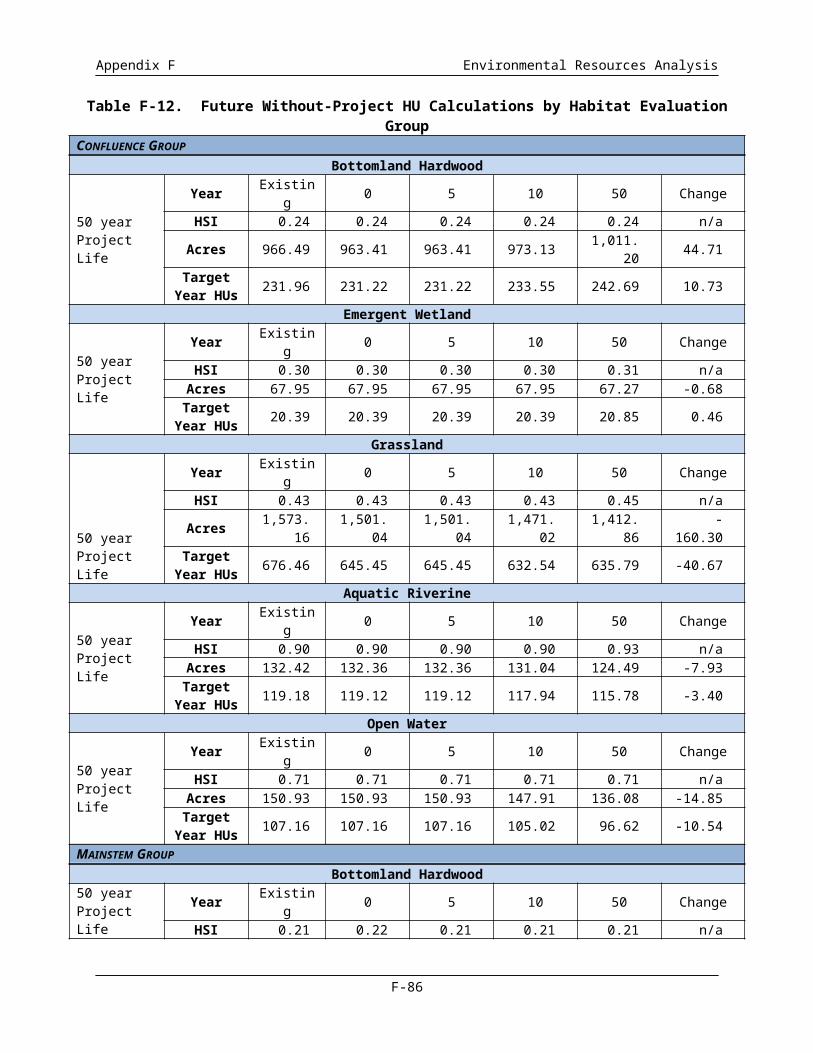
Appendix F Environmental Resources Analysis
deposition patterns around the newly created meander bends. Local bedrock controls have also been integrated into the proposed channel design to serve as anchors for constructed pool depressions and as gradient controls. The proposed channel design includes a revegetation plan that will re-establish native vegetation species at elevations on channel banks determined to be most conducive to their establishment and growth. Riparian vegetation will also contribute to bioengineered bank stabilization designed to limit or prevent bank erosion in high energy reaches with sensitive adjacent infrastructure. Because of the steep, uniform nature of existing channel bank slopes, the transition from in-channel to floodplain habitat is abrupt and limited in habitat quality. The proposed channel realignment design improves on this condition in two ways. First, the proposed in-channel addition, the more gradually sloped banks and high terraces near the top of the channel will improve connectivity through creation of more gradual elevation gradients between the channel and floodplain during high flows. When combined with the proposed floodplain wetland creation associated with other ongoing projects, the channel realignment design will significantly improve floodplain habitat and connectivity. Due to the fact that this feature is required to implement the BVP features, is an engineering challenge and risk to the levee system, is located within the Floodway footprint, and supports all of the planning objectives, this feature is recommended to be part of the MDFP.
Another major ecosystem restoration feature being included in the MDFP is implementation of improvements to the Corinth Wetlands in the southeast corner of the project area. The roughly 36 acres of existing Corinth Wetlands will be enhanced through grading and planting of high quality native emergent aquatic vegetation. In addition, approximately 47 acres of additional high quality wetlands will be created in the area. Restoration/creation of these wetlands will offset adverse impacts to wetlands resulting from the grading and excavation activities associated with the river realignment and will increase the quality of the existing wetland habitat within the study area.
The Natural Lake would be one of the primary borrow sources for the Trinity Parkway. If a 404 Permit is issued for the Trinity Parkway, it would likely be done as a single and complete project, including the borrow source to construct the foundation of the roadway. Thus Natural Lake is not recommended to be part of the MDFP.
Finally, wetlands, including emergent wetlands and constructed stormwater management wetlands associated with recreation features are proposed in the BVP throughout the Floodway by the BVP. The numbers range between 9 and 10 individual wetlands with sizes ranging from 0.8 to 25.7 acres depending on whether the Trinity Parkway is constructed in the Floodway or not. These wetland numbers exclude the Corinth Wetlands, the bottomland hardwood wetlands associated with the river terraces, the marshlands or fringe wetlands located along the edges of the proposed Urban, Natural, and West Dallas Lakes, and emergent wetlands that are currently existing, i.e. are there now and will continue to be there in the future. The Corinth Wetlands and bottomland hardwood wetlands associated with the river terraces are already included in the MDFP. The marshlands would only be considered for inclusion in the MDFP if construction of the associated lake was included, which eliminates them from further consideration. Stormwater wetlands associated with recreation features would only be considered if the applicable recreation element was proposed for consideration in the MDFP no recreation elements are included so the stormwater wetlands are out. Finally, the potential for the remaining proposed emergent wetlands to be adversely impacted by construction activities associated with implementation of the remaining recreation elements of the BVP precludes them from further consideration.
F-87
12345678910111213141516
17181920212223
24252627
282930313233343536373839404142

Appendix F Environmental Resources Analysis
Major recreation features include the Urban and West Dallas Lakes, and multiple superficial recreational facilities such as trails, access roads, parking lots, sports fields, etc. The NED Plan requires suitable borrow material and the West Dallas Lake footprint has been identified as an ideal location for this needed levee material. This is also been identified as the site of borrow material for the 4H:1V side slope improvement proposed to be implemented by the City of Dallas. The NED levee raises take place on approximately 40 percent of the linear length of the levee. To avoid disturbing the same sections of levee multiple times and to reduce cost, it is recommended that the flattening of side slopes be constructed concurrent to the NED plan construction, even though the City of Dallas will be paying for this at 100%. Thus, only excavation of material within the footprint of the West Dallas Lake that is needed to raise the levees and flatten the side slope is considered part of the MDFP. Turning the FRM borrow site into the completed West Dallas Lake, including the proposed wetlands and other associated recreation elements, would be implemented as part of the remaining BVP features to be provided by the city. Similarly, the Urban Lake and the other BVP recreation features will be the responsibility of the City of Dallas and not included in the MDFP, partially due to the fact that the proposed footprint of the Urban Lake may be used as a borrow source for the embankment of the Trinity Parkway if it is built in the Floodway and partially because the kinds or extent of the additional BVP recreational features proposed is beyond the limit of the normal recreation amenities in which USACE routinely cost shares.
1.5.7 Interior Drainage Plan
Implementation of the IDP would reduce predicted 100-year, 24-hour storm event water levels to heights at or below the established City of Dallas water levels, resulting in a significant reduction in the number of structures potentially affected by flooding. This risk reduction would serve to reduce potential stormwater flooding impacts to people and property in the City of Dallas.
The IDP proposes to construct new pump stations and improve the sumps for interior drainage behind the East and West Levee. These project features all contribute to the two most important objectives by maintaining the functioning of the Floodway through improving interior drainage and further reducing flood damages through increasing the level of protection behind the levee system. Furthermore, reducing flood risk is a primary mission of the USACE, and something that the USACE has a significant stake in as part of the functioning of the Dallas Floodway Project. Therefore, it is recommended that most of these project features be included in the MDFP. Due to specific language in the WRDA 2007 and WRRDA 2014 authorizations, all the proposed East and West Levee IDP elements may be included in the study analyses for determination of whether they meet technically sound and environmentally acceptable criteria.
In accordance with the Section 5141 and the Implementation Guidance, the City of Dallas has the ability to advance features of the project prior to execution of the Project Partnership Agreement. With this in mind, the City requested and received approval through the Section 408 process to construct Able, Baker and Pavaho Pump stations. Pavaho is currently operational and Baker and Able are under construction. The City decided that in order to stay within the Section 902 limit they would rather not request credit for the pump stations that they are currently constructing and removed them from consideration as elements of the MDFP. Other elements of the IDP that will not be included in the MDFP include improvements to the Eagle Ford and Trinity-Portland sumps and the Pavaho and Delta sumps.
F-88
1234567891011121314151617
18192021
22232425262728293031
3233343536373839

Appendix F Environmental Resources Analysis
1.5.8 The Modified Dallas Floodway Project
Table F-18 presents the City of Dallas BVP and IDP project features and the subset MDFP. The MDFP includes the NED Plan (277K levee raise with AT&SF Railroad Bridge modifications and EAP improvements), side slope flattening, the IDP Phase I and Phase II, the proposed river relocation, including cut-off walls, the West Dallas Lake borrow area, and a portion of the Corinth Wetlands needed to balance habitat creation/improvements and adverse impacts.
Table F-18. BVP and IDP Features and the Modified Dallas Floodway Project
Category DescriptionProposed BVP and
IDPMDFP
BVP Flood Risk ManagementLevees Raise to 277,000 cfs Flood Height
AT&SFRemoval of Wood Bridge Segment
Removal of Concrete Bridge Segment
Removal of Embankment Segments
Levee Flattening Flattening the Riverside Levee Side Slopes to 4:1
Non-structural Emergency Action Plan Improvements
BVP Study Ecosystem and Recreation
LakesWest Dallas Lake
Urban Lake
Natural Lake
River Realignment and Modification
WetlandsMarshlands
Forested Ponds
Corinth Wetlands
Athletic FacilitiesPotential Flex Fields
Playgrounds
River Access Points
General Features
Parking and Public Roads
Lighting
Vehicular Access
Pedestrian Amenities
Restrooms
Interior Drainage Outfall Extensions
Extend Pump Station Outfalls
Extend Pressure Sewer Outfalls
Able Sump Ponds Recreation and Ecosystem Enhancements Interior Drainage Plan
East Levee
Demolish Old Hampton Pump Station
Construct New Hampton Pump Station
Nobles Branch Sump Improvements
Construct New Baker Pump Station
Construct New Able Pump Station
F-89
12345

Appendix F Environmental Resources Analysis
Table F-18. BVP and IDP Features and the Modified Dallas Floodway Project
Category DescriptionProposed BVP and
IDPMDFP
West Levee
Demolish Old Charlie Pump Station
Construct New Charlie Pumping Station
Rehabilitate Existing Delta Pump Station
Construct New Trinity-Portland Pumping Plant Eagle Ford and Trinity-Portland Sump Improvements
Pavaho and Delta Sump Improvements
As noted above, the Trinity Parkway is currently undergoing NEPA compliance review. The FHWA EIS includes a review of a Trinity Parkway built within the Dallas Floodway Alternative and no Trinity Parkway being built (the No-Action Alternative). Recognizing these two possibilities, the City of Dallas initiated two preliminary designs of the BVP Study Ecosystem and Recreation features – one that would accommodate the Trinity Parkway being built within the Dallas Floodway and a second that realigns various BVP ecosystem and recreation elements if the Trinity Parkway is not constructed. Therefore, descriptions of the impacts of the Modified Dallas Floodway Project and remaining Section 408 BVP/IDP elements both with and without the Trinity Parkway as a Future Condition follow.
Alternative 1: The No-Action Alternative
The No-Action Alternative (or “Future Without-Project Conditions”) is an alternative that assumes the MDFP and remaining BVP/IDP elements are not implemented. An analysis of the No-Action Alternative is included as required by Council on Environmental Quality (CEQ) regulations to establish baseline conditions against which potential impacts can be evaluated.
Alternative 2: Proposed Action (Modified Dallas Floodway Project with remaining BVP/IDP elements)
Proposed Action with Parkway. As described in the Trinity River Corridor Design Guidelines (City of Dallas 2009e), the BVP aimed to “seamlessly integrate” design of the Trinity Parkway and the Trinity Lakes Area by: (1) applying shared aesthetic goals, and (2) mitigating vehicle impacts in coordination with BVP features and functions. Thus, under the Proposed Action with Parkway, the Trinity Parkway is assumed to be constructed within the Dallas Floodway using the preferred alternative identified in the FHWA’ Trinity Parkway Final EIS. The Trinity Parkway proposed action includes excavation of fill material for support and berm building. To maximize construction efficiency, NTTA, the City of Dallas, and the USACE would coordinate to determine if the Trinity Parkway can take fill material from the proposed lake sites. Thus, the excavation needs of the BVP would be decreased, because the Trinity Parkway project would excavate a portion of the lakes for use in the parkway berm, thereby resulting in “double-use” for the lakes areas. All mitigation associated with impacts from construction of the Trinity Parkway would occur outside of the Floodway. Figure F-12 presents an overview of the Proposed Action with Parkway.
F-90
1
23456789
10111213
14151617181920212223242526

Appendix F Environmental Resources Analysis
This Page Intentionally Left Blank.
F-91
1
2
3
4
5
6
7
8
9
10
11
12

Appendix F Environmental Resources Analysis
11x17 Figure
F-12 Overview of Proposed Action with Parkway
F-92
1
2
3

Appendix F Environmental Resources Analysis
Back of Figure F-12
F-93
1

Appendix F Environmental Resources Analysis
Proposed Action without Parkway. While the Trinity Parkway is currently a “reasonably foreseeable” project, there is a possibility that the Trinity Parkway project would not be constructed. Therefore, the USACE and City of Dallas decided to provide NEPA flexibility for this potential outcome by designing a Future Condition without the Trinity Parkway also. Under the Proposed Action without Parkway, the MDFP and remaining BVP/IDP elements would be implemented, but the Trinity Parkway project would not be constructed within the Dallas Floodway. Because the Proposed Action without Parkway assumes that the Trinity Parkway is not in-place in the Dallas Floodway Project, certain BVP Study Ecosystem and Recreation features included in the Proposed Action with Parkway would be different under implementation of the Propose Action without Parkway. There would be no change to the FRM, IDP, and ecosystem restoration elements of the MDFP under either Future Condition design. Figure F-13 presents an overview of the Proposed Action without Parkway future condition.
Summary Comparison of WRDA Alternatives
Table F-19 provides a simple comparison of impacts for Alternatives 1 (Future Without-Project) and the Proposed Action, under both the with and without Trinity Parkway future conditions for the hydrology and hydraulics, water resources and biological resources components within the Study Area.
Table F-19. Summary and Comparison of Impacts for Alternatives 1 and 2 under both the With Parkway or Without Parkway Future Conditions
Resource Area
Alternative 1 (Future Without-
Project Conditions)
Alternative 2 (Proposed Action)Notable Difference Between With and
Without Parkway Future ConditionsWith Trinity Parkway Without Trinity Parkway
Hydrology and Hydraulics
Increased peak flows within the Dallas Floodway.
Overtopping of the levees could occur at several locations during SPF events.
No change to floodplain inundation map extent.
FRM achieved. Water surface elevation
increase in excess of that authorized by the TREIS ROD.
Valley storage loss in excess of that authorized by TREIS ROD for the 100-year flood event or the SPF event.
FRM achieved. Water surface elevation
increase in excess of that authorized by the TREIS ROD.
Valley storage loss in excess of that authorized by TREIS ROD for the 100-year flood event or the SPF event.
Both alternatives exceed TREIS ROD criteria; the Proposed Action with Parkway exceeds criteria less than does the Proposed Action without Parkway.
F-94
1234567891011
12
131415

Appendix F Environmental Resources Analysis
Table F-19. Summary and Comparison of Impacts for Alternatives 1 and 2 under both the With Parkway or Without Parkway Future Conditions
Resource Area
Alternative 1 (Future Without-
Project Conditions)
Alternative 2 (Proposed Action)Notable Difference Between With and
Without Parkway Future ConditionsWith Trinity Parkway Without Trinity Parkway
Water Resources
Increase in urbanization in the Upper Trinity River watershed could increase stormwater pollution.
Short-term negative impacts from construction runoff to jurisdictional wetlands and other waters of the U.S.
Predicted net functional gain from MDFP of 6,115 linear feet for the Trinity River and 28.68 acres for wetlands.
Negative impacts would result in a total loss of 20.81 acres of jurisdictional other waters of the U.S. and 58.31 acres of jurisdictional wetlands. The City of Dallas would be required to purchase credits from an approved mitigation bank at the appropriate ratio.
Short-term negative impacts from construction runoff to jurisdictional wetlands and other waters of the U.S.
Predicted net functional gain from MDFP of 6,115 linear feet for the Trinity River and 6.10 acres for wetlands.
Negative impacts would result in a total loss of 26.72 acres of jurisdictional other waters of the U.S. and 82.41 acres of jurisdictional wetlands. The City of Dallas would be required to purchase credits from an approved mitigation bank at the appropriate ratio.
There would be an overall greater net functional gain via implementation of the MDFP under the Proposed Action with Parkway as compared to the Proposed Action without Parkway. The City of Dallas would need to purchase more credits to offset greater impacts (from their 408 features) to wetlands and other open waters under the Proposed Action without Parkway than the Proposed Action with Parkway.
Biological Resources
Increase in acreage for emergent wetland (1 acre).
Decrease in acreage for bottomland hardwood (-25 acres), grassland (-118 acres), aquatic riverine (-10 acres), and open water (-5 acres).
Increase in habitat units (HUs) for bottomland hardwood (1 HU).
Decrease in HUs for emergent wetland (-3 HUs), grassland (-82 HUs), aquatic riverine (-13 HUs), and open water (-14 HUs).
Increase in acreage for bottomland hardwood (143 acres), aquatic riverine (86 acres), and open water (258 acres).
Decrease in acreage for emergent wetland (-103 acres) and grassland (-691 acres).
Increase in HUs for bottomland hardwood (75 HUs), emergent wetland (21 HUs), aquatic riverine (99 HUs), and open water (197 HUs).
Decrease in HUs for grassland (-213 HUs).
ROI total increase in HUs (179 for the Proposed Action with Parkway; 50 HUs for cumulative)
Increase in acreage for bottomland hardwood (142 acres), aquatic riverine (86 acres), and open water (258 acres).
Decrease in acreage for emergent wetland (-101 acres) and grassland (-687 acres).
Increase in HUs for bottomland hardwood (74 HUs), emergent wetland (22 HUs), aquatic riverine (99 HUs), and open water (197 HUs).
Decrease in HUs for grassland (-235 HUs).
ROI total increase in HUs (158 for the Proposed Action without Parkway; 91 HUs for cumulative)
The Proposed Action with Parkway directly generates 21 more HUs than the Proposed Action without Parkway, primarily in the grassland habitat.
The Proposed Action without Parkway generates more HUs than the Proposed Action with Parkway under cumulative conditions, primarily because the proposed Trinity Parkway is considered with an in-Floodway alignment in the Proposed Action with Parkway but not the Proposed Action without Parkway.
F-95

Appendix F Environmental Resources Analysis
11 x 17 Figure
F-13 Overview of Proposed Action without Parkway
F-96
1
2
3

Appendix F Environmental Resources Analysis
Back of Figure 13
F-97
1
2

Appendix F Environmental Resources Analysis
1.6 ALTERNATIVES EVALUATION OF FISH AND WILDLIFE IMPACTS
This section describes potential impacts to fish and wildlife habitats over the next 50 years from implementation of Proposed Action with- or without Parkway. The same Study Area habitat types (bottomland hardwood, emergent wetland, grassland, aquatic riverine, and open-water) and evaluation groups (Confluence, IDS, and Mainstem) are used for the evaluation. The impacts to fish and wildlife habitats from the implementation of the Proposed Action either with or without Parkway, including the implementation of the BVP features, FRM elements, and IDP improvements, are described below. The BVP features are still conceptual in design; as a result, the impacts of these features cannot be determined to the same level of precision as those associated with Existing Conditions. Thus, impacts from Dallas Floodway Project implementation are estimated to the nearest whole acre.
1.6.1 Alternative 2 - Proposed Action with Parkway - Changes to Habitat Acreages
Figure F-14 displays the projected habitat types that would result with implementation of Alternative 2 – Proposed Action with Parkway.
Confluence Group
The Confluence Group includes the Elm Fork and West Fork of the Trinity River and the associated emergent wetland and upland habitat in the area. The Proposed Action with Parkway activities in the Confluence consist of the FRM elements and the IDP Trinity-Portland Pumping Plant and Eagle Ford and Trinity-Portland sump improvements. Table F-20 presents the predicted acreages for the habitat types in the Confluence Group over the next 50 years from the implementation of the Proposed Action with Parkway.
Table F-20. Estimated Changes in Habitat Acreages in the Confluence Group over the Next 50 Years for Existing, Future Without, and Proposed Action with Parkway
Habitat Type Existing Conditions Future Without-Project Conditions
Year (acres)0 5 10 50
Bottomland Hardwood 967 1,011 966 966 976 1,016Emergent Wetland 68 68 68 68 68 67Grassland 1,573 1,413 1,574 1,574 1,543 1,482Aquatic Riverine 132 124 133 133 132 125Open Water 151 136 151 151 148 136
Habitat Subtotal 2,891 2,751 2,892 2,892 2,867 2,826Urban Area 927 1,066 926 926 951 992
Total 3,818 3,818 3,818 3,818 3,818 3,818
Bottomland Hardwood. The bottomland hardwood acreage is expected to remain at 966 acres from year 0 to 5. Bottomland hardwood areas within the confluence are expected to decrease over time due to development. At years 10 and 50, one percent of the bottomland hardwood habitat is expected to be developed. However, at years 10 and 50, the bottomland hardwood acreage is expected to increase from the conversion of aquatic riverine to grassland, and open water habitat to bottomland hardwood from drier conditions.
F-98
123456789
1011
12
131415161718
192021222324

Appendix F Environmental Resources Analysis
Emergent Wetland. From year 0 to 10, the emergent wetland acreage is expected to remain at 68 acres. At year 50, one percent of the emergent wetlands are expected to convert to grassland due to siltation and drier conditions from climate change.
Grassland. From year 0 to 5, the grassland acreage is expected to remain at 1,574 acres. At year 10, one percent of grassland habitat is expected to be converted to bottomland hardwood and one percent is expected to be developed. At year 50, two percent of grassland habitat is expected to be converted to bottomland hardwood and two percent is expected to be developed.
Aquatic Riverine. The aquatic riverine acreage is expected to remain at 133 acres from year 0 to 5. At year 10, one percent of the aquatic habitat is expected to convert to bottomland hardwoods due to less water reaching the Confluence. This could be from drier conditions and/or residents and businesses retaining more water on their properties. By year 50, five percent of the aquatic riverine habitat is expected to be converted to bottomland hardwoods, primarily due to warmer and drier conditions from climate change.
Open Water. The open-water acreage would remain at 151 acres from year 0 to 5. At year 10, two percent of open-water is expected to be converted to bottomland hardwood. The habitat conversion is expected to occur from the filling-in of open water from siltation and drying out from less rainfall. At year 50, conditions are expected to be drier from climate change; therefore, eight percent of open-water is expected to convert to bottomland hardwoods.
Urban. Urban habitat would increase from development projects that occur in the IDS Group over the next 50 years. At years 10 and 50, additional grassland habitat and bottomland hardwood habitat is expected to be developed.
Mainstem Group
The habitat in the Mainstem Group has existed in its current state for the last 50 years. Under the Proposed Action with Parkway, most of the habitat in the Mainstem Group would be temporarily impacted during the implementation of the BVP Study features. After the 10-year construction period for the BVP Study features is complete (2015-2025), most of the habitat would be restored to a higher habitat value than its current state. Three large lakes, re-alignment of the Trinity River, fringe riparian habitat, native grassland meadows, additional bottomland hardwoods, and additional higher quality wetlands would be created with the implementation of the BVP (refer to Figure 13). The Proposed Action with Parkway FRM elements would improve the levees and have minimal impacts on habitat. The Proposed Action with Parkway IDP improvements would add a small amount of aquatic riverine acreage to the Mainstem Group from the creation of outfalls at Charlie and Hampton pump stations.
Table F-21 presents the predicted acreages for the habitat types in the Mainstem Group over the next 50 years with the implementation of the Proposed Action with Parkway.
F-99
123
4567
8910111213
1415161718
192021
22
23242526272829303132
3334

Appendix F Environmental Resources Analysis
Figure
F-14 Habitat Types Under Alternative 2 - Proposed Action with Parkway
F-100
1
2
3

Appendix F Environmental Resources Analysis
Back
F-101
1
2

Appendix F Environmental Resources Analysis
Table F-21. Estimated Changes in Habitat Acreages for the Mainstem Group over the Next 50 Years for Existing, Future Without, and Proposed Action with Parkway
Habitat Type Existing Conditions
Future Without-Project
Conditions
Year
0 1 5 10 25 50
Bottomland Hardwood 95 94 195 195 195 198 203 215Emergent Wetland
Existing 263 258 32 32 32 32 32 32Proposed - - 152 152 152 152 152 150Wetland Subtotal 263 258 184 184 184 184 184 182
GrasslandExisting Maintenance Levels 1,752 1,672 192 192 192 192 192 194
Meadow - - 887 887 887 887 887 887Urban Forest - - 5 5 5 5 5 5Turf - - 158 158 158 158 158 158Grassland Subtotal 1,752 1,672 1,242 1,242 1,242 1,242 1,242 1,244
Aquatic Riverine* 124 108 250 250 250 247 242 230Open Water
Existing - Crow Lake 6 6 6 6 6 6 6 6Natural Lake - - 50 50 50 50 50 50Urban and West Dallas Lakes - - 207 207 207 207 207 207
Open Water Subtotal 6 6 263 263 263 263 263 263Habitat Subtotal 2,240 2,138 2,134 2,134 2,134 2,134 2,134 2,134
Urban Area 36 138 142 142 142 142 142 142Total 2,276 2,276 2,276 2,276 2,276 2,276 2,276 2,276
Bottomland Hardwood. Under the Proposed Action with Parkway, most of the existing bottomland hardwoods would be removed during the re-alignment of the Trinity River under the BVP Study features. During the implementation of the BVP Study features, over 100 acres of bottomland hardwood would be planted in the Mainstem Group, primarily along the southeastern section of the new Trinity River channel.
The acreage of bottomland hardwoods is not expected to increase because the hardwoods would be planted in an area adjacent to the levee and they would not be allowed to expand next to the levee. Therefore, no change to acreage is expected over the next 50 years. At years 10, 25, and 50, an increase of bottomland habitat is expected from the conversion of aquatic riverine to bottomland hardwood.
Emergent Wetland. The Mainstem Group wetlands under the Proposed Action with Parkway would comprise approximately 184 acres - 32 acres of existing wetlands and 152 acres of wetlands created from the implementation of the BVP Study features. The created wetlands would include Corinth and fringe marsh wetlands along the edge of the lakes.
F-102
1
2
34567
891011
12131415

Appendix F Environmental Resources Analysis
With the proposed maintenance of the BVP in the Mainstem Group, the acreage of emergent wetlands in the Mainstem Group is expected to stay the same over the next 10 to 25 years. At year 50, one percent of the emergent wetlands are expected to convert to grassland because of siltation and warmer and drier conditions from climate change.
Grassland. With the implementation of the BVP Study features, the majority of the existing grasslands would be temporarily disturbed and would be replanted and realigned after the completion of the BVP Study features. The grasslands would consist of low quality mowed turf, native meadows, and urban forests.
Due to the proposed maintenance of the grasslands in the Mainstem Group, no change to BVP grassland acreage is expected over the next 50 years. At year 50, the acreage is expected to increase slightly, due to existing emergent wetland converting to grassland.
Aquatic Riverine. The aquatic riverine habitat value and acreage in the Mainstem Group would change significantly under the Proposed Action with Parkway. Under the BVP Study features, the Trinity River is proposed to be re-routed to increase sinuosity and increase habitat value. The Mainstem Group aquatic riverine would include fringe riparian habitat.
The aquatic riverine acreage is expected to remain at 250 acres from year 0 to 5. At year 10, one percent of the aquatic habitat is expected to convert to bottomland hardwoods as a result of less water reaching the Mainstem Group. This could be from warmer and drier conditions and/or residents and businesses retaining more water on their properties. At year 25, two percent of aquatic riverine is expected to be converted to bottomland hardwoods. By year 50, five percent of the aquatic riverine habitat is expected to be converted to bottomland hardwoods, primarily due to warmer and drier conditions from climate change.
Open Water. Under the Proposed Action with Parkway, the Mainstem Group would comprise 263 acres of open water, including the existing Crow Lake and three BVP Study lakes, Urban, West Dallas, and Natural. The lakes would be maintained; therefore, no change to open water acreage is expected over the next 50 years.
Interior Drainage Systems Group
The IDS Group is primarily an urban area with pockets of habitat surrounding the existing sumps, pumps, and drainage channels. The Proposed Action with Parkway activities in the IDS consist of the Charlie, Delta, and Hampton Pumping Plant improvements, and the Nobles Branch and East Levee sump improvements. Table F-22 presents the predicted acreages for the habitat types in the IDS Group over the next 50 years with the implementation of the Proposed Action with Parkway.
Bottomland Hardwood. At year 5, one percent of bottomland hardwood habitat is expected to be developed. At year 10, three percent of bottomland hardwood habitat is expected to be developed. At year 50, seven percent of bottomland hardwood habitat is expected to be developed.
F-103
1234
5678
91011
12131415
16171819202122
23242526
27
2829303132
333435

Appendix F Environmental Resources Analysis
Table F-22. Estimated Changes in Habitat Acreages in the Interior Drainage Systems Group over the Next 50 Years for Existing, Future Without, and Proposed Action with Parkway
Habitat Type Existing Conditions Future Without-Project Conditions
Year (acres)0 5 10 50
Bottomland Hardwood 352 326 350 347 339 326Emergent Wetland 88 89 67 67 67 67
GrasslandExisting Maintenance Levels 958 841 945 936 908 844
Urban Forest 0 0 22 22 22 22Grassland Subtotal 958 841 967 958 930 866
Aquatic Riverine 165 155 162 162 160 152Open Water 49 44 72 72 71 65
Habitat Subtotal 1,612 1,455 1,618 1,606 1,567 1,476Urban Area 9,437 9,594 9,431 9,443 9,482 9,573
Total 11,049 11,04911,04
9 11,049 11,049 11,049
Bottomland Hardwood. At year 5, one percent of bottomland hardwood habitat is expected to be developed. At year 10, three percent of bottomland hardwood habitat is expected to be developed. At year 50, seven percent of bottomland hardwood habitat is expected to be developed.
Emergent Wetland. The emergent wetlands are part of the sump pump areas and would remain. No changes to acreage is expected over the next 50 years. The primary purpose of the emergent wetland areas are flood control, not to provide habitat.
Grassland. At year 5, one percent of grassland habitat is expected to be either converted or developed. At year 10, that percentage is roughly four percent. At year 50, roughly ten percent of grassland habitat is expected to be either converted or developed.
Aquatic Riverine. The aquatic riverine acreage is expected to remain at 162 from year 0 to 5. At year 10, one percent of the aquatic habitat is expected to convert to bottomland hardwoods due to less water from urban area reaching the IDS. This could be from warmer and drier conditions and/or residents and businesses retaining more water on their properties so less water reaches the storm drains. By year 50, six percent of the aquatic riverine habitat is expected to convert to bottomland hardwoods, primarily due to warmer and drier conditions from climate change.
Open Water. The open-water acreage would remain the same from year 0 to 5. At year 10, two percent of open-water is expected to convert to bottomland hardwood (one percent) and urban (one percent). The habitat conversion is expected to occur from the filling-in of open-water from siltation and drying out from less rainfall and more evaporation from warmer temperatures. It is anticipated that half the area would convert to bottomland hardwood and the other half would become disturbed (urban). At year 50, conditions are expected to be warmer and drier from climate change; therefore, more habitat would convert to bottomland hardwoods and disturbed (urban) areas.
HSI Values for the Proposed Action with Parkway
HSI values for the Proposed Action with Parkway were based in the species models used for the baseline assessment. In April 2013, the USFWS hosted the USACE to coordinate and assist in prediction of the future conditions with the action alternative completed. The Trinity River Corridor Design Guidelines
F-104
123
456
789
101112131415
16171819202122
232425

Appendix F Environmental Resources Analysis
(City of Dallas 2009e) was used to inform the models in terms of future plant assemblage and habitat anticipated within the Floodway.
Confluence
The HSI and HU values progressions for the Confluence are presented in Table F-23.
Table F-23. Estimated HSIs, Acreages, and HUs for Habitat Types in the Confluence Group over the Next 50 Years for Existing, Future Without, and Proposed Action with Parkway
Metric Existing Conditions Future Without-Project Conditions
Year0 5 10 50
Bottomland HardwoodHSI 0.24 0.24 0.24 0.24 0.24 0.24Acres 966.49 1,011 966 966 976 1,016HUs 231.96 242.69 231.84 231.84 234.24 243.84
Emergent WetlandHSI 0.30 0.31 0.30 0.30 0.30 0.31Acres 67.95 67 68 68 68 67HUs 20.39 20.85 20.40 20.40 20.40 20.77
GrasslandHSI 0.43 0.45 0.43 0.43 0.43 0.45Acres 1,573.16 1,413 1,574 1,574 1,543 1,482HUs 676.46 635.79 676.82 676.82 663.49 666.90
Aquatic RiverineHSI 0.9 0.93 0.90 0.90 0.90 0.93Acres 132.42 124 133 133 132 125HUs 119.18 115.78 119.70 119.70 118.80 116.25
Open WaterHSI 0.71 0.71 0.71 0.71 0.71 0.71Acres 150.93 136 151 151 148 136HUs 107.16 96.62 107.21 107.21 105.08 96.56
Note: Existing conditions acreages are to the 100th of an acre to be consistent with the existing conditions in Chapter 3. The Future Without-Project and Proposed Action acreages are presented in whole numbers.
Mainstem Group
Table F-24 presents the Proposed Action with Parkway HSIs, acres, and HUs for the Mainstem Group for bottomland hardwood, emergent wetland, grassland, aquatic riverine, and open-water habitat over the next 50 years. With the implementation of the BVP features, most of the habitat in the Mainstem Group would be temporarily disturbed. Following the implementation of the BVP features (years 0, 1, and 5), the bottomland hardwood, emergent wetland, and urban forest HSIs would be low because the habitats would have just been created and would take time to become established. The bottomland hardwood HSIs are expected to increase over time as the trees mature, and the emergent wetland HSIs are expected to increase over time as the wetlands become more established.
The Mainstem Group grasslands would consist of native meadow, turf, and urban forest. The native meadow is expected to have a higher HSI than the existing non-native dominated grassland and is expected to increase in value over the next 50 years from increased native species diversity. The turf HSI is not expected to change over time because mowed grass is expected to remain at the same low habitat value over the next 50 years. The urban forest is expected to take 10 to 25 years to mature; therefore, HSIs are expected to increase from years 5 to 25. Urban forest is considered a subset of grassland
F-105
12
3
4
5
678910111213
141516171819

Appendix F Environmental Resources Analysis
because the majority of the proposed trees would be non-native ornamental trees and do not provide the same habitat value as a native forest.
Aquatic riverine and open water habitat HSIs are not expected to increase much over time because, according to the Texas Aquatic Index of Biological Integrity that was performed as part of the study, they already have a relatively high quality, diverse fisheries population, which would be expected to remain once the BVP features are completed. At year 50, the aquatic riverine HSI is expected to increase due to increased regulations and technology for improvements to water quality and the increased in-stream structure and shade resulting from implementation of the river realignment. The open-water HSI was determined by referring to the 2010 fisheries sampling in Crow Lake, Bart Simpson Lake, and Cell D of the Dallas Floodway Extension (USACE 2010c).
Table F-24. Estimated HSIs, Acreages, and Habitat Units for Habitat Types in the Mainstem Group over the Next 50 Years for Existing, Future Without, and Proposed Action with Parkway
Metric Existing Conditions
FutureWithout-Project
Conditions
Year
0 1 5 10 25 50
Bottomland HardwoodHSI 0.21 0.21 0.09 0.09 0.09 0.13 0.21 0.43Acres 94.64 94 195 195 195 198 203 215HUs 19.87 19.74 17.55 17.55 17.55 25.74 42.63 92.45
Emergent WetlandExisting
HSI 0.22 0.22 0.22 0.22 0.22 0.22 0.22 0.22Acres 262.91 263 32 32 32 32 32 32HUs 57.84 57.86 7.04 7.04 7.04 7.04 7.04 7.04
ProposedHSI - 0.22 0.13 0.13 0.34 0.42 0.47 0.52Acres - -5 152 152 152 152 152 150HUs - -1.10 19.76 19.76 51.68 63.84 71.44 78.00
Wetland HU Subtotal 57.84 56.76 26.80 26.80 58.72 70.88 78.48 85.04
GrasslandExisting Maintenance Levels
HSI 0.62 0.64 0.40 0.40 0.40 0.40 0.40 0.40
Acres1,752.1
5 1,672 192 192 192 192 192 194
HUs1,086.3
3 1,070.08 76.80 76.80 76.80 76.80 76.80 77.60
MeadowHSI - - 0.50 0.60 0.70 0.65 0.70 0.85Acres - - 887 887 887 887 887 887HUs - - 443.50 532.20 620.90 576.55 620.90 753.95
Landscaping: TurfHSI - - 0.00 0.00 0.40 0.40 0.40 0.40Acres - - 158 158 158 158 158 158HUs - - 0.00 0.00 63.20 63.20 63.20 63.20
Landscaping: Urban ForestHSI - - 0.50 0.50 0.40 0.40 0.40 0.40Acres - - 5 5 5 5 5 5HUs - - 2.50 2.50 2.00 2.00 2.00 2.00
F-106
12
345678910

Appendix F Environmental Resources Analysis
Table F-24. Estimated HSIs, Acreages, and Habitat Units for Habitat Types in the Mainstem Group over the Next 50 Years for Existing, Future Without, and Proposed Action with Parkway
Metric Existing Conditions
FutureWithout-Project
Conditions
Year0 1 5 10 25 50
Grassland HU Subtotal
1,086.33 1,070.08 522.80 611.50 762.90 718.55 762.90 896.75
Aquatic RiverineHSI 0.83 0.86 0.83 0.75 0.83 0.85 0.87 0.90Acres 123.73 108 250 250 250 247 242 230HUs 102.70 92.88 207.50 187.50 207.50 209.95 210.54 207.00
Open WaterCrow Lake
HUs 4.55 4.55 4.55 4.55 4.55 4.55 4.55 4.55Urban Lake & West Dallas Lake
HSI - - 0.00 0.00 0.43 0.77 0.77 0.77Acres - - 207 207 207 207 207 207HUs - - 0.00 0.00 89.01 159.39 159.39 159.39
Natural LakeHSI - - 0.00 0.00 0.60 0.77 0.77 0.77Acres - - 50 50 50 50 50 50HUs - - 0.00 0.00 30.00 38.50 38.50 38.50
Open Water HU Subtotal 4.55 4.55 4.55 4.55 123.56 202.44 202.44 202.44
Interior Drainage Systems
Table F-25 presents the Proposed Action with Parkway HSIs, acres, and HUs for the IDS for bottomland hardwood, emergent wetland, grassland, aquatic riverine, and open-water habitat over the next 50 years.
The majority of the bottomland hardwoods occur along the drainage channels. The quality (HSI) of the bottomland hardwoods are expected to remain consistent over time. Bottomland hardwood areas within the IDS are expected to decrease over time due to development. Bottomland hardwood habitats do not have any special protection from development.
The emergent wetlands are part of the sump pump areas and will remain. Little change to emergent wetland quality (HSI) or acreage is expected over the next 50 years. The primary purpose of the emergent wetland areas are flood control, not to provide habitat.
The majority of the grasslands occur along the drainage channels. The quality (HSI) of the grassland habitat is expected to remain much the same over time due to the routine maintenance that is expected to continue. Grassland areas are expected to decrease over time because of development. Grassland habitats do not have any special protection from development.
The aquatic riverine HSI was determined using the Trinity River IBI (USFWS 2004). Reach 1, the lower reach of the Mainstem Group, had the lowest HSI of the four reaches and was determined to be the most similar of the four reaches. The IDS Group is smaller than the Trinity River, has less species diversity, and is not connected to the Trinity River for species dispersal; therefore, it is expected to have a lower HSI than the rest of the River. The HSI is expected to remain at 0.7 from year 0 to 5 because of siltation, erosion, and other temporary impacts from construction. At year 10, the HSI is expected to be back at 0.75 (pre-construction conditions). By year 50, the HSI is expected to increase to 0.80 due to increased regulations and technology for improvements to water quality.
F-107
1
23
4567
8910
11121314
1516171819202122

Appendix F Environmental Resources Analysis
The open-water HSI was determined from 2010 fisheries sampling (USACE 2010c). Because the IDS Group is smaller than the Trinity River, has less species diversity, and is not connected to the Trinity River for species dispersal, it is expected to have a lower HSI than the Mainstem or Confluence groups of the Trinity River. Therefore, the average open-water HSI score was adjusted to 0.65. The water quality in the open-water is not expected to change in the next 50 years; therefore, the HSI would remain the same for the next 50 years.
Table F-25. Estimated Habitat Suitability Indices, Acreages, and Habitat Units for Habitat Types in the Interior Drainage Systems Group over the Next 50 Years for Existing, Future Without, and
Proposed Action with Parkway
Metric Existing Conditions Future Without-Project Conditions
Year0 5 10 50
Bottomland HardwoodHSI 0.39 0.39 0.39 0.39 0.39 0.39Acres 351.5 326 350 347 339 326HUs 137.09 127.14 136.50 135.33 132.21 127.14
Emergent WetlandHSI 0.22 0.19 0.23 0.22 0.22 0.19Acres 87.72 89 67 67 67 67HUs 19.3 16.91 15.41 14.74 14.74 12.73
GrasslandExisting Maintenance Levels
HSI 0.57 0.62 0.57 0.57 0.57 0.62Acres 958.26 841 945 936 908 844HUs 546.21 521.42 538.65 533.52 517.56 523.28
Landscaping: Urban ForestHSI - - 0.50 0.40 0.40 0.40Acres - - 22 22 22 22HUs - - 11.00 8.80 8.80 8.80
Grassland HU Subtotal 546.21 521.42 549.65 542.32 526.36 532.08Aquatic Riverine
HSI 0.75 0.80 0.70 0.70 0.75 0.80Acres 165.18 155 162 162 160 152HUs 123.89 124.00 113.40 113.40 120.00 121.60
Open WaterHSI 0.65 0.65 0.65 0.65 0.65 0.65Acres 49.3 44 72 72 71 65HUs 32.05 28.60 46.80 46.80 46.15 42.25
Alternative 2 - Proposed Action with Parkway – HU Summary
As presented in Table F-26, overall HUs would increase under the Proposed Action with Parkway over the next 50 years. The greatest increase would be to open water from the creation of the BVP lakes. Bottomland hardwood and emergent wetland habitat would also increase with the highest quality habitat along the river and at the southeastern end of the project area. Aquatic Riverine habitat would increase from the realignment of the river. The greatest decrease of HUs would be to grassland habitat.
F-108
123456
7891011

Appendix F Environmental Resources Analysis
Table F-26. HUs per Habitat Type Within the Study Area for Existing, Future Without, and Proposed Action with Parkway
Habitat Types
Habitat Units
Existing Conditions
Future Without-Project Conditions(Year 50)
The Proposed Action with
Parkway(Year 50)
Change
Bottomland Hardwood 388.92 389.59 463.43 73.84Emergent Wetland 97.53 94.48 118.54 24.06Grassland 2,309.00 2,227.24 2,095.73 -131.51Aquatic Riverine 345.77 332.84 444.85 112.01Open Water 143.76 129.90 341.25 211.35
Total 3,284.98 3,174.06 3,463.80 289.74
Table F-27 presents Existing Conditions, the Future Without-Project Conditions (baseline), and the Proposed Action with Parkway (Year 50) HUs for the five habitat types in the Confluence, IDS, and Mainstem groups.
Table F-27. Estimated HU Values for Habitats within the Study Area for Future Without and Proposed Action with Parkway (Year 50)
Evaluation Areas
Habitat Units
Future Without-Project Conditions
Alternative 2 - Proposed Action
with ParkwayChange
Bottomland HardwoodConfluence 242.69 243.84 1.15IDS 127.12 127.14 0.02Mainstem 19.78 92.45 72.67
Total 389.59 463.43 73.84Emergent Wetland
Confluence 20.85 20.77 -0.08IDS 16.91 12.73 -4.18Mainstem 56.72 85.04 28.32
Total 94.48 118.54 24.06Grassland
Confluence 635.79 666.90 31.11IDS 521.22 532.08 10.86Mainstem 1,070.23 896.75 -173.48
Total 2,227.24 2,095.73 -131.51Aquatic Riverine
Confluence 115.78 116.25 0.47IDS 124.09 121.60 -2.49Mainstem 92.97 207.00 114.03
Total 332.84 444.85 112.01Open Water
Confluence 96.62 96.56 -0.06IDS 28.73 42.25 13.52Mainstem 4.55 202.44 197.89
Total 129.90 341.25 211.35
F-109
1
234

Appendix F Environmental Resources Analysis
Bottomland Hardwood. HUs in the Confluence, Mainstem, and IDS groups would increase in 50 years under the Proposed Action with Parkway due to bottomland hardwoods being planted in as part of the BVP features, and a small component of grassland, aquatic riverine, and open-water habitat conversion over time.
Emergent Wetland. HUs in the Confluence and IDS groups would decrease slightly over time due to development and conversion to other habitat types. HUs in the Mainstem Group would increase in 50 years under the Proposed Action with Parkway due to the creation and maintenance of higher quality emergent wetlands.
Grassland. HUs in the Confluence and IDS groups would increase modestly over time as the result of slight increases in habitat quality. The Mainstem Group would decrease in 50 years under the Proposed Action with Parkway due to development.
Aquatic Riverine. HUs in the Mainstem Group would increase in 50 years under the Proposed Action with Parkway due to the realignment of the Trinity River using Natural Stream Channel design principles and increased regulations and technological advances to increase water quality. Remain essentially the same in the IDS and in the Confluence Group would decrease slightly under the Proposed Action with Parkway due to aquatic riverine habitat being lost to development of new pumping stations and sumps.
Open Water. HUs in the Mainstem and IDS groups would increase in 50 years due to the creation of West Dallas, Urban, and Natural Lakes and new sump ponds. Open water HUs in the Confluence Group would decrease slightly in 50 years under the Proposed Action with Parkway due to open-water habitat converting to bottomland hardwoods in the Confluence Group from warmer and drier conditions.
Alternative 2 - Proposed Action with Parkway - Threatened and Endangered Species and Birds of Conservation Concern
The potential for threatened or endangered species, or birds of conservation concern, within the Study Area under the Proposed Action with Parkway is anticipated to be the same as that under Alternative 1, or the Future Without-Project Conditions.
Habitat values should be higher than Existing Conditions and the Future Without-Project Conditions. However, similar to Alternative 1, federally listed species are not likely to breed or establish permanent residences in the Study Area under the Proposed Action with Parkway.
Alternative 2 - Proposed Action with Parkway - Summary
Under the Proposed Action with Parkway, overall HUs would increase. The greatest increase would be to open water from the creation of the BVP lakes. Bottomland hardwood habitat would also increase with the highest quality habitat at the southeastern end of the project area. Aquatic riverine habitat would increase from the realignment of the river. The greatest decrease of HUs would be to grassland habitat.
1.6.2 Alternative 2 – Proposed Action Without Parkway - Changes To Habitat Acreages
Figure F-15 displays the BVP features, FRM elements, and IDP improvements for the Proposed Action without Parkway – BVP/IDP Without Parkway. Table F-28 presents the predicted acreages for the habitat types in the Mainstem Group over the next 50 years with the implementation of the Proposed Action without Parkway.
F-110
1234
5678
91011
1213141516
17181920
212223
242526
27282930
31323334
35

Appendix F Environmental Resources Analysis
Table F-28. Estimated Changes in Habitat Acreages for the Mainstem Group over the Next 50 Years for Existing, Future Without, and Proposed Action without Parkway
Habitat TypeExisting
Conditions
FutureWithout-Project
Conditions(Year 50)
Year
0 1 5 10 25 50
Bottomland Hardwood 95 94 194 194 194 197 202 214Emergent Wetland
Existing 263 258 32 32 32 32 32 32Proposed - - 154 154 154 154 154 152
Wetland Subtotal 263 258 186 186 186 186 186 184Grassland
Existing Maintenance Levels 1,752 1,672 191 191 191 191 191 193
Landscaping: Meadow - - 844 844 844 844 844 844Landscaping: Urban Forest - - 15 15 15 15 15 15
Landscaping: Turf - - 186 186 186 186 186 186Grassland Subtotal 1,752 1,672 1,236 1,236 1,236 1,236 1,236 1,238Aquatic Riverine* 124 108 250 250 250 247 242 230
Open WaterExisting - Crow Lake 6 6 6 6 6 6 6 6Natural Lake - - 50 50 50 50 50 50Urban and West Dallas Lake - - 207 207 207 207 207 207
Open Water Subtotal 6 6 263 263 263 263 263 263Habitat Subtotal 2,240 2,138 2,129 2,129 2,129 2,129 2,129 2,129Urban Area 36 138 147 147 147 147 147 147
Total 2,276 2,276 2,276 2,276 2,276 2,276 2,276 2,276
Bottomland Hardwood. Under the Proposed Action without Parkway, most of the existing bottomland hardwoods would be removed during the realignment and modification of the Trinity River under the BVP Study features. During the implementation of the BVP Study features, 100 acres of bottomland hardwood would be planted in the Mainstem Group, primarily along the southeastern section of the new Trinity River channel.
It is anticipated that there would be a small increase in the acreage of bottomland hardwoods over time as areas; however, any hardwoods planted in areas adjacent to the levee would not be allowed to expand closer to the levee. At years 10 and 50, an increase of bottomland habitat is expected from the conversion of aquatic riverine to bottomland hardwood.
F-111
12345
6789

Appendix F Environmental Resources Analysis
11x17Figure
F-15 Habitat Types Under Alternative 2 - Proposed Action without Parkway
F-112
1
23
4

Appendix F Environmental Resources Analysis
Back of Figure 15
F-113
12

Appendix F Environmental Resources Analysis
Emergent Wetland. The Mainstem Group wetlands under the Proposed Action without Parkway would consist of approximately 186 acres of wetlands consisting of approximately 32 acres of existing wetlands and approximately 154 of wetlands created from the implementation of the BVP Study features. The created wetlands would include Corinth and fringe marsh wetlands along the edge of the lakes.
Due to the proposed maintenance of the BVP Study features in the Mainstem Group, the acreage of emergent wetlands in the Mainstem Group is expected to stay the same over the next 10 years. At year 50, one percent of the emergent wetlands are expected to convert to grassland due to siltation and warmer and drier conditions from climate change.
Grassland. With the implementation of the BVP Study features, the majority of the existing grasslands would be temporarily disturbed and would be replanted and realigned after the completion of the BVP Study features. BVP grasslands would consist of low quality grasses on levees that are routinely mowed, landscaped turf, native meadows, and urban forests.
Due to the proposed maintenance of the BVP Study features in the Mainstem Group, no changes to grassland acreage is expected over the next 50 years. At year 50, the acreage is expected to increase by one percent, due to the emergent wetland converting to grassland.
Aquatic Riverine. The aquatic riverine habitat value and acreage in the Mainstem Group would change significantly under the Proposed Action without Parkway. Under the BVP Study features, the Trinity River is proposed to be realigned and modified to increase sinuosity and increase habitat value. The Mainstem Group aquatic riverine would include fringe riparian habitat.
The aquatic riverine acreage is expected to remain at 250 acres from year 0 to 5. At year 10, one percent of the aquatic habitat is expected to convert to bottomland hardwoods due to less water reaching the Mainstem Group. This could be from warmer and drier conditions and/or residents and businesses retaining more water on their properties. By year 50, roughly eight percent of the aquatic riverine habitat is expected to be converted to bottomland hardwoods, primarily due to warmer and drier conditions from climate change.
Open Water. The Mainstem Group under the Proposed Action without Parkway would encompass 263 acres of open water consisting of the existing Crow Lake and Urban, West Dallas, and Natural lakes that would be created under the BVP features. The lakes would be maintained; therefore, no change to open water acreage is expected over the next 50 years. The lakes would be maintained; therefore, no change to open water acreage is expected over the next 50 years.
Interior Drainage Systems Group
For the IDS Group, the Proposed Action without Parkway would result in the same changes to habitat acreages as described above for the Proposed Action with Parkway.
Alternative 2 - Proposed Action without Parkway - Habitat Suitability Index Values
HSIs for the Proposed Action without Parkway were based in the species models used for the baseline assessment. In April 2013, the USFWS met with the USACE to coordinate and assist in prediction of the future conditions with the action alternative completed. The Trinity River Corridor Design Guidelines (City of Dallas 2009e) was used to inform the models in terms of future plant assemblage and habitat anticipated within the Floodway.
F-114
1234
5678
9101112
131415
16171819
202122232425
2627282930
31
3233
3435363738

Appendix F Environmental Resources Analysis
Confluence Group
The HSI and HU values for the Confluence Group are anticipated to be the same as those under the Proposed Action with Parkway.
Mainstem Group
Table F-29 provides HSIs, acres, and HUs under the Proposed Action without Parkway for the Mainstem Group for bottomland hardwood, emergent wetland, grassland, aquatic riverine, and open-water habitat over the next 50 years. With the implementation of the BVP Study features, most of the habitat in the Mainstem Group would be temporarily disturbed. Following the implementation of the BVP features (Years 0, 1, and 5), the bottomland hardwood, emergent wetland, and urban forest HSIs would be low because the habitats would have just been created and require time to become established. The bottomland hardwood HSIs are expected to increase over time as the trees mature, and the emergent wetland HSIs are expected to increase over time as the wetlands become more established.
Table F-29. Estimated HSIs, Acreages, and Habitat Units for Habitat Types in the Mainstem Group over the Next 50 Years for Existing, Future Without, and Proposed Action Without Parkway
Metric Existing Conditions
FutureWithout-Project
Conditions(Year 50)
Year
0 1 5 10 25 50
Bottomland HardwoodHSI 0.21 0.21 0.09 0.09 0.09 0.13 0.21 0.43Acres 94.64 94 194 194 194 197 202 214HUs 19.87 19.74 17.46 17.46 17.46 25.61 42.42 92.02
Emergent WetlandExisting
HSI 0.22 0.22 0.22 0.22 0.22 0.22 0.22 0.22Acres 262.91 263 32 32 32 32 32 32HUs 57.84 57.86 7.04 7.04 7.04 7.04 7.04 7.04
ProposedHSI - 0.22 0.13 0.13 0.34 0.42 0.47 0.52Acres - -5.00 154 154 154 154 154 152HUs - -1.10 20.02 20.02 52.36 64.68 72.38 79.04
Wetland HU Subtotal 57.84 56.76 27.06 27.06 59.40 71.72 79.42 86.08
GrasslandExisting Maintenance Levels
HSI 0.62 0.64 0.40 0.40 0.40 0.40 0.40 0.40Acres 1,752.15 1,672 191 191 191 191 191 193HUs 1,086.33 1,070.08 76.40 76.40 76.40 76.40 76.40 77.20
Landscaping: MeadowHSI - - 0.50 0.60 0.70 0.65 0.70 0.85Acres - - 844 844 844 844 844 844HUs - - 422.00 506.40 590.80 548.60 590.80 717.40
Landscaping: TurfHSI - - 0.00 0.00 0.40 0.40 0.40 0.40Acres - - 186 186 186 186 186 186HUs - - 0.00 0.00 74.40 74.40 74.40 74.40
Landscaping: Urban ForestHSI - - 0.50 0.50 0.40 0.40 0.40 0.40Acres - - 15 15 15 15 15 15
F-115
1
23
4
56789101112

Appendix F Environmental Resources Analysis
Table F-29. Estimated HSIs, Acreages, and Habitat Units for Habitat Types in the Mainstem Group over the Next 50 Years for Existing, Future Without, and Proposed Action Without Parkway
Metric Existing Conditions
FutureWithout-Project
Conditions
Year0 1 5 10 25 50
HUs - - 7.50 7.50 6.00 6.00 6.00 6.00Grassland HU Subtotals 1,086.33 1,070.08 505.90 590.30 747.60 705.40 747.60 875.00
Aquatic RiverineHSI 0.83 0.86 0.83 0.75 0.83 0.85 0.87 0.90Acres 123.73 108 250 250 250 247 242 230HUs 102.70 92.88 207.50 187.50 207.50 209.95 210.54 207.00
Open WaterCrow Lake
HUs 4.55 4.55 4.55 4.55 4.55 4.55 4.55 4.55Urban Lake & West Dallas Lake
HSI - - 0.00 0.00 0.43 0.77 0.77 0.77Acres - - 207 207 207 207 207 207HUs - - 0.00 0.00 89.01 159.39 159.39 159.39
Natural LakeHSI - - 0.00 0.00 0.60 0.77 0.77 0.77Acres - - 50 50 50 50 50 50HUs - - 0.00 0.00 30.00 38.50 38.50 38.50
Open Water HU Subtotals 4.55 4.55 4.55 4.55 123.56 202.44 202.44 202.44
The Mainstem Group grasslands would consist of routinely maintained levee grasses, native meadow, turf, and urban forest. The native meadow is expected to have a higher HSI than the existing non-native dominated grassland, and is expected to increase in value over the next 50 years from increased native diversity. The turf HSI is not expected to change over time because mowed grass is expected to remain at the same low habitat value over the next 50 years. The urban forest is expected to take 10 to 25 years to mature. Urban forest is considered a subset of grassland because the majority of the trees are planted non-native ornamental trees and do not provide the same habitat value as a native forest, thus as the urban forest matures, the HSI decreases.
Aquatic riverine and open water habitat HSIs are expected to increase over. At year 50, the aquatic riverine HSI is expected to increase due to anticipated future regulations and technology for improvements to water quality. The open-water HSI was determined by referencing the 2010 fisheries sampling in Crow Lake, Bart Simpson Lake, and Cell D of the Dallas Floodway Extension (USACE 2010c).
Interior Drainage Systems
The HSI and HU values for the IDS are anticipated to be the same as those under the Proposed Action with Parkway.
Alternative 2 - Proposed Action without Parkway - HU Summary
As presented in Table F-30, overall HUs would increase in 50 years under the Proposed Action without Parkway. The greatest decrease of HUs would occur to grassland habitat. The greatest increase would be to open water from the creation of the BVP Study lakes. Bottomland hardwood and emergent wetland habitat would also increase with the highest quality habitat at the southeastern end of the project area. Aquatic riverine habitat would increase from the realignment of the river.
F-116
12345678
910111213
14
1516
1718192021

Appendix F Environmental Resources Analysis
Table F-30. HUs per Habitat Type Within the Study Area for Existing, Future Without, and Proposed Action Without Parkway
Habitat Types
HUs
Existing Conditions
FutureWithout-Project
Conditions(Year 50)
Alternative 2 - Proposed Action without Parkway
(Year 50)
Change
Bottomland Hardwood 388.92 389.59 463.00 73.41Emergent Wetland 97.53 94.48 119.58 25.10Grassland 2,309.00 2,227.24 2,073.98 -153.26Aquatic Riverine 345.77 332.84 444.85 112.01Open Water 143.76 129.90 341.25 211.35
Total 3,284.98 3,174.05 3,442.66 268.61
Table F-31 presents the Existing Condition, the Future Without-Project Conditions (baseline), and the Proposed Action without Parkway (Year 50) HUs for the five habitat types in the Confluence, IDS, and Mainstem groups.
Table F-31. Estimated HU Values for Habitats within the Study Area for Future Without-Project Conditions and Alternative 2 - Proposed Action Without Parkway (Year 50)
Evaluation AreasHUs
Future Without-Project Conditions
Alternative 2 - Proposed Action without Parkway Change
Bottomland HardwoodConfluence 242.69 243.84 1.15IDS 127.12 127.14 0.02Mainstem 19.78 92.02 72.24
Total 389.59 463.00 73.41Emergent Wetland
Confluence 20.85 20.77 -0.08IDS 16.91 12.73 -4.18Mainstem 56.72 86.08 29.36
Total 94.48 119.58 25.10Grassland
Confluence 635.79 666.90 31.11IDS 521.22 532.08 10.86Mainstem 1,070.23 875.00 -195.23
Total 2,227.24 2,073.98 -153.26Aquatic Riverine
Confluence 115.78 116.25 0.47IDS 124.09 121.60 -2.49Mainstem 92.97 207.00 114.03
Total 332.84 444.85 112.01Open Water
Confluence 96.62 96.56 -0.06IDS 28.73 42.25 13.52Mainstem 4.55 202.44 197.89
Total 129.90 341.25 211.35
Bottomland Hardwood. HUs in the all three groups would increase in 50 years under the Proposed Action without Parkway due to bottomland hardwoods being planted as part of the BVP Study features and limited grassland, aquatic riverine, and emergent wetland habitats converting to bottomland hardwood.
F-117
123
4567

Appendix F Environmental Resources Analysis
Emergent Wetland. HUs in the Mainstem Group would increase in 50 years under the Proposed Action without Parkway due to the creation and maintenance of higher quality emergent wetlands. Emergent wetland HUs in the Confluence and IDS groups would decrease in 50 years under The Proposed Action without Parkway due to emergent wetlands converting to grasslands because of warmer and drier conditions and development of new pump station and sump features.
Grassland. HUs in the Mainstem Group would decrease in 50 years under the Proposed Action without Parkway mostly due to implementation of the BVP features. There would be small increases in HUs in the Confluence and IDS groups due to a slight increase in the HSI values over time.
Aquatic Riverine. HUs in the Mainstem Group would increase in 50 years under the Proposed Action without Parkway due to the realignment of the Trinity River and increased regulations and technological advances to increase water quality. Aquatic riverine HUs in the IDS Group would decrease in 50 years under the Proposed Action without Parkway due to aquatic riverine habitat converting to bottomland hardwoods from warmer and drier conditions and development of new pump station and sump features.
Open Water. HUs in the Mainstem Group would increase in 50 years due to the creation of West Dallas, Urban, and Natural Lakes. Open water HUs in the Confluence Group would increase due to small increases expected over time in habitat quality and decrease in the IDS Group due to open-water habitat converting to bottomland hardwoods and development of pump station and sump features.
Alternative 2 - Proposed Action without Parkway - Threatened and Endangered Species and Birds of Conservation Concern
Habitat values should be higher than Existing Conditions and Future Without-Project Conditions. However, similar to the Proposed Action with Parkway, federally listed species are not likely to breed or establish permanent residences in the Study Area under the Proposed Action without Parkway.
Alternative 2 - Proposed Action without Parkway - Summary
Overall, HUs would decrease in 50 years under the Proposed Action without Parkway. The greatest decrease of HUs would occur to grassland habitat. The greatest increase would be to open water from the creation of the BVP lakes. Bottomland hardwood habitat would also increase with the highest quality habitat at the southeastern end of the project area. Aquatic riverine habitat would increase from the realignment of the river.
1.7 MODIFIED DALLAS FLOODWAY PROJECT - CHANGES TO HABITAT ACREAGES AND HABITAT UNITS OVER THE 50-YEAR PERIOD OF ANALYSIS
Figure F-16 displays the BVP features, FRM elements, and IDP improvements for the MDFP. Table F-32 compares the change in habitat acres in the Study Area between the Existing Conditions, Future Without-Project Conditions, MDFP conditions and the cumulative Future With-Project Conditions over the 50-year period of analysis. In the evaluation of habitat acreage changes resulting from the implementation of the MDFP between the Future Without-Project Conditions and the Future With-Project Conditions, it is necessary to look at the Future With-Project under cumulative conditions to be able to make an equitable comparison. Therefore, the figures presented in the last column in the table, which display the changes in habitat acres between Future Without- and cumulative Future With-Project Conditions are the figures used for the HU summary in the paragraphs below.
F-118
12345
678
910111213
14151617
181920
2122232425
262728293031323334

Appendix F Environmental Resources Analysis
The greatest increase would be to aquatic riverine from the realignment of the river. There would be increase in open water habitat mostly as a result of sump improvements and creation in the IDS group. There would be a loss of 24.07 acres of grasslands, 29.61 acres of bottomland hardwoods, and 10.4 acres of emergent wetlands and a gain of 223.53 acres of aquatic riverine habitat. The loss to bottomland hardwoods and emergent wetlands, generally in the IDS group, will be offset by the restoration of bottomland hardwoods and emergent wetlands as part of the MDFP, which will result in a function lift of habitat units for both these habitat types over the period of analysis.
Table F-32. Estimated Changes to Habitat Acreages within the Study Area under Modified Dallas Floodway Project at Year 50
Habitat TypeExisting
Conditions
FutureWithout-Project
ConditionsYear 50
MDFP(Year 50) Change* MDFP
(Cumulative) Change*
AcresBottomland Hardwood 1,412.63 1,431.35 1,411.54 -19.81 1,401.74 -29.61
Emergent Wetland 418.58 414.08 388.25 -25.83 403.68 -10.40
Grassland 4,283.57 3,925.77 4,099.60 173.83 3,901.70 -24.07Aquatic Riverine 421.33 387.71 619.57 231.86 611.24 223.53
Open Water 206.65 186.69 228.99 42.30 228.97 42.28Habitat
Subtotal 6,742.75 6,345.60 6747.95 402.35 6,547.33 201.73
Urban Area 10,400.01 10,797.16 10,394.81 -402.35 10,595.43 -201.73
Total 17142.76 17142.76 17,142.76 - 17,142.76 -Note: * “Change” refers to difference between the MDFP alone and under cumulative conditions at year 50 as compared to the Future Without-Project Conditions at Year 50.
Table F-33 compares the change in habitat units in the Study Area between Existing Conditions, Future Without and Future With-Project Conditions, and cumulative Future With-Project Conditions over the 50-year period of analysis. In the evaluation of habitat changes resulting from the implementation of the MDFP between the Future Without-Project Conditions and the Future With-Project Conditions, it is necessary to look at the Future With-Project under cumulative conditions to be able to make an equitable comparison. Therefore, the figures presented in the last column in the table, which display the changes in habitat units between Future Without- and cumulative Future With-Project Conditions are the figures used for the HU summary in the paragraphs below.
The greatest decrease of HUs would occur to grassland habitat. This is not because the value of the habitat is degrading, but because grassland would be converted to other habitat types upon implementation of the MDFP. The greatest increase would be to aquatic riverine habitat values partly from increasing the acreage of aquatic riverine habitat and partly from increasing the value of that habitat as a result of adding river meanders and more natural channel design features as part of the river restoration.
F-119
1234567
89
1011121314151617
181920212223

Appendix F Environmental Resources Analysis
Figure
F-16 Modified Dallas Floodway Project
F-120
1
2

Appendix F Environmental Resources Analysis
Back Figure 16
F-121
1

Appendix F Environmental Resources Analysis
The increase in emergent wetland habitat values is due to the creation of higher quality wetlands and improvements to the Corinth Wetlands at the southeastern end of the project area to increase their habitat value. The increase in bottomland hardwood habitat values, even though there is a loss of acreage (see Table F-32), is due to an increase in the quality of the habitat along the river terraces.
Table F-33. HUs per Habitat Type Within the Study Area under Modified Dallas Floodway Project at Year 50
Habitat Type Existing Conditions
FutureWithout-Project
ConditionsYear 50
MDFP Change* MDFP (Cumulative) Change*
Bottomland Hardwood 388.92 389.59 422.33 32.74 418.10 28.51
Emergent Wetland 97.53 94.48 113.50 19.02 117.02 22.54
Grassland 2,309.00 2,227.24 1,825.38 -401.86 1,741.72 -485.52Aquatic Riverine 345.77 332.84 508.22 175.38 501.92 169.08Open Water 143.76 129.90 143.12 13.22 143.12 13.22
Total 3,284.98 3,174.05 3,012.55 -161.50 2,921.88 -252.17Note: * “Change” refers to the difference between the MDFP alone and under cumulative conditions at year 50 as compared to the Future Without-Project Conditions at Year 50.
Table F-34 presents the habitat units in the Study Area between the Existing Conditions, Future Without Project, Future With implementation of the MDFP conditions (Year 50), and cumulative Future With MDFP HUs for the five habitat types in the Confluence, IDS, and Mainstem groups over the 50-year period of analysis. In the evaluation of habitat changes resulting from the implementation of the MDFP between the Future Without-Project Conditions and the Future With-Project Conditions, it is necessary to look at the Future With-Project under cumulative conditions to be able to make an equitable comparison. Therefore, the figures presented in the last column in the table, which display the changes in habitat units between Future Without- and cumulative Future With-Project Conditions are the figures used for the HU summary in the paragraphs below.
Bottomland Hardwood. Even though Table F-32 shows a loss of bottomland hardwood acres, the HUs would increase by a total of 28.51 HUs in 50 years under the cumulative MDFP condition due to bottomland hardwoods being planted as part of implementation of the river meanders and terrace features, and grassland and open water habitats converting to bottomland hardwood over time, especially in the Confluence and IDS.
Emergent Wetland. For emergent wetlands there is a total decrease of 10.4 acres and an increase of 22.54 HUs in comparing Without- and With-Project (cumulative) Conditions within the Study Area. It should be noted that projects of others included in the MDFP (Cumulative) column would be required to mitigate adverse impacts to wetlands associated with their projects by purchasing regional wetland mitigation bank credits. Since these mitigation wetlands would be located outside the project area, they are not included in either the MDFP (Cumulative) wetland acreage or habitat unit totals in Tables F-32 and F-33. If they were, they would reduce the wetland acreage losses and increase the habitat unit gains. The small losses of wetlands HUs shown for the IDS group is the result of the implementation of new pumping stations and Nobles Branch sump improvements converting wetlands to other habitat types or infrastructure. HUs in the Mainstem group are expected to increase as the result of creation and maintenance of higher quality wetlands.
F-122
1234
5678910111213
1415161718
1920212223242526272829

Appendix F Environmental Resources Analysis
Grassland. A total of roughly 24 acres of grassland would be lost and there would be a decrease of 485.52 HUs. Most of the acreage loss is associated with grassland conversion to aquatic riverine and bottomland hardwood habitat. For habitat units, part of the loss would be associated with the conversion of grasslands to other habitat types and the rest would be the result of implementation of the cumulative projects, which would convert grasslands to other habitat types or infrastructure.
Aquatic Riverine. By far the greatest increase of acres for the MDFP is for aquatic riverine habitat as the result of implementing the river restoration using fluvial geomorphologic principles (223.53 acres). This also results in the gain of aquatic riverine habitat units (169.08 HUs).
Open Water. Open water is projected to get an increase of approximately 42.28 acres of open water, but the habitat units are anticipated to increase by only 13.22 HUs. The reason is that open water habitat value is anticipated to decrease slightly as future drier conditions decrease habitat quality and the increase in acres is because of construction and improvements to IDP features.
Table F-34. Estimated HU Values for Habitats within the Study Area under Baseline and Modified Dallas Floodway Project (Year 50)
Evaluation Areas
Habitat Units
Existing Conditions
FutureWithout-Project
ConditionsYear 50
MDFP Change* MDFP (Cumulative) Change*
Bottomland HardwoodConfluence 231.96 242.69 243.83 1.14 242.61 -0.08IDS 137.09 127.12 127.33 0.21 127.33 0.21Mainstem 19.87 19.78 51.17 31.39 48.16 28.38
Total 388.92 389.59 422.33 32.74 418.10 28.51Emergent Wetland
Confluence 20.39 20.85 20.87 0.02 20.87 0.02IDS 19.30 16.91 12.73 -4.18 12.73 -4.18Mainstem 57.84 56.72 79.90 23.18 83.42 26.70
Total 97.53 94.48 113.50 19.02 117.02 22.54Grassland
Confluence 676.46 635.79 666.68 30.89 636.19 0.40IDS 546.21 521.22 529.90 8.68 519.93 -1.29Mainstem 1,086.33 1,070.23 628.80 -441.43 585.60 -484.63
Total 2,309.00 2,227.24 1,825.38 -401.86 1,741.72 -485.52Aquatic Riverine
Confluence 119.18 115.78 116.33 0.55 116.33 0.55IDS 123.89 124.09 121.89 -2.20 121.89 -2.20Mainstem 102.70 92.97 270.00 177.03 263.70 170.73
Total 345.77 332.84 508.22 175.38 501.92 169.08Open Water
Confluence 107.16 96.62 96.66 0.04 96.66 0.04IDS 32.05 28.73 42.20 13.47 42.20 13.47Mainstem 4.55 4.55 4.26 -0.29 4.26 -0.29
Total 143.76 129.90 143.12 13.22 143.12 13.22Note: * “Change” refers to the difference between the MDFP alone and under cumulative conditions at year 50 as compared to the Future Without-Project Conditions at Year 50.
F-123
12345
678
9101112

Appendix F Environmental Resources Analysis
Table F-35 presents the Average Annual Habitat Units (AAHUs) for Future Without-Project, Future With implementation of the MDFP conditions (Year 50), and cumulative Future With MDFP for the five habitat types in the Confluence, IDS, and Mainstem groups. While the HUs calculations presented in Table F-34 provide a snapshot for comparison of habitat values at the end of the 50-year period of analysis under Future Without- and Future With- Project (cumulative) conditions, looking at AAHUs represents the cumulative HUs averaged for all years in the period of analysis.
Bottomland Hardwood. Bottomland hardwood (BH) habitat shows a gain of 4.81 AAHUs for the MDFP and a lesser gain of 2.20 AAHUs for the MDFP (cumulative) conditions. This doesn’t seem like much gain, but the reason for that is a function of the establishment and maturation process of bottomland hardwood species. The MDFP includes the planting of high quality, native hard- and soft-mast producing trees as part of implementation of the river restoration and river terrace features, however, since hardwood trees are slow growing they show little habitat value during target years 1 – 10 and moderate habitat values through years 10-50. The higher habitat values don’t show until the tree is + 50 years old. If HSI values for bottomland hardwoods within the MDFP area were projected through 75 or 100 years, which is more reflective of the actual time that it takes bottomland hardwoods to reach maturity and maximize their habitat value, and AAHU values were calculated over the extended period of time the results would show a much larger AAHU gain.
Emergent Wetland. For emergent wetlands, the AAHUs increase by 8.92 and 11.42 AAHUs, respectively for the MDFP and MDFP (cumulative) conditions over without project conditions. A majority of this increase is a direct result of the creation and maintenance of higher quality wetlands, especially in the Corinth Wetland area of the MDFP. The slight losses of AAHUs in the Confluence and IDS is the result of the gradual loss of wetlands converting to grasslands or bottomland hardwoods over time under anticipated warmer and drier conditions.
Grassland. For grasslands there are significant losses of AAHUs for both the MDFP and MDFP (cumulative) projects mainly as a result of conversion of grasslands to bottomland hardwood, aquatic riverine and wetland habitat types in the Mainstem group. Since these other habitat types within the project area have more value for wildlife habitat, this is a good improvement.
Aquatic Riverine. Aquatic riverine shows a 124.95 and 120.69 AAHUs increase, respectively for the MDFP and MDFP (cumulative) project over without project conditions directly as a result of restoration of meanders in the Trinity River Mainstem using fluvial geomorphologic principles.
Open Water. There is a little increase in open water AAHUs (9.87 AAHUs) over without project conditions, generally in the IDS group as sump improvements are made and additional sumps constructed for both the MDFP and MDFP (cumulative) over the without project conditions.
F-124
123456
7891011121314151617
181920212223
24252627
282930
313233

Appendix F Environmental Resources Analysis
Table F-35. Estimated AAHU Values for Habitats within the Study Area under Baseline and Modified Dallas Floodway Project
Evaluation Areas
Average Annual Habitat Units
FutureWithout-Project
ConditionsMDFP Change* MDFP
(Cumulative) Change*
Bottomland HardwoodConfluence 167.21 167.89 0.68 167.19 -0.02IDS 92.66 92.56 -0.10 92.56 -0.10Mainstem 13.48 17.71 4.23 15.80 2.32
Total 273.35 278.16 4.81 275.55 2.20Emergent Wetland
Confluence 14.53 14.50 -0.03 14.50 -0.03IDS 13.15 9.95 -3.20 9.95 -3.20Mainstem 40.34 52.49 12.15 54.99 14.65
Total 68.02 76.94 8.92 79.44 11.42Grassland
Confluence 449.86 471.39 21.53 450.00 0.14IDS 368.20 374.28 6.08 367.44 -0.76Mainstem 741.50 454.80 -286.70 425.84 -315.66
Total 1,559.56 1,300.47 -259.09 1,243.28 -316.28Aquatic Riverine
Confluence 82.91 83.06 0.15 83.03 0.12IDS 86.15 84.48 -1.67 84.48 -1.67Mainstem 66.55 193.01 126.47 188.78 122.24
Total 235.60 360.55 124.95 356.29 120.69Open Water
Confluence 72.22 72.22 0.00 72.22 0.00IDS 21.48 31.50 10.02 31.50 10.02Mainstem 3.22 3.07 -0.15 3.07 -0.15
Total 96.92 106.79 9.87 106.79 9.87
F-125
1
2

Appendix F Environmental Resources Analysis
1.7.1 Revisions to Habitat Acreages and Habitat Units Over the 50-Year Period of Analysis Due to Additional Screening for the Modified Dallas Floodway Project
Early in the study process it was found that the BVP and IDP had experienced significant cost growth since the authorization. The project was authorized in 2007 at $459,000,000 and the current cost estimate for the entire BVP and IDP (including original BVP FRM Features) is estimated at over twice that amount. Multiple reasons for these cost growths include: (1) the project was authorized based on the City of Dallas’ conceptual design prior to a feasibility report being completed so the cost estimates were not developed utilizing Corps standards; (2) inflation from 2003 to 2007 was not accounted for in the WRDA 2007 authorization; and (3) additional feasibility design confirmed major increases in most project features.
Through the formulation process of identifying the NED Plan for FRM and eliminating recreation from consideration from cost share, the cost shareable total of the BVP and IDP was reduced, but not sufficiently to meet the authorized project cost of $459,000,000 brought up to current price level of $521,170,000. In accordance with guidance provided in the memorandum entitled “Civil Works Delegated Authority for Project Cost Management,” dated May 29, 2013, the Corps and the City of Dallas decided to descope the Corps participation in the project to fit within the existing 902 limit of $521,170,000.
In accordance with the Section 5141 and the IG, the City of Dallas had the ability to advance features of the project prior to execution of the Project Partnership Agreement. The City of Dallas decided to request and received approval through the Section 408 process to construct Able, Baker and Pavaho Pump Stations to address immediate interior drainage flooding concerns. Pavaho is currently operational and Baker and Able are under construction. The City of Dallas determined it would not request credit for the pump stations they are currently constructing, thus removing them from the total project cost in order to stay within the Section 902 limit. Removing Pavaho and Able Pump Stations from the MDFP makes the total cost shareable project $560,839,000. While this is over $521,170,000, it was within the Section 902 limit of the project and still considered technically sound and environmentally acceptable.
The removal of these project features from the MDFP changes the acres and habitat unit figures that were originally calculated when these features were still in the Federal project. Therefore, the acreage and habitat figures have been revised and are presented in this section of the report.
Table F-36 compares the change in habitat acres in the Study Area between the Existing Conditions, Future Without-Project Conditions, revised MDFP conditions and the revised cumulative Future With-Project Conditions over the 50-year period of analysis. In the evaluation of habitat acreage changes resulting from the implementation of the MDFP between the Future Without-Project Conditions and the Future With-Project Conditions, it is necessary to look at the Future With-Project under cumulative conditions to be able to make an equitable comparison. Therefore, the figures presented in the last column in the table, which display the changes in habitat acres between Future Without- and cumulative Future With-Project Conditions are the figures used for the HU summary in the paragraphs below.
As with the original MDFP, the greatest increase under the revised MDFP would be to aquatic riverine from the realignment of the river. There would still be increase in open water habitat mostly as a result of sump improvements and creation in the IDS group, but without the Pavaho and Able Pump Station and sumps, the gain would be reduced to 19.66 acres. There would be a loss of 23.42 acres of grasslands and 29.94 acres of bottomland hardwoods, and a gain of 9.57 acres of emergent wetlands and f 228.84 acres of aquatic riverine habitat. The loss to bottomland hardwoods, generally in the IDS group, will be offset
F-126
12345678
9101112131415
161718192021222324
252627
2829303132333435
363738394041

Appendix F Environmental Resources Analysis
by the restoration of bottomland hardwoods as part of the MDFP, which will result in a function lift of habitat units over the period of analysis.
Table F-36. Revised Changes to Habitat Acreages within the Study Area under Modified Dallas Floodway Project at Year 50
Habitat TypeExisting
Conditions
FutureWithout-Project
ConditionsYear 50
MDFP(Year 50) Change* MDFP
(Cumulative) Change*
AcresBottomland Hardwood 1,412.63 1,431.35 1,411.58 -19.77 1,401.41 -29.94
Emergent Wetland 418.58 414.08 406.94 -7.14 423.65 9.57
Grassland 4,283.57 3,925.77 4,097.21 171.44 3,902.35 -23.42Aquatic Riverine 421.33 387.71 624.99 237.28 616.55 228.84
Open Water 206.64 186.69 206.64 19.95 206.35 19.66Habitat
Subtotal 6,742.75 6,345.60 6,747.36 401.76 6,550.31 -204.71
Urban Area 10,400.01 10,797.16 10,395.40 -401.76 10,592.45 -204.71Total 17142.76 17142.76 17,142.76 - 17,142.76 -
Note: * “Change” refers to difference between the MDFP alone and under cumulative conditions at year 50 as compared to the Future Without-Project Conditions at Year 50.
Table F-37 compares the change in revised habitat units in the Study Area between Existing Conditions, Future Without and Future With-Project Conditions, and cumulative Future With-Project Conditions over the 50-year period of analysis. In the evaluation of habitat changes resulting from the implementation of the MDFP between the Future Without-Project Conditions and the Future With-Project Conditions, it is necessary to look at the Future With-Project under cumulative conditions to be able to make an equitable comparison. Therefore, the figures presented in the last column in the table, which display the changes in habitat units between Future Without- and cumulative Future With-Project Conditions are the figures used for the HU summary in the paragraphs below.
The greatest decrease of HUs would occur to grassland habitat. This is not because the value of the habitat is degrading any more than it is currently, but because grassland would be converted to other habitat types upon implementation of the MDFP. The greatest increase would be to aquatic riverine habitat values partly from increasing the acreage of aquatic riverine habitat and partly from increasing the value of that habitat as a result of adding river meanders and more natural channel design features as part of the river restoration. The increase in emergent wetland habitat values is due to the creation of higher quality wetlands and improvements to the Corinth Wetlands at the southeastern end of the project area. The increase in bottomland hardwood habitat values, even though there is a loss of acreage (see Table F-36), is due to an increase in the quality of the habitat along the river terraces. The reason that open water habitat value is anticipated to decrease slightly even though the number of acreage is increasing is due to projected future drier conditions decreasing habitat quality.
F-127
12
34
56789101112
1314151617181920212223

Appendix F Environmental Resources Analysis
Table F-37. Revised HUs per Habitat Type Within the Study Area under Modified Dallas Floodway Project at Year 50
Habitat Type Existing Conditions
FutureWithout-Project
ConditionsYear 50
MDFP Change* MDFP (Cumulative) Change*
Bottomland Hardwood 388.92 389.59 422.01 32.42 417.43 27.84
Emergent Wetland 97.53 94.48 117.11 22.63 120.82 26.34
Grassland 2,309.00 2,227.24 1,824.27 -402.97 1,742.27 -484.97Aquatic Riverine 345.77 332.84 511.98 179.14 505.68 172.84
Open Water 143.76 129.90 129.64 -0.26 129.64 -0.26Total 3,284.98 3,174.05 3,005.01 -169.04 2,915.84 -258.21
Note: * “Change” refers to the difference between the MDFP alone and under cumulative conditions at year 50 as compared to the Future Without-Project Conditions at Year 50.
Table F-38 presents the revised habitat units in the Study Area between the Existing Conditions, Future Without-Project, Future With implementation of the MDFP conditions (Year 50), and cumulative Future With MDFP HUs for the five habitat types in the Confluence, IDS, and Mainstem groups over the 50-year period of analysis. In the evaluation of habitat changes resulting from the implementation of the MDFP between the Future Without-Project Conditions and the Future With-Project Conditions, it is necessary to look at the Future With-Project under cumulative conditions to be able to make an equitable comparison. Therefore, the figures presented in the last column in the table, which display the changes in habitat units between Future Without- and cumulative Future With-Project Conditions are the figures used for the HU summary in the paragraphs below.
Bottomland Hardwood. Even though Table F-36 shows a loss of bottomland hardwood acres, the HUs would increase by a total of 27.84 HUs in 50 years under the cumulative MDFP condition due to bottomland hardwoods being planted as part of implementation of the river meanders and terrace features, and grassland and open water habitats converting to bottomland hardwood over time, especially in the Confluence and IDS.
Emergent Wetland. For emergent wetlands there is a total increase of 9.57 acres and an increase of 26.34 HUs in comparing Without- and With-Project (cumulative) Conditions within the Study Area. The small losses of wetlands HUs shown for the IDS group is the result of the implementation of new pumping stations and Nobles Branch sump improvements converting wetlands to other habitat types or infrastructure. HUs in the Mainstem group are expected to increase as the result of creation and maintenance of higher quality wetlands.
Grassland. A total of 23.42 acres of grassland would be lost and there would be a decrease of 484.97 HUs. Most of the acreage loss is associated with grassland conversion to aquatic riverine and bottomland hardwood habitat. For habitat units, part of the loss would be associated with the conversion of grasslands to other habitat types and the rest would be the result of implementation of the cumulative projects, which would convert grasslands to other habitat types or infrastructure.
Aquatic Riverine. By far the greatest increase of acres for the MDFP is for aquatic riverine habitat as the result of implementing the river restoration using fluvial geomorphologic principles (228.84 acres). This also results in the gain of aquatic riverine habitat units (172.84 HUs).
F-128
123456789
1011121314
151617181920
2122232425
262728

Appendix F Environmental Resources Analysis
Open Water. Open water is projected to get an increase of approximately 19.66 acres, but the habitat units are anticipated to decrease by 0.26 HUs. The reason is that open water habitat value is anticipated to decrease slightly as future drier conditions decrease habitat quality and the increase in acres is because of construction and improvements to IDP features.
Table F-38. Revised Estimated HU Values for Habitats within the Study Area under Baseline and Modified Dallas Floodway Project (Year 50)
Evaluation Areas
Habitat Units
Existing Conditions
Future Without-Project
Conditions
Year 50
MDFP Change* MDFP (Cumulative) Change*
Bottomland HardwoodConfluence 231.96 242.69 243.83 1.14 242.61 -0.08IDS 137.09 127.12 127.01 -0.11 126.66 -0.46Mainstem 19.87 19.78 51.17 31.39 48.16 28.38
Total 388.92 389.59 422.01 32.42 417.43 27.84Emergent Wetland
Confluence 20.39 20.85 20.87 0.02 20.87 0.02IDS 19.30 16.91 16.34 -0.57 16.53 -0.38Mainstem 57.84 56.72 79.90 23.18 83.42 26.70
Total 97.53 94.48 117.11 22.63 120.82 26.34Grassland
Confluence 676.46 635.79 666.68 30.89 636.19 0.40IDS 546.21 521.22 528.79 7.57 520.48 -0.74Mainstem 1,086.33 1,070.23 628.80 -441.43 585.60 -484.63
Total 2,309.00 2,227.24 1,824.27 -402.97 1,742.27 -484.97Aquatic Riverine
Confluence 119.18 115.78 116.33 0.55 116.33 0.55IDS 123.89 124.09 125.65 1.56 125.65 1.56Mainstem 102.70 92.97 270.00 177.03 263.70 170.73
Total 345.77 332.84 511.98 179.14 505.68 172.84Open Water
Confluence 107.16 96.62 96.66 0.04 96.66 0.04IDS 32.05 28.73 28.72 -0.01 28.72 -0.01Mainstem 4.55 4.55 4.26 -0.29 4.26 -0.29
Total 143.76 129.90 129.64 -0.26 129.64 -0.26Note: * “Change” refers to the difference between the MDFP alone and under cumulative conditions at year 50 as compared to the Future Without Project Conditions at Year 50.
Table F-39 presents the revised Average Annual Habitat Units (AAHUs) for Future Without-Project, Future With implementation of the MDFP conditions (Year 50), and cumulative Future With MDFP for the five habitat types in the Confluence, IDS, and Mainstem groups. While the HUs calculations presented in Table F-37 provide a snapshot for comparison of habitat values at the end of the 50-year period of analysis under Future Without- and Future With- Project (cumulative) conditions, looking at AAHUs represents the cumulative HUs averaged for all years in the period of analysis.
Bottomland Hardwood. Bottomland hardwood (BH) habitat shows a gain of 3.19 AAHUs for the MDFP and a lesser gain of 1.54 AAHUs for the MDFP (cumulative) conditions. This doesn’t seem like much gain, but the reason for that is a function of the establishment and maturation process of bottomland hardwood species. The MDFP includes the planting of high quality, native hard- and soft-mast producing
F-129
1234
5678910
11121314

Appendix F Environmental Resources Analysis
trees as part of implementation of the river restoration and river terrace features, however, since hardwood trees are slow growing they show little habitat value during target years 1 – 10 and moderate habitat values through years 10-50. The higher habitat values don’t show until the tree is + 50 years old. If HSI values for bottomland hardwoods within the MDFP area were projected through 75 or 100 years, which is more reflective of the actual time that it takes bottomland hardwoods to reach maturity and maximize their habitat value, and AAHU values were calculated over the extended period of time the results would show a much larger AAHU gain.
Emergent Wetland. For emergent wetlands, the AAHUs increase by 11.04 and 13.54 AAHUs, respectively for the MDFP and MDFP (cumulative) conditions over without project conditions. A majority of this increase is a direct result of the creation and maintenance of higher quality wetlands, especially in the Corinth Wetland area of the MDFP. The slight losses of AAHUs in the Confluence and IDS is the result of the gradual loss of wetlands converting to grasslands or bottomland hardwoods over time under anticipated warmer and drier conditions.
Grassland. For grasslands there are significant losses of AAHUs for both the MDFP and MDFP (cumulative) projects mainly as a result of conversion of grasslands to bottomland hardwood, aquatic riverine and wetland habitat types in the Mainstem group. Since these other habitat types within the project area have more value for wildlife habitat, this is a good improvement.
Aquatic Riverine. Aquatic riverine shows a 128.94 and 124.21 AAHUs increase, respectively for the MDFP and MDFP (cumulative) project over without project conditions directly as a result of restoration of meanders in the Trinity River Mainstem using fluvial geomorphologic principles.
Open Water. There is a little increase in open water AAHUs (0.01 AAHUs) over without project conditions, generally in the Mainstem with a comparable decrease in the IDS group as sump improvements are made for both the MDFP and MDFP (cumulative) over the without project conditions.
Table F-39. Revised Estimated AAHU Values for Habitats within the Study Area under Baseline and Modified Dallas Floodway Project
Evaluation Areas
Average Annual Habitat Units
FutureWithout-Project
ConditionsMDFP Change* MDFP
(Cumulative) Change*
Bottomland HardwoodConfluence 167.21 167.89 0.68 167.19 -0.02IDS 92.66 92.56 -0.10 92.56 -0.10Mainstem 13.48 16.09 2.61 15.14 1.66
Total 273.35 276.54 3.19 274.89 1.54Emergent Wetland
Confluence 14.53 14.50 -0.03 14.50 -0.03IDS 13.15 12.72 -0.43 12.72 -0.43Mainstem 40.34 51.84 11.50 54.34 14.00
Total 68.02 79.06 11.04 81.56 13.54Grassland
Confluence 449.86 471.39 21.53 450.16 0.30IDS 368.20 373.46 5.26 373.46 5.26Mainstem 741.50 455.01 -286.49 425.78 -315.72
Total 1,559.56 1,299.86 -259.70 1,249.40 -310.16
F-130
1234567
8910111213
14151617
181920
212223

Appendix F Environmental Resources Analysis
Evaluation Areas
Average Annual Habitat Units
FutureWithout-Project
ConditionsMDFP Change* MDFP
(Cumulative) Change*
Aquatic RiverineConfluence 82.91 83.33 0.42 83.33 0.42IDS 86.15 87.13 0.98 87.13 0.98Mainstem 66.55 194.09 127.54 189.36 122.81
Total 235.61 364.55 128.94 359.82 124.21Open Water
Confluence 72.22 72.22 0.00 72.22 0.00IDS 21.48 21.43 -0.05 21.43 -0.05Mainstem 3.22 3.28 0.06 3.28 0.06
Total 96.92 96.93 0.01 96.93 0.01
1.7.2 Modified Dallas Floodway Project - Threatened and Endangered Species and Birds of Conservation Concern
Analysis show that habitat values will be higher than existing and the Future Without-Project Conditions with implementation of the Modified Dallas Floodway Project for all habitat types except grassland. As with Alternative 2, the Proposed Action with or without the Trinity Parkway, federally listed species are not likely to breed or establish permanent residences in the Study Area under the MDFP.
1.7.3 Modified Dallas Floodway Project – Habitat Units and Average Annual Habitat Units Summary
Overall, both HUs and AAHUs would increase in 50 years under the MDFP for all habitat types except grassland habitat, which is generally being converted to other habitat types that generally have more value for wildlife. The greatest increase in both HUs and AAHUs would be to aquatic riverine habitat as the result of restoring and lengthening of the river and increased habitat values due to use of natural channel design principles. Bottomland hardwood habitat would be expected to increase by roughly 29 HUs. Emergent wetlands would increase by approximately 23 HUs with improvements to the Corinth Wetlands at the southeastern end of the project area.
1.7.4 Modified Dallas Floodway Project – Elements Selection Discussion
Since the authorization language included in Section 5141 of WRDA 2007 did not require that USACE formulate for ecosystem restoration as per normal planning guidance, no attempt was made to justify ecosystem restoration components of the MDFP using National Significance discussions and/or cost effectiveness and incremental cost analysis. Restoration components were generally selected on the basis of which BVP elements most closely met the intent of USACE policy guidance for Ecosystem Restoration projects.
Engineering Pamphlet 1165-2-1 (30 July 99) POLICY DIGEST
19-3. “Corps Focus in Ecosystem Restoration and Protection. Corps activities in ecosystem restoration and protection will concentrate on engineering solutions to water and related land resource problems. The Corps principal focus in ecosystem restoration will be on those ecological resources and processes that are directly associated with, or are directly dependent upon, the hydrologic regime of the ecosystem(s) and/or watershed(s) in which they are found. There will be instances where components of an ecosystem restoration plan are better addressed by other agencies through their
F-131
1
2345
6789101112
131415161718
192021222324

Appendix F Environmental Resources Analysis
missions and programs; however, given the dependent nature of ecosystem components it would be prudent to collaborate, to the extent permitted by our authorities, with other agencies in the implementation of ecosystem restoration activities. Those ecosystem restoration activities that involve modification of hydrology or aquatic substrates are most likely to be appropriate for Corps initiatives and include ecosystems classified as wetlands, riparian and other aquatic systems. Budget limitations require the Corps to focus its restoration efforts on those initiatives most closely tied to the Corps traditional mission areas of flood control and navigation and its areas of expertise; however, it is emphasized that collaborative efforts with other agencies will allow limited appropriations to be focused in areas of identified ecosystem restoration need. Generally, it will not be appropriate for the Corps to conduct ecosystem restoration activities on upland, terrestrial sites unless they are closely linked to water and related land resources projects in the Corps Civil Works Program….”
ER 1165-2-501 (30 Sep 99) CIVIL WORKS ECOSYSTEM RESTORATION POLICY
6. “Policy. Ecosystem Restoration is one of the primary missions of the Civil Works program. The purpose of Civil Works ecosystem restoration activities is to restore significant Ecosystem function, structure, and dynamic processes that have been degraded. Ecosystem restoration efforts will involve a comprehensive examination of the problems contributing to the system degradation, and the development of alternative means for their solution. The intent of restoration is to partially or fully reestablish the attributes of a naturalistic, functioning, and self-regulating system…”
b. “Projects implemented under this guidance should address the restoration of ecosystems, i.e., ecological resources, and not restoration of cultural and historic resources, aesthetic resources, or cleanup of hazardous and toxic wastes. Those restoration opportunities that are associated with wetlands, riparian and other floodplain and aquatic systems are likely to be most appropriate for Corps involvement.”
EP 1165-2-502 (30 September 1999) ECOSYSTEM RESTORATION - SUPPORTING POLICY INFORMATION
7. “Ecosystem Restoration Philosophy and Policy.
a. Ecosystem. An ecosystem is a biotic community together with its physical environment, considered as an integrated unit. Implied within this definition is the concept of a structural and functional whole unified through life processes. An ecosystem may be characterized as a viable unit of community and interactive habitat. Ecosystems are hierarchical and can be viewed as nested sets of open systems in which physical, chemical and biological processes form interactive subsystems. Some ecosystems are microscopic and the largest comprises the biosphere. Ecosystem restoration can be directed at different sized ecosystems within the nested set, and may encompass multiple states, more localized watersheds, or a smaller complex of aquatic habitat….
c. Ecosystem Restoration is a primary mission of the Civil Works program. Civil Works ecosystem restoration initiatives attempt to accomplish a return of natural areas or ecosystems to a close approximation of their conditions prior to disturbance, or to less degraded, more natural conditions. In some instances a return to pre-disturbance conditions may not be feasible. However, partial restoration may be possible, with significant and valuable improvements made to degraded ecological resources. The needs for improving or re-establishing both the structural components and the functions of the natural area should be examined. The goal is to partially or fully reestablish the attributes of a naturalistic, functioning, and self-regulating system…
F-132
1234567891011
121314151617
1819202122
23
2425262728293031
3233343536373839

Appendix F Environmental Resources Analysis
f. System Context. Restoration projects should be conceived in a systems context, considering aquatic (including marine, estuarine and riverine), wetland and terrestrial complexes, as appropriate, in order to improve their potential for long-term survival as self-sustaining, functioning systems.”
ER 1105-2-100 (22 Apr 2000) PLANNING GUIDANCE NOTEBOOK
b. Specific Policies.
“(1) The objective of ecosystem restoration is to restore degraded ecosystem structure, function, and dynamic processes to a less degraded, more natural condition. Restored ecosystems should mimic, as closely as possible, conditions which would occur in the area in the absence of human changes to the landscape and hydrology. Indicators of success would include the presence of a large variety of native plants and animals, the ability of the area to sustain larger numbers of certain indicator species or more biologically desirable species, and the ability of the restored area to continue to function and produce the desired outputs with a minimum of continuing human intervention. Those restoration opportunities that are associated with wetlands, riparian and other floodplain and aquatic systems are most appropriate for Corps involvement.”
Additionally, it is understood that USACE ecosystem restoration activities are appropriate where habitat degradation is the direct result of USACE actions, such as the initial relocation and straitening of the Trinity River and the construction of the Dallas Floodway Levees for flood risk purposes.
1.7.5 Modified Dallas Floodway Project – National and Regional Significance
In 1983, the U.S. Water Resources Council published the Economic and Environmental Principles and Guidelines for Water and Related Land Resources Implementation Studies (P&G). To be considered in plan formulation and evaluation, P&G requires that environmental resources be “significant’, with “significant” being defined as those resources or attributes in the study area that are institutionally, publicly, or technically recognized as important based on non-monetary values.
Significance based on institutional recognition means that the importance of an environmental resource is acknowledged in the laws, adopted plans, and other policy statements of public agencies, tribes or private groups. The discussion below describes how the MDFP meets the institutional recognition criteria for significance.
The Trinity River has always represented both the greatest challenge and the greatest opportunity to define the City of Dallas. The Trinity River has posed a physical barrier within the community, separating the City of Dallas. In 1994, the City of Dallas (in conjunction with regional stakeholders) began looking at ways to outline a long-range vision for the entire Trinity River Corridor: to reclaim the Trinity River as a great natural resource, create a great public domain, and achieve a model of environmental stewardship. In the subsequent years of planning and community input, the City of Dallas and stakeholders developed concepts for addressing five key issues, including 1) flood risk management; 2) environmental restoration and management; 3) parks and recreation; 4) transportation; and 5) community and economic development.
In 2004, the outcome of this effort cumulated in a plan that contains the FRM, ecosystem restoration and recreation features defined in the report prepared by the City of Dallas entitled, The Balanced Vision Plan for the Trinity River Corridor, Dallas, Texas, dated December 2003, and amended in March 2004.
Subsequently, Section 5141 of the WRDA of 2007, as amended, outlines authorization for the projects if the Secretary of the Army determines that the projects are technically sound and environmentally
F-133
1234
5
67891011121314
151617
1819202122
23242526
272829303132333435
363738
3940

Appendix F Environmental Resources Analysis
acceptable. The WRDA-authorized project includes the Balanced Vision Plan (BVP) Study dated December 2003, revised March 2004, the Phase I Interior Drainage System (IDS) Study, dated 2006, and, through modification language included as part of the Water Resources Reform and Development Act (WRRDA) of 2014, the proposed IDS improvements identified for the West Levee IDS in the Phase II IDS Study, dated 2009.
In addition, there are a number of laws, policies, treaties, plans and cooperative agreements established for the conservation and protection of environmental resources and wildlife species, such as those found within the Modified Dallas Floodway Project area. The following is a bulleted list of a few of these that would be applicable to the MDFP:
Endangered Species Act
Texas State Threatened and Endangered Species
Fish and Wildlife Conservation Act of 1956
Fish and Wildlife Coordination Act of 1958
Migratory Bird Treaty Act
North American Bird Conservation Initiative, specifically the Oaks and Prairies Bird Conservation Region
USFWS Birds of Conservation Concern
Partners in Flight
Executive Order 13112 (Migratory Birds)
Water Resources Development Act of 1986
Water Resources Development Act of 1990
Executive Order 13186 (Invasive Species)
Significance based on public recognition means that some segment of the general public recognizes the importance of an environmental resource. For environmental restoration projects, willingness to cost share or evidence of public support are indicators of public recognition significance. The discussion below describes how the MDFP meets the public recognition criteria for significance.
Several times over the past 25 years, voters in the City of Dallas have approved and the City of Dallas has subsequently authorized bond program investments in the Trinity River Corridor, which per above are indicators of publicly recognition of a resources significance. These include: (1) an $8,500,000 bond program in 1989; (2) a $246,000,000 bond program in 1998; (3) a $219,017,612 bond program in 2006; and (4) a $6,418,400 bond program in 2012. These bond programs included funding for activities associated with O&M activities within the Dallas Floodway and Dallas Floodway Extension project areas; interior drainage studies and improvements to sumps and pump stations within the Dallas Floodway; cost shared study funds for the Dallas Floodway feasibility study; cost share construction funds for elements of the Dallas Floodway Extension project; and implementation funds for some elements of the BVP.
Significance based on technical recognition means that the importance of an environmental resource is based on scientific or technical knowledge or judgment of critical resource characteristics. Restoration projects should be related to environmental resources that are considered significant within an identified
F-134
12345
6789
10
11
12
13
14
1516
17
18
19
20
21
22
23242526
27282930313233343536
373839

Appendix F Environmental Resources Analysis
watershed or larger context. Generally, the discussion below describes how the project meets the technical recognition criteria for significance.
It has been well documented that nationally large, functioning river ecosystems are listed as endangered (Noss et al. 1995) with an 85-90% decline since European settlement. This is also true within the State of Texas (Texas Parks and Wildlife Magazine 2004). As noted earlier in this appendix, within the Upper Trinity River watershed, the river is influenced by more than 2,500 minor flow-retarding structures and 12 major reservoirs, five of which are USACE) flood control reservoirs. Therefore, it is easy to understand that the downstream floodplain, including the MDFP project area, has experienced both direct and indirect environmental degradation as a result of the construction and implementation of these reservoirs, the Dallas Floodway Levee System project, and subsequent flood control projects and development activities. According to the USFWS, the indirect downstream effects of large flood control projects and reservoir construction on natural bottomland ecosystems are often more destructive, albeit not as immediate, as the direct impacts. Adverse impacts observed downstream include: (1) an unnatural bottomland hydroperiod causing major vegetational changes toward more xeric species as a result of the reduction in flooding; (2) the reduction of associated nutrient inputs to downstream bottomlands; (3) the loss of aquatic flora and fauna; (4) the loss of bank-stabilizing vegetation as a result of excessive bed and bank scour from irregular reservoir releases; (5) disruption of normal feeding and spawning cycles of fish which use floodplains; (6) elimination of high flows into bottomlands which prevents the input of bottomland nutrients into the aquatic system; and (7) potential negative effects to plant communities as a result of prolonged water releases during the growing season.
Within Texas, it is estimated that more than 60 percent of the historical bottomland hardwoods and bottomland-forested wetlands have been lost due to reservoir construction and operation, agricultural conversion, timber production, channelization and urban and industrial development (Texas Center for Policy Studies 1995). Numerous studies have documented the increasing scarcity of bottomland hardwood forests in Texas and the nation (Frayer et al. 1983; U.S. Fish and Wildlife Service 1984; Frye 1987). In fact, prior to European settlement, Texas had approximately 16 million acres of bottomland hardwood riparian habitat. Today the state has less than 5.9 million acres.
It is well known that the floodplain bottomlands along rivers and streams in the Upper Trinity River Basin at one time made up the vast majority of the forested land cover in the region. Trend analyses indicate that there has been a significant loss of forested lands and a marked corresponding increase in the acres of managed grasslands in the Upper Trinity River Basin. These analyses, included in the Final Programmatic Environmental Impact Statement for the Upper Trinity River Basin, dated June 2000, indicate between 1984 and 1995, there has been an approximate 14.4 percent loss of forested land cover along with a corresponding 13.6 percent increase in managed grasslands in the Upper Trinity River Basin, which encompasses the Dallas Floodway study area.
The impoundment and operation of these upstream reservoirs and implementation of large flood risk management projects, such as the Dallas Floodway Levee System, have not only destroyed bottomland hardwoods and their associated wetlands, but have also caused the loss and degradation of the tall grass prairies which historically made up the major component of the floodplain landscapes in this region of Texas (Blackland Prairie Ecoregion of Texas). In pre-settlement times, woodlands were only found as narrow ribbons of bottomland stands along the major watercourses, as scattered mottes in the prairie grasslands, or associated with draws and drainages of upland mesas and buttes. The vast majority of these grasslands has been altered by grazing, agricultural, and urban development activities and no longer support the habitat quality and diversity of the original prairie associations. There used to be 12 million
F-135
12
34567891011121314151617181920
21222324252627
2829303132333435
363738394041424344

Appendix F Environmental Resources Analysis
acres of prairie land in Texas extending from San Antonio to the Oklahoma border. According to the Texas Environmental Almanac (1995), today less than 1 percent of these prairie lands remain.
The operation of the reservoirs has also had an adverse impact on water quality. The reduction in downstream flooding has increased the amount of land available for agricultural production and urban development. In addition to the clearing of bottomland and floodplain forests for agricultural land and urban development, activities such as plowing, clearing, grading, and/or grazing disturb the soil, thereby affecting the survival of invertebrates. These activities have also cause erosion problems and increased the rates of sedimentation. In turn, the quality of the water is adversely impacted by these and various other upland activities, including fertilizer, pesticide, and herbicide applications on agricultural fields and lawns, waste water treatment processing, and point and non-point source pollution from local runoff.
The modifications of the natural habitat of the floodplains of the Upper Trinity River and major tributaries, as described above, have subsequently impacted the aquatic and terrestrial wildlife species utilizing the ecosystem. By itself, any of these impacts would cause some degree of degradation to the aquatic and bottomland hardwood habitat downstream; when combined, the significance of the degradation to the quantity and quality of the downstream habitat becomes increasingly significant. According to the Texas Environmental Almanac (1995), the overwhelming loss of and threats to wildlife, plants, and natural communities are a direct result of habitat alteration and destruction. The study team recognized the loss and alteration of habitat quality and quantity as a major concern within the study area.
Habitat evaluations conducted during the course of the feasibility strongly reflected the result of the forces of many past actions and continuing operational measures on the environment within the Dallas Floodway study area. Wetland and grassland values were found to be unusually low for the Upper Trinity Basin. Forested areas were also low compared to other sites located in other areas of the Upper Trinity Basin.
Support for implementation of the project by various Federal and state resource agencies, including the USEPA, USFWS, TPWD, and TCEQ is indicative of the national, regional and local significance of the environmental resources within the project area by those agencies whose mission is to protect, manage, and restore such resources.
1.8 ENVIRONMENTAL MITIGATION ANALYSISThere are several key laws and regulations that established policy for environmental mitigation requirements for federal actions. These requirements are in addition to the Compensatory Mitigation for Losses of Aquatic Resources (33 CFR §§ 325 and 332), which govern the USACE Regulatory Program. CEQ regulations for Implementation of NEPA includes mitigation requirements in 40 CFR § 1508.20. USACE Engineering Regulation 1105-2-100, Planning Guidance, requires that mitigation planning be an integral part of the overall planning process and includes avoiding impacts, if possible; minimizing impacts to extent practicable; rectifying impacts by repair, rehabilitation, or restoring the affected environment; reducing or eliminating the impact over time by preservation and maintenance operations during the life of the action; and/or compensating for lost non-negligible resources through in-kind mitigation to the extent incrementally justified.
1.8.1 Modified Dallas Floodway Project Environmental Mitigation Analysis Results
The results of the environmental mitigation analysis indicate that for implementation of the MDFP, only grasslands show habitat acreage, habitat unit, and average annual habitat unit losses over the Future Without-Project Conditions through the 50-year period of analysis. Due to the low quality of the existing
F-136
12
345678910
1112131415161718
1920212223
24252627
28293031323334353637
383940

Appendix F Environmental Resources Analysis
grasslands under current conditions, the loss of grasslands does not require mitigation as most of the losses are associated with conversion of grasslands to a different habitat type, such as wetlands, aquatic riverine and open water. For all the other habitat types, except bottomland hardwoods and emergent wetlands, future conditions indicate both acreage and habitat unit increases over the 50-year period of analysis. For bottomland hardwoods and emergent wetlands, the number of acres will be decreasing, mostly as a result of implementation of the new pump stations and modification of sump areas associated with the Interior Drainage Plan proposed improvements, but the habitat units and AAHUs will increase because of the creation and planned maintenance of higher quality bottomland hardwoods and wetlands in the project area.
Based on results of the 404(b)(1) analysis (Appendix L of the EIS) it has been determined that for Section 404 of the Clean Water Act there would be no compensatory mitigation required for implementation of the MDFP as there would be no loss of jurisdictional wetlands or waters of the U.S. acres or functional value.
1.8.2 Environmental Mitigation Analysis for Remaining BVP/IDP Elements
Based on the habitat analysis, implementation of project elements for the remaining BVP and IDP features do not require environmental mitigation since for all habitat types, except grasslands, there is an increase in functional habitat value between Future Without and Future With-Project Conditions as long as construction is completed based on the assumed phasing identified in the Feasibility Report and EIS and construction utilizes the Special Conservation Measures identified in Chapter 7 of the EIS.
Results of the 404(b)(1) analysis, which is based on use of TXRAM indicate that compensatory mitigation may be required for implementation of some of the remaining BVP and IDP elements. The City of Dallas has decided that for any required compensatory mitigation, they will purchase credits at regional mitigation banks. The results of the environmental mitigation analysis for the Proposed Action with and without Parkway indicate that implementation under either design variation would not require environmental mitigation as there would be increases in both habitat acreage and habitat unit gains for bottomland hardwoods, emergent wetlands, aquatic riverine, and open water habitats over the Future Without Project Conditions through the 50-year period of analysis. Although there would be a net spatial loss of grassland within the project area, the resulting grasslands and converted habitats would exhibit higher ecological benefits due to increased structural and species diversity.
1.8.3 USFWS Recommendations
Early on in the planning process, the USFWS provided a Planning Aid Report that contained recommendations that could be beneficial for the restoration of natural habitat impacted by urban development in the study area. The recommendations are summarized as follows:
1. Widen the riparian woodland corridor along the creeks and their associated tributaries as much as possible;
2. Improve the existing riparian corridor and upland forests by thinning portions where it’s too dense, and planting mast producing trees and shrubs where they are lacking;
3. Provide brush and log piles in all existing habitats to provide cover for small mammals;4. Conduct Hazardous, Toxic, and Radioactive Waste (HTRW) tests where restoration work is
proposed; 5. Create off-stream wetlands;6. Plant locally available native aquatic plants and shrubs around the water edges;
F-137
123456789
10111213
1415161718
19202122232425262728
293031
323334353637383940

Appendix F Environmental Resources Analysis
7. Construct proposed water bodies with shelved floors of variable depths and appropriate substrates for habitat cover and spawning conditions;
8. Implement a fish stocking plan, and do not use carp for vegetation control; 9. Implement a monitoring program;10. Construct pool, riffle, run sequences where possible;11. Retain canopy cover where possible; 12. Create native grasslands where possible; 13. Implement a mowing program that promotes tall grass growth, but does not interfere with tall
grass nesting birds; and14. Consider Birds of Conservation Concern 2002 during project planning.
It was determined that all these recommendations, except #4 and #8 would be incorporated into project designs to the extent practicable, while still meeting the project purposes of the Dallas Floodway Levee System and maintaining hydraulic neutrality. In regards to recommendation #4, USACE felt that there had already been enough background HTRW testing done within the proposed project area to preclude the need for further testing unless during construction suspect areas are encountered. These contingencies will be covered in the HTRW Plan developed by the Contractor prior to construction. In regards to #8, USACE does not plan to adopt the FWS recommendation for fish stocking as the diversity of the fish species in the Trinity River and the existing floodway ponds is already high. In addition, the same fish species are located in the both the upstream and downstream river reaches and upon construction completion of the realigned river channel segments these species will repopulate the modified river channel. Finally, baseline aquatic IBI investigations and analysis note that the existing floodway ponds in the study area have the same diversity of fish species as the river channel, so it is understood that during out of channel flooding events these same fish species will be introduced into the off-channel lakes so no fish stocking should be necessary.
In addition, the USFWS provided two recommended conservation measures in the final Coordination Act Report (Appendix G). The USFWS identified the potential for the mobilization of sediment and soil contaminants resulting from excavation activities and recommended evaluating the fate and transport of contaminants, including measures to avoid or minimize exposure of contaminants by downstream biota. In addition, the USFWS recommended incorporating BMPs to minimize non-point source pollution from adjacent transportation corridors and urban areas. Measures to address these concerns will be incorporated into the final design and construction specifications and/or the required Storm Water Pollution Prevention Plan and HTRW Plan prepared by the Contractor prior to construction.
1.8.4 Monitoring and Adaptive Management Plan
A Monitoring and Adaptive Management Plan (MAMP) has been prepared for the MDFP and is included in Appendix H of both the Feasibility Report and the EIS. The primary intent of this MAMP is to develop monitoring and adaptive management actions appropriate to the project’s restoration goals and objectives. The presently identified management actions permit estimation of the adaptive management program costs and duration for the MDFP. The plan is based on currently available data and information developed during the feasibility study, preparation of the U.S. Fish and Wildlife Planning Aid Report and final Coordination Act Report, and preparation of the 404(b)(1) analysis (see Appendix G). Uncertainties remain regarding exact project features, monitoring elements, and adaptive management opportunities. These uncertainties will be addressed in PED, and a more refined version of the monitoring and adaptive
F-138
12345678910
1112131415161718192021222324
2526272829303132
333435363738394041

Appendix F Environmental Resources Analysis
management plan, including cost breakdowns, will be drafted by the project delivery team and pertinent state and Federal resource agencies personnel as a component of the design document.
1.9 REFERENCESAjemian et al. 2003. History of the Dallas Floodway. Presented at the fall 2003 ASCE Meeting. Greg
Ajemian, P.E., John N. Furlong, P.E., and Ms. Tommie McPherson, P.E.
Black & Veatch. 2011. Personal communication via email with Layne Parsons, P.E., Project Manager. Information concerning the EF2 Wastewater Interceptor Line & Laterals. May 3.
Bridgefarmer & Associates, Inc. 2012. Loop 12 and State Highway 183 Interchange Project. http://www.bridgefarmer.com/Pages/Loop12andSH183.aspx. Accessed on September 26, 2012.
Campbell, Linda. 2003. Endangered and Threatened Animals of Texas, Their Life History and Management. TPWD Wildlife Division. Revised and Approved by USFWS.
Cardno TEC. 2009. Dallas Floodway Project Study Area Site Visit September 15-16. Observer: Melissa Tu, Biologist.
City of Dallas. 2006. City of Dallas Interior Levee Drainage Study – Phase I. Volume 1 of 2 – Report. Prepared by Carter Burgess. September.
City of Dallas. 2008. The Great Trinity Forest Management Plan. Volume I.
City of Dallas. 2009a. Final Report: Trinity River Corridor Project: Fluvial Geomorphic Assessment and Basis of Design for River Realignment. Prepared by CH2M HILL. September.
City of Dallas. 2009b. Trinity Lakes Geotechnical Report. Prepared by CH2M Hill. June.
City of Dallas. 2009c. Schematic Design Report: Natural, Urban and West Dallas Lakes. September.
City of Dallas. 2009d. City of Dallas Interior Levee Drainage Study. West Levee – Phase II. Volume 1 of 2 – Report. January.
City of Dallas. 2009e. Trinity River Corridor Design Guidelines. August.
City of Dallas. 2010. Emergency Action Plan: Trinity River Federal Levee System (Dallas Floodway Levees, Rochester Levee, Central Wastewater Treatment Plant Levee. Trinity Watershed Management). April.
City of Dallas. 2012a. Personal communication via email with Mary Ayala, Trinity Watershed Management. Information concerning construction status of numerous cumulative projects. March.
City of Dallas. 2012b. Personal communication via email with Don Burns, Trinity Watershed Management. Information concerning the Loop 12 Gateway project and the Texas Horse Project. March 13.
City of Dallas. 2013. Texas Horse Park. http://www.trinityrivercorridor.com/recreation/texas-horse-park.html. Accessed on April 22, 2013.
City of Dallas. 2014. Personal communication via telephone and email with Sarah Standifer, Trinity River Corridor Project. Information concerning Able Pump Station, Baker Pump Station, Continental Pedestrian Bridge, Horseshoe Project, IH-20 Gateway Park, Joppa Gateway Park, Loop 12 Bridge, Pavaho Wetlands, and Riverfront Boulevard, December 2.
City of Dallas TRCP. 2009. My Trinity River News. January.
F-139
12
34
56
78
910
1112
1314
15
1617
18
19
2021
22
232425
2627
282930
3132
33343536
37

Appendix F Environmental Resources Analysis
DART. 2012a. DART Expansion Plans. http://www.dart.org/about/expansion/otherprojects.asp. Accessed on August 27, 2012.
DART. 2012b. Downtown Dallas – Oak Cliff Streetcar. http://www.dart.org/about/expansion/dallasstreetcar.asp. Accessed on September 18, 2012.
Dallas Morning News. 2012. The Scoop: Final Day of Celebration at the Margaret Hunt Hill Bridge Started Early Sunday Morning. http://thescoopblog.dallasnews.com/archives/2012/03/final-day-of-celebrations-at-t.html. Accessed on March 15.
Dallas Watersports Complex. 2012. Personal communication via email with Victor Toledo, project representative. Information concerning the Dallas Watersports Complex. March 15, 2012.
Dickson, K.L., W.T. Waller, J.H. Kennedy, W.R. Arnold, W.P. Desmond, S.D. Dyer, J.F. Hall, J.T. Knight, Jr., D. Malas, M.L. Martinez, and S.L. Matzner. 1989. A Water Quality and Ecological Survey of the Trinity River. Institute of Applied Sciences, University of North Texas. Denton, Texas. 339 pp.
Ebird. 2013. Dallas County Birds. Online at: http://ebird.org/ebird/GuideMe?step=saveChoices&getLocations=counties&parentState=US-TX&bMonth=01&bYear=1900&eMonth=12&eYear=2013&reportType=location&counties=US-TX-113&continue.x=58&continue.y=14. Accessed on May 6.
FHWA. 2014. Final Environmental Impact Statement for Trinity Parkway: From IH-35E/SH-183 to US-175/SH-310, Dallas County, Texas. March.
Frayer, W.E.; T.J. Monahan, D.C. Bowden, and F.A. Graybill. 1983. Status and trends of wetlands and deepwater habitats. Department of Forest and Wood Sciences, Colorado State University, Fort Collins, CO.
Frye, R.G. 1987. Bottomland hardwoods – current supply, status, habitat quality and future impacts from reservoirs. pp 24-27. In McMahan, C.A. and R.G. Frye (eds.). Bottomland Hardwoods in Texas. Texas Parks and Wildlife Department, Austin, TX. PWD-Rp-7100-133-3/87.
Griffith, G.E., Bryce, S.A., Omernik, J.M., Comstock, J.A., Rogers, A.C., Harrison, B., Hatch, S.L., and Bezanson, D. 2004. Ecoregions of Texas (color poster with map, descriptive text, and photographs): Reston, Virginia, U.S. Geological Survey (map scale 1:2,500,000).U.S. Army Corps of Engineers (USACE). Online at http://www.epa.gov/wed/pages/ecoregions/tx_eco.htm. Accessed on September 19, 2009.
Halff Associates. 2008. Exploratory Design Development Study of Improvements to City of Dallas Sump A and Pump Station Able. Prepared for JPI Development. February.
Halff Associates. 2012. Personal communication via email with Russell Erskine. Information concerning the Irving Northwest Levee Repair Project. September 12, 2012.
HDR. 2013. Design Documentation Report for Able No. 3 Storm Water Pumping Station. January.
Johnston, J.E. 1989. Urban Development and Fish and Wildlife Habitat of the Dallas-Fort Worth Metroplex. U.S. Fish and Wildlife Service Special Report, Fort Worth Field Office, Ecological Services.
National Audubon Society. 1998. Field Guide to North American Mammals. Fourth printing, October 1998.
F-140
12
34
567
89
10111213
14151617
1819
202122
232425
2627282930
3132
3334
35
363738
3940

Appendix F Environmental Resources Analysis
NCTCOG. 2007. 2005 Land Use GIS Data.
NCTCOG. 2008. GIS data.
NTTA. 2008. Interior Least Tern Survey for Proposed Construction of the Trinity Parkway from IH-35E/SH-183 to US-175/SH-310, Dallas, Dallas County, Texas. Prepared by Halff and Associates. December.
NatureServe. 2009. NatureServe Explorer: An online encyclopedia of life [web application]. Version 7.1. NatureServe, Arlington, Virginia. Online at: http://www.natureserve.org/explorer. Accessed on September 21.
Noss, R. F., E. T. LaRoe III, and J. M. Scott. 1995. Endangered ecosystems of the United States: A Preliminary Assessment of Loss and Degradation. National Biological Service. Biological Report 28, National Biological Service, Washington, D.C., USA.
Stebbins, Robert C. 2003. A Field Guide to Western Reptiles and Amphibians (Peterson Field Guides Series).
Stehn, T. 2011. Whooping Crane Recovery Activities, October 2010 – August 2011. Whooping Crane Coordinator. USFWS. Online at: http://operationmigration.org/WHCR%20Activities%20Reports/aug_11.pdf. Accessed on September 24, 2012.
TCEQ. 2008. 2008 Texas Water Quality Inventory and 303(d) List (approved July 9, 2008). http://www.tceq.state.tx.us/compliance/monitoring/water/quality/data/08twqi/twqi08.html. Accessed on October 29, 2009.
TCEQ. 2009a. Allocation Support Document for Two Total Maximum Daily Loads for Bacteria in the Upper Trinity River, Dallas, Texas: Segment 0805; Assessment Units: 0805_03 and 0805_04. December.
TCEQ. 2009b. Total Maximum Daily Loads for PCBS in Segments 0805, 0806, 0829, and 0841 of the Trinity River, Final Technical Report. November.
TCEQ. 2011a. 2010 Texas Water Quality Inventory: Assessment Results for Basin 8 - Trinity River. Available at: http://www.tceq.texas.gov/assets/public/compliance/monops/water/10twqi/2010_basin8.pdf. Accessed on October 1, 2012.
TCEQ. 2011b. 2010 Texas Integrated Report - Texas 303(d) List (Category 5). Available at: http://www.tceq.texas.gov/assets/public/compliance/monops/water/10twqi/2010_303d.pdf. Accessed on October 1, 2012.
TCEQ. 2011c. Improving Water Quality in the Trinity River: A TMDL Project for PCBs in Fish Tissue. Available at: http://www.tceq.texas.gov/assets/public/implementation/water/tmdl/77trinitypcbs/77-trinitypcbpo.pdf. November.
TDSHS. 2010a. Characterization of Potential Adverse Health Effects Associated with Consuming Fish from Trinity River: Dallas, Ellis, Henderson, Kaufman, Navarro, and Tarrant Counties, Texas.
TDSHS. 2010b. TDSHS Fish and Shellfish Consumption Advisory: ADV-43. Issued July 7, 2010.
TDSHS. 2010c. Aquatic Life Order 17. Issued July 7, 2010.
F-141
1
2
345
678
91011
1213
14151617
181920
212223
2425
262728
293031
323334
3536
37
38

Appendix F Environmental Resources Analysis
TDSHS. 2010d. FAQs Associated with the Trinity River Fish Consumption Advisory. Prepared by the Seafood and Aquatic Life Group July 2010.
TDSHS. 2010e. TDSHS Issues Fish Advisory for Trinity River. July
Texas A&M University. 2009. Texas Cooperative Wildlife Collection. The Natural History Collection at Texas A&M University. Herpetology. Online at: http://wfscnet.tamu.edu/tcwc/Herps_online/CountyRecords.htm. Accessed on September 19, 2009.
Texas Environmental Almanac. 1995. Texas Center for Policy Studies, Austin, TX. 1995. pp. 97-133.
Texas Environmental Profiles. 2009. Bottomland Forested and Playa Lake Wetlands. Online at: http://www.texasep.org/html/wld/wld_5wet_type.html. Accessed on March 3.
Texas Natural Resource Conservation Commission. 2000. Nine Total Maximum Daily Loads for Legacy Pollutants in Streams and a Reservoir in Dallas and Tarrant Counties For Segments 0805, 0841, and 0841A. December.
TPWD. 2007. Post Oak Savannah and Blackland Prairie Wildlife Management, Historical Perspective. Online at: http://www.tpwd.state.tx.us/landwater/land/habitats/post_oak/ Last updated February 9 2007. Accessed on September 19, 2009.
TPWD. 2008a. Texas Mussel Watch. Online at: http://www.tpwd.state.tx.us/learning/texas_nature_trackers/mussel/. Last updated September 29, 2008. Accessed on February 16, 2010.
TPWD. 2008b. Texas Horned Lizard Watch. 10-Year Summary Report 1997-2006. Prepared by Lee Ann Johnson Linam. Online at: http://www.tpwd.state.tx.us/publications/pwdpubs/media/pwd_rp_w7000_1442.pdf. Last updated January 2008. Accessed on September 21, 2010.
TPWD. 2011. Annotated County Lists of Rare Species. Online at: http://gis2.tpwd.state.tx.us/ReportServer$GIS_EPASDE_SQL/Pages/ReportViewer.aspx?%2fReport+Project2%2fReport5&rs:Command=Render&county=Dallas. Last updated 17 August 2011. Accessed on March 29, 2012.
TPWD. 2013. Letter to USFWS regarding Supplement to Habitat Conditions Planning Aid Report for the Dallas Floodway Project, Dallas County including Annotated County Lists of Rare Species. April.
Texas Parks and Wildlife Magazine. 2004. The State of Rivers. July, 2004. Vol. 62, No. 7. pp. 21-39.
Trinity River Audubon. 2007. Trinity River Basin Master Plan. February.
Trinity River Audubon Center. 2012. Online at: http://ebird.org/ebird/GuideMe?step=saveChoices&getLocations=hotspots&parentState=US-TX&bMonth=01&bYear=1900&eMonth=12&eYear=2011&reportType=location&hotspots=L600803&continue.x=56&continue.y=12. Accessed on 11 May 2011.
Trinity River Corridor Project. 2013. Trinity River Gateway Parks. http://www.trinityrivercorridor.com/recreation/gateway-parks.html. Accessed on April 22.
Trinity Strand Trail. 2013. Trinity Strand Trail News. http://www.trinitystrand.org/status.php. Accessed on April 22.
F-142
12
3
456
7
89
101112
131415
161718
19202122
23242526
272829
30
31
32333435
3637
3839

Appendix F Environmental Resources Analysis
TxDOT. 2010. GIS Data, provided by Tim Wright, GIS Coordinator/Project Manager. April 12.
TxDOT. 2012a. The Horseshoe Project – Project Fact Sheet. http://www.txdot.gov/project_information/projects/dallas/horseshoe/default.htm. Accessed on August 27, 2012.
TxDOT. 2012b. Personal communication via email with Michelle Releford, TxDOT Public Information Officer. March 12.
TxDOT. 2012c. Proposed SM Wright Project on IH45/US175/SH310 Public Meeting - Slideshow. http://www.txdot.gov. Accessed on August 27, 2012.
TxDOT. 2012d. State Highway 183 – Project Tracker. www.keepitmovingdallas.com. Accessed on September 26, 2012.
USACE. 1999. Final General Re-Evaluation Report and Integrated Environmental Impact Statement: Dallas Floodway Extension.
USACE. 2000. Final Programmatic Environmental Impact Statement: Upper Trinity River Basin, Trinity River, Texas.
USACE. 2006. Upper Trinity River Central City, Fort Worth, Texas. Final EIS. Prepared by the USACE Fort Worth District. January
USACE. 2007. GIS data.
USACE. 2010a. Environmental Assessment Pavaho Pumping Plant Improvements. Prepared by Cardno TEC Inc. June.
USACE. 2010b. Appendix A Hydrologic and Hydraulic Analysis. Provided via email by D. Wilson. January 5.
USACE. 2010c. Assessment of Open Water Fisheries Adjacent to the Trinity River. Dallas Floodway Project. Dallas, Dallas County, Texas.
USACE. 2011. Re-verification of Dallas Floodway Jurisdictional Determination. Prepared by Halff. 21 January.
USACE. 2012a. Dallas Floodway Extension Project – Overview. http://www.swf.usace.army.mil/pubdata/pao/dfe/index.asp. Accessed on March 9.
USACE. 2012b. Environmental Assessment for the Proposed Baker Pumping Plant Improvements, City Of Dallas, Texas. February.
USACE. 2013. Pavaho Wetlands Project Overview. http://www.swf.usace.army.mil/Missions/WaterSustainment/DallasFloodway/PavahoWetlands.aspx. Posted 28 January 2013. Accessed on April 22, 2013.
U.S. Census Bureau. 2011. Race, Hispanic or Latino, Age, and Housing Occupancy: 2010. 2010 Census Redistricting Data (Public Law 94-171) Summary File. http://factfinder2.census.gov. Accessed on 2 May 2011.
USDOT, FHWA, TxDOT. 2012. Final Environmental Assessment. Dallas Horseshoe Project IH 30 and IH 35. Dallas County, Texas. September.
USFWS. 1967. Office of the Secretary Native Fish and Wildlife Endangered Species. Federal Register 32:4001.
F-143
1
234
56
78
910
1112
1314
1516
17
1819
2021
2223
2425
2627
2829
303132
333435
3637
3839
Appendix F Environmental Resources Analysis
USFWS. 1980a. Habitat Evaluation Procedure (HEP). ESM 101. Division of Ecological Services. Department of the Interior. Washington, D.C.
USFWS. 1980b. Habitat Evaluation Procedure (HEP). ESM 102. Division of Ecological Services. Department of the Interior. Washington, D.C.
USFWS. 1985a. Endangered and Threatened Wildlife and Plants; Interior Population of the Least Tern determined to be endangered. Final Rule. Federal Register 50:21784-21792.
USFWS. 1985b. Determination of Endangered and Threatened Status for Piping Plover; Federal Register 50: 50726-50734. December 11.
USFWS. 1990. Recovery Plan for the Least Tern (Interior Population). Final.
USFWS. 1994. Endangered and Threatened Wildlife and Plants, Removal of Arctic Peregrine Falcon From the List of Endangered and Threatened Wildlife. Federal Register 59: 50796-50805.
USFWS. 1999. Endangered and Threatened Wildlife and Plants; Final Rule to Remove the American Peregrine Falcon From the Federal List of Endangered and Threatened Wildlife, and To Remove the Similarity of Appearance Provision for Free-Flying Peregrines in the Conterminous United States. Federal Register 64:46541-46558.
USFWS. 2004. Assessment of Trinity River Fisheries within the Proposed Dallas Flood Control Project Area. FWCA Supplemental.
USFWS. 2006. Habitat Evaluation Procedure (HEP) Values of the Existing Habitats in the Dallas Floodway Project Area. May.
USFWS. 2007. Whooping Crane Recovery Plan, Final Third Revision.
USFWS. 2008. Birds of Conservation Concern. Online at: http://www.fws.gov/migratorybirds/NewReportsPublications/SpecialTopics/BCC2008/BCC2008.pdf. December.
USFWS. 2009a. Post-Delisting Monitoring Plan for the Bald Eagle (Haliaeetus leucocephalus) in the Contiguous 48 States. USFWS, Division of Endangered Species and Migratory Birds and State Programs, Midwest Regional Office, Twin Cities, Minnesota. March.
USFWS. 2009b. Eagle Permits; Take necessary to protect interests in particular localities, Final. Federal Register 74: 46836-46879.
USFWS. 2011. Endangered and Threatened Wildlife and Plants; Review of Native Species That Are Candidates for Listing as Endangered or Threatened; Annual Notice of Findings on Resubmitted Petitions; Annual Description of Progress on Listing Actions.
USFWS. 2012. Whooping Crane (Grus americana) 5-Year Review: Summary and Evaluation.
USFWS. 2014a. PAR for the DFP. Dallas County, Texas. January.
USFWS. 2014b. Environmental Conservation Online System; Endangered Species by County Report for Dallas County. http://ecos.fws.gov/tess_public/countySearch!speciesByCountyReport.action?fips=48113 accessed 14 August, 2014.
Whooping Crane Conservation Association. 2013. Flock Status August 2012. Whooping Crane Numbers in North America. http://whoopingcrane.com/flock-status/flock-status-august-2012/. Accessed on August 1, 2013.
F-144
12
34
56
78
9
1011
12131415
1617
1819
20
212223
242526
2728
293031
32
33
343536
373839