Embed Size (px)
Citation preview
Appendix M
Data Capture Standards Technical Reference DRAFT
May 2013 Risk MAP Version ID: 2.3.2.1
Data Capture Standards Technical Reference
Table of Contents Data Capture Standards Technical Reference ............................................................................................... 5 1. Introduction ........................................................................................................................................ 5 2. Discovery Data Submittal Standards .................................................................................................. 6
Table: DCS_L_Mtg_POC .................................................................................................................. 6 Table: DCS_L_Source_Cit ................................................................................................................. 7 Table: DCS_S_Pol_Ar ....................................................................................................................... 8 Table: DCS_S_Trnsport_Ln ............................................................................................................... 9 Table: DCS_S_HUC ........................................................................................................................ 10 Table_DCS_S_Discovery_Map ....................................................................................................... 11 Table_DCS_S_Prp_FirmPan ............................................................................................................ 12
3. Topographic Breakline Topology Requirements.............................................................................. 14 4. Field Survey Submittal Standards .................................................................................................... 15 5. Deliverables ...................................................................................................................................... 26
Final Regulatory Products ................................................................................................................ 26 Transmittal Form .................................................................................................................... 26 Transmittal to Community CEO ............................................................................................ 26 Inventory Worksheet for Each Community ........................................................................... 26 Community Map Action List (CMAL) .................................................................................. 26 FIS Report .............................................................................................................................. 27 FIRM Scans and World Files ................................................................................................. 27 FIRM Database ...................................................................................................................... 28 Orthophotos ............................................................................................................................ 28 Metadata Files ........................................................................................................................ 29
Final Non-Regulatory Flood Risk Assessment Products.................................................................. 29 Flood Risk Products Index ..................................................................................................... 29 Flood Risk Database .............................................................................................................. 29 Metadata Files ........................................................................................................................ 30 Flood Risk Report .................................................................................................................. 30 Flood Risk Map ...................................................................................................................... 30
6. MIP Directory Structure and File Formats ....................................................................................... 32 Discovery .......................................................................................................................................... 33 Base Map .......................................................................................................................................... 34 Terrain ..............................................................................................................................................35 Survey……………. .......................................................................................................................... 37 Hydrology ......................................................................................................................................... 37 Hydraulics......................................................................................................................................... 38 Alluvial Fan ...................................................................................................................................... 39
Guidelines and Standards for Flood Risk Analysis and Mapping 1 Data Capture Standards Technical Reference
Data Capture Standards Technical Reference
Coastal ……………………………………………………………………………………………..40 Floodplain Mapping / Redelineation ................................................................................................ 42 Draft Mapping Data .......................................................................................................................... 43 Preliminary Mapping Data ............................................................................................................... 43 Final Mapping Data .......................................................................................................................... 44 QA Reports ....................................................................................................................................... 45 Post Preliminary ............................................................................................................................... 45 Non-Regulatory Flood Risk Data ..................................................................................................... 45
Guidelines and Standards for Flood Risk Analysis and Mapping 2 Data Capture Standards Technical Reference
Data Capture Standards Technical Reference
Tables Table 1: DCS_L_Mtg_POC .......................................................................................................................... 6 Table 2: DCS_L_Source_Cit ........................................................................................................................ 7 Table 3: DCS_S_Pol_Ar ............................................................................................................................... 8 Table 4: DCS_S_Trnsport_Ln ...................................................................................................................... 9 Table 5: DCS_S_HUC ................................................................................................................................ 10 Table 6: DCS_S_Discovery_Map ............................................................................................................... 11 Table 7: DCS_S_Prp_FirmPan ................................................................................................................... 12 Table 8: Topographic Breakline Topology Rules ....................................................................................... 14 Table 9: Survey Codes ................................................................................................................................ 15
Guidelines and Standards for Flood Risk Analysis and Mapping 3 Data Capture Standards Technical Reference
Data Capture Standards Technical Reference
Figures Figure 1.Typical Cross-Section Photograph: Indian Creek IND-6600 (Displays Survey Code Locations)18 Figure 2.Typical Bridge Photograph: White Creek WHI-1800 (Displays Survey Code Locations) .......... 19 Figure 3.Typical Culvert Photograph: Sanderson Creek SAN-0880 (Displays Survey Code Locations) .. 20 Figure 4.Typical Dam Data (Displays Survey Code Locations) ................................................................. 22 Figure 5.Typical Transect (Displays Survey Code Locations) ................................................................... 23 Figure 6. Typical Levee (Displays Survey Code Locations) ...................................................................... 24 Figure 7. Typical Coastal Structure (Displays Survey Code Locations) .................................................... 25 Figure 8 MIP Pre-Defined Directory Structure ........................................................................................... 32
Guidelines and Standards for Flood Risk Analysis and Mapping 4 Data Capture Standards Technical Reference
Data Capture Standards Technical Reference
Data Capture Standards Technical Reference 1. Introduction
The purpose of the Data Capture Standards (DCS) Technical Reference is to provide a consistent framework for submittal, storage, and retrieval of the technical and administrative data needed for a Flood Risk Project. In addition, this document provides data submittal standards for supporting data that are used in performing risk assessment analyses and the creation of flood risk products. This framework is intended to improve the quality of flood risk project documentation; facilitate effective project handoff between organizations; provide easier retrieval of flood risk project data; and preserve the investment made in the data.
The following major production data capture points in the Mapping Information Platform (MIP) workflow are included in this technical reference: discovery, base map, terrain, survey, hydrologic analysis, hydraulic analysis, alluvial fan analysis, coastal analysis, floodplain mapping for redelineation and digital conversion, draft mapping data, preliminary mapping data, post-preliminary data, final mapping data, and risk assessment for studies.
This document is intended to be used in conjunction with the FIRM Database Technical Reference document, which details the GIS file formats and content of the FIRM Database files. Most of the FIRM Database files are initially developed during the data development stages outlined in the MIP workflow and will be submitted incrementally as the Flood Risk Project progresses through that workflow. The standards outlined in the FIRM Database Technical Reference must be applied to the DCS data submittals.
This document should also be used in conjunction with the Flood Risk Database Technical Reference which details the GIS file formats and content of the non-regulatory flood risk data contained in the Flood Risk Database (FRD) and used to prepare the Flood Risk Report (FRR) and Flood Risk Map (FRM). The standards outlined in the Flood Risk Database Technical Reference must be applied to the non-regulatory product submittals.
This document outlines some additional data standards for Discovery, Terrain, and Survey data. It also provides the required submittal directory structure and file format requirements for each MIP workflow step.
Guidelines and Standards for Flood Risk Analysis and Mapping 5 Data Capture Standards Technical Reference
Data Capture Standards Technical Reference
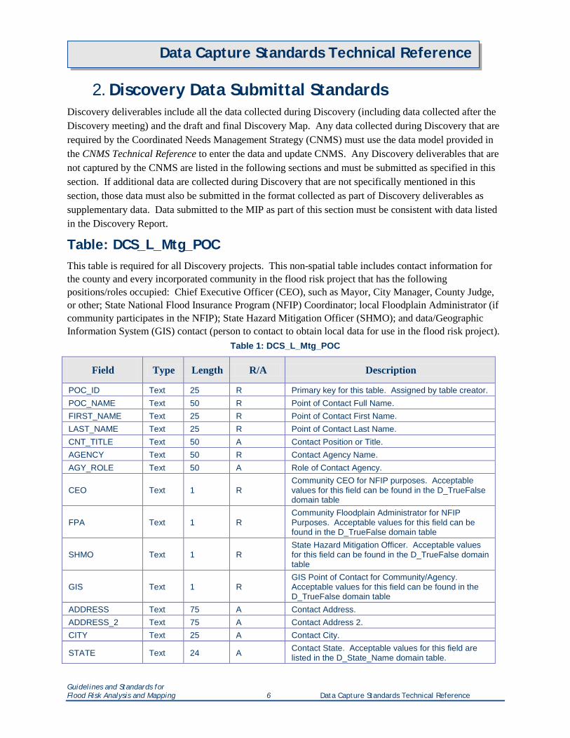
2. Discovery Data Submittal Standards Discovery deliverables include all the data collected during Discovery (including data collected after the Discovery meeting) and the draft and final Discovery Map. Any data collected during Discovery that are required by the Coordinated Needs Management Strategy (CNMS) must use the data model provided in the CNMS Technical Reference to enter the data and update CNMS. Any Discovery deliverables that are not captured by the CNMS are listed in the following sections and must be submitted as specified in this section. If additional data are collected during Discovery that are not specifically mentioned in this section, those data must also be submitted in the format collected as part of Discovery deliverables as supplementary data. Data submitted to the MIP as part of this section must be consistent with data listed in the Discovery Report.
Table: DCS_L_Mtg_POC This table is required for all Discovery projects. This non-spatial table includes contact information for the county and every incorporated community in the flood risk project that has the following positions/roles occupied: Chief Executive Officer (CEO), such as Mayor, City Manager, County Judge, or other; State National Flood Insurance Program (NFIP) Coordinator; local Floodplain Administrator (if community participates in the NFIP); State Hazard Mitigation Officer (SHMO); and data/Geographic Information System (GIS) contact (person to contact to obtain local data for use in the flood risk project).
Table 1: DCS_L_Mtg_POC
Field Type Length R/A Description
POC_ID Text 25 R Primary key for this table. Assigned by table creator. POC_NAME Text 50 R Point of Contact Full Name. FIRST_NAME Text 25 R Point of Contact First Name. LAST_NAME Text 25 R Point of Contact Last Name. CNT_TITLE Text 50 A Contact Position or Title. AGENCY Text 50 R Contact Agency Name. AGY_ROLE Text 50 A Role of Contact Agency.
CEO Text 1 R Community CEO for NFIP purposes. Acceptable values for this field can be found in the D_TrueFalse domain table
FPA Text 1 R Community Floodplain Administrator for NFIP Purposes. Acceptable values for this field can be found in the D_TrueFalse domain table
SHMO Text 1 R State Hazard Mitigation Officer. Acceptable values for this field can be found in the D_TrueFalse domain table
GIS Text 1 R GIS Point of Contact for Community/Agency. Acceptable values for this field can be found in the D_TrueFalse domain table
ADDRESS Text 75 A Contact Address. ADDRESS_2 Text 75 A Contact Address 2. CITY Text 25 A Contact City.
STATE Text 24 A Contact State. Acceptable values for this field are listed in the D_State_Name domain table.
Guidelines and Standards for Flood Risk Analysis and Mapping 6 Data Capture Standards Technical Reference
Data Capture Standards Technical Reference
Field Type Length R/A Description
ZIP Text 10 A Contact Zip Code.
PHONE Text 10 A Contact Primary Phone Number. Only numbers ( i.e. 3035551212).
PHONE_EXT Text 6 A Contact Primary Phone Number Extension. For example, x2345.
EMAIL Text 50 A Contact E-mail Address. COMMENTS Text 254 A User provided comments.
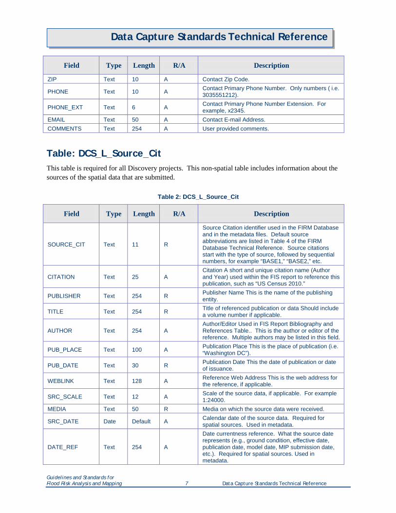
Table: DCS_L_Source_Cit This table is required for all Discovery projects. This non-spatial table includes information about the sources of the spatial data that are submitted.
Table 2: DCS_L_Source_Cit
Field Type Length R/A Description
SOURCE_CIT Text 11 R
Source Citation identifier used in the FIRM Database and in the metadata files. Default source abbreviations are listed in Table 4 of the FIRM Database Technical Reference. Source citations start with the type of source, followed by sequential numbers, for example “BASE1,” “BASE2,” etc.
CITATION Text 25 A Citation A short and unique citation name (Author and Year) used within the FIS report to reference this publication, such as “US Census 2010.”
PUBLISHER Text 254 R Publisher Name This is the name of the publishing entity.
TITLE Text 254 R Title of referenced publication or data Should include a volume number if applicable.
AUTHOR Text 254 A Author/Editor Used in FIS Report Bibliography and References Table.. This is the author or editor of the reference. Multiple authors may be listed in this field.
PUB_PLACE Text 100 A Publication Place This is the place of publication (i.e. “Washington DC”).
PUB_DATE Text 30 R Publication Date This the date of publication or date of issuance.
WEBLINK Text 128 A Reference Web Address This is the web address for the reference, if applicable.
SRC_SCALE Text 12 A Scale of the source data, if applicable. For example 1:24000.
MEDIA Text 50 R Media on which the source data were received.
SRC_DATE Date Default A Calendar date of the source data. Required for spatial sources. Used in metadata.
DATE_REF Text 254 A
Date currentness reference. What the source date represents (e.g., ground condition, effective date, publication date, model date, MIP submission date, etc.). Required for spatial sources. Used in metadata.
Guidelines and Standards for Flood Risk Analysis and Mapping 7 Data Capture Standards Technical Reference
Data Capture Standards Technical Reference
Field Type Length R/A Description
CONTRIB Text 254 A Source contribution. Information contributed by the source to the data set. Required for spatial sources. Used in metadata.
NOTES Text 254 A User Defined Notes.
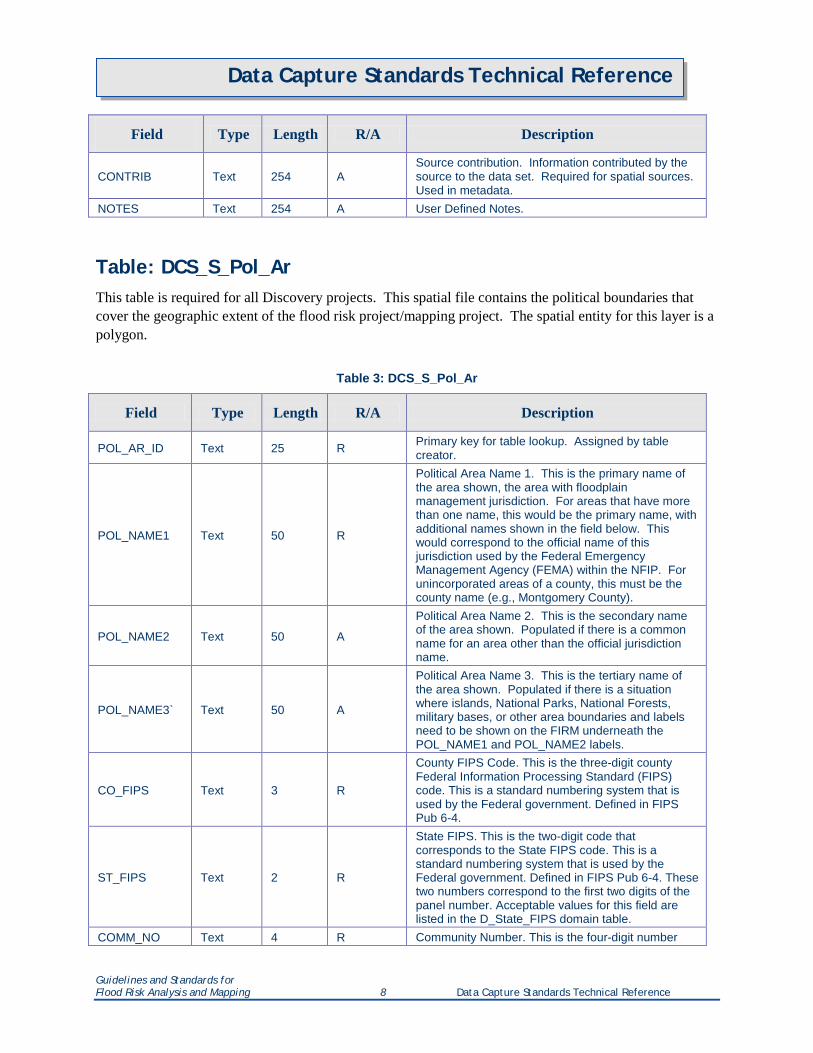
Table: DCS_S_Pol_Ar This table is required for all Discovery projects. This spatial file contains the political boundaries that cover the geographic extent of the flood risk project/mapping project. The spatial entity for this layer is a polygon.
Table 3: DCS_S_Pol_Ar
Field Type Length R/A Description
POL_AR_ID Text 25 R Primary key for table lookup. Assigned by table creator.
POL_NAME1 Text 50 R
Political Area Name 1. This is the primary name of the area shown, the area with floodplain management jurisdiction. For areas that have more than one name, this would be the primary name, with additional names shown in the field below. This would correspond to the official name of this jurisdiction used by the Federal Emergency Management Agency (FEMA) within the NFIP. For unincorporated areas of a county, this must be the county name (e.g., Montgomery County).
POL_NAME2 Text 50 A
Political Area Name 2. This is the secondary name of the area shown. Populated if there is a common name for an area other than the official jurisdiction name.
POL_NAME3` Text 50 A
Political Area Name 3. This is the tertiary name of the area shown. Populated if there is a situation where islands, National Parks, National Forests, military bases, or other area boundaries and labels need to be shown on the FIRM underneath the POL_NAME1 and POL_NAME2 labels.
CO_FIPS Text 3 R
County FIPS Code. This is the three-digit county Federal Information Processing Standard (FIPS) code. This is a standard numbering system that is used by the Federal government. Defined in FIPS Pub 6-4.
ST_FIPS Text 2 R
State FIPS. This is the two-digit code that corresponds to the State FIPS code. This is a standard numbering system that is used by the Federal government. Defined in FIPS Pub 6-4. These two numbers correspond to the first two digits of the panel number. Acceptable values for this field are listed in the D_State_FIPS domain table.
COMM_NO Text 4 R Community Number. This is the four-digit number
Guidelines and Standards for Flood Risk Analysis and Mapping 8 Data Capture Standards Technical Reference
Data Capture Standards Technical Reference
Field Type Length R/A Description
assigned by FEMA to each community for tracking purposes under the NFIP. On newer FIRMs the State FIPS and the community number appear below the community name.
CID Text 6 R
Community Identification Number. This is the six-digit community identification number assigned by FEMA. It is created by combining the State FIPS code with the COMM_NO. If the jurisdiction does not have a community number assigned by FEMA, the CID is created by combining the State FIPS code with the abbreviation contained in the COMM_NO field (FED, ST, or OTHR).
ANI_TF Text 1 R Area Not Included. Acceptable values for this field are listed in the D_TrueFalse domain table.
ANI_FIRM Text 6 A
Used for Area Not Included polygons where ANI_TF equals “T” and where the data is included in another FIRM Database, usually because it is a multicounty community. Enter the DFIRM_ID of the FIRM Database that contains the SFHA data of the ANI community. For a single-jurisdiction flood risk project, the value is composed of the 2-digit state FIPS code and the 4-digit FEMA CID code (e.g., 480001). For a countywide flood risk project, the value is composed of the 2-digit state FIPS code, the 3-digit county FIPS code, and the letter “C” (e.g., 48107C). Populate with “NP” if the area has never been converted to a FIRM Database from paper FIRM format.
SOURCE_CIT Text 11 R
Source Citation. Abbreviation used in the metadata file when describing the source information for the feature. The abbreviation must match a value in the DCS_L_Source_Cit table.
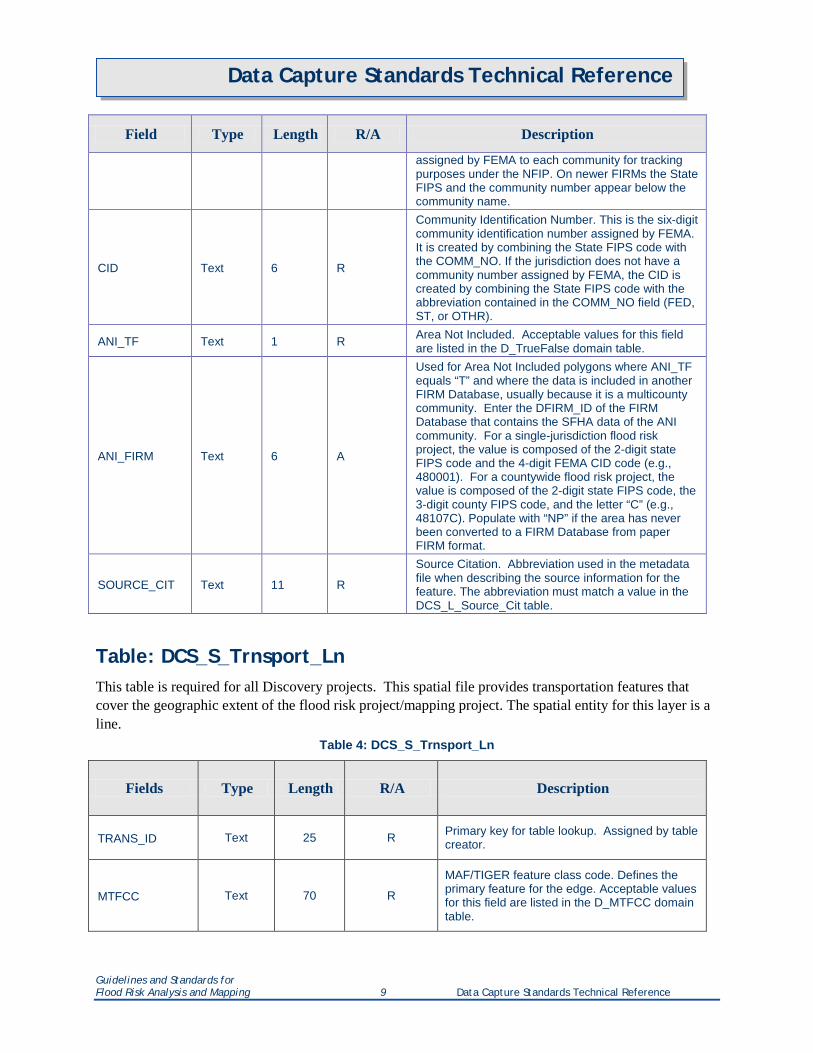
Table: DCS_S_Trnsport_Ln This table is required for all Discovery projects. This spatial file provides transportation features that cover the geographic extent of the flood risk project/mapping project. The spatial entity for this layer is a line.
Table 4: DCS_S_Trnsport_Ln
Fields Type Length R/A Description
TRANS_ID Text 25 R Primary key for table lookup. Assigned by table creator.
MTFCC Text 70 R
MAF/TIGER feature class code. Defines the primary feature for the edge. Acceptable values for this field are listed in the D_MTFCC domain table.
Guidelines and Standards for Flood Risk Analysis and Mapping 9 Data Capture Standards Technical Reference
Data Capture Standards Technical Reference
Fields Type Length R/A Description
FULLNAME Text 100 R
Full name of feature. Concatenation of expanded text for prefix, qualifier, prefix direction, prefix type, basemap name, suffix type, suffix direction, and suffix qualifier (as available) with a space between each expanded text field. This is the primary name of the feature. For areas that have more than one name, this would be the primary name with subsequent names shown in fields below. Route numbers and “Intercoastal Waterway” would also be included in this item.
ALTNAME1 Text 100 A First alternative name of feature. This is the secondary name of the feature.
ALTNAME2 Text 100 A Second alternative name of feature. This is the tertiary name of the feature.
SOURCE_CIT Text 11 R
Source Citation. Abbreviation used in the metadata file when describing the source information for the feature. The abbreviation must match a value in the DCS_L_Source_Cit table.
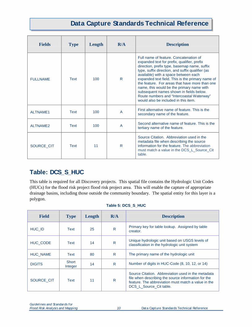
Table: DCS_S_HUC This table is required for all Discovery projects. This spatial file contains the Hydrologic Unit Codes (HUCs) for the flood risk project flood risk project area. This will enable the capture of appropriate drainage basins, including those outside the community boundary. The spatial entity for this layer is a polygon.
Table 5: DCS_S_HUC
Field Type Length R/A Description
HUC_ID Text 25 R Primary key for table lookup. Assigned by table creator.
HUC_CODE Text 14 R Unique hydrologic unit based on USGS levels of classification in the hydrologic unit system
HUC_NAME Text 80 R The primary name of the hydrologic unit
DIGITS Short Integer 14 R Number of digits in HUC-Code (8, 10, 12, or 14)
SOURCE_CIT Text 11 R
Source Citation. Abbreviation used in the metadata file when describing the source information for the feature. The abbreviation must match a value in the DCS_L_Source_Cit table.
Guidelines and Standards for Flood Risk Analysis and Mapping 10 Data Capture Standards Technical Reference
Data Capture Standards Technical Reference
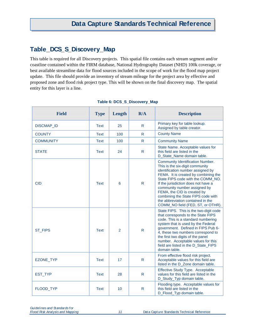
Table_DCS_S_Discovery_Map This table is required for all Discovery projects. This spatial file contains each stream segment and/or coastline contained within the FIRM database, National Hydrography Dataset (NHD) 100k coverage, or best available streamline data for flood sources included in the scope of work for the flood map project update. This file should provide an inventory of stream mileage for the project area by effective and proposed zone and flood risk project type. This will be shown on the final discovery map. The spatial entity for this layer is a line.
Table 6: DCS_S_Discovery_Map
Field Type Length R/A Description
DISCMAP_ID Text 25 R Primary key for table lookup. Assigned by table creator.
COUNTY Text 100 R County Name
COMMUNITY Text 100 R Community Name
STATE Text 24 R State Name. Acceptable values for this field are listed in the D_State_Name domain table.
CID Text 6 R
Community Identification Number. This is the six-digit community identification number assigned by FEMA. It is created by combining the State FIPS code with the COMM_NO. If the jurisdiction does not have a community number assigned by FEMA, the CID is created by combining the State FIPS code with the abbreviation contained in the COMM_NO field (FED, ST, or OTHR).
ST_FIPS Text 2 R
State FIPS. This is the two-digit code that corresponds to the State FIPS code. This is a standard numbering system that is used by the Federal government. Defined in FIPS Pub 6-4, these two numbers correspond to the first two digits of the panel number. Acceptable values for this field are listed in the D_State_FIPS domain table.
EZONE_TYP Text 17 R From effective flood risk project. Acceptable values for this field are listed in the D_Zone domain table.
EST_TYP Text 28 R Effective Study Type. Acceptable values for this field are listed in the D_Study_Typ domain table.
FLOOD_TYP Text 10 R Flooding type. Acceptable values for this field are listed in the D_Flood_Typ domain table.
Guidelines and Standards for Flood Risk Analysis and Mapping 11 Data Capture Standards Technical Reference
Data Capture Standards Technical Reference
Field Type Length R/A Description
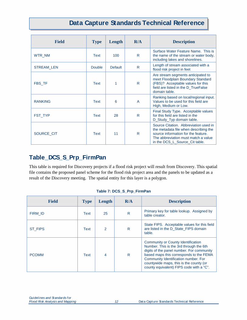
WTR_NM Text 100 R Surface Water Feature Name. This is the name of the stream or water body, including lakes and shorelines.
STREAM_LEN Double Default R Length of stream associated with a flood risk project in feet
FBS_TF Text 1 R
Are stream segments anticipated to meet Floodplain Boundary Standard (FBS)? Acceptable values for this field are listed in the D_TrueFalse domain table.
RANKING Text 6 A Ranking based on local/regional input. Values to be used for this field are High, Medium or Low.
FST_TYP Text 28 R Final Study Type. Acceptable values for this field are listed in the D_Study_Typ domain table.
SOURCE_CIT Text 11 R
Source Citation. Abbreviation used in the metadata file when describing the source information for the feature. The abbreviation must match a value in the DCS_L_Source_Cit table.
Table_DCS_S_Prp_FirmPan This table is required for Discovery projects if a flood risk project will result from Discovery. This spatial file contains the proposed panel scheme for the flood risk project area and the panels to be updated as a result of the Discovery meeting. The spatial entity for this layer is a polygon.
Table 7: DCS_S_Prp_FirmPan
Field Type Length R/A Description
FIRM_ID Text 25 R Primary key for table lookup. Assigned by table creator.
ST_FIPS Text 2 R State FIPS. Acceptable values for this field are listed in the D_State_FIPS domain table.
PCOMM Text 4 R
Community or County Identification Number. This is the 3rd through the 6th digits of the panel number. For community based maps this corresponds to the FEMA Community Identification number. For countywide maps, this is the county (or county equivalent) FIPS code with a “C”.
Guidelines and Standards for Flood Risk Analysis and Mapping 12 Data Capture Standards Technical Reference
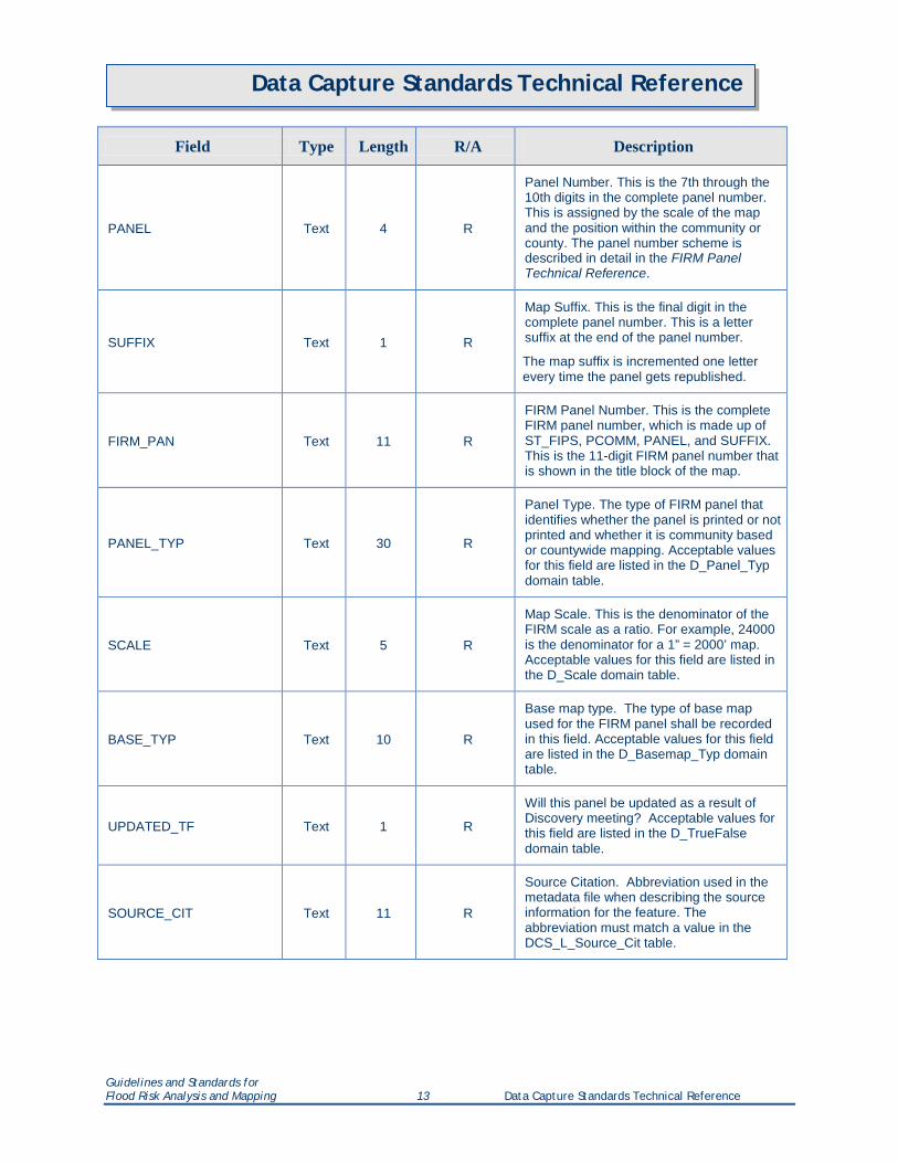
Data Capture Standards Technical Reference
Field Type Length R/A Description
PANEL Text 4 R
Panel Number. This is the 7th through the 10th digits in the complete panel number. This is assigned by the scale of the map and the position within the community or county. The panel number scheme is described in detail in the FIRM Panel Technical Reference.
SUFFIX Text 1 R
Map Suffix. This is the final digit in the complete panel number. This is a letter suffix at the end of the panel number.
The map suffix is incremented one letter every time the panel gets republished.
FIRM_PAN Text 11 R
FIRM Panel Number. This is the complete FIRM panel number, which is made up of ST_FIPS, PCOMM, PANEL, and SUFFIX. This is the 11-digit FIRM panel number that is shown in the title block of the map.
PANEL_TYP Text 30 R
Panel Type. The type of FIRM panel that identifies whether the panel is printed or not printed and whether it is community based or countywide mapping. Acceptable values for this field are listed in the D_Panel_Typ domain table.
SCALE Text 5 R
Map Scale. This is the denominator of the FIRM scale as a ratio. For example, 24000 is the denominator for a 1” = 2000’ map. Acceptable values for this field are listed in the D_Scale domain table.
BASE_TYP Text 10 R
Base map type. The type of base map used for the FIRM panel shall be recorded in this field. Acceptable values for this field are listed in the D_Basemap_Typ domain table.
UPDATED_TF Text 1 R
Will this panel be updated as a result of Discovery meeting? Acceptable values for this field are listed in the D_TrueFalse domain table.
SOURCE_CIT Text 11 R
Source Citation. Abbreviation used in the metadata file when describing the source information for the feature. The abbreviation must match a value in the DCS_L_Source_Cit table.
Guidelines and Standards for Flood Risk Analysis and Mapping 13 Data Capture Standards Technical Reference
Data Capture Standards Technical Reference
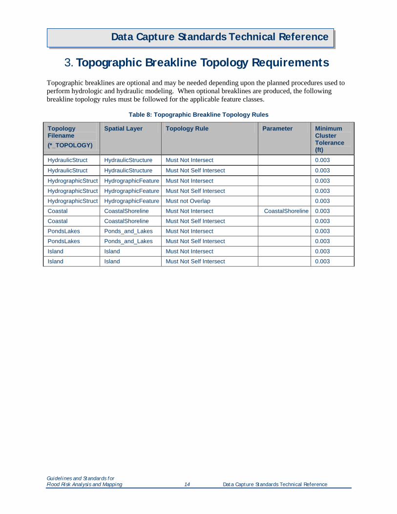
3. Topographic Breakline Topology Requirements
Topographic breaklines are optional and may be needed depending upon the planned procedures used to perform hydrologic and hydraulic modeling. When optional breaklines are produced, the following breakline topology rules must be followed for the applicable feature classes.
Table 8: Topographic Breakline Topology Rules
Topology Filename (*_TOPOLOGY)
Spatial Layer Topology Rule Parameter Minimum Cluster Tolerance (ft)
HydraulicStruct HydraulicStructure Must Not Intersect 0.003
HydraulicStruct HydraulicStructure Must Not Self Intersect 0.003
HydrographicStruct HydrographicFeature Must Not Intersect 0.003
HydrographicStruct HydrographicFeature Must Not Self Intersect 0.003
HydrographicStruct HydrographicFeature Must not Overlap 0.003
Coastal CoastalShoreline Must Not Intersect CoastalShoreline 0.003
Coastal CoastalShoreline Must Not Self Intersect 0.003
PondsLakes Ponds_and_Lakes Must Not Intersect 0.003
PondsLakes Ponds_and_Lakes Must Not Self Intersect 0.003
Island Island Must Not Intersect 0.003
Island Island Must Not Self Intersect 0.003
Guidelines and Standards for Flood Risk Analysis and Mapping 14 Data Capture Standards Technical Reference
Data Capture Standards Technical Reference
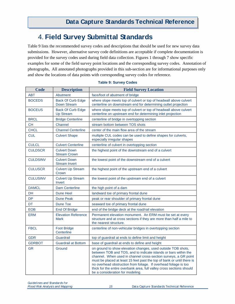
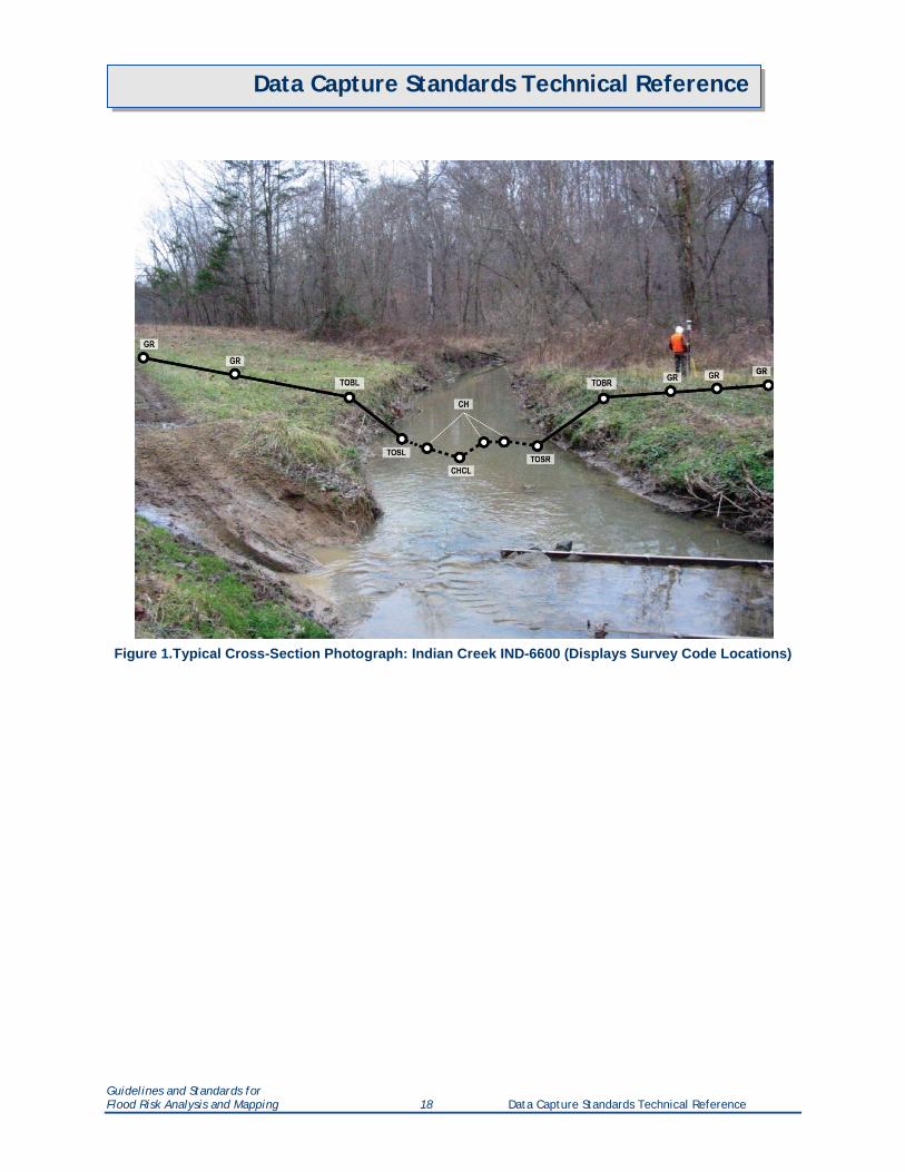
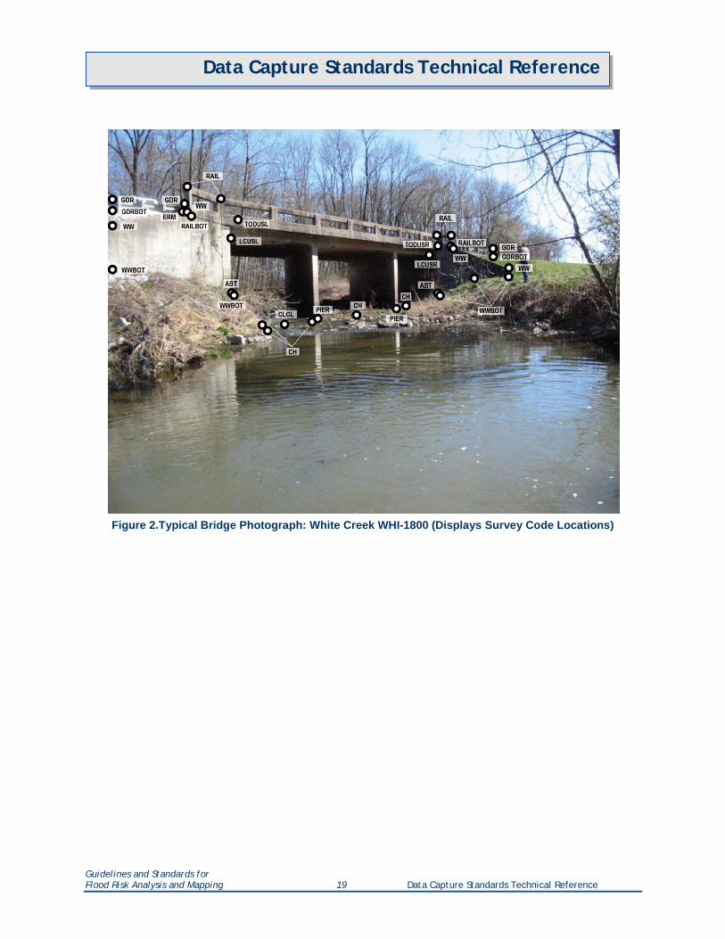
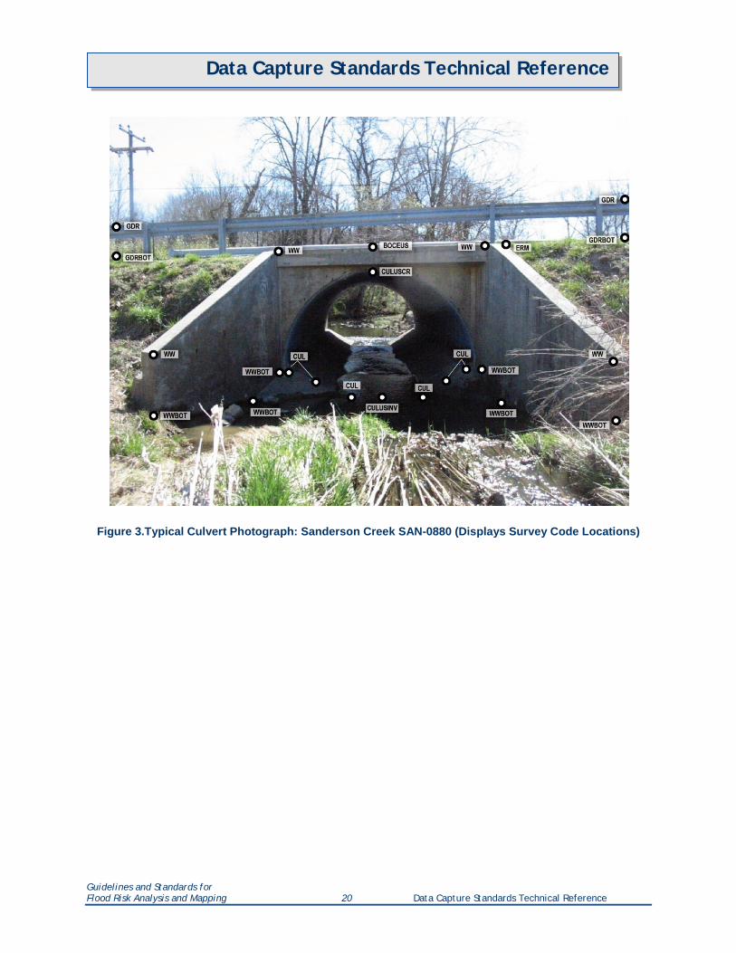
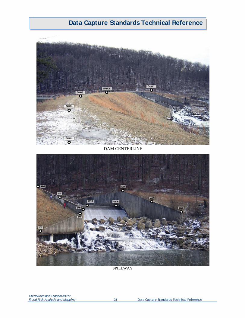
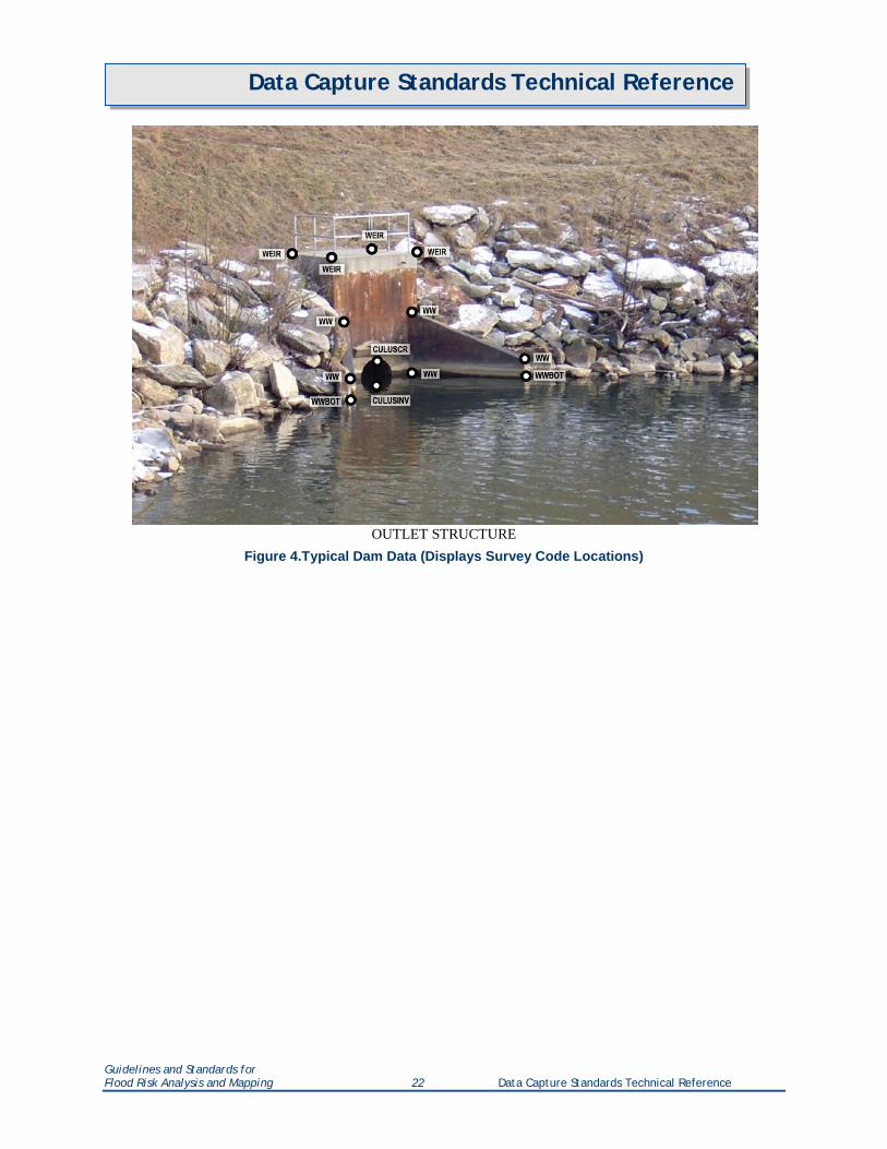
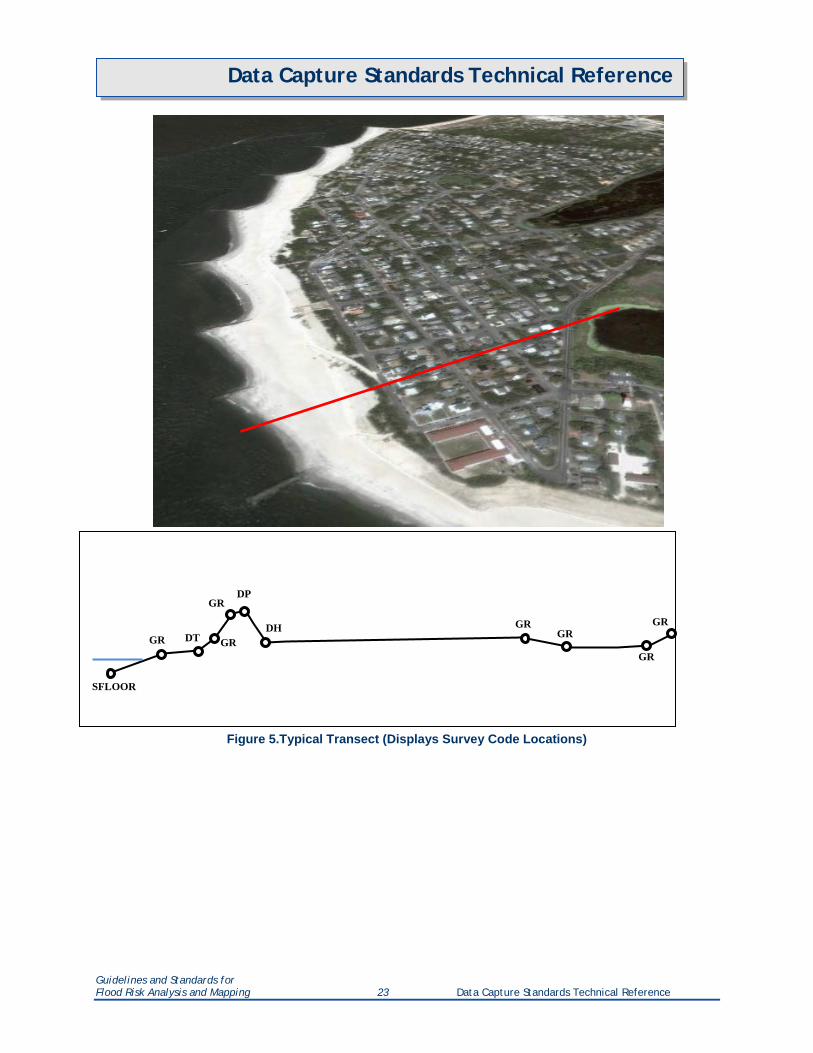
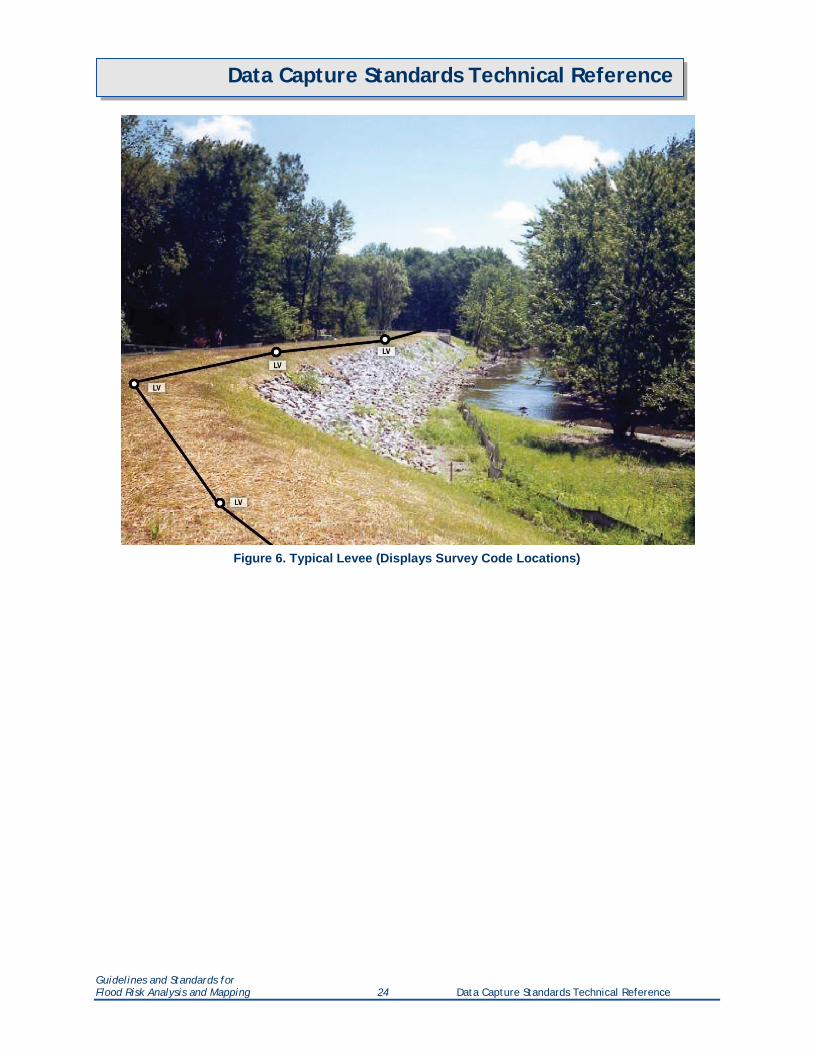
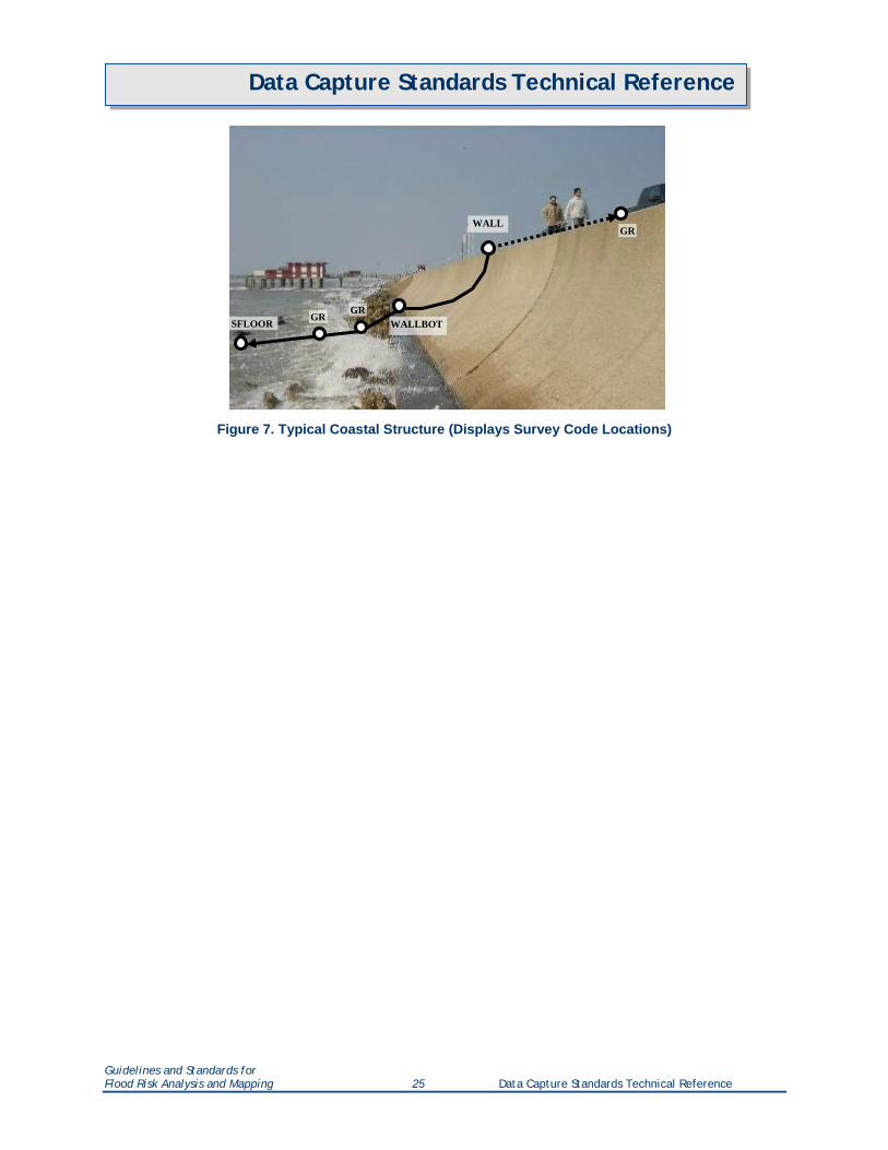
4. Field Survey Submittal Standards Table 9 lists the recommended survey codes and descriptions that should be used for new survey data submissions. However, alternative survey code definitions are acceptable if complete documentation is provided for the survey codes used during field data collection. Figures 1 through 7 show specific examples for some of the field survey point locations and the corresponding survey codes. Annotation of photographs, All annotated photographs provided in this sub-section are for informational purposes only and show the locations of data points with corresponding survey codes for reference.
Table 9: Survey Codes
Code Description Field Survey Location ABT Abutment face/foot of abutment of bridge BOCEDS Back Of Curb Edge
Down Stream where slope meets top of culvert or top of headwall above culvert centerline on downstream end for determining outlet projection
BOCEUS Back Of Curb Edge Up Stream
where slope meets top of culvert or top of headwall above culvert centerline on upstream end for determining inlet projection
BRCL Bridge Centerline centerline of bridge in overtopping section CH Channel stream bottom between TOS shots CHCL Channel Centerline center of the main flow area of the stream CUL Culvert Shape multiple CUL codes can be used to define shapes for culverts,
especially irregular shapes CULCL Culvert Centerline centerline of culvert in overtopping section CULDSCR Culvert Down
Stream Crown the highest point of the downstream end of a culvert
CULDSINV Culvert Down Stream Invert
the lowest point of the downstream end of a culvert
CULUSCR Culvert Up Stream Crown
the highest point of the upstream end of a culvert
CULUSINV Culvert Up Stream Invert
the lowest point of the upstream end of a culvert
DAMCL Dam Centerline the high point of a dam DH Dune Heel landward toe of primary frontal dune DP Dune Peak peak or rear shoulder of primary frontal dune DT Dune Toe seaward toe of primary frontal dune EOB End Of Bridge end of the bridge deck at the road/rail elevation ERM Elevation Reference
Mark Permanent elevation monument. An ERM must be set at every structure and at cross sections if they are more than half a mile to the nearest structure.
FBCL Foot Bridge Centerline
centerline of non-vehicular bridges in overtopping section
GDR Guardrail top of guardrail at ends to define limit and height GDRBOT Guardrail at Bottom base of guardrail at ends to define and height GR Ground on ground to show elevation changes, used outside TOB shots,
between TOB and TOS, and to indicate islands or bars within the channel. When used in channel cross-section surveys, a GR point must be placed at least 15 feet past the top of bank or until there is no overhead obstruction from foliage. If overhead foliage is too thick for the entire overbank area, full valley cross sections should be a consideration for modeling.
Guidelines and Standards for Flood Risk Analysis and Mapping 15 Data Capture Standards Technical Reference
Data Capture Standards Technical Reference
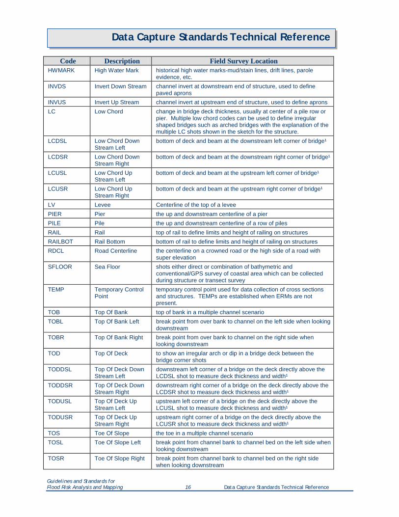
Code Description Field Survey Location HWMARK High Water Mark historical high water marks-mud/stain lines, drift lines, parole
evidence, etc. INVDS Invert Down Stream channel invert at downstream end of structure, used to define
paved aprons INVUS Invert Up Stream channel invert at upstream end of structure, used to define aprons LC Low Chord change in bridge deck thickness, usually at center of a pile row or
pier. Multiple low chord codes can be used to define irregular shaped bridges such as arched bridges with the explanation of the multiple LC shots shown in the sketch for the structure.
LCDSL Low Chord Down Stream Left
bottom of deck and beam at the downstream left corner of bridge¹
LCDSR Low Chord Down Stream Right
bottom of deck and beam at the downstream right corner of bridge¹
LCUSL Low Chord Up Stream Left
bottom of deck and beam at the upstream left corner of bridge¹
LCUSR Low Chord Up Stream Right
bottom of deck and beam at the upstream right corner of bridge¹
LV Levee Centerline of the top of a levee PIER Pier the up and downstream centerline of a pier PILE Pile the up and downstream centerline of a row of piles RAIL Rail top of rail to define limits and height of railing on structures RAILBOT Rail Bottom bottom of rail to define limits and height of railing on structures RDCL Road Centerline the centerline on a crowned road or the high side of a road with
super elevation SFLOOR Sea Floor shots either direct or combination of bathymetric and
conventional/GPS survey of coastal area which can be collected during structure or transect survey
TEMP Temporary Control Point
temporary control point used for data collection of cross sections and structures. TEMPs are established when ERMs are not present.
TOB Top Of Bank top of bank in a multiple channel scenario TOBL Top Of Bank Left break point from over bank to channel on the left side when looking
downstream TOBR Top Of Bank Right break point from over bank to channel on the right side when
looking downstream TOD Top Of Deck to show an irregular arch or dip in a bridge deck between the
bridge corner shots TODDSL Top Of Deck Down
Stream Left downstream left corner of a bridge on the deck directly above the LCDSL shot to measure deck thickness and width¹
TODDSR Top Of Deck Down Stream Right
downstream right corner of a bridge on the deck directly above the LCDSR shot to measure deck thickness and width¹
TODUSL Top Of Deck Up Stream Left
upstream left corner of a bridge on the deck directly above the LCUSL shot to measure deck thickness and width¹
TODUSR Top Of Deck Up Stream Right
upstream right corner of a bridge on the deck directly above the LCUSR shot to measure deck thickness and width¹
TOS Toe Of Slope the toe in a multiple channel scenario TOSL Toe Of Slope Left break point from channel bank to channel bed on the left side when
looking downstream TOSR Toe Of Slope Right break point from channel bank to channel bed on the right side
when looking downstream
Guidelines and Standards for Flood Risk Analysis and Mapping 16 Data Capture Standards Technical Reference
Data Capture Standards Technical Reference
Code Description Field Survey Location WALL Wall top of a retaining wall, also used outside TOBL and TOBR when
the stream banks are vertical walls or rock cuts WALLBOT Wall Bottom bottom of a retaining wall, also used outside TOBL and TOBR
when the stream banks are vertical walls or rock cuts WEIR Weir top of dam spillways and outlet structures. Multiple weir codes may
be used to collect data for gates, flashboards, and other operable structures. The explanation of the multiple shots must be shown in the structure sketch.
WW Wing Wall top face of each end of a wing wall or headwall on a structure to define height and length
WWBOT Wing Wall Bottom base of each end of a wing wall or head wall on a structure to define height and length
¹ The four bridge corner shots need to be taken outside of any rail to accurately measure hydraulic length.
Guidelines and Standards for Flood Risk Analysis and Mapping 17 Data Capture Standards Technical Reference
Data Capture Standards Technical Reference
Figure 1.Typical Cross-Section Photograph: Indian Creek IND-6600 (Displays Survey Code Locations)
Guidelines and Standards for Flood Risk Analysis and Mapping 18 Data Capture Standards Technical Reference
Data Capture Standards Technical Reference
Figure 2.Typical Bridge Photograph: White Creek WHI-1800 (Displays Survey Code Locations)
Guidelines and Standards for Flood Risk Analysis and Mapping 19 Data Capture Standards Technical Reference
Data Capture Standards Technical Reference
Figure 3.Typical Culvert Photograph: Sanderson Creek SAN-0880 (Displays Survey Code Locations)
Guidelines and Standards for Flood Risk Analysis and Mapping 20 Data Capture Standards Technical Reference
Data Capture Standards Technical Reference
DAM CENTERLINE
SPILLWAY
Guidelines and Standards for Flood Risk Analysis and Mapping 21 Data Capture Standards Technical Reference
Data Capture Standards Technical Reference
OUTLET STRUCTURE
Figure 4.Typical Dam Data (Displays Survey Code Locations)
Guidelines and Standards for Flood Risk Analysis and Mapping 22 Data Capture Standards Technical Reference
Data Capture Standards Technical Reference
Figure 5.Typical Transect (Displays Survey Code Locations)
SFLOOR
GR GR
GR
DT
DP
DH GR GR
GR
GR
Guidelines and Standards for Flood Risk Analysis and Mapping 23 Data Capture Standards Technical Reference
Data Capture Standards Technical Reference
Figure 6. Typical Levee (Displays Survey Code Locations)
Guidelines and Standards for Flood Risk Analysis and Mapping 24 Data Capture Standards Technical Reference
Data Capture Standards Technical Reference
Figure 7. Typical Coastal Structure (Displays Survey Code Locations)
SFLOOR GR
WALLBOT
WALL
GR
GR
Guidelines and Standards for Flood Risk Analysis and Mapping 25 Data Capture Standards Technical Reference
Data Capture Standards Technical Reference
5. Deliverables
Final Regulatory Products The required documents that make up the final regulatory products package include the following items. They must be in the digital format and directory structure indicated below and in Section 6. The final paperwork (Transmittal Form, Transmittal Letters, Inventory Worksheets, and CMAL) are currently submitted electronically to the Map Service Center (MSC) via email, FTP, or Sharepoint. The remaining deliverables (FIS Report, FIRM Scans, FIRM Database, Metadata, Orthophotos) are submitted to the MIP and to the MSC on media (i.e., CD/DVD). In the future, all data will be submitted to the MIP only.
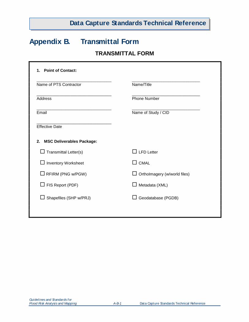
Transmittal Form
The transmittal form provides a listing of all of the items being submitted to the MSC. It is designed as a checklist to ensure that all contents that constitute the MSC Deliverables Package are included with the submittal to the MSC. The Transmittal Form must be provided in Microsoft Word format. See Appendix B for a sample transmittal form.
Transmittal to Community CEO
A transmittal letter to the community CEO (179 Letter) is sent by the MSC to each community, along with the final mapping products distributed by the MSC. Refer to Appendix A of the Document Control Procedures Manual for the current letter templates.
There must be one letter for each community that appears on a printed map panel of the flood insurance study. For Physical Map Revisions, only communities that lie or appear on a revised printed map panel will receive a letter. The letter must include the current (as of the date the post-preliminary study deliverables are prepared) CEO’s name and address, the six-digit community identification number, and the effective date. Each letter must be provided in Microsoft Word format.
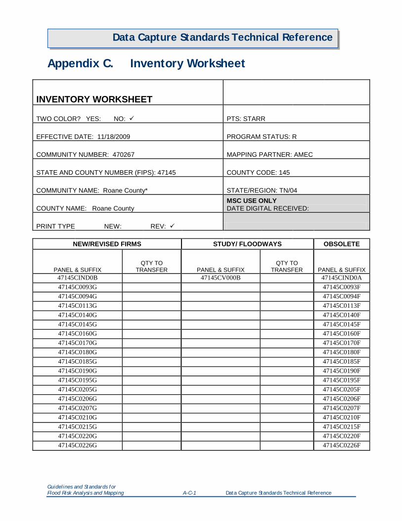
Inventory Worksheet for Each Community
The Inventory Worksheet is used by the MSC to update the MSC inventory and management information systems. Every community— including the Unincorporated Areas, the countywide or all-jurisdictions mapping number, if applicable, and mapped non-flood-prone and non-participating communities—requires a separate Inventory Worksheet. The Inventory Worksheet must be provided in Microsoft Excel format (XLS/XLSX). The formatting of the standard Inventory Worksheet template must not be modified or otherwise altered. See Appendix C for a sample Inventory Worksheet.
Community Map Action List (CMAL)
One copy of the CMAL must accompany each submission to the MSC; however, several communities may be shown on one CMAL, provided that the FIRMs have the same effective date. Each CMAL should list all the communities within the county, including the non-flood-prone communities . Areas Not Included should not be listed. For Physical Map Revisions, only communities that lie or appear on a revised printed map panel should be listed in the CMAL. The CMAL must be provided in Microsoft
Guidelines and Standards for Flood Risk Analysis and Mapping 26 Data Capture Standards Technical Reference
Data Capture Standards Technical Reference
Excel format (XLS/XLSX). See Appendix D for a Community Map Action List and sample. For a more detailed list of the CMAL codes, see Appendix E.
FIS Report
The FIS report must be submitted in digital format as an unsecure PDF file, with a resolution of 400 dpi. There must be one PDF file per FIS volume that is bookmarked at each of the major headings shown within the table of contents (minimum), and at the start of each flooding source’s profile (subject to cost and project-officer approval). The FIS report must also be submitted in Word format and the profiles must be submitted as CADD files (DXF, DWG) or in a RAS-Plot database. The FIS report must conform to the requirements of the FIS Report Technical Reference.
The PDF version of the FIS report must be named <ST_FIPS><PCOMM><VOLUME NUMBER>.pdf. The Word file should conform to the same naming convention.
Examples:
24031CV000B.pdf – Single volume countywide FIS
120234V001A. pdf – Community FIS Volume 1 of 2
120234V002A.pdf – Community FIS Volume 2 of 2
24031CV000B.docx – Single volume countywide FIS
120234V001A.docx– Community FIS Volume 1 of 2
120234V002.docx – Community FIS Volume 2 of 2
FIRM Scans and World Files
FIRM Scans are the raster images of the FIRM panels and Map Index. The FIRM Scans must be georeferenced. The FIRM Scanos of the FIRM panels must conform to the requirements of the FIRM Panel Technical Reference. The FIRM Scans of the Map Index must conform to the requirements of the Flood Insurance Study (FIS) Technical Reference. The FIRM Scans must be named according to the map number shown on the titleblock of the FIRM panel or Map Index. Color images must be 400 DPI, 24 bit PNG. All images must be accompanied by their world file. The MXD files used to create the FIRM Scans must also be submitted with file names that conform to the same naming convention.
Examples:
FIRM Scans
24031C0001A.png – FIRM panel
24031CIND0A.png – Map Index
World files for the image files above:
24031C0001A.pgw – FIRM panel
Guidelines and Standards for Flood Risk Analysis and Mapping 27 Data Capture Standards Technical Reference
Data Capture Standards Technical Reference
24031CIND0A.pgw – Map Index
MXD files
24031C0001A.mxd – FIRM panel
24031CIND0A.mxd – Map Index
FIRM Database
FIRM Databases must be submitted in Esri Shapefile (SHP) and Esri Personal Geodatabase (PGDB) format. The FIRM Database must conform to the requirements of the FIRM Database Technical Reference. When submitted on CD-ROM or DVD-ROM, each FIRM Database must be submitted in a single directory that contains all subordinate subdirectories. The name of this directory is designed to identify the study and whether these data represent an initial FIRM Database or revise an existing FIRM Database. The directory for an initial FIRM Database must be named <CID or County FIPS>_FIRM, while a submission that replaces a current FIRM Database must be named <CID or County FIPS>_<Alpha>_FIRM. Each subsequent revision for which there is a new effective date requires the <Alpha> character to be advanced. To determine the appropriate alpha-character, view the current effective FIRM Database listed under the FIRM Database section of MSC’s EDDie. The FIRM Database PGDB files must also conform to the same naming convention. FIRM Database Shapefiles must be named using the table names in the FIRM Database Technical Reference.
Examples:
Initial FIRM Database Submission Directory
120234_FIRM – community FIRM Database
12345C_FIRM – countywide FIRM Database
120234_A_FIRM – community FIRM Database that revises a current FIRM Database
12345C_A_FIRM – countywide FIRM Database that revises a current FIRM Database
FIRM Database
120234_FIRM.mdb – community FIRM Database
12345C_FIRM.mdb – countywide FIRM Database
120234_A_FIRM.mdb – community FIRM Database that revises a current FIRM Database
12345C_A_FIRM.mdb – countywide FIRM Database that revises a current FIRM Database
Orthophotos
The aerial images and any associated world files that were used to create the FIRM (if applicable) must be submitted. These data should be in the format in which the orthophotos were provided to the FEMA Mapping Partner, unless the appearance of any portion of the orthophotos shown on the FIRM was
Guidelines and Standards for Flood Risk Analysis and Mapping 28 Data Capture Standards Technical Reference
Data Capture Standards Technical Reference
modified by re-projection, re-sampling, etc. In this case, only the modified orthophotos should be submitted.
Metadata Files
Metadata files should be provided in xml format. The metadata files must conform to the requirements of the Metadata Profiles Technical Reference. The metadata files must be named <ST_FIPS><PCOMM>_<EFF_DATE> _metadata.xml where ST_FIPS is the two-digit state FIPS code. PCOMM is either the three-digit county FIPS code with a trailing “C” or the four-digit community number. EFF_DATE is the effective date of the study in YYYYMMDD format. Note that the metadata file name for a revised submission also requires the _<Alpha> addition to the filename. Examples:
24031C_20031217_metadata.xml – a countywide FIRM Database
241234_20031217_metadata.xml – a community FIRM Database
Final Non-Regulatory Flood Risk Assessment Products The required documents that make up the final non-regulatory Flood Risk Assessment products package include the following items. They must be in the digital format and directory structure indicated below and in Section 6.
Flood Risk Products Index
The index provides a listing of the communities covered in the FRD being submitted to the MSC. It is a table designed to ensure that all communities with data in the dataset are accurately represented on the MSC website. See Appendix F for a sample Flood Risk Products Index form. All Regions, states, counties, CIDs, and products associated with the Flood Risk Products submission should be listed.
The Transmittal Form must be provided in Microsoft Excel format. The Index for the Flood Risk Dataset must be named <FRD>_<MIP Case Number>_Index.xls
Example:
FRD_12-04-1234S_Index.xls
Flood Risk Database
Flood Risk Databases (FRDs) must be submitted in Esri Shapefile (SHP) and Esri File Geodatabase (fGDB) format. The Flood Depth and Analysis rasters must be submitted in the fGDB and in GeoTIFF format. The FRD must conform to the requirements of the Flood Risk Database Technical Reference. Each FRD must be submitted in a single directory that contains all subordinate subdirectories. The FRD must include the final Changes Since Last FIRM (CSLF) and Flood Depth and Analysis Rasters and any available Flood Risk Assessment and/or Areas of Mitigation Interest (AoMIs). The name of this directory is designed to identify the MIP case number for the FRD. The directory for an initial FRD must be named FRD_<MIP Case Number>. In the event that there will be more than one FRD for one MIP project, a suffix for each county should be used FRD_<MIP Case Number>_<FIPS Number>. The FRD fGDB file
Guidelines and Standards for Flood Risk Analysis and Mapping 29 Data Capture Standards Technical Reference
Data Capture Standards Technical Reference
name must be named FRD_<MIP Case Number>_<YYYYMMDD> where <YYYYMMDD> is the submittal date of the FRD to FEMA. FRD Shapefiles must be named using the table names in the Flood Risk Database Technical Reference. The GeoTIFF versions of the rasters must be named using the file naming convention in the Flood Risk Database Technical Reference.
Examples: Flood Risk Database Submission Directory
FRD_12-04-1234S – a MIP Project-wide FRD
FRD_12-04-1234S_12456C – a county extract of an FRD from a larger MIP Project FRD
Flood Risk Database
FRD_12-04-1234S_20130419.gdb
Metadata Files
Metadata files should be provided in xml format. The metadata files must conform to the Metadata Profiles Technical Reference. The metadata files must be named <FEMA Case Number>_<FRD >_metadata. The FEMA Case Number is a unique 9-digit number assigned to each flood risk project in yy-rr-nnnS format. Note that the metadata file name for a county FRD extract also requires the _<FIPS> addition to the filename. Examples:
FRD_12-04-1234S_metadata.xml – a MIP Project-wide FRD
FRD_12-04-1234S_metadata_12456C.xml – a county extract of an FRD
Flood Risk Report
The Flood Risk Report (FRR) must be submitted in digital format as an unsecure PDF file, with a resolution of 400 dpi. The FRR must also be submitted in Word format.
The PDF version of the FRR must be named FRR_<MIP Case Number>_<YYYYMMDD>.pdf. The <YYYMMDD> is the submittal date of the FRR to FEMA. The FRR in Word format must also conform to the same naming convention.
Examples: FRR_12-04-1234S_20130419.pdf
FRR_12-04-1234S_20130419.docx
Flood Risk Map
The Flood Risk Map (FRM) must be submitted in digital format as an unsecure PDF file, with a resolution of 400 dpi. The MXD file used to create the FRM must also be submitted.
The PDF version of the FRM must be named FRM_<MIP Case Number>_<YYYYMMDD>.pdf. The <YYYYMMDD> is the submittal date of the FRM to FEMA. The FRM in MXD format must also conform to the same naming convention.
Guidelines and Standards for Flood Risk Analysis and Mapping 30 Data Capture Standards Technical Reference
Data Capture Standards Technical Reference
Examples: FRM_12-04-1234S_20130419.pdf
FRM_12-04-1234S_20130419.mxd
Guidelines and Standards for Flood Risk Analysis and Mapping 31 Data Capture Standards Technical Reference
Data Capture Standards Technical Reference
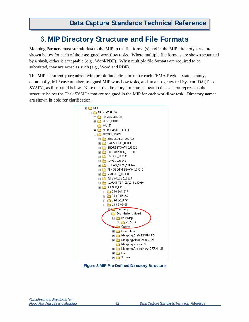
6. MIP Directory Structure and File Formats Mapping Partners must submit data to the MIP in the file format(s) and in the MIP directory structure shown below for each of their assigned workflow tasks. Where multiple file formats are shown separated by a slash, either is acceptable (e.g., Word/PDF). When multiple file formats are required to be submitted, they are noted as such (e.g., Word and PDF).
The MIP is currently organized with pre-defined directories for each FEMA Region, state, county, community, MIP case number, assigned MIP workflow tasks, and an auto-generated System ID# (Task SYSID), as illustrated below. Note that the directory structure shown in this section represents the structure below the Task SYSIDs that are assigned in the MIP for each workflow task. Directory names are shown in bold for clarification.
Figure 8 MIP Pre-Defined Directory Structure
Guidelines and Standards for Flood Risk Analysis and Mapping 32 Data Capture Standards Technical Reference
Data Capture Standards Technical Reference
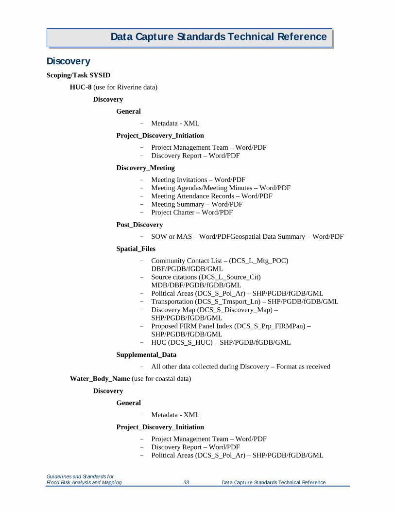
Discovery Scoping/Task SYSID
HUC-8 (use for Riverine data)
Discovery
General
- Metadata - XML
Project_Discovery_Initiation
- Project Management Team – Word/PDF - Discovery Report – Word/PDF
Discovery_Meeting
- Meeting Invitations – Word/PDF - Meeting Agendas/Meeting Minutes – Word/PDF - Meeting Attendance Records – Word/PDF - Meeting Summary – Word/PDF - Project Charter – Word/PDF
Post_Discovery
- SOW or MAS – Word/PDFGeospatial Data Summary – Word/PDF
Spatial_Files
- Community Contact List – (DCS_L_Mtg_POC) DBF/PGDB/fGDB/GML
- Source citations (DCS_L_Source_Cit) MDB/DBF/PGDB/fGDB/GML
- Political Areas (DCS_S_Pol_Ar) – SHP/PGDB/fGDB/GML - Transportation (DCS_S_Trnsport_Ln) – SHP/PGDB/fGDB/GML - Discovery Map (DCS_S_Discovery_Map) –
SHP/PGDB/fGDB/GML - Proposed FIRM Panel Index (DCS_S_Prp_FIRMPan) –
SHP/PGDB/fGDB/GML - HUC (DCS_S_HUC) – SHP/PGDB/fGDB/GML
Supplemental_Data
- All other data collected during Discovery – Format as received
Water_Body_Name (use for coastal data)
Discovery
General
- Metadata - XML
Project_Discovery_Initiation
- Project Management Team – Word/PDF - Discovery Report – Word/PDF - Political Areas (DCS_S_Pol_Ar) – SHP/PGDB/fGDB/GML
Guidelines and Standards for Flood Risk Analysis and Mapping 33 Data Capture Standards Technical Reference
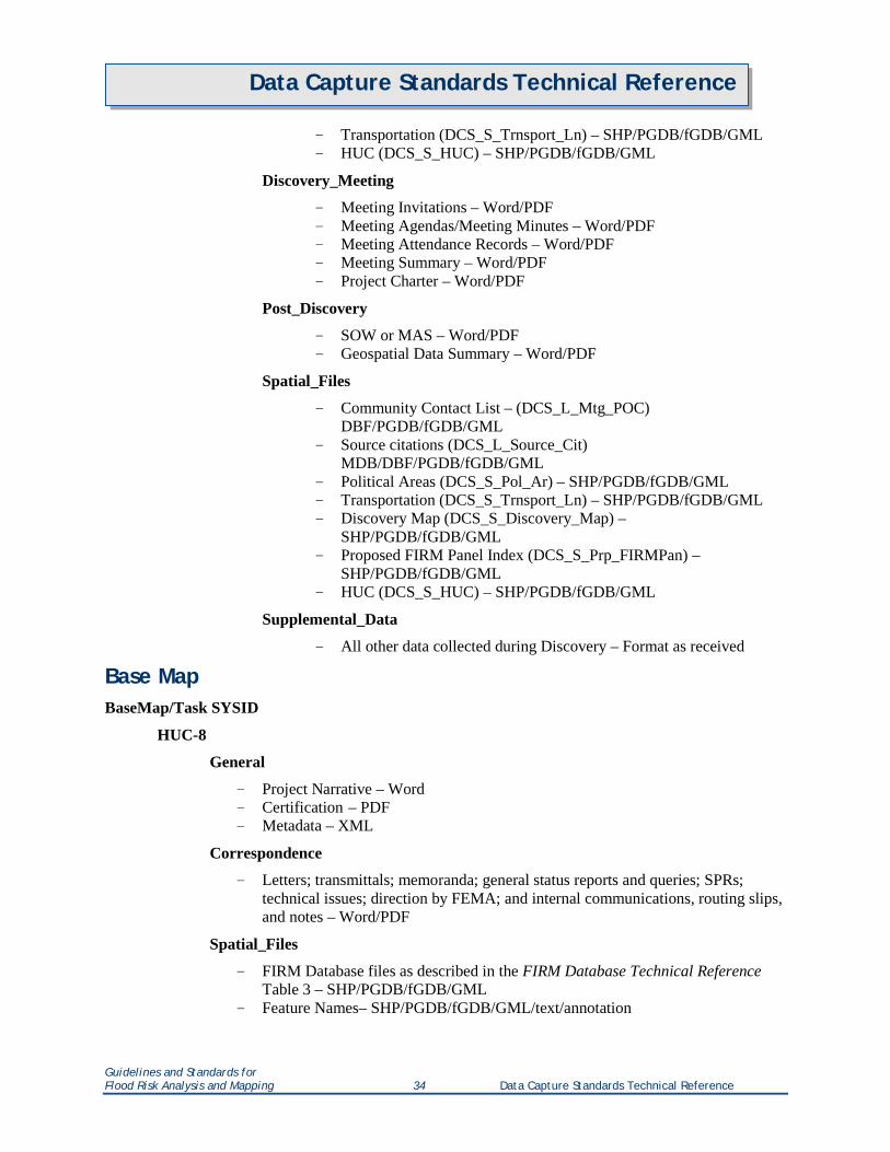
Data Capture Standards Technical Reference
- Transportation (DCS_S_Trnsport_Ln) – SHP/PGDB/fGDB/GML - HUC (DCS_S_HUC) – SHP/PGDB/fGDB/GML
Discovery_Meeting
- Meeting Invitations – Word/PDF - Meeting Agendas/Meeting Minutes – Word/PDF - Meeting Attendance Records – Word/PDF - Meeting Summary – Word/PDF - Project Charter – Word/PDF
Post_Discovery
- SOW or MAS – Word/PDF - Geospatial Data Summary – Word/PDF
Spatial_Files
- Community Contact List – (DCS_L_Mtg_POC) DBF/PGDB/fGDB/GML
- Source citations (DCS_L_Source_Cit) MDB/DBF/PGDB/fGDB/GML
- Political Areas (DCS_S_Pol_Ar) – SHP/PGDB/fGDB/GML - Transportation (DCS_S_Trnsport_Ln) – SHP/PGDB/fGDB/GML - Discovery Map (DCS_S_Discovery_Map) –
SHP/PGDB/fGDB/GML - Proposed FIRM Panel Index (DCS_S_Prp_FIRMPan) –
SHP/PGDB/fGDB/GML - HUC (DCS_S_HUC) – SHP/PGDB/fGDB/GML
Supplemental_Data
- All other data collected during Discovery – Format as received
Base Map BaseMap/Task SYSID
HUC-8
General
- Project Narrative – Word - Certification – PDF - Metadata – XML
Correspondence
- Letters; transmittals; memoranda; general status reports and queries; SPRs; technical issues; direction by FEMA; and internal communications, routing slips, and notes – Word/PDF
Spatial_Files
- FIRM Database files as described in the FIRM Database Technical Reference Table 3 – SHP/PGDB/fGDB/GML
- Feature Names– SHP/PGDB/fGDB/GML/text/annotation
Guidelines and Standards for Flood Risk Analysis and Mapping 34 Data Capture Standards Technical Reference
Data Capture Standards Technical Reference
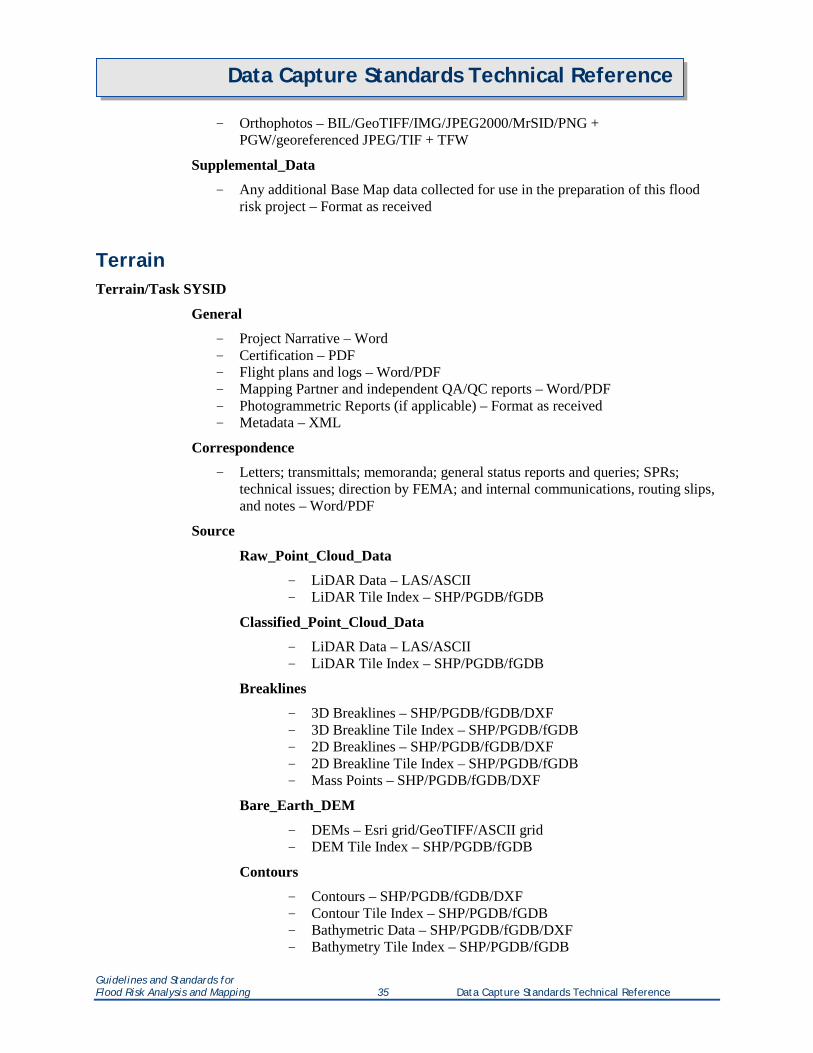
- Orthophotos – BIL/GeoTIFF/IMG/JPEG2000/MrSID/PNG + PGW/georeferenced JPEG/TIF + TFW
Supplemental_Data
- Any additional Base Map data collected for use in the preparation of this flood risk project – Format as received
Terrain Terrain/Task SYSID
General
- Project Narrative – Word - Certification – PDF - Flight plans and logs – Word/PDF - Mapping Partner and independent QA/QC reports – Word/PDF - Photogrammetric Reports (if applicable) – Format as received - Metadata – XML
Correspondence
- Letters; transmittals; memoranda; general status reports and queries; SPRs; technical issues; direction by FEMA; and internal communications, routing slips, and notes – Word/PDF
Source
Raw_Point_Cloud_Data
- LiDAR Data – LAS/ASCII - LiDAR Tile Index – SHP/PGDB/fGDB
Classified_Point_Cloud_Data
- LiDAR Data – LAS/ASCII - LiDAR Tile Index – SHP/PGDB/fGDB
Breaklines
- 3D Breaklines – SHP/PGDB/fGDB/DXF - 3D Breakline Tile Index – SHP/PGDB/fGDB - 2D Breaklines – SHP/PGDB/fGDB/DXF - 2D Breakline Tile Index – SHP/PGDB/fGDB - Mass Points – SHP/PGDB/fGDB/DXF
Bare_Earth_DEM
- DEMs – Esri grid/GeoTIFF/ASCII grid - DEM Tile Index – SHP/PGDB/fGDB
Contours
- Contours – SHP/PGDB/fGDB/DXF - Contour Tile Index – SHP/PGDB/fGDB - Bathymetric Data – SHP/PGDB/fGDB/DXF - Bathymetry Tile Index – SHP/PGDB/fGDB
Guidelines and Standards for Flood Risk Analysis and Mapping 35 Data Capture Standards Technical Reference
Data Capture Standards Technical Reference
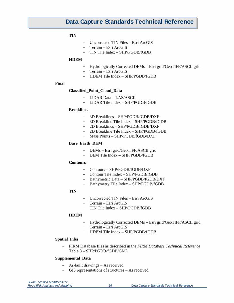
TIN
- Uncorrected TIN Files – Esri ArcGIS - Terrain – Esri ArcGIS - TIN Tile Index – SHP/PGDB/fGDB
HDEM
- Hydrologically Corrected DEMs – Esri grid/GeoTIFF/ASCII grid - Terrain – Esri ArcGIS - HDEM Tile Index – SHP/PGDB/fGDB
Final
Classified_Point_Cloud_Data
- LiDAR Data – LAS/ASCII - LiDAR Tile Index – SHP/PGDB/fGDB
Breaklines
- 3D Breaklines – SHP/PGDB/fGDB/DXF - 3D Breakline Tile Index – SHP/PGDB/fGDB - 2D Breaklines – SHP/PGDB/fGDB/DXF - 2D Breakline Tile Index – SHP/PGDB/fGDB - Mass Points – SHP/PGDB/fGDB/DXF
Bare_Earth_DEM
- DEMs – Esri grid/GeoTIFF/ASCII grid - DEM Tile Index – SHP/PGDB/fGDB
Contours
- Contours – SHP/PGDB/fGDB/DXF - Contour Tile Index – SHP/PGDB/fGDB - Bathymetric Data – SHP/PGDB/fGDB/DXF - Bathymetry Tile Index – SHP/PGDB/fGDB
TIN
- Uncorrected TIN Files – Esri ArcGIS - Terrain – Esri ArcGIS - TIN Tile Index – SHP/PGDB/fGDB
HDEM
- Hydrologically Corrected DEMs – Esri grid/GeoTIFF/ASCII grid - Terrain – Esri ArcGIS - HDEM Tile Index – SHP/PGDB/fGDB
Spatial_Files
- FIRM Database files as described in the FIRM Database Technical Reference Table 3 – SHP/PGDB/fGDB/GML
Supplemental_Data
- As-built drawings – As received - GIS representations of structures – As received
Guidelines and Standards for Flood Risk Analysis and Mapping 36 Data Capture Standards Technical Reference
Data Capture Standards Technical Reference
- Any additional Terrain data collected for use in the preparation of this flood risk project – Format as received
Survey Survey/Task SYSID
HUC-8
General
- Project Narrative – Word - Certification – PDF - Metadata – XML
Correspondence
- Letters; transmittals; memoranda; general status reports and queries; SPRs; technical issues; direction by FEMA; and internal communications, routing slips, and notes – Word/PDF
Photos
- Digital Photographs – JPEG/TIFF/BMP
Sketches
- Digital Sketches – JPEG/TIFF/BMP/PDF
Survey_Data
- Survey Files – MDB/PGDB/fGDB/XLS/XLSX/DBF/ASCII/CSV
Supplemental_Data
- Any additional Survey data collected for use in the preparation of this flood risk project – Format as received
As-Built
- As-Built Data – Format as received
Spatial_Files
- FIRM Database files as described in the FIRM Database Technical Reference Table 3 – SHP/PGDB/fGDB/GML
Hydrology Hydrology/Task SYSID
HUC-8
General
- Hydrology Report – Word and PDF - Draft FIS Section 5.1 – Word and PDF - Project Narrative – Word
Guidelines and Standards for Flood Risk Analysis and Mapping 37 Data Capture Standards Technical Reference
Data Capture Standards Technical Reference
- Certification – PDF - Metadata – XML
Correspondence
- Letters; transmittals; memoranda; general status reports and queries; SPRs; technical issues; direction by FEMA; and internal communications, routing slips, and notes – Word/PDF
Hydrology_Models
Watershed_Name
Simulations
- Model input and output files – Native format - Readme file explaining contents of each named file – TXT
Supplemental_Data
- Database file(s) such as data and analyses for stream and rainfall gages and computations for regional regression equations such as output from USGS PeakFQ, NFF or NSS computer programs – Native format
- Any additional Hydrology data collected for use in the preparation of this flood risk project – Format as received
Spatial_Files
- FIRM Database files as described in the FIRM Database Technical Reference Table 3 – SHP/PGDB/fGDB/GML
Hydraulics Hydraulics/Task SYSID
HUC-8
General
- Hydraulics Report – Word and PDF - Draft FIS Section 5.2 – Word and PDF - Project Narrative – Word - Certification – PDF - Metadata – XML
Correspondence
- Letters; transmittals; memoranda; general status reports and queries; SPRs; technical issues; direction by FEMA; and internal communications, routing slips, and notes – Word/PDF
Hydraulic_Models
Stream_Name (Station)
Simulations
- Model input and output files for all flood frequencies required by the task order and floodway analysis – Native format
Guidelines and Standards for Flood Risk Analysis and Mapping 38 Data Capture Standards Technical Reference
Data Capture Standards Technical Reference
- Model input and output files for levee analysis for the 1-percent-annual-chance flood including, if applicable: de-accredited left levee and hold right levee; de-accredited right levee and hold left levee; both levees in place; and both levees de-accredited (for floodway analysis) – Native format
- Model input and output files for levee analyses for all flood frequencies required by the task order [e.g., the 10-, 4-, 2-(normally with levees in place), 1-, 0.2-(normally without levees) percent-annual-chance floods] – Native format
Profiles
- Profiles – RAS-Plot (MDB)/DXF/DWG
FWDT
- Floodway Data Tables – MDB/XLS/XLSX/DBF - Flood Hazard Data Tables – MDB/XLS/XLSX/DBF
Supplemental_Data
- Database file(s) such as high water mark data for model calibration – Native format
- Zone A backup files – Native format - Any additional Hydraulics data collected for use in the
preparation of this flood risk project – Format as received
Spatial_Files
- FIRM Database files as described in the FIRM Database Technical Reference Table 3 – SHP/PGDB/fGDB/GML
Alluvial Fan AlluvialFan/Task SYSID
HUC-8
General
- Alluvial Fan Technical Report – Word and PDF - Draft FIS Section 5.4 – Word and PDF - Project Narrative – Word - Certification – PDF - Metadata – XML
Correspondence
- Letters; transmittals; memoranda; general status reports and queries; SPRs; technical issues; direction by FEMA; and internal communications, routing slips, and notes – Word/PDF
Hydraulic_Data
Stream_Name
Simulations
Guidelines and Standards for Flood Risk Analysis and Mapping 39 Data Capture Standards Technical Reference
Data Capture Standards Technical Reference
- Model input and output files – Native format
Profiles
- Profiles – RAS-Plot (MDB)/DXF/DWG
Hydraulic_Databases
- Database File(s) – Native format
FAN_Program_Files
Simulations
- Model input and output files – Native format
Supplemental_Data
- Any additional Alluvial Fan data collected for use in the preparation of this flood risk project – Format as received
Spatial_Files
- FIRM Database files as described in the FIRM Database Technical Reference Table 3 – SHP/PGDB/fGDB/GML
Coastal Coastal/Task SYSID
Water_Body_Name
Project_Name
General
- Coastal Analyses and Mapping Reports – Word and PDF - Draft FIS Coastal Hydrology and Coastal Hydraulic Analysis Sections
(typically 5.1 and 5.3) – Word and PDF - FIS Graphics (e.g., SWEL contour map, transect location map) –
PDF/JPEG - FIS Tables – MDB/XLS/XLSX/DBF - FIS Coastal Profiles – PDF/JPEG/DXF/DWG - Project Narrative – Word - Certification – PDF - Metadata – XML
Correspondence
- Letters; transmittals; memoranda; general status reports and queries; SPRs; technical issues; direction by FEMA; and internal communications, routing slips, and notes – Word/PDF
Stillwater_Models
Software_Name
Simulations
Calibration
Guidelines and Standards for Flood Risk Analysis and Mapping 40 Data Capture Standards Technical Reference
Data Capture Standards Technical Reference
- Model input and output files for calibration runs – Native format
Verification
- Model input and output files for verification runs – Native format
Production_Runs
- Model input and output files for production runs including statistical analysis – Native format
Coastal_Databases
- Database file(s) such as high water marks for model calibration – Native format
Supplemental_Data
- Any additional data used in the modeling of this flood risk project – Native format
Model_Name
Spatial_Files
- Spatial files by model – SHP/PGDB/fGDB/GML
Offshore_Wave_Models
Software_Name
Simulations
Calibration
- Model input and output files for calibration runs – Native format
Verification
- Model input and output files for verification runs – Native format
Production_Runs
- Model input and output files for production runs including statistical analysis – Native format
Coastal_Databases
- Database file(s) such as wave buoy data for model calibration – Native format
Supplemental_Data
- Any additional data used in the modeling of this flood risk project – Native format
Model_Name
Spatial_Files
Guidelines and Standards for Flood Risk Analysis and Mapping 41 Data Capture Standards Technical Reference
Data Capture Standards Technical Reference
- Spatial files by model – SHP/PGDB/fGDB/GML
Nearshore_Wave_Models
Software_Name
Simulations
- Model input and output files for WHAFIS 1D wave calculations, runup calculations, or other overland wave models – Native format
- Wave Envelope Files – PDF and DXF or spatially compatible file
Spatial_Files
- Spatial files by model including Transect Layout file –SHP/PGDB/fGDB/GML
Coastal_Databases
- Database file(s) such as CHAMP or WISE – Native format
Supplemental_Data
- Any additional data used in the modeling of this flood risk project – Native format
Transects
- Transects (if one-dimensional model was used) – Native format
Spatial_Files
- FIRM Database files as described in the FIRM Database Technical Reference Table 3 – SHP/PGDB/fGDB/GML
Floodplain Mapping / Redelineation Floodplain/Task SYSID
HUC-8
General
- Draft FIS Report – Word and PDF - FIS Tables – MDB/XLS/XLSX/DBF - FIS text overflow for Principal Flood Problems and Special Considerations (if
necessary) – TXT - Project Narrative – Word - Certification – PDF - Metadata – XML
Correspondence
- Letters; transmittals; memoranda; general status reports and queries; SPRs; technical issues; direction by FEMA; and internal communications, routing slips, and notes – Word/PDF
Guidelines and Standards for Flood Risk Analysis and Mapping 42 Data Capture Standards Technical Reference
Data Capture Standards Technical Reference
Base_Map
- Orthophotos (if not submitted under Base Map) – BIL/GeoTIFF/IMG/JPEG2000/MrSID/PNG + PGW/JPEG/TIF + TFW
Spatial_Files
- FIRM Database files as described in the FIRM Database Technical Reference Table 3 – SHP/PGDB/fGDB/GML
Topographic_Data
- Topographic Data Files (if not submitted under Terrain) – LAS/ASCII/SHP (2D or 3D)/PGDB/fGDB/DXF/Esri Grid/GeoTIFF/ASCII Grid/Esri ArcGIS
Supplemental_Data
- Rectified effective maps and any other data that was used to re-create effective profiles and delineations – Native format
Draft Mapping Data Mapping.Draft_DFIRM_DB/Task SYSID
FIPS
General
- Metadata – XML - FIS text overflow for Principal Flood Problems and Special Considerations (if
necessary) – TXT
Spatial_Files
- FIRM Database files as described in the FIRM Database Technical Reference Table 3 – SHP and PGDB
Preliminary Mapping Data Note that currently the DFIRM Verification Tool (DVT) requires all data used for verification (i.e., SHP files and metadata) to be in the Task SYSID folder.
Mapping.Preliminary_DFIRM_DB/Task SYSID
- Metadata – XML - FIS text overflow for Principal Flood Problems and Special Considerations (if necessary) –
TXT - FIRM Database files as described in the FIRM Database Technical Reference Table 3 – SHP - FIRM Database files as described in the FIRM Database Technical Reference Table 3 –
PGDB
RFIRM
- Preliminary FIRM Panel and Map Index Images – PDF
FIS
- Preliminary FIS Report – PDF
Guidelines and Standards for Flood Risk Analysis and Mapping 43 Data Capture Standards Technical Reference
Data Capture Standards Technical Reference
Final Mapping Data Note that currently the DVT requires all data used for verification (i.e., SHP files and metadata) to be in the Task SYSID folder.
Mapping.Final_DFIRM_DB/Task SYSID
- Metadata – XML - FIS text overflow for Principal Flood Problems and Special Considerations (if necessary) –
TXT - FIRM Database files as described in the FIRM Database Technical Reference Table 3 – SHP - FIRM Database files as described in the FIRM Database Technical Reference Table 3 –
PGDB
RFIRM
- Final georeferenced FIRM Panel and Map Index Images – PNG + PGW/TIF + TFW
Ortho_photos
- Orthoimagery used as base map for FIRMs – BIL/BIP/GeoTIFF/MrSID/PNG + PGW/JPEG/TIF + TFW/ECW
FIS
- Final FIS Report – Word and Bookmarked PDF - Profiles – RAS-Plot (MDB)/DXF/DWG
MSC_Paperwork
- Transmittal Form – Word - Transmittal Letters – Word - Community Map Action List – XLS/XLSX - Inventory Worksheets – XLS/XLSX
MXD
- FIRM Panel and Map Index MXD Files – MXD
FRD_<CaseNumber>
FRD
ArcShape
- FRD as described in the Flood Risk Database Technical Reference – SHP
fGDB
- FRD as described in the Flood Risk Database Technical Reference (note that the depth grids and other rasters are included in the fGDB in addition to being submitted as GeoTIFFs in a separate directory) – fGDB
Metadata
- Metadata – XML
Rasters
Guidelines and Standards for Flood Risk Analysis and Mapping 44 Data Capture Standards Technical Reference
Data Capture Standards Technical Reference
– Depth grids and other rasters – GeoTIFF
FRM
– Flood Risk Map – PDF and MXD
FRR
– Flood Risk Report – PDF and Word
NR_Index
– Non-Regulatory Flood Risk Products Index of communities within the dataset – XLS/XLSX
QA Reports QA/Task SYSID
FIPS
MIP_Reports
- DVT or other MIP reports, MIPHelp emails, etc. – As received
Post Preliminary The Post Preliminary files must be submitted as a .ZIP file for each of the data categories organized in the following directory structure.
LFD/Task SYSID
FIPS
Post_Preliminary
General
- Final Project Narrative – Word - Certification – PDF - Checklists – Word/PDF
Correspondence
- Letters; transmittals; memoranda; general status reports and queries; SPRs; technical issues; direction by FEMA; and internal communications, routing slips, and notes – Word/PDF
FBS
- Preliminary Self-Certification – PDF – Final Self-Certification – PDF
FEDD
– FEDD files (one file per community) – PDF
Non-Regulatory Flood Risk Data There is not yet a pre-defined MIP directory structure for the non-regulatory flood risk data.
Guidelines and Standards for Flood Risk Analysis and Mapping 45 Data Capture Standards Technical Reference
Data Capture Standards Technical Reference
Flood_Risk_Data
HUC-8
General
- Project Narrative – Word - Certification – PDF - Metadata – XML
Correspondence
- Letters; transmittals; memoranda; general status reports and queries; SPRs; technical issues; direction by FEMA; and internal communications, routing slips, and notes – Word/PDF
Flood_Risk_Source_Data
Datasets
CSLF
- Input and output data associated with the Changes Since Last FIRM dataset (not the actual CSLF dataset which is submitted with the FRD) – Native format
FDAG
- Input and output data associated with the Flood Depth and Associated Grids dataset (not the actual grids which are submitted with the FRD) – Native format
FRA
- Input and output data associated with the Flood Risk Assessment dataset, which include Hazus data (not the actual Risk Assessment dataset which is submitted with the FRD) – Native format (.hpr files for Hazus data)
AOMI
- Input and output data associated with the Areas of Mitigation Interest dataset (not the actual AOMI dataset which is submitted with the FRD) – Native format
Products
FRD
- Input and output data associated with the Flood Risk Database (not the actual FRD which is submitted with the final mapping data) – Native format
FRR
- Input and output data associated with the Flood Risk Report (not the actual FRR which is submitted with the FRD) – Native format
FRM
Guidelines and Standards for Flood Risk Analysis and Mapping 46 Data Capture Standards Technical Reference
Data Capture Standards Technical Reference
- Input and output data associated with the Flood Risk Map (not the actual FRM which is submitted with the FRD) – Native format
Supplemental_Data
- Any additional data used to assist in the preparation of this flood risk project – Native format
Guidelines and Standards for Flood Risk Analysis and Mapping 47 Data Capture Standards Technical Reference
Data Capture Standards Technical Reference
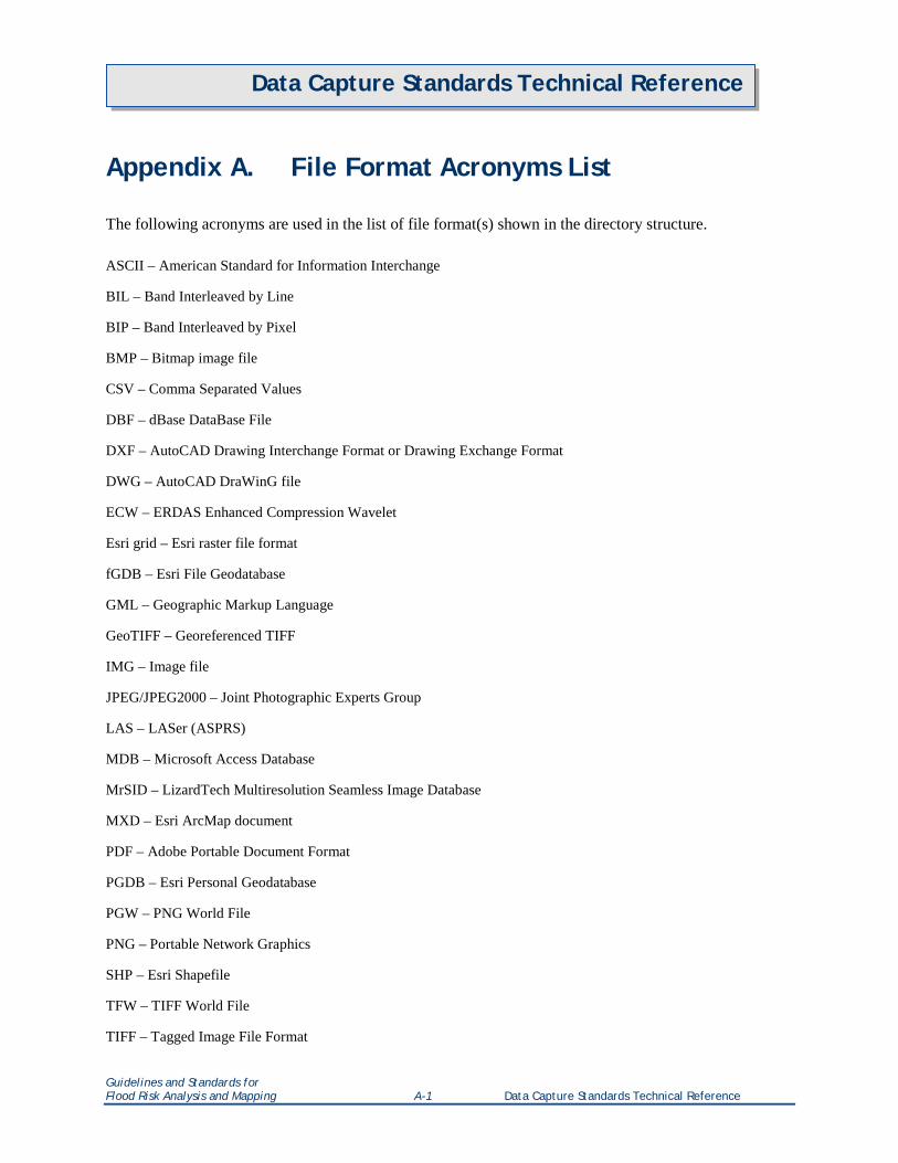
Appendix A. File Format Acronyms List The following acronyms are used in the list of file format(s) shown in the directory structure. ASCII – American Standard for Information Interchange
BIL – Band Interleaved by Line
BIP – Band Interleaved by Pixel
BMP – Bitmap image file
CSV – Comma Separated Values
DBF – dBase DataBase File
DXF – AutoCAD Drawing Interchange Format or Drawing Exchange Format
DWG – AutoCAD DraWinG file
ECW – ERDAS Enhanced Compression Wavelet
Esri grid – Esri raster file format
fGDB – Esri File Geodatabase
GML – Geographic Markup Language
GeoTIFF – Georeferenced TIFF
IMG – Image file
JPEG/JPEG2000 – Joint Photographic Experts Group
LAS – LASer (ASPRS)
MDB – Microsoft Access Database
MrSID – LizardTech Multiresolution Seamless Image Database
MXD – Esri ArcMap document
PDF – Adobe Portable Document Format
PGDB – Esri Personal Geodatabase
PGW – PNG World File
PNG – Portable Network Graphics
SHP – Esri Shapefile
TFW – TIFF World File
TIFF – Tagged Image File Format
Guidelines and Standards for Flood Risk Analysis and Mapping A-1 Data Capture Standards Technical Reference
Data Capture Standards Technical Reference
TIN – Triangulated Irregular Network
TXT – Text file
Word – Microsoft Word .doc or .docx file format
XLS/XLSX – Microsoft Excel format
XML – Extensible Markup Language
Guidelines and Standards for Flood Risk Analysis and Mapping A-2 Data Capture Standards Technical Reference
Data Capture Standards Technical Reference
Appendix B. Transmittal Form TRANSMITTAL FORM
1. Point of Contact: _________________________________ ______________________________ Name of PTS Contractor Name/Title _________________________________ ______________________________ Address Phone Number _________________________________ ______________________________ Email Name of Study / CID _________________________________ Effective Date 2. MSC Deliverables Package: Transmittal Letter(s) LFD Letter Inventory Worksheet CMAL RFIRM (PNG w/PGW) OrthoImagery (w/world files) FIS Report (PDF) Metadata (XML) Shapefiles (SHP w/PRJ) Geodatabase (PGDB)
Guidelines and Standards for Flood Risk Analysis and Mapping A-B-1 Data Capture Standards Technical Reference
Data Capture Standards Technical Reference
Appendix C. Inventory Worksheet
INVENTORY WORKSHEET
TWO COLOR? YES: NO: PTS: STARR
EFFECTIVE DATE: 11/18/2009 PROGRAM STATUS: R
COMMUNITY NUMBER: 470267 MAPPING PARTNER: AMEC
STATE AND COUNTY NUMBER (FIPS): 47145 COUNTY CODE: 145
COMMUNITY NAME: Roane County* STATE/REGION: TN/04
COUNTY NAME: Roane County MSC USE ONLY DATE DIGITAL RECEIVED:
PRINT TYPE NEW: REV:
NEW/REVISED FIRMS STUDY/ FLOODWAYS OBSOLETE
PANEL & SUFFIX QTY TO
TRANSFER PANEL & SUFFIX QTY TO
TRANSFER PANEL & SUFFIX 47145CIND0B 47145CV000B 47145CIND0A 47145C0093G 47145C0093F 47145C0094G 47145C0094F 47145C0113G 47145C0113F 47145C0140G 47145C0140F 47145C0145G 47145C0145F 47145C0160G 47145C0160F 47145C0170G 47145C0170F 47145C0180G 47145C0180F 47145C0185G 47145C0185F 47145C0190G 47145C0190F 47145C0195G 47145C0195F 47145C0205G 47145C0205F 47145C0206G 47145C0206F 47145C0207G 47145C0207F 47145C0210G 47145C0210F 47145C0215G 47145C0215F 47145C0220G 47145C0220F 47145C0226G 47145C0226F
Guidelines and Standards for Flood Risk Analysis and Mapping A-C-1 Data Capture Standards Technical Reference
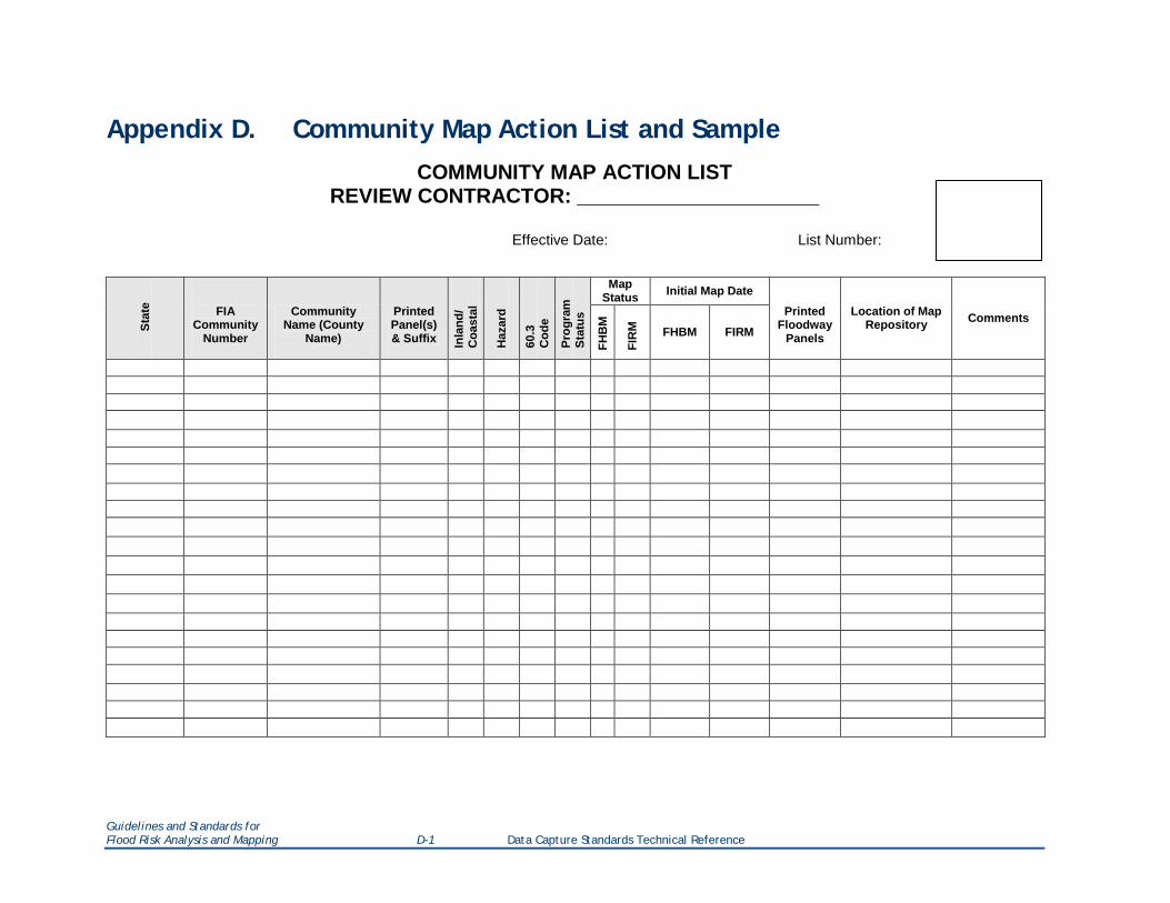
Appendix D. Community Map Action List and Sample COMMUNITY MAP ACTION LIST
REVIEW CONTRACTOR: _____________________
Effective Date: List Number:
Stat
e
FIA Community
Number
Community Name (County
Name)
Printed Panel(s) & Suffix
Inla
nd/
Coa
stal
Haz
ard
60.3
C
ode
Prog
ram
St
atus
Map Status Initial Map Date
Printed Floodway
Panels
Location of Map Repository Comments
FHB
M
FIR
M
FHBM FIRM
Guidelines and Standards for Flood Risk Analysis and Mapping D-1 Data Capture Standards Technical Reference
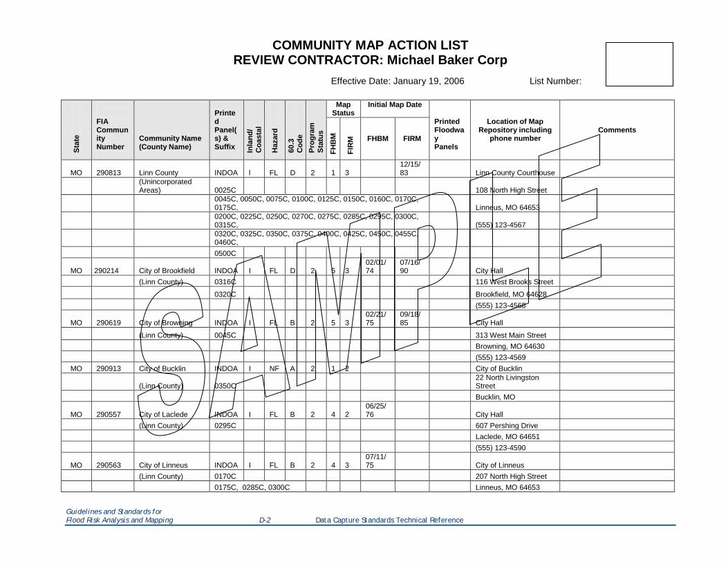
COMMUNITY MAP ACTION LIST REVIEW CONTRACTOR: Michael Baker Corp
Effective Date: January 19, 2006 List Number:
Stat
e
FIA Community Number
Community Name (County Name)
Printed Panel(s) & Suffix In
land
/ C
oast
al
Haz
ard
60.3
C
ode
Prog
ram
St
atus
Map Status
Initial Map Date
Printed Floodway Panels
Location of Map Repository including
phone number Comments
FHB
M
FIR
M FHBM FIRM
MO 290813 Linn County INDOA l FL D 2 1 3 12/15/83 Linn County Courthouse
(Unincorporated Areas) 0025C 108 North High Street
0045C, 0050C, 0075C, 0100C, 0125C, 0150C, 0160C, 0170C, 0175C, Linneus, MO 64653
0200C, 0225C, 0250C, 0270C, 0275C, 0285C, 0295C, 0300C, 0315C, (555) 123-4567
0320C, 0325C, 0350C, 0375C, 0400C, 0425C, 0450C, 0455C, 0460C,
0500C
MO 2 290214 City of Brookfield INDOA I FL D 2 5 3 02/01/74
07/16/90 City Hall
(Linn County) 0316C 116 West Brooks Street
0320C Brookfield, MO 64628 (555) 123-4568
MO 290619 City of Browning INDOA I FL B 2 5 3 02/21/75
09/18/85 City Hall
(Linn County) 0045C 313 West Main Street Browning, MO 64630 (555) 123-4569
MO 290913 City of Bucklin INDOA I NF A 2 1 2 City of Bucklin
(Linn County) 0350C 22 North Livingston Street
Bucklin, MO
MO 290557 City of Laclede INDOA I FL B 2 4 2 06/25/76 City Hall
(Linn County) 0295C 607 Pershing Drive Laclede, MO 64651 (555) 123-4590
MO 290563 City of Linneus INDOA I FL B 2 4 3 07/11/75 City of Linneus
(Linn County) 0170C 207 North High Street 0175C, 0285C, 0300C Linneus, MO 64653
Guidelines and Standards for Flood Risk Analysis and Mapping D-2 Data Capture Standards Technical Reference
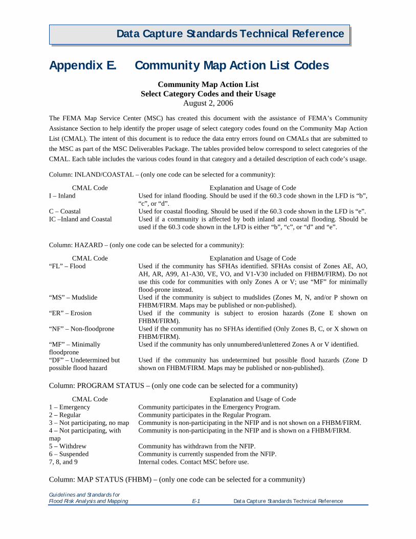
Data Capture Standards Technical Reference
Appendix E. Community Map Action List Codes Community Map Action List
Select Category Codes and their Usage August 2, 2006
The FEMA Map Service Center (MSC) has created this document with the assistance of FEMA’s Community Assistance Section to help identify the proper usage of select category codes found on the Community Map Action List (CMAL). The intent of this document is to reduce the data entry errors found on CMALs that are submitted to the MSC as part of the MSC Deliverables Package. The tables provided below correspond to select categories of the CMAL. Each table includes the various codes found in that category and a detailed description of each code’s usage.
Column: INLAND/COASTAL – (only one code can be selected for a community):
CMAL Code Explanation and Usage of Code I – Inland Used for inland flooding. Should be used if the 60.3 code shown in the LFD is “b”,
“c”, or “d”. C – Coastal Used for coastal flooding. Should be used if the 60.3 code shown in the LFD is “e”. IC –Inland and Coastal Used if a community is affected by both inland and coastal flooding. Should be
used if the 60.3 code shown in the LFD is either “b”, “c”, or “d” and “e”. Column: HAZARD – (only one code can be selected for a community):
CMAL Code Explanation and Usage of Code “FL” – Flood Used if the community has SFHAs identified. SFHAs consist of Zones AE, AO,
AH, AR, A99, A1-A30, VE, VO, and V1-V30 included on FHBM/FIRM). Do not use this code for communities with only Zones A or V; use “MF” for minimally flood-prone instead.
“MS” – Mudslide Used if the community is subject to mudslides (Zones M, N, and/or P shown on FHBM/FIRM. Maps may be published or non-published).
“ER” – Erosion Used if the community is subject to erosion hazards (Zone E shown on FHBM/FIRM).
“NF” – Non-floodprone Used if the community has no SFHAs identified (Only Zones B, C, or X shown on FHBM/FIRM).
“MF” – Minimally floodprone
Used if the community has only unnumbered/unlettered Zones A or V identified.
“DF” – Undetermined but possible flood hazard
Used if the community has undetermined but possible flood hazards (Zone D shown on FHBM/FIRM. Maps may be published or non-published).
Column: PROGRAM STATUS – (only one code can be selected for a community)
CMAL Code Explanation and Usage of Code 1 – Emergency Community participates in the Emergency Program. 2 – Regular Community participates in the Regular Program. 3 – Not participating, no map Community is non-participating in the NFIP and is not shown on a FHBM/FIRM. 4 – Not participating, with map
Community is non-participating in the NFIP and is shown on a FHBM/FIRM.
5 – Withdrew Community has withdrawn from the NFIP. 6 – Suspended Community is currently suspended from the NFIP. 7, 8, and 9 Internal codes. Contact MSC before use. Column: MAP STATUS (FHBM) – (only one code can be selected for a community)
Guidelines and Standards for Flood Risk Analysis and Mapping E-1 Data Capture Standards Technical Reference
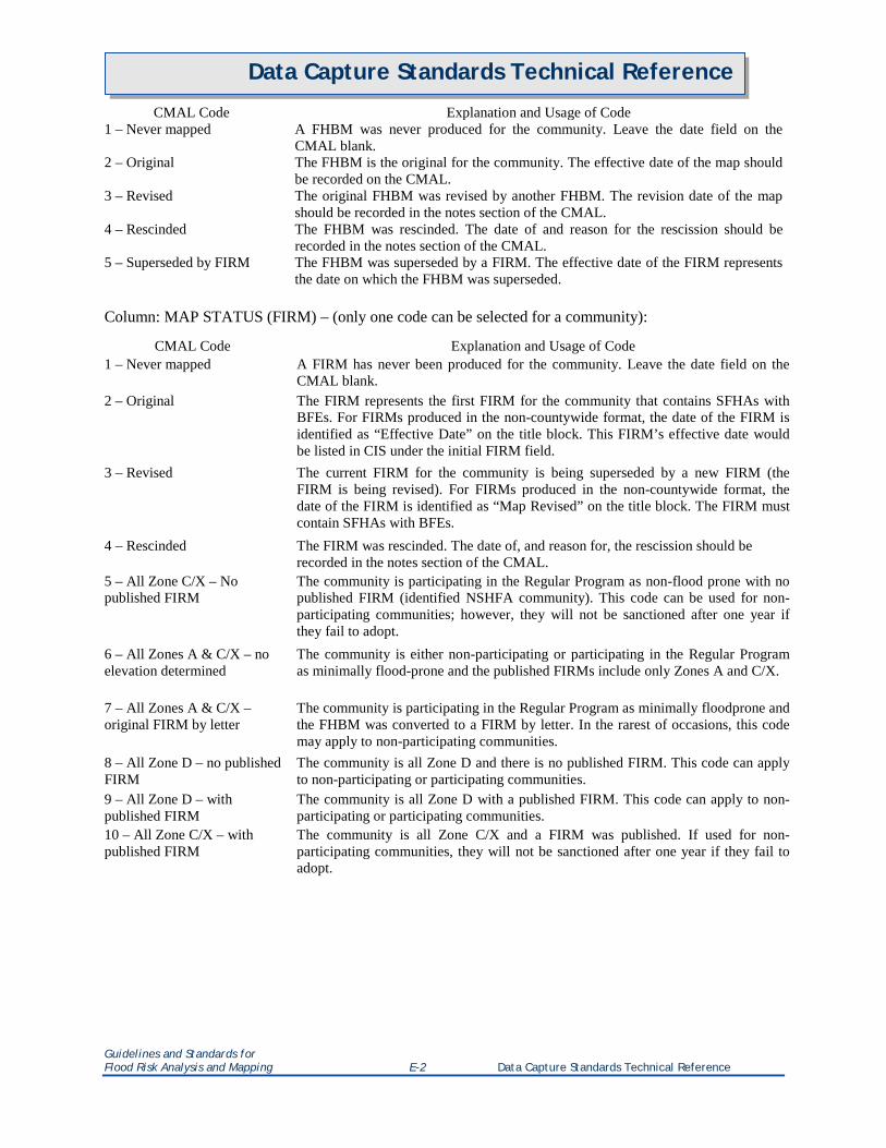
Data Capture Standards Technical Reference
CMAL Code Explanation and Usage of Code 1 – Never mapped A FHBM was never produced for the community. Leave the date field on the
CMAL blank. 2 – Original The FHBM is the original for the community. The effective date of the map should
be recorded on the CMAL. 3 – Revised The original FHBM was revised by another FHBM. The revision date of the map
should be recorded in the notes section of the CMAL. 4 – Rescinded The FHBM was rescinded. The date of and reason for the rescission should be
recorded in the notes section of the CMAL. 5 – Superseded by FIRM The FHBM was superseded by a FIRM. The effective date of the FIRM represents
the date on which the FHBM was superseded. Column: MAP STATUS (FIRM) – (only one code can be selected for a community):
CMAL Code Explanation and Usage of Code 1 – Never mapped A FIRM has never been produced for the community. Leave the date field on the
CMAL blank. 2 – Original The FIRM represents the first FIRM for the community that contains SFHAs with
BFEs. For FIRMs produced in the non-countywide format, the date of the FIRM is identified as “Effective Date” on the title block. This FIRM’s effective date would be listed in CIS under the initial FIRM field.
3 – Revised The current FIRM for the community is being superseded by a new FIRM (the FIRM is being revised). For FIRMs produced in the non-countywide format, the date of the FIRM is identified as “Map Revised” on the title block. The FIRM must contain SFHAs with BFEs.
4 – Rescinded The FIRM was rescinded. The date of, and reason for, the rescission should be recorded in the notes section of the CMAL.
5 – All Zone C/X – No published FIRM
The community is participating in the Regular Program as non-flood prone with no published FIRM (identified NSHFA community). This code can be used for non-participating communities; however, they will not be sanctioned after one year if they fail to adopt.
6 – All Zones A & C/X – no elevation determined
The community is either non-participating or participating in the Regular Program as minimally flood-prone and the published FIRMs include only Zones A and C/X.
7 – All Zones A & C/X – original FIRM by letter
The community is participating in the Regular Program as minimally floodprone and the FHBM was converted to a FIRM by letter. In the rarest of occasions, this code may apply to non-participating communities.
8 – All Zone D – no published FIRM
The community is all Zone D and there is no published FIRM. This code can apply to non-participating or participating communities.
9 – All Zone D – with published FIRM
The community is all Zone D with a published FIRM. This code can apply to non-participating or participating communities.
10 – All Zone C/X – with published FIRM
The community is all Zone C/X and a FIRM was published. If used for non-participating communities, they will not be sanctioned after one year if they fail to adopt.
Guidelines and Standards for Flood Risk Analysis and Mapping E-2 Data Capture Standards Technical Reference

Data Capture Standards Technical Reference
Appendix F. Flood Risk Products Index Form A sample Flood Risk Products Index form is shown below. All Regions, states, counties, CIDs, and products associated with the Flood Risk Products submission should be listed.
Flood Risk Products Index
Case Number 12-04-1235S Region 4
State GA
AL
FRR FRR_12-04-1235S_20130606.pdf
FRM FRM_12-04-1235S_20130606.pdf
FRD FRD_12-04-1235S_20130606.gdb
GeoTiffs Depth_01pct.gtiff
Depth_02pct.gtiff
Depth_04pct.gtiff
Depth_10pct.gtiff
Depth_0_2pct.gtiff
Depth_01plus.gtiff
WSE_01pct.gtiff
WSE_02pct.gtiff
WSE_04pct.gtiff
WSE_10pct.gtiff
WSE_0_2pct.gtiff
County 13456
12456
CIDs 12345C
123456
123455
123466
124893
124897
Guidelines and Standards for Flood Risk Analysis and Mapping F-1 Data Capture Standards Technical Reference