Embed Size (px)
Citation preview
Data Models
Chapter 8 - Vegetation Inventory Standards and Data Model Documents
Resource Information Management Branch Alberta Sustainable Resource Development


Resource Information Management Branch, Alberta Sustainable Resource Development
Data Models • iii
Table of Contents
1. AVI DATA MODEL ......................................................................................................................... 1 UPDATES....................................................................................................................................................3
1.1 INTRODUCTION TO CHAPTER 8 SECTION 1....................................................... 5 1.2 AVI LOGICAL DATA MODEL ................................................................................. 5
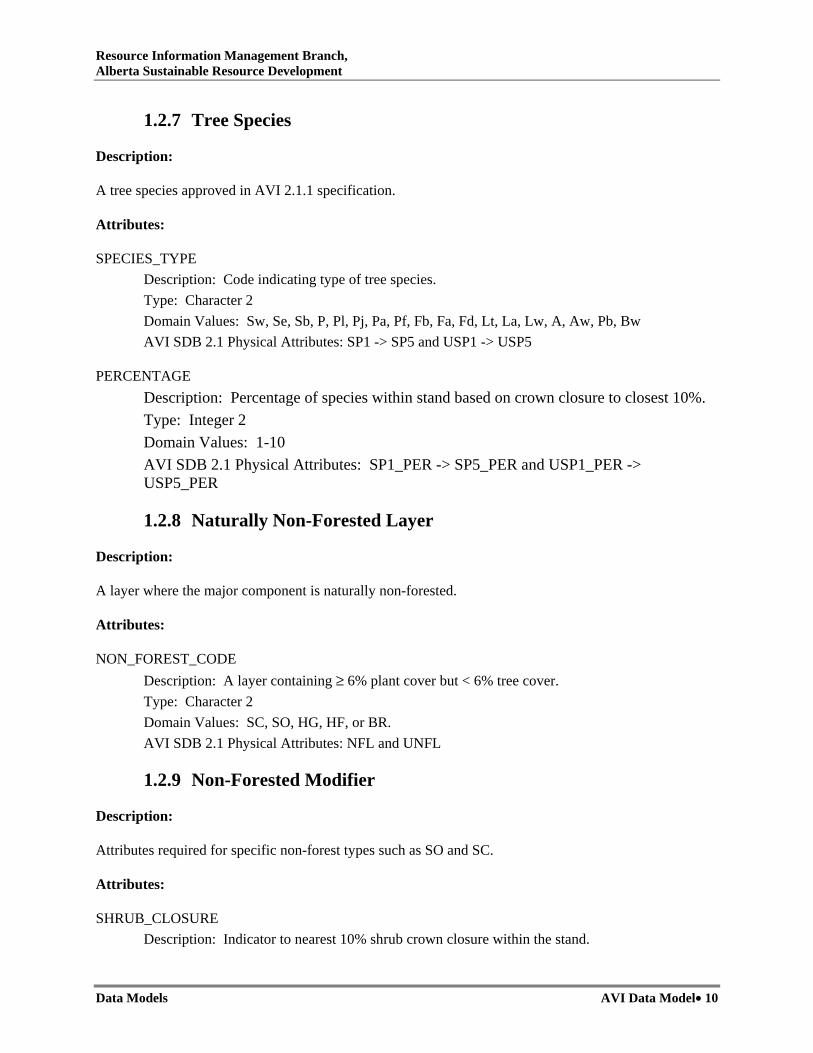
1.2.1 Interpreter..................................................................................................................... 5 1.2.2 Existing Data Reference ............................................................................................... 7 1.2.3 Forest Stand.................................................................................................................. 7 1.2.4 Layer............................................................................................................................. 8 1.2.5 Layer Site...................................................................................................................... 8 1.2.6 Forested Layer.............................................................................................................. 9 1.2.7 Tree Species................................................................................................................ 10 1.2.8 Naturally Non-Forested Layer ................................................................................... 10 1.2.9 Non-Forested Modifier ............................................................................................... 10 1.2.10 Anthropogenic Vegetated Layer .............................................................................. 11 1.2.11 Naturally Non-Vegetated Layer............................................................................... 11 1.2.12 Anthropogenic Non-Vegetated Layer ...................................................................... 11 1.2.13 Stand Modifier ......................................................................................................... 12
1.3 AVI SDB 2.1 PHYSICAL MODEL........................................................................... 13 1.4 PHYSICAL TO LOGICAL CROSS REFERENCE .................................................. 15 1.5 VALID FIELD DOMAIN VALUES ......................................................................... 17 1.6 AVI FILE FORMAT DESCRIPTION....................................................................... 18
2. DEPLETION UPDATE DATA MODEL ..................................................................................... 23 3. CONIFER UNDERSTOREY DETECTION DATA MODEL ................................................... 25 UPDATES..................................................................................................................................................27
3.1 INTRODUCTION TO CHAPTER 8 SECTION 3..................................................... 29 3.2 LOGICAL DATA MODEL ....................................................................................... 29
3.2.1 Interpreter................................................................................................................... 29 3.2.2 Existing Data Reference ............................................................................................. 31 3.2.3 Forest Stand................................................................................................................ 31 3.2.4 Forested Layer............................................................................................................ 32 3.2.5 Tree Species................................................................................................................ 33
3.3 PHYSICAL DATA MODEL ..................................................................................... 34 3.4 PHYSICAL TO LOGICAL CROSS REFERENCE .................................................. 36 3.5 VALID FIELD DOMAIN VALUES ......................................................................... 37 3.6 AVI FILE FORMAT DESCRIPTION....................................................................... 38
List of Tables
Table 1-1: AVI Physical to Logical cross reference. ................................................................................. 15 Table 1-2. AVI File Format Description – PAT File. ................................................................................ 18

Resource Information Management Branch, Alberta Sustainable Resource Development
Data Models • iv
Table 1-3. AVI Attribute Table – ATT File............................................................................................... 18 Table 3-1. Cross-reference of conifer understorey detection physical fields to their logical equivalents. . 36 Table 3-2. Conifer understorey detection inventory fields and valid domain values.................................. 37 Table 3-3. Conifer understorey detection polygon attribute table (.PAT). ................................................ 38 Table 3-4. Conifer understorey detection attribute table (.ATT). .............................................................. 39
List of Figures
Figure 1-1 AVI Logical Model . .................................................................................................................. 6 Figure 1-2 AVI Physical Model. ............................................................................................................... 14 Figure 3-1. Conifer understorey detection Logical Data Model with key attribute relationships............... 30 Figure 3-2. Conifer understorey detection Physical Data Model with key attribute relationships. ............ 35

Resource Information Management Branch, Alberta Sustainable Resource Development
Data Models AVI Data Model• 1
1. AVI Data Model
Version 2.1 March 2006

Resource Information Management Branch, Alberta Sustainable Resource Development
Data Models AVI Data Model• 2

Resource Information Management Branch, Alberta Sustainable Resource Development
Data Models AVI Data Model• 3
UPDATES
AVI Data Model, Version 2.1., March 2006 was incorporated into the Alberta Vegetation Inventory Standards and Data Model Documents (as part of Chapter 8) in June 2006. Subsequent revisions to the document are summarized below:
Date Type of Revision Version No. Sections Revised
None to date

Resource Information Management Branch, Alberta Sustainable Resource Development
Data Models AVI Data Model• 4

Resource Information Management Branch, Alberta Sustainable Resource Development
Data Models AVI Data Model• 5
1.1 Introduction to Chapter 8 Section 1 The following document “AVI Data Model” forms a component of “Chapter 8 – Vegetation Inventory Standards and Data Model Documents”. The document details the Alberta Vegetation Inventory (AVI) digital format currently used within ASRD. “AVI Data Model” is designed for use with AVI Version 2.1.1 and should be used in conjunction with “Alberta Vegetation Inventory Interpretation Standards, Version 2.1.1 (Chapter 3 – Vegetation Inventory Standards and Data Model Documents).
1.2 AVI Logical Data Model The AVI Logical Data Model (Figure 1-1) is intended to provide an overview of AVI entities/pseudo-entities and the relationships that exist between them in context of the business rules outlined in the first section of this document. The entity definition and relationships with other entities are governed by the business rules established for them. For example when an Anthropogenic Vegetated Layer contains CPR then business rules dictate that a Naturally Non-Vegetated Code of SO or SC must also exist. This results in a relationship connection between these two entities as indicated in the physical implementation of the AVI SDB specification. Because of certain exceptions dictated by business rules, some leeway for the purpose of simplification was taken when defining some entities. For example Layer Site has been related to the supertype Layer since it exists either optionally or by requirement in the majority of subtype Layers. This relationship, however, violates the rule that MOISTURE_REGIME and TPR cannot be found in association with the Anthropogenic Non-Vegetated Layer subtype. Where these types of exceptions exist, notes have been added to describe the situation.
1.2.1 Interpreter
Description:
Information about the name of the person that interpreted and assigned the polygon attributes.
Attributes:
INTERPRETER_INITIALS Description: Initials of person that interpreted the polygon Type: Character 2 Domain Values: Any alphanumeric characters. AVI SDB 2.1 Physical Attributes: INITIALS and UINITIALS

Resource Information Management Branch, Alberta Sustainable Resource Development
Data Models AVI Data Model• 6
Figure 1-1 AVI Logical Model .
CROWN_CLOSUREORIGINSTAND_HEIGHT
Forested Layer
NON_FOREST_CODE
NaturallyNon-Forested Layer
ANTH_VEG_CODE
AnthropogenicVegetated Layer
ANTH_NON_VEG_CODE
Anth Non-VegetatedLayer
NAT_NON_VEG_CODE
NaturallyNon-Vegetated Layer
SPECIES_TYPEPERCENTAGE
Tree Species
Contains
Is A
Is A
Is A
Contains
Is A
MODIFIER_CODEMODIFIER_EXTENTMODIFIER_YEAR
Stand Modifier
Modified ByModified By
Modified By
EXISTING_DATA_CODEEXISTING_DATA_YEAR
Existing Data Reference
Verified By
INTERPRETER_INITIALS
Interpreter
Interpreted By
Modified By
Can Exist With
Edit Date: 7/14/98 4:23:35 AM
Description:AVI 2.1 Logical Entity Relationships
Target DB: INFO Rev: 1.0 Creator:
Filename: Drawing1 Company:GISmo Solutions Ltd.
AVI
STAND_IDAREAPERIMETER
Forst Stand
LAYER_TYPELAYER_MODIFIER
Layer
Is A
MOISTURE_REGIMETPR
Layer Site
Qualified By
SHRUB_CLOSURESHRUB_HEIGHT
Non-Forested Modifier
Modified By

Resource Information Management Branch, Alberta Sustainable Resource Development
Data Models AVI Data Model• 7
1.2.2 Existing Data Reference
Description:
Data gathered from other existing sources to verify or aid in the interpretation of the polygon label.
If more than one set of attributes (EXISTING-DATA-CODE and EXISTING-DATA-YEAR) exists for a polygon, the following hierarchy applies: 1 Interpreter field plot (F), 2 Air call (A), 3 Interpreted TPR (I), 4 Supplementary photography (S), 5 PSP (P), 6 Cruise data (C), 7 Volume plot (V), 8 Large- scale photography (L).
Attributes:
EXISTING_DATA_CODE Description: Code indicating external source used. Type: Character 1 Domain Values: F, A, I, S, P, C, V, L AVI SDB 2.1 Physical Attributes: DATA and UDATA
EXISTING_DATA_YEAR Description: Year associated with external data source. Type: Integer 4 Domain Values: 1940 – current year of inventory AVI SDB 2.1 Physical Attributes: DATA_YR and UDATA_YR
1.2.3 Forest Stand
Description:
An area containing a distinct combination of tree species, possessing uniformity in composition, age, arrangement or condition that can be uniquely delineated on aerial photography.
Attributes:
STAND_ID Description: Uniquely generated ID. Type: Integer 10 Domain Values: 1 – 2147483646 AVI SDB 2.1 Physical Attributes: COV-ID and POLY_NUM

Resource Information Management Branch, Alberta Sustainable Resource Development
Data Models AVI Data Model• 8
AREA Description: Area of polygon in square metres. Type: Real Domain Values: ≥ Min Stand Size AVI SDB 2.1 Physical Attributes:
PERIMETER Description: Perimeter of polygon in metres. Type: Real Domain Values: > 0 AVI SDB 2.1 Physical Attributes:
1.2.4 Layer
Description:
A classification of the stand according to a distinct vertical or horizontal stratification that divides the stands into unique components.
Attributes:
LAYER_TYPE Description: Class of stand layer. Type: Character 1 Domain Values: Blank, C, H, M AVI SDB 2.1 Physical Attributes: STRUC and USTRUC
LAYER_MODIFIER Description: Percentage area of stand covered by Horizontal layer, or difference between the midpoint of upper layer to midpoint of lower layer for complex stands. Type: Integer 1 Domain Values: 1 to 9 AVI SDB 2.1 Physical Attributes: STRUC_VAL and USTRUC_VAL
1.2.5 Layer Site
Description:
Distinct attribute information that is gathered for the majority of layer types.
Attributes:
MOISTURE_REGIME Description: A general description of the moisture quality of layer. Type: Character 1

Resource Information Management Branch, Alberta Sustainable Resource Development
Data Models AVI Data Model• 9
Domain Values: d, m, w, or a AVI SDB 2.1 Physical Attributes: MOIST_REG and UMOIST_REG
TPR Description: Potential timber productivity of a stand based on height and age of dominant and co-dominant trees of the leading species. Type: Character 1 Domain Values: G, M, F, or U AVI SDB 2.1 Physical Attributes: TPR and UTPR
1.2.6 Forested Layer
Description:
A layer is considered forested if it supports tree growth (including seedlings and saplings) with a crown closure of > 6%.
Attributes:
CROWN_CLOSURE Description: Percentage of ground area covered by a vertical projection of the tree crowns to the ground. Type: Character 1 Domain Values: A, B, C, or D AVI SDB 2.1 Physical Attributes: DENSITY and UDENSITY
ORIGIN Description: Year of stand origin. Type: Integer 4 Domain Values: 1400 – current year AVI SDB 2.1 Physical Attributes: ORIGIN and UORIGIN
STAND_HEIGHT Description: Average height of the dominant and co-dominant trees of the leading species in meters. Type: Integer 2 Domain Values: 1 – 40 AVI SDB 2.1 Physical Attributes: HEIGHT and UHEIGHT
Resource Information Management Branch, Alberta Sustainable Resource Development
Data Models AVI Data Model• 10
1.2.7 Tree Species
Description:
A tree species approved in AVI 2.1.1 specification.
Attributes:
SPECIES_TYPE Description: Code indicating type of tree species. Type: Character 2 Domain Values: Sw, Se, Sb, P, Pl, Pj, Pa, Pf, Fb, Fa, Fd, Lt, La, Lw, A, Aw, Pb, Bw AVI SDB 2.1 Physical Attributes: SP1 -> SP5 and USP1 -> USP5
PERCENTAGE Description: Percentage of species within stand based on crown closure to closest 10%. Type: Integer 2 Domain Values: 1-10 AVI SDB 2.1 Physical Attributes: SP1_PER -> SP5_PER and USP1_PER -> USP5_PER
1.2.8 Naturally Non-Forested Layer
Description:
A layer where the major component is naturally non-forested.
Attributes:
NON_FOREST_CODE Description: A layer containing ≥ 6% plant cover but < 6% tree cover. Type: Character 2 Domain Values: SC, SO, HG, HF, or BR. AVI SDB 2.1 Physical Attributes: NFL and UNFL
1.2.9 Non-Forested Modifier
Description:
Attributes required for specific non-forest types such as SO and SC.
Attributes:
SHRUB_CLOSURE Description: Indicator to nearest 10% shrub crown closure within the stand.

Resource Information Management Branch, Alberta Sustainable Resource Development
Data Models AVI Data Model• 11
Type: Integer 2 Domain Values: 1-10 AVI SDB 2.1 Physical Attributes: NFL_PER and UNFL_PER
SHRUB_HEIGHT Description: Average height of shrubs in meters. Type: Integer 2 Domain Values: 1-6 AVI SDB 2.1 Physical Attributes: HEIGHT and UHEIGHT
1.2.10 Anthropogenic Vegetated Layer
Description:
Vegetated land where the vegetation has been influenced by man, usually in areas that have been planted with cultivated species.
Attributes:
ANTH_VEG_CODE Description: Code indicating type of anthropogenic activity. Type: Character 3 Domain Values: CA, CP, CPR, CIP, or CIW. AVI SDB 2.1 Physical Attributes: ANTH_VEG and UANTH_VEG
1.2.11 Naturally Non-Vegetated Layer
Description:
Natural cover types that have < 6% plant cover.
Attributes:
NAT_NON_VEG_CODE Description: Code indicating non-vegetated type. Type: Character 3 Domain Values: NWI, NWL, NWR, NWF, NMB, NMC, NMR, or NMS. AVI SDB 2.1 Physical Attributes: NAT_NON and UNAT_NON
1.2.12 Anthropogenic Non-Vegetated Layer
Description:
A layer where the major component is influenced by man and plant cover is < 6%

Resource Information Management Branch, Alberta Sustainable Resource Development
Data Models AVI Data Model• 12
Attributes:
ANTH_NON_VEG_CODE Description: Code indicating anthropogenic non-vegetated type. Type: Character 3 Domain Values: ASC, ASR, AIH, AIE, AIG, AIF, AIM, or AII. AVI SDB 2.1 Physical Attributes: ANTH_NON and UANTH_NON
1.2.13 Stand Modifier
Description:
A condition or treatment providing additional information about the origin or condition of the cover type.
Attributes:
MODIFER_CODE Description: Code related to condition or treatment Type: Character 2 Domain Values: CC, BU, WF, CL, DI, IK, UK, WE, DT, BT, SN, ST, SI, SC, PL, TH, GR, IR. AVI SDB 2.1 Physical Attributes: MOD1, MOD2, UMOD1, UMOD2
MODIFIER_EXTENT Description: Percentage based indication of what portion of stand (by crown closure or land area affected) is affected by the condition or treatment. Type: Integer 1 Domain Values: 1 to 5 AVI SDB 2.1 Physical Attributes: MOD1_EXT, MOD2_EXT, UMOD1_EXT, and UMOD2_EXT
MODIFIER_YEAR Description: Year that condition or treatment took place where known. Type: Integer 4 Domain Values: 1900 - current year AVI SDB 2.1 Physical Attributes: MOD1_YR, MOD2_YR, UMOD1_YR, and UMOD2_YR

Resource Information Management Branch, Alberta Sustainable Resource Development
Data Models AVI Data Model• 13
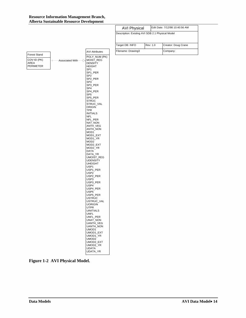
1.3 AVI SDB 2.1 Physical Model The Entity Relationship Diagram in Figure 1-2 represents the current physical implementation of the AVI SDB 2.1 specification. The physical model differs significantly from the logical model with the incorporation of almost the entire logical model into a single physical attribute table.
Many of the relationships indicated in the logical model are implied in the physical model through the existence or absence of particular key fields. For example if the Species 1 field contains data then we can imply that the layer is forested and only those fields associated with a forested layer can be populated. For the most part this key definition schema works, but breaks down when you run into situations where more than one key field contains data. Without some form of discriminator field that distinctly indicates the intended layer type there is no way of clearly determining the intended layer when multiple key fields are populated. This complicates the validation process somewhat where multiple fields must be queried in order to get some idea of what the intended layer type is so that appropriate validation rules can be applied. It can also complicates some types of user queries, rather then query a single discriminatory field the user must query multiple key fields to refine their query according to layer type.
The other problem with using a single table is the amount of wasted space when only a single layer exists or there are no modifiers associated with a layer. In the majority of cases only a single layer is associated with an AVI stand. This means you are carrying an entire blank record in these situations. On a township basis this is not significant, but it is when you build a data repository for the entire province. In some situations where applications must process both layers of data the empty understorey records may have significant impact on the performance of the process.
While incorporating the entire model into a single table complicates some situations, and results in wasted space it makes the distribution and maintenance of data easier. Processes that extract subsets of data are more efficient since they only have work with a single physical table. In many cases it is also easier for end users to utilize the data since they do not have to be concerned with any complicated relate and join operations when using the data.
Resource Information Management Branch, Alberta Sustainable Resource Development
Data Models AVI Data Model• 14
Figure 1-2 AVI Physical Model.
COV-ID (PK)AREAPERIMETER
Forest StandPOLY_NUM (PK)MOIST_REGDENSITYHEIGHTSP1SP1_PERSP2SP2_PERSP3SP3_PERSP4SP4_PERSP5SP5_PERSTRUCSTRUC_VALORIGINTPRINITIALSNFLNFL_PERNAT_NONANTH_VEGANTH_NONMOD1MOD1_EXTMOD1_YRMOD2MOD2_EXTMOD2_YRDATADATA_YRUMOIST_REGUDENSITYUHEIGHTUSP1USP1_PERUSP2USP2_PERUSP3USP3_PERUSP4USP4_PERUSP5USP5_PERUSTRUCUSTRUC_VALUORIGINUTPRUINITIALSUNFLUNFL_PERUNAT_NONUANTH_VEGUANTH_NONUMOD1UMOD1_EXTUMOD1_YRUMOD2UMOD2_EXTUMOD2_YRUDATAUDATA_YR
AVI Attributes
Associated With
Edit Date: 7/12/98 10:40:56 AM
Description: Existing AVI SDB 2.1 Physical Model
Target DB: INFO Rev: 1.0 Creator: Doug Crane
Filename: Drawing3 Company:
AVI Physical
Resource Information Management Branch, Alberta Sustainable Resource Development
Data Models AVI Data Model• 15
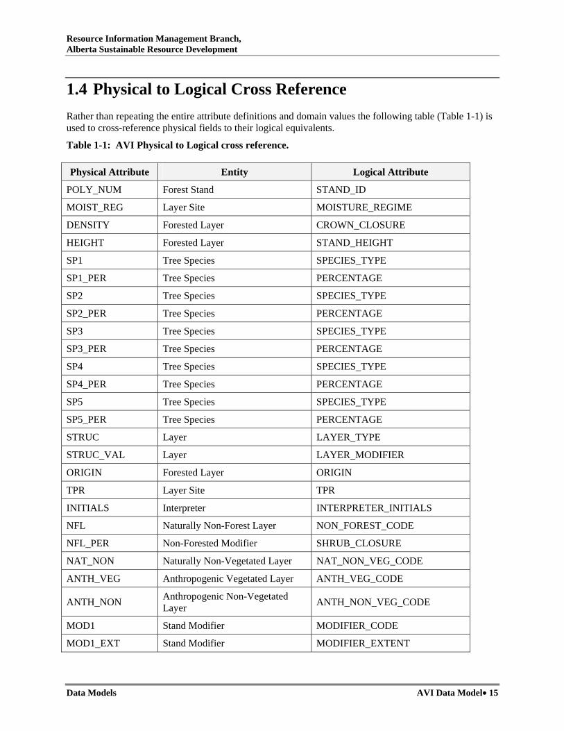
1.4 Physical to Logical Cross Reference Rather than repeating the entire attribute definitions and domain values the following table (Table 1-1) is used to cross-reference physical fields to their logical equivalents.
Table 1-1: AVI Physical to Logical cross reference.
Physical Attribute Entity Logical Attribute
POLY_NUM Forest Stand STAND_ID
MOIST_REG Layer Site MOISTURE_REGIME
DENSITY Forested Layer CROWN_CLOSURE
HEIGHT Forested Layer STAND_HEIGHT
SP1 Tree Species SPECIES_TYPE
SP1_PER Tree Species PERCENTAGE
SP2 Tree Species SPECIES_TYPE
SP2_PER Tree Species PERCENTAGE
SP3 Tree Species SPECIES_TYPE
SP3_PER Tree Species PERCENTAGE
SP4 Tree Species SPECIES_TYPE
SP4_PER Tree Species PERCENTAGE
SP5 Tree Species SPECIES_TYPE
SP5_PER Tree Species PERCENTAGE
STRUC Layer LAYER_TYPE
STRUC_VAL Layer LAYER_MODIFIER
ORIGIN Forested Layer ORIGIN
TPR Layer Site TPR
INITIALS Interpreter INTERPRETER_INITIALS
NFL Naturally Non-Forest Layer NON_FOREST_CODE
NFL_PER Non-Forested Modifier SHRUB_CLOSURE
NAT_NON Naturally Non-Vegetated Layer NAT_NON_VEG_CODE
ANTH_VEG Anthropogenic Vegetated Layer ANTH_VEG_CODE
ANTH_NON Anthropogenic Non-Vegetated Layer ANTH_NON_VEG_CODE
MOD1 Stand Modifier MODIFIER_CODE
MOD1_EXT Stand Modifier MODIFIER_EXTENT

Resource Information Management Branch, Alberta Sustainable Resource Development
Data Models AVI Data Model• 16
Table 1-1. continued. Physical Attribute Entity Logical Attribute
MOD1_YR Stand Modifier MODIFIER_YEAR
MOD2 Stand Modifier MODIFIER_CODE
MOD2_EXT Stand Modifier MODIFIER_EXTENT
MOD2_YR Stand Modifier MODIFIER_YEAR
DATA Existing Data Reference EXISTING_DATA_CODE
DATA_YR Existing Data Reference EXISTING_DATE_YEAR
UMOIST_REG Layer Site MOISTURE_REGIME
UDENSITY Forested Layer CROWN_CLOSURE
UHEIGHT Forested Layer STAND_HEIGHT
USP1 Tree Species SPECIES_TYPE
USP1_PER Tree Species PERCENTAGE
USP2 Tree Species SPECIES_TYPE
USP2_PER Tree Species PERCENTAGE
USP3 Tree Species SPECIES_TYPE
USP3_PER Tree Species PERCENTAGE
USP4 Tree Species SPECIES_TYPE
USP4_PER Tree Species PERCENTAGE
USP5 Tree Species SPECIES_TYPE
USP5_PER Tree Species PERCENTAGE
USTRUC Layer LAYER_TYPE
USTRUC_VAL Layer LAYER_MODIFIER
UORIGIN Forested Layer ORIGIN
UTPR Layer Site TPR
UINITIALS Interpreter INTERPRETER_INITIALS
UNFL Naturally Non-Forest Layer NON_FOREST_CODE
UNFL_PER Non-Forested Modifier SHRUB_CLOSURE
UNAT_NON Naturally Non-Vegetated Layer NAT_NON_VEG_CODE
UANTH_VEG Anthropogenic Vegetated Layer ANTH_VEG_CODE
UANTH_NON Anthropogenic Non-Vegetated Layer ANTH_NON_VEG_CODE
UMOD1 Stand Modifier MODIFIER_CODE
UMOD1_EXT Stand Modifier MODIFIER_EXTENT
Resource Information Management Branch, Alberta Sustainable Resource Development
Data Models AVI Data Model• 17
Table 1-1. continued. Physical Attribute Entity Logical Attribute
UMOD1_YR Stand Modifier MODIFIER_YEAR
UMOD2 Stand Modifier MODIFIER_CODE
UMOD2_EXT Stand Modifier MODIFIER_EXTENT
UMOD2_YR Stand Modifier MODIFIER_YEAR
UDATA Existing Data Reference EXISTING_DATA_CODE
UDATA_YR Existing Data Reference EXISTING_DATE_YEAR
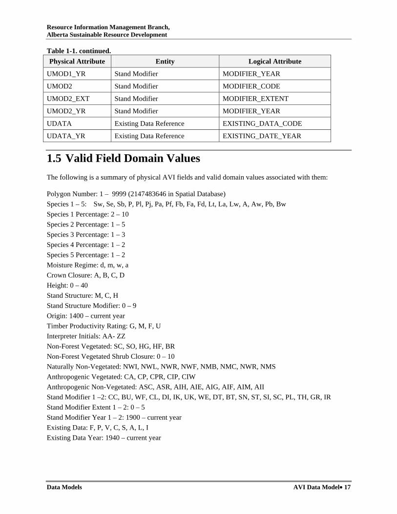
1.5 Valid Field Domain Values The following is a summary of physical AVI fields and valid domain values associated with them:
Polygon Number: 1 – 9999 (2147483646 in Spatial Database) Species 1 – 5: Sw, Se, Sb, P, Pl, Pj, Pa, Pf, Fb, Fa, Fd, Lt, La, Lw, A, Aw, Pb, Bw Species 1 Percentage: 2 – 10 Species 2 Percentage: 1 – 5 Species 3 Percentage: 1 – 3 Species 4 Percentage: 1 – 2 Species 5 Percentage: 1 – 2 Moisture Regime: d, m, w, a Crown Closure: A, B, C, D Height: 0 – 40 Stand Structure: M, C, H Stand Structure Modifier: 0 – 9 Origin: 1400 – current year Timber Productivity Rating: G, M, F, U Interpreter Initials: AA- ZZ Non-Forest Vegetated: SC, SO, HG, HF, BR Non-Forest Vegetated Shrub Closure: 0 – 10 Naturally Non-Vegetated: NWI, NWL, NWR, NWF, NMB, NMC, NWR, NMS Anthropogenic Vegetated: CA, CP, CPR, CIP, CIW Anthropogenic Non-Vegetated: ASC, ASR, AIH, AIE, AIG, AIF, AIM, AII Stand Modifier 1 –2: CC, BU, WF, CL, DI, IK, UK, WE, DT, BT, SN, ST, SI, SC, PL, TH, GR, IR Stand Modifier Extent 1 – 2: 0 – 5 Stand Modifier Year 1 – 2: 1900 – current year Existing Data: F, P, V, C, S, A, L, I Existing Data Year: 1940 – current year

Resource Information Management Branch, Alberta Sustainable Resource Development
Data Models AVI Data Model• 18
1.6 AVI File Format Description AVI file format descriptions for .PAT and .ATT files are provided in Table 1-2 and Table 1-3, respectively.
Table 1-2. AVI File Format Description – PAT File.
.PAT File
Field Name
Data Type Width No. Decimals
Description
Area Floating point 18 5 Area in m2
Perimeter Floating point 18 5 Perimeter in m2
Binary 5 0 Internal ArcInfo identifier
- id Binary 5 0 ArcInfo id number
ID Numeric 10 0 Polygon number (key field to link to spatial (.att) file)
Forestkey Numeric 10 0 Polygon number (key field to link to spatial (.att) file)
Poly_num Numeric 10 0 Polygon number (key field to link to spatial (.att) file)
Table 1-3. AVI Attribute Table – ATT File.
.ATT File
Field Name Data Type Width No. Decimals Description
Poly_num Numeric 10 0 Polygon number (key field to link to spatial (.pat) file). May also appear as FORESTKEY or ID.
Moist_reg Character 1
Moisture regime: d = dry m = mesic w = wet a = aquatic
Density Character 1
Crown closure (%): A = 6 to 30 % B = 31 to 50 % C = 51 to 70 % D = 70 % +
Height Numeric 2 0 Average stand height (dominant & codominant trees) in meters.
Sp1, Sp2, Sp3, Sp4, Sp5
Character 2 Declining order of species based on crown closure Sw, Se, Sb, P, Pl, Pj, Pa, Pf, Fb, Fa, Fd, Lt, La, Lw, A, Aw, Pb, Bw
Sp1_per to Sp5_per Numeric 2 0 Actual % (to nearest 10) of species listed above.

Resource Information Management Branch, Alberta Sustainable Resource Development
Data Models AVI Data Model• 19
Table 1-3. continued.
.ATT File
Field Name Data Type Width No. Decimals Description
Struc Character
Stand structure: Blank = inferred single storey M = multi-layer canopy (2 storey) C = complex (multiple or uneven stories) H = Horizontal (homogeneous stand with scattered pockets)
Struc_val Numeric 2 0 Used only with 'H' above (e.g., 80% Pl, 20% Aw pockets would be Pl8 / Aw2 (based on crown closure composition)
Origin Numeric 4 0 Actual year of origin
Tpr Character 1
Tree productivity rating (site index grouping) U = Unproductive F = Fair M = Medium G = Good
Initials Character 2 AVI interpreters initials
Nfl Character 2
Non-forest vegetated land (>6% plant cover and <6% tree cover):
SC = closed shrub SO = open shrub HG = herbaceous grassland HF = herbaceous forbs BR = bryophyte (moss)
Nfl_per Numeric 2 0 Nfl % closure, SC or SO only
Nat_non Character 3
Naturally non-vegetated (<6% plant cover): NWI = Permanent ice/snow NWL = Seasonal thaws, lakes, ponds NWR = River NWF = Flooded NMB = Recent burn NMC = Cutbank NMR = Rock/barren NMS = Sand

Resource Information Management Branch, Alberta Sustainable Resource Development
Data Models AVI Data Model• 20
Table 1-3 continued
.ATT File
Field Name Data Type Width No. Decimals Description
Anth_veg Character 3
Human-induced vegetation: A = Annual crops (farmland) CP = Perennial forage crops CPR = Rough pasture (>10% woody cover) CIP = Pipelines, powerlines etc. seeded to grass CIW = Geophysical and wellsites seeded to grass
Anth_non Character 3
Anthropogenic non-vegetated land: ASC = Cities, towns, villages, hamlets ASR = Ribbon development, subdivisions, acreages AIH = Permanent right-of-way AIE = Peat extractions AIG = Gravel/borrow pits AIF = Farmyards AIM = Surface mines AII = Industrial sites, sewage lagoons
Mod1, Mod2 Character 2
Stand modifier 1 (or 2) condition/treatment: CC = Clearcut, partial cut BU = Burn WF = Windfall CL = Clearing DI = Disease IK = Insect kill UK = Unknown kill WE = Weather (eg.,. redbelt) DT = Discolored/dead tops BT = Broken tops SN = snags ST = Scattered timber SI = Site improvement (fertilization, draining) SC = Seedbed prepared PL = Planted/seeded TH = Thinned GR = Grazing development (domestic) IR = Irrigated

Resource Information Management Branch, Alberta Sustainable Resource Development
Data Models AVI Data Model• 21
Table 1-3 continued
.ATT File
Field Name Data Type Width No. Decimals Description
Mod1_ext, Mod2_ext Numeric 2 0
Modifier extent: Blank = nil 1 = 1 to 25% loss of crown closure or area affected 2 = 26 to 50% 3 = 51 to 75% 4 = 76 to 94% 5 = Entire
Mod1_yr, Mod2_yr Numeric 4 0 Year of the stand modifying occurrence
Data
Character
1
Data Source F = Interpreter plot P = PSP V = Volume plot C = cruise data S = supplementary photography A = air call L = large-scale photography I = interpreted TPR
Data_yr Numeric 4 0 Year of the data source
Umoist_r Character 1 Understorey moisture regime
Udensity Character 1 Understorey density
Uheight Numeric 2 0 Understorey height
Usp1, Usp2, Usp3, Usp4, Usp5
Character 2 Understorey species composition
Usp1_per to Usp5_per Numeric 2 0 Understorey species percent
Ustruc Character 1 Understorey stand structure
Ustruc_v Numeric 2 0 Understorey stand structure value
Uorigin Numeric 4 0 Understorey origin
Utpr Character 1 Understorey TPR
Uinitial Character 2 Understorey interpreter’s initials
Unfl Character 2 Understorey non-forest vegetated land
Resource Information Management Branch, Alberta Sustainable Resource Development
Data Models AVI Data Model• 22
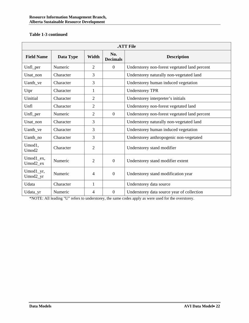
Table 1-3 continued
.ATT File
Field Name Data Type Width No. Decimals Description
Unfl_per Numeric 2 0 Understorey non-forest vegetated land percent
Unat_non Character 3 Understorey naturally non-vegetated land
Uanth_ve Character 3 Understorey human induced vegetation
Utpr Character 1 Understorey TPR
Uinitial Character 2 Understorey interpreter’s initials
Unfl Character 2 Understorey non-forest vegetated land
Unfl_per Numeric 2 0 Understorey non-forest vegetated land percent
Unat_non Character 3 Understorey naturally non-vegetated land
Uanth_ve Character 3 Understorey human induced vegetation
Uanth_no Character 3 Understorey anthropogenic non-vegetated
Umod1, Umod2 Character 2 Understorey stand modifier
Umod1_ex, Umod2_ex Numeric 2 0 Understorey stand modifier extent
Umod1_yr, Umod2_yr Numeric 4 0 Understorey stand modification year
Udata Character 1 Understorey data source
Udata_yr Numeric 4 0 Understorey data source year of collection *NOTE: All leading "U" refers to understorey, the same codes apply as were used for the overstorey.

Resource Information Management Branch, Alberta Sustainable Resource Development
Data Models Depletion Update Data Model• 23
2. Depletion Update Data Model
Not available

Resource Information Management Branch, Alberta Sustainable Resource Development
Data Models Depletion Update Data Model• 24

Resource Information Branch Alberta Sustainable Resource Development
Data Models Conifer Understorey Detection Data Model• 25
3. Conifer Understorey Detection Data Model
Version 1.0 December 2004

Resource Information Branch Alberta Sustainable Resource Development
Data Models Conifer Understorey Detection Data Model• 26

Resource Information Branch Alberta Sustainable Resource Development
Data Models Conifer Understorey Detection Data Model• 27
UPDATES
“Conifer Understorey Detection Data Model” December 2004 was incorporated into the Alberta Vegetation Inventory Standards and Data Model Documents (as part of Chapter 8) in June 2006. Subsequent revisions to the document are summarized below:
Date Type of Revision Version No. Sections Revised
None to date

Resource Information Branch Alberta Sustainable Resource Development
Data Models Conifer Understorey Detection Data Model• 28

Resource Information Branch Alberta Sustainable Resource Development
Data Models Conifer Understorey Detection Data Model• 29
3.1 Introduction to Chapter 8 Section 3 The following document forms part of Chapter 8 of Alberta’s Vegetation Inventory Standards and Data Model Documents.
“Conifer Understorey Detection Data Model” describes the data model accepted by Alberta Sustainable Resource Development for use in conjunction with the understorey enhancement standard.
The interpretation standards for the conifer understorey inventory are described in “Detection of Coniferous Understorey Under Deciduous Dominant Stands” (part of Chapter 6 – Vegetation Inventory Standards and Data Model Documents). Understorey inventory is conducted in conjunction with, or as an addition to, Alberta Vegetation Inventory (see “Alberta Vegetation Inventory Standards” (Chapter 3 – Vegetation Inventory Standards and Data Model Documents)).
3.2 Logical Data Model The logical data model for conifer understorey enhancement (see Figure 3-1) provides an overview of entities and pseudo-entities, and the relationships that exist between them. The entity definitions and the relationships between the various entities are governed by business and validation rules. For example, the existence of some entities may require further conformance to a set of rules that govern associations with other entities in the model. The validation criteria and business rules that govern these relationships have not been described in this data model. Currently this model does not retain linkages to source AVI data.
3.2.1 Interpreter
Description:
Information about the person who did the interpretation and assigned the polygon attributes.
Attributes:
INTERPRETER_INITIALS Description: Initials of person that interpreted the polygon Type: Character 2 Domain Values: Any alphanumeric characters. Physical Attributes: CU_INITIALS

Resource Information Branch Alberta Sustainable Resource Development
Data Models Conifer Understorey Detection Data Model• 30
SPECIES_TYPEPERCENTAGE
Tree Species
Contains
Is A
EXISTING_DATA_CODEEXISTING_DATA_YEAR
Existing Data Reference
Verified By
INTERPRETER_INITIALS
Interpreter
Interpreted By
Edit Date: 04/02/20 3:42:14 PM
Description:AVI Conifer Understory Logical Data Model
Target DB: INFO Rev: 1.0 Creator: AVI Unit
Filename: AVI Conifer UnderstoreyLogical Data Model.vsd
Company:Resource Data Branch
AVI CU LOGICAL
STAND_IDAREAPERIMETER
Forest Stand
CROWN_CLOSURESTAND_HEIGHTSTAND_HEIGHT_MINSTAND_HEIGHT_MAXORIGINORIGIN_MINORIGIN_MAXCONIFER_STEMSCANOPY_PATTERN
Forested Layer
ATTRIBUTE - Primary Key
ATTRIBUTE - Composite KeyATTRIBUTE
- Entity
Relationship - Relationship Type & Cardinality
Figure 3-1. Conifer understorey detection Logical Data Model with key attribute relationships.

Resource Information Branch Alberta Sustainable Resource Development
Data Models Conifer Understorey Detection Data Model• 31
3.2.2 Existing Data Reference
Description:
Data gathered from other existing sources that aid in the interpretation of the coniferous understorey. If more than one set of attributes (EXISTING-DATA-CODE and EXISTING-DATA-YEAR) exists for a polygon, the following hierarchy applies: 1. Interpreter field plot (F), 2. Air call (A), 3. Interpreted TPR (I), 4. Supplementary photography (S), 5. PSP (P), 6. Cruise data (C), 7. Volume plot (V), 8. Large-scale photography (L).
Attributes:
EXISTING_DATA_CODE Description: Code indicating external source used. Type: Character 1 Domain Values: F, A, I, S, P, C, V, L Physical Attributes: CU_DATA
EXISTING_DATA_YEAR Description: Year associated with external data source. Type: Integer 4 Domain Values: 1940 – current year (suggested years 1940 and current year of inventory) Physical Attributes: CU_DATA_YR
3.2.3 Forest Stand
Description:
A community of trees possessing sufficient uniformity in composition, age, arrangement or condition to be distinguishable from the forest or other growth on adjoining areas, thus forming a silvicultural or management entity.
Attributes:
STAND_ID Description: Uniquely generated ID. Type: Integer 10 Domain Values: 1 – 2147483646 Physical Attributes: COV-ID and CU_POLY_NUM

Resource Information Branch Alberta Sustainable Resource Development
Data Models Conifer Understorey Detection Data Model• 32
AREA Description: Area of polygon in square metres. Type: Real Domain Values: > Min Stand Size Physical Attributes: AREA
PERIMETER Description: Perimeter of polygon in metres. Type: Real Domain Values: > 0 Physical Attributes: PERIMETER
3.2.4 Forested Layer
Description:
Coniferous understoreys may be single storied or complex. Single-storey understoreys have > 80% of the understorey trees within a 3 m range along their modal tree height. Complex structures occur when no clearly defined understorey layer is present and heights of > 20% of the understorey trees exceed a 3 m range in height. Trees to be considered in the coniferous understorey have a height range of greater than or equal to 2 m and 3 m less that the AVI overstorey height.
Attributes:
CROWN_CLOSURE Description: The ground area within a treed polygon, expressed as the percentage of the total polygon area, covered by a vertical projection of the tree crowns onto the ground. Type: Character 1 Domain Values: A, B, C, or D Physical Attributes: CU_DENSITY
STAND_HEIGHT Description: Modal height of the coniferous trees in the layer. Type: Integer 2 Domain Values: 1 – 37 Physical Attributes: CU_HEIGHT
STAND_HEIGHT_MIN Description: Minimum height of the coniferous trees in the layer. Type: Integer 2 Domain Values: 1 – 37 Physical Attributes: CU_HEIGHT_MN

Resource Information Branch Alberta Sustainable Resource Development
Data Models Conifer Understorey Detection Data Model• 33
STAND_HEIGHT_MAX Description: Maximum height of the coniferous trees in the layer. Type: Integer 2 Domain Values: 1 – 37 Physical Attributes: CU_HEIGHT_MX
ORIGIN Description: Year of stand origin. Type: Integer 4 Domain Values: 1400 – current year Physical Attributes: CU_ORIGIN
ORIGIN_MIN Description: Lower limit of origin variation. Type: Integer 4 Domain Values: 1400 – current year Physical Attributes: CU_ORIGIN_MN
ORIGIN_MAX Description: Upper limit of origin variation. Type: Integer 4 Domain Values: 1400 – current year Physical Attributes: CU_ORIGIN_MX
CONIFER_STEMS Description: Visual estimation of the number of coniferous stems per hectare expressed in density classes. Type: Integer 1 Domain Values: 1 - 7 Physical Attributes: CU_STEMS
CANOPY_PATTERN Description: Canopy pattern. Type: Integer 1 Domain Values: 1 – 6 Physical Attributes: CU_PATTERNC
3.2.5 Tree Species
Description:
A tree species approved in AVI 2.1.1 specification.
Resource Information Branch Alberta Sustainable Resource Development
Data Models Conifer Understorey Detection Data Model• 34
Attributes:
SPECIES_TYPE Description: Code indicating type of tree species. Type: Character 2 Domain Values: Fb, Fa, Fd, F, Pl, Pj, P, Sb, Se, Sw, S, U Physical Attributes: CU_SP1 -> CU_SP5
SPECIES COMPOSITION in PERCENT Description: Percentage each tree species (5 maximum) occupies within an understorey layer based on crown closure recorded to the closest 10%. Type: Integer 2 Domain Values: 1-10 Physical Attributes: CU_SP1_PER -> CU_SP5_PER
3.3 Physical Data Model The Entity Relationship Diagram in Figure 3-2 represents the physical implementation of the “Inventory Enhancement of Conifer Species Under Deciduous Dominant Stand – Interpretation Standard”. The physical model differs significantly from the logical model in that almost the entire logical model is incorporated into a single physical attribute table. The physical model facilitates use in conjunction with the AVI 2.1 physical data model (Section 1.3).
Note that many of the relationships indicated in the logical model are implied in the physical model through the existence or absence of particular key fields. For example, if the Minimum Stand Height field contains data then we can imply that the understorey layer is complex.
Tables describing the ESRI ArcInfo coverage format structure for implementing the physical data model are provided in Appendix I.

Resource Information Branch Alberta Sustainable Resource Development
Data Models Conifer Understorey Detection Data Model• 35
COV-IDAREAPERIMETER
Forest Stand Associated With
Edit Date: 04/02/20 4:16:57 PM
Description:AVI Conifer Understorey Physical Data Model
Target DB: INFO Rev: 1.0 Creator: AVI Unit
Filename: AVI Conifer UnderstoreyPhysical Data Model.vsd
Company: Resource DataBranch
AVI CU Physical
CU_POLY_NUMCU_DENSITYCU_HEIGHTCU_HEIGHT_MNCU_HEIGHT_MXCU_SP1CU_SP1_PERCU_SP2CU_SP2_PERCU_SP3CU_SP3_PERCU_SP4CU_SP4_PERCU_SP5CU_SP5_PERCU_ORIGINCU_ORIGIN_MNCU_ORIGIN_MXCU_INITIALSCU_DATACU_DATA_YRCU_STEMSCU_PATTERNC
AVI Attributes
ATTRIBUTE - Primary Key
ATTRIBUTE - Composite KeyATTRIBUTE
- Entity
Relationship - Relationship Type & Cardinality
Figure 3-2. Conifer understorey detection Physical Data Model with key attribute relationships.
Resource Information Branch Alberta Sustainable Resource Development
Data Models Conifer Understorey Detection Data Model• 36
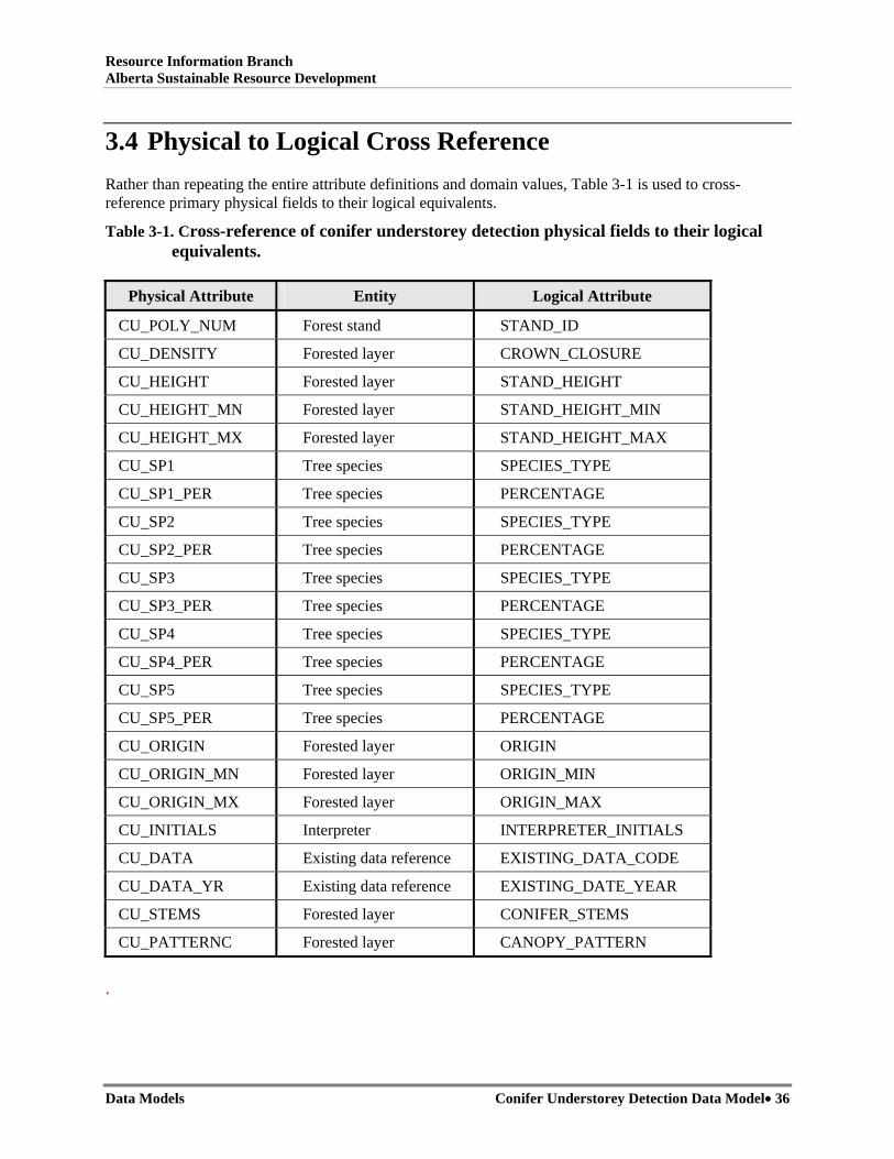
3.4 Physical to Logical Cross Reference Rather than repeating the entire attribute definitions and domain values, Table 3-1 is used to cross-reference primary physical fields to their logical equivalents.
Table 3-1. Cross-reference of conifer understorey detection physical fields to their logical equivalents.
Physical Attribute Entity Logical Attribute
CU_POLY_NUM Forest stand STAND_ID
CU_DENSITY Forested layer CROWN_CLOSURE
CU_HEIGHT Forested layer STAND_HEIGHT
CU_HEIGHT_MN Forested layer STAND_HEIGHT_MIN
CU_HEIGHT_MX Forested layer STAND_HEIGHT_MAX
CU_SP1 Tree species SPECIES_TYPE
CU_SP1_PER Tree species PERCENTAGE
CU_SP2 Tree species SPECIES_TYPE
CU_SP2_PER Tree species PERCENTAGE
CU_SP3 Tree species SPECIES_TYPE
CU_SP3_PER Tree species PERCENTAGE
CU_SP4 Tree species SPECIES_TYPE
CU_SP4_PER Tree species PERCENTAGE
CU_SP5 Tree species SPECIES_TYPE
CU_SP5_PER Tree species PERCENTAGE
CU_ORIGIN Forested layer ORIGIN
CU_ORIGIN_MN Forested layer ORIGIN_MIN
CU_ORIGIN_MX Forested layer ORIGIN_MAX
CU_INITIALS Interpreter INTERPRETER_INITIALS
CU_DATA Existing data reference EXISTING_DATA_CODE
CU_DATA_YR Existing data reference EXISTING_DATE_YEAR
CU_STEMS Forested layer CONIFER_STEMS
CU_PATTERNC Forested layer CANOPY_PATTERN
.

Resource Information Branch Alberta Sustainable Resource Development
Data Models Conifer Understorey Detection Data Model• 37
3.5 Valid Field Domain Values Table 3-2 provides a summary of physical conifer understorey inventory fields and valid domain values associated with them.
Table 3-2. Conifer understorey detection inventory fields and valid domain values.
Physical Model Fields Valid Domain Values
Polygon number 1 – 9999 (2147483646 in Spatial Repository)
Crown closure A, B, C, D
Stand height 2 – 37
Stand height min 2 – 37
Stand height max 2 – 37
Species 1 – 5 Sw, Se, Sb, Pl, Pj, Fb, Fa, Fd, S, P, F, U
Species 1 percentage 2 – 10
Species 2 percentage 1 – 5
Species 3 percentage 1 – 3
Species 4 percentage 1 – 2
Species 5 percentage 1 – 2
Origin 1400 – current year
Origin min 1400 – current year
Origin max 1400 – current year
Interpreter initials AA- ZZ
Existing data F, P, V, C, S, A, L, I
Existing data year 1940 – current year
Conifer stems 1 – 7
Canopy pattern 1 – 6

Resource Information Branch Alberta Sustainable Resource Development
Data Models Conifer Understorey Detection Data Model• 38
3.6 AVI File Format Description AVI file format descriptions for .PAT and .ATT files are provided in Table 3-3 and Table 3-4, respectively.
Table 3-3. Conifer understorey detection polygon attribute table (.PAT).
Field Name Data Type Width Dec. Description
Area Floating Point 18 5 Area in squared metres
Perimeter Floating Point 18 5 Perimeter in metres
# Binary 5 ArcInfo internal record number
-id Binary 5 ArcInfo internal id number
Cu_Poly_num Integer 10 Polygon number (Primary Key)

Resource Information Branch Alberta Sustainable Resource Development
Data Models Conifer Understorey Detection Data Model• 39
Table 3-4. Conifer understorey detection attribute table (.ATT).
Field Name Data Type Width Dec. Description
CU_Poly_num Integer 10 Polygon number (Primary Key)
CU_Density Character 1 Crown Closure (%) A = 6 to 30% B = 31 to 50% C = 51 to 70% D = 70 % +
CU_Height Integer 2 Modal understorey stand height (metres)
CU_Height_mn Integer 2 Min understorey stand height (metres)
CU_Height_mx Integer 2 Max understorey stand height (metres)
CU_Sp1 – CU_Sp5
Character 2 Declining order of species based on abundance in forest canopy - Sw, Se, Sb, Pl, Pj, Fb, Fa, Fd, S, P, F, U
CU_Sp1_per – CU_Sp5_per
Integer 2 Actual % (to nearest 10) of species
CU_Origin Integer 4 Actual year of stand origin
CU_Origin_mn Integer 4 Lower limit of origin variation
CU_Origin_mx Integer 4 Upper limit of origin variation
CU_Initials Character 2 AVI interpreters initials
CU_Data Character 1 Data source F = Interpreter plot P = PSP V = Volume plot C = Cruise data S = Supplementary photography A = Air call L = Large-scale photography I = Interpreted TPR
CU_Data_yr Integer 4 Year of the data source
CU_Stems Integer 1 Density of coniferous stems per hectare
CU_Patternc Integer 1 Canopy pattern class

Resource Information Branch Alberta Sustainable Resource Development
Data Models Version 2.1 • 40
For additional information, please contact: Resource Information Management Branch, Alberta Sustainable Resource Development Edmonton, AB
http://www.srd.gov.ab.ca/index.html


![Conifer expansion [Chapter M.] - fs.fed.us](https://img.pdfslide.net/doc/110x75/61cace1c98ffe14ced450e01/conifer-expansion-chapter-m-fsfedus.jpg)