Embed Size (px)
Citation preview

Data quality from a
producer’s perspective
Dolors Barrot & Maria Pla

Contents
Context
Quality information
Collected data
Examples
Management
Improving the Usability of Geospatial Data, 14th June 2017, Ordnance Survey, Southampton, UK
2

Context
Institut Cartogràfic i Geològic de Catalunya (ICGC)
Catalan Geoinformation Agency and reference public service for the
application of geo-scientific knowledge (Government of Catalonia).
Aim: Deliver to users valued geographic and geological information
and services . [free]
Creation: 2014
Merger of 2 Orgs.: ICC (1982) + IGC (2005)
Employees: 274 (April 2017)
Location: Barcelona, Tremp
Institutional and commercial activities
Multidisciplinary knowledge fields
Geodesy, Geomatics, Cartography, SDI, Geology, Geophysics
Improving the Usability of Geospatial Data, 14th June 2017, Ordnance Survey, Southampton, UK
3

Context
Vector data
Topographic databases
1: 25000 (ISO 2009)
1: 5000 (ISO 2006)
1: 1000
4
Improving the Usability of Geospatial Data, 14th June 2017, Ordnance Survey, Southampton, UK
4
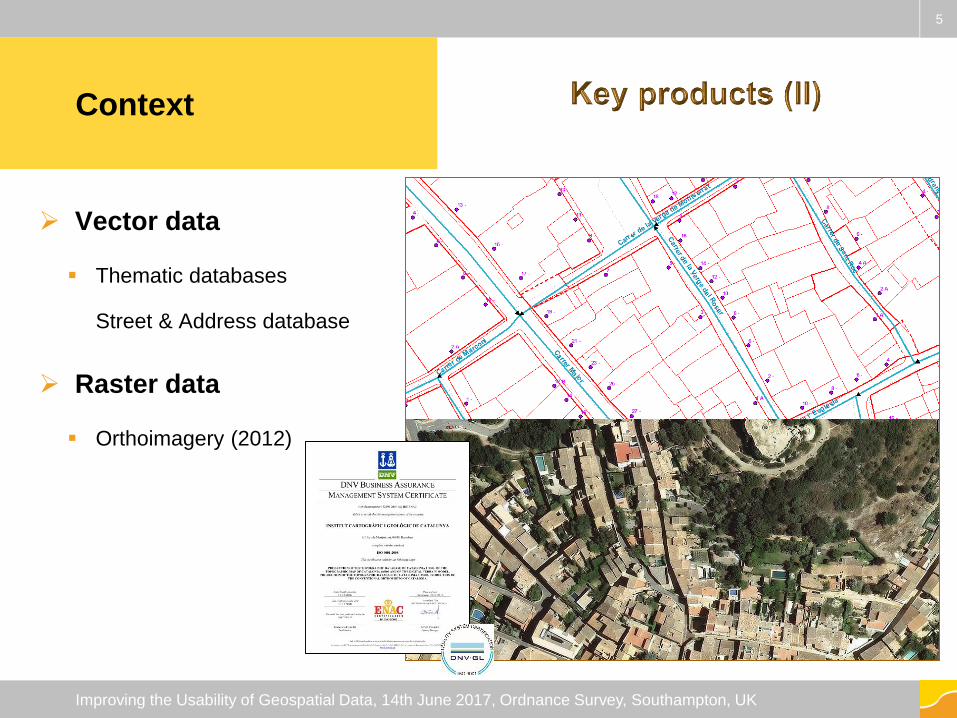
Context
Vector data
Thematic databases
Street & Address database
Raster data
Orthoimagery (2012)
5
Improving the Usability of Geospatial Data, 14th June 2017, Ordnance Survey, Southampton, UK
5

Quality information
Information collected to have a better knowledge of
Management
Data productProductionprocess
Distribution services
Users’ feedback
Improving the Usability of Geospatial Data, 14th June 2017, Ordnance Survey, Southampton, UK
66

Data product
Topographic database (I)
Control by design : 0 errors
Domain consistency
Full control on feature catalogue: feature classes, authorized attribute combination, attributes domain,
geometries, …
Conceptual consistency
Data capture with tools designed to ensure the minimum sizes and minimum distances between elements
Semi-automatic controls to warranty the logical consistency rules
Topological and conceptual consistency: false positives and, occasionally some error
Full control of topological rules and altimetry consistency between elements
A registry is created for each false positives and error
Improving the Usability of Geospatial Data, 14th June 2017, Ordnance Survey, Southampton, UK
77

Improving the Usability of Geospatial Data, 14th June 2017, Ordnance Survey, Southampton, UK
88

Improving the Usability of Geospatial Data, 14th June 2017, Ordnance Survey, Southampton, UK
99
Path connection
Plot border continuity

Data product
Topographic database (II)
Manual control: Visual inspection by sampling
Completeness and thematic accuracy
Around the 40% of the data is inspected in order to mark omissions, commissions and
misinterpretations. The correction of errors is decided taking into account the error
importance, the degree of complexity of the area, and the available resources.
The sample varies depending on the zone characteristics and the experience of the
operator.
Manual control: positional check
Horizontal and vertical accuracy:
Annually, a set of points coming from the field points database is measured in the updated
topographic data and a new global RMS is calculated.
Improving the Usability of Geospatial Data, 14th June 2017, Ordnance Survey, Southampton, UK
1010

Improving the Usability of Geospatial Data, 14th June 2017, Ordnance Survey, Southampton, UK
Examples
1111

Data product
Topographic data
Quality Sampling By
design
Semi-
automatic
controls
Manual
controls
Non
conformities
Completeness 40% X Yes
Logical
consistency100% X X No
Positional
accuracyX Yes
Thematic
accuracy40% X Yes
Temporal quality X No
Improving the Usability of Geospatial Data, 14th June 2017, Ordnance Survey, Southampton, UK
1212

Management
Internally
Refinement of production specifications
More accurate descriptions reducing ambiguities,
Harmonization criteria
Procedures refinement
Development of tools increasing the robustness of procedures
Operators’ training
Externally
Quality chapter in the data product specifications with measures and
conformance level.
Tests results reported in metadata
Improving the Usability of Geospatial Data, 14th June 2017, Ordnance Survey, Southampton, UK
1313

Data product
Thematic database (Street & Address database)
Control by design : 0 errors
Domain consistency
Full control on feature catalogue: feature classes, authorized attribute combination,
attributes domain, geometries, …
Semi-automatic controls to warranty the logical consistency rules
Topological and conceptual consistency: false positives and some errors
Full control of topological and conceptual rules: connectivity, consistency of street names.
A registry is created for each false positives and errors.
Completeness by comparison with other sources
Full control against the Street catalogue of National Institute of Statistics
Some municipalities against the Municipal Census Population…)
Improving the Usability of Geospatial Data, 14th June 2017, Ordnance Survey, Southampton, UK
14

Examples
15
Improving the Usability of Geospatial Data, 14th June 2017, Ordnance Survey, Southampton, UK

Management
Improving the Usability of Geospatial Data, 14th June 2017, Ordnance Survey, Southampton, UK
1616
Metadata fileQuality chapter of the specifications

Data product
Orthoimages (I)
Semi-automatic controls to warranty the logical consistency rules
Radiometric rules: radiometric continuity, spectral quality (dynamic range, saturation)
Geometric rules: geometric continuity, pixel size, coverage
Semi-automatic and manual controls to check positional accuracy
By correlation of orthoimages with images of points coming from the field points database
Statistics are calculated per project (year of photogrammetric flight).
Comparison with a more accurate dataset
Manual control: Visual inspection
Completeness and thematic accuracy
Full inspection in order to mark artefacts (omissions, commissions and image defects).
The marked errors are corrected according to their size and distribution, the zone characteristics and the
resources.
A registry is created for each false positives and errorImproving the Usability of Geospatial Data, 14th June 2017, Ordnance Survey, Southampton, UK
1717

Continuity
Spectral quality
Artefacts
Improving the Usability of Geospatial Data, 14th June 2017, Ordnance Survey, Southampton, UK
ExamplesExamples
1818

Color Patch CP
Fly Patch FP
Saturation SA
BloomingWater B_W
Land B_L
No DataBoundary ND_B
Inside ND_I
Streching
Vegetation ST_V
Stone ST_S
Land ST_L
Duplication DU
Serrated SR
Deformation DE
Seamline
Water SL_W
Vegetation SL_V
Land SL_L
Building SL_B
Asphalt SL_A
Shadow SL_S
Other O
Improving the Usability of Geospatial Data, 14th June 2017, Ordnance Survey, Southampton, UK
1919

Stretching Flight densificationSerrated & Duplications
Improving the Usability of Geospatial Data, 14th June 2017, Ordnance Survey, Southampton, UK
ExamplesManagement
20

Data production
Product conformity
Monitor the production
process
Ha/week at each process step
Zones of grade of difficulty
Operators capability
Detect opportunities of
improvement
Updating strategy
Improving the Usability of Geospatial Data, 14th June 2017, Ordnance Survey, Southampton, UK
21

Data production
Product conformity
Monitor the production
process
#item/time at each process
step
Software capabilities
Detect opportunities of
improvement
Bottlenecks
Improving the Usability of Geospatial Data, 14th June 2017, Ordnance Survey, Southampton, UK
22

Data distribution
Monitor distribution and
delivery
File shared services, web
services, geoservices
Availability (user perspective)
Services and data servers
Web services, geoservices
Capacity test (1000 users/mn)
Before publishing or technological
changes
Performance
Elapsed time
Improving the Usability of Geospatial Data, 14th June 2017, Ordnance Survey, Southampton, UK
23

Data distribution
Web applications
Performance
Elapsed and CPU time
Detect proactive
measures
Reduce users’ waiting time
Filters, use limitations
Increase service capacity
Bottlenecks
Improving the Usability of Geospatial Data, 14th June 2017, Ordnance Survey, Southampton, UK
24
Users’ feedback
Specific users
Agreements with Institutional users
Street & Address database
Autonomous police consults 85,000 addresses per month and the average of failures is
around 40 which means a 0.05%
Webmaster
Complaints’ analysis
Non conformities
New requirements
No errors
Improving the Usability of Geospatial Data, 14th June 2017, Ordnance Survey, Southampton, UK
25

Users’ feedback
Quality
Subject
Data
product
Production
process
Distribution
services
New
requirementOther
Map names 50 5 Name, placement
Street names 10
DTM 2
Topographic data 10 1Completeness,
classification
Orthoimages 3 Availability
Web services 1 8 1 4 Availability, speed
File shared serv. 2 Format
Geoservices 1 2 Speed
First term 2017
Improving the Usability of Geospatial Data, 14th June 2017, Ordnance Survey, Southampton, UK
26

Management
Complaints analysis
Number of complaints is not enough to evaluate the usability
Proactive measures
2015-2016 Call for technicians of the Departments of the Catalan Government
30 meetings with 8-10 users or potential users of the data provided by the ICGC to listened
to the problems using ICGC data, know their needs and present them ICGC products and
services.
2017 Call for technicians of GIS enterprises working for the Catalan administration
Improving the Usability of Geospatial Data, 14th June 2017, Ordnance Survey, Southampton, UK
2727

Thank youInstitut Cartogràfic i Geològic
de Catalunya
Parc de Montjuïc,
E-08038 Barcelona
41º22’12” N, 2º09’20” E (ETRS89)
www.icgc.cat
twitter.com/ICGCat
facebook.com/ICGCat
Tel. (+34) 93 567 15 00
Fax (+34) 93 567 15 67
Improving the Usability of Geospatial Data, 14th June 2017, Ordnance Survey, Southampton, UK
28