Embed Size (px)
Citation preview

Case Z-15-21 1
Staff Report Planning and Zoning Commission DATE: July 20th, 2021 CASE #: Z-15-21 “Project Independence” DESCRIPTION: Zoning Map Amendment from Cabarrus County LI (Limited
Industrial), City I-1 (Light Industrial), and City RM-1 (Residential Medium Density) to City I-1 Light Industrial.
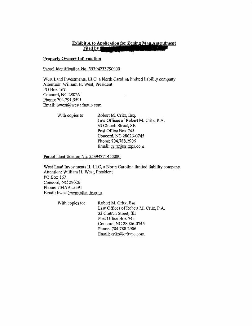
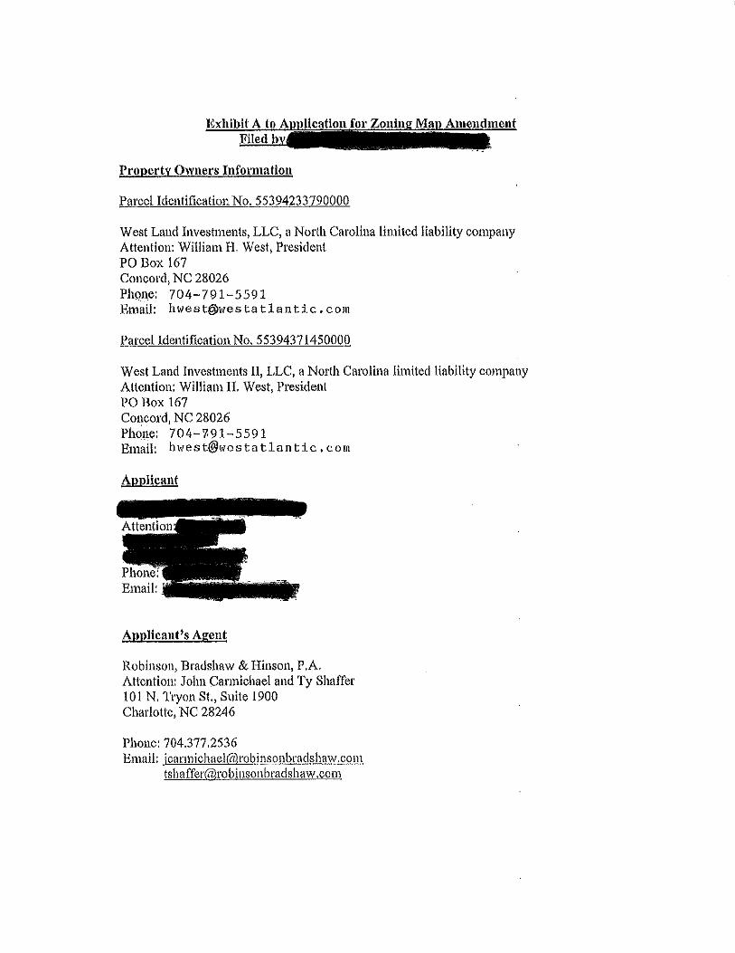
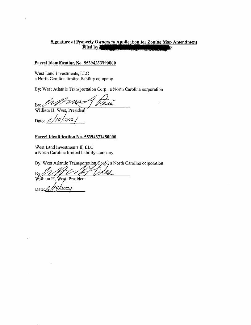
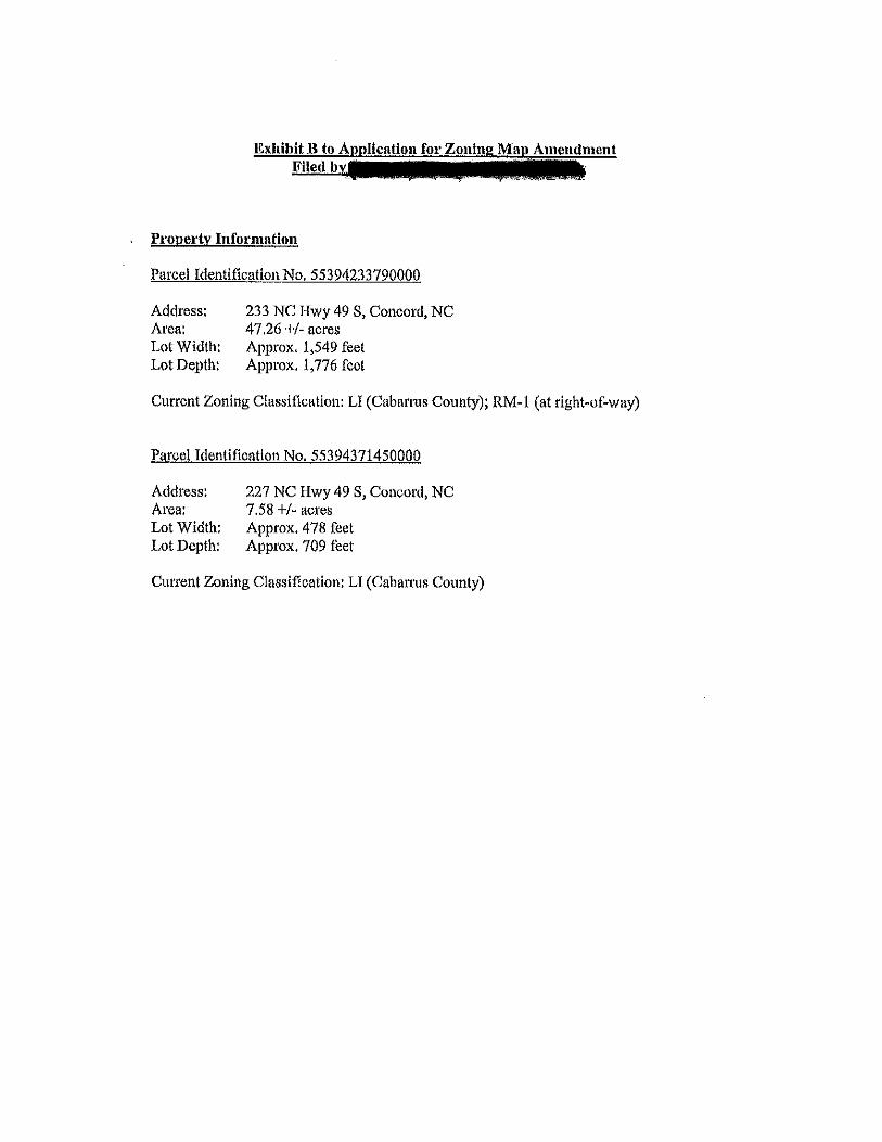
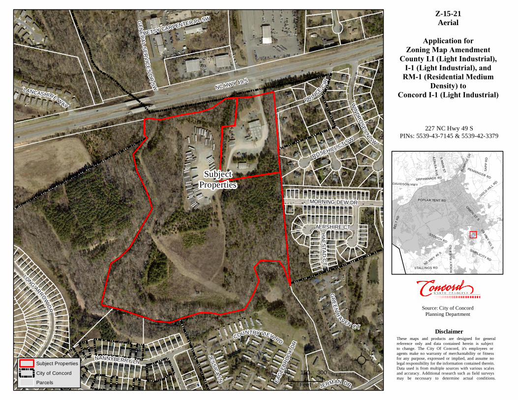
APPLICANT: Robinson, Bradshaw, & Hinson P.A. OWNER: West Land Investments LLC/West Land Investments LLC II LOCATION: 227 and 233 NC Hwy 49 South PIN#s: 5539-43-7145 and 5539-42-3379 AREA: +/- 53.355 acres
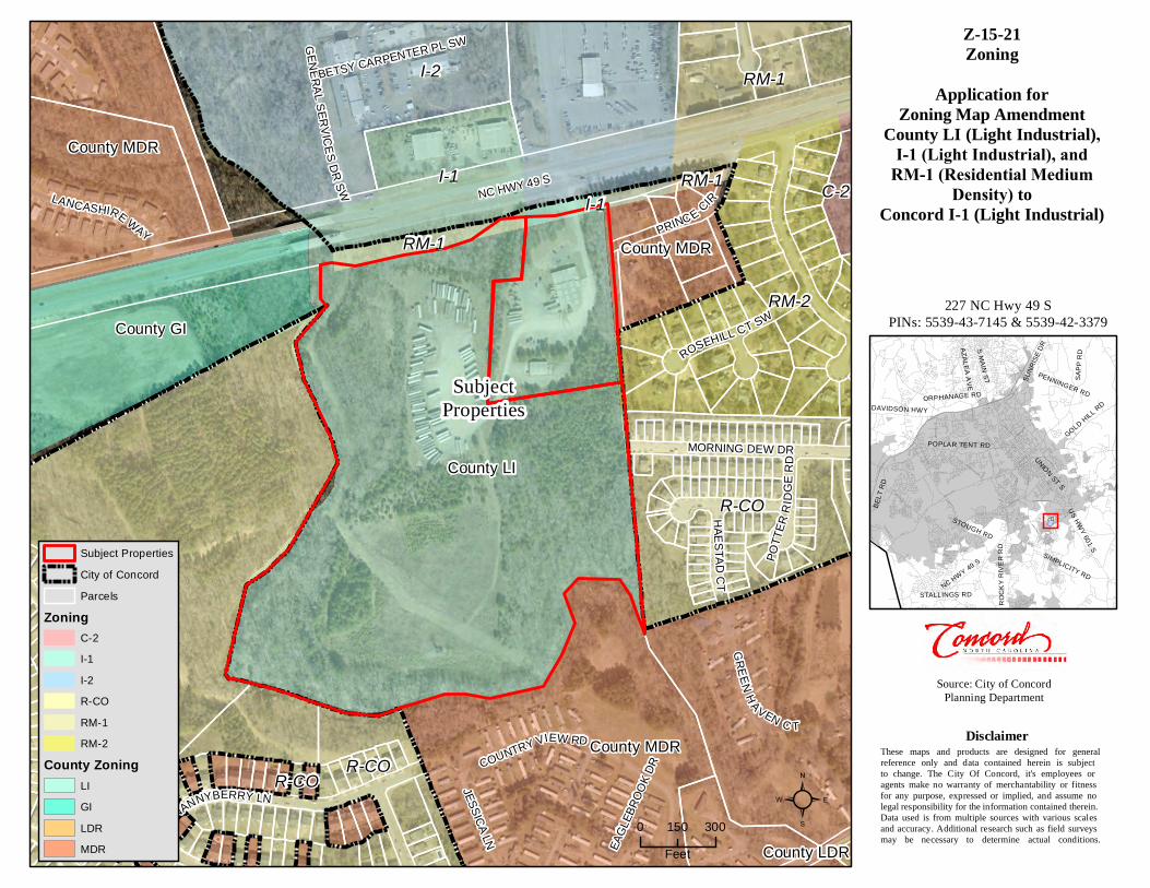
ZONING: Cabarrus County LI (Limited Industrial), City I-1 (Light
Industrial), and City RM-1 (Residential Medium Density) PREPARED BY: Starla Rogers, Planning and Development Manager
BACKGROUND The subject property consists of two (2) parcels, comprising approximately 53.355 acres located at 227 and 233 NC Hwy 49, South. The property is currently developed with two industrial structures. The larger structure is +/- 12,168sf and the smaller is +/- 3,500sf. The remainder of the site is either improved for outdoor vehicular/trailer storage parking or remains undisturbed.
HISTORY The subject property is owned by West Land Investments LLC/West Land Investments LLC II. Annexation of the subject property was adopted by City Council on July 20th at their regularly scheduled 11:00 a.m. hearing. Prior to annexation, a small portion of the subject property remained within the City’s ETJ and was zoned RM-1 and I-1. The property within the ETJ encompassed less than 20,000sf. The remainder of the property was in Cabarrus County’s jurisdiction and zoned LI. SUMMARY OF REQUEST The request is an economic development project titled “Project Independence.” The applicant has proposed to rezone the subject property from Cabarrus County LI (Limited Industrial), City I-1 (Light Industrial), and City RM-1 (Residential Medium Density) to I-1 (Light Industrial) in order to develop a +/- 198,500sf product distribution facility on the site. Product distribution facilities are permitted in I-1 zoning, only with the issuance of a Special Use Permit, which would require a quasi-judicial hearing before the Planning and Zoning Commission at a subsequent meeting. If the
Case Z-15-21 2
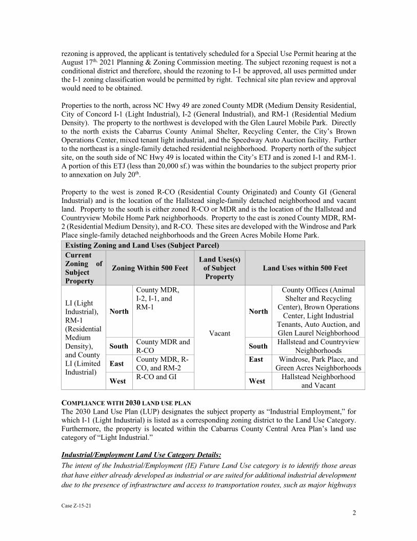
rezoning is approved, the applicant is tentatively scheduled for a Special Use Permit hearing at the August 17th, 2021 Planning & Zoning Commission meeting. The subject rezoning request is not a conditional district and therefore, should the rezoning to I-1 be approved, all uses permitted under the I-1 zoning classification would be permitted by right. Technical site plan review and approval would need to be obtained. Properties to the north, across NC Hwy 49 are zoned County MDR (Medium Density Residential, City of Concord I-1 (Light Industrial), I-2 (General Industrial), and RM-1 (Residential Medium Density). The property to the northwest is developed with the Glen Laurel Mobile Park. Directly to the north exists the Cabarrus County Animal Shelter, Recycling Center, the City’s Brown Operations Center, mixed tenant light industrial, and the Speedway Auto Auction facility. Further to the northeast is a single-family detached residential neighborhood. Property north of the subject site, on the south side of NC Hwy 49 is located within the City’s ETJ and is zoned I-1 and RM-1. A portion of this ETJ (less than 20,000 sf.) was within the boundaries to the subject property prior to annexation on July 20th. Property to the west is zoned R-CO (Residential County Originated) and County GI (General Industrial) and is the location of the Hallstead single-family detached neighborhood and vacant land. Property to the south is either zoned R-CO or MDR and is the location of the Hallstead and Countryview Mobile Home Park neighborhoods. Property to the east is zoned County MDR, RM-2 (Residential Medium Density), and R-CO. These sites are developed with the Windrose and Park Place single-family detached neighborhoods and the Green Acres Mobile Home Park.
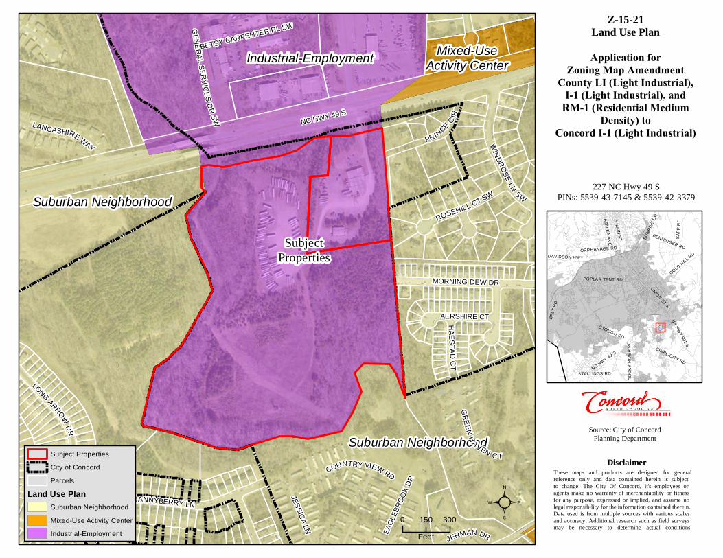
COMPLIANCE WITH 2030 LAND USE PLAN The 2030 Land Use Plan (LUP) designates the subject property as “Industrial Employment,” for which I-1 (Light Industrial) is listed as a corresponding zoning district to the Land Use Category. Furthermore, the property is located within the Cabarrus County Central Area Plan’s land use category of “Light Industrial.” Industrial/Employment Land Use Category Details: The intent of the Industrial/Employment (IE) Future Land Use category is to identify those areas that have either already developed as industrial or are suited for additional industrial development due to the presence of infrastructure and access to transportation routes, such as major highways
Existing Zoning and Land Uses (Subject Parcel) Current Zoning of Subject Property
Zoning Within 500 Feet Land Uses(s)
of Subject Property
Land Uses within 500 Feet
LI (Light Industrial), RM-1 (Residential Medium Density), and County LI (Limited Industrial)
North
County MDR, I-2, I-1, and RM-1
Vacant
North
County Offices (Animal Shelter and Recycling
Center), Brown Operations Center, Light Industrial
Tenants, Auto Auction, and Glen Laurel Neighborhood
South County MDR and R-CO South Hallstead and Countryview
Neighborhoods
East County MDR, R-CO, and RM-2
East Windrose, Park Place, and Green Acres Neighborhoods
West R-CO and GI West Hallstead Neighborhood and Vacant
Case Z-15-21 3
and railroads. These industrial areas should be preserved for employment uses to generate jobs for the community.
Industrial uses have already developed in several areas throughout the community, most of which are light industrial in function and impact. The 2030 Plan identifies the need to protect industrial lands, and to encourage additional growth in industrial/employment uses in designated areas, particularly around Concord Regional Airport, and along I-85 between Pitts School Road and Rocky River. Additionally, some light industrial/employment uses are encouraged to locate in Mixed-Use Districts, depending upon their intensity, as identified earlier in this section.
Industrial/Employment Land Use Plan detail and guidance includes: 5.2 (General Guidance)
Providing adequate infrastructure and services for residents and businesses, both now and in the future. In addition to adequate transportation infrastructure, development requires utilities, stormwater facilities and a variety of services to function properly. As the City grows, it must coordinate the expansion of its infrastructure and services with growth in ways that maintain adequate levels of service for existing and new development in a fiscally sustainable manner.
Policy Guidance for Objective 1.2:
Future Land Use Map Amendments: Prior to amending the Future Land Use Map, make findings that the proposed amendment will:
- Be consistent with the Plan goals and objectives;
- Be compatible with future land uses for surrounding areas;
- Not create a shortage of any category of residential or non-residential land; and
- Enhance the overall quality of life in the community. Objective 1.3: Ensure that the Future Land Use Map allows sufficient development opportunities
to meet existing and projected needs for residential, commercial, industrial and other land uses.
Objective 1.4: Protect existing and future industrial sites from encroachment of development that would limit their intended uses.
Policy Guidance for Objective 1.4:
Adjacent Development: Ensure that adjacent development and street networks are designed to safely and compatibly accommodate planned industrial uses and resulting traffic.
Site Development: Limit non-industrial uses to those that are accessory to existing uses or uses to be developed concurrently with the accessory uses.
Goal 4: Ensure compatibility between neighboring land uses. Objective 4.1: Use a combination of land use transitions, intensity gradients, buffering and
design to ensure that land use transitions are compatible.
Objective 4.2: Ensure that industrial and commercial developments are designed to limit encroachment of incompatible traffic, noise, odors and lighting into nearby residential areas.
Case Z-15-21 4
Policy Guidance for Objectives 4.1 to 4.3:
Land Use and Intensity Transitions: Zoning use and site development standards should promote a gradient in the type and intensity of uses. For instance, higher density residential development can provide a compatible transition between medium-density residences and neighborhood commercial centers.
Buffers: Buffers should be used to screen uses and activities that may detract from the enjoyment of adjacent land uses. Where large buffers are not necessary, the landscape design should soften land use transitions.
SUGGESTED STATEMENT OF CONSISTENCY
• The subject property is approximately +/- 53.355 acres and is zoned Cabarrus County LI (Limited Industrial), City I-1 (Light Industrial), and City RM-1 (Residential Medium Density).
• The subject property was annexed on July 20th, 2021 and is improved with two industrial
structures and associated parking.
• The proposed zoning amendment is consistent with the 2030 Land Use Plan (LUP) as I-1 (Light Industrial) is a corresponding zoning classification to the “Industrial Employment” Land Use Category. Additionally, the subject property is located in the Light Industrial land use designation of the Cabarrus County Central Area Plan, incorporated into the 2030 Land Use Plan, as the proposal is for light industrial zoning. Further, the request would be an extension of the existing I-1 (Light Industrial) zoning on a portion of the subject property as well as on properties to the north across NC Hwy 49 South.
• The zoning amendment is reasonable and in the public interest as it is consistent with the industrially zoned and developed properties to the north and west. The property currently has an industrial zoning classification within Cabarrus County (LI) and the proposed I-1 zoning classification is the most similar zoning classification, to the existing County zoning, within the City of Concord. The request would allow for the development of job producing industrial development on NC Hwy 49 S., where the existing street infrastructure can accommodate the industrial needs.
SUGGESTED RECOMMENDATION AND CONDITIONS The staff finds the request is consistent with the 2030 Land Use Plan, and has no objections to the petition. PROCEDURAL CONSIDERATIONS This particular case is a rezoning, which under the CDO, is “legislative” in nature. Legislative hearings DO NOT require the swearing or affirming of witnesses prior to testimony at the public hearing.

NC HWY 49 S
NANNYBERRY LN
LONG ARROWDR
PRINCE C IR
WINDROSE LN SW
MORNING DEW DR
COUNTRY VIEW RD
ROSEHILL CT SW
JESSICA LN
AERSHIRE CT
JERMAN DR
LANCASHIRE WAY
GREENH AVEN C T
GENERALSERVICES DRSW
HAESTAD CT
BETSY CARPENTER PL SW
EAGL
EBRO
OK DR
U S H W Y 29
R O G E R S LA K E R D
OAKW
OOD A
V E
WIN
EC
OF
F S
CH
OO
L R
D
R O B E R TA R D
M C G I LL AV E
LIN
CO
LN
ST
WA R R E N C C O LE M A N B L V D
N C 3
B RA N CH
VI EWD R
SE
W ED D IN G TO N R D
PI T T S S C H O O L R D
ZI O N C H U R C H R D
I-85
N C 1 3 6 M O O R E S VI L LE R D
MO R E H E A D R D
C O N C O R D P K WY S
C H U R C H ST N
WI L SH I R E A VE
G O LD H I L
L RD
OLD
CH
AR
LO
TTE
RD
D A L E E AR N H ARD T
BL V
D
C ABA R R U S A
VE
P EN
NIN
GE
RR
D
O LD A I R P O R T R D
INT
ER
NA
TIO
NAL
DR
RO
CK
Y R
I VE
R R
D
NC
3
BU R
RA G
ER
D
N E
U N ION S T S
FLO
WE S
S TO
RE
RD
CO
NC
OR
D P
AR
KWA
Y N
MALL
DR N
E
C O P P ER FI E L D
B LV D
NE
C EN T E R G R O V E RD
CR
ES
TM
ON
TD
R
BR U T O N S M I T H B LV D
PI T T S S C H OO L R D
TR I N I T Y C H U R CH R D
BOY S C O U T C A MP R D
R O C K H IL L C H U R C H R D
LIT
TLE
TE
XA
S R
D
BRO O
KW
OO
DA
V E
MI D
LAK
E AV
E
N C 7 3
P O P L A R TE N T RD
GE OR G E W L I LE S P K WY N W
RO BE R
TAC
H UR
CH
RD
N C H W Y 49
OLD
CH
AR
LO
TTE
RD
C O R B A N A V E
DAVIDSON HWY
US HWY 601 S
POPLAR TENT RD
SAPP
RDS MAIN ST
NC HWY 49 S
UNION ST S
GOLD HILL RD
ROCK
Y RI
VER
RD
STOUGH RD
ORPHANAGE RD
PENNINGER RD
SIMPLICITY RD
AZALEA AVE SUNR
ISE D
R
STALLINGS RD
BELT
RD
Source: City of ConcordPlanning Department
Z-15-21Aerial
Application forZoning Map Amendment
County LI (Light Industrial), I-1 (Light Industrial), and
RM-1 (Residential Medium Density) to
Concord I-1 (Light Industrial)
These maps and products are designed for generalreference only and data contained herein is subject to change. The City Of Concord, it's employees or agents make no warranty of merchantability or fitness for any purpose, expressed or implied, and assume no legal responsibility for the information contained therein. Data used is from multiple sources with various scales and accuracy. Additional research such as field surveys may be necessary to determine actual conditions.
Disclaimer
²0 300150Feet
Subject PropertiesCity of ConcordParcels
SubjectProperties
227 NC Hwy 49 SPINs: 5539-43-7145 & 5539-42-3379
County LI
County MDR
County GI
County MDR
County MDR
County LDR
I-2
R-CO
RM-2
I-1
R-CO
RM-1
R-CO
I-1 C-2
RM-1
RM-1
R-CO
NC HWY 49 S
NANNYBERRY LN
LONG ARROWDR
PRINCE CIR
MORNING DEW DR
COUNTRY VIEW RD
ROSEHILL CT SW
JESSICA LN
LANCASHIRE WAY
GREENH AVEN C T
GENERALSERVICES DRSW
HAESTAD CT
BETSY CARPENTER PL SW
POTT
ERRI
DGE R
D
EAGL
EBRO
OK DR
U S H W Y 29
R O G E R S LA K E R D
OAKW
OOD A
V E
WIN
EC
OF
F S
CH
OO
L R
D
R O B E R TA R D
M C G I LL AV E
LIN
CO
LN
ST
WA R R E N C C O LE M A N B L V D
N C 3
B RA N CH
VI EWD R
SE
W ED D IN G TO N R D
PI T T S S C H O O L R D
ZI O N C H U R C H R D
I-85
N C 1 3 6 M O O R E S VI L LE R D
MO R E H E A D R D
C O N C O R D P K WY S
C H U R C H ST N
WI L SH I R E A VE
G O LD H I L
L RD
OLD
CH
AR
LO
TTE
RD
D A L E E AR N H ARD T
BL V
D
C ABA R R U S A
VE
P EN
NIN
GE
RR
D
O LD A I R P O R T R D
INT
ER
NA
TIO
NAL
DR
RO
CK
Y R
I VE
R R
D
NC
3
BU R
RA G
ER
D
N E
U N ION S T S
FLO
WE S
S TO
RE
RD
CO
NC
OR
D P
AR
KWA
Y N
MALL
DR N
E
C O P P ER FI E L D
B LV D
NE
C EN T E R G R O V E RD
CR
ES
TM
ON
TD
R
BR U T O N S M I T H B LV D
PI T T S S C H OO L R D
TR I N I T Y C H U R CH R D
BOY S C O U T C A MP R D
R O C K H IL L C H U R C H R D
LIT
TLE
TE
XA
S R
D
BRO O
KW
OO
DA
V E
MI D
LAK
E AV
E
N C 7 3
P O P L A R TE N T RD
GE OR G E W L I LE S P K WY N W
RO BE R
TAC
H UR
CH
RD
N C H W Y 49
OLD
CH
AR
LO
TTE
RD
C O R B A N A V E
DAVIDSON HWY
US HWY 601 S
POPLAR TENT RD
SAPP
RDS MAIN ST
NC HWY 49 S
UNION ST S
GOLD HILL RD
ROCK
Y RI
VER
RD
STOUGH RD
ORPHANAGE RD
PENNINGER RD
SIMPLICITY RD
AZALEA AVE SUNR
ISE D
R
STALLINGS RD
BELT
RD
Source: City of ConcordPlanning Department
Z-15-21Zoning
Application forZoning Map Amendment
County LI (Light Industrial), I-1 (Light Industrial), and
RM-1 (Residential Medium Density) to
Concord I-1 (Light Industrial)
These maps and products are designed for generalreference only and data contained herein is subject to change. The City Of Concord, it's employees or agents make no warranty of merchantability or fitness for any purpose, expressed or implied, and assume no legal responsibility for the information contained therein. Data used is from multiple sources with various scales and accuracy. Additional research such as field surveys may be necessary to determine actual conditions.
Disclaimer
²0 300150Feet
Subject PropertiesCity of ConcordParcels
ZoningC-2I-1I-2R-CORM-1RM-2
County ZoningLIGILDRMDR
SubjectProperties
227 NC Hwy 49 SPINs: 5539-43-7145 & 5539-42-3379
Suburban Neighborhood
Industrial-Employment Mixed-UseActivity Center
Suburban Neighborhood
NC HWY 49 S
NANNYBERRY LN
LONG ARROWDR
PRINCE C IR
WINDROSE LN SW
MORNING DEW DR
COUNTRY VIEW RD
ROSEHILL CT SW
JESSICA LN
AERSHIRE CT
JERMAN DR
LANCASHIRE WAY
GREENH AVEN C T
GENERALSERVICES DRSW
HAESTAD CT
BETSY CARPENTER PL SW
EAGL
EBRO
OK DR
U S H W Y 29
R O G E R S LA K E R D
OAKW
OOD A
V E
WIN
EC
OF
F S
CH
OO
L R
D
R O B E R TA R D
M C G I LL AV E
LIN
CO
LN
ST
WA R R E N C C O LE M A N B L V D
N C 3
B RA N CH
VI EWD R
SE
W ED D IN G TO N R D
PI T T S S C H O O L R D
ZI O N C H U R C H R D
I-85
N C 1 3 6 M O O R E S VI L LE R D
MO R E H E A D R D
C O N C O R D P K WY S
C H U R C H ST N
WI L SH I R E A VE
G O LD H I L
L RD
OLD
CH
AR
LO
TTE
RD
D A L E E AR N H ARD T
BL V
D
C ABA R R U S A
VE
P EN
NIN
GE
RR
D
O LD A I R P O R T R D
INT
ER
NA
TIO
NAL
DR
RO
CK
Y R
I VE
R R
D
NC
3
BU R
RA G
ER
D
N E
U N ION S T S
FLO
WE S
S TO
RE
RD
CO
NC
OR
D P
AR
KWA
Y N
MALL
DR N
E
C O P P ER FI E L D
B LV D
NE
C EN T E R G R O V E RD
CR
ES
TM
ON
TD
R
BR U T O N S M I T H B LV D
PI T T S S C H OO L R D
TR I N I T Y C H U R CH R D
BOY S C O U T C A MP R D
R O C K H IL L C H U R C H R D
LIT
TLE
TE
XA
S R
D
BRO O
KW
OO
DA
V E
MI D
LAK
E AV
E
N C 7 3
P O P L A R TE N T RD
GE OR G E W L I LE S P K WY N W
RO BE R
TAC
H UR
CH
RD
N C H W Y 49
OLD
CH
AR
LO
TTE
RD
C O R B A N A V E
DAVIDSON HWY
US HWY 601 S
POPLAR TENT RD
SAPP
RDS MAIN ST
NC HWY 49 S
UNION ST S
GOLD HILL RD
ROCK
Y RI
VER
RD
STOUGH RD
ORPHANAGE RD
PENNINGER RD
SIMPLICITY RD
AZALEA AVE SUNR
ISE D
R
STALLINGS RD
BELT
RD
Source: City of ConcordPlanning Department
Z-15-21Land Use Plan
Application forZoning Map Amendment
County LI (Light Industrial), I-1 (Light Industrial), and
RM-1 (Residential Medium Density) to
Concord I-1 (Light Industrial)
These maps and products are designed for generalreference only and data contained herein is subject to change. The City Of Concord, it's employees or agents make no warranty of merchantability or fitness for any purpose, expressed or implied, and assume no legal responsibility for the information contained therein. Data used is from multiple sources with various scales and accuracy. Additional research such as field surveys may be necessary to determine actual conditions.
Disclaimer
²0 300150Feet
Subject PropertiesCity of ConcordParcels
Land Use PlanSuburban NeighborhoodMixed-Use Activity CenterIndustrial-Employment
SubjectProperties
227 NC Hwy 49 SPINs: 5539-43-7145 & 5539-42-3379